
Protection of Environmental and Natural Values of Urban Areas against Investment Pressure: A Case Study of Romania and Poland
 , ,
, ,  ,
,
Abstract
:1. Introduction
1.1. Background
1.2. Specific Issues
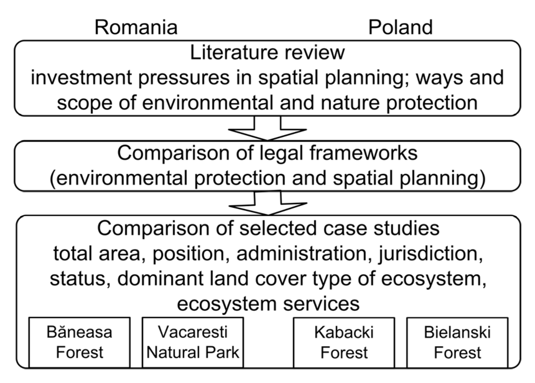
2. Methods
3. Results
3.1. Comparison of Nature Conservation Systems and Urban Pressures in Romania and Poland
3.1.1. Romania Nature Conservation
- (a)
- Historical background
- (b)
- Description of the current system
- Principles
- 2.
- Categories
- 3.
- Management
- 4.
- Urban pressure
3.1.2. Poland
Nature Conservation
- (a)
- Historical background
- (b)
- Description of the current system
- Principles
- 2.
- Categories
- 3.
- Management
- 4.
- Urban pressure
3.2. Comparison of Selected Case Studies in Romania and Poland
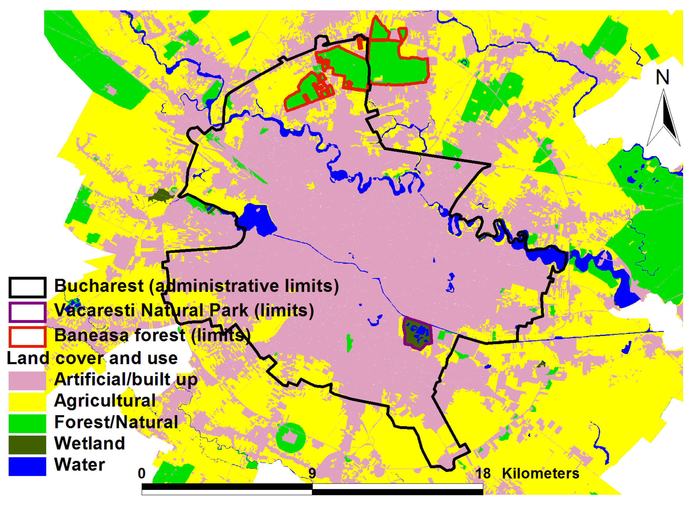
3.2.1. Romania
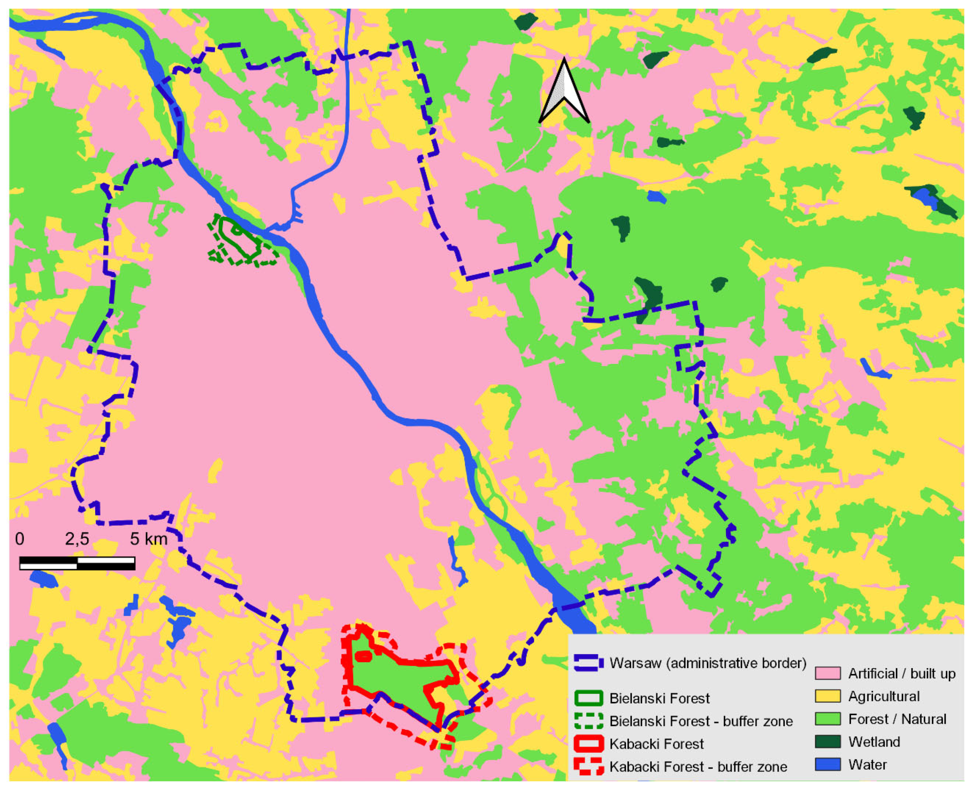
3.2.2. Poland
3.2.3. Comparison of Case Studies
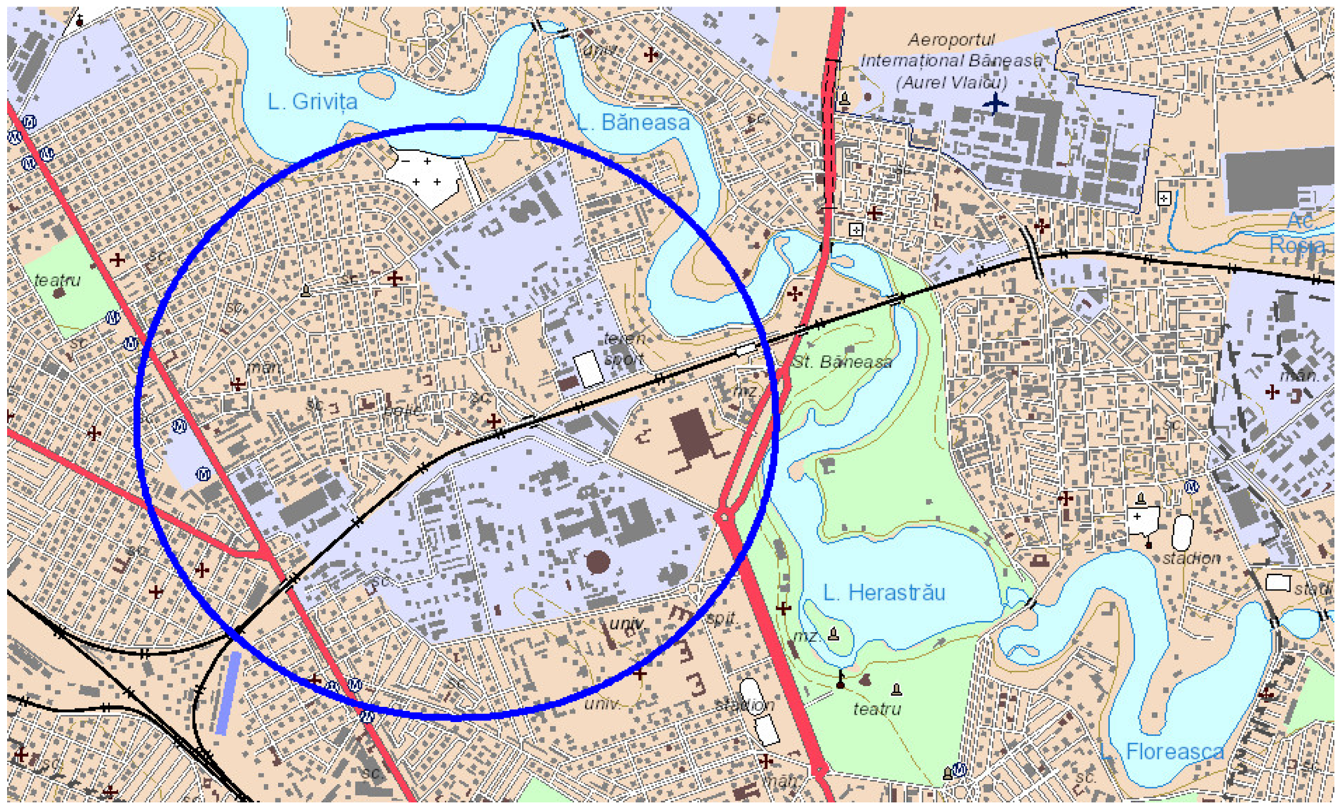
Băneasa Forest Analysis of Natural Object and Constraints for Spatial Development
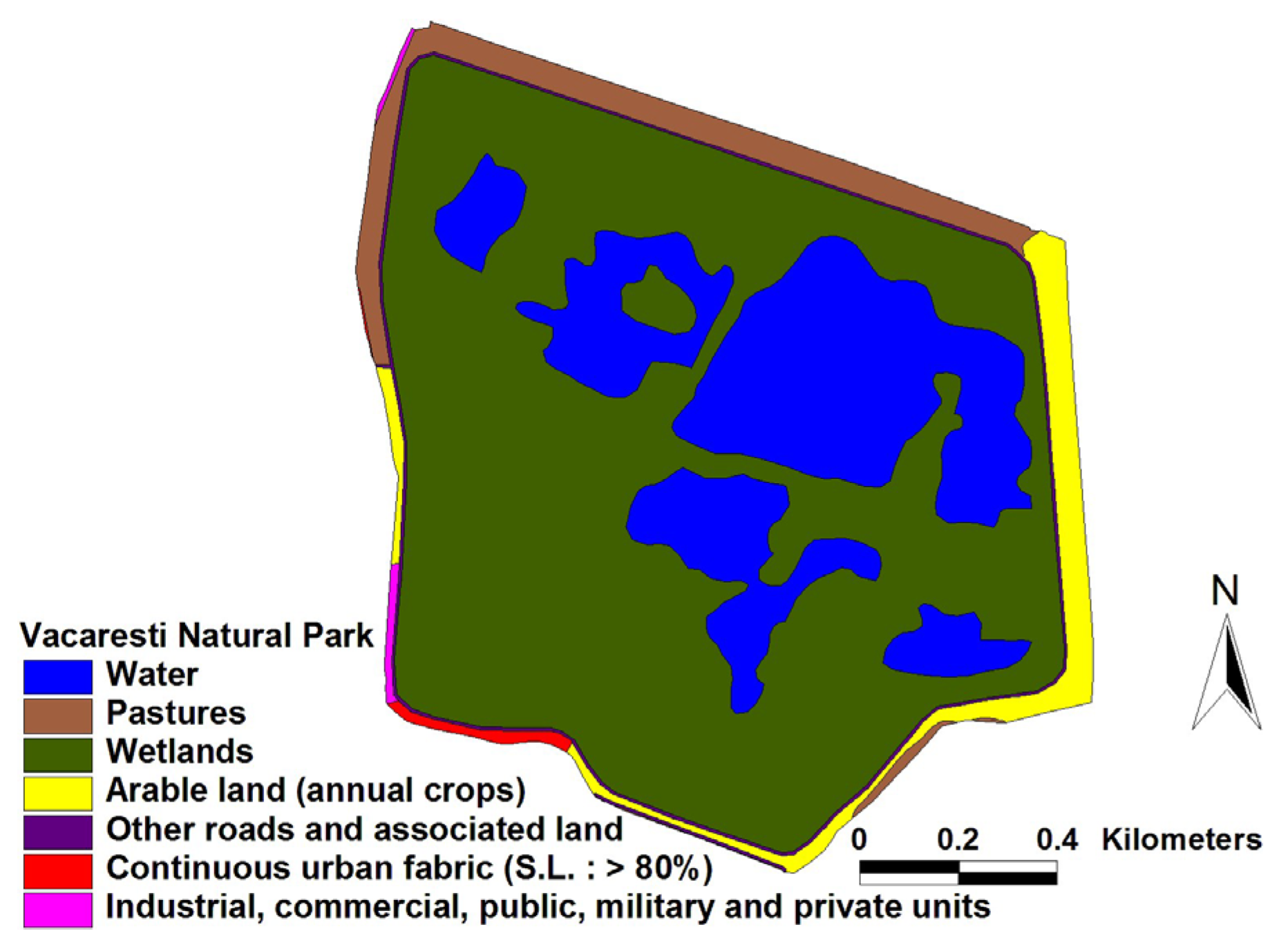
Vacaresti Nature Park Analysis of Natural Object and Constraints for Spatial Development
Kabacki Forest Analysis of Natural Object and Constraints for Spatial Development
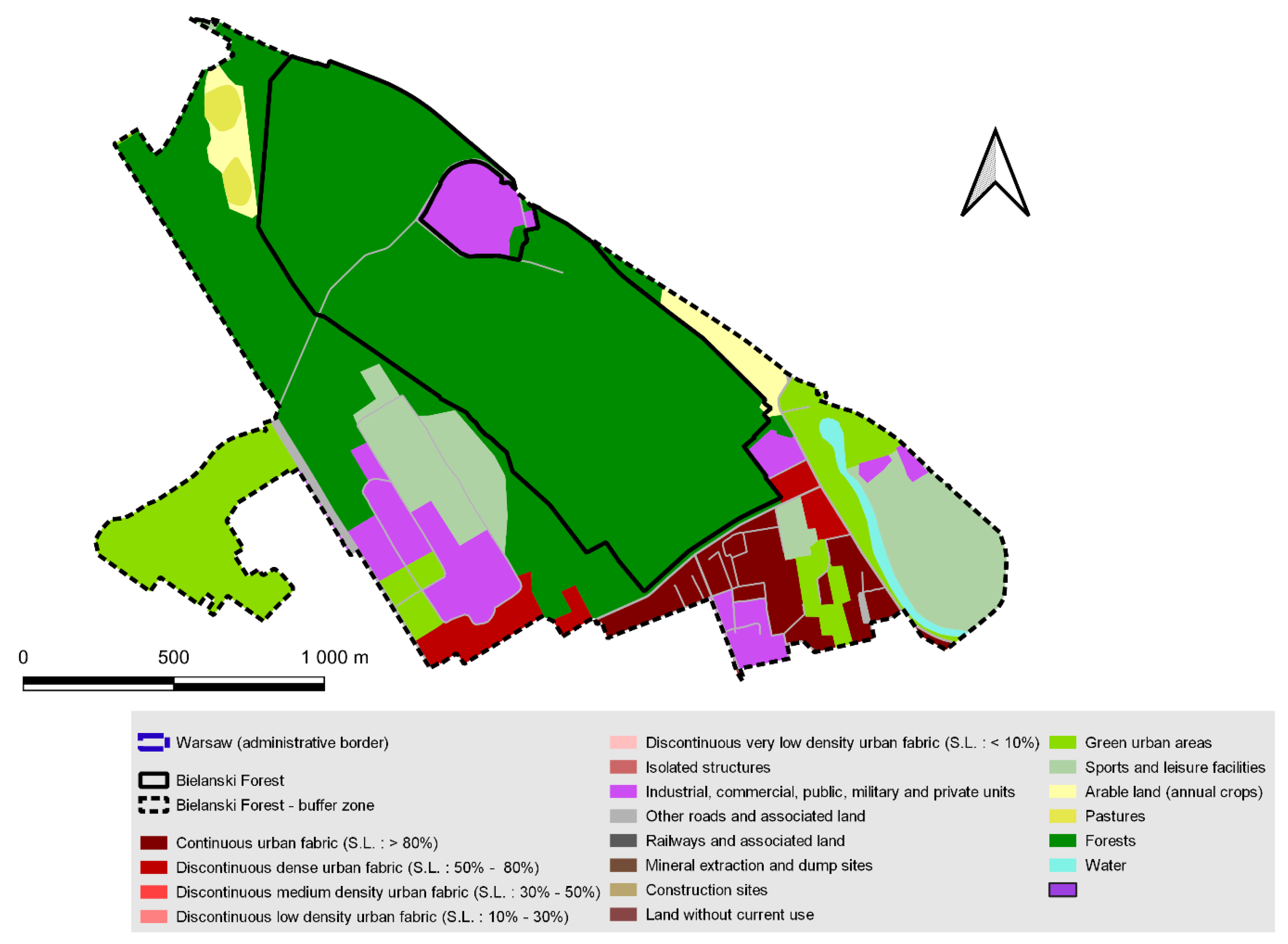
Bielanski Forest Analysis of Natural Object and Constraints for Spatial Development
- Climatic: it affects the microclimate of the district;
- Scientific: a valuable research object providing an opportunity to track the response of relict biocoenoses and species to the anthropogenic impacts of the big city;
- Didactic: a place for field classes for students and pupils of Warsaw schools;
- Social: a recreational area, satisfying the need for contact with “real” nature to a much better degree than other green areas of the city;
- Landscape: a characteristic component of Warsaw’s Vistula River panorama
3.3. Comparison of Management Institutions and Key Legal Documents That Coordinate Protection of Natural Assets and Urban Planning
4. Discussion
- A comparison of the planning protection of environmentally valuable areas in other Central and Eastern European cities. The countries of Central and Eastern Europe are similar in many respects in the sphere of spatial policy. The criterion proposed in this article, involving the balancing of central and urban perspectives through an integrated multi-scalar approach, can be an important point of reference;
- Another aspect of research that should be developed relates to thorough studies of the ecosystem services provided by naturally valuable areas in cities, especially related to non-material aspects. In addition, environmentally valuable areas in cities should be subject to multifaceted environmental valuation [145,146];
- On a similar note, it is worth reviewing the feasibility of planning protection for areas of value using a trans-disciplinary approach for complex landscapes [147] and a cultural heritage perspective [148], linking national and local environmental and urban planning [138]. This thematic scope also needs to be substantiated in international comparisons that discuss the importance of current landscapes as a development milestone in spatial and territorial planning theories [149], as well as different approaches to the new spatial urbanism or other directions and theories of urban and territorial planning [150];
- Another important topic concerns the further comparison (alignment) of nature conservation-related, planning, and legal terminology. Many systems have major discrepancies in this respect. These are often the basis for the weakness of spatial plans insofar as they relate to the natural sphere. This issue needs to be sorted out more extensively.
5. Conclusions
Author Contributions
Funding
Institutional Review Board Statement
Informed Consent Statement
Data Availability Statement
Acknowledgments
Conflicts of Interest
References
- Petrişor, A.-I.; Petrişor, L.E. 25 years of sustainability. A critical analysis. Present Environ. Sustain. Dev. 2014, 8, 175–190. [Google Scholar]
- Hersperger, A.M.; Iojă, I.C.; Steiner, F.; Tudor, C.A. Comprehensive consideration of conflicts in the land-use planning process: A conceptual contribution. Carpathian J. Earth Environ. Sci. 2015, 10, 5–13. [Google Scholar]
- Chomitz, K.M.; Alger, K.; Thomas, T.S.; Orlando, H.; Vila Nova, P. Opportunity costs of conservation in a biodiversity hotspot: The case of southern Bahia. Environ. Dev. Econ. 2005, 10, 293–312. [Google Scholar]
- Beauregard, R.A. Between Modernity and Postmodernity: The Ambiguous Position of US Planning. Environ. Plan. D 1989, 7, 381–395. [Google Scholar]
- Boulton, C.; Dedekorkut-Howes, A.; Byrne, J. Factors shaping urban greenspace provision: A systematic review of the literature. Landsc. Urban Plan. 2018, 178, 82–101. [Google Scholar]
- Steele, W.; Ruming, K.J. Flexibility versus Certainty: Unsettling the Land-use Planning Shibboleth in Australia. Plan. Pract. Res. 2012, 27, 155–176. [Google Scholar]
- King-Cullen, R. Mastering the Art of Planning. 100 Stories from Urban Planning Practice; Garry G. Parsons: London, UK, 2015. [Google Scholar]
- Moroni, S.; Buitelaar, E.; Sorel, N.; Cozzolino, S. Simple Planning Rules for Complex Urban Problems: Toward Legal Certainty for Spatial Flexibility. J. Plan. Educ. Res. 2020, 40, 320–331. [Google Scholar]
- Crăciun, C. Urban Health and Pathology. Rom. Acad Forum J. 2009, 2, 80. [Google Scholar]
- Yakusheva, N. Managing protected areas in Central Eastern Europe: Between path-dependence and Europeanisation. Land Use Policy 2019, 87, 104036. [Google Scholar]
- Braun, B.P. A New Urban Dispositif? Governing Life in an Age of Climate Change. Environ. Plan. D Soc. Space 2014, 32, 49–64. [Google Scholar]
- Nowak, M.; Śleszyński, P.; Legutko-Kobus, P. Spatial Planning in Poland. Law, Property Market and Planning Practice; Springer: Berlin/Heidelberg, Germany, 2022. [Google Scholar]
- Chigudu, A.; Chavunduka, C. The Tale of Two Capital Cities: The Effects of Urbanisation and Spatial Planning Heritage in Zimbabwe and Zambia. Urban Forum 2021, 32, 33–47. [Google Scholar]
- Horn, A. The history of urban growth management in South Africa: Tracking the origin and current status of urban edge policies in three metropolitan municipalities. Plan. Perspect. 2019, 34, 959–977. [Google Scholar]
- Slaev, A.D. The relationship between planning and the market from the perspective of property rights theory: A transaction cost analysis. Plan. Theory 2017, 16, 404–424. [Google Scholar]
- Belkaid, E.; Alili, A.; Hamma, W. The adaptability of the stakeholder theory in urban areas. Algerian J. Eng. Archit. Urban. 2017, 1, 21–32. [Google Scholar]
- Kleemann, J.; Inkoom, J.N.; Thiel, M.; Shankar, S.; Lautenbach, S.; Fürst, C. Peri-urban land use pattern and its relation to land use planning in Ghana, West Africa. Landsc. Urban Plan. 2017, 165, 280–294. [Google Scholar]
- Papageoriou, C.; Saam, M.; Schulte, P. Substitution between Clean and Dirty Energy Inputs: A Macroeconomic Perspective. Rev. Econ. Stat. 2017, 99, 281–290. [Google Scholar]
- Berisha, E.; Cotella, G.; Janin-Rivolin, U.; Solly, A. Spatial governance and planning systems and the public control of spatial development: A European typology. Eur. Plan. Stud. 2020, 29, 181–200. [Google Scholar]
- Soulard, C.T.; Valette, E.; Perrin, C.; Abrantes, P.C.; Anthopoulou, T.; Benjaballah, O.; Bouchema, S.; Dugue, P.; El Amrani, M.; Lardon, S.; et al. Peri-urban agro-ecosystems in the Mediterranean: Diversity, dynamics, and drivers. Reg. Environ. Chang. 2017, 18, 651–662. [Google Scholar]
- La Rosa, D.; Geneletti, D.; Spyra, M.; Albert, C. Sustainable planning for peri-urban landscapes. In Ecosystem Services from Forest Landscapes; Perera, A.H., Peterson, U., Martínez Pastur, G.J., Iverson, L.R., Eds.; Springer International Publishing: Cham, Switzerland, 2018; pp. 89–126. [Google Scholar]
- Śleszyński, P.; Kowalewski, A.; Markowski, T.; Legutko-Kobus, P.; Nowak, M. The Contemporary Economic Costs of Spatial Chaos: Evidence from Poland. Land 2020, 9, 214. [Google Scholar]
- Weitkamp, A.; Klein, I.M.; Friesecke, F. Strategies of Developing Building Land in Growing Cities. In Land Ownership and Land Use Development—The Integration of Past, Present, and Future in Spatial Planning and Land Management Policies; European Academy of Land Use and Development (EALD): Dresden, Germany, 2017; pp. 327–340. [Google Scholar]
- Debrunner, G.; Hartmann, T. Strategic use of land policy instruments for affordable housing—Coping with social challenges under scarce land conditions in Swiss cities. Land Use Policy 2020, 99, 104993. [Google Scholar]
- Monstadt, J.; Meilinger, V. Governing Suburbia through regionalized land-use planning? Experiences from the Greater Frankfurt region. Land Use Polivy 2020, 91, 104300. [Google Scholar]
- Hsu, A.; Sheriff, G.; Chakraborty, T.; Manya, D. Disproportionate exposure to urban heat island intensity across major US cities. Nat. Commun. 2021, 12, 2721. [Google Scholar]
- Meshkini, A.; Zarghamfard, M.; Kahaki, F. A comparative study of the right to the city in Iran. GeoJournal 2021, 87, 3101–3118. [Google Scholar]
- Bonfert, B. The real power must be in the base—Decentralised collective intellectual leadership in the European Action Coalition for the Right to Housing and to the City. Cap. Cl. 2021, 45, 523–542. [Google Scholar]
- Crăciun, C.; Acasandre, A. “The Right to the Landscape” and “The Landscape Right”. Landscape as a Tool of Meta-Ethic and Multidimen-sional Education in The Knowledge Society. New Approaches Soc. Humanist. Sci. 2016, 5, 173–181. [Google Scholar]
- Drăgănescu, M. Consciousness, frontier of science, frontier of humanity. Philos. Mag. 2000, 65, 15–20. [Google Scholar]
- Rega, C. A Closer Look to Processes of Territorial Transformations in Europe: Urbanization, Agricultural Intensification and Land Abandonment. In Ecological Rationality in Spatial Planning. Cities and Nature; Rega, C., Ed.; Springer: Cham, Switzerland, 2020; pp. 111–139. [Google Scholar]
- Petrişor, A.-I.; Petrişor, L.E. The shifting relationship between urban and spatial planning and the protection of the environment: Romania as a case study. Present Environ. Sustain. Dev. 2013, 7, 267–277. [Google Scholar]
- Popa, A.M.; Onose, D.A.; Sandric, I.C.; Dosiadis, E.A.; Petropoulos, G.P.; Gavrilidis, A.A.; Faka, A. Using GEOBIA and Vegetation Indices to Assess Small Urban Green Areas in Two Climatic Regions. Remote Sens. 2022, 14, 4888. [Google Scholar]
- Dale, V.H.; Efroymnson, R.A.; Kline, K.L. The land use—Climate change—Energy nexus. Landsc. Ecol. 2011, 26, 755–773. [Google Scholar]
- Alexander, E.R.; Faludi, A. Planning Doctrine: Its Uses and Implications. Plan. Theory 1996, 16, 11–61. [Google Scholar]
- Petrișor, A.-I.; Mierzejewska, L.; Mitrea, A.; Drachal, K.; Tache, A.V. Dynamics of Open Green Areas in Polish and Romanian Cities during 2006–2018: Insights for Spatial Planners. Remote Sens. 2021, 13, 4041. [Google Scholar]
- Legutko-Kobus, P.; Rzeńca, A.; Skubała, P.; Sobol, A. Miasta i ich Mieszkańcy w Obliczu Wyzwań Adaptacji do Zmian Klimatu; PAN: Warszawa, Poland, 2020. [Google Scholar]
- Concepción, E.D. Urban sprawl into Natura 2000 network over Europe. Conserv. Biol. 2021, 35, 1063. [Google Scholar]
- Santiago-Ramos, J.; Feria-Toribio, J.M. Assessing the effectiveness of protected areas against habitat fragmentation and loss: A long-term multi-scalar analysis in a mediterranean region. J. Nat. Conserv. 2021, 64, 126072. [Google Scholar]
- Kubacka, M.; Zywica, P.; Subiros, J.V.; Brodka, S.; Macias, A. How do the surrounding areas of national parks work in the context of landscape fragmentation? A case study of 159 protected areas selected in 11 EU countries. Land Use Policy 2022, 113, 105910. [Google Scholar]
- Tominaga, M. Urban and spatial planning in Japan. Urban. Archit. Constr. 2011, 2, 30–36. [Google Scholar]
- Pearce, D.; Markandya, A. Marginal opportunity cost as a planning concept in natural resource management. Ann. Reg. Sci. 1987, 21, 18–32. [Google Scholar]
- Norton-Griffiths, M.; Southey, C. The opportunity costs of biodiversity conservation in Kenya. Ecol. Econ. 1995, 12, 125–139. [Google Scholar]
- Tudor, C.A.; Iojă, I.C.; Pătru-Stupariu, I.; Niţă, M.R.; Hersperger, A.M. How successful is the resolution of land-use conflicts? A comparison of cases from Switzerland and Romania. Appl. Geogr. 2014, 47, 125–136. [Google Scholar]
- James, A.; Gaston, K.J.; Balmford, A. Can We Afford to Conserve Biodiversity? BioScience 2001, 51, 43–52. [Google Scholar]
- Ioannou, B.; Nicolaou, L. Planning for Investors: Urban Density and Public Space. In Proceedings of the AESOP Thematic Group for Public Spaces and Urban Cultures, Nicosia, Cyprus, 16–18 May 2018; Available online: https://www.researchgate.net/publication/325441206_Planning_for_Investors_Urban_Density_and_Public_Space (accessed on 30 October 2022).
- Butcher, S. Appropriating rent from greenfield affordable housing: Developer practices in Johannesburg. Environ. Plan. A Econ. Space 2020, 52, 337–361. [Google Scholar]
- Ratcliffe, J.; Stubbs, M.; Keeping, M. Urban Planning and Real Estate Development, 4th ed.; Routledge: New York, NY, USA, 2021. [Google Scholar]
- Raco, M.; Livingstone, N.; Durrant, D. Seeing like an investor: Urban development planning, financialisation, and investors’ perceptions of London as an investment space. Eur. Plan. Stud. 2019, 27, 1064–1082. [Google Scholar]
- Mcnamara, P. The changing nature of property investment: Implications for Urban Planning. In Connections: Exploring Contemporary Planning Theory and Practice with Patsy Healey; Hillier, J., Metzger, J., Eds.; Routledge: London, UK, 2017. [Google Scholar]
- Christensen, P.H.; Robinson, S.; Simons, R. Institutional investor motivation, processes, and expectations for sustainable building investment. Build. Res. Inf. 2022, 50, 276–290. [Google Scholar]
- Dunets, A.; Zhogowa, I.; Akimov, O. Spatial Planning for Health Tourism Development in Belokurikha Resort. J. Environ. Manag. Tour. 2019, 10, 1331–1337. [Google Scholar]
- Auziņš, A.; Viesturs, J. A Values-Led Planning Approach for Sustainable Land Use and Development. Balt. J. Real Estate Econ. Constr. Manag. 2017, 5, 275–286. [Google Scholar]
- Ioannou, B.; Nicolaou, L.; Serraos, K.; Spiliopoulou, G. Large urban developments as non-planning products: Conflicts and threats for spatial planning. Urban Plan. 2019, 4, 31–42. [Google Scholar]
- Österlin, C.; Raitio, K. Fragmented Landscapes and Planscapes—The Double Pressure of Increasing Natural Resource Exploitation on Indigenous Sámi Lands in Northern Sweden. Resources 2020, 9, 104. [Google Scholar]
- Hytönen, J. Limits of localism: Institutional perspectives on communicativeness, neoliberalization and sustainability in Finnish spatial planning. Nord. Geogr. Publ. 2019, 48, 110. [Google Scholar]
- Madanipour, A.; Hull, A. The Governance of Place: Space and Planning Processes; Routledge: London, UK, 2016. [Google Scholar]
- Carr, C.; McDonough, E. Integrative Planning of Post-suburban Growth in the Glatt Valley (Switzerland). Raumforsch. Raumordn. 2018, 76, 109–122. [Google Scholar]
- Morphet, J. Changing Contexts in Spatial Planning: New Directions in Policies and Practices; Routledge: London, UK, 2019. [Google Scholar]
- Morrissey, J.E.; Moloney, S.; Moore, T. Strategic spatial planning and urban transition: Revaluing planning and locating sustainability trajectories. In Urban Sustainability Transitions. Australian Cases—International Perspectives; Moore, T., de Haan, F., Horne, R., Gleeenson, B.J., Eds.; Springer: Berlin/Heidelberg, Germany, 2018; pp. 53–72. [Google Scholar]
- Heaphy, L.; Wiig, A. The 21st century corporate town: The politics of planning innovation districts. Telemat. Inform. 2020, 54, 101459. [Google Scholar]
- Yigitcanlar, T.; Teriman, S. Rethinking sustainable urban development: Towards an integrated planning and development process. Int. J. Environ. Sci. Technol. 2015, 12, 341–352. [Google Scholar]
- Berisha, E.; Colic, N.; Cotella, G.; Nedović-Budić, Z. Mind the gap: Spatial planning systems in the western Balkan region. Trans. Assoc. Eur. Sch. Plan. 2018, 2, 47–62. [Google Scholar]
- Nowak, M.; Petrisor, A.-I.; Mitrea, A.; Kovács, K.F.; Lukstina, G.; Jürgenson, E.; Ladzianska, Z.; Simeonova, V.; Lozynskyy, R.; Rezac, V.; et al. The Role of Spatial Plans Adopted at the Local Level in the Spatial Planning Systems of Central and Eastern European Countries. Land 2022, 11, 1599. [Google Scholar]
- Dąbrowski, M.; Piskorek, K. The development of strategic spatial planning in Central and Eastern Europe: Between path dependence, European influence, and domestic politics. Plan. Perspect. 2018, 33, 571–589. [Google Scholar]
- Tulumello, S.; Cotella, G.; Othengrafen, F. Spatial planning and territorial governance in Southern Europe between economic crisis and austerity policies. Int. Plan. Stud. 2020, 25, 72–87. [Google Scholar]
- Kunzmann, R.K. Spatial development and territorial cohesion in Europe. In Spatial Planning and Urban Development in the New EU Member States; Peters, D., Altrock, U., Güntner, S., Eds.; Routledge: London, UK, 2016. [Google Scholar]
- Gurran, N.; Bramley, G. Urban Planning and the Housing Market. International Perspectives for Policy and Practice; Palgrave Macmillan: London, UK, 2017. [Google Scholar]
- van Gent, W.; Hochstenbach, C. The neo-liberal politics and socio-spatial implications of Dutch post-crisis social housing policies. Int. J. Hous. Policy 2020, 20, 156–172. [Google Scholar]
- Barnes, A.; Nel, V. Putting spatial resilience into practice. Urban Forum 2017, 28, 219–232. [Google Scholar]
- Heurkens, E.; Remiry, H.; Hobma, F. Planning policy instruments for resilient urban redevelopment: The case of office conversions in Rotterdam, the Netherlands. In Building Urban Resilience through Change of Use; Wilkinson, S., Remoy, H., Eds.; John Wiley & Sons: New York, NY, USA, 2018; pp. 39–56. [Google Scholar]
- Kholmuratovna, K.Z. The environmental protection, the role of land support in creation of economic and legal mechanisms. JournalNX 2021, 7, 84–86. [Google Scholar]
- Lantitsou, K. Eco-development and environmental spatial planning. Fresenius Environ. Bull. 2017, 26, 1291–1300. [Google Scholar]
- Fedreheim, G.E.; Blanco, E. Co-management of protected areas to alleviate conservation conflicts: Experiences in Norway. Int. J. Commons 2017, 11, 756. [Google Scholar]
- Dachary-Bernard, J.; Gaschet, F.; Hautdidier, B.; Lemarié-Boutry, M.; Pouyanne, G. Entre protection et ouverture: Quels effets de la politique d’usage des sols sur les dynamiques de marché foncier sur le littoral aquitain? Sud-Ouest Eur. 2018, 45, 71–88. [Google Scholar]
- Cowell, R.; Fischer, T.B.; Jackson, T. Embedding the Environment in the Local Development Plan Process through SEA A Think Piece. 2020. Available online: https://www.researchgate.net/publication/352120387_Embedding_the_Environment_in_the_Local_Development_Plan_Process_through_SEA_A_think_piece (accessed on 30 October 2022).
- Gustaffson, S.; Hermelin, S.; Smas, B. Integrating environmental sustainability into strategic spatial planning: The importance of management. J. Environ. Plan. Manag. 2019, 62, 1321–1338. [Google Scholar]
- Papargeorgiou, M.; Gemenetzi, G. Spatial environmental planning in Athens and Thessaloniki. In Proceedings of the CEST 2017, Rhodes, Greece, 31 August–2 September 2017; Available online: https://www.researchgate.net/publication/320012015_Spatial_environmental_planning_in_Athens_and_Thessaloniki (accessed on 31 October 2022).
- Petrişor, A.-I.; Mierzejewska, L.; Mitrea, A. Mechanisms of Change in Urban Green Infrastructure—Evidence from Romania and Poland. Land 2022, 11, 592. [Google Scholar]
- Rodriguez, K. Unprecedented Times Provide an Environment for valYOU Recognition. ADCES Pract. 2021, 9, 14–15. [Google Scholar]
- Wynny, L.; Dordell, D.; Chong, J.; Jacobs, B.C. Planning Tools for Strategic Management of Peri-Urban Food Production. 2016. Available online: https://www.researchgate.net/publication/309208661_Planning_tools_for_strategic_management_of_peri-urban_food_production (accessed on 31 October 2022).
- Honachefsky, W.B. Ecologically Based Municipal Land Use Planning; CRC Press: Boca Raton, FL, USA, 2020. [Google Scholar]
- Zwirowicz-Rutkowska, A.; Michalik, A. The Use of Spatial Data Infrastructure in Environmental Management: An Example from the Spatial Planning Practice in Poland. Environ. Manag. 2016, 58, 619–635. [Google Scholar]
- Gonzalez, A. Strategic environmental assessment of spatial land-use plans. In Handbook on Strategic Environmental Assessment; Fischer, T.B., Gonzales, A., Eds.; Political Science and Public Policy; Elgaronline: Cheltenham, UK, 2021. [Google Scholar]
- Haładyj, A.; Legutko-Kobus, P. (Eds.) Spatial Planning—Social and Environmental Opportunities and Threats; Wyd. KUL: Lublin, Poland, 2007. [Google Scholar]
- Namatama, N. An assessment of stakeholders’ participation in land use planning process of Luapula Province Planning Authority. Land Use Policy 2020, 97, 104735. [Google Scholar]
- Witkowski, J. Legal forms of nature protection in local spatial planning: Selected problems on the example of communes in Poland. Ekon. Prawo. Econ. Law 2020, 19, 801–816. [Google Scholar]
- Pantić, M.; Nenković-Riznić, M. Athens Abstract Pantic Nenkovic-Riznic Milijic. In Proceedings of the 9th Annual International Conference on Urban Studies & Planning, Athens, Greece, 3–6 June 2019; Available online: https://www.researchgate.net/publication/337085615_Athens_Abstract_Pantic_Nenkovic-Riznic_Milijic (accessed on 30 October 2022).
- Cieślak, I. Spatial conflicts: Analyzing a burden created by differing land use. Acta Geogr. Slov. 2019, 59, 5181. [Google Scholar]
- Tomakov, M.V.; Tomakova, I.A.; Brezhnev, A.V.; Pykhtin, A.I.; Timoshenko, A.A. Disagreements between legal acts regulating environmental requirements for the use and protection of land in the construction of trunk pipelines. In Proceedings of the 19th International Multidisciplinary Scientific GeoConference SGEM 2019, Albena, Bulgaria, 28 June–7 July 2019; Volume 19, pp. 189–196. [Google Scholar]
- Blomberg, A.B.; de Gier, A.A.J.; Robbe, J. The integration of the protection of nature conservation areas in Dutch spatial planning law and environmental management law. Utrecht Law Rev. 2009, 5, 132–157. [Google Scholar]
- Campbell, S. Green cities, growing cities, just cities? Urban planning and the contradictions of sustainable development. J. Am. Plan. Assoc. 1996, 62, 296–312. [Google Scholar]
- Clarke, G. Re-Appraising the Urban Planning Process as an Instrument for Sustainable Urban Development and Management. A Reappraisal of the Urban Planning Process; UN Habitat: Nairobi, Kenya, 1994. [Google Scholar]
- Romanian Government. Forestry Code. Off. Gaz. 2015, 611. (In Romanian) [Google Scholar]
- Eco-Physiographic Study; Miasto Stołeczne Warszawa: Warszawa, Poland, 2006.
- Geacu, S.; Dumitraşcu, M.; Maxim, I. The evolution of the natural protected areas network in Romania. Rom. J. Geogr. 2012, 56, 33–41. [Google Scholar]
- Skoczylas, M.; Petrişor, A.-I. Environmentalism, sozology, and ecology: From attitudes to science. Oltenia. Stud. Comunicări. Ştiinţele Nat. 2020, 35, 211–219. [Google Scholar]
- Munteanu, D.; Sevianu, E. The categories of natural protected areas between the Romanian legislation and the West-European rules. In Sustainable Use and Protection of Animal World Diversity, Proceedings of the International Symposium Dedicated to 75th Anniversary of Professor Andrei Munteanu, Chişinău, Moldova, 30–31 October 2014; Toderaş, I., Ungureanu, L., Munteanu, A., Nistreanu, V., Derjanschi, V., David, A., Zubcov, E., Usatîi, M., Erhan, D., Bogdea, L., Eds.; Science Academy of Moldova: Chişinău, Moldova, 2014; pp. 71–73. [Google Scholar]
- Tufescu, V.; Tufescu, M. Ecology and Human Activity; Albatros Press: Bucharest, Romania, 1981. (In Romanian) [Google Scholar]
- Petrişor, A.-I. Environment and Its Protection. In Panorama of Post-Communism in Romania; Corobca, L., Ed.; Polirom: Iasi, Romania, 2022; pp. 453–468. (In Romanian) [Google Scholar]
- Petrişor, A.-I.; Andrei, M. How efficient is the protection of biodiversity through natural protected areas in Romania? Oltenia. Stud. Comunicări. Ştiinţele Nat. 2019, 35, 223–226. [Google Scholar]
- Vanonckelen, S.; Van Rompaey, A. Spatiotemporal Analysis of the Controlling Factors of Forest Cover Change in the Romanian Carpathian Mountains. Mt. Res. Dev. 2015, 35, 338–350. [Google Scholar]
- Iojă, I.C.; Pătroescu, M.; Rozylowicz, L.; Popescu, V.D.; Vergheleţ, M.; Zotta, M.I.; Felciuc, M. The efficacy of Romania’s protected areas network in conserving biodiversity. Biol. Cons. 2010, 143, 2468–2476. [Google Scholar]
- Cojocariu, L.; Horablaga, M.N.; Marian, F.; Bostan, C.; Mazăre, V.; Stroia, M.S. Implementation of the ecological European network “Natura 2000” in the area of grasslands and hayfields. Res. J. Agric. Sci. 2010, 42, 398–404. [Google Scholar]
- Miu, I.V.; Rozylowicz, L.; Popescu, V.D.; Anastasiu, P. Identification of areas of very high biodiversity value to achieve the EU Biodiversity Strategy for 2030 key commitments. PeerJ 2020, 8, e10067. [Google Scholar]
- Angelstam, P.; Albulescu, A.C.; Andrianambinina, O.D.F.; Aszalós, R.; Borovichev, E.; Cardona, W.C.; Dobrynin, D.; Fedoriak, M.; Firm, D.; Hunter, M.L., Jr.; et al. Frontiers of protected areas versus forest exploitation: Assessing habitat network functionality in 16 case study regions globally. Ambio 2021, 50, 2286–2310. [Google Scholar]
- Petrişor, A.-I. Assessment of the long-term effects of global changes within the Romanian natural protected areas. Int. J. Cons. Sci. 2016, 7, 759–770. [Google Scholar]
- Gârjoabă, A.I.; Crăciun, C.; Petrişor, A.-I. Management of natural protected areas within the Romanian cities. Case study: Văcăreşti Protected Landscape and Natura 2000 Sites. In Proceedings of the International Academic Forum, ACSEE 2020. The Asian Conference on Sustainability, Energy & the Environment, Tokyo, Japan, 6–8 November 2020; International Academic Forum: Osaka, Japan, 2020; pp. 41–50. [Google Scholar]
- Petrişor, A.-I.; Sîrodoev, I.; Ianoş, I. Trends in the national and regional transitional dynamics of land cover and use changes in Romania. Remote Sens. 2020, 12, 230. [Google Scholar]
- Knorn, J.; Kuemmerle, T.; Radeloff, V.C.; Szabo, A.; Mîndrescu, M.; Keeton, W.S.; Abrudan, I.; Griffiths, P.; Gancz, V.; Hostert, P. Forest restitution and the protected area effectiveness in post-socialist Romania. Biol. Cons. 2012, 146, 204–212. [Google Scholar]
- Fraser, E.D.G.; Stringer, L.C. Explaining agricultural collapse: Macro-forces, micro-crises and the emergence of land use vulnerability in southern Romania. Glob. Environ. Chang. 2009, 19, 45–53. [Google Scholar]
- Grădinaru, S.R.; Iojă, I.C.; Onose, D.A.; Gavrilidis, A.A.; Pătru-Stupariu, I.; Kienast, F.; Hersperger, A.M. Land abandonment as a precursor of built-up development at the sprawling periphery of former socialist cities. Ecol. Indic. 2015, 57, 305–313. [Google Scholar]
- Albulescu, A.C.; Manton, M.; Larion, D.; Angelstam, P. The Winding Road towards Sustainable Forest Management in Romania, 1989–2022: A Case Study of Post-Communist Social–Ecological Transition. Land 2022, 11, 1198. [Google Scholar]
- Petrişor, A.-I. The theory and practice of urban and spatial planning in Romania: Education, laws, actors, procedures, documents, plans, and spatial organization. A multiscale analysis. Serb. Arch. J. 2010, 2, 139–154. [Google Scholar]
- Taşcu-Stavre, M.; Bănică, C. Old and New in Vama Veche and 2 Mai. Urban. Archit. Constr. 2014, 5, 73–82. [Google Scholar]
- Kozłowski, S. Ekologiczne Problemy Przyszłości Świata i Polski; Elipsa: Warszaw, Poland, 1998. [Google Scholar]
- Niewiadomski, A. Protection of the Biosphere in Natura 2000 Sites. Stud. Iurid. Lub. 2020, 29, 151–161. [Google Scholar]
- Word Bank. Marine Protected Areas (% of Territorial Waters). Available online: https://data.worldbank.org/indicator/ER.MRN.PTMR.ZS (accessed on 29 October 2022).
- Environmental Protection, Central Statistical Office, Warszawa, Poland. 2020. Available online: https://stat.gov.pl/files/gfx/portalinformacyjny/pl/defaultaktualnosci/5484/1/21/1/ochrona_srodowiska_2020.pdf (accessed on 11 January 2023).
- Szlachta, J.; Nowak, M. Agenda Terytorialna Unii Europejskiej 2030 a lokalne polityki przestrzenne w Polsce. Samorz. Teryt. 2021, 12, 7–18. [Google Scholar]
- Witkowski, Z. The Białowieża Forest controversy in the light of the world dispute in conservation biology. For. Res. Pap. 2017, 78, 347–356. [Google Scholar]
- Szulczewska, B.; Nowak, M.; Solarek, K. Miejscowe plany zagospodarowania przestrzennego jako narzędzie kształtowania środowiska przyrodniczego. Stud. KPZK PAN 2020, 5/197, 29–60. [Google Scholar]
- Bąkowski, T. (Ed.) Wolność Zabudowy: Mity a Normatywna Rzcezywistość; Wyd Uniw Gdanskiego: Gdańsk, Poland, 2016. [Google Scholar]
- Kowalewski, A.; Markowski, T.; Śleszyński, P. Studia nad chaosem przestrzennym. Stud. KPZK PAN 2018, 182, 1–3. [Google Scholar]
- Giedych, R. Nature Protection in the City Spatial Policy. In Studia KPZK PAN; Polska Akademia Nauk: Warsaw, Poland, 2018. [Google Scholar]
- Szulczewska, B.; Giedych, R.; Maksymiuk, G. Can we face the challenge: How to implement a theoretical concept of green infrastructure into planning practice? Warsaw case study. Landsc. Res. 2017, 42, 176–194. [Google Scholar]
- Hersperger, A.M.; Bürgi, M.; Wende, W.; Bacău, S.; Grădinaru, S.R. Does landscape play a role in strategic spatial planning of European urban regions? Landsc. Urban Plan. 2020, 194, 103702. [Google Scholar]
- Izdebski, W.; Śleszyński, P.; Malinowski, Z.; Kursa, M. Analiza morfometryczna planów miejscowych w Polsce. Infrastrukt. Ekol. Teren. Wiej. 2018, II, 331–347. [Google Scholar]
- Śleszyński, P.; Nowak, M.; Sudra, P.; Załęczna, M.; Blaszke, M. Economic Consequences of Adopting Local Spatial Development Plans for the Spatial Management System: The Case of Poland. Land 2021, 10, 112. [Google Scholar]
- Nowak, M.J. Współzarządzanie publiczne a wybrane koncepcje dotyczące systemu gospodarki przestrzennej w Polsce. Samorz. Teryt. 2018, 4, 5–20. [Google Scholar]
- Manea, G.; Matei, E.; Vijulie, I.; Tîrlă, L.; Cuculici, R.; Cocoş, O.; Tişcovschi, A. Arguments for Integrative Management of Protected Areas in the Cities—Case Study in Bucharest City. Procedia Environ. Sci. 2016, 32, 80–96. [Google Scholar]
- Acasandre, A.; Crăciun, C. Opportunities, Risks and Ethical Values in the Integration of a Sensitive Natural Area in a Difficultly Urbanized Landscape Zone—Case Study: Vacaresti Natural Park. New Approaches Soc. Humanist. Sci. 2016, 5–8. [Google Scholar]
- Anastasiu, P.; Comănescu, C.P.; Nagodă, E.; Liţescu, S.; Negrean, G. Nature reclaiming its territory in urban areas. Case Study: Vacaresti Nature Park, Bucharest, Romania. Acta Horti Bot. Bucur. 2017, 44, 71–99. [Google Scholar]
- Badiu, D.L.; Onose, D.A.; Niță, M.R.; Lafortezza, R. From “red” to “green”? A look into the evolution of green spaces in a post- socialist city. Landsc. Urban Plan. 2018, 187, 156–164. [Google Scholar]
- Crăciun, C. The Vulnerability of Fragile Landscape and Complex Hazards. In Earthquake Hazard Impact and Urban Planning; Boştenaru, D.M., Armaş, I., Goretti, A., Eds.; Environmental Hazards Series; Springer: Berlin/Heidelberg, Germany, 2014; pp. 67–68. [Google Scholar]
- Resolution No. LXXXVI/2533/2010 of the Council of the Capital City of Warsaw of 15 July 2010 on adopting a local spatial development plan for the area of the so-called Pyr Leśny. Available online: http://edziennik.mazowieckie.pl/WDU_W/2010/174/4421/Akt.pdf (accessed on 11 January 2023).
- Order No. 43 of the Regional Director for Environmental Protection in Warsaw, of 24 August 2016, on the designation of trails in the Bielanski Forest nature reserve. Available online: http://bip.warszawa.rdos.gov.pl/zarzadzenie-nr-43-regionalnego-dyrektora-ochrony-srodowiska-w-warszawie-z-dnia-24-sierpnia-2016-r (accessed on 11 January 2023).
- Levy, J.M. Contemporary Urban Planning; Upper Saddle River: Hoboken, NJ, USA, 2009; pp. 209–214, 329–330. [Google Scholar]
- Allmendinger, P. Towards a post-positivist typology of planning theory. Plan. Theory 2002, 1, 77–99. [Google Scholar]
- Hersperger, A.M.; Grădinaru, S.R.; Pierri Daunt, A.B.; Imhof, C.S.; Fan, P. Landscape ecological concepts in planning: Review of recent developments. Landsc. Ecol. 2021, 36, 2329–2345. [Google Scholar]
- Allmendinger, P. Planning Theory; Palgrave: London, UK, 2017; pp. 39–41. [Google Scholar]
- Panagopoulos, T. Landscape urbanism and green infrastructure. Land 2019, 8, 112. [Google Scholar]
- Adams, D. Urban Planning and the Development Process; Routledge: London, UK, 1994; 260p. [Google Scholar]
- Grădinaru, S.R.; Onose, D.A.; Oliveira, E.; Slave, A.R.; Popa, A.M.; Gravrilidis, A.A. Equity in urban greening: Evidence from strategic planning in Romania. Landsc. Urban Plan. 2023, 230, 104614. [Google Scholar]
- Hadagha, F.Z.; Farhi, B.E.; Farhi, A.; Petrişor, A.-I. Multifunctionality of the oasis ecosystem. Case study: Biskra Oasis, Algeria. Contemp. Urb Aff. 2019, 2, 31–39. [Google Scholar]
- Ferreira, V.; Barreira, A.P.; Loures, L.; Antunes, D.; Panagopoulos, T. Stakeholders’ engagement on nature-based solutions: A systematic literature review. Sustainability 2020, 12, 640. [Google Scholar]
- Crăciun, C. Landscape and Heritage. Landscape Project—From Concept to the Integration in the Local and Territorial Green Strategies. In From Architecture to Built Heritage—Twentieth Century and Beyond; Criticos, M., Ed.; Ion Mincu Academic Press: Bucharest, Romania, 2015; pp. 67–70. [Google Scholar]
- Aivaz, K.A.; Stan, M.I.; Ionițiu, I. Drivers for Development Triggered by the Trilogy Tourism-Underwater Cultural Heritage-Environmental Protection, in Maritime Spatial Planning. Ovidius Univ. Ann. Econ. Sci. Ser. 2021, 21, 2–11. [Google Scholar]
- Fainstein, S. New directions in planning theory. Urban Aff. Rev. 2000, 35, 451–478. [Google Scholar]
- Cooke, P.N. Theories of Planning and Spatial Development; Routledge: London, UK, 1983. [Google Scholar]


| Romania | IUCN | Others |
|---|---|---|
| Scientific reserve | Ia: Strict Nature Reserve | |
| Ib: Wilderness Area | ||
| National park | II: National Park | |
| Natural monument | III: Natural Monument or Feature | |
| Natural reserve | IV: Habitat/Species Management Area | |
| Natural park | V: Protected Landscape/Seascape | |
| No category, although areas with such designation are found within large natural protected areas (reserve of biosphere, park) | VI: Protected area with sustainable use of natural resources | |
| Reserve of biosphere | “Man and Biosphere” Program | |
| Wetlands of international importance | Ramsar Convention | |
| Natural world heritage sites | UNESCO | |
| Site of community importance | Natura 2000-Habitat | |
| Special protection area | Natura 2000-Birds | |
| Geoparks | European Geoparks Network, Global Geoparks Network |
| Poland | IUCN | Others |
|---|---|---|
| Nature reserves (only strict reserves and strict protection areas in national parks) | Ia: Strict Nature Reserve | |
| Ib: Wilderness Area | ||
| National parks (although the precise definition according to IUNC is met by 15 of the Polish national parks and the rest may be included in category V) | II: National Park | |
| In principle does not occur in Poland within the meaning of IUCN regulations | III: Natural Monument or Feature | |
| Nature reserves (except strictly classified in category I) | IV: Habitat/Species Management Area | |
| Landscape parks | V: Protected Landscape/Seascape | |
| Protected landscape areas | VI: Protected area with sustainable use of natural resources | |
| UNESCO Reserve of biosphere | “Man and Biosphere” Program—in Poland there are 11 sites | |
| Wetlands of international importance | Ramsar Convention—in Poland these are 19 areas | |
| Natural world heritage sites—the World Heritage List | UNESCO—16 objects are listed, including 2 natural areas. | |
| Site of community importance | Natura 2000—Habitat | |
| Special protection area | Natura 2000—Birds | |
| Geoparks | European Geoparks Network, Global Geoparks Network—in Poland these are 3 sites |
| Category Analyzed | Romania | Poland | ||
|---|---|---|---|---|
| Case Study 1 | Case Study 2 | Case Study 1 | Case Study 2 | |
| Name | Parcul Natural Văcărești—The Vacaresti Nature Park | Băneasa Forest | Kabacki Forest (forest park and nature reserve) | Bielanski Forest (nature reserve) |
| Total area | 184 ha | 1340 ha | 903.5 ha and the buffer zone of the reserve has an area of 1076.2 ha | 152 ha of the entire Bielanski Forest area, of which 145 hectares is forest land, 130.35 ha is a nature reserve, and the remaining 21.75 ha is the natural buffer zone of the reserve. |
| Position (within the city, adjacent) (including the area in the city—if applicable, i.e., if not all the area is in the city) | Within the city of Bucharest. South–Eastern. 5 km to the city center. | North–Eastern part of Bucharest. The forest also covers part of Voluntari city close to Bucharest. | Southern part of Warsaw, located in Ursynów district and a small part in Wilanow district. All on the territory of the city of Warsaw. | Entirely located in the city in the Bielany district and partially in the center by the Vistula River. All on the territory of the city of Warsaw. |
| Administration (custodian, etc.) | VNP was administrated by the National Agency for Nature Protected Areas (Ministry of Environment). Since 2022, VNP is administrated by the municipality of Bucharest. | Băneasa Forest is under administration of the National Forest Authority (Romsilva). | Regional Director of Environmental Protection in Warsaw based on the 2016 conservation plan and Warsaw municipality (Warsaw Municipal Forests) | Regional Director of Environmental Protection in Warsaw and Warsaw municipality (Warsaw Municipal Forests) |
| Jurisdiction (local, national etc.) | National | Regional and Local | Regional and Local | Regional and Local |
| Status (protected, local restrictions etc.) | Nature protected area, nature park—V IUCN. The area has also a hydrologic protection status: water retention polder. Restrictions associated with nature protection status: no investments other than those supporting nature conservation, nature reconstruction, education, information, and ecotourism. | Forest. Part of the national forest heritage. Protected for its social function. | V forms of nature conservation in IUCN categories. Kabacki Forest is the largest dense forest complex on the left bank of Warsaw. It is also the largest reserve in Mazovia Province. | V forms of nature conservation in IUCN categories. Natura 2000—Habitat (Las Bielanski PLH 140041) Bielanski Forest is one of the most valuable elements of Warsaw’s natural and cultural heritage. |
| Dominant land cover | Wetland, open water | Forest | Forest | Forest, river escarpment |
| Type of ecosystem (wetland, forest etc.) | Wetland, urban park | Forest | Forest | Forest |
| Ecosystem services | The area is a compact green space (wetland) easily accessible by the public transportation network. It is also very close to apartment buildings and households, approx. 5000–10,000 inhabitants live around the area. From this point of view, VNP has good ecosystem service delivery potential, especially cultural ES: recreation, cognitive development, sport (running, biking), wildlife, bird watching. The shape of the area (water retention polder) increases the possibility of developing nature-based solution for water flow regulation and runoff mitigation. | The ES produced by the forest are multiple and belong mainly to the category of cultural services (recreation, education, aesthetics, sense of place). A special role of the forest is that of climate regulation. The presence of the forest balances the circulation of air masses, regulates the temperature, and provides a natural filter for airborne particles. In the category of production services: wood, medicinal plants, berries, mushrooms. | Ecosystem services—referring to the various types of goods and services that benefit humans and contribute to human prosperity. Regulating ecosystem services, Kabacki Forest involves the preservation of habitats and species (maintaining conditions in which species can live, feed, and reproduce) and also benefits related to ensuring air quality and influencing the climate. This category also includes benefits related to soil protection and purification (such as influencing the nutrient cycles, accumulating organic material, or preventing erosion) and water resource protection and purification (water filtration and retention at various scales). The forest also has social functions. | Bielanski Forest provides ecosystem services like any forest complex, such as Kabaty Forest. Its high natural value is determined by old tree stands with a natural primeval structure and preserved richness of flora and fauna with the presence of species unique in the city and region. As a result, Bielanski Forest plays an important role in preserving the biodiversity and ecological corridors of Warsaw. Among other things, it is the only refuge of a number of plant and animal species within a radius of several kilometers. |
| Romania | Poland | ||||
|---|---|---|---|---|---|
| Nature Protection | Spatial Planning | Nature Protection | Spatial Planning | ||
| Actors | National | Ministry of the Environment, Water, and Forests National Environmental Guard National Agency for Protected Areas | Ministry of Development, Public Works and Administration | Ministry of Climate and Environment General Directorate for Environmental Protection | Ministry of Development and Technology |
| Local | Local structures of the environmental guard County forestry guard | Local administrations | Local administrations (in cooperation with the Regional Directorate for Environmental Protection) | Local administrations | |
| Laws | National | Law on Environmental Protection Forestry Code Law on Natural Protected Areas | Law on Territorial and Urban Planning Law on the Execution of Construction Works General Urban Planning Regulation | Environmental law Nature Conservation Act | Law on planning and spatial development |
| Local | Decisions of the local administrations | Local spatial plans Decisions of the local administrations | Decisions of the local administrations | Local spatial plans Decisions of the local administrations | |
Disclaimer/Publisher’s Note: The statements, opinions and data contained in all publications are solely those of the individual author(s) and contributor(s) and not of MDPI and/or the editor(s). MDPI and/or the editor(s) disclaim responsibility for any injury to people or property resulting from any ideas, methods, instructions or products referred to in the content. |
© 2023 by the authors. Licensee MDPI, Basel, Switzerland. This article is an open access article distributed under the terms and conditions of the Creative Commons Attribution (CC BY) license (https://creativecommons.org/licenses/by/4.0/).
Share and Cite
Legutko-Kobus, P.; Nowak, M.; Petrisor, A.-I.; Bărbulescu, D.; Craciun, C.; Gârjoabă, A.-I. Protection of Environmental and Natural Values of Urban Areas against Investment Pressure: A Case Study of Romania and Poland. Land 2023, 12, 245. https://doi.org/10.3390/land12010245
Legutko-Kobus P, Nowak M, Petrisor A-I, Bărbulescu D, Craciun C, Gârjoabă A-I. Protection of Environmental and Natural Values of Urban Areas against Investment Pressure: A Case Study of Romania and Poland. Land. 2023; 12(1):245. https://doi.org/10.3390/land12010245
Chicago/Turabian StyleLegutko-Kobus, Paulina, Maciej Nowak, Alexandru-Ionut Petrisor, Dan Bărbulescu, Cerasella Craciun, and Atena-Ioana Gârjoabă. 2023. "Protection of Environmental and Natural Values of Urban Areas against Investment Pressure: A Case Study of Romania and Poland" Land 12, no. 1: 245. https://doi.org/10.3390/land12010245