Article

Defining and Regulating Peri-Urban Areas through a Landscape Planning Approach: The Case Study of Turin Metropolitan Area (Italy)

by
Enrico Gottero
1,*,
Federica Larcher
2 and
Claudia Cassatella
1
1
Interuniversity Department of Regional and Urban Studies and Planning (DIST), Politecnico di Torino, Viale Mattioli 39, 10125 Torino, Turin, Italy
2
Department of Agricultural, Forest and Food Sciences, University of Turin, Largo Paolo Braccini 2, 10095 Grugliasco, Turin, Italy
*
Author to whom correspondence should be addressed.
Land 2023, 12(1), 217; https://doi.org/10.3390/land12010217
Submission received: 25 November 2022 / Revised: 28 December 2022 / Accepted: 3 January 2023 / Published: 9 January 2023

Abstract

:
Peri-urbanization is a global phenomenon strongly linked to socio-demographic and settlement dynamics. Although peri-urbanization is a topic widely debated in academic literature, especially in the field of urban and regional planning, there is no universal definition, and different types and interpretations of peri-urban areas can be found in the literature. Identifying physical limits and boundaries, as well as defining what is peri-urban and what is not, are important issues for planning these spaces at city and metropolitan levels but are not easy to solve due to their heterogeneity. Establishing land use rules for peri-urban areas is a crucial issue for maintaining and fostering primary and vital ecosystem services, especially in terms of functions provided to urban core areas. Developing a replicable method to identify and regulate peri-urban areas, exportable to other European countries, is the aim of this study. In this paper, the authors propose a method applied to the case study of Turin (Italy), based on a collaborative and place-based approach, the identification of certain peri-urbanization conditions, and the definition of rules and guidelines for peri-urban areas, in order to support decision-makers at different levels. These planning tools were adopted by the recent General Territorial Plan of the Turin Metropolitan Area (TMA). In conclusion, the authors highlighted not only the strengths and possible limitations of this method but also the role of the landscape planning approach in terms of the protection and management of peri-urban areas, considering some of the new challenges that will likely involve future peri-urban research and planning practices.

1. Introduction

For over 30 years, peri-urban landscapes have inspired much research in the field of landscape and spatial planning. The main objectives of recent studies were determining how to govern conflicts between the city and the countryside by finding possible solutions to peri-urbanization and understanding its driving forces [1]. Although there are connections and overlaps between suburban and peri-urban concepts, as well as sometimes being considered equivalent [2], they are not the same spatial entity. According to Simon (2008), suburbs are “residential areas already forming part of the built-up urban area, the outermost edge of which constitutes the start of the urban fringe” [3] (p. 170). Instead, peri-urban areas are mixed and transition zones, interfaces between rural and urban areas. According to some scholars, peri-urban areas can be defined as “cities without cities” [4] or as an urban-rural territorial continuum [5]. In the Italian context, Fanfani [6] claims that the peri-urban space is a “third space”, neither urban, rural, city, nor countryside. It is a contact zone between urban settlements and closing rural areas, “often subject to conflicts of interest” [7] (p. 23) but, at the same time, able to take advantage of its proximity to urban areas [8]. More recently, the peri-urban space has been defined as “agro-urban” [9], in order to recognize the crucial role and potential of agriculture from a multifunctional perspective. This includes city-oriented professional agriculture, which takes advantage of spatial proximity offering targeted products and services for urban needs, as well as non-professional agriculture or urban gardening, where people, mainly with a social purpose, cultivate plots [10].
The interest in peri-urban areas unites geographers, agronomists, and rural and urban planners, and is reflected in different policy domains (spatial development, rural policies, and environment protection, among others). Not surprisingly, different types and interpretations of peri-urban areas can be found in the literature, especially in terms of identification and spatial definitions. Many scholars and organizations have studied how to define physical boundaries, although a univocal definition has not yet been reached. Mortoja et al. claim that “a generic method does not exist to demarcate peri-urban areas as characteristics of peri-urban areas are not uniform across the globe” [11] (p. 10). For example, Moreira et al. [12] and Goncalves et al. [13] have recently identified and tested methods for classifying and identifying types of peri-urban areas in the Lisbon Metropolitan Area. In Italy, Cattivelli [14] recently described different current methods used to classify urban and rural areas. In addition, the criteria to define and classify peri-urban areas are manifold. Some studies have been based on the loss of agricultural land and soil fertility or on the absence of farms, and the lack of urban characteristics (accessibility, building density, main public services, infrastructures, etc.) [15]. Other studies have focused on the number of inhabitants and the distance to the urban center [16], migrations, movements and flows between urban and rural areas [17], the local administrative units [18], the population density, the degree of urbanization and fragmentation of the territory [8], land use [19], and other strictly context-dependent socioeconomic and environmental factors [11].
Defining land-use policies and rules to tackle peri-urban issues—such as the loss of fertile soil, land consumption, habitat fragmentation, the lack of public services, and low environmental quality—is another area explored in the literature. Some scholars have examined peri-urban areas at different government levels [20]. Others have explored land ownership conflicts [21] and fringe management mechanisms [22] in peri-urban areas, the land take [23,24], and the relationship between urban sprawl and the demand for agricultural land [25]. Other researchers have focused on the urban–rural linkages and city–countryside connections mainly from the socio-economic perspective [26].
Peri-urban areas are thus complex and ambiguous systems [27]. Each peri-urban area has specific features and several dimensions to be taken into account. Although it is difficult to identify them clearly and they evolve rapidly, often randomly and over an unspecific period of time, planning these areas is very important for the provision of vital landscape services, as well as the management and enhancement of landscape features. It does not necessarily have to be implemented through specific plans but can also be combined and integrated with urban and rural planning at different spatial scales. Planning peri-urban areas also means dealing with open spaces—crucial for the management of green infrastructures and the production of goods and ecosystem services such as food, leisure, recreational, tourist, educational, and social services—built-up borders, and cultivated fields, often perceived as distinct entities, but that nevertheless require unitary policies, integrated tools, and regulations [28]. For these reasons, understanding, identifying, and designing peri-urban areas, as well as defining specific land-use rules and policies for the protection, management, and enhancement of peri-urban landscape features, is a very complex but desirable practice [11].
To tackle and understand the complexity of peri-urban landscapes, we claim that a multisectoral, collaborative, and place-based approach, i.e., a landscape planning approach, is necessary. For these reasons, the aim of this research is to develop a replicable method to identify and draw up peri-urban areas in a spatial planning context, in connection with the definition of guidelines for land-use planning. In particular, this study was commissioned by a metropolitan authority (the Turin Metropolitan City, Italy) and is based on a real-case application of research-action. In the second section, the authors illustrate the proposed method including the discourse analysis of plans and policy documents, the identification of the Turin peri-urban area based on different criteria and conditions of peri-urbanization, and the definition of rules and guidelines, especially for the peri-urban open spaces. In the third section, a new perimeter of the Turin peri-urban area and transformation and conservation rules (procedural guidelines, schemes for peri-urban open spaces, implementing instruments, etc.) are illustrated. In the last section, the authors highlight the strengths and limitations of the method and subsequently discuss the significance of the landscape planning approach, considering some of the main global drivers and new challenges that will affect peri-urban areas in the near future.

2. Materials and Methods

The method to identify peri-urban areas and define guidelines for statutory planning consists of three parts: The discourse analysis of plans and policies, the identification of the peri-urban area, and the definition of rules and guidelines for peri-urban open spaces.

2.1. The Discourse Analysis of Plans and Policies

This phase includes the analysis of plans and policy documents related to the Turin peri-urban area from 2001 to 2021. The aim is to determine whether the peri-urban areas are addressed and identified by policy goals and planning strategies. This discourse analysis is based on the review of the following documents (Table 1). It has to be noted that the Province of Turin and the Metropolitan City of Turin (born in 2015) are the same territorial entity.

2.2. Spatial Identification of the Peri-Urban Area

The identification of the Turin peri-urban area is based on the definition of three peri-urbanization conditions, subsequently validated by an expert evaluation: Essential, primary, and secondary. They are the requirements needed to distinguish the spatial boundaries between urban, peri-urban, and rural areas. The conditions of peri-urbanization are also defined in relation to the variation of the territorial scale, which gradually makes it possible to observe a greater number of elements that characterize the peri-urbanization. Therefore, the identification of the peri-urban boundary was developed through GIS tools (QGIS version 3.16), by overlapping, integrating, and interpreting the most recent and easily accessible spatial data (Table 2). This method was developed taking into account its replicability in other conurbations within the framework of local or supra-local urban planning instruments, as well as following these six steps:
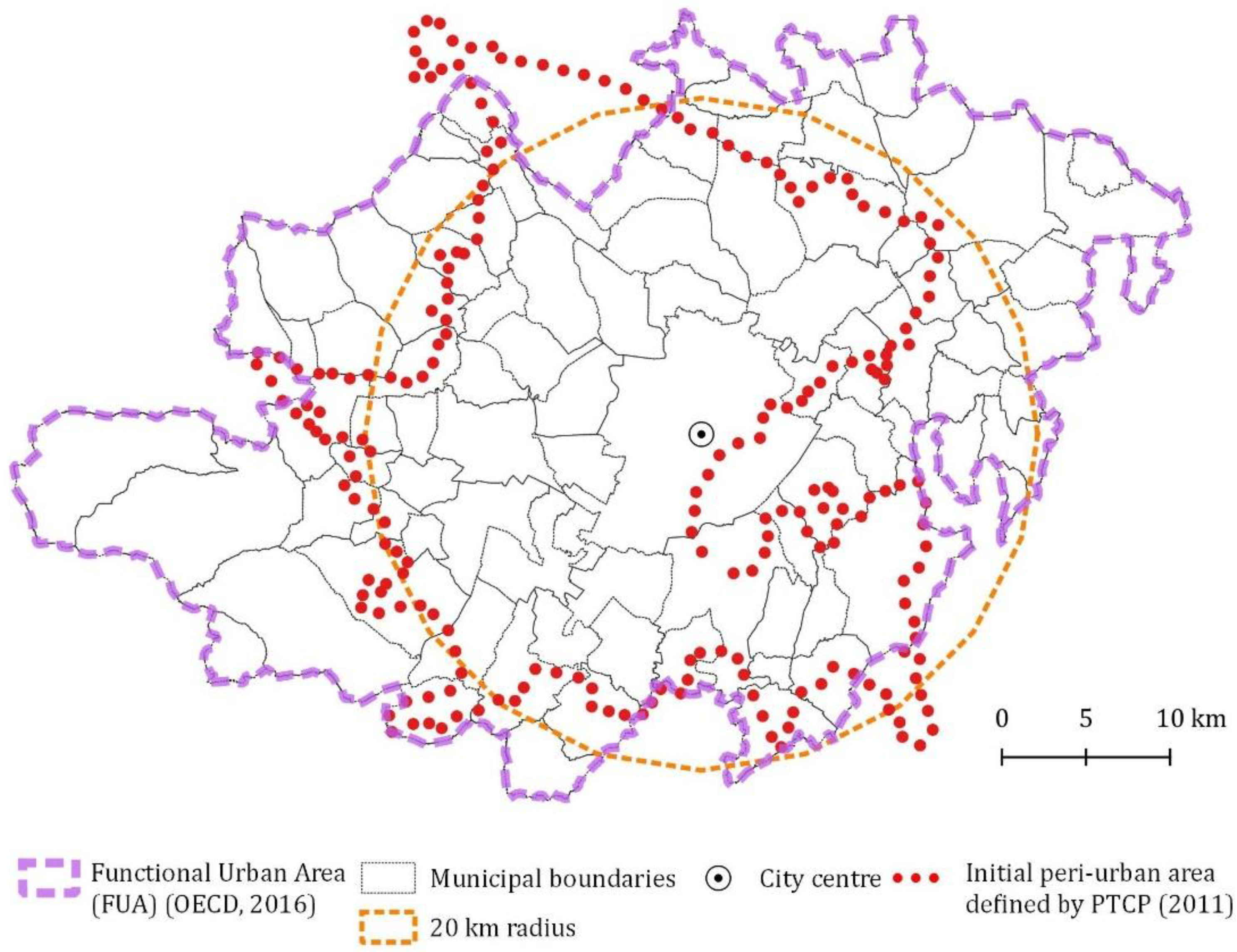
  • Identifying essential conditions for peri-urbanization: They represent the limits within which a system of material and immaterial relations and connections with the conurbation is clearly recognizable, i.e., belonging to the Functional Urban Area (FUA) [17] and, in the case of the Turin area, being no farther than 20 km from the urban center. These criteria were adopted on the basis of similar cases in the literature [29] and constitute the maximum limit, i.e., the presumed peri-urban area. The conventional distance represents the maximum limit capable of guaranteeing a spatial relationship between the urban center and those who gravitate (live and work) in a specific peri-urban area.
  • Identifying primary conditions for peri-urbanization: Based on a grid of 1 km2, this phase includes the spatial analysis of the population density (inhabitants per square kilometer), the degree of urbanization (surface of built-up areas), and the infrastructural level (total length of motorways, main roads, and railways).
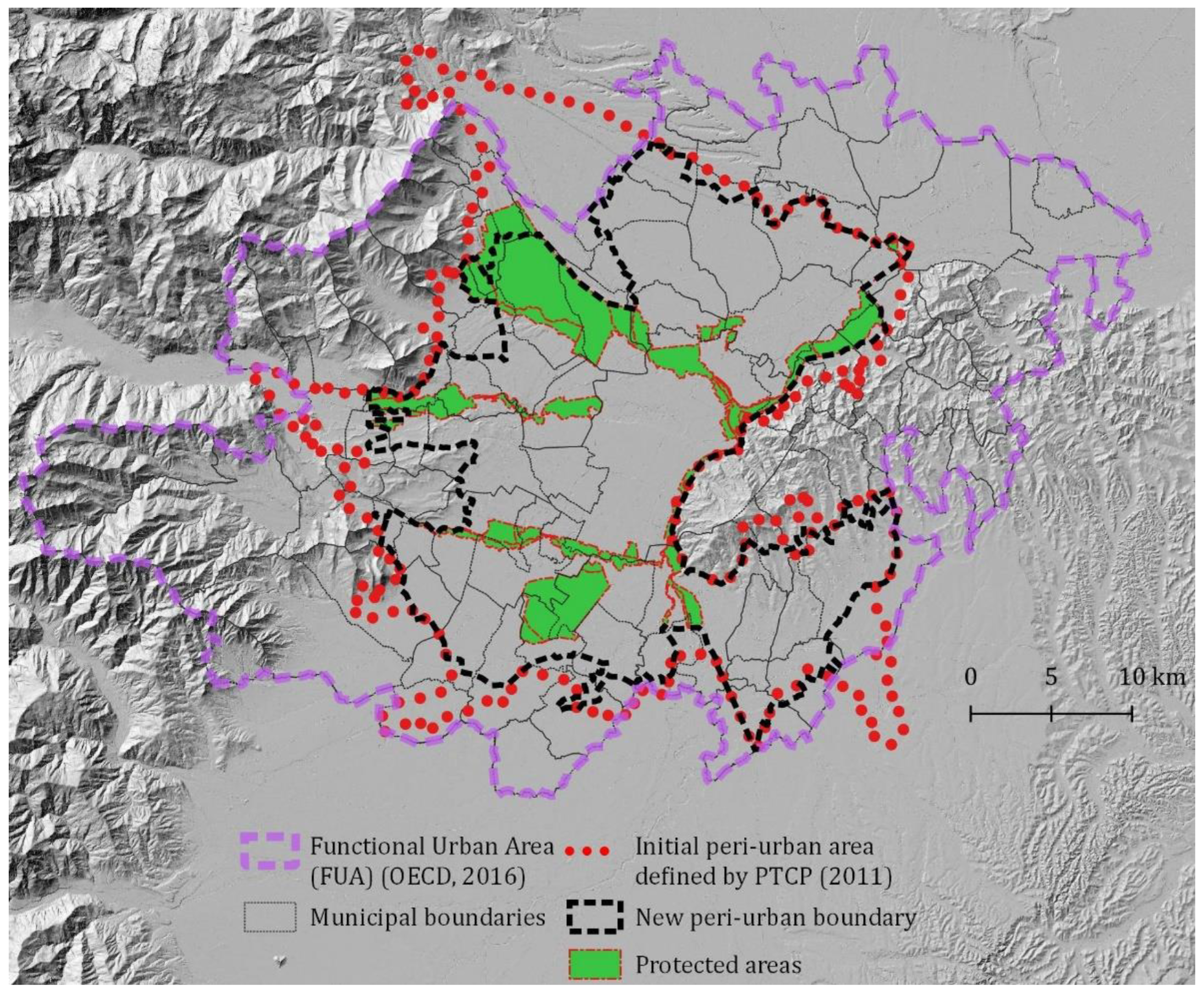
  • Identifying secondary conditions for peri-urbanization: This phase includes the analysis of the altimetry and terrain slope as possible physical barriers or natural limits of the peri-urban area It also takes into account the presence of parks and protected areas (see Section 3.2).
  • Identifying points or cells of discontinuity: Cells where at least one of the previous three conditions is not present, i.e., the cells within a radius of 15–20 km within the presumed peri-urban area. They represent the possible points of interruption and/or limitation of the peri-urban area.
  • Drawing boundaries: The discontinuity cells represent the reference trace along which the peri-urban perimeter was drawn. The perimeter was drawn in relation to the contiguity between the cells of discontinuity and physical barriers (rivers, buildings, infrastructures, etc.), i.e., following the outline of the elements closest to the possible points of interruption.
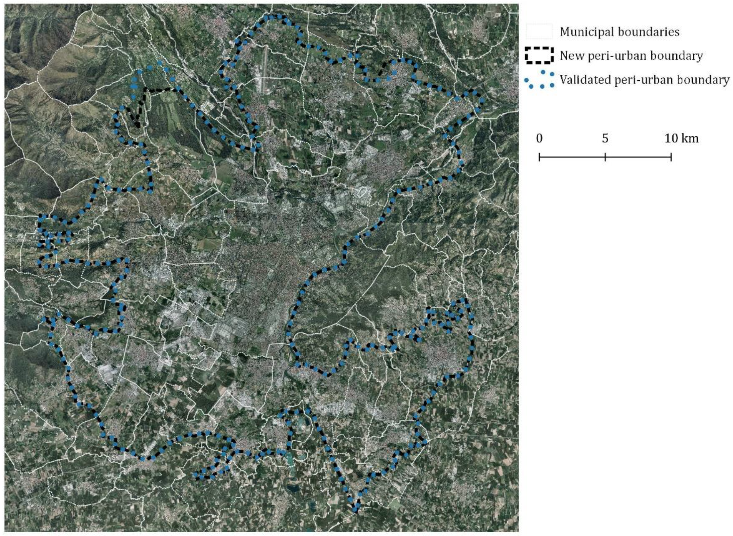
  • Stakeholder interpretation: This consists of the verification and validation of the proposed perimeter through the involvement of the main local and regional stakeholders, through one or more focus groups or round tables. In the case of the Turin area, stakeholders were selected with the help and supervision of the Metropolitan City Authority, including technicians, officials, researchers, and professionals of the main public authorities that are involved in the Turin area. Other possible and desirable stakeholders, such as residents, community leaders, etc., were not involved at this stage as they were already engaged in the general planning process of the new territorial plan (PTGM).

2.3. Definition of Rules and Guidelines for Peri-Urban Areas

This phase includes the definition of guidelines and recommendations, aimed at being included in the General Territorial Plan (PTGM) of the Turin metropolitan Area (TMA), with the help of roundtables, local stakeholders, and technical discussions with the Turin metropolitan authority, taking into account the existing values and guidelines in regional strategic plans and projects. It also defines a list of methodological steps, essays, documents, and maps needed to design a scheme of peri-urban open spaces at the local scale, identifying action plans such as agro-urban projects, agricultural parks, and integrated financial tools at local and supra-local levels. Recommendations also concern the identification of the spatial priorities and objectives to be implemented through urban planning instruments, programs, and projects or integrated action plans, as well as the regulations collected in the PTGM, with a special focus on peri-urban open spaces. The guidelines include objectives, main recommendations, the possible spatial instruments to be adopted to achieve the objectives, and target areas, i.e., the priority areas where this strategy should be applied.

3. Results

3.1. The Peri-Urban Areas in the Current Planning Documents in the TMA

The Italian territory is densely urbanized as a consequence of urban growth, which incorporates a pre-existing fabric of historic centers and rural settlements with local identities. These areas are autonomous municipalities resulting from a notable administrative fragmentation. Consequently, peri-urban areas are under the government of different municipalities. At the supra-local scale, both metropolitan cities (created in 2015) and regions have spatial planning powers, as well as competence on environmental issues and rural policies. In Piedmont, the peri-urban areas are recognized by both of these bodies.
At the regional scale, since 2011, the Regional Territorial Plan (RTP) protects fertile soils from urban development. Several articles of the Regional Landscape Plan (2017) have planning implications for the peri-urban open spaces: The protection of forest and woodland, the maintenance of ecological permeability and agronomic and landscape values, the conservation of historic rural heritage, settlements, and infrastructures, the protection and enhancement of the landscape connection networks, and the management of visual obstructions and detractions. Furthermore, the RLP proposes a specific strategy for peri-urban areas, the “Redevelopment of the urban and peri-urban context”, with the following objectives: The revitalization of fringe areas and built-up areas without a clear identity, the rationalization of new settlements and infrastructures, the upgrading of interstitial and peri-urban agricultural areas—by limiting soil consumption, as well as defining urban edges and open spaces—and the mitigation of settlement pressure and anthropogenic impacts of urbanization (pollutants, emissions, etc.).
Another initiative at the regional level is the “Green Crown” (Corona Verde) project, which has been carried out in several steps by the Territorial Regional Authority since 2001 [30]. This project concerns a multifunctional network of blueways and greenways, i.e., the green infrastructure of TMA, with the aim of enhancing the landscape quality of open spaces and their multifunctional role. It includes four strategies: Qualifying urban edges and gates, ecological de-fragmentation, fostering multifunctional agriculture, and enhancing landscape heritage and local identities by improving recreational opportunities. The strategic planning process was carried out through financial incentives for public interventions (exceeding EUR 30 million of the European Regional Development Fund), a multilevel and multisectoral governance system, and a spatial strategic plan. This process produced a new image of the TMA and a community of heritage built upon the new blue-green infrastructure. In 2021, the Piedmont Regional Authority has launched a new phase of the Green Crown project, which focuses on the governance system and is based on the green transition necessary in order to achieve the sustainable development and green economy targets of the TMA.
At the metropolitan level, in 2001 (revised in 2011), the Province of Torino Authority introduced the Provincial Territorial Plan (PTCP2), which identified the green system and the ecological network of the metropolitan area. It is based on a system of land use rules that prevent soil sealing and the urbanization of open land, allowing new development in “dense urbanized areas” only. In 2011, the revised PTCP2 also established the protection of the “free areas” from any form of building development, imposing specific rules for dense and transition areas, in order to limit the consumption of agricultural land. In this phase of the PTCP2, the need for specific guidelines on peri-urban areas was announced.
In 2021, the Metropolitan City of Torino launched the General Territorial Plan of the metropolitan area (PTGM) (draft version), which entails rules (art. 44) and guidelines for peri-urban open space. In addition, the PTGM introduced new land use rules with relevant implications for peri-urban areas such as the system of green and blue infrastructures and ecological corridors, the river and lake management contracts, protected areas, contiguous areas, areas for nature conservation, and Natura 2000 sites. In this framework, the contribution of the present study was the definition of guidelines for peri-urban open spaces, along with an unambiguous definition of their spatial boundaries, for the sake of the regulatory power of the PTGM.

3.2. Defining the Turin Peri-Urban Area

The peri-urban area of Turin was first defined by art. 34 of the technical implementation rules of the Provincial Territorial Plan in 2011 (Figure 1). Although the designation of the peri-urban area started from an empirical process at the supra-local level, the criteria for defining the boundaries were not specified in the planning documents. Its designation, carried out more than 10 years ago, needed an update. Moreover, it was strictly related to a negative vision of peri-urban areas as places characterized by conflictual uses, detrimental objects, and fragmented habitats [31], whereas the new proposed approach (and consequent definition) stress their potential as multifunctional spaces.
In order to redefine the perimeter of Turin’s peri-urban area, the existing administrative boundaries, such as the municipalities, were also examined. The Turin peri-urban area has been defined by considering the Functional Urban Area (FUA) and a distance from the urban center, which does not exceed 20 km, intended as a maximum limit able to ensure a spatial relationship between the urban center and urban users. After the identification of the presumed peri-urban area, the cells with a population density higher than 40 inhabitants per km2, the urbanized areas with a built-up area higher than 0.10 km2 per cell, and the cell with a network of roads higher than 2 km, have been identified, i.e., the primary conditions for peri-urbanization (Figure 2).
The following identification of the cells where there is no coexistence between these three conditions, within a radius of 15–20 km from the city center and in the presumed peri-urban area, allowed the designation of the interruption points and cell limits of the Turin peri-urban area (Figure 3). The cells considered physical barriers such as mountain or foothill areas (>700 a.s.l.) and hilly areas with a high slope, which have been excluded. Instead, the discontinuity cells within regional protected areas have been considered in the designation of the new boundary of the Turin peri-urban area. Regional protected areas can even partially fall within the Turin peri-urban border, but they are of fundamental importance for recreational activities and leisure, as green infrastructures for the supply of essential ecosystem services, and for the maintenance of environmental continuity between urban and rural green areas. Regarding the discontinuity cells (without peri-urbanization conditions) included in a radius of fewer than 15 km, they have been considered part of the peri-urban perimeter due to the proximity to the urban center. The new perimeter of the Turin peri-urban area was traced considering the contiguity between discontinuity cells and physical barriers (rivers, buildings, infrastructures, etc.), as well as the proximity to possible interruption points (Figure 4).
This perimeter was subsequently examined with the help of a focus group, involving 12 technicians and officials from different regional and metropolitan departments (Environment, Agriculture, Territory, and Landscape), the City of Turin (Urban Planning and Public Green Spaces), representatives of the management of protected areas, researchers, and professionals. The stakeholders were asked to give their opinion on the elements that define what peri-urban is and is not, as well as the relevance of the characters to be mapped for the identification of peri-urban open spaces. This phase produced the subsequent adjustment of the Turin peri-urban perimeter, in particular, according to some observations regarding the protected areas in the north-west of the TMA (Figure 5).
With respect to the existing perimeter, previously defined within the PTCP2, the new peri-urban area excludes the lower Canavese, the lower Val di Susa, and the Val Sangone areas. These are considered mountain and foothill areas (see criteria of secondary conditions). To the south-west and south-east, the new perimeter excludes part of the municipalities of Airasca, Piossasco, and Poirino as these exceed the 20 km limit from the urban center. The east area essentially follows the existing boundary but excludes the Turin hills. The new perimeter includes agricultural areas, forested areas, urban green areas, protected areas, and urbanized areas (built-up areas, buildings, and infrastructures), as well as built-up areas that constitute urban or rural margins, on the basis of the criteria illustrated in the previous section.

3.3. Governing the Turin Peri-Urban Area: The “Guidelines for Peri-Urban Open Spaces”

In 2011, the Provincial Territorial Plan (PTCP2) already envisaged the need to provide guidelines for peri-urban areas with the general aim of supporting the identification of homogeneous sub-areas, as well as criteria to be adopted for spatial planning. However, in line with the regional directives, the maintenance of open spaces and soil permeability are the real targets of the metropolitan land use policies in Turin due to their scarcity. Open spaces and soil permeability are non-reproducible resources that support numerous ecosystem functions such as food provision, the regulation of the water cycle, the mitigation of heat islands, the support for biodiversity and ecological connectivity, open-air recreational services (especially near densely populated areas), and the preservation of traditional landscape features and scenic landscape. For these reasons, the guidelines for open spaces in the Turin peri-urban area were designed to maintain and enhance the multifunctionality of the agro-ecosystem, preserve the elements and connectivity of the ecological network, redefine urban fringes and access, mitigate the visual impacts caused by infrastructures and built-up areas, optimize ecosystem services, and improve accessibility for recreational purposes (see Table 3).
As described in Section 3.1, the PGTM (2021, draft) addresses open peri-urban spaces by art. 44, and by two annexes, one devoted to the criteria for identifying the areas and their multiple values and ecosystem functions [32] and the second being guidelines for peri-urban open spaces. Both are mainly addressed to local authorities, which, in the Italian system, have to adjust their statutory plans in accordance with the PGTM. The municipal authorities in the Turin peri-urban areas should implement the guidelines using the following tools:
  • Procedural rules: They are collected in the zoning code of the PTGM and include the “Scheme for peri-urban open spaces” or a “Greening plan”. Identification and design of the green system are compulsory (also due to the several directives of the Plan related to environmental components, and possibly resulting in a Plan for the green-blue infrastructure). Municipal plans should identify existing functions and values by an assessment framework [32] and should define a spatial scheme accordingly. The scheme should include a short descriptive report of the open spaces identified and assessed for their current and potential role. It should also highlight the role of these spaces in the green infrastructure system and metropolitan green spaces at the supra-local level, in relation to their food function, historical-cultural importance, naturalness, and connectivity, as well as their scenic and recreational values. The scheme should also include the identification and spatialization of all local elements whose value is socially shared and legitimized by various representations and recognized by stakeholders. They concern agricultural areas of strategic and landscape interest, traditional farmsteads, terraces, farm roads, hedges, irrigation canals, areas of agronomic interest, and conventional and multifunctional farms. The spatial scheme should further identify urbanized areas, critical areas such as brownfield sites to be redeveloped, vacant areas and uncultivated/abandoned land, urban–rural margins, and permeable zones inside built-up areas. This scheme must also show how these issues will be preserved or improved. The municipal plans should identify the currently public urbanized areas to be converted into open spaces, through de-sealing and recovery interventions as preferable areas for environmental compensation measures.
  • Implementing instruments: They include integrated financial tools based on the multifunctionality of agriculture and incentives of European policies, as well as co-planning and cooperation tools involving different stakeholders and landscape managers operating at the supra-local scale such as environmental schemes and agreements with farmers. To implement guidelines, the municipalities can also adopt innovative models such as agricultural parks, widely described in the literature [33,34], and agro-urban projects [9]. They are based on the co-construction of land-use policies for the protection and management of peri-urban open spaces.

4. Discussion

The results of this research can be interpreted in different terms. Firstly, the working hypothesis was to define methods for the identification and regulation of peri-urban areas in a planning context, together with guidelines for its regulation. Although some parameters are context-related, the criteria adopted for the case study of the TMA could be easily replicable in different contexts. With regard to the identification of peri-urban areas, the following could be considered:
  • The spatial relationship with urban areas: The first level makes it possible to define the presumed peri-urban areas based on the distance from the city center and socio-economic flows in the hinterlands (travel to rural areas, workplaces, etc.), i.e., the FUA. However, in accordance with Reginster and Rounsevell [29], the distance depends on different sizes (large, medium, and small) of the city analyzed, while FUAs were defined only for urban areas with 500,000 inhabitants and over. Therefore, the distance can considerably vary for each case study, and, often, a spatial limit of per-urban areas (for example FUA) is not available, especially in non-metropolitan areas.
  • Population and urbanization: Several scholars have defined the limits related to inhabitants per square kilometer, the surface of built-up areas, and the total length of transport infrastructure in peri-urban areas. According to Piorr et al. [8] (p. 10), peri-urban areas include “settlements of less than 20,000, with an average density of at least 40 persons per km2 (averaged over 1 km2 cells)”. However, these indicators should be defined considering the local socio-economic conditions of each investigated area through expert estimations.
  • Secondary conditions and validations: Physical barriers and any other indicator to be considered in the process of identification of boundaries should be discussed and validated by the involvement of different local stakeholders and authorities.
Procedural and implementation rules for peri-urban open spaces depend on planning systems and were defined considering the most common issues in peri-urban areas. However, this method requires spatial information, a preliminary stage of identification of the landscape values [32], and the involvement of stakeholders, which may be barriers to be taken into account.
The method and tools developed in this study could be also applied in the interpretation and classification of the urban–rural interface, especially in relation to the eligibility of peri-urban areas for the implementation of some European policy targets and Structural Funds such as the Green Deal and Common Agricultural Policy. There is no single classification or approach to the urban–rural interface. According to Goncalves et al. [13] there is not just one form of urban–rural interface, but rather a multiplicity of different peri-urban types. They require a transdisciplinary approach that takes into account not only the physical, economic, and social components but also the point of view of the stakeholders, i.e., those who live in peri-urban areas [13]. Furthermore, according to Akimowicz et al. [35], land-use regulations, such as we proposed for the case study of Turin, are not enough without the presence and support of all actors involved in the agri-food chain.
Finally, this method could also be applied to a polycentric system, even combined with other methods for the delimitation of sub-centers [36]. An urban-rural region, such as the TMA, consists of a complex system of urban and peri-urban areas, i.e., a “polycentric agglomeration of settlements (…) surrounded by a rural hinterland”[8] (p. 25), that requires a specific identification and regulation.

5. Conclusions: The Crucial Role of the Landscape Approach in the Planning of Peri-Urban Areas

The Turin case study showed the political demand for planning measures on per-urban areas, due to a number of policy goals in different domains (soil, food, climate, landscape, green infrastructure, and recreation being among the keywords of planning documents). While at the municipal level, many peri-urban spaces are perceived as marginal and fragments, at the supra-local scale, they are often recognized as components of ecological networks and green infrastructures. The case study of Turin showed that the role of a metropolitan authority (or intermediate territorial agency) such as the Turin Metropolitan City can therefore be relevant for peri-urban areas due to its overall vision and multidisciplinary competences (environmental, territorial, economic issues, etc.). This research also highlighted that without an overall vision, the risk is that efforts to improve peri-urban areas create limited and sectorial effects. The landscape approach has already been proven capable of providing a meeting point. In the context of the European Landscape Convention, landscape planning is not “making plans”, but is a process of identifying the people’s aspirations, defining quality objectives, and consequently “strongly forward-looking actions”. Based on Kristensen and Primdahl [37], we can define a process of landscape strategy making as the union of collaborative governance and place making. A planning practice that addresses both conflict management and providing benefits is important. The regulatory action of spatial plans, which define specific measures to avoid the degradation of soils, habitats, and landscapes, needs to be supported by active strategies to involve farmers, cultural heritage managers, and the business world, in order to foster collaborative governance, participation, and information.

Author Contributions

Conceptualization: All authors; methodology: All authors; validation: C.C. and F.L.; formal analysis: E.G.; investigation: E.G.; data curation: E.G.; writing—original draft preparation: E.G. and C.C.; writing—review and editing: All authors; visualization: E.G.; supervision: C.C. and F.L.; project administration: F.L.; funding acquisition: F.L. All authors have read and agreed to the published version of the manuscript.

Funding

This research was funded by Città Metropolitana di Torino.

Data Availability Statement

Some publicly available datasets were analyzed in this study. Some of the new data created in this study are not publicly available due to restrictions. They are available from the corresponding author with the permission of the Turin Metropolitan Area Authority. The website of the PTGM includes some of these data and maps. See: http://www.cittametropolitana.torino.it/cms/territorio-urbanistica/ufficio-di-piano/proposta-tecnica-preliminare-di-ptgm/proposta-tecnica-preliminare-di-ptgm (accessed on 24 November 2022).

Acknowledgments

The authors would like to thank Simonetta Alberico, Paola Vayr, and Gabriele Bovo (Turin Metropolitan Area Authority), as well as all stakeholders involved in the focus group of the research project for their valuable contributions and discussion.

Conflicts of Interest

The authors declare no conflict of interest. The funders had no role in the design of the study; in the collection, analyses, or interpretation of data; in the writing of the manuscript; or in the decision to publish the results.

References

  1. Dadashpoor, H.; Ahani, S. Explaining objective forces, driving forces, and causal mechanisms affecting the formation and expansion of the peri-urban areas: A critical realism approach. Land Use Policy 2021, 102, 105232. [Google Scholar] [CrossRef]
  2. Eurostat. Applying the Degree of Urbanisation. A Methodological Manual to Define Cities, Towns and Rural Areas for International Comparisons; Publications Office of the European Union: Luxembourg, 2021. [Google Scholar]
  3. Simon, D. Urban environments: Issues on the peri-urban fringe. Annu. Rev. Environ. Resour. 2008, 33, 167–185. [Google Scholar] [CrossRef]
  4. Sieverts, T. Cities without Cities: An Interpretation of the Zwischenstadt; Spon Press Taylor & Francis Group: Abingdon, UK, 2003. [Google Scholar] [CrossRef] [Green Version]
  5. Davoudi, S.; Stead, D. Urban-rural relationships: An introduction and a brief history. Built Environ. 2002, 28, 269–277. [Google Scholar]
  6. Fanfani, D. Il governo del territorio e del paesaggio rurale nello spazio “terzo” periurbano. Il parco agricolo come strumento di politiche e di progetto, Ri_vista. Ric. Per La Progett. Del Paesaggio 2006, 6, 54–69. [Google Scholar]
  7. Busck, A.G.; Kristensen, S.P.; Præstholm, S.; Reenberg, A.; Primdahl, J. Land system changes in the context of urbanisation: Examples from the peri-urban area of Greater Copenhagen. Dan. J. Geogr. 2006, 106, 21–34. [Google Scholar] [CrossRef]
  8. Piorr, A.; Ravetz, J.; Tosics, I. (Eds.) Peri-Urbanisation in Europe. In Towards a European Policy to Sustain Urban-Rural Futures; Synthesis Report; University of Copenhagen/Academic Books Life Sciences: Copenhagen, Denmark, 2011. [Google Scholar]
  9. Gottero, E. (Ed.) Agrourbanism. In Tools for Governance and Planning of Agrarian Landscape, GeoJournal Library; Springer: Cham, Switzerland, 2019; Volume 124. [Google Scholar]
  10. Vejre, H.; Eiter, S.; Hernandez-Jimenez, V.; Lohrberg, F.; Loupa-Ramos, I.; Recasens, X.; Pickard, D.; Scazzosi, L.; Simon-Rojo, M. Can agriculture be Urban? In Urban Agriculture Europe; Lohrberg, F., Licka, L., Scazzosi, L., Timpe, A., Eds.; Jovis Verlag: Berlin, Germany, 2016; pp. 18–21. [Google Scholar]
  11. Mortoja, M.G.; Yigitcanlar, T.; Mayere, S. What is the most suitable methodological approach to demarcate peri-urban areas? A systematic review of the literature. Land Use Policy 2020, 95, 104601. [Google Scholar] [CrossRef]
  12. Moreira, F.; Fontes, I.; Dias, S.; Silva, J.B.E.; Loupa-Ramos, I. Contrasting static versus dynamic-based typologies of land cover patterns in the Lisbon metropolitan area: Towards a better understanding of peri-urban areas. Appl. Geogr. 2016, 75, 49–59. [Google Scholar] [CrossRef]
  13. Goncalves, J.; Castilho Gomes, M.; Ezequiel, S.; Moreira, F.; Loupa-Ramos, I. Differentiating peri-urban areas: A transdisciplinary approach towards a typology. Land Use Policy 2017, 63, 331–341. [Google Scholar] [CrossRef]
  14. Cattivelli, V. Institutional Methods for the Identification of Urban and Rural Areas—A Review for Italy. In Smart and Sustainable Planning for Cities and Regions. Results of SSPCR 2019; Bisello, A., Vettorato, D., Ludlow, D., Baranzelli, C., Eds.; Springer Science and Business Media: Berlin, Germany, 2021; pp. 187–207. [Google Scholar]
  15. Allen, A. Environmental planning and management of the peri-urban interface: Perspectives on an emerging field. Environ. Urban. 2003, 15, 135–147. [Google Scholar] [CrossRef] [Green Version]
  16. Organization for Economic Co-operation and Development (OECD). OECD Regional Typology; Directorate for Public Governance and Territorial Development: Paris, France, 2011; Available online: https://www.oecd.org/cfe/regionaldevelopment/OECD_regional_typology_Nov2012.pdf (accessed on 24 November 2022).
  17. Organization for Economic Co-operation and Development (OECD). Definition of Functional Urban Areas (FUA) for the OECD Metropolitan Database; Directorate for Public Governance and Territorial Development: Paris, France, 2013; Available online: https://www.oecd.org/cfe/regionaldevelopment/Definition-of-Functional-Urban-Areas-for-the-OECD-metropolitan-database.pdf (accessed on 12 November 2022).
  18. Dijkstra, L.; Poelman, H. A Harmonized Definition of Cities and Rural Areas: The New Degree of Urbanisation; Regional Working Paper, Produced by the Directorate-General for Regional and Urban Policy, WP 01. 2014. Available online: https://ec.europa.eu/regional_policy/sources/work/2014_01_new_urban.pdf (accessed on 24 November 2022).
  19. Aguilera, F.; Valenzuela, L.M.; Botequilha-Leitão, A. Landscape metrics in the analysis of urban land use patterns: A case study in a Spanish metropolitan area. Landsc. Urban Plan. 2011, 99, 226–238. [Google Scholar] [CrossRef]
  20. Cattivelli, V. Planning peri-urban areas at regional level: The experience of Lombardy and Emilia-Romagna (Italy). Land Use Policy 2021, 103, 105282. [Google Scholar] [CrossRef]
  21. Dadashpoor, H.; Somayeh, A. Land tenure-related conflicts in peri-urban areas: A review. Land Use Policy 2019, 85, 218–229. [Google Scholar] [CrossRef]
  22. Liu, Z.; Robinson, G.M. Residential development in the peri-urban fringe: The example of Adelaide, South Australia. Land Use Policy 2016, 57, 179–192. [Google Scholar] [CrossRef]
  23. Science for Environment Policy. No Net Land Take by 2050? Future Brief 14; Produced for the European Commission DG Environment by the Science Communication Unit; UWE: Bristol, UK, 2016. [Google Scholar]
  24. European Environment Agency (EEA). Urban Sprawl in Europe, Joint EEA-FOEN Report; Publications Office of the European Union: Luxembourg, 2016. [Google Scholar]
  25. Brinkley, C. High rugosity cities: The geographic, economic and regulatory pathology of America’s most non-concentric urban areas. Land Use Policy 2018, 73, 215–224. [Google Scholar] [CrossRef]
  26. Maye, D.; Keech, D.; Knickel, M.; Wiskerke, H.; Reed, M. ROBUST Deliverable 3.3. Synthesis Report; Funded from the European Union’s Horizon 2020 Research and Innovation Programme under Grant Agreement No 727988. 2021. Available online: https://cordis.europa.eu/project/id/727988/results (accessed on 24 November 2022).
  27. Amirinejad, G.; Donehue, P.; Baker, D. Ambiguity at the peri-urban interface in Australia. Land Use Policy 2018, 78, 472–480. [Google Scholar] [CrossRef]
  28. Hedblom, M.; Andersson, E.; Borgström, S. Flexible land-use and undefined governance: From threats to potentials in peri-urban landscape planning. Land Use Policy 2017, 63, 523–527. [Google Scholar] [CrossRef]
  29. Reginster, I.; Rounsevell, M. Scenarios of future urban land use in Europe. Environ. Plan. B Plan. Des. 2006, 33, 619–636. [Google Scholar] [CrossRef]
  30. Cassatella, C. The “Corona Verde” Strategic Plan: An integrated vision for protecting and enhancing the natural and cultural heritage. Urban Res. Pract. 2013, 6, 219–228. [Google Scholar] [CrossRef]
  31. Socco, C.; Cavaliere, C.; Guarini, S.M.; Montrucchio, M. La Natura Nella Città. In Il Sistema Verde Urbano e Periurbano; Francoangeli: Milan, Italy, 2005. [Google Scholar]
  32. Gottero, E.; Cassatella, C.; Larcher, F. Planning peri-urban open spaces: Methods and tools for interpretation and classification. Land 2021, 10, 802. [Google Scholar] [CrossRef]
  33. Fanfani, D.; Matarán Ruiz, A. Bioregional Planning and Design: Volume I; Springer: Cham, Switzerland, 2020. [Google Scholar]
  34. Fanfani, D. Agricultural Park in Europe as Tool for Agri-Urban Policies and Design: A Critical Overview. In Agrourbanism. Tools for Governance and Planning of Agrarian Landscape; Gottero, E., Ed.; Springer: Cham, Switzerland, 2019; pp. 149–169. [Google Scholar]
  35. Akimowicz, M.; Cummings, H.; Landman, K. Green lights in the Greenbelt? A qualitative analysis of farm investment decision-making in peri-urban Southern Ontario. Land Use Policy 2016, 55, 24–36. [Google Scholar] [CrossRef]
  36. Roca Cladera, J.; Marmolejo Duarte, C.R.; Moix, M. Urban structure and polycentrism: Towards a redefinition of the sub-centre concept. Urban Stud. 2009, 46, 2841–2868. [Google Scholar] [CrossRef]
  37. Kristensen, L.S.; Primdahl, J. Landscape strategy making as a pathway to policy integration and involvement of stakeholders: Examples from a Danish action research programme. J. Environ. Plan. Manag. 2020, 63, 1114–1131. [Google Scholar] [CrossRef]
Figure 1. Identifying indispensable conditions for peri-urbanization in the TMA.
Land 12 00217 g001
Figure 2. Identifying primary conditions for peri-urbanization in the TMA.
Land 12 00217 g002
Figure 3. The perimeter of the Turin peri-urban area defined in relation to the discontinuity cells within the presumed peri-urban area and taking into account the proximity to the city center (buffer 15 km).
Land 12 00217 g003
Figure 4. The perimeter of the Turin peri-urban area in relation to the discontinuity cells within protected areas and taking into account the altimetry and the terrain slope (secondary conditions for peri-urbanization).
Land 12 00217 g004
Figure 5. The perimeter of the Turin peri-urban area after the stakeholders’ validation.
Land 12 00217 g005
Table 1. Policy documents/plans analyzed.
Policy Document/PlanScaleProducer AuthorityYearSource
Regional Territorial Plan (RLP)regionalRegion Authority2011https://www.regione.piemonte.it/web/temi/ambiente-territorio/territorio/piano-territoriale-regionale-ptr (accessed on 24 November 2022)
Regional Landscape Plan (RLP)regionalRegion Authority2017https://www.regione.piemonte.it/web/temi/ambiente-territorio/paesaggio/piano-paesaggistico-regionale-ppr (accessed on 24 November 2022)
Green Crown projectsupralocalRegion Authority2001
(revised in 2007)
https://www.regione.piemonte.it/web/temi/ambiente-territorio/ambiente/corona-verde (accessed on 24 November 2022)
Provincial Territorial Plan (PTCP2)metropolitanProvince of
Torino Authority
2011http://www.cittametropolitana.torino.it/cms/territorio-urbanistica/pianificazione-territoriale/ptc2-vigente (accessed on 24 November 2022)
General Territorial Plan (PTGM)—draft versionmetropolitanMetropolitan
City of Turin
2021http://www.cittametropolitana.torino.it/cms/territorio-urbanistica/ufficio-di-piano (accessed on 24 November 2022)
Table 2. Collected geospatial data.
DataProducer, YearSource
Functional Urban Area[17]https://www.oecd.org/regional/regional-statistics/functional-urban-areas.htm (accessed on 18 May 2022)
Population density (inhabitants per square kilometre)ISTAT, 2011https://www.istat.it/it/archivio/104317 (accessed on 24 November 2022)
Surface of built-up areasMetropolitan City of Turin, 2021http://www.cittametropolitana.torino.it/cms/risorse/territorio/dwd/ptgm/ptpp/a_rel_ill/a1_quaderni/007_Quad_Periurbano.pdf (accessed on 24 November 2022)
Total length of motorways, main roads, railways
Altimetry
Protected areasPiedmont Region Authority, 2021https://www.regione.piemonte.it/web/temi/ambiente-territorio/biodiversita-aree-naturali/parchi/dati-alfanumerici-geografici-aree-protette (accessed on 18 May 2022)
Table 3. Guidelines for open spaces in the Turin peri-urban area.
ObjectiveMain RecommendationsToolsTarget Areas
Preventing land take and soil sealingprotecting areas of agronomic interesttransfer of building capacityAreas of agronomic interest
preserving permeability and openings Building regulationVacant, derelict, degraded and abandoned areas; uncultivated areas;
Defining green beltsagro-urban policies at inter-municipal scaleurban-rural fringe
Defining agricultural parksagro-urban policies at inter-municipal scale,
agreements with farmers for management
urban-rural fringe
Encouraging the permanence of farms and local food productionagreements with farmers for promotion of local agri-food productsagricultural areas of strategic landscape interest
Reclaiming brownfield and degraded areasPromoting de-sealing through Nature-based solutions (NBS) tax incentives, building bonusesIntra-urban areas
Reclaiming brownfield sites and polluted sitestax incentives, building bonusesderelict, degraded and abandoned areas
Restoring soil function and non food functions through NBSBuilding and zooning regulationderelict, degraded and abandoned areas
Promoting visual mitigations through plants, NBS and urban forestry agreements with farmers for managementIntra-urban areas, urban-rural fringe
Fostering multifunctional and social agriculturePromoting Urban Food gardening tax incentives, Building regulationIntra-urban areas, peri-urban open spaces
Identifying multifunctional and urban oriented farms Procedural rulesIntra-urban areas, peri-urban open spaces
Identifying and promoting redevelopment of traditional and historical farm buildingsProcedural rules, Building regulationIntra-urban areas, peri-urban open spaces,
Agricultural areas of strategic landscape interest
Promoting direct sale on the farm and proximity farming through farmers marketBuilding regulation;
agreements with farmers for promotion of local agri-food products
Intra-urban areas, peri-urban open spaces
Improving naturality and environmental qualitymaintaining and enhancing green infrastructure through NBStax incentives,
zoning regulation
peri-urban open spaces, Ecological corridors
increasing public and private green spacesBuilding regulation,
tax incentives
Intra-urban areas,
Renaturalisation of minor river banksSubsidies, agreements with farmers for managementperi-urban open spaces, Ecological corridors
promoting and encouraging sustainable and/or organic farming practicesagreements with farmers for managementperi-urban open spaces
Defining green plans and regulationsProcedural rulesUrban and peri-urban municipalities
Encouraging the maintenance of permanent grassland and the creation and/or management of grass stripsSubsidies, agreements with farmers for managementperi-urban open spaces, Ecological corridors
Protecting traditional rural landscape featuresIdentifying historical and traditional landscape components Procedural rulesperi-urban open spaces
Identifying and promoting redevelopment of traditional and historical rural buildingsProcedural rules, Building regulationperi-urban open spaces
Defining rural areas regulations and prohibiting interventions that may alter the character of the landscapeProcedural rules, regulations peri-urban open spaces
Identifying uncultivated or abandoned agricultural landProcedural rulesperi-urban open spaces
Removing or mitigating visual impactsIdentifying existing or potential visual interferenceProcedural rulesperi-urban open spaces
Removing occlusions in panoramic viewpointsRegulation, agreements with farmers/local enterprise/private sector for implementation and managementperi-urban open spaces
Implementing visual mitigation measuresagreements with farmers/local enterprise/private sector for implementation and managementurban-rural fringe
Qualifying urban edgesdelimiting urbanised area, identifying vacant areas and designing urban fringesProcedural rulesurban-rural fringe
Designing agricultural areas of strategic landscape interest (non-building areas)Regulation urban-rural fringe
Strengthening recreational networksEnhancing the existing soft mobility network and improving services and infrastructures for slow tourismagreements with farmers for implementation and managementIntra-urban areas, peri-urban open spaces
Improving accessibility of tourist destinations and landmarks Regulation, agreements with farmers for implementation and managementperi-urban open spaces
Creating greenway, cultural pathways and quiet-lanes agreements with farmers for implementation and managementperi-urban open spaces
Creating and strengthening green recreational spacesProcedural rulesIntra-urban areas, peri-urban open spaces
Disclaimer/Publisher’s Note: The statements, opinions and data contained in all publications are solely those of the individual author(s) and contributor(s) and not of MDPI and/or the editor(s). MDPI and/or the editor(s) disclaim responsibility for any injury to people or property resulting from any ideas, methods, instructions or products referred to in the content.

