Article

Evaluation, Recognition and Implications of Urban–Rural Integration Development: A Township-Level Analysis of Hanchuan City in Wuhan Metropolitan Area

1
School of Architecture and Urban Planning, Huazhong University of Science and Technology, Wuhan 430074, China
2
Hubei Engineering and Technology Research Center of Urbanization, Wuhan 430074, China
3
The Key Laboratory of Urban Simulation for Ministry of Natural Resources, Wuhan 430074, China
4
Real Estate Management Bureau, Dayabay Economic and Technological Development Zone, Huizhou 516000, China
*
Author to whom correspondence should be addressed.
Land 2023, 12(1), 14; https://doi.org/10.3390/land12010014
Submission received: 27 November 2022 / Revised: 14 December 2022 / Accepted: 19 December 2022 / Published: 21 December 2022
(This article belongs to the Special Issue Impacts of Land Use Pattern in Metropolitan Area)

Abstract

:
China has achieved success in implementing the rural revitalization strategy and promoting the development of new urbanization. However, there are still many problems in the research and implementation on urban–rural integration development, such as insufficient research at the township level, unclear recognition of development patterns, and disconnection from land-use planning. Therefore, taking Hanchuan city in the Wuhan metropolitan area as a case study, this research constructs a comprehensive evaluation system of urban–rural integration development based on both on the current and potential level of development, and identifies the spatial characteristics and patterns in the study area. This study found that: (1) The comprehensive evaluation result of urban–rural integration development in Hanchuan City shows that a high level of development units are mainly distributed in the northeast and southwest, and gradually decreases from the northeast and southwest, indicating that towns in the central area are relatively weakly driven by the radiation of the surrounding growth poles. (2) Xiannvshan Street, Makou Town, Chenhu Town, and Xinyan Town with the highest comprehensive evaluation values were selected as the centers of urban–rural integration development in four directions. (3) Four typical patterns of urban–rural integration development, which are town gathering, agro-tourism interaction, industry-trade driven, and agricultural service, are derived by the gravity model and classification assignment method according to their respective centers. (4) According to the urban–rural integration development patterns, land-use strategies such as centralization for promoting linkage level of towns, differentiation for arranging various resources and infrastructures, and demonstration for optimization of experience to the whole area are proposed in a targeted manner. This study has important implications for the preparation and implementation of urban–rural integration development and provides effective planning guidance for promoting social equity and accessibility of facilities in the metropolitan area.

1. Introduction

Urban–rural integration is considered to be the ideal state of development between urban and rural areas [1], which means that elements freely penetrate and interact with each other, and make the urban and rural develop together [2]. To overcome the negative impact of the long-term urban–rural dual system, the European Commission formulated the integration principle from the perspective of European spatial development in 1999 [3]. Nowadays, urban–rural integration has become an important trend in social and economic development for both the developed and developing countries [4,5].
Since 1949, China has implemented the urban–rural development concept of “supporting the industry with agriculture and nurturing cities with the countryside” [6], and gradually formed the situation of urban–rural dual division, leading to the problem of unbalanced urban–rural development over the past five decades. In the new era, China has paid great attention to the integrated development of urban and rural areas, such as continuously increasing the support for the rural areas and formulating a series of policies and systems to promote rural revitalization and urban–rural development. In general, China’s urban–rural relationship has gone through a process from dual segmentation to overall planning and integration [7]. However, in 2020, the urban–rural income ratio in developed countries such as the UK and Canada was close to 1, and the urban–rural income ratio in low-income countries in Africa such as Uganda was only about 2.3, while the urban–rural income ratio gap in China was as high as 2.56 [8]. The unbalanced and insufficient development between urban and rural areas is still an important feature of the current urban–rural relationship in China.
Theories regarding the interactive relationships between urban and rural mainly include Utopian socialism, Marx and Engels’ urban–rural relationship theory, “Garden city”, “Organic evacuation” theory and “Desakota” model [9,10,11,12]. They emphasize balanced development and deny excessive bias towards urban and rural areas. From the perspective of urban–rural integration development, current research mainly focuses on measuring the level of urban–rural integration [13], evolving characteristics [14], influencing factors [15,16], classification of villages in the context of urban–rural integration [17], and summarizing excellent case experiences [18,19]. In addition, related studies have concluded that there are flows of people, goods, capital, information, and technology [20] between urban and rural areas. Mayer et al. focused on rural entrepreneurs who established links between urban and rural areas and investigated the role of their entrepreneurial activities in improving economic relations between urban and rural areas [21]. However, existing studies have paid less attention to the planning responses to the integrated urban–rural development, especially on how to scientifically delineate the scope of integrated urban–rural development zones and how to propose targeted optimization strategies for different development patterns. In particular, the problems of insufficient research at the county implementation level, unclear guidance and strategy of development patterns, and disconnect from spatial planning are particularly prominent.
To fill these gaps, this research selects Hanchuan City, located within the Wuhan metropolitan area, as the study area. Then, the comprehensive evaluation system which combines the current and potential level of urban–rural integration development together is constructed. The centers of urban–rural integration development are selected according to the comprehensive level of urban–rural integration development at township level, and the urban–rural integration development zones are delineated by using the gravity model. Finally, different types of urban–rural integration development patterns are identified, and corresponding strategies for urban–rural integration development planning guidance are proposed. The innovation points of this research include the following two main aspects. Firstly, this study constructs a comprehensive evaluation system which is made up of socio-economic and land-use-related indicators, to quantitatively assess the urban–rural integration development at township level. By using the gravity model, the scope of urban–rural integration development zones are delineated. Secondly, different leading patterns of urban–rural integration development zones delineated. Furthermore, urban–rural land-use strategies, such as centralization, differentiation and demonstration, are proposed according to the recognized patterns. This research could provide a direct basis for the preparation and implementation of urban–rural integration development, thus leading to better social equity and accessibility to facilities in the metropolitan area.

2. Materials and Methods
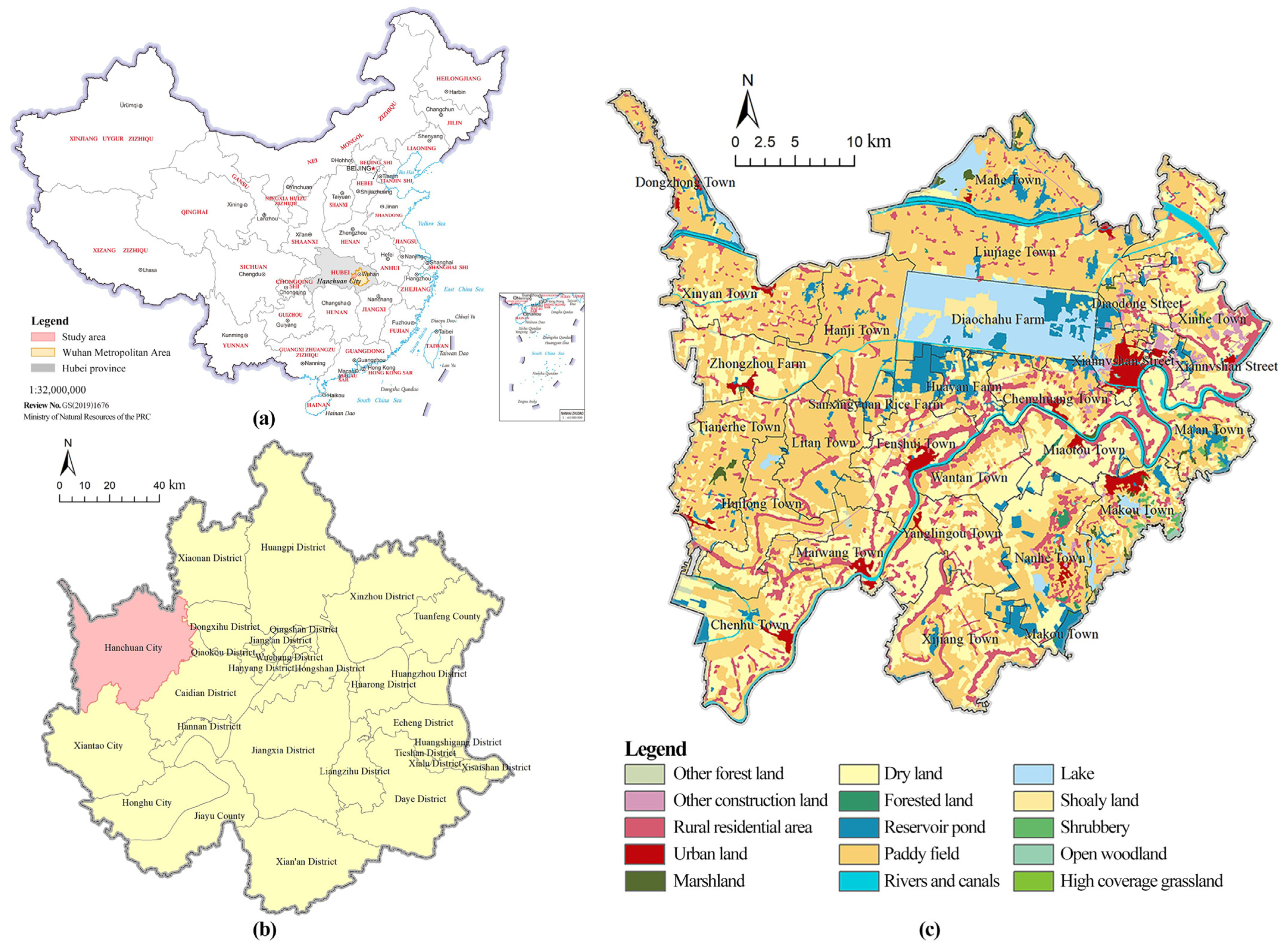
2.1. Study Area

Hanchuan City is located in the Wuhan metropolitan area in the middle reaches of the Yangtze River, with flat and low-lying terrain, low terrain complexity, and a strong agricultural foundation. Hanchuan City is a key county-level city for comprehensive agricultural development in the Jianghan Plain. Hanchuan City consists of two township-level subdistricts and 24 towns, with a total area of 1659.91 km2. The urban land area accounts for about 1.89% and the rural settlement area accounts for about 9.21%. In 2020, the GDP of Hanchuan City was 64.566 billion Yuan, the resident population was about 0.9 million, and the urbanization rate was about 60.66 %. Figure 1c shows the administrative division and land use of Hanchuan City.

2.2. Data Sources

The data used in this study mainly include socio-economic statistics, land-use data, and built environment data. Among these data, socio-economic statistics are mainly from the Xiaogan Statistical Yearbook 2020, and the China County Statistical Yearbook. The land-use data of Hanchuan is the LUCC data of 2020, provided by the Data Center for Resources and Environmental Sciences, Chinese Academy of Sciences (http://www.resdc.cn, accessed on 16 September 2022), which is now one of the most commonly used data sets for conducting related studies [22]. Spatial data of the built environment, such as road networks and transportation hubs, were obtained from the Hanchuan Planning Bureau.

2.3. Methods

In this study, the comprehensive evaluation of urban–rural integration development was a weighted combination of the current and potential levels of integration. The evaluation of current integration development level was carried out from five dimensions, including urban–rural demographic, spatial, economic, social and ecological integration. The evaluation of the potential integration development level was carried out from five dimensions, including location and transportation, town scale, economic level, facility construction, and characteristic resources. Based on the comprehensive evaluation results, towns with the highest integration level were selected as the centers of the urban–rural integration development zones in each direction within the municipal area. The gravity model was used to delineate the scope of the urban–rural integration development zones and identify the urban–rural integration development patterns. Finally, the corresponding planning and guiding strategies for urban–rural integration development were proposed in a targeted manner (Figure 2).

2.3.1. Evaluation Model of the Current Integration Development Level

The level of current urban–rural integration development measures the degree of interconnectedness of natural, spatial, economic, and social elements between urban and rural areas [23]. In this study, the linear weighted sum method was used to calculate the current urban–rural integration development level score of each town [24]. The calculation formula is as follows:
L i = j = 1 n W j X i j
where L i is the score of the level of current urban–rural integration development of the i th town; W i and X i j are the weights and standardized values of the j th indicator of the i th town, respectively; and n is the number of towns.
(1)
Construction of the Indicator System
This study fully considers the calculability of indicators, the accessibility of data, and combines the current situation and demands of urban–rural development to construct the evaluation system of urban–rural integration development. As shown in Table 1, one target is the level of urban–rural integration development, and five criteria are urban–rural population integration, spatial integration, economic integration, social integration and ecological integration. The 18 indicators are introduced to conduct the measurements and calculation (Table 1).
(2)
Data Normalizations
The units and attributes among indicators in the evaluation system are different and cannot be directly weighted and superimposed, it is necessary to standardize the evaluation indicators into a uniform manner. In this study, all data are processed by using the standardized method of extreme differences [30], which is calculated as follows:
Positive indicators:
Z i j = X i j m i n X i j m a x X i j m i n X i j
Negative indicators:
Z i j = m a x X i j X i j m a x X i j m i n X i j
where Zij is the standardized value of the jth indicator in the ith sample; Xij is the jth indicator value in the ith sample; maxXij is the maximum value of the jth indicator in the ith sample; and minXij is the minimum value of the jth indicator in the ith sample.
(3)
Weight Calculation
The standardized indicator value of each town is passed for KMO and Bartlett’s sphericity test [31]. The linear combination coefficients and the coefficients in the composite score model is calculated based on the principal component matrix. The weights of each indicator are distributed from 0 to 1, resulting in the final weight of each indicator.

2.3.2. Evaluation Model of Potential Urban–Rural Integration Development Level

Based on the standardization of data and calculation of weights, the potential development level of each town is weighted and summed, i.e., the weighted sum of the standardized values of each indicator multiplied by its weight is calculated [32]. The calculation formula is:
S i = j = 1 n w j P i j j = 1 , 2 , 3 , · · · n
where Si is the potential development score of the ith town, Pij is the standardized indicator of the ith town, w j is the weight of indicator j, and n is the number of indicators in the evaluation system.
(1)
Construction of the Indicator System
The hierarchical model of the analytic hierarchy process (AHP) is used to construct the evaluation system of potential urban–rural integration development into a structure of “1 + 5 + 18”, which consists of 1 target, 5 criteria and 18 indicators. The target is the potential level of urban–rural integration development of each town. The criteria include five aspects: location and transportation, town scale, economic level, facility construction, and characteristic resources. The 18 indicators include specific indicators such as population size, township construction scale, industrial output value, and per capita net income of farmers (Table 2).
(2)
Weight Calculation
The data for calculating the indicators are normalized using the forward processing method in Section 2.3.1. Hierarchical analysis and the Delphi method are used to determine the weights of each evaluation indicator [38]. The hierarchical structure model is established by using Yaahp software, and the weights of each indicator are finally calculated by establishing the relative importance comparison matrix of indicators after the consistency test.

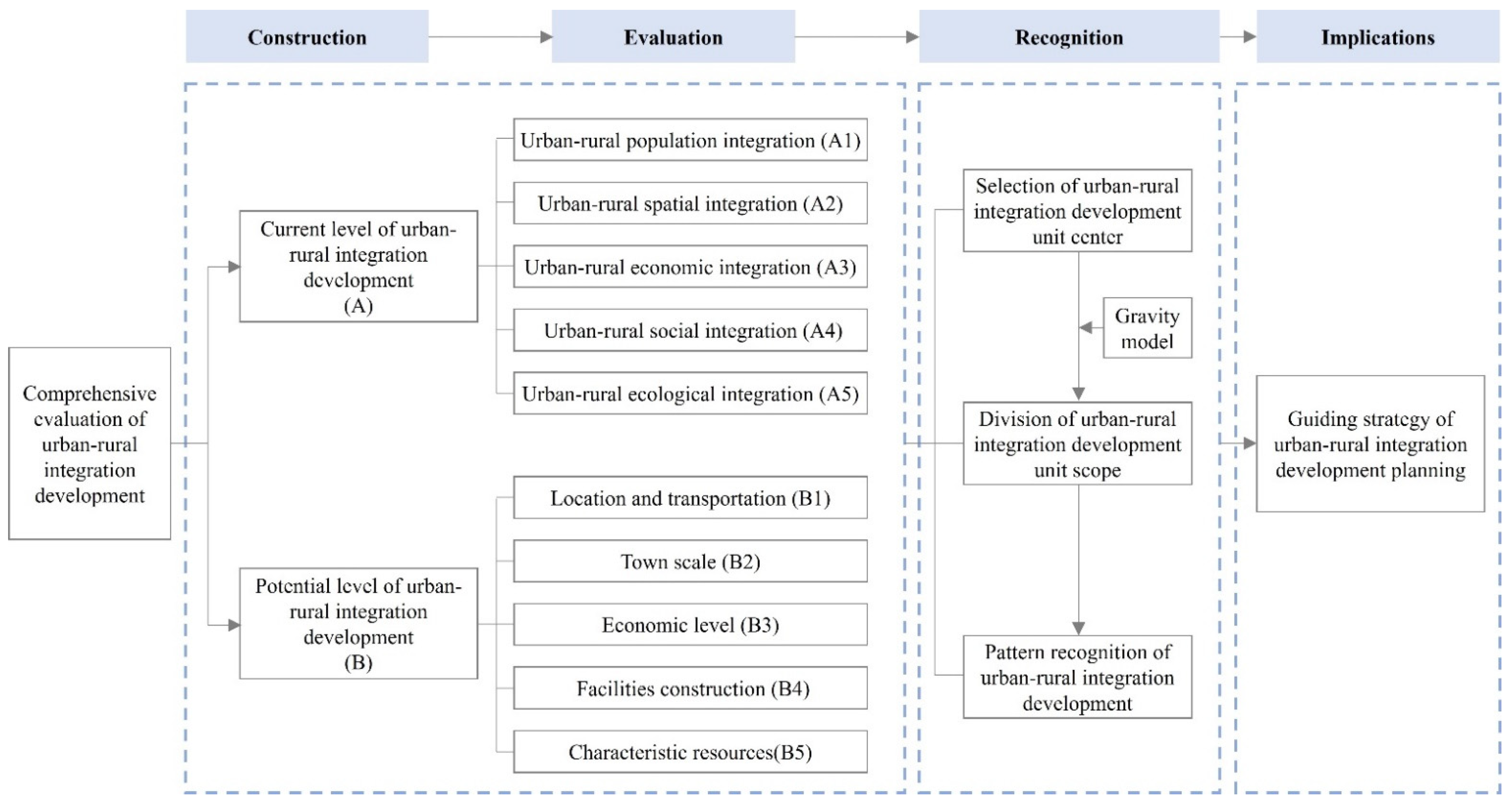
2.3.3. The Comprehensive Evaluation System of Urban–rural Integration Development

The evaluation results of the current and potential urban–rural integration development levels are weighted and summed, and the weights are calculated specifically using the expert scoring method. The revised scores of the current and potential development, and the final comprehensive evaluation results are obtained by adopting the combined opinions of several experts [39]. The specific formula is as follows:
T = a 1 L i + a 2 S i
where T is the comprehensive evaluation result of urban–rural integration development; L i and S i are the evaluation results of the current and potential urban–rural integration development level, respectively; and a 1 and a 2 are the weights of the current and potential urban–rural integration development level, respectively.

2.3.4. The Division of Urban–rural Integration Development Zones

Towns with the highest overall score are selected as the centers of the urban–rural integration development zones. The gravity model is used to calculate the gravity value between each center and the surrounding towns [40]. The higher the gravity value, the closer to the centers. In the gravity model formulation, the mass parameter and the distance parameter are key factors that affect the model’s results. The specific formula is as follows:
I i j = M i M j D i j 2
where I i j is the gravity between center i and town j ; M i and M j denote the comprehensive evaluation results of center i and town j ; and D i j denotes the road distance between i and j .

3. Results

3.1. Comprehensive Evaluation of Urban–Rural Integration Development

3.1.1. The Current Level of Urban–Rural Integration Development

The current level of most towns in Hanchuan City is lower than the average. The towns with high levels form an axis in the direction from northeast to southwest. The indicator weights of each township in Hanchuan are derived by principal component analysis, and the current level of urban–rural integration development of each town is finally calculated. The development level of urban–rural integration in Hanchuan is 0.35, which can be judged that Hanchuan as a whole is in the primary stage of urban–rural integration. Among them, 7 out of all the 26 towns, such as Xiannvshan Street and Xinhe Town, have a higher value than the average value of Hanchuan City, accounting for 26.92%. While the other 19 towns, such as Miaotou Town and Dongzhong Town, are lower than the overall average value, accounting for 73.08%. Therefore, Hanchuan City still needs to continue to promote the development of urban–rural integration.
The natural breakpoint method was used to classify the current urban–rural integration development value of 26 towns of Hanchuan City into four levels. The first category is the towns with the highest level of urban–rural integration development, accounting for 3.84% of the total towns, such as Xiannvshan Street, which is the central urban area of Hanchuan City, with a current level of urban–rural integration development far ahead of other towns. The second category is the towns with a higher level of urban–rural integration development, including Makou Town, Chenghuang Town, Fenshui Town, Chenhu Town, Xinhe Town, and Diaodong Street, accounting for 23.08% of the total. The third category is towns with a lower current level of urban–rural integration development, including eight towns, such as Maiwang Town, Tianerhe Town, and Huilong Town, accounting for 30.77% of the total towns. The fourth category is towns with the lowest current level of urban–rural integration development, including 11 townships such as Xinyan Town, Dongzhong Town, and Mahe Town, accounting for 42.31% of the total. From the viewpoint of spatial distribution, the first and second categories of towns form a spatial axis in the direction of “northeast–southwest”, which may provide strong support for determining the spatial development pattern of Hanchuan City (Figure 3).

3.1.2. Potential Level of Urban–Rural Integration Development

In order to specifically display the potential urban–rural integration development of each town, this study standardized the calculation results and uniformly set the highest value of potential urban–rural integration development of towns up to 100. According to the described method, the standardized scores of the potential urban–rural integration development of 26 towns were calculated, and the natural breakpoint method in ArcGIS software 10.0.2 was applied to classify the potential level of towns into three categories, which were high, medium and low development towns, respectively. Among them, the high development towns have comprehensive scores between 66.51–100, with a strong potential development level. The comprehensive scores of towns with medium development are between 34.68–66.51, which shows outstanding potential development in a certain way. The comprehensive scores of towns with low development are below 34.68, indicating weak development potentials.
The potential urban–rural integration development level of towns in Hanchuan City has a pyramidal structure from high to low. The townships with high, medium, and low development potentials account for 15.39%, 26.92%, and 57.69% of the total number of towns, respectively, and the overall balance is at a low level. The spatial distribution of towns with high development potential is concentrated in the eastern part of Hanchuan City adjacent to Wuhan City, with more obvious location advantages. The spatial distribution of towns with medium development potentials is more fragmented, either relying on the advantage of close contacts with urban areas or the rich characteristic resources. The low development towns are mainly located in the central and western parts of Hanchuan City. These towns are mostly traditional agricultural towns, which lack service cores to drive the overall development, and have no characteristic advantageous resources to use. They are not strongly connected with the urban areas (Figure 4).

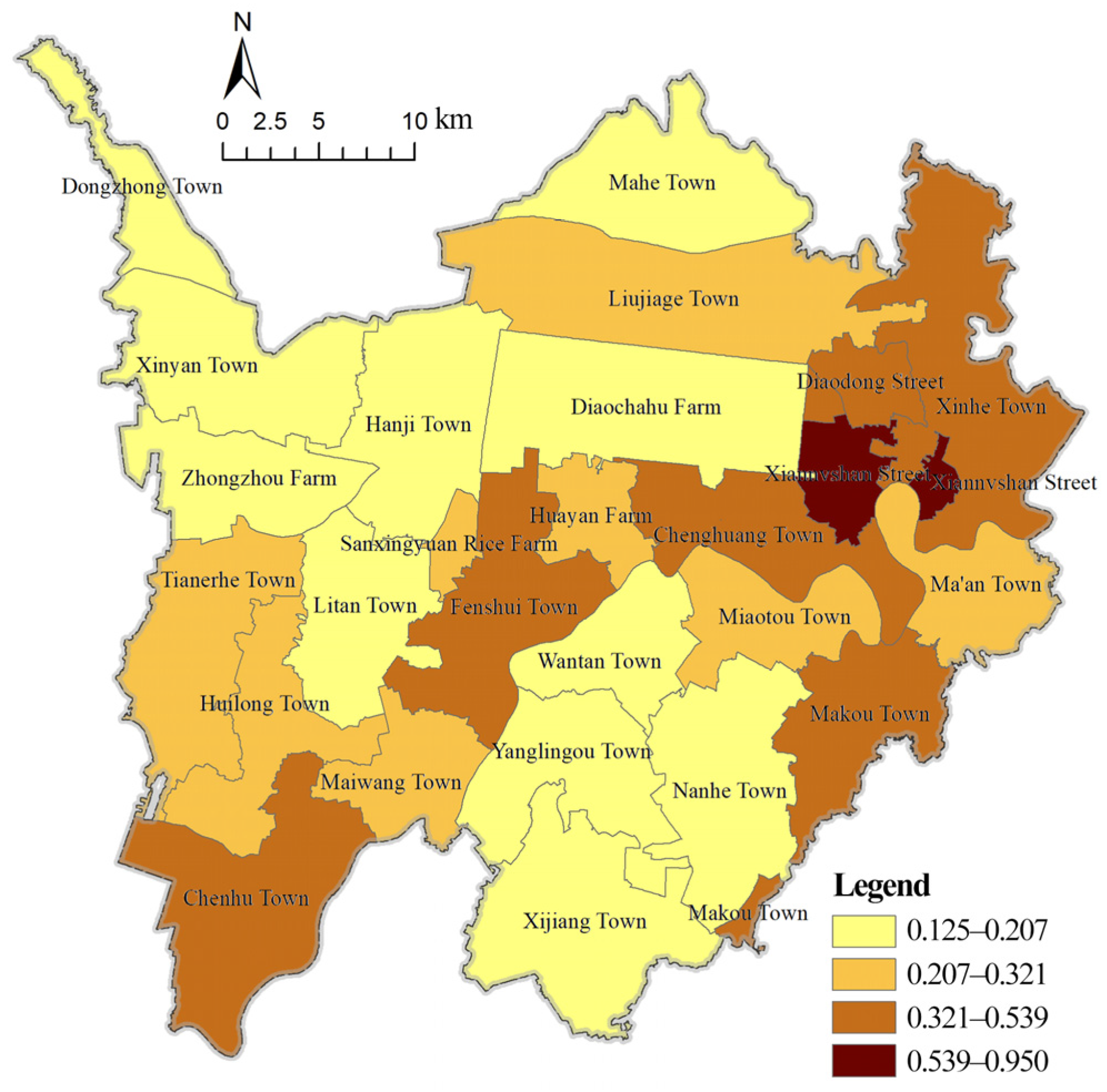
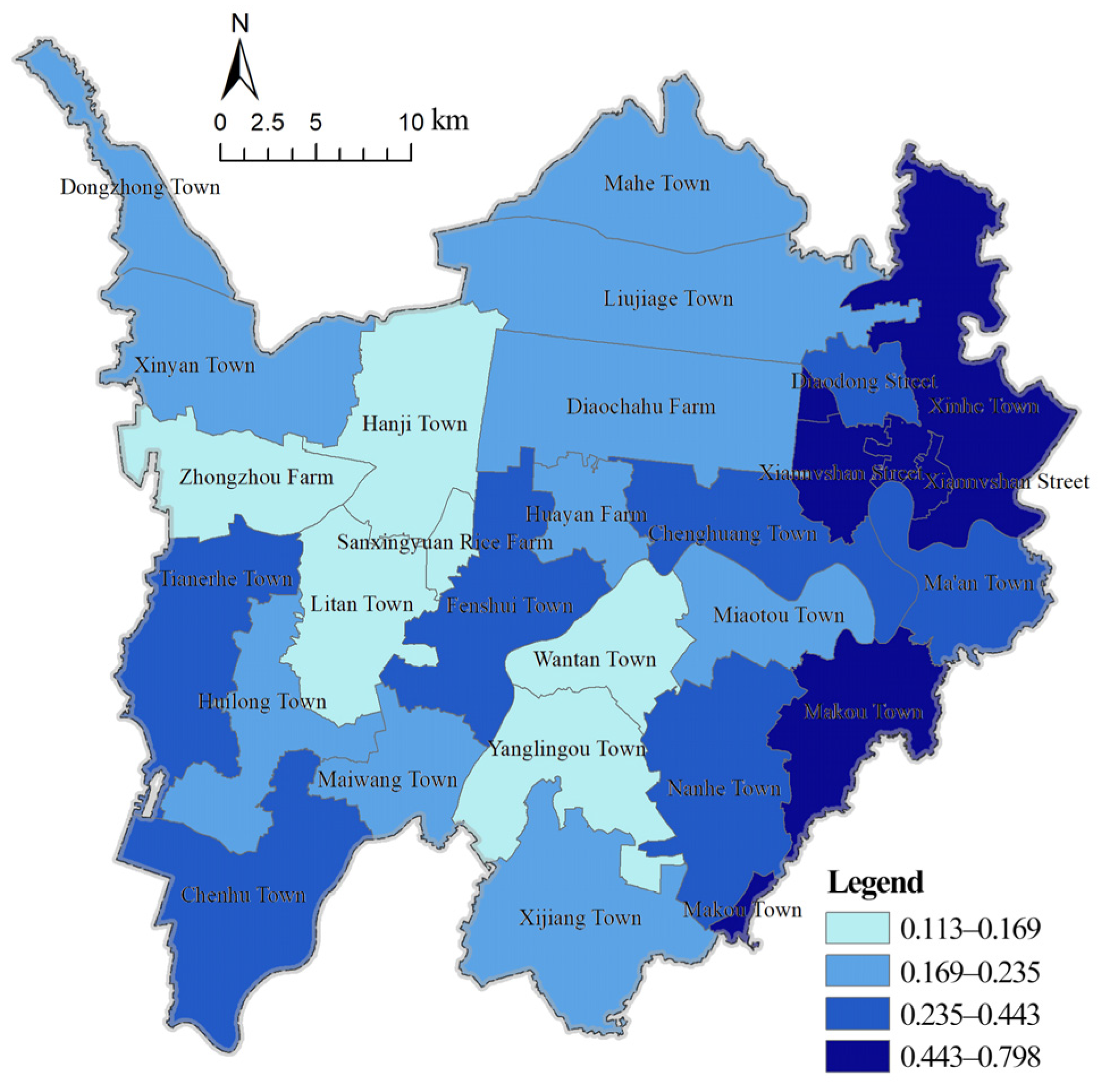
3.1.3. The Comprehensive Evaluation of Urban–Rural Integration Development

The results of current and potential urban–rural integration development levels are weighted and summed to calculate the comprehensive evaluation results. The weights of the current and potential urban–rural integration development levels were determined to be 0.4 and 0.6, respectively, resulting in the revised current and potential scores (Table 3). The natural breakpoint method was used to classify the comprehensive evaluation results into four categories (Figure 5).
The spatial patterns of the comprehensive evaluation results of urban–rural integration development in Hanchuan city gradually decrease from the northeast and southwest to the central area. The eastern part of Hanchuan is adjacent to Wuhan, which is the core city of the Wuhan metropolitan area. The urban area of Hanchuan is also located in the northeastern part of the county, which is influenced by the radiation of Wuhan city and the central urban area of Hanchuan, thus the overall level of the central urban area and its surrounding townships is high and gradually decreases from the central urban area outward. Although some of the towns in southwestern Hanchuan are far away from Wuhan and Hanchuan’s central urban area, such as Chenhu Town, they have the advantage of being close to the central urban area of Xiantao City, thus leading to a strong industrial base and a high level of integrated urban–rural development. In contrast, the towns in the central region are relatively weakly driven by the radiation of the surrounding growth poles (such as the central urban area of Hanchuan and Wuhan City adjacent to the eastern part of Hanchuan, and the central urban area of Xiantao City adjacent to the southwestern part).

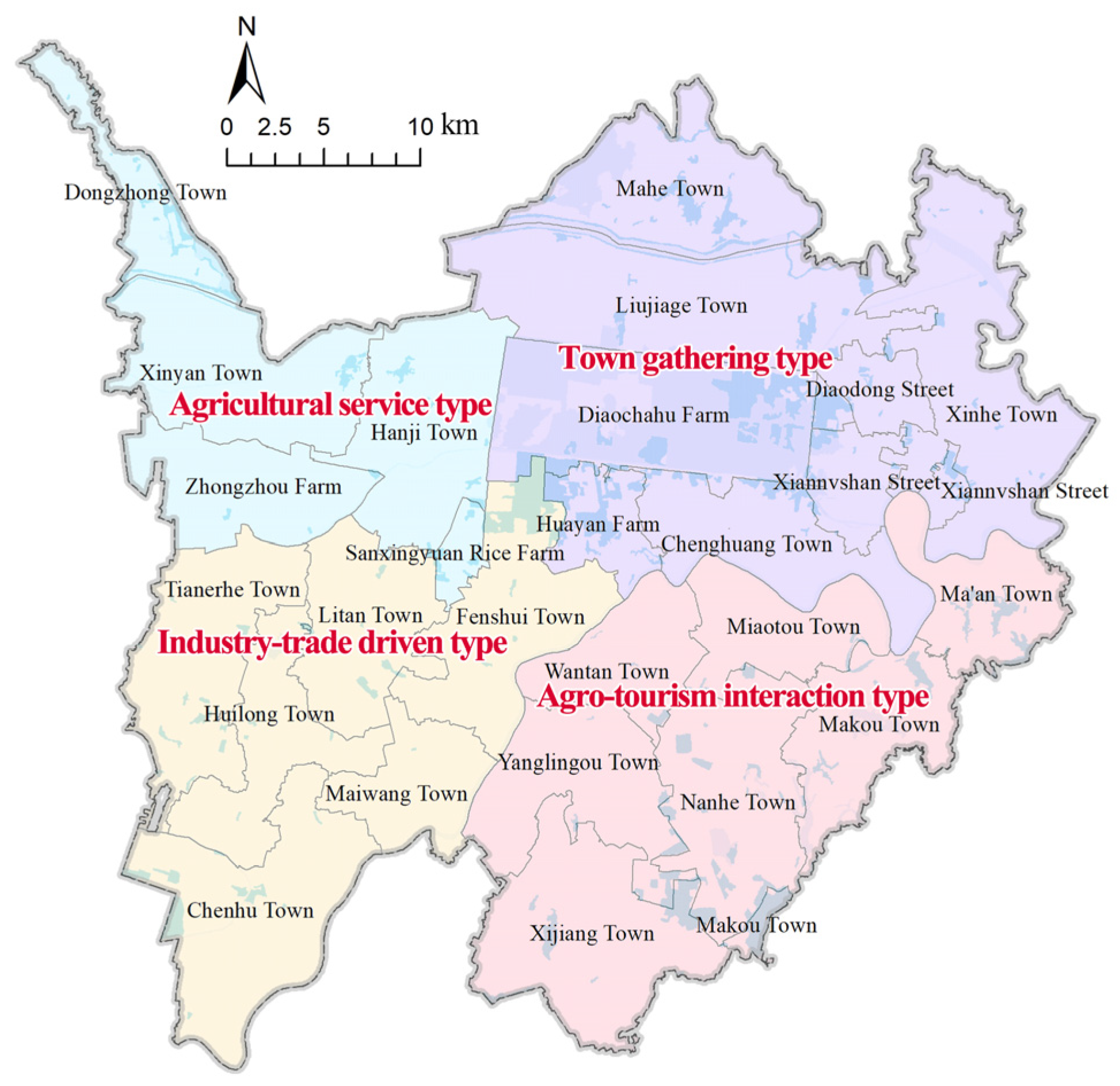
3.2. Divisons of Urban–Rural Integration Development Zones

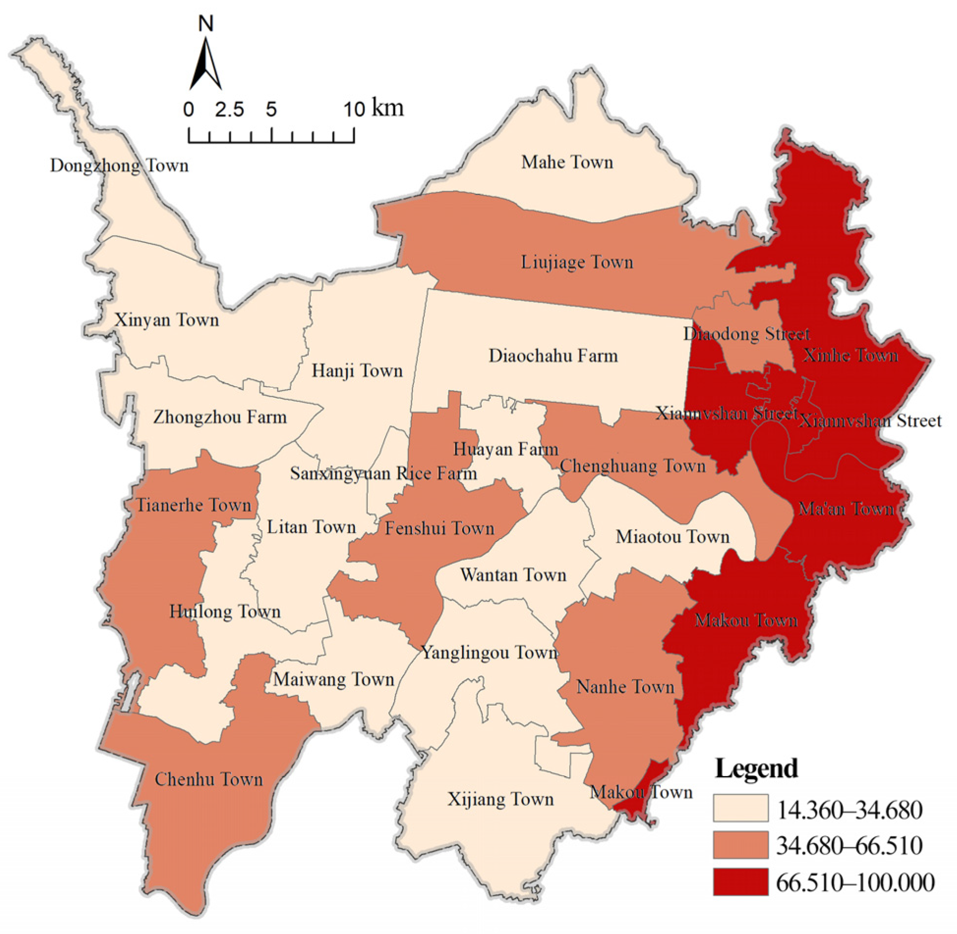
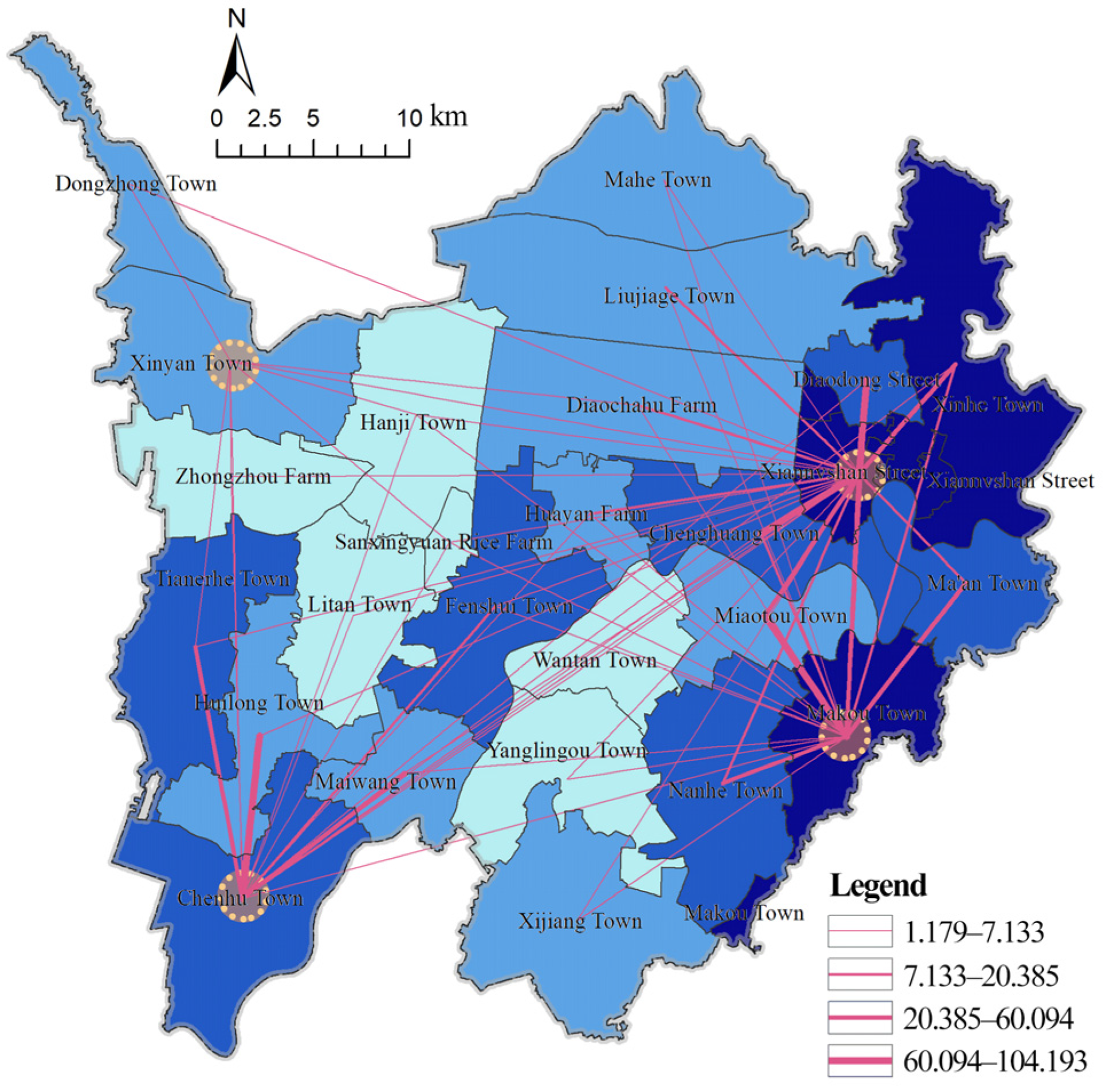
3.2.1. The Centers of Urban–Rural Integration Development Zones

According to the central place theory [41], regional network structure theory [42], and the territorial spatial master planning, the 26 towns in the whole area of Hanchuan city are roughly divided into four regions: northeast, southeast, southwest, and northwest. Towns with the highest combined scores of the current and potential development levels were selected as urban–rural integration development centers in each of the four regions. Therefore, Xiannvshan Street, Makou Town, Chenhu Town and Xinyan Town were selected as the centers of the northeast, southeast, southwest and northwest of Hanchuan City, respectively. These four centers drive the hinterland of surrounding towns to integrate development (Figure 6).

3.2.2. Zones of Urban–Rural Integration Development

The gravity model was used to calculate the gravity value between the centers and surrounding towns. A larger gravity value means that the town is more closely connected to the selected center. In terms of the setting of quality parameters, the comprehensive evaluation score of each town was taken as the quality, which reflects the strength of a town’s urban–rural integration development more comprehensively. In terms of the setting of the distance parameter, the road distance between the center and each town was taken as the distance parameter because Hanchuan is mainly road traffic. The gravity values between the other 22 townships and the four centers were obtained (as shown in Table 4 and Figure 6), and the spatial extent of the four urban–rural integration development zones were divided according to the principles of similarity and consistency of town development and their environment (Figure 7).

3.3. Recongnition of Urban–Rural Integration Development Pattern

According to the evaluation of the potential development, the multifunctional evaluation of each town within different zones is conducted based on five elements: location and transportation, town scale, agricultural production, non-farm economy, characteristic resources, and so on [43,44]. Using the categorical assignment method, the scores of each element were assigned to seven grade intervals, with a maximum value of eight and the minimum value of two. The scores of the towns within the four development zones were calculated by horizontally comparing the maximum value of each town’s score, comprehensively considering the leading industries of each town and the leading functions of each development zone. The urban–rural integration pattern of Hanchuan City was finally classified into four types: town gathering, agro-tourism interaction, industry-trade driven, and agricultural service (Figure 7).

3.3.1. The Pattern of the Town Gathering Type

The town gathering type has more comprehensive industrial advantages. Xiannvshan Street and Xinhe Town focus on secondary and tertiary industries with strong economic strength; Chenghuang Town and Liujiage Town have developing manufacturing and modern service industries while stabilizing agriculture of the traditional agricultural towns, such as Diaodong Street, Mahe Town and Huayan Farm. From the spatial distribution of the pattern, these eight towns are located in the dense area of the eastern part in Hanchuan City, among which Xiannvshan Street, Diaodong Street and Xinhe Town are partly located within the central urban area. Thus, this type was summarized as the town gathering type pattern by combining the industrial base and spatial distribution.

3.3.2. The Pattern of the Agro-Tourism Interaction Type

The leading functions of the towns within the agro-tourism interaction type are characteristic resources and agricultural production. Through sorting the resource endowment, it was found that Nanhe Town, Yanglingou Town, Ma’an Town, and other towns have good agricultural landscapes or planting bases to develop rural tourism. From the spatial distribution, it can be seen that this type of integration development zone is located to the south of the Hanjiang River and close to the Caidian District of Wuhan City, leading to good tourism location advantages, and can link Huanglong Lake of Ma’an Township, Tianyu Lake of Makou Town, Nanhe Ancient Ferry in Nanhe Town and other scenic spots to form the Hanan agricultural tourism leisure resort area.

3.3.3. The Pattern of the Industry-Trade Driven Type

Most of the towns’ leading industries within the industry-trade driven type are secondary industries, and the urban functions are mainly a non-agricultural economy. In particular, Chenhu Town and Fenshui Town are, respectively famous for their metal products and pharmaceutical packaging, with strong industrial foundations. The surrounding Huilong Town, Maiwang Town, and Chenhu Town have both industrial divisions and cooperation, which is good for forming industrial clusters. While Tianerhe Town can be used as a product trading distribution center by its geographical advantages at the junction of the two cities. Though Litan Town is a traditional agricultural town, it can provide raw materials and labor for industrial development. Therefore, this pattern was summarized as the industry-trade driven type.

3.3.4. The Pattern of the Agricultural Service Type

Towns within the agricultural service type are located in the vicinity of the Jianghan Plain, and their leading function is agricultural production. The traditional agricultural town of Xinyan is the unit center. The leading industries are high-quality rice cultivation, special aquaculture and fine processing industry of agricultural products. Among them, Xinyan Town and Hanji Town have the foundation of developing new modern agriculture; Dongzhong Town relies on a planting foundation to develop melon fruit and a flower industry; Zhongzhou Farm has the largest area of hybrid cotton base in Hanchuan. The last round of master planning also positioned the area as a grain production base, a special aquaculture base and an important fruit and vegetable production base of Hanchuan city. Thus, this pattern was summarized as the agricultural service type.

4. Implications for Urban–Rural Integration Development Planning

4.1. Centralization

Building a five-level hierarchy of “central urban area—subcentral town—key town—general town—new rural community” is needed to strengthen the agglomeration effect of the central urban area, sub-central town, and key town, to thus guide the orderly and efficient development of urban and rural areas and drive the construction of industries and facilities in general towns and central villages. Among them, the subcenter towns are supported by expanding the scale of construction, actively accepting the overflow of manufacturing functions from urban areas and neighboring cities in the region, developing employment- and technology-oriented labor-intensive industries, and improving public service facilities. As linkages between the central urban area, subcenter towns, general towns and key towns are important nodes and must act as the backbone of urban–rural integration in Hanchuan City by using favorable conditions such as transportation and natural resources to develop tourism, agricultural and sideline product processing industries to build a service center that radiates to the surrounding rural areas. Combining the analysis of the village distribution planning of each town and the territorial spatial master planning of the development conditions and development potential of villages, priority will be given to select settlements with good development conditions and build new rural communities in combination with resettlement.

4.2. Differentiation

Due to the great difference between the east and west directions of Hanchuan City, different guidance should be taken to promote the integrated development of urban and rural areas. The development paths and management of towns and villages in different zones should be planned in a focused and targeted manner. According to the differences in resource endowments and industrial development of each town, four different urban–rural integration development patterns are proposed, namely, town gathering type, agro-tourism interaction type, industry-trade driven type, and agricultural service type. Town gathering type pattern applies to the central urban areas of Hanchuan. Agro-tourism interaction type pattern applies to the areas with rich tourism resources. Industry-trade driven type pattern applies to the areas around key towns. Agricultural service type pattern applies to the areas with traditional agricultural production and poor industrial foundation and lack of infrastructure. Through the above classification, the development gap between the east and the west of Hanchuan city could be narrowed, leading to balanced development and striving to make up for the backwardness of the development of western villages and towns.

4.3. Demonstration

It is of great importance to build some demonstration areas, such as the central urban area of Hanchuan and Makou Town, to provide development guidance for other towns. The central urban area of Hanchuan has a good economic foundation and comprehensive functions. These areas focus on integrating the complex resource elements in the region to form an urban–rural ecosystem with a two-way flow of elements. Makou Town, relying on its strong industrial foundation and tourism resources, can serve as a dual demonstration area of agro-tourism interaction and industry-trade driven integration development pattern. It could build a modern rural community and give priority to the transformation from agriculture and rural areas to industry-trade towns. To narrow the gap between urban–rural development, these urban–rural integration demonstration zones could promote the two-way free flow of urban–rural production and the rational allocation of public resources. The demonstration zones should break the institutional drawbacks, complement the policy weaknesses to establish the urban–rural integration development system and policy system to provide a replicable typical experience for Hanchuan City.

5. Discussion

5.1. The Mechanism for Forming Urban–Rural Integration Development Patterns

Previous studies on urban–rural integration mainly focused on the evaluation of the development level of urban–rural integration [32], while less attention has been paid to what should be carried out after the evaluation. Therefore, the evaluation results cannot be well integrated with the subsequent planning implementation. In addition, in terms of evaluation contents, previous studies have often focused on measuring the current level of development, while less attention has been paid to the future development potential of urban–rural integration. Unlike previous studies, this study argues that the current and potential levels, patterns, and strategies of urban–rural integration development all differ within a city from the perspective of spatial heterogeneity [45].
At present, the county level urban–rural integration development is still in the stage of continuous exploration. Cultivating urban–rural integration development zone is an efficient way from the perspective of clusters. Based on the evaluation results of the current and potential level of urban–rural integration development, the gravity model was used to divide the study area into different urban–rural integration development zones with different development patterns. The formation of the four urban–rural integration development patterns is mainly the combinations of two forces, the internal and external of the city. For the internal forces, urban–rural integration development patterns are closely related to the spatial distribution of natural and human resources in the county, as well as the overall territorial spatial plan. For the external forces, the Wuhan metropolitan area, cannot be ignored as a driving force for its integrated urban–rural development. Hanchuan is adjacent to Wuhan, which is the core city of the Wuhan metropolitan area. According to the growth pole theory, Wuhan city is the first growth pole of the Wuhan metropolitan area and has a strong attraction effect on the population, economy and other factors in the surrounding areas [46]. Therefore, the integrated urban–rural development and the formation of specific patterns in Hanchuan are also subject to a larger role of the core city.
However, the specific role of the core cities in the metropolitan area in the urban–rural integration of the surrounding cities needs to be further discussed. For instance, when the core cities promote the development of urban and rural areas, and whether they promote the continuous reduction or expansion of the relative gap between urban and rural areas in the surrounding counties. The formation mechanism of their urban–rural integration development patterns may vary from cities outside the metropolitan area. There are likely to be some differences even in their internal urban–rural integration development patterns, except that the specific types of patterns are exactly the same as Hanchuan’s urban–rural integration development patterns.

5.2. Limitations

China is actively promoting the development of new-type urbanization and urban–rural integration. To continually direct the efficient circulation of urban–rural elements and strengthen the urban–rural governance system, it should completely combine the resource advantages and potentials within each county and plan differentiated urban–rural integration development patterns. The results of this study can provide direct support for the preparation and implementation of township-level territorial spatial planning, and the layout planning of rural settlements in the county and the allocation of urban and rural infrastructure and public service facilities. This study builds an index system for evaluating urban–rural integration development level which is made up of socio-economic and land-use-related indexes; however, two main shortcomings exist. First, due to data limitations, this study was not based on a dynamic assessment [47] and did not consider the trends in the evolving level of urban–rural integration development over the study years. Secondly, due to some constraints, such as time and finance, a comprehensive survey on the degree of happiness of residents, or satisfaction with the current status of urban–rural integration development, or other subjective feelings were not considered. In the future, the evaluation model of urban–rural integration development level should be further improved by combining it with survey data and so on.

6. Conclusions

This study constructed a comprehensive evaluation system of urban–rural integration development based on the current and potential level of development, taking Hanchuan City, located in the Wuhan metropolitan area, as the case study area at the county level. After evaluating the comprehensive level of urban–rural integration development, the gravity model was used to scientifically delineate the scope of the urban–rural integration development zones. Four different types of urban–rural integration development patterns were identified: town gathering, agro-tourism interaction, industry-trade driven, and agricultural service. Finally, the corresponding optimization strategies were targeted. The comprehensive evaluation results and recognized patterns of urban–rural integration development were effectively connected with county-level and township-level territorial spatial planning, which could provide direct guidance for the determination of the county–town system and the development direction of each zone within the county. In addition, the methodological evaluation system of urban–rural integration development and pattern recognition established in this study is not only applicable to Hanchuan City within the Wuhan metropolitan area, but may also be of reference value to other counties or cities within or outside the metropolitan area.

Author Contributions

Conceptualization, S.L., Y.H. and Y.D.; methodology, X.W. and Y.D.; software, S.L., X.W. and Y.D.; validation, S.L. and Y.D.; formal analysis, X.W. and Y.D.; investigation, X.W., Y.H. and Y.D.; resources, S.L. and Y.H.; data curation, X.W. and Y.D.; writing—original draft preparation, S.L., X.W. and Y.D.; writing—review and editing, S.L. and Y.H.; visualization, X.W. and Y.D.; supervision, S.L. and Y.H.; project administration, S.L. and Y.H.; funding acquisition, S.L. and Y.H. All authors have read and agreed to the published version of the manuscript.

Funding

This research was funded by the National Natural Science Foundation of China (No. 41901390 and No. 51978299), the Natural Science Foundation of Hubei Province (No. 2021CFB012), the Social Science Foundation of Hubei Province (Post-Funded Project No. 203), and Key Program of the National Social Science Foundation of China (21AZD048).

Data Availability Statement

The data used in this study can be requested from the authors.

Conflicts of Interest

The authors declare no conflict of interest.

References

  1. Caffyn, A.; Dahlström, M. Urban-Rural Interdependencies: Joining up Policy in Practice. Reg. Stud. 2005, 39, 283–296. [Google Scholar] [CrossRef]
  2. Liu, Y. Research on the Urban-Rural Integration and Rural Revitalization in the New Era in China. Acta Geogr. Sin. 2018, 73, 637–650. [Google Scholar] [CrossRef]
  3. Overbeek, G. Opportunities for Rural-Urban Relationships to Enhance the Rural Landscape. J. Environ. Policy Plan. 2009, 11, 61–68. [Google Scholar] [CrossRef]
  4. Liu, Y.; Li, Y. Revitalize the World’s Countryside. Nature 2017, 548, 275–277. [Google Scholar] [CrossRef] [Green Version]
  5. Simon, D. Co-Productive Tools for Transcending the Divide: Building Urban–Rural Partnerships in the Spirit of the New Leipzig Charter. Land 2021, 10, 894. [Google Scholar] [CrossRef]
  6. Yao, Y.; Liang, M. Logic of Political Economics in the Development of Urban and Rural Integration–An Investigation on the Development of New China in the past 70 years. Seeking Truth 2019, 46(05), 11–18. [Google Scholar]
  7. Liu, Y.; Lu, S.; Chen, Y. Spatio-Temporal Change of Urban-Rural Equalized Development Patterns in China and Its Driving Factors. J. Rural Stud. 2013, 32, 320–330. [Google Scholar] [CrossRef]
  8. Li, S.; Chen, J.; Teng, Y. Rural Revitalization on the Path of Common Prosperity: Problems, Challenges and Suggestions. J. Lanzhou Univ. (Soc. Sci.) 2021, 49, 37–46. [Google Scholar]
  9. Lovell, D.W. Socialism, Utopianism and the “Utopian Socialists”. Hist. Eur. Ideas 1992, 14, 185–201. [Google Scholar] [CrossRef]
  10. Bussard, R.L. The “dangerous Class” of Marx and Engels: The Rise of the Idea of the Lumpenproletariat. Hist. Eur. Ideas 1987, 8, 675–692. [Google Scholar] [CrossRef]
  11. Batchelor, P. The Origin of the Garden City Concept of Urban form. J. Soc. Archit. Hist. 1969, 28(3), 184–200. [Google Scholar] [CrossRef]
  12. Pribadi, D.O.; Pauleit, S. The Dynamics of Peri-Urban Agriculture during Rapid Urbanization of Jabodetabek Metropolitan Area. Land Use Policy 2015, 48, 13–24. [Google Scholar] [CrossRef]
  13. Wang, Y.; Liu, Y.; Li, Y.; Li, T. The Spatio-Temporal Patterns of Urban-Rural Development Transformation in China since 1990. Habitat Int. 2016, 53, 178–187. [Google Scholar] [CrossRef]
  14. Sun, Y.; Yang, Q. Study on Spatial–Temporal Evolution Characteristics and Restrictive Factors of Urban–Rural Integration in Northeast China from 2000 to 2019. Land 2022, 11, 1195. [Google Scholar] [CrossRef]
  15. Yin, Z.H.; Choi, C.H. Does E-Commerce Narrow the Urban–Rural Income Gap? Evidence from Chinese Provinces. Internet Res. 2022, 32, 1427–1452. [Google Scholar] [CrossRef]
  16. Requena, F. Rural–Urban Living and Level of Economic Development as Factors in Subjective Well-Being. Soc. Indic. Res. 2016, 128, 693–708. [Google Scholar] [CrossRef]
  17. Tian, Y.; Qian, J.; Wang, L. Village Classification in Metropolitan Suburbs from the Perspective of Urban-Rural Integration and Improvement Strategies: A Case Study of Wuhan, Central China. Land Use Policy 2021, 111, 105748. [Google Scholar] [CrossRef]
  18. Ye, Y.; Legates, R.; Qin, B. Coordinated Urban-Rural Development Planning in China. J. Am. Plan. Assoc. 2013, 79, 125–137. [Google Scholar] [CrossRef]
  19. Chen, C.; LeGates, R.; Fang, C. From Coordinated to Integrated Urban and Rural Development in China’s Megacity Regions. J. Urban Aff. 2019, 41, 150–169. [Google Scholar] [CrossRef]
  20. Davoudi, S.; Stead, D. Urban–Rural Relationships: An Introduction and Brief History. Built Environ. 2006, 122, 25–27. [Google Scholar]
  21. Mayer, H.; Habersetzer, A.; Meili, R. Rural-Urban Linkages and Sustainable Regional Development: The Role of Entrepreneurs in Linking Peripheries and Centers. Sustainability 2016, 8, 745. [Google Scholar] [CrossRef] [Green Version]
  22. Liu, J.; Liu, M.; Deng, X.; Zhuang, D.; Zhang, Z.; Luo, D. The Land Use and Land Cover Change Database and Its Relative Studies in China. J. Geogr. Sci. 2002, 12, 275–282. [Google Scholar]
  23. Chuanglin, F. Theoretical Foundation and Patterns of Coordinated Development of the Beijing-Tianjin-Hebei Urban Agglomeration. Prog. Geogr. 2017, 36, 15–24. [Google Scholar] [CrossRef] [Green Version]
  24. Ma, L.; Liu, S.; Fang, F.; Che, X.; Chen, M. Evaluation of Urban-Rural Difference and Integration Based on Quality of Life. Sustain. Cities Soc. 2020, 54, 101877. [Google Scholar] [CrossRef]
  25. Song, M.; Tao, W. Coupling and Coordination Analysis of China’s Regional Urban-Rural Integration and Land-Use Efficiency. Growth Change 2022, 53, 1384–1413. [Google Scholar] [CrossRef]
  26. Rao, C.; Gao, Y. Evaluation Mechanism Design for the Development Level of Urban-Rural Integration Based on an Improved TOPSIS Method. Mathematics 2022, 10, 380. [Google Scholar] [CrossRef]
  27. Yan, J.; Chen, H.; Xia, F. Toward Improved Land Elements for Urban–Rural Integration: A Cell Concept of an Urban–Rural Mixed Community. Habitat Int. 2018, 77, 110–120. [Google Scholar] [CrossRef]
  28. Qian, L.; Zhang, K.; Song, J.X.; Tang, W.Y. Regional Differences and Convergence of Urban-Rural Integration Development from the Perspective of Factor Flow. J. Environ. Public Health 2022, 2022, 2695366. [Google Scholar] [CrossRef]
  29. Zhao, W.; Jiang, C. Analysis of the Spatial and Temporal Characteristics and Dynamic Effects of Urban-Rural Integration Development in the Yangtze River Delta Region. Land 2022, 11, 1054. [Google Scholar] [CrossRef]
  30. Sun, Y.; Zhao, T.; Xia, L. Spatial-Temporal Differentiation of Carbon Efficiency and Coupling Coordination Degree of Chinese County Territory and Obstacles Analysis. Sustain. Cities Soc. 2022, 76, 103429. [Google Scholar] [CrossRef]
  31. Malah, A.; Bahi, H. Integrated Multivariate Data Analysis for Urban Sustainability Assessment, a Case Study of Casablanca City. Sustain. Cities Soc. 2022, 86, 104100. [Google Scholar] [CrossRef]
  32. Yang, Y.; Bao, W.; Wang, Y.; Liu, Y. Measurement of Urban-Rural Integration Level and Its Spatial Differentiation in China in the New Century. Habitat Int. 2021, 117, 102420. [Google Scholar] [CrossRef]
  33. Bu, X.; Pu, L.; Shen, C.; Xie, X.; Xu, C. Study on the Spatial Restructuring of the Village System at the County Level Oriented toward the Rural Revitalization Strategy: A Case of Jintan District, Jiangsu Province. Land 2020, 9, 478. [Google Scholar] [CrossRef]
  34. Zhang, B.; Zhang, J.; Miao, C. Urbanization Level in Chinese Counties: Imbalance Pattern and Driving Force. Remote Sens. 2022, 14, 2268. [Google Scholar] [CrossRef]
  35. Long, H.; Zou, J.; Pykett, J.; Li, Y. Analysis of Rural Transformation Development in China since the Turn of the New Millennium. Appl. Geogr. 2011, 31, 1094–1105. [Google Scholar] [CrossRef]
  36. Wang, Y.; Cao, X. Village Evaluation and Classification Guidance of a County in Southeast Gansu Based on the Rural Revitalization Strategy. Land 2022, 11, 857. [Google Scholar] [CrossRef]
  37. Liu, S.; Ge, J.; Bai, M.; Yao, M.; He, L.; Chen, M. Toward Classification-Based Sustainable Revitalization: Assessing the Vitality of Traditional Villages. Land Use Policy 2022, 116, 106060. [Google Scholar] [CrossRef]
  38. Jeong, J.S.; García-Moruno, L.; Hernández-Blanco, J.; Jaraíz-Cabanillas, F.J. An Operational Method to Supporting Siting Decisions for Sustainable Rural Second Home Planning in Ecotourism Sites. Land Use Policy 2014, 41, 550–560. [Google Scholar] [CrossRef]
  39. Maliene, V.; Fowles, S.; Atkinson, I.; Malys, N. A Sustainability Assessment Framework for the High Street. Cities 2022, 124, 103571. [Google Scholar] [CrossRef]
  40. Wu, J.; Yi, T.; Wang, H.; Wang, H.; Fu, J.; Zhao, Y. Evaluation of Medical Carrying Capacity for Megacities from a Traffic Analysis Zone View: A Case Study in Shenzhen, China. Land 2022, 11, 888. [Google Scholar] [CrossRef]
  41. Taylor, P.J.; Hoyler, M. Lost in Plain Sight: Revealing Central Flow Process in Christaller’s Original Central Place Systems. Reg. Stud. 2021, 55, 345–353. [Google Scholar] [CrossRef]
  42. Forsberg, G.; Lindgren, G. Regional Policy, Social Networks and Informal Structures. Eur. Urban Reg. Stud. 2015, 22, 368–382. [Google Scholar] [CrossRef]
  43. Reimer, B. A Sample Frame for Rural Canada: Design and Evaluation. Reg. Stud. 2002, 36, 845–859. [Google Scholar] [CrossRef]
  44. Li, Y.; Long, H.; Liu, Y. Spatio-Temporal Pattern of China’s Rural Development: A Rurality Index Perspective. J. Rural Stud. 2015, 38, 12–26. [Google Scholar] [CrossRef]
  45. Mowl, G.; Barke, M.; King, H. Exploring the Heterogeneity of Second Homes and the ‘Residual’ Category. J. Rural Stud. 2020, 79, 74–87. [Google Scholar] [CrossRef]
  46. Zheng, Y.; Tan, J.; Huang, Y.; Wang, Z. The Governance Path of Urban–Rural Integration in Changing Urban–Rural Relationships in the Metropolitan Area: A Case Study of Wuhan, China. Land 2022, 11, 1334. [Google Scholar] [CrossRef]
  47. Sánchez-Zamora, P.; Gallardo-Cobos, R.; Ceña-Delgado, F. Rural Areas Face the Economic Crisis: Analyzing the Determinants of Successful Territorial Dynamics. J. Rural Stud. 2014, 35, 11–25. [Google Scholar] [CrossRef]
Figure 1. Study area. (a) Locations of the study area in China. (b) Locations of the study area in the Wuhan metropolitan area. (c) Land use of the study area.
Land 12 00014 g001
Figure 2. Research framework of this research.
Land 12 00014 g002
Figure 3. Spatial distribution of current urban–rural integration development level of each town in Hanchuan City.
Land 12 00014 g003
Figure 4. Spatial distribution of potential urban–rural integration development in each town of Hanchuan City.
Land 12 00014 g004
Figure 5. Spatial distribution of the comprehensive evaluation results of urban–rural integration development.
Land 12 00014 g005
Figure 6. Spatial distribution of urban–rural integration development centers.
Land 12 00014 g006
Figure 7. Spatial distribution of the urban–rural integration development pattern.
Land 12 00014 g007
Table 1. Evaluation system of the current urban–rural integration development level.
TargetCriterionsIndicatorsUnitMethod of CalculationIndex Attribute
Evaluation of the current Urban–rural Integration Development (A)Urban–rural population integration (A1) [25]Level of population urbanization (A01)%(Number of urban population/Total population) × 100%Positive
Rate of urban and rural population going out (A02)%(Number of outworkers/Total population) × 100%Negative
Proportion of agricultural labor (A03)%Number of labor force in (primary industry/Total labor force) × 100%Negative
Urban–rural spatial integration (A2) [26]Urban–rural road network density (A04)km/km2(Road length/Total land area) × 100%Positive
Urban–rural public service facilities density ratio (A05)%(Density of rural public service facilities/Density of urban public service facilities) × 100%Positive
Level of land urbanization (A06)%(Area of built-up area/Total land area) × 100%Positive
Urban–rural economic integration (A3) [27]Ratio of non-agricultural output value to agricultural output value (A07)%(Non-agricultural output value/Agricultural output value) × 100%Positive
Per capita GDP (A08)YuanGDP/Total populationPositive
Rural per capita net income (A09)Yuan-Positive
Output value of industrial enterprises above designated size (A10)Billion yuan-Positive
Urban–rural social integration (A4) [28]Every ten thousand people have the number of primary school teachers (A11)PeopleNumber of elementary school teachers/10,000 peoplePositive
Number of students in urban–rural primary schools (A12)People-Positive
Number of health technicians per thousand population in urban–rural areas (A13)PeopleNumber of health technicians/Thousands of peoplePositive
Number of medical beds per thousand population (A14)Beds/1000 peopleNumber of beds in urban–rural medical institutions/Thousands of peoplePositive
Urban–rural ecological integration (A5) [29]Urban–rural garbage harmless disposal rate (A15)%(Amount of harmless garbage disposal/Amount of urban–rural garbage generation) × 100%Positive
Table 2. Evaluation system of the potential level of urban–rural integration development.
TargetCriterionsIndicatorsScoring Standard
Urban–rural integration development potential (B)Location and Transportation (B1) [33]Is the town located around economically developed areas (B01)5 points for proximity to large cities, 3 points for the periphery of the central city, 2 points for being located in the development axis, and 1 point for other areas
Distance of the town from transportation hubs and roads (B02)High-speed railway station, high-speed exit, rail transit station, national highway, provincial highway, other roads are assigned 5, 4, 4, 3, 2, 1
Town scale (B2) [34]Whether the township is a key development township (B03)National key town assignment points 5, provincial model towns, central town assignment points 3, general town assignment points 1
Population size (B04)Total resident population size
Township construction scale (B05)Township built-up area land size
Economic level (B3) [35]Industrial output (B06)The output value of industrial enterprises above the scale
Number of Industrial Parks (B07)Current and planned number of industrial parks
Per capita net income of farmers (B08)-
Agricultural production (B09)Average grain land yield
Facility Construction (B4) [36]Educational Facilities (B10)Number of primary and secondary schools
Medical Facilities (B11)Number of medical beds per 1000 population
Garbage disposal (B12)Township waste disposal rate
Characteristic resources (B5) [37]Natural Waters (B13)Lakes, rivers, wetlands, assigned 5, 3, 2, respectively
Geographical system (B14)Forest land, water area, arable land, and town are assigned 5, 3, 2, and 1 point, respectively.
Brand Resources (B15)National well-known trademarks and provincial famous trademarks are assigned 5 and 3 points, respectively
Tourism Resources (B16)National and provincial scenic spots are assigned 5 and 3 points, respectively
Tangible Cultural Heritage (B17)According to the heritage level, the national level is assigned 5 points, the provincial level is assigned 3 points, the municipal level is assigned 1 point
Intangible Cultural Heritage (B18)According to the level of intangible cultural heritage, the national level is assigned 5 points, the provincial level is assigned 3 points, and the municipal level is assigned 1 point.
Table 3. Ranking of the comprehensive evaluation results of urban–rural integration development.
TownUrban–Rural Integration Level Evaluation Revision ScoreUrban–Rural Integration Potential Evaluation Revision ScoreOverall ScoreRanking
Xiannvshan Street0.3800.4180.7981
Makou Town0.2130.4100.6242
Xinhe Town0.2160.3540.5703
Chenhu Town0.1650.2780.4434
Ma’an Town0.1040.3040.4085
Chenghuang Town0.1530.2200.3736
Fenshui Town0.1540.1990.3537
Diaodong Street0.1620.1740.3368
Nanhe Town0.0810.2430.3249
Tianerhe Town0.0970.2160.31310
Miaotou Town0.1280.1070.23511
Maiwang Town0.1180.1070.22512
Xinyan Town0.0730.1450.21813
Mahe Town0.0750.1410.21614
Dongzhong Town0.0830.1280.21015
Liujiage Town0.0930.1160.21016
Huilong Town0.1040.1010.20517
Diaochahu Farm0.0620.1380.20018
Huayan Farm0.1090.0810.19019
Xijiang Town0.0680.1220.19020
Yanglingou Town0.0800.0890.16921
Sanxingyuan Rice Farm0.1020.0610.16322
Wantan Town0.0810.0690.15023
Hanji Town0.0540.0900.14424
Zhongzhou Farm0.0600.0790.13925
Litan Town0.0530.0600.11326
Table 4. Gravity values between 22 towns and four centers.
TownXiannvshan StreetMakou TownChenhu TownXinyan Town
Xinhe Town60.098.791.821.07
Ma’an Town18.7749.31.080.6
Chenghuang Town104.1919.22.50.83
Fenshui Town7.134.67.841.04
Diaodong Street93.738.741.430.87
Nanhe Town9.6637.490.860.37
Tianerhe Town1.851.0923.131.91
Miaotou Town38.9666.211.050.44
Maiwang Town2.791.4625.740.5
Mahe Town3.661.330.40.25
Dongzhong Town1.180.630.793.78
Liujiage Town14.633.040.660.39
Huilong Town1.590.993.730.82
Diaochahu Farm20.384.491.051.34
Huayan Farm12.354.232.341.01
Xijiang Town2.472.650.910.15
Yanglingou Town3.263.270.750.16
Sanxingyuan Rice Farm2.841.333.23.62
Wantan Town5.055.091.810.18
Hanji Town3.231.261.624.54
Zhongzhou Farm1.370.661.75.6
Litan Town1.190.74.671.04
Disclaimer/Publisher’s Note: The statements, opinions and data contained in all publications are solely those of the individual author(s) and contributor(s) and not of MDPI and/or the editor(s). MDPI and/or the editor(s) disclaim responsibility for any injury to people or property resulting from any ideas, methods, instructions or products referred to in the content.

