Article

Land Use and Land Cover Change Dynamics and Perceived Drivers in Rangeland Areas in Central Uganda

by
Derick Ansyijar Kuule
1,*,
Benard Ssentongo
1,
Paul John Magaya
2,
Gordon Yofesi Mwesigwa
1,
Isaac Tom Okurut
1,
Kenneth Nyombi
1,
Anthony Egeru
1,3 and
John Robert Stephen Tabuti
1
1
Department of Environmental Management, Makerere University, Kampala P.O. Box 7062, Uganda
2
Department of Biological Science, Faculty of Science, Kyambogo University, Kampala P.O. Box 1, Uganda
3
Regional Universities Forum for Capacity Building in Agriculture (RUFORUM), Makerere University Main Campus, 151/155 Garden Hill Rd., Kampala P.O. Box 16811, Uganda
*
Author to whom correspondence should be addressed.
Land 2022, 11(9), 1402; https://doi.org/10.3390/land11091402
Submission received: 26 June 2022 / Revised: 9 August 2022 / Accepted: 16 August 2022 / Published: 26 August 2022

Abstract

:
Sustainable rangeland management requires understanding the nature of human-ecosystem interactions and local communities’ perspectives regarding evolving changes. This study integrated perceptions from the local community and remote sensing to characterize the extent and drivers of land use and land cover (LULC) changes in the rangelands of Nakasongola district in Central Uganda. The aim of the study was to determine the perceived drivers of land use and land cover change in of Nakasongola district in the Central Uganda district to support decision making for present and future rangeland management. Satellite imagery for 1985, 1995, 2005, 2015 and 2021 were obtained from the United States Geological Survey (USGS) and analyzed to determine the LULC dynamics. Key informant interviews and focus group discussions (FGDs) were conducted to obtain perceived drivers of LULC. Results showed that by 1985 grassland covered 31.7%, wetlands 26.4%, woodland 11.5% and farmland 7.2% of the total land area. However, by 2021, farmland covered 35.8% of the total land area, wetland 21.6% and had reduced to grassland 18.5 percent. Future LULC projections using a Markov chain model showed that farmland cover will increase by 13.85% while grassland cover will further decline by 9.89% in 2040. Wood fuel extraction, subsistence farming, population growth and overgrazing were perceived as key drivers of LULC change. Both remote sensing techniques and local perceptions were in agreement with the identification of patterns and perceived drivers revealing the inherent value of tacit knowledge resident within the community. This knowledge in addition to remotely sensed information can thus be tapped by the decision leaders to better guide interventions aimed at securing better rangeland health and management.

1. Introduction

Rangelands cover approximately 41% of the Earth’s total land area [1,2]. Two-thirds of these rangelands are located in arid and semiarid areas [3,4]. Due to the fact that rangelands are mostly located in areas with sporadic rainfall patterns [5], extensive livestock production emerges as the most practiced land use practice [6]
Rangelands are endowed with natural resources such as saltlicks, fodder and water sources varying in space and time that pastoralists harness through seasonal mobility [7] Rangelands provide habitat and breeding grounds for wild ungulates, support carbon storage and provide forage and waters [8]. Rangelands support more than one billion herds of cattle, sheep, camels and goats and nearly two billion people [3].
However, rangelands are under intense pressure from natural and unsustainable anthropogenic factors [2,9]. Accordingly, about 20% of the rangelands have been severely degraded by land uses that degrade rangeland natural resources [2]. An estimated 6 million km2 of land under woodlands/forests and 4.7 million km2 of grasslands worldwide have been converted to croplands since 1850 [10]. The intensive pressure on rangelands is reportedly driving significant changes in the historical land use and land cover (LULC) patterns [9].
It is estimated that rangelands cover about 12.8 million km2 of habitable drylands distributed between arid, semiarid, and dry sub-humid zones in Sub-Saharan Africa [11]. The mode and extent of land use and cover change vary in both space and time in SSA rangelands. Several factors, including climate changes, drought, population growth and policies encouraging sedentary pastoral livelihoods are suspected to be major drivers of rangelands degradation [12]. The proliferation of agricultural land in originally naturally vegetated land is reported among the most outstanding LULC transformations in SSA [13,14]. According to Srivastava [15], vegetation loss due to increased agricultural activities might lead to significant hydrological fluxes due to changes in some hydrological components like surface runoff, surface roughness, stream flow and evapotranspiration. Consequently, the hydrological fluxes can drive changes in land use and land cover in an area [16]. The rapid encroachment of grass species by woody species in the rangelands is also reducing the availability of forage resources for pastoralists [17]. This often forces pastoralists to herd small ruminants like sheep and goats that feed on woody species or even diversifying to non-livestock-based practices [18].
In Uganda, rangelands form one of the land use and land cover types considered prone to natural calamities like floods, droughts, soil erosion and landslides [19,20]. However, rangelands in different parts of the country have undergone tremendous change in the last 40 years [21]. For instance, a decline of 13.1% in grassland cover was earlier reported in Nakasongola district [22]. Frequent severe droughts with return periods of up to 4 years have been reported in Nakasongola [23]; owing to factors such as deforestation, overgrazing and bush fires [24]. The unprecedented rate of LULC changes and their complex drivers of the changes observed present novel challenges to communities within the rangelands [25]. Communities in the rangelands of Uganda are increasingly becoming exposed to deteriorating quality and quantity of goods and services from the rangelands [26]. There is need to invest in rangeland monitoring in order to understand dynamics of vegetation changes and encourage the wise use of natural resources [27]. The estimation of LULC changes is also paramount in establishing the impact of anthropogenic activities on the ecological components of the rangelands such as water resources, plant structure and diversity [16,28]. Such information is essential for the formulation of informed policies to support sustainable rangeland management and rehabilitation for proper natural resource protection and increasing resilience to climate change.
Remote sensing offers one of the best ways of monitoring spatial-temporal environmental changes [10]. Using remote sensing to map the spatial-temporal LULC changes helps in quantitatively establishing the nature of changes. However, the exclusive reliance on remote sensing in LULC assessments has been critiqued for providing only quantitative information and not establishing the relationship between the patterns of change with their driving forces [12]. Moreover, the patterns of LULC changes often involve complex interactions between the environment and humans [21,29]. Based on this, it is becoming increasingly acceptable among scholars of environmental change that it is important to understand the local perceptions on landscapes in order to have a better conceptualization of LULC [30,31]. Local knowledge is widely acknowledged as a credible tool for building knowledge on global environmental changes such as LULC [32,33,34]. It is also acknowledged that integrating local knowledge and remote sensing during LULC changes assessments can provide better and novel understandings for the extent and underlying drivers of change. Understanding the perceptions of the local community on LULC changes is also reported to be central for designing effective land use and management plans [25]. However, there is still a limited integration of local knowledge and remote sensing knowledge in existing studies that investigated the extent and drivers of LULC change across the different parts of Uganda such as Karamoja, Nakasongola and Ankole [22,35,36,37]. The objective of this study was to determine the drivers of land use and land cover change through integration of remote sensing and community perceptions in the Central Uganda district of Nakasongola.

2. Materials and Methods

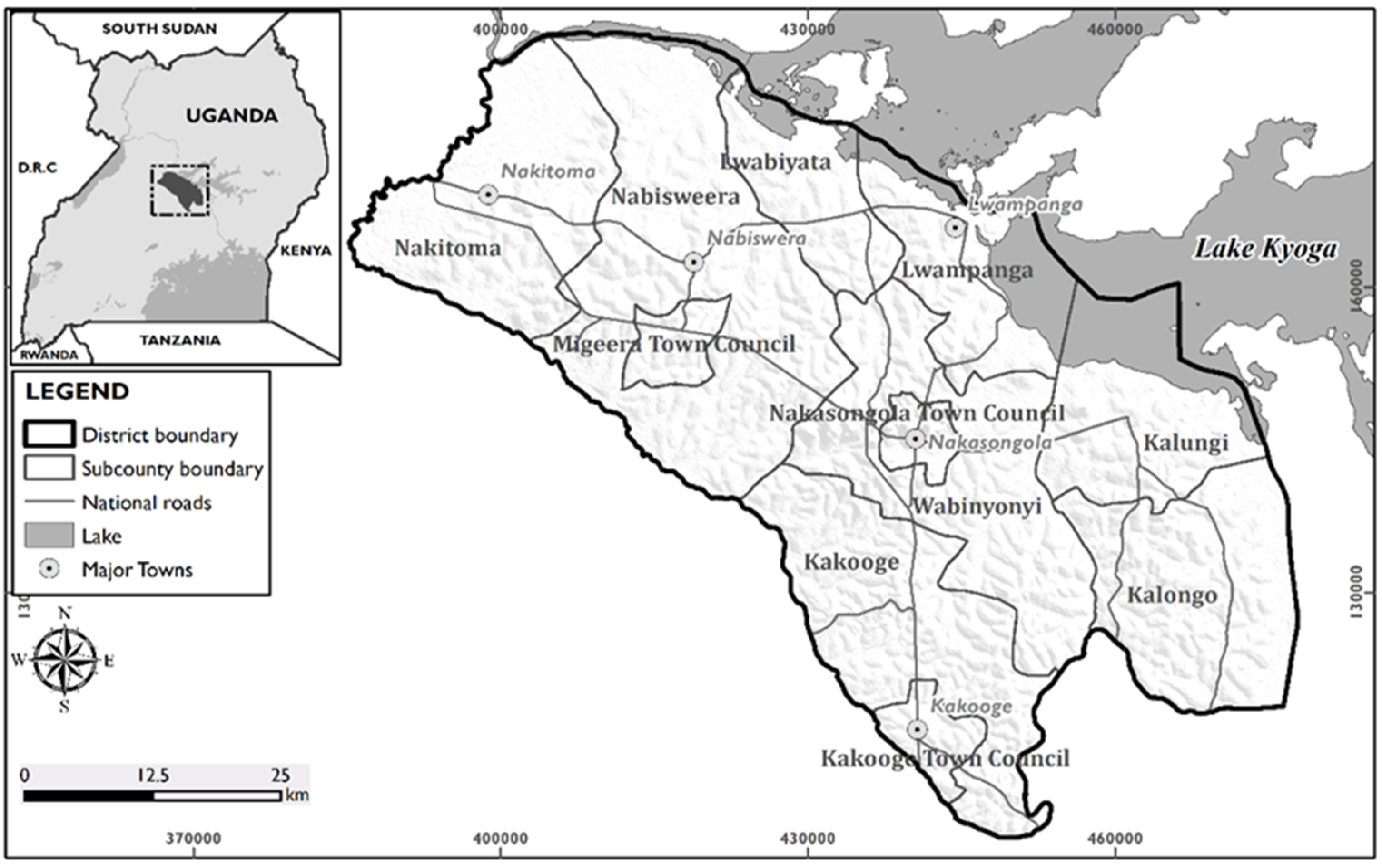
2.1. Study Area Description

This study was conducted in Nakasongola district of Uganda at latitude 0°57′44.89” to 1°40′42.76” North and longitude 31°58′03.77” and 32°48′00.29” East (Figure 1). It covers a total land area of 4909 km2 [20]. Nakasongola district is located in the Cattle Corridor of Uganda. The Cattle Corridor is an extensive area dominated by arid and semi-arid areas (ASALs) [38]. The ecosystems in the rangelands consist of shrubs, woodland and grasslands and are heterogeneous in nature [39].
Rainfall in Nakasongola district ranges between 300800 mm [38]. Nakasongola district is located within Lake Kyoga basin, which is predominated with a bimodal type of rainfall [40]. The first rain season occurs from March/April to June/July and second season occurring from August to October/November has been reported in the area [23]. The mean maximum diurnal temperature ranges between 25 and 35 °C, while the mean diurnal minimum temperatures range between 18 and 25 °C. Severe droughts with return periods of up to 4 years have been reported in the district [23].
The main vegetation types in Nakasongola district include open deciduous savannah woodlands with short grasses, tropical trees and plantations. Crop production and livestock rearing are the main source of livelihood in the district. The major types of crops grown include cassava, sweet potatoes and bananas, while the livestock reared include cattle, goats, sheep and poultry [36]. Other sources of livelihood in the district include fishing, charcoal burning and sand mining.

2.2. Data, Data Sources and Processing

The study involved use of remote sensing and community perceptions obtained using focus-group discussions (FGDs). Satellite images for 1985, 1995, 2005, 2015 and 2021 for Nakasongola district were downloaded from the United States Geological Survey (USGS) Earth explorer website (https://earthexplorer.usgs.gov/) on 15 January 2022. The administrative boundary of Nakasongola district was extracted from the district administrative layer of the Uganda Bureau of Statistics (UBOS). For each year, two satellite scenes were obtained owing to the fact that the study area was covered by two scenes (Appendix A, Table A1). Prior to image classification, radiometric correction, composite generation and contrast stretch were performed on the raw satellite images in ArcGIS 10.8 to provide image enhancement. The scanline errors in Landsat 7 satellite images were removed using the “Fill no data” toolbox in QGIS 3.12. The processed images were then classified using an unsupervised classification technique and an ISODATA algorithm. This classification technique generated several spectral classes that were later assigned respective land use and land cover types. The spectral classes were reclassified into nine informational classes and these included built-up, farmlands, forest, grasslands, open water, shrubs and thickets, tree plantations, wetlands, and woodlands. The description of these classes is provided in Table 1.
Additional datasets were used to assess the accuracy of the classification process. These datasets included the National Land Use and Land Cover Map of 2015, ground truth points and Google Earth images. A total of 424 ground truth points were picked from the field using a Garmin Global Positioning System (GPS) device. An error matrix was computed to assess the degree of correlation between the classified land use and land cover dataset and the ground land use and land cover types (Appendix B, Table A2). Overall accuracy of classification was assessed by dividing the correctly classified sample units by the total number of sample units. According to Dika [43], the formula of accuracy assessment is given by;
Overall Accuracy, A = j = 1 a P j j ; where Pjj represents the proportion of area that has map class i and reference class j. Thus, i represents the proportion of the different land use and land cover type including farmland, wetland, waterbody, woodland, forest and built-up area across the study area during the classification. The reference class j is the area covered by any of the different land use and land cover types using the ground truth data.
The change detection between the different years was assessed by subtracting the current year from the previous year. This generated the losses and gains in the different land use and land cover types between the study periods in Nakasongola district. The Cellular Automata (CA)–Markov model was used to project the future land use and land cover for the district. The model was run using TerrSet Monitoring and Modelling software. The projection was based on a “business-as-usual” scenario (that is if the population continues to increase in Nakasongola district with the subsequent changes in land use and land cover). Using the classified land use and land images of 1985 and 2021 as the past and present study images respectively, the projection process involved change analysis to determine the most prevalent transitions in the study area; developing a transition sub-model; developing a transition probability matrix and a transition potential image; calibration of the CA–Markov model and then projection to 2040 [44] A multi-layer perceptron (MLP) neural network was used in developing a transition potential image. The factors that influence the future land use and land cover for Nakasongola (such as projected population of 2040, the distances from the main road, distance from towns and distance from critical facilities such as health facilities, water sources and schools) were also considered in the model process.

2.3. Community Perceptions

Both key informant interviews and focus group discussions (FGDs) were conducted in order to build a deeper understanding of the land use/land cover change, their key drivers and impacts in the study area. These also aimed at obtaining the local knowledge from local community for integration into this study. The local knowledge investigated included the perceived extent of change in the different land use and land cover in the district of their respective drivers. Key informants involved elders from the community keeping households, local government officials and non-governmental development practitioners.
The number of participants in each FGD ranged between eight and thirteen and were manned by the researcher, local field assistants and local leaders. The age of the respondents ranged between 30–72 years. During the FGDs, the main LULC classes in the study area were identified and mapped where possible. Photographs bearing the different LULC types that had earlier been captured during the reconnaissance study were presented to the respondents in order to identify and map the different LULC types in the study area. Local terms and ecosystem characteristics were used to characterize and classify the different LULC types. Additionally, the perceived LULC changes, the socio-economic importance of each LULC type, the socio-economic drivers of change of each LULC and the impacts arising from the LULC changes were discussed. Both historical and ecological timelines were used to elucidate on specific social and natural events that might have driven certain LULC changes in the study area. The global person generated index [45] was used with the participants of each FGD to select and assign points to the most significant socio-economic drivers and impacts of LULC changes in their respective order of significance. Caution was taken to ensure that consensus is reached amongst the FGD participants during the selection and ranking of the different socio-economic drivers and impacts of LULC changes in the study area.

3. Results

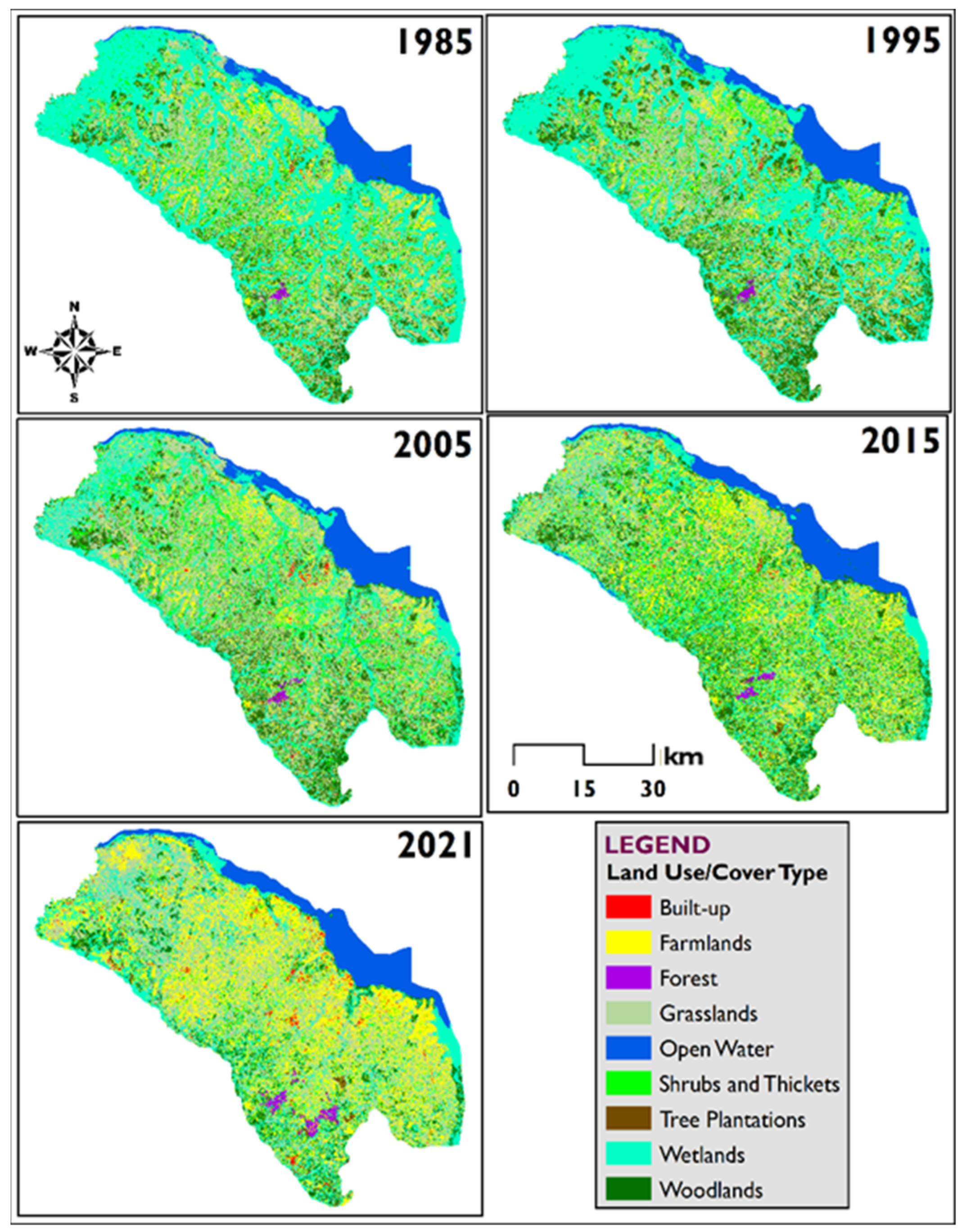
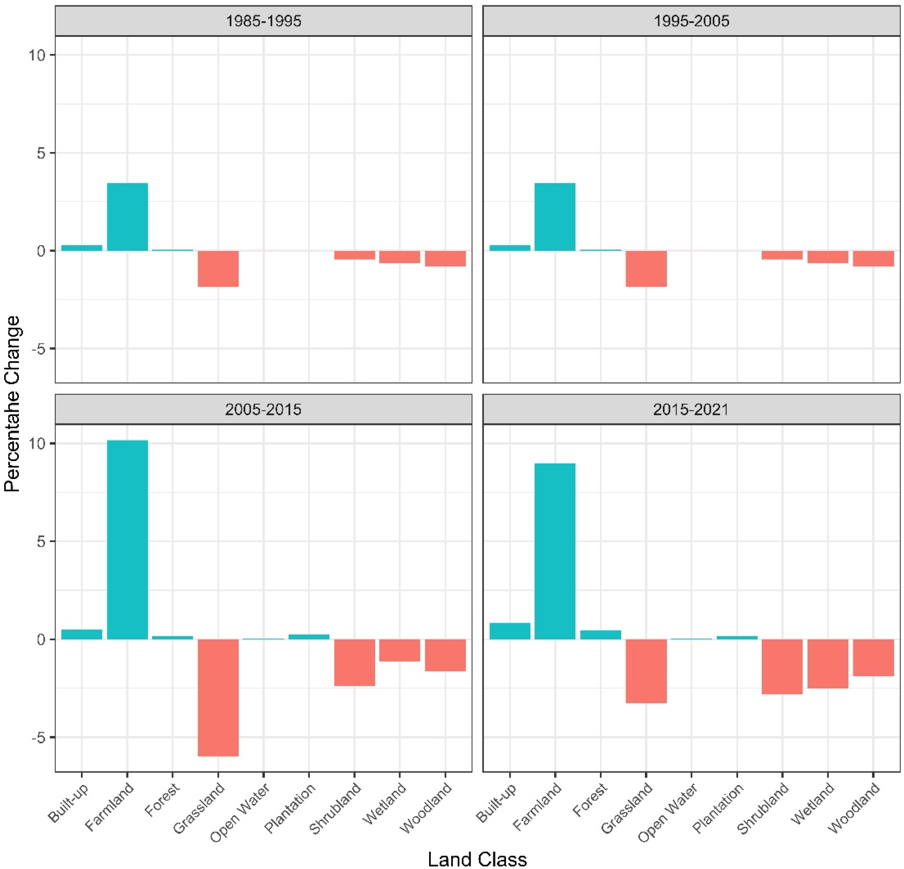
3.1. Land Use and Land Cover Changes in the Rangelands of Nakasongola District

A total of nine LULC classes were identified in the study area. These included built-up, farmland, forest, grassland, open water, shrub and thickets, tree plantation, wetland and woodlands (Figure 2 below).
Results of the land cover and land cover analysis from 1985 to 2021 indicated that the rangelands in Nakasongola district had been subjected to significant LULC changes. In 1985, grasslands were the dominant LULC class (31.7%), followed by wetlands (26.4%), shrubs and thickets (16.4%), woodland (11.5%) and farmlands (7.2%) (Table 2 below). Tree plantations were non-existent in the study area up to 2005. In 2021, farmland was the dominant LULC class (35.8%) having increased fourfold from 7.2% in 1985. This was followed by wetland (21.6%), grassland (18.5%) and shrub and thicket (8.1%) (Table 2 below).
The results showed that there were gains in farmland, built-up, central forest reserves and tree plantations while losses were observed in woodland, shrub and thicket, grassland and wetland cover (Figure 3). Between 1985 and 2021, the total land area under grassland registered a net decline of −13.3%, shrub and thicket −8.3%, woodland −5.2% and wetland −4.8%. Farmland increased by 28.6%, built-up area by 1.7%, central forest reserves by 0.6% and open water by 0.1% (Figure 3).
The largest loss observed in grassland cover between 2005 and 2015 (−6%) coincided with the highest gain in farmland cover (10.2%) over the same period (Figure 3). The largest decline in wetland (−2.5%), shrub and thicket (−2.8%) and woodland (−1.9%) were all observed between 2015 and 2021. Wetland mainly converted to farmland and grassland, woodland to farmland and grassland, shrub and thicket to farmland and grassland.

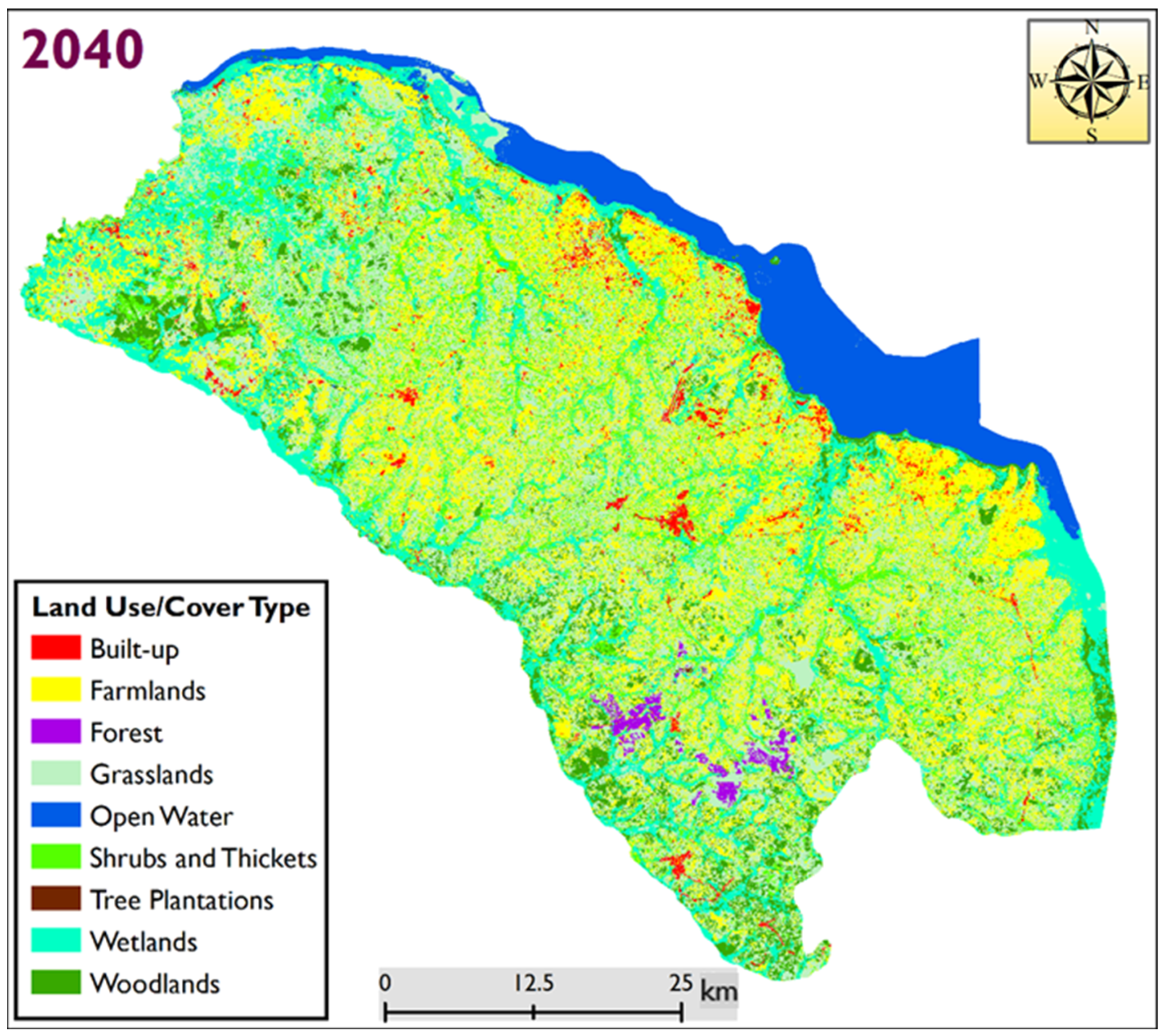
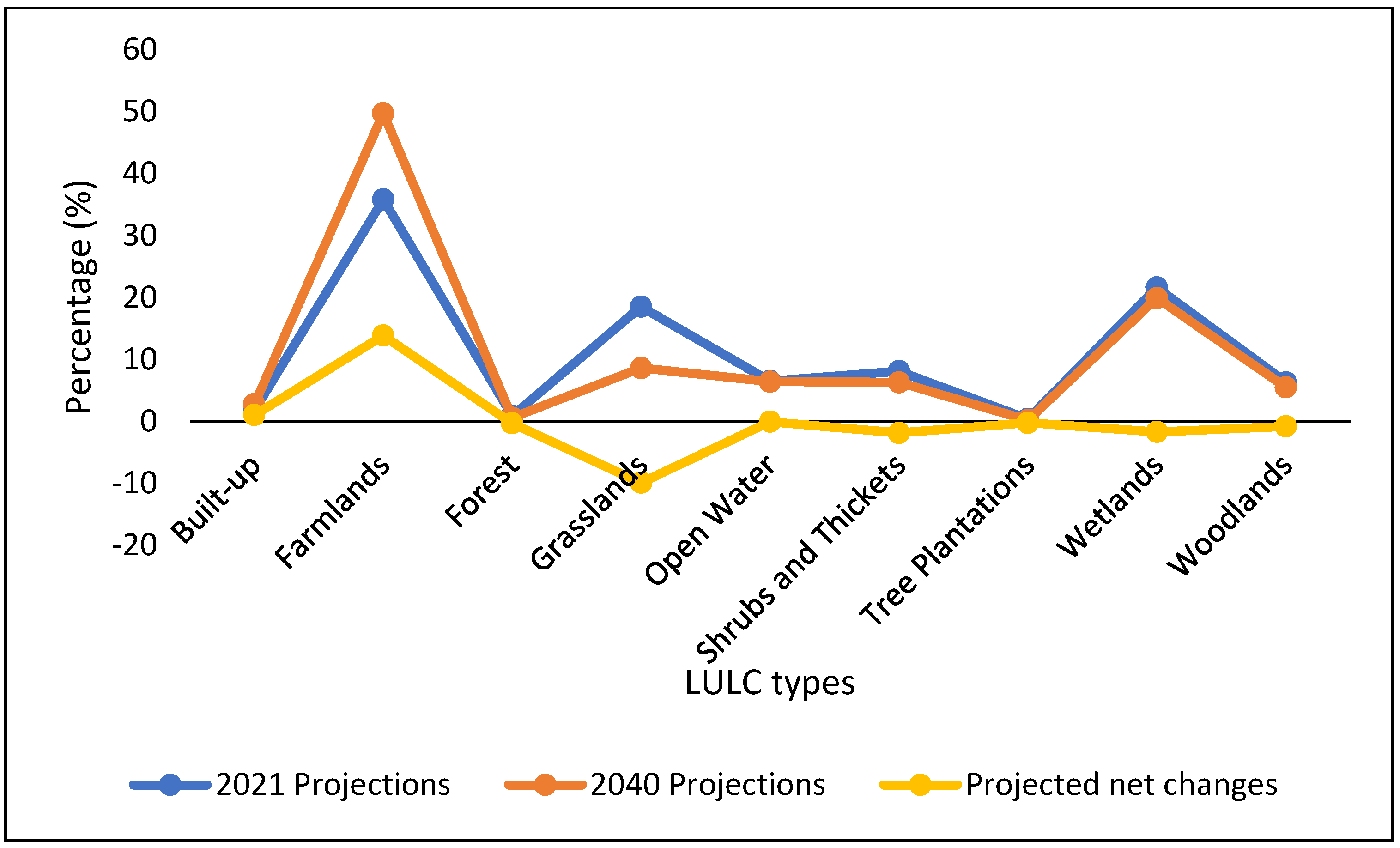
3.2. Prejocted LULC Changes in Nakasongola District Rangelands

The current nine LULC types observed in the rangelands of Nakasongola district are projected to change (Appendix C, Table A3). The largest part of Nakasongola district (49.7%) is likely to be covered by farmlands in 2040 (Figure 4). Land under grasslands, open water, shrubs and thickets and woodlands cover will all have decreased by the year 2040. The largest decline (−9.89%) will be observed in grassland cover, while farmlands will increase by 13.85% (Figure 5).

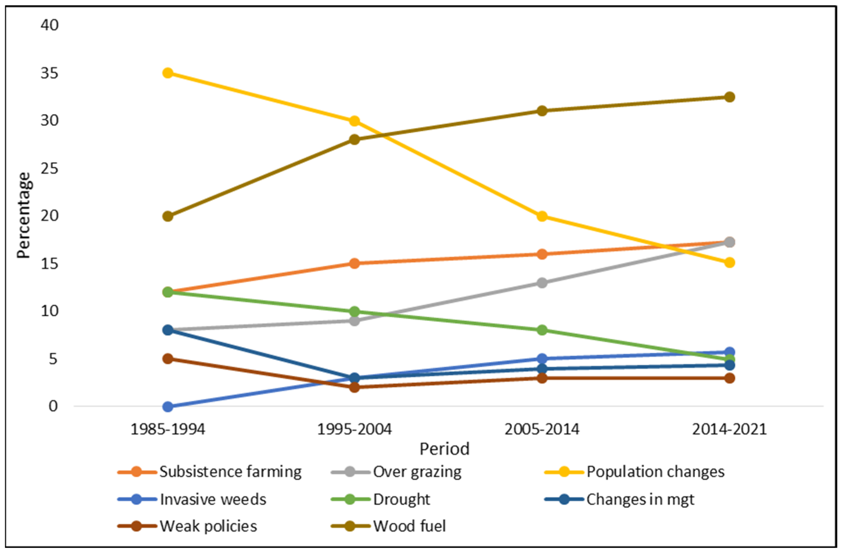
3.3. Perceived Drivers of LULC Changes in the Study Area

Responses from the local community revealed a total number of nine perceived drivers of LULC change in the rangelands of Nakasongola district between 1985 and 2021 (Figure 6). The change in the local population (35%) was perceived as the biggest contributor of LULC changes for the period 1985994. This was followed by the increase in wood fuel extraction (20%), subsistence farming (12%) and drought (12%). Between 1995 and 2004, changes in the population (30%), wood fuel extraction (28%) and subsistence farming were still the drivers of LULC changes in this area. Within the period 2005–2014, wood fuel extraction (31%) was perceived to have emerged as the leading driver of LULC changes in the rangelands of Nakasongola district followed by the local population changes (20%), the rise in subsistence farming (20%) and livestock grazing rates (13%). In the more recent period of 2014–2021, the dominant drivers of LULC changes in the rangelands of Nakasongola district were perceived to be the increased rates of wood fuel extraction (32.5%), overgrazing (17.2%) and subsistence farming (17.2%). Other factors included increased drought occurrences, increased invasive-plant weeds, weak government policies and change of rangeland management regimes from communal ownership to private ownership.
Owing to the patterns of LULC change and the perceived orchestrating drivers, participants noted with concern the evolution of associated effects of these changes. These effects included among others: sufficient pasture and browse for livestock (20.7%), increased crop failure and hunger (17.9%), changing climate patterns with extreme events especially prevalence of drought (15%) and increased water scarcity (13.6%) (Appendix D, Figure A1). Further, participants observed that livestock herd size and composition had changed, livestock losses due to drought and disease were common, low livestock productivity especially in terms of milk, and declining biodiversity and natural habitats for wildlife.

4. Discussion

4.1. Land Use and Land Cover Changes in Nakasongola Rangelands

This study has revealed large LULC in Nakasongola district. The most critically affected LULC are grasslands, wetlands and woodlands. These have declined over time and are projected to decline in the near future. On the other hand, farmlands, built-up area and planted forest have increased. Rapid reductions in the total land area under grassland cover observed in the current study have been reported by earlier studies conducted in the study area [22,36]. But unlike in the current study, where the grasslands were overtaken by farmlands as the dominant land cover type, grasslands remained as the most dominant land cover type in Karamoja [35]. In agreement with the findings of the current study, [46] there was a reported tenfold increase of farmlands in Karamoja sub-region.
There is growing evidence showing that there has been extensive conversion of rangelands land cover types such as grasslands, woodlands and wetlands into farmlands in Eastern Africa in the past three decades [47,48]. For instance, farmlands increased by 171.2% in Ethiopia’s Bale zone [49] and in Borana rangelands of Southern Ethiopia [50].
Based on the observations from this study, it is apparent that crop farming is currently dominant in Nakasongola district. This implies that the patterns of land use and livelihoods are changing from mere dependence on grasslands to other forms like farming and settlements.
Although the dominance of shrubs and thickets in the majority of East African rangelands has been associated with resilience to the increasing drought events [51], the current study reported a declining trend in their cover. These findings were contrary to previous studies that have reported an increasing trend in shrubs and thickets cover in the rangelands of East Africa [12,50,51]. It is possible that shrubs and thickets have been transformed by other overarching land use and land cover types like farmlands.
The observed decline in woodlands within the rangelands of Nakasongola have also been reported in rangelands in other parts of Uganda. Egeru [46] reported a 3.9% decline in the total land area under woodland cover in the rangelands of the Karamoja sub-region of Uganda between 1986 and 2013. Similarly, a decline of 13.9% was reported in woodland cover in the drylands of Eastern Uganda [52]. In other parts of East Africa such as the Northern Afar rangelands in Ethiopia, a woodland cover reduction of up to 97% has been reported [17].
In the current study, planted forests were on the rise. The increase in land area under forest cover in Nakasongola district might be explained by the fact that forest reserves in the area including Kasangala, Katugo and Wabisi-wajala Central Forest Reserves are periodically reforested with coniferous trees including pine trees and eucalyptus. Similarly, previous studies have reported the increasing adoption of agroforestry practices as a drought adaptation strategy in the study area [23].This could have significantly contributed to the increased proportion of land under planted forests in Nakasongola district during the 1985–2021 period.
The increase in the open water cover type in the 1990s corresponds well with periods like 1997/1998 when unusually heavy rainfall amounts are reported over most parts of Uganda [53] and East Africa [54]. On the other hand, the years 1986 and 1993 have also been recorded as drought years that reduced water levels in Lake Kyoga basin which is the major open water body covering the study area [55]. Therefore, the decline in the open water cover in the study area during the 1986–1995 could be linked to the droughts recorded during these years. Elsewhere in the rangelands of East Africa, increased rates of built-up land cover types have been reported [12]. This has not only been related to the increasing population of pastoral and agro-pastoral households in the rangeland, but also the increasing practice of sedentary lifestyles [56].
Findings of this study observed a declining trend in wetland cover for the study period. This was contrary to the earlier findings by [22] that reported an increase in the wetlands in the study area.

4.2. Drivers of LUCL Changes

The perceived drivers of LULC changes in the rangelands of Nakasongola can broadly be categorized as biophysical, demographic, economic, infrastructural and technological. These include wood fuel, changed rangeland management regimes, population increase, drought and subsistence farming. Similar findings have been reported by [17] in Northern Afar rangelands in Ethiopia.
Indeed, both regional [12,17] and global perspectives [57] on the high rates of decline in grassland cover in the rangelands is attributed to the transformation of built-up areas, crop farms and bush encroachment. Wood fuel extraction emerged as the key driver of LULC change in rangelands of Nakasongola because of the high level of tree loss that the local community has observed overtime. Trees from woodlands, grasslands and wetlands were reported to be mainly cleared by farmers and other community members who engage in the lucrative business of charcoal burning and sale of firewood; and this had been exacerbated by changes in property rights from communal to individual ownership. This is in line with findings from Kiringe [58] that showed that the Maasai community in communal rangelands around Amboseli in Kenya perceived high rates of tree loss due to increased charcoal burning.
As denoted by [59,60], it is possible that increasing incidents of drought and livestock loss have forced formerly livestock dependent households to diversify their economies with the adoption crop cultivation. This could be the reason for the observed proliferation of the farmlands in the current study.
Similarly, recurrent droughts, population increase and expansion of crop cultivation were also reported as major drivers of LULC changes in Borana rangelands in Southern Ethiopia [50].
The perceptions of increase in population coincide with the demographic data of Nakasongola district showing that the population in the area increased from 100,497 people in 1991, to 127,064 in 2002 and 181,863 in 2014 [61]. Demographic factors like human population growth come along with the increased demand for crop cultivation land which might lead to significant changes in LULC types in the rangelands [50]. No wonder local communities in Nakasongola district perceived population growth as a major underlying drive for the conversion of land under woodlands, grasslands and wetlands in the 1990s. The 1990s immigration of people from Lango region into Nakasongola district were linked with exerting pressure on some forests, woodlands and wetlands for settlement and crop farming. This confirms earlier findings showing that most of the woodlands in the rangelands of East Africa have been lost to subsistence farming and collection of wood fuel including charcoal and firewood collection [47]. Similarly, Mwavu and Witkowski [62] reported that population growth and agricultural expansion led to the loss of 8.2% of forested land in Budongo forest to sugarcane cultivation. Similar findings were reported by [63] for Bwindi Forest Reserve.
But the local community indicated that the current rate of wood fuel extraction, livestock grazing and farming have superseded the influence population growth had on the rangelands of Nakasongola in the 1980s. These findings deviate from the findings of Dika [43] that showed that Boorana pastoralists perceived a continuous increase in rangeland degradation in the rangelands of Southern Ethiopia due to increasing population growth. This finding points to the fact that the drivers of rangeland change in Nakasongola district have changed overtime.
The changes in management regime from communal to individualized ownership and weak policies were cited as key factor for rangeland degradation in the current study. Similarly, weak policies that promote appropriation of rangelands for development purposes, such as the establishment of industrial parks, have had impacts on some land over types such as wetlands, woodlands and grasslands [64]. The historical marginalization of pastoral groups such as the Karamojong and agricultural agendas are widely associated with the appropriation of rangelands for agricultural expansion [65,66]. Currently, initiatives such as the Karamoja Development Plan that aim at increasing mineral exploration and investment in Karamoja region [67] might drive some LULC changes in the area. Elsewhere, local communities from the Southern Afar Region of Ethiopia indicated that policies that promote sedentary agriculture and allocate land to external investors had resulted in the reduction in rangelands and the expansion of crop farms [29]. Similarly, unclear property rights significantly affects the efficient and sustainable utilization of rangeland resources by the local communities [68]. In Nakasongola the influence of weak policies was still not yet so significant because the local community members indicated that only a few proportions of the rangelands were reported to have been so far allocated to investors for industrialization and other purposes.
Although the proliferation of crop farming in the rangelands of East Africa might have largely been driven by policy and development agendas, scholars such as [69] have argued that recent participation in non-pastoral activities is a cognitive response to the changing environment or as a result of natural response to new challenges or realized opportunities in the rangelands. This points to the need to understand whether the choice of local communities within the rangelands of Nakasongola to participate in non-pastoral activities such as crop farming is made on an individual basis or if they are being coerced into it as a last resort due to unfavorable rangeland management policies.
Drought has been linked with causing largescale destruction of vegetation cover in the rangelands [70,71]. During drought years farmers tend to overexploit certain land cover types such as wetlands and forested areas by clearing them for the establishment of crop farming and sometimes for charcoal burning [70] Wetlands and woodlands are also overgrazed with livestock during drought years, yet overgrazing promotes bush encroachment and change in plant species composition in rangeland [64,72]. According to [73], overgrazing has an impact on both the rangeland vegetation health and soil conditions such as soil organic carbon (SOC) and bulk density, especially around heavily grazed areas such as drinking points. Siyabulela [73] observed that commercial farms with higher stoking rates had supported lower rates of SOC compared to communal grazed farms with the same stocking rates. Indeed, rangelands in Uganda are continuously associated with overgrazing yet they are already labelled as amongst the most fragile ecosystems prone to degradation [52,74]. Therefore, there is a need to regulate the grazing intensity during the drought years and around key resources such as watering points in order to maintain the supply of environmental services such as pasture and water resource provisioning from the rangelands.
Increasing drought incidences have been associated with the proliferation of invasive weed species such as Prosopis juliflora and Latana camara that have rapidly changed the structure of rangelands in Eastern Africa [75,76]. Owing to invasive species such as Prosopis juliflora and Latana camara, previously grassland dominated rangelands in most parts of Eastern Africa such as Ethiopia, Kenya and Uganda have been highly encroached by bush and shrub vegetation [75,76]. Similarly, Mekuyie [29] denoted that the drastic increase in bush and shrubs cover on the rangelands of the Southern Afar region of Ethiopia was largely comprised of the alien invasive Prosopis juliflora species. The proliferation of alien invasive bushes and shrubs bears negative impacts on both the rangeland ecosystems and socio-economic aspects of the country like Uganda and Ethiopia.

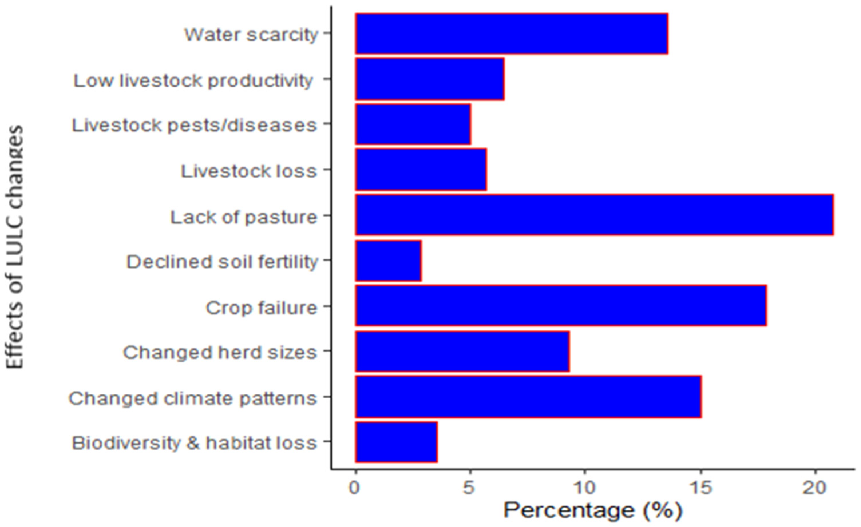
4.3. Impacts of LUCL Changes the Local Community

The clearance of woodlands and grasslands for crop farming and wood fuel may result in a loss of biodiversity in the study area and the disappearance of some preferred forage species and natural habitats of wildlife. Elsewhere, [17] attributed the decline in forage diversity and shrinkage of grazing land in the rangelands of Northern Afar to the proliferation of cropping land and clearance of vegetation. But the decline in grazing land in Nakasongola rangelands was also exacerbated by the loss of traditional communal grazing land to private land and enclosures. Nonetheless, private enclosures have been associated with encouraging overgrazing by farmers thereby leading to vegetation cover loss and rangeland degradation [77].
The local community members in the rangelands of Nakasongola also reported challenges of changing climate patterns that had increased the occurrence of extreme whether events such as droughts. This is in line with earlier findings from [12] who reported the increased occurrence of droughts in the study area. Challenges such as water scarcity, reduced livestock production and crop failure were cited as a result of increasing drought incidences in the study area. Frequent droughts have largely been associated with affecting water resource availability, crop and livestock production and increasing livestock pests and disease among pastoral and agro-pastoral households in the rangelands of Kenya [75]. Similar findings have been reported amongst pastoral and agro-pastoral households in the rangelands of Ethiopia [18,51].
The reduction in herd size and composition is both directly and indirectly related to the decline in grazing land, the lack of water resources and livestock pests and disease. The change in livestock composition from cattle to small livestock such as sheep and goats has been reported as a drought coping strategy among pastoral and agro-pastoral households [18,60]. Equally, herd size reduction has been evident where the rangeland vegetation structure has been reported to have changed from good pastures of unpalatable shrubby vegetation [78]. Earlier studies have reported declines in herd sizes of pastoralists owing to sedentarization and the loss of their previously communally grazed land to private enclosures [17,79]. Therefore, the reduction in herd size amongst pastoral and pastoral households in the rangeland of Nakasongola could be an indication of both shrunken grazing land due to LULC changes and increasing drought effects. Authors should discuss the results and how they can be interpreted from the perspective of previous studies and of the working hypotheses. The findings and their implications should be discussed in the broadest context possible. Future research directions may also be highlighted.

4.4. Implications for Rangeland Management

Monitoring rangeland land use and land cover dynamics is an important process for providing information on ongoing interactions between humans and their environment. In this way, the information obtained can be used to support proper land use planning for rangeland management and livelihood support. Historically, grasslands were the most dominated LULC type followed by wetlands, shrub and thicket, woodland and farmlands. Presently, farmlands are the most dominant followed by wetlands, grasslands and shrubs and thicket. Future wetland conservation and agro-forestry processes might be driven by the unsustainable expansion of subsistence farming in the area unless, wetland encroachment is controlled.
This observed trend in LULC change is likely to promote the degradation of the rangelands in Nakasongola unless measures aimed at averting this trend are put in place. Therefore, any interventions put in place should aim at limiting the negative effects of each of the key drivers such as population changes and drought on the most affected LULC types. For instance, grasslands being prone to overgrazing more than any other LULC classes calls for an intervention that protects them from being degraded by this particular driver. Moreover, overgrazing has been associated with clearing grasslands’ vegetation and leaving them prone to other dangerous natural process such as soil erosion [80]. It is reported that the overstocking of livestock affects soil physico-chemical properties hence causing significant variations in seasonal forage composition and availability in the rangelands [39,46].
Wetlands are vulnerable to encroachment from the increasing subsistence farming activities while woodlands are more prone to high extraction rates for wood fuel. Equally, grasslands and woodlands also seem to be over exploited during the dry seasons and in drought years pastorals are. Therefore, national and regional development plans that aim at promoting agriculture should not leave a scar. In particular, the commercialization of agriculture that looks at intensification might indirectly have negative effects on rangelands if more land cover types are opened up for subsistence farming through processes such as woodland destruction.

5. Conclusions

The objective of this study was to determine land use and land cover change dynamics and perceived drivers of LULC in the Central Uganda district of Nakasongola through the integration of remote sensing and local community perceptions. Our results revealed that the rangelands in Nakasongola district had undergone change of some LULC types such as grassland, wetland and grasslands decline, while farmland and built-up areas increased. LULC types such as farmlands and built-up areas were responsible for significant declines observed in grasslands and woodlands. By 2040, the most dominant land use and cover type is expected to be farmland with a significant decline in grassland cover.
Based on the local community perceptions, the drivers of the observed LULC were multidimensional including demographic, climatic factors, subsistence farming, policy and wood fuel extraction. The classification of land use and land cover types in rangelands of Nakasongola district has helped in developing information for rangeland land use and management planning nationally and regionally. The findings underpin the importance of integrating both the conventional methods of remote sensing and community perceptions in understanding land use and land cover change dynamics in the rangelands of Central Uganda. The study recommends that a holistic approach involving a combination of conventional methods like remote sensing and community knowledge should be adopted in understanding land use and land cover change dynamics and developing appropriate interventions aimed at realizing better rangeland health and management in Uganda.

Author Contributions

Writing—original draft preparation, formal analysis, D.A.K.; Conceptualization, D.A.K., A.E., K.N. and J.R.S.T.; Writing—review and editing, D.A.K., A.E., K.N. and J.R.S.T.; Supervision A.E., K.N. and J.R.S.T.; Methodology, data curation, software, visualization, investigation, I.T.O., B.S., P.J.M. and G.Y.M.; Resources, B.S. All authors have read and agreed to the published version of the manuscript.

Funding

This research was funded by UK Research & Innovation (UKRI) through the Global Challenges Research Fund (GCRF) programme, Grant Ref: ES/P011306/1 under the project Social and Environmental Trade-offs in African Agriculture (SENTINEL) led by the International Institute for Environment & Development (IIED) in part implemented by the Regional Universities Forum for Capacity Building in Agriculture (RUFORUM).

Institutional Review Board Statement

Not applicable.

Informed Consent Statement

Informed consent was obtained from all subjects involved in the study.

Data Availability Statement

Satellite images for 1985, 1995, 2005, 2015 and 2021 for Nakasongola district were downloaded from the USGS Earth explorer website (https://earthexplorer.usgs.gov/, accessed on 15 January 2022).

Acknowledgments

The authors of this work would like to extend their sincere gratitude to the Regional Universities Forum for Capacity Building in Agriculture (RUFORUM) for providing the financial support for this research under their SETINELS program.

Conflicts of Interest

The authors declare no conflict of interest.

Appendix A

Table A1. Details of satellite images for Nakasongola district for 1985, 1995, 2005, 2015 and 2021.
YearLandsat Scene
Number
SatellitePathRowAcquisition DateSensor
1985LT51720591985014XXX01Landsat 51725914 January 1985TM
LT51710591985103XXX04Landsat 51715913 April 1985TM
1995LT51720591995010XXX01Landsat 51725910 January 1995TM
LT51710591995003XXX01Landsat 5171593 January 1995TM
2005LE71720592005045ASN00Landsat 71725914 February 2005ETM
LE71710592005038ASN00Landsat 7171597 February 2005ETM
2015LC81720592015017LGN01Landsat 81725917 January 2015OLI_TIRS
LC81710592015010LGN01Landsat 81715910 January 2015OLI_TIRS
2021LC81720592021033LGN00Landsat 8172592 February 2021OLI_TIRS
LC81710592021026LGN00Landsat 81715926 January 2021OLI_TIRS

Appendix B

Table A2. Producer’s accuracy, User’s accuracy and overall accuracy for the different land use and land cover types in Nakasongola district in 1985, 1995, 2005, 2015 and 2021.
Year19851995200520152021
LULC TypeProducer’s AccuracyUser’s
Accuracy
Producer’s AccuracyUser’s
Accuracy
Producer’s AccuracyUser’s
Accuracy
Producer’s AccuracyUser’s AccuracyProducer’s AccuracyUser’s
Accuracy
Built-up89.584.979.776.265.864.282.280.873.971.6
Farmlands74.176.977.175.485.283.478.472.780.477.1
Forest91.887.486.384.984.886.189.687.385.283.8
Grasslands78.379.169.670.876.573.985.187.975.574.7
Open Water95.894.987.485.586.884.384.283.786.885.3
Shrubs and Thickets63.961.567.872.361.667.777.275.871.268.9
Tree
Plantations
78.376.982.981.576.174.8
Wetlands84.682.686.183.786.284.875.371.663.365.6
Woodlands86.785.183.279.675.675.182.480.176.775.2
Overall
Accuracy
81.778.682.384.579.8

Appendix C

Table A3. Projected LULC types for 2040 in Nakasongola rangelands.
20212040Projected Net Change (2021–2040)
Land Use and Land Cover TypeArea (Sq∙km)Area (Sq∙km)Area (Sq∙km)
Built-up62.898.535.7
Farmlands1257.11743.2486.1
Forest31.119.9−11.2
Grasslands648.3301.2−347.1
Open Water227.4225.3−2.1
Shrubs and Thickets285.6220.3−65.3
Tree Plantations15.67.6−7.9
Wetlands758.7699.1−59.7
Woodlands221.9193.5−28.4
Total3508.63508.6

Appendix D

Figure A1. Perceived impacts of LULC changes in the rangelands of Nakasongola district.
Land 11 01402 g0a1

References

  1. Lipper, L.; Dutilly-Diane, C.; Mccarthy, N. Supplying Carbon Sequestration From West African Rangelands: Opportunities and Barriers. Rangel. Ecol. Manag. 2010, 63, 155–166. [Google Scholar] [CrossRef]
  2. Reynolds, J.F.; Smith, D.M.S.; Lambin, E.F.; Turner, B.L.; Mortimore, M.; Batterbury, S.P.; Downing, T.E.; Dowlatabadi, H.; Fernández, R.J.; Herrick, J.E.; et al. Global desertification: Building a science for dryland development. Science (80-.) 2007, 316, 847–851. [Google Scholar] [CrossRef] [PubMed]
  3. McGahey, D.; Davies, J.; Hagelberg, N.; Ouedraogo, R. Pastoralism and the Green Economy, a Natural Nexus? Status, Challenges and Policy Implications; International Union for Conservation of Nature and Natural Resources, United Nations Environment Programme: Nairobi, Kenya, 2014; Available online: https://portals.iucn.org/library/sites/library/files/documents/2014-034.pdf (accessed on 25 June 2022).
  4. Davies, J.; Ouedraogo, R.; Hagelberg, N. Sustainable Pastoralism and the Post 2015 Agenda. 2014. Available online: http://iucn.org/es/ (accessed on 25 June 2022).
  5. Fratkin, E. East African Pastoralism in Transition: Maasai, Boran, and Rendille Cases. Afr. Stud. Rev. 2008, 44, 1–25. [Google Scholar] [CrossRef]
  6. Galvin, K.A. Transitions: Pastoralists Living with Change. Annu. Rev. Anthropol. 2009, 38, 185–198. [Google Scholar] [CrossRef]
  7. Egeru, A.; Osaliya, R.; MacOpiyo, L.; Mburu, J.; Wasonga, O.; Barasa, B.; Said, M.; Aleper, D.; Majaliwa Mwanjalolo, G.J. Assessing the spatio-temporal climate variability in semi-arid Karamoja sub-region in north-eastern Uganda. Int. J. Environ. Stud. 2014, 71, 490–509. [Google Scholar] [CrossRef]
  8. Hobbs, N.T.; Galvin, K.A.; Stokes, C.J.; Lackett, J.M.; Ash, A.J.; Boone, R.B.; Reid, R.S.; Thornton, P.K. Fragmentation of rangelands: Implications for humans, animals, and landscapes. Glob. Environ. Chang. 2008, 18, 776–785. [Google Scholar] [CrossRef]
  9. Bedunah, D.J.; Angerer, J.P. Rangeland degradation, poverty, and conflict: How can rangeland scientists contribute to effective responses and solutions? Rangel. Ecol. Manag. 2012, 65, 606–612. [Google Scholar] [CrossRef]
  10. Lambin, E.F.; Turner, B.L.; Geist, H.J.; Agbola, S.B.; Angelsen, A.; Bruce, J.W.; Coomes, O.T.; Dirzo, R.; Fischer, G.; Folke, C.; et al. The causes of land-use and land-cover change: Moving beyond the myths. Glob. Environ. Chang. 2001, 11, 261–269. [Google Scholar] [CrossRef]
  11. Mccarthy, N.; Swallow, B.; Kirk, M. Property Rights, Risk, and Livestock Development in Africa; Public Policy; International Livestock Research Institute: Nairobi, Kenya; International Food Policy Research Institute: Washington, DC, USA, 2000. [Google Scholar]
  12. Mohammed, M.; Habtamu, T.; Yared, M. Land use/cover change analysis and local community perception towards land cover change in the lowland of Bale rangelands, Southeast Ethiopia. Int. J. Biodivers. Conserv. 2017, 9, 363–372. [Google Scholar] [CrossRef]
  13. Xu, Y.; Yu, L.; Zhao, F.R.; Cai, X.; Zhao, J.; Lu, H.; Gong, P. Tracking annual cropland changes from 1984 to 2016 using time-series Landsat images with a change-detection and post-classification approach: Experiments from three sites in Africa. Remote Sens. Environ. 2018, 218, 13–31. [Google Scholar] [CrossRef]
  14. Ordway, E.M.; Asner, G.P.; Lambin, E.F. Deforestation risk due to commodity crop expansion in sub-Saharan Africa. Environ. Res. Lett. 2017, 12, 044015. [Google Scholar] [CrossRef]
  15. Srivastava, A.; Kumari, N.; Maza, M. Hydrological response to agricultural land use heterogeneity using variable infiltration capacity model. Water Resour. Manag. 2020, 12, 3779–3794. [Google Scholar] [CrossRef]
  16. Aghsaei, H.; Dinan, N.M.; Moridi, A.; Delavar, M.; Fohrer, N.; Wagner, P.D. Effects of dynamic land use/land cover change on water resources and sediment yield in the Anzali wetland catchment, Gilan, Iran. Sci. Total Environ. 2020, 712, 136449. [Google Scholar] [CrossRef] [PubMed]
  17. Tsegaye, D.; Moe, S.R.; Vedeld, P.; Aynekulu, E. Land-use/cover dynamics in Northern Afar rangelands, Ethiopia. Agric. Ecosyst. Environ. 2010, 139, 174–180. [Google Scholar] [CrossRef]
  18. Tsegaye, D.; Vedeld, P.; Moe, S.R. Pastoralists and livelihoods: A case study from northern Afar, Ethiopia. J. Arid Environ. 2013, 91, 138–146. [Google Scholar] [CrossRef]
  19. National Environmental Management Authority (NEMA). National State of The Environment Report for Uganda 2012, Harnessing our Environment for Wealth Creation; NEMA: Kampala, Uganda, 2012; Available online: https://www.nema.go.ug/projects/reports (accessed on 27 October 2021).
  20. Kaggwa, R.; Hogan, R.; Hall, B. Enhancing the Contribution of Weather, Climate and Climate Change to Growth, Employment and Prosperity; UNDP/NEMA/UNEP Poverty Environment Initiative: Kampala, Uganda, 2009; Available online: https://wedocs.unep.org/bitstream/handle/20.500.11822/26899/Weather_growth.pdf?sequence=1&isAllowed=y (accessed on 25 June 2022).
  21. Mwanjalolo, M.G.J.; Bernard, B.; Paul, M.I.; Joshua, W.; Sophie, K.; Cotilda, N.; Bob, N.; John, D.; Edward, S.; Barbara, N. Assessing the extent of historical, current, and future land use systems in Uganda. Land 2018, 7, 132. [Google Scholar] [CrossRef]
  22. Zziwa, E.; Kironchi, G.; Gachene, C.; Mugerwa, S. The dynamics of land use and land cover change in Nakasongola district. J. Biodivers. Environ. Sci. 2012, 2, 61–73. [Google Scholar]
  23. Mfitumukiza, D.; Barasa, B.; Aringaniza, I. Determinants of agroforestry adoption as an adaptation means to drought among smallholder farmers in Nakasongola District, Central Uganda. African J. Agric. Res. 2017, 12, 2024–2035. [Google Scholar] [CrossRef]
  24. Obua, J.; Agea, J.G.; Namirembe, S.; Egadu, S.P. The Potential of Acacia senegal for Dryland Agroforestry and Gum Arabic Production in Uganda. J. Drylands 2006, 1, 186–193. [Google Scholar]
  25. Byakagaba, P.; Egeru, A.; Barasa, B.; Briske, D.D. Uganda’s rangeland policy: Intentions, consequences and opportunities. Pastoralism 2018, 8, 7. [Google Scholar] [CrossRef]
  26. Mbolanyi, B.; Egeru, A.; Mfitumukiza, D. Contribution of Rangelands to Household Food Basket and Income in a Pastoral Area in Uganda. J. Food Secur. 2016, 4, 68–75. [Google Scholar] [CrossRef]
  27. Sibanda, A.; Tui, S.H.K.; van Rooyen, A.; Dimes, J.; Nkomboni, D.; Sisito, G. Understanding community perceptions of land use changes in the rangelands, zimbabwe. Exp. Agric. 2011, 47, 153–168. [Google Scholar] [CrossRef] [Green Version]
  28. Guuroh, R.T.; Ruppert, J.C.; Ferner, J.; Čanak, K.; Schmidtlein, S.; Linstädter, A. Drivers of forage provision and erosion control in West African savannas—A macroecological perspective. Agric. Ecosyst. Environ. 2018, 251, 257–267. [Google Scholar] [CrossRef]
  29. Mekuyie, M.; Jordaan, A.; Melka, Y. Land-use and land-cover changes and their drivers in rangeland-dependent pastoral communities in the southern Afar Region of Ethiopia. African J. Range Forage Sci. 2018, 35, 33–43. [Google Scholar] [CrossRef]
  30. Dobbie, M.; Green, R. Public perceptions of freshwater wetlands in Victoria, Australia. Landsc. Urban Plan. 2013, 110, 143–154. [Google Scholar] [CrossRef]
  31. Schaich, H. Local residents’ perceptions of floodplain restoration measures in Luxembourg’s Syr Valley. Landsc. Urban Plan. 2009, 93, 20–30. [Google Scholar] [CrossRef]
  32. Egeru, A. Role of Indigenous Knowledge in Climate Change Adaptation: A case study of the Teso Sub-Region, Eastern Uganda. Indian J. Tradit. Knowl. 2012, 11, 217–224. [Google Scholar]
  33. Saylor, C.R.; Alsharif, K.A.; Torres, H. The importance of traditional ecological knowledge in agroecological systems in peru. Int. J. Biodivers. Sci. Ecosyst. Serv. Manag. 2017, 13, 150–161. [Google Scholar] [CrossRef]
  34. Tarakini, T.; Guerbois, C.; Wencelius, J.; Mundy, P.; Fritz, H. Integrating Local Ecological Knowledge for Waterbird Conservation: Insights From Kavango-Zambezi Transfrontier Conservation Area, Zimbabwe. Trop. Conserv. Sci. 2018, 11. [Google Scholar] [CrossRef]
  35. Egeru, A.; Wasonga, O.; Majaliwa Mwanjalolo, G.J.; MacOpiyo, L.; Mburu, J. Dynamics of land use and land cover change in semi-arid Karamoja sub-region, Uganda. In Proceedings of the RUFORUM Fourth Biennial Conference, Maputo, Mozambique, 19–25 July 2014; pp. 125–132. [Google Scholar]
  36. Mbaziira, J. Land cover and land use change analysis: Its impacts on rangeland ecosystems in Kakooge County, Nakasongola district. J. Sci. Sustain. Dev. 2019, 6, 167–180. [Google Scholar] [CrossRef]
  37. Behn, K.; Becker, M.; Burghof, S.; Möseler, B.M.; Willy, D.K.; Alvarez, M. Using vegetation attributes to rapidly assess degradation of East African wetlands. Ecol. Indic. 2018, 89, 250–259. [Google Scholar] [CrossRef]
  38. Nimusiima, A.; Basalirwa, C.P.K.; Majaliwa, J.G.M. Nature and dynamics of climate variability in the uganda cattle corridor. African J. Environ. Sci. Technol. 2013, 7, 770–782. [Google Scholar] [CrossRef]
  39. Egeru, A.; Wasonga, O.; Mburu, J.; Yazan, E.; Majaliwa, M.G.J.; Macopiyo, L. Drivers of forage availability: An integration of remote sensing and traditional ecological knowledge in Karamoja sub-region, Uganda. Pastor. Res. Policy Pract. 2015, 5, 19. [Google Scholar] [CrossRef] [Green Version]
  40. Nsubuga, F.N.W.; Namutebi, E.N.; Nsubuga-ssenfuma, M. Water Resources of Uganda: An Assessment and Review. J. Water Resour. Prot. 2014, 6, 1297–1315. [Google Scholar] [CrossRef]
  41. National Forestry Authority (NFA). National Biomass Study, Phase I; NFA: Kampala, Uganda, 1992. [Google Scholar]
  42. Ramsar Convention Secretariat. Global Wetland Outlook: State of the World’s Wetlands and Their Services to People 2018; SSRN: Gland, Switzerland, 2018. [Google Scholar]
  43. Dika, G.; Tolossa, D.; Eyana, S.M. Rangeland Degradation and Its Impacts Post-1992: Constructing the Perceptions of Boorana Pastoralist, Southern Ethiopia. Int. J. Ecol. 2022, 2022, 7978744. [Google Scholar] [CrossRef]
  44. Subedi, P.; Subedi, K.; Thapa, B. Application of a Hybrid Cellular Automaton—Markov (CA-Markov) Model in Land-Use Change Prediction: A Case Study of Saddle Creek Drainage Basin, Florida. Appl. Ecol. Environ. Sci. 2013, 1, 126–132. [Google Scholar] [CrossRef]
  45. Rasolofoson, R.A.; Nielsen, M.R.; Jones, J.P.G. The potential of the Global Person Generated Index for evaluating the perceived impacts of conservation interventions on subjective well-being. World Dev. 2018, 105, 107–118. [Google Scholar] [CrossRef]
  46. Egeru, A.; Wasonga, O.; Kyagulanyi, J.; Majaliwa, G.; MacOpiyo, L.; Mburu, J. Spatio-temporal dynamics of forage and land cover changes in Karamoja sub-region, Uganda. Pastor. Res. Policy Pract. 2014, 4, 6. [Google Scholar] [CrossRef]
  47. Olson, J.M.; Misana, S.; Campbell, D.J.; Mbonile, M.; Mugisha, S. A Research Framework to Identify the Root Causes of Land Use Change Leading to Land Degradation and Changing Biodiversity; International Livestock Research Institute: Nairobi, Kenya, 2004; Volume 48. [Google Scholar]
  48. Maitima, J.; Olson, J.; Mugatha, S.; Mugisha, S.; Mutie, I. Land use changes, impacts and options for sustaining productivity and livelihoods in the basin of lake Victoria. J. Sustain. Dev. Africa 2010, 12, 1520–5509. [Google Scholar]
  49. Legese, B.; Balew, A. Land-use and land-cover change in the lowlands of Bale Zone, Ethiopia: Its driving factors and impacts of rangeland dynamics in livestock mobility. Environ. Monit. Assess. 2021, 193, 453. [Google Scholar] [CrossRef]
  50. Abate, T.; Angassa, A. Conversion of savanna rangelands to bush dominated landscape in Borana, Southern Ethiopia. Ecol. Process. 2016, 5, 1–18. [Google Scholar] [CrossRef] [PubMed]
  51. Witt, A.; Shackleton, R.T.; Witt, A.B.R.; Aool, W.; Pratt, C.F.; Shackleton, R.T.; Witt, A.B.R.; Aool, W.; Pratt, C.F. Distribution of the invasive alien weed, Lantana camara, and its ecological and livelihood impacts in eastern Africa. African J. Range Forage Sci. 2017, 34, 1–11. [Google Scholar] [CrossRef]
  52. Egeru, A.; Okello, P.; Majaliwa, M.; Mukwaya, P.; Isubikalu, P. The Effect of Land use/cover change on Biomass Stock in Dryland Areas of Eastern Uganda. A case study of Olio Sub-county in Soroti District. J. Appl. Sci. Environ. Manag. 2011, 14. [Google Scholar] [CrossRef]
  53. Hisali, E.; Birungi, P.; Buyinza, F. Adaptation to climate change in Uganda: Evidence from micro level data. Glob. Environ. Chang. 2011, 21, 1245–1261. [Google Scholar] [CrossRef]
  54. Ongoma, V.; Chen, H.; Omony, G.W. Variability of extreme weather events over the equatorial East Africa, a case study of rainfall in Kenya and Uganda. Theor. Appl. Climatol. 2018, 131, 2018. [Google Scholar] [CrossRef]
  55. Nsubuga, F.W.N.; Botai, O.J.; Olwoch, J.M.; Rautenbach, C.J.d.; Bevis, Y.; Adetunji, A.O. The nature of rainfall in the main drainage sub-basins of Uganda. Hydrol. Sci. J. 2014, 59, 278–299. [Google Scholar] [CrossRef]
  56. Flintan, F. The Political Economy of Land Reform in Pastoral Areas: Lessons from Africa, Implications for Ethiopia. In Proceedings of the International Conference one on the Future of Pastoralism, Addis Ababa, Eithiopia, 21–23 March 2011; IDS University of Sussex: Addis Ababa, Eithiopia, 2011. [Google Scholar]
  57. Zerga, B. Rangeland degradation and restoration: A global perspective. J. Agric. Biotechnol. Res. 2015, 1, 37–54. Available online: http://www.pjournals.org/PJABR (accessed on 25 June 2022).
  58. Kiringe, J.W.; Okello, M.M. Use and availability of tree and shrub resources on Maasai communal rangelands near Amboseli, Kenya. African J. Range Forage Sci. 2016, 22, 37–45. [Google Scholar] [CrossRef]
  59. Opiyo, F.; Wasonga, O.; Nyangito, M.; Schilling, J.; Munang, R. Drought Adaptation and Coping Strategies Among the Turkana Pastoralists of Northern Kenya. Int. J. Disaster Risk Sci. 2015, 6, 295–309. [Google Scholar] [CrossRef]
  60. Davies, J.; Bennett, R. Livelihood adaptation to risk: Constraints and opportunities for pastoral development in Ethiopia ’ s Afar region. J. Dev. Stud. 2016, 43, 490–511. [Google Scholar] [CrossRef]
  61. Uganda Bureau of Statistics (UBOS). Statistical Abstract; UBOS: Kampala, Uganda, 2014; Available online: https://www.ubos.org/wp-content/uploads/publications/03_2018Statistical_Abstract_2014.pdf (accessed on 25 June 2022).
  62. Mwavu, E.N.; Witkowski, E.T.F. Land-use and cover changes (1988–2002) around Budongo Forest Reserve, North-western Uganda: Implications for forest and woodland sustainability. L. Degrad. Dev. 2009, 144, 129–144. [Google Scholar] [CrossRef]
  63. Twongyirwe, R.; Majaliwa, J.G.M.; Ebanyat, P.; Tenywa, M.M.; Sheil, D.; Heist, M.V.; Oluka, M.; Kumar, L. Dynamics of forest cover conversion in and around Bwindi impenetrable forest, Southwestern Uganda. J. Appl. Sci. Environ. Manag. 2011, 15. [Google Scholar] [CrossRef]
  64. Angassa, A.; Oba, G. Effects of management and time on mechanisms of bush encroachment in southern Ethiopia. Afr. J. Ecol. 2008, 46, 186–196. [Google Scholar] [CrossRef]
  65. Mugerwa, W.K. Rangeland Tenure and Resource Management: An Overview of Pastoralism in Uganda; Makerere Institute of Social Research: Kampala, Uganda, 1992; Available online: https://minds.wisconsin.edu/bitstream/handle/1793/31666/rp001_A1b.pdf?sequence=3. (accessed on 25 June 2022).
  66. Mamdani, M. Karamoja: Colonial roots of famine in North-East Uganda. Rev. Afr. Polit. Econ. 1982, 9, 66–73. [Google Scholar] [CrossRef]
  67. Uganda Investiment Authority (UIA). Karamoja Investment Profile 2016; UIA: Kampala, Uganda, 2016; Available online: https://www.ugandainvest.go.ug/wp-content/uploads/2016/04/uia-Karamoja-profile.pdf (accessed on 25 June 2022).
  68. Tenzing, K.; Millar, J.; Black, R. How property rights influence equity, efficiency and sustainability of high-altitude rangeland management in Bhutan. Pastoralism 2021, 1, 1–13. [Google Scholar] [CrossRef]
  69. Reid, R.S.; Thornton, P.K.; Kruska, R.L.; Reid, R.S.; Thornton, P.K.; Loss, R.L.K. Loss and fragmentation of habitat for pastoral people and wildlife in east Africa: Concepts and issues. J. Range Forage Sci. 2004, 21, 171–181. [Google Scholar] [CrossRef]
  70. Kosonei, R.C.; Abuom, P.O.; Bosire, E.; Huho, J.M. Vegetation Cover in Marigat Sub- Vegetation Cover in Marigat Sub-County, Baringo County Kenya. Int. J. Sci. Res. Publ. 2017, 7, 89–98. [Google Scholar]
  71. Shiferaw, B.; Tesfaye, K.; Kassie, M.; Abate, T.; Prasanna, B.M.; Menkir, A. Managing vulnerability to drought and enhancing livelihood resilience in sub-Saharan Africa: Technological, institutional and policy options. Weather Clim. Extrem. 2014, 3. [Google Scholar] [CrossRef]
  72. Bai, J.; Cui, B.; Cao, H.; Li, A.; Zhang, B. Wetland degradation and ecological restoration. Sci. World J. 2013, 2013. [Google Scholar] [CrossRef]
  73. Siyabulela, S.; Tefera, S.; Wakindiki, I.; Keletso, M. Comparison of grass and soil conditions around water points in different land use systems in semi-arid South African rangelands and implications for management and current rangeland paradigms. Arid L. Res. Manag. 2020, 34, 207–230. [Google Scholar] [CrossRef]
  74. National Environment Management Aunthority (NEMA). Harnessing our environment as infrastructure for sustainable livelihood development. In National State of the Environment Report; NEMA: Kampala, Uganda, 2014; Available online: https://nema.go.ug/sites/all/themes/nema/docs/FINAL%20NSOER%202014.pdf (accessed on 25 June 2022).
  75. Mehari, Z.H. The invasion of Prosopis juliflora and Afar pastoral livelihoods in the Middle Awash area of Ethiopia. Ecol. Process. 2015, 4, 13. [Google Scholar] [CrossRef]
  76. Sintayehu, D.W.; Egeru, A.; Ng, W.T.; Cherenet, E. Regional dynamics in distribution of Prosopis juliflora under predicted climate change in Africa. Trop. Ecol. 2020, 61, 437–445. [Google Scholar] [CrossRef]
  77. Cao, J.; Yeh, E.T.; Holden, N.M.; Yang, Y.; Du, G. The effects of enclosures and land-use contracts on rangeland degradation on the Qinghai-Tibetan plateau. J. Arid Environ. 2013, 97, 3–8. [Google Scholar] [CrossRef]
  78. Kimiti, K.S.; Western, D.; Mbau, J.S.; Wasonga, O.V. Impacts of long-term land-use changes on herd size and mobility among pastoral households in Amboseli ecosystem, Kenya. Ecol. Process. 2018, 7, 1–9. [Google Scholar] [CrossRef]
  79. Res, C.; Meze-hausken, E. Contrasting climate variability and meteorological drought with perceived drought and climate change in northern Ethiopia. Clim. Res. 2004, 27, 19–31. [Google Scholar]
  80. Karamage, F.; Zhang, C.; Liu, T.; Maganda, A.; Isabwe, A. Soil erosion risk assessment in Uganda. Forests 2017, 8, 52. [Google Scholar] [CrossRef]
Figure 1. Map of Nakasongola districts and all its administrative units. Sources: Authors (2022).
Land 11 01402 g001
Figure 2. The main land use and land cover types in Nakasongola rangelands between 1985 and 2021.
Land 11 01402 g002
Figure 3. Percentage change in LULC classes in Nakasongola rangelands between 1985 and 2021.
Land 11 01402 g003
Figure 4. Projected LULC types in Nakasongola rangelands in 2040.
Land 11 01402 g004
Figure 5. Projected LULC types for 2040 in Nakasongola rangelands.
Land 11 01402 g005
Figure 6. Perceived drivers of LULC changes in Nakasongola rangelands.
Land 11 01402 g006
Table 1. Description of land use and cover classes mapped in Nakasongola district.
ClassDescription
Built-up areasThese are all permanent and semi-permanent buildings housing people and other infrastructure such as roads, factories, and buildings in towns or trading centres.
FarmlandsThis consists of land cultivated for both subsistence and commercial purposes. It comprises of both previously cleared land awaiting sowing of crops and those recently sowed with crops.
ForestThese are areas characterized by a dense tree canopy and comprises of trees taller than 2 meters (m).
GrasslandsThese are areas dominated by tall and short grasses that are perennial. Some of the grasslands are characterized by woody vegetation and shrub that cover less than 10% of the land area [21].
Open WaterThese are areas with natural open water bodies.
Shrubs and ThicketsThese are areas with dense and scattered bushes or trees with an average height of less than 4 m [41].
Tree PlantationsThese are areas with tree plantations. Both mature and young plantations are included but excludes other non-timber plantations such as coffee, sugarcane and tea plantations [21].
WetlandsThese are areas that are permanently or seasonally waterlogged comprising of both woody and herbaceous vegetation [42].
WoodlandsThese are areas that are composed of scattered trees with grassland patches in between. Tree height varies between 3–6 m.
Table 2. Land cover and land use classes and statistics for the period 1985–2021.
LULC Type19851995200520152021
Area
(Sq∙km)
Percent (%)Area
(Sq∙km)
Percent (%)Area
(Sq∙km)
Percent (%)Area
(Sq∙km)
Percent (%)Area
(Sq∙km)
Percent (%)
Built-up3.50.1%12.80.4%15.50.4%33.00.9%62.81.8%
Farmland252.47.2%373.210.6%585.416.7%941.826.8%1257.135.8%
Forest8.40.2%10.10.3%9.20.3%14.50.4%31.10.9%
Grassland1113.931.7%1048.929.9%973.727.8%763.621.8%648.318.5%
Open water223.26.4%222.36.3%224.16.4%225.96.4%227.46.5%
Shrubland & Thickets576.816.4%561.116.0%467.613.3%384.611.0%285.68.1%
Tree
Plantation
0.00.0%0.00.0%0.90.0%9.60.3%15.60.4%
Wetland926.926.4%904.925.8%886.625.3%847.024.1%758.721.6%
Woodland403.511.5%375.310.7%345.59.8%288.78.2%221.96.3%
Total3508.61003508.61003508.61003508.61003508.6100
Publisher’s Note: MDPI stays neutral with regard to jurisdictional claims in published maps and institutional affiliations.

