
The Role of Soil Type in Triggering Shallow Landslides in the Alps (Lombardy, Northern Italy)

 ,
,  ,
,  ,
,  ,
,  , , and
Abstract
:1. Introduction
2. Materials and Methods
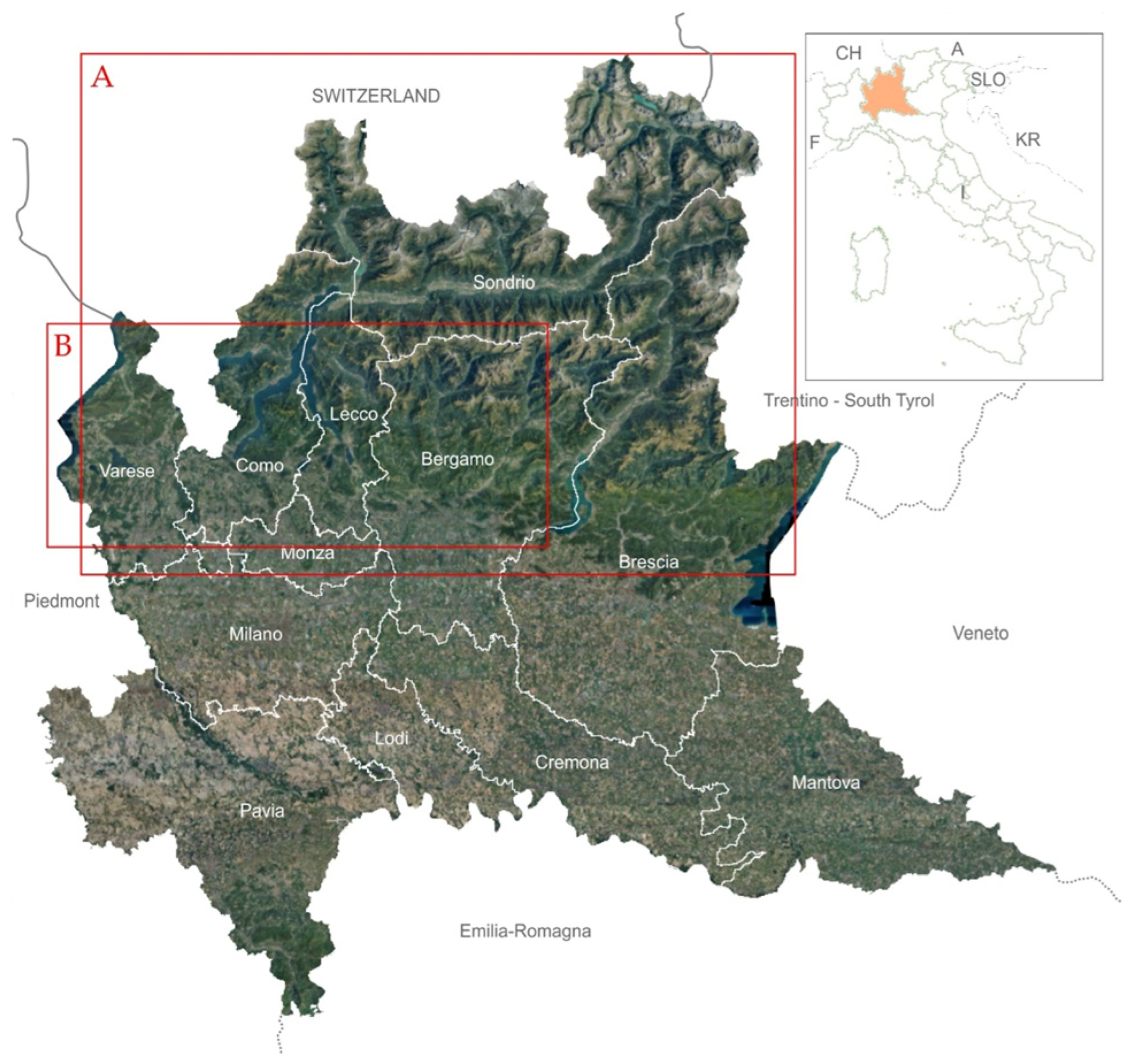
2.1. Study Area
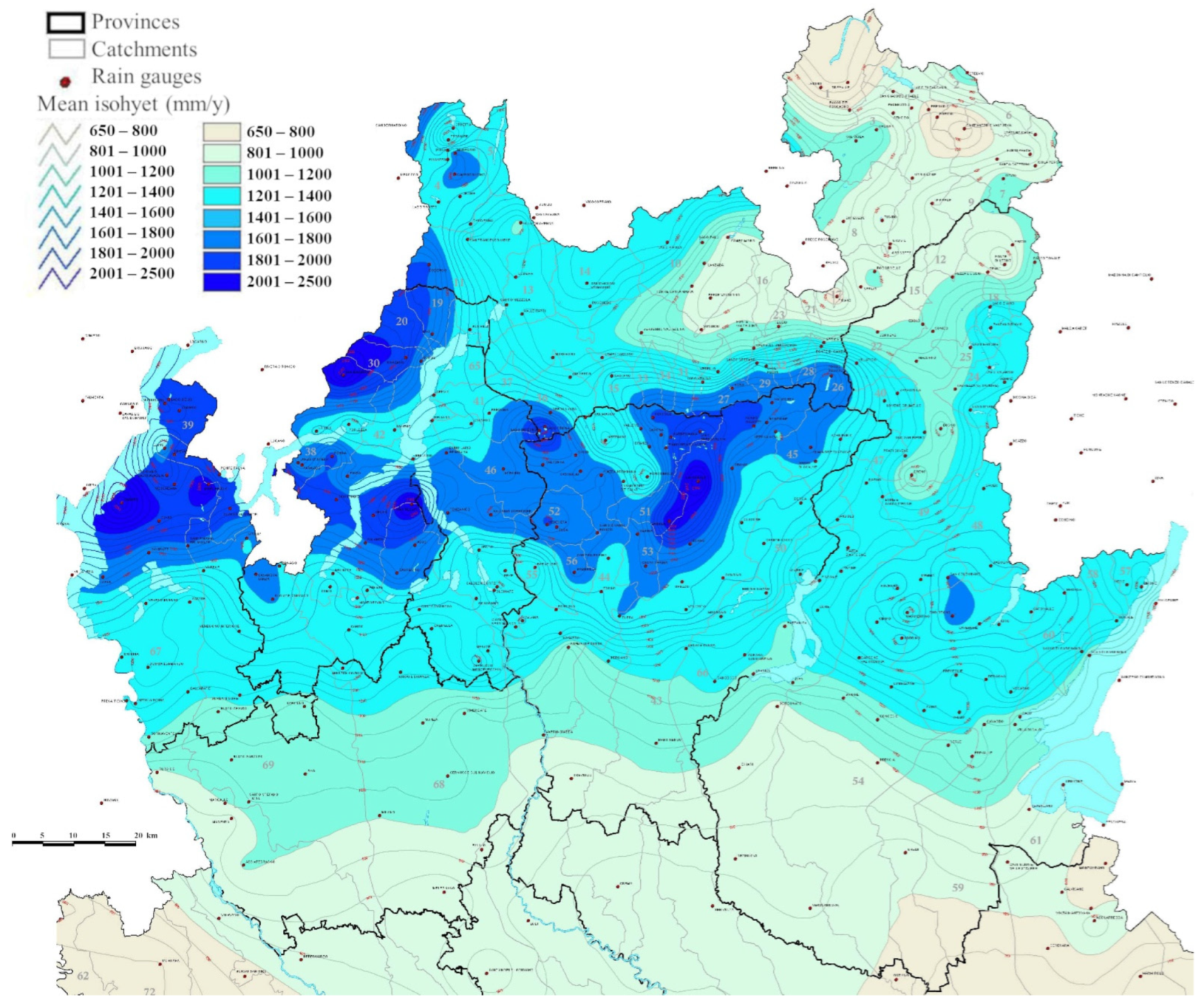
2.1.1. Climate
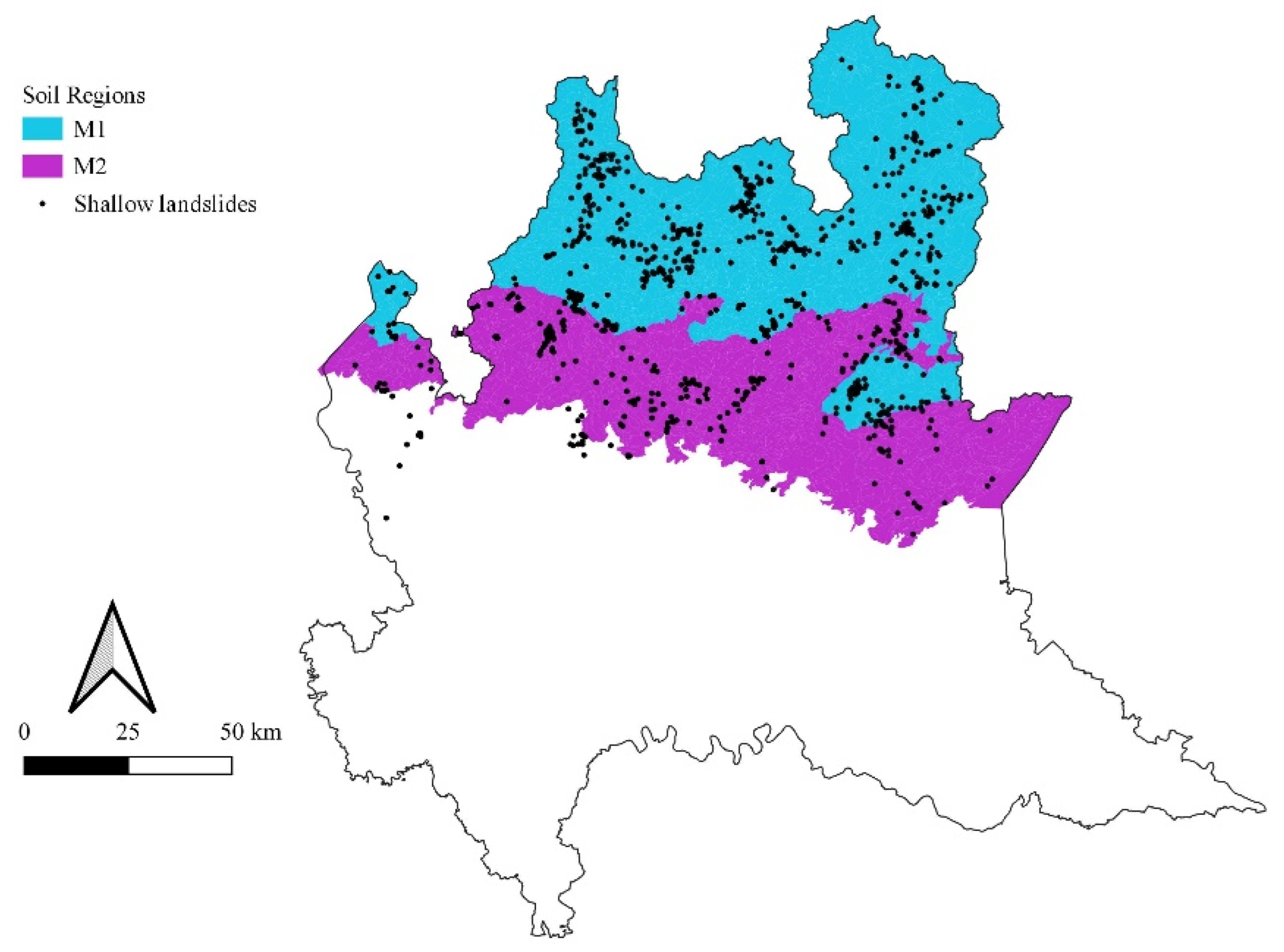
2.1.2. Geology and Soils
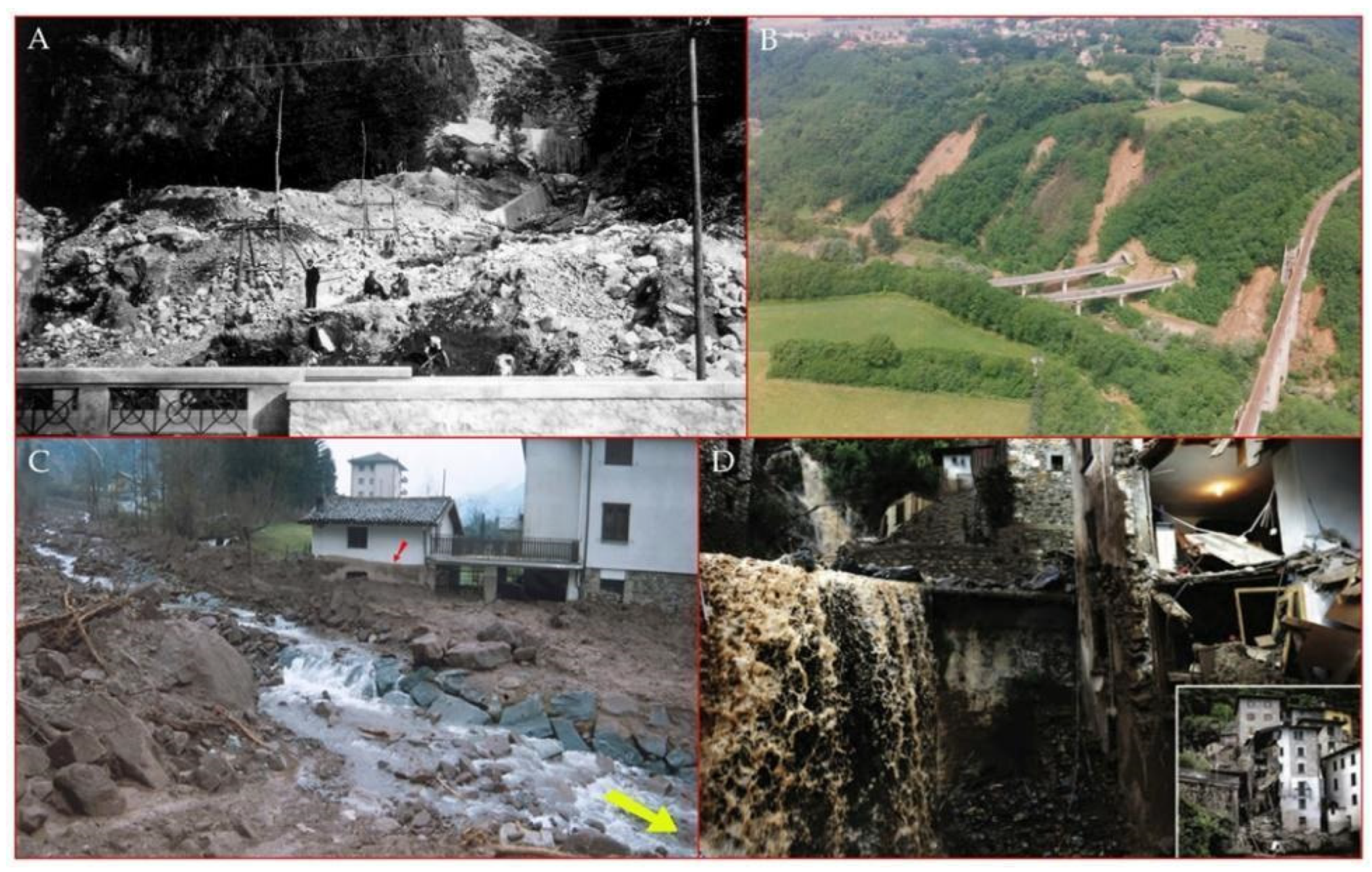
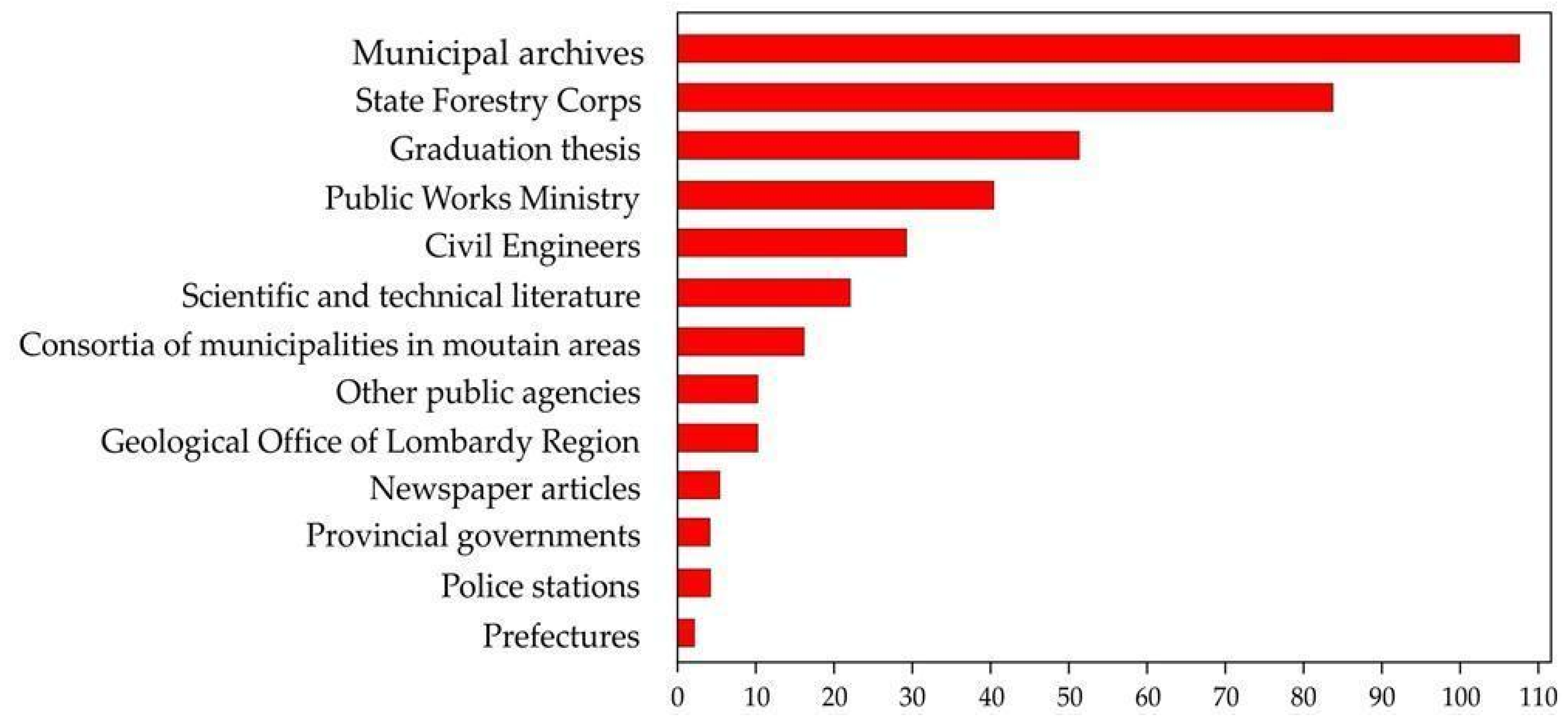
2.2. Landslides Data Collection
2.3. Rainfall Data Collection
2.4. Soil Data Collection
2.5. Database Creation
- (1)
- Landslide occurrence and type: date and season of occurrence, SS (soil slip) or MDF (mud and debris flow).
- (2)
- Location and topographical information: coordinates, municipality, province, catchment, elevation (min, max, and average), and slope (min, max, and average).
- (3)
- Land use.
- (4)
- Geological and pedological information: lithology, soil region, soil province, dominant STU, WRB classification; for the first meter of soil: stoniness, rockiness, depth, texture, skeleton, and organic carbon content.
- (5)
- Rainfall characteristics: MAP; triggering rainfall characteristics: cumulated precipitation, duration, and hourly intensity.
2.6. Statistical Analysis
2.7. Definition of Rainfall Thresholds
3. Results
3.1. Soil Properties and Landslide Occurrence
3.2. Relationships among Soil and Rainfall Characteristics for Events Triggering Landslides
3.3. Regional Thresholds
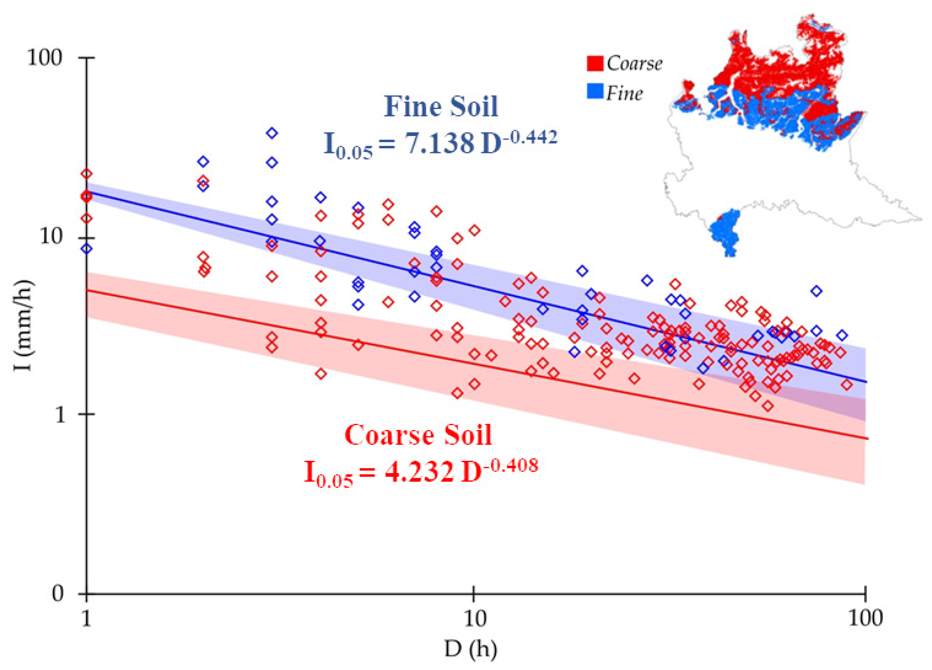
3.4. Soil-Based Rainfall Thresholds
3.4.1. Thresholds Defined by Soil Region
3.4.2. Threshold Defined by Soil Texture
3.4.3. Threshold Defined by Soil Groups
4. Discussion
5. Conclusions
- (i)
- The study showed that among the soil characteristics examined, which were the topographic and precipitation characteristics of triggered landslides, the one most correlated with the characteristics of rainfall events was soil depth. Rainfall events that triggered landslides lasted longer when the soil was deeper; in contrast, short, high-intensity events seemed more likely to trigger landslides in shallow soils. The organic carbon content and the percentage of rock fragments were not significantly correlated with the characteristics of landslide-triggering events.
- (ii)
- There were significant and positive correlations between the topographical characteristics (elevation and slope) and the stoniness and rockiness. The correlations between altitude and slope around the landslide sites and precipitation characteristics were not statistically significant. On the contrary, there were significant and positive correlations between topographical characteristics (in terms of slope and elevation) and stoniness and rockiness; in particular, where landslides were triggered along steeper slopes, the soils were shallower.
- (iii)
- The soil-based rainfall thresholds for the Alps and Prealps of Lombardy obtained by considering the soil regions were significantly different, with a lower threshold for landslide occurrence in the soil region M1, with soil developed over siliceous parent material, with respect to the whole study area and the soil region M2, which was characterized by soils developed over calcareous bedrock. The Skeletic Cambisols, the most widespread soils in the study area, showed the highest landslide density in both the M1 and M2 regions. Furthermore, considering textural classes (fine and coarse), the curves were also differentiated, with coarse soils being more susceptible to the triggering of landslides than fine soils.
- (iv)
- Considering both the texture and the main soil groups in the study area, given the same rainfall duration, the cumulative rainfall (and the rainfall intensity) needed to initiate a landslide increased in the following order: coarse and skeletal Cambisols < Umbrisols ≤ Podzols < fine Cambisols. The results of this study highlighted the primary role of pedological conditioning factors in differentiating the activation of rainfall-induced shallow landslides in a definite region.
- (v)
- The information on soils that is already available in regional and national databases could be used to define rainfall-pedological thresholds more accurately than empirical thresholds based solely on meteorological conditions, even when they are locally defined, and can be used to improve the ability of early warning systems to forecast the occurrence of shallow landslides and mud-debris flows.
Author Contributions
Funding
Institutional Review Board Statement
Informed Consent Statement
Data Availability Statement
Conflicts of Interest
References
- Bryant, E. Natural Hazards, 2nd ed.; Cambridge University Press: Cambridge, UK, 2005. [Google Scholar]
- European Environment Agency. Mapping the Impacts of Natural Hazards and Technological Accidents in Europe: An Overview of the Last Decade; Publications Office of the European Union: Luxembourg, 2011. [Google Scholar]
- Petley, D. Global Patterns of Loss of Life from Landslides. Geology 2012, 40, 927–930. [Google Scholar] [CrossRef]
- Froude, M.J.; Petley, D.N. Global Fatal Landslide Occurrence from 2004 to 2016. Nat. Hazards Earth Syst. Sci. 2018, 18, 2161–2181. [Google Scholar] [CrossRef] [Green Version]
- Haque, U.; da Silva, P.F.; Devoli, G.; Pilz, J.; Zhao, B.; Khaloua, A.; Wilopo, W.; Andersen, P.; Lu, P.; Lee, J.; et al. The Human Cost of Global Warming: Deadly Landslides and Their Triggers (1995–2014). Sci. Total Environ. 2019, 682, 673–684. [Google Scholar] [CrossRef]
- Mărgărint, M.C.; Niculiţă, M. Landslide Type and Pattern in Moldavian Plateau, NE Romania. In Landform Dynamics and Evolution in Romania; Radoane, M., Vespremeanu-Stroe, A., Eds.; Springer Geography; Springer International Publishing: Cham, Switzerland, 2017; pp. 271–304. [Google Scholar] [CrossRef]
- Popescu, M.E. Landslide Causal Factors and Landslide Remediatial Options. In Proceedings of the 3rd International Conference on Landslides, Slope Stability and Safety of Infra-Structures, Singapore, 11–12 July 2002; pp. 61–81. [Google Scholar]
- Lukić, T.; Bjelajac, D.; Fitzsimmons, K.E.; Marković, S.B.; Basarin, B.; Mlađan, D.; Micić, T.; Schaetzl, R.J.; Gavrilov, M.B.; Milanović, M.; et al. Factors Triggering Landslide Occurrence on the Zemun Loess Plateau, Belgrade Area, Serbia. Environ. Earth Sci. 2018, 77, 519. [Google Scholar] [CrossRef]
- Morar, C.; Lukić, T.; Basarin, B.; Valjarević, A.; Vujičić, M.; Niemets, L.; Telebienieva, I.; Boros, L.; Nagy, G. Shaping Sustainable Urban Environments by Addressing the Hydro-Meteorological Factors in Landslide Occurrence: Ciuperca Hill (Oradea, Romania). Int. J. Environ. Res. Public. Health 2021, 18, 5022. [Google Scholar] [CrossRef]
- Crosta, G.B.; Frattini, P. Distributed Modelling of Shallow Landslides Triggered by Intense Rainfall. Nat. Hazards Earth Syst. Sci. 2003, 3, 81–93. [Google Scholar] [CrossRef] [Green Version]
- Peruccacci, S.; Brunetti, M.T.; Luciani, S.; Vennari, C.; Guzzetti, F. Lithological and Seasonal Control on Rainfall Thresholds for the Possible Initiation of Landslides in Central Italy. Geomorphology 2012, 139–140, 79–90. [Google Scholar] [CrossRef]
- Tiranti, D.; Nicolò, G.; Gaeta, A.R. Shallow Landslides Predisposing and Triggering Factors in Developing a Regional Early Warning System. Landslides 2019, 16, 235–251. [Google Scholar] [CrossRef]
- Aleotti, P. A Warning System for Rainfall-Induced Shallow Failures. Eng. Geol. 2004, 73, 247–265. [Google Scholar] [CrossRef]
- Baum, R.L.; Godt, J.W. Erratum to: Early Warning of Rainfall-Induced Shallow Landslides and Debris Flows in the USA. Landslides 2010, 7, 387. [Google Scholar] [CrossRef] [Green Version]
- Papa, M.N.; Medina, V.; Ciervo, F.; Bateman, A. Derivation of Critical Rainfall Thresholds for Shallow Landslides as a Tool for Debris Flow Early Warning Systems. Hydrol. Earth Syst. Sci. 2013, 17, 4095–4107. [Google Scholar] [CrossRef] [Green Version]
- Piciullo, L.; Gariano, S.L.; Melillo, M.; Brunetti, M.T.; Peruccacci, S.; Guzzetti, F.; Calvello, M. Definition and Performance of a Threshold-Based Regional Early Warning Model for Rainfall-Induced Landslides. Landslides 2017, 14, 995–1008. [Google Scholar] [CrossRef]
- Segoni, S.; Rosi, A.; Rossi, G.; Catani, F.; Casagli, N. Analysing the Relationship between Rainfalls and Landslides to Define a Mosaic of Triggering Thresholds for Regional-Scale Warning Systems. Nat. Hazards Earth Syst. Sci. 2014, 14, 2637–2648. [Google Scholar] [CrossRef] [Green Version]
- Revellino, P.; Hungr, O.; Guadagno, F.M.; Evans, S.G. Velocity and Runout Simulation of Destructive Debris Flows and Debris Avalanches in Pyroclastic Deposits, Campania Region, Italy. Environ. Geol. 2004, 45, 295–311. [Google Scholar] [CrossRef]
- Huang, Y.; Sun, J.; Zhu, C. Mechanism and Prevention of Debris Flow Disaster. Water 2022, 14, 1143. [Google Scholar] [CrossRef]
- He, S.; Liu, W.; Li, X. Prediction of Impact Force of Debris Flows Based on Distribution and Size of Particles. Environ. Earth Sci. 2016, 75, 298. [Google Scholar] [CrossRef]
- House, P.K. Using Geology to Improve Flood Hazard Management on Alluvial Fans—An Example From Laughlin, Nevada. J. Am. Water Resour. Assoc. 2005, 41, 1431–1447. [Google Scholar] [CrossRef]
- Chang, T.-C.; Wang, Z.-Y.; Chien, Y.-H. Hazard Assessment Model for Debris Flow Prediction. Environ. Earth Sci. 2010, 60, 1619–1630. [Google Scholar] [CrossRef]
- Quan Luna, B.; Blahut, J.; Camera, C.; van Westen, C.; Apuani, T.; Jetten, V.; Sterlacchini, S. Physically Based Dynamic Run-out Modelling for Quantitative Debris Flow Risk Assessment: A Case Study in Tresenda, Northern Italy. Environ. Earth Sci. 2014, 72, 645–661. [Google Scholar] [CrossRef]
- Turconi, L.; De, S.K.; Demurtas, F.; Demurtas, L.; Pendugiu, B.; Tropeano, D.; Savio, G. An Analysis of Debris-Flow Events in the Sardinia Island (Thyrrenian Sea, Italy). Environ. Earth Sci. 2013, 69, 1509–1521. [Google Scholar] [CrossRef]
- Luino, F. Sequence of Instability Processes Triggered by Heavy Rainfall in the Northern Italy. Geomorphology 2005, 66, 13–39. [Google Scholar] [CrossRef]
- Guzzetti, F.; Peruccacci, S.; Rossi, M.; Stark, C.P. The Rainfall Intensity–Duration Control of Shallow Landslides and Debris Flows: An Update. Landslides 2008, 5, 3–17. [Google Scholar] [CrossRef]
- Segoni, S.; Piciullo, L.; Gariano, S.L. A Review of the Recent Literature on Rainfall Thresholds for Landslide Occurrence. Landslides 2018, 15, 1483–1501. [Google Scholar] [CrossRef]
- Guzzetti, F. Landslide Fatalities and the Evaluation of Landslide Risk in Italy. Eng. Geol. 2000, 58, 89–107. [Google Scholar] [CrossRef]
- Salvati, P.; Bianchi, C.; Rossi, M.; Guzzetti, F. Societal Landslide and Flood Risk in Italy. Nat. Hazards Earth Syst. Sci. 2010, 10, 465–483. [Google Scholar] [CrossRef]
- Salvati, P.; Bianchi, C. Rapporto Sul Rischio Posto Alla Popolazione Italiana da Frane e Inondazioni. Quinquennio 2014–2018; CNR-IRPI: Perugia, Italy, 2019. Available online: https://polaris.irpi.cnr.it/report/ (accessed on 10 February 2022).
- Govi, M.; Mortara, G.; Sorzana, P.F. Eventi Idrologici e Frane. Geol. Appl. Idrogeol. 1985, 18, 359–375. [Google Scholar]
- Govi, M.; Turitto, O. Ricerche Bibliografiche per Un Catalogo Sulle Inondazioni, Piene Torrentizie, Frane in Valtellina e Valchiavenna; Quaderni di Studi e di Documentazione. Associazione Mineraria Subalpina, 1994. Available online: https://geomorphology.irpi.cnr.it (accessed on 10 February 2022).
- Tropeano, D.; Govi, M.; Mortara, G.; Turitto, O.; Sorzana, P.F.; Negrini, G.; Arattano, M. Eventi Alluvionali e Frane in Italia Settentrionale Nel Periodo 1975–1981; L’Artistica Savigliano: Torino, Italy, 1999. [Google Scholar]
- Tropeano, D.; Luino, F.; Turconi, L. Eventi di Piena e Frana in Italia Settentrionale nel Periodo 2002–2004; SMS: Bussoleno, Italy, 2006. [Google Scholar]
- Turconi, L.; Luino, F. Eventi di Piena e Frana in Italia Settentrionale nel Periodo 2005–2016; SMS: Moncalieri, Italy, 2017. [Google Scholar]
- Moser, M.; Hohensinn, F. Geotechnical Aspects of Soil Slips in Alpine Regions. Eng. Geol. 1983, 19, 185–211. [Google Scholar] [CrossRef]
- Meusburger, K.; Alewell, C. Impacts of Anthropogenic and Environmental Factors on the Occurrence of Shallow Landslides in an Alpine Catchment (Urseren Valley, Switzerland). Nat. Hazards Earth Syst. Sci. 2008, 8, 509–520. [Google Scholar] [CrossRef] [Green Version]
- Norbiato, D.; Borga, M.; Merz, R.; Blöschl, G.; Carton, A. Controls on Event Runoff Coefficients in the Eastern Italian Alps. J. Hydrol. 2009, 375, 312–325. [Google Scholar] [CrossRef]
- Stanchi, S.; Freppaz, M.; Zanini, E. The Influence of Alpine Soil Properties on Shallow Movement Hazards, Investigated through Factor Analysis. Nat. Hazards Earth Syst. Sci. 2012, 12, 1845–1854. [Google Scholar] [CrossRef] [Green Version]
- Stanchi, S.; Freppaz, M.; Oberto, E.; Caimi, A.; Zanini, E. Plastic and Liquid Limits in Alpine Soils: Methods of Measurement and Relations with Soil Properties. Adv. Geoecol. 2008, 39, 594–604. [Google Scholar]
- Peruccacci, S.; Brunetti, M.T.; Gariano, S.L.; Melillo, M.; Rossi, M.; Guzzetti, F. Rainfall Thresholds for Possible Landslide Occurrence in Italy. Geomorphology 2017, 290, 39–57. [Google Scholar] [CrossRef]
- Palladino, M.R.; Viero, A.; Turconi, L.; Brunetti, M.T.; Peruccacci, S.; Melillo, M.; Luino, F.; Deganutti, A.M.; Guzzetti, F. Rainfall Thresholds for the Activation of Shallow Landslides in the Italian Alps: The Role of Environmental Conditioning Factors. Geomorphology 2018, 303, 53–67. [Google Scholar] [CrossRef]
- Roccati, A.; Faccini, F.; Luino, F.; Ciampalini, A.; Turconi, L. Heavy Rainfall Triggering Shallow Landslides: A Susceptibility Assessment by a GIS-Approach in a Ligurian Apennine Catchment (Italy). Water 2019, 11, 605. [Google Scholar] [CrossRef] [Green Version]
- Guzzetti, F.; Peruccacci, S.; Rossi, M.; Stark, C.P. Rainfall Thresholds for the Initiation of Landslides in Central and Southern Europe. Meteorol. Atmos. Phys. 2007, 98, 239–267. [Google Scholar] [CrossRef]
- Zêzere, J.L. Landslide Susceptibility Assessment Considering Landslide Typology. A Case Study in the Area North of Lisbon (Portugal). Nat. Hazards Earth Syst. Sci. 2002, 2, 73–82. [Google Scholar] [CrossRef]
- Abraham, M.T.; Pothuraju, D.; Satyam, N. Rainfall Thresholds for Prediction of Landslides in Idukki, India: An Empirical Approach. Water 2019, 11, 2113. [Google Scholar] [CrossRef] [Green Version]
- Jordanova, G.; Gariano, S.L.; Melillo, M.; Peruccacci, S.; Brunetti, M.T.; Jemec Auflič, M. Determination of Empirical Rainfall Thresholds for Shallow Landslides in Slovenia Using an Automatic Tool. Water 2020, 12, 1449. [Google Scholar] [CrossRef]
- Caine, N. The Rainfall Intensity: Duration Control of Shallow Landslides and Debris Flows. Geogr. Ann. Ser. Phys. Geogr. 1980, 62, 23. [Google Scholar] [CrossRef]
- Wieczorek, G.F. Effect of Rainfall Intensity and Duration on Debris Flows in Central Santa Cruz Mountains, California. In Reviews in Engineering Geology; Geological Society of America: Boulder, CO, USA, 1987; Volume 7, pp. 93–104. [Google Scholar] [CrossRef]
- Crosta, G. Regionalization of Rainfall Thresholds: An Aid to Landslide Hazard Evaluation. Environ. Geol. 1998, 35, 131–145. [Google Scholar] [CrossRef]
- Saito, H.; Nakayama, D.; Matsuyama, H. Relationship between the Initiation of a Shallow Landslide and Rainfall Intensity—Duration Thresholds in Japan. Geomorphology 2010, 118, 167–175. [Google Scholar] [CrossRef]
- Hong, M.; Kim, J.; Jeong, S. Rainfall Intensity-Duration Thresholds for Landslide Prediction in South Korea by Considering the Effects of Antecedent Rainfall. Landslides 2018, 15, 523–534. [Google Scholar] [CrossRef]
- Roccati, A.; Faccini, F.; Luino, F.; Turconi, L.; Guzzetti, F. Rainfall Events with Shallow Landslides in the Entella Catchment, Liguria, Northern Italy. Nat. Hazards Earth Syst. Sci. 2018, 18, 2367–2386. [Google Scholar] [CrossRef] [Green Version]
- Schultz, A.P.; Jibson, R.W. (Eds.) Landslide Processes of the Eastern United States and Puerto Rico; Special paper; Geological Society of America: Boulder, CO, USA, 1989. [Google Scholar]
- Crosta, G.B.; Frattini, P. Rainfall Thresholds for Triggering Soil Slips and Debris Flow. In Proceedings of the 2nd EGS Plinius Conference on Mediterranean Storms, Siena, Italy, 16–18 October 2001; pp. 463–487. [Google Scholar]
- Floris, M.; Mari, M.; Romeo, R.W.; Gori, U. Modelling of Landslide-Triggering Factors—A Case Study in the Northern Apennines, Italy. In Engineering Geology for Infrastructure Planning in Europe; Hack, R., Azzam, R., Charlier, R., Eds.; Lecture Notes in Earth Sciences; Springer: Berlin/Heidelberg, Germany, 2004; Volume 104, pp. 745–753. [Google Scholar] [CrossRef]
- Brunetti, M.T.; Peruccacci, S.; Rossi, M.; Luciani, S.; Valigi, D.; Guzzetti, F. Rainfall Thresholds for the Possible Occurrence of Landslides in Italy. Nat. Hazards Earth Syst. Sci. 2010, 10, 447–458. [Google Scholar] [CrossRef]
- Rosi, A.; Peternel, T.; Jemec-Auflič, M.; Komac, M.; Segoni, S.; Casagli, N. Rainfall Thresholds for Rainfall-Induced Landslides in Slovenia. Landslides 2016, 13, 1571–1577. [Google Scholar] [CrossRef]
- Crozier, M.J. Prediction of Rainfall-Triggered Landslides: A Test of the Antecedent Water Status Model. Earth Surf. Process. Landf. 1999, 24, 825–833. [Google Scholar] [CrossRef]
- Glade, T.; Crozier, M.; Smith, P. Applying Probability Determination to Refine Landslide-Triggering Rainfall Thresholds Using an Empirical “Antecedent Daily Rainfall Model”. Pure Appl. Geophys. 2000, 157, 1059–1079. [Google Scholar] [CrossRef]
- Godt, J.W.; Baum, R.L.; Lu, N. Landsliding in Partially Saturated Materials: Landslide Forecasting. Geophys. Res. Lett. 2009, 36, L02403. [Google Scholar] [CrossRef]
- Bogaard, T.; Greco, R. Invited Perspectives: Hydrological Perspectives on Precipitation Intensity-Duration Thresholds for Landslide Initiation: Proposing Hydro-Meteorological Thresholds. Nat. Hazards Earth Syst. Sci. 2018, 18, 31–39. [Google Scholar] [CrossRef] [Green Version]
- Valenzuela, P.; Domínguez-Cuesta, M.J.; Mora García, M.A.; Jiménez-Sánchez, M. Rainfall Thresholds for the Triggering of Landslides Considering Previous Soil Moisture Conditions (Asturias, NW Spain). Landslides 2018, 15, 273–282. [Google Scholar] [CrossRef]
- Zhao, B.; Dai, Q.; Han, D.; Dai, H.; Mao, J.; Zhuo, L. Probabilistic Thresholds for Landslides Warning by Integrating Soil Moisture Conditions with Rainfall Thresholds. J. Hydrol. 2019, 574, 276–287. [Google Scholar] [CrossRef]
- Bogaard, T.A.; van Asch, T.W.J. The Role of the Soil Moisture Balance in the Unsaturated Zone on Movement and Stability of the Beline Landslide, France. Earth Surf. Process. Landf. 2002, 27, 1177–1188. [Google Scholar] [CrossRef]
- Salciarini, D.; Godt, J.W.; Savage, W.Z.; Conversini, P.; Baum, R.L.; Michael, J.A. Modeling Regional Initiation of Rainfall-Induced Shallow Landslides in the Eastern Umbria Region of Central Italy. Landslides 2006, 3, 181–194. [Google Scholar] [CrossRef]
- Zung, A.B.; Sorenson, C.J.; Winthers, E. Landslide Soils and Geomorphology in Bridger-Teton National Forest, Northwest Wyoming. Phys. Geogr. 2009, 30, 501–516. [Google Scholar] [CrossRef]
- Li, G.; Lei, Y.; Yao, H.; Wu, S.; Ge, J. The Influence of Land Urbanization on Landslides: An Empirical Estimation Based on Chinese Provincial Panel Data. Sci. Total Environ. 2017, 595, 681–690. [Google Scholar] [CrossRef]
- Persichillo, M.G.; Bordoni, M.; Meisina, C. The Role of Land Use Changes in the Distribution of Shallow Landslides. Sci. Total Environ. 2017, 574, 924–937. [Google Scholar] [CrossRef]
- Tofani, V.; Bicocchi, G.; Rossi, G.; Segoni, S.; D’Ambrosio, M.; Casagli, N.; Catani, F. Soil Characterization for Shallow Landslides Modeling: A Case Study in the Northern Apennines (Central Italy). Landslides 2017, 14, 755–770. [Google Scholar] [CrossRef] [Green Version]
- Montgomery, D.R.; Dietrich, W.E. A Physically Based Model for the Topographic Control on Shallow Landsliding. Water Resour. Res. 1994, 30, 1153–1171. [Google Scholar] [CrossRef]
- Iverson, R.M. Landslide Triggering by Rain Infiltration. Water Resour. Res. 2000, 36, 1897–1910. [Google Scholar] [CrossRef] [Green Version]
- Tsaparas, I.; Rahardjo, H.; Toll, D.G.; Leong, E.C. Controlling Parameters for Rainfall-Induced Landslides. Comput. Geotech. 2002, 29, 1–27. [Google Scholar] [CrossRef]
- Rosso, R.; Rulli, M.C.; Vannucchi, G. A Physically Based Model for the Hydrologic Control on Shallow Landsliding: Hydrologic control on shallow landsliding. Water Resour. Res. 2006, 42, W06410. [Google Scholar] [CrossRef]
- Tsai, T.-L.; Yang, J.-C. Modeling of Rainfall-Triggered Shallow Landslide. Environ. Geol. 2006, 50, 525–534. [Google Scholar] [CrossRef]
- Anagnostopoulos, G.G.; Fatichi, S.; Burlando, P. An Advanced Process-Based Distributed Model for the Investigation of Rainfall-Induced Landslides: The Effect of Process Representation and Boundary Conditions: Modeling rainfall-induced landslides. Water Resour. Res. 2015, 51, 7501–7523. [Google Scholar] [CrossRef]
- Schilirò, L.; Montrasio, L.; Scarascia Mugnozza, G. Prediction of Shallow Landslide Occurrence: Validation of a Physically-Based Approach through a Real Case Study. Sci. Total Environ. 2016, 569–570, 134–144. [Google Scholar] [CrossRef]
- Chiu, Y.-Y.; Chen, H.-E.; Yeh, K.-C. Investigation of the Influence of Rainfall Runoff on Shallow Landslides in Unsaturated Soil Using a Mathematical Model. Water 2019, 11, 1178. [Google Scholar] [CrossRef] [Green Version]
- Fan, L.; Lehmann, P.; Or, D. Effects of Soil Spatial Variability at the Hillslope and Catchment Scales on Characteristics of Rainfall-Induced Landslides: Soil spatial variability and rainfall-induced landslides. Water Resour. Res. 2016, 52, 1781–1799. [Google Scholar] [CrossRef] [Green Version]
- Govi, M.; Sorzana, P.F. Landslide Susceptibility as a Function of Critical Rainfall Amount in Piedmont Basin (Northwestern Italy). Stud. Geomorphol. Carpatho-Balc. 1980, 14, 43–61. [Google Scholar]
- Luino, F.; De Graff, J.; Roccati, A.; Biddoccu, M.; Cirio, C.G.; Faccini, F.; Turconi, L. Eighty Years of Data Collected for the Determination of Rainfall Threshold Triggering Shallow Landslides and Mud-Debris Flows in the Alps. Water 2019, 12, 133. [Google Scholar] [CrossRef] [Green Version]
- Simoni, S.; Zanotti, F.; Bertoldi, G.; Rigon, R. Modelling the Probability of Occurrence of Shallow Landslides and Channelized Debris Flows Using GEOtop-FS. Hydrol. Process. 2008, 22, 532–545. [Google Scholar] [CrossRef]
- Marazzi, S. Atlante Orografico Delle Alpi: SOIUSA, Suddivisione Orografica Internazionale Unificata Del Sistema Alpino. 2005. Available online: webgis.arpa.piemonte.it (accessed on 13 December 2021).
- Ceriani, M.; Carelli, M. Carta Delle Precipitazioni Medie, Minime e Massime Annue Del Territorio Alpino Lombardi (Registrate Nel Periodo 1891–1990). 1992. Available online: http://www.centrometeolombardo.com/ (accessed on 13 December 2021).
- Marra, F.; Nikolopoulos, E.I.; Creutin, J.D.; Borga, M. Space–Time Organization of Debris Flows-Triggering Rainfall and Its Effect on the Identification of the Rainfall Threshold Relationship. J. Hydrol. 2016, 541, 246–255. [Google Scholar] [CrossRef]
- Fratianni, S.; Acquaotta, F. The Climate of Italy. In Landscapes and Landforms of Italy; Soldati, M., Marchetti, M., Eds.; World Geomorphological Landscapes; Springer International Publishing: Cham, Switzerland, 2017; pp. 29–38. [Google Scholar] [CrossRef]
- Costantini, E.A.C.; L’Abate, G.; Barbetti, R.; Fantappié, M.; Lorenzetti, R.; Magini, S. Carta dei suoli d’Italia-Soil Map of Italy at 1:1,000,000 Scale. 2012, Consiglio per Ricerca e la Sperimentazione in Agricoltura, Ministero delle Politiche Agricole Alimentari e Forestali. Available online: https://esdac.jrc.ec.europa.eu/content/carta-dei-suoli-ditalia-soil-map-italy (accessed on 13 December 2021).
- IUSS Working Group WRB. Ld Reference Base for Soil Resources 2014, Update 2015: International Soil Classification System for Naming Soils and Creating Legends for Soil Maps; World Soil Resources Report No. 106; Food and Agriculture Organization: Rome, Italy, 2015; 192p. [Google Scholar]
- Brunetti, M.T.; Peruccacci, S.; Antronico, L.; Bartolini, D.; Deganutti, A.M.; Gariano, S.L.; Iovine, G.; Luciani, S.; Luino, F.; Melillo, M.; et al. Catalogue of Rainfall Events with Shallow Landslides and New Rainfall Thresholds in Italy. In Engineering Geology for Society and Territory; Lollino, G., Giordan, D., Crosta, G.B., Corominas, J., Azzam, R., Wasowski, J., Sciarra, N., Eds.; Springer International Publishing: Cham, Switzerland, 2015; Volume 2, pp. 1575–1579. [Google Scholar] [CrossRef]
- Brenna, S.; D’Alessio, M.; Rasio, R. Carta Dei Pedopaesaggi Della Lombardia—Pedo-Landscape Map of Lombardy. (Scale 1:250,000); Regione Lombardia; Agricoltura, Ente Regionale di Sviluppo Agricolo della Lombardia: Milano, Italy, 2001. [Google Scholar]
- ERSAF. Basi Informative Dei Suoli. 2013. Available online: https://www.ersaf.lombardia.it/it (accessed on 15 September 2020).
- ERSAF. I Suoli Della Lombardia. 2021. Available online: https://www.ersaf.lombardia.it/it (accessed on 15 September 2020).
- Ledl, T. Kernel Density Estimation: Theory and Application in Discriminant Analysis. Austrian J. Stat. 2016, 33, 267–279. [Google Scholar] [CrossRef]
- Silverman, B.W. Density Estimation for Statistics and Data Analysis, 1st ed.; Routledge: London, UK, 2018. [Google Scholar] [CrossRef]
- Sheather, S.J. Density Estimation. Stat. Sci. 2004, 19, 588–597. [Google Scholar] [CrossRef]
- Ceriani, M.; Lauzi, S.; Padovan, N. Rainfall Thresholds Triggering Debris Flows in the Alpine Area of Lombardia Region, Central Alps–Italy. In Proceedings of the Man and Mountain’94. First International Congress for the Protection and Development of Mountain Environment, Ponte di Legno, Italy, 20–24 June 1994; pp. 123–139. [Google Scholar]
- Cancelli, A.; Nova, R. Landslide in Soil Debris Cover Triggered by Rainstorm in Valtellina. In Proceedings of the IV International Conference and Field Workshop on Landslides, Tokyo, Japan, 23–31 August 1985; pp. 267–272. [Google Scholar]
- European Commission-European Soil Bureau Network. Soil Atlas of Europe. 2005. Available online: https://esdac.jrc.ec.europa.eu/content/soil-atlas-europe (accessed on 15 September 2020).
- Gautam, P.; Kubota, T.; Sapkota, L.M.; Shinohara, Y. Landslide Susceptibility Mapping with GIS in High Mountain Area of Nepal: A Comparison of Four Methods. Environ. Earth Sci. 2021, 80, 359. [Google Scholar] [CrossRef]
- Dapporto, S.; Aleotti, P.; Casagli, N.; Polloni, G. Analysis of Shallow Failures Triggered by the 14–16 November 2002 Event in the Albaredo Valley, Valtellina (Northern Italy). Adv. Geosci. 2005, 2, 305–308. [Google Scholar] [CrossRef] [Green Version]
- Johnson, K.A.; Sitar, N. Hydrologic Conditions Leading to Debris-Flow Initiation. Can. Geotech. J. 1990, 27, 789–801. [Google Scholar] [CrossRef]
- Fredlund, D.G.; Xing, A.; Fredlund, M.D.; Barbour, S.L. The Relationship of the Unsaturated Soil Shear Strength to the Soil-Water Characteristic Curve. Can. Geotech. J. 1996, 33, 440–448. [Google Scholar] [CrossRef]
- Jotisankasa, A.; Vathananukij, H. Investigation of Soil Moisture Characteristics of Landslide-Prone Slopes in Thailand. In Proceedings of the International Conference on Management of Landslide Hazard in the Asia-Pacific Region, Sendai, Japan, 11–15 November 2008; p. 12. [Google Scholar]
- Bordoni, M.; Inzaghi, F.; Vivaldi, V.; Valentino, R.; Bittelli, M.; Meisina, C. A Data-Driven Method for the Temporal Estimation of Soil Water Potential and Its Application for Shallow Landslides Prediction. Water 2021, 13, 1208. [Google Scholar] [CrossRef]
- Andrewwinner, R.; Chandrasekaran, S.S. Investigation on the Failure Mechanism of Rainfall-Induced Long-Runout Landslide at Upputhode, Kerala State of India. Land 2021, 10, 1212. [Google Scholar] [CrossRef]
- Moradi, S.; Heinze, T.; Budler, J.; Gunatilake, T.; Kemna, A.; Huisman, J.A. Combining Site Characterization, Monitoring and Hydromechanical Modeling for Assessing Slope Stability. Land 2021, 10, 423. [Google Scholar] [CrossRef]
- Fusco, F.; Mirus, B.; Baum, R.; Calcaterra, D.; De Vita, P. Incorporating the Effects of Complex Soil Layering and Thickness Local Variability into Distributed Landslide Susceptibility Assessments. Water 2021, 13, 713. [Google Scholar] [CrossRef]
- Sajinkumar, K.S.; Rinu, S.; Oommen, T.; Vishnu, C.L.; Praveen, K.R.; Rani, V.R.; Muraleedharan, C. Improved Rainfall Threshold for Landslides in Data Sparse and Diverse Geomorphic Milieu: A Cluster Analysis Based Approach. Nat. Hazards 2020, 103, 639–657. [Google Scholar] [CrossRef]
- Marino, P.; Peres, D.J.; Cancelliere, A.; Greco, R.; Bogaard, T.A. Soil Moisture Information Can Improve Shallow Landslide Forecasting Using the Hydrometeorological Threshold Approach. Landslides 2020, 17, 2041–2054. [Google Scholar] [CrossRef]


| Soil Region | STU ID | Area km2 | % Area/Region | Dominant Soils | Average Depth, cm | Textural Class | N° of Landslides | Landslide Density (N/km2) |
|---|---|---|---|---|---|---|---|---|
| M1 | 1 | 1365 | 34% | Skeletic Cambisol | 150 | SL | 309 | 0.23 |
| M1 | 12 | 932 | 23% | Umbric and Skeletic Podzol | 150 | SL | 65 | 0.07 |
| M1 | 15 | 766 | 19% | Humic Umbrisol | 90 | SL (LS) | 99 | 0.13 |
| M1 | 8 | 456 | 11% | Humic and Skeletic Leptosol | 30 | SL (L) | 13 | 0.03 |
| M1 | 14 | 225 | 6% | Cambic and Leptic Regosol | 60 | SL-LS | 34 | 0.15 |
| M1 | 2 | 160 | 4% | Skeletic Cambisol | 200 | SL (LS) | 54 | 0.34 |
| M1 | 6 | 111 | 3% | Eutric Fluvisol | 120 | SL | - | - |
| M1 | 0 | 17 | 0% | Skeletic Fluvisol and Leptic Regosol | 25 | SL-LS | - | - |
| M2 | 4 | 1491 | 39% | Leptic and Eutric Cambisol | 100 | CL e L | 114 | 0.08 |
| M2 | 9 | 858 | 22% | Skeletic and Rendzic Leptosol | 20 | L-SL (SiL) | 45 | 0.05 |
| M2 | 2 | 570 | 15% | Leptic and Skeletic Cambisol | 170 | L (CL) | 85 | 0.15 |
| M2 | 3 | 274 | 7% | Leptic and Fluvic Cambisol | 70 | CL | 15 | 0.05 |
| M2 | 10 | 231 | 6% | Luvisol | 180 | CL (SCL) | 33 | 0.14 |
| M2 | 11 | 130 | 3% | Leptic Phaeozem | 60 | L (SL) | 8 | 0.06 |
| M2 | 15 | 124 | 3% | Umbrisol | 90 | SL (SiL) | 11 | 0.09 |
| M2 | 13 | 94 | 2% | Calcaric and Leptic Regosol | 60 | L (CL) | 5 | 0.05 |
| M2 | 8 | 57 | 1% | Skeletic Leptosol | 40 | SL | 1 | 0.02 |
| M2 | 6 | 21 | 1% | Haplic Fluvisol | 150 | SL | - | - |
| Num | Mean | St. Dev | Min | Median | Max | |
|---|---|---|---|---|---|---|
| Surface Stoniness (%) | 10,987 | 12.19 | 13.53 | 0.00 | 6.00 | 80.00 |
| M1 | 5621 | 14.86 a | 12.54 | 0.00 | 16.00 | 35.00 |
| M2 | 4868 | 10.10 b | 14.44 | 0.00 | 1.00 | 80.00 |
| Surface Rockiness (%) | 10,987 | 10.36 | 9.00 | 0.00 | 10.00 | 65.00 |
| M1 | 5621 | 12.55 a | 9.34 | 0.00 | 12.00 | 65.00 |
| M2 | 4868 | 8.89 b | 7.97 | 0.00 | 5.00 | 32.00 |
| Depth (cm) | 10,987 | 93.02 | 71.86 | 8.00 | 73.00 | 294.00 |
| M1 | 5621 | 86.57 a | 61.78 | 8.00 | 73.00 | 204.00 |
| M2 | 4868 | 96.91 b | 80.36 | 11.00 | 55.00 | 294.00 |
| Skeleton, up to 1 m depth (%) | 10,987 | 30.81 | 16.70 | 0.00 | 32.00 | 80.00 |
| M1 | 5621 | 35.98 a | 10.61 | 3.00 | 35.00 | 69.00 |
| M2 | 4868 | 27.15 b | 19.75 | 4.00 | 21.00 | 80.00 |
| Organic C, up to 1 m depth (%) | 10,987 | 2.99 | 2.17 | 0.70 | 2.20 | 11.10 |
| M1 | 5621 | 3.56 a | 2.11 | 0.80 | 2.40 | 8.50 |
| M2 | 4868 | 2.29 b | 1.66 | 0.70 | 1.90 | 9.50 |
| Elevation *, average (m a.s.l.) | 872 | 912.7 | 484.4 | 211.6 | 822.6 | 2453.3 |
| M1 | 564 | 1044.1 a | 456.4 | 242.1 | 981.2 | 2453.3 |
| M2 | 318 | 683.8 b | 324.2 | 211.6 | 642.7 | 2012.5 |
| Slope *, average (%) | 872 | 58.30 | 23.77 | 3.72 | 56.46 | 141.47 |
| M1 | 554 | 62.12 a | 20.83 | 3.72 | 61.02 | 141.47 |
| M2 | 318 | 51.63 b | 22.77 | 4.86 | 49.79 | 141.00 |
| Mean | Number of Events | Std. Dev. | Minimum | Median | Maximum | |
|---|---|---|---|---|---|---|
| Cumulative Precipitation, mm | ||||||
| Soil region M1 | 95.6 a | 246 | 72.7 | 6.3 | 80.8 | 382.0 |
| Soil region M2 | 107.9 a | 111 | 79.8 | 2.0 | 79.5 | 382.0 |
| All events | 99.4 | 357 | 75.1 | 2.0 | 80.0 | 382.0 |
| Duration, h | ||||||
| Soil region M1 | 33.5 a | 246 | 27.1 | 1.0 | 32.0 | 110.0 |
| Soil region M2 | 27.1 b | 111 | 26.1 | 1.0 | 19.0 | 106.0 |
| All events | 31.4 | 357 | 26.0 | 1.0 | 28.0 | 110.0 |
| Intensity, mm/h | ||||||
| Soil region M1 | 4.6 a | 246 | 4.7 | 0.3 | 2.9 | 31.8 |
| Soil region M2 | 8.2 b | 111 | 9.4 | 1.0 | 4.5 | 39.0 |
| All events | 5.7 | 357 | 6.7 | 0.3 | 3.1 | 39.0 |
| Ston. | Rock. | Depth | Skel. | C org. | D | Pc | I | EL | SLP | |
|---|---|---|---|---|---|---|---|---|---|---|
| Ston. | 1 | 0.11 | 0.10 | 0.18 | 0.12 | 0.04 | −0.04 | −0.16 | 0.25 | 0.12 |
| Rock. | 1 | −0.53 | 0.21 | 0.49 | 0.01 | −0.02 | −0.07 | 0.12 | 0.22 | |
| Depth | 1 | −0.14 | −0.46 | 0.16 | 0.04 | −0.23 | −0.07 | −0.18 | ||
| Skel. | 1 | 0.17 | 0.01 | −0.07 | −0.02 | 0.33 | 0.10 | |||
| C org. | 1 | −0.09 | −0.10 | −0.02 | 0.28 | 0.02 | ||||
| D | 1 | 0.78 | −0.47 | −0.05 | −0.01 | |||||
| Pc | 1 | −0.12 | −0.11 | 0.02 | ||||||
| I | 1 | −0.03 | −0.01 | |||||||
| EL | 1 | 0.13 | ||||||||
| SLP | 1 |
| Events | Intercept, α | Slope, β | Delta α | Delta β | D Range | |
|---|---|---|---|---|---|---|
| New thresholds | ||||||
| Regional thresholds | ||||||
| Lombardy Alps and Prealps (Equation (2)) | 343 | 7.138 | −0.442 | 0.854 | 0.022 | 1 < D < 110 |
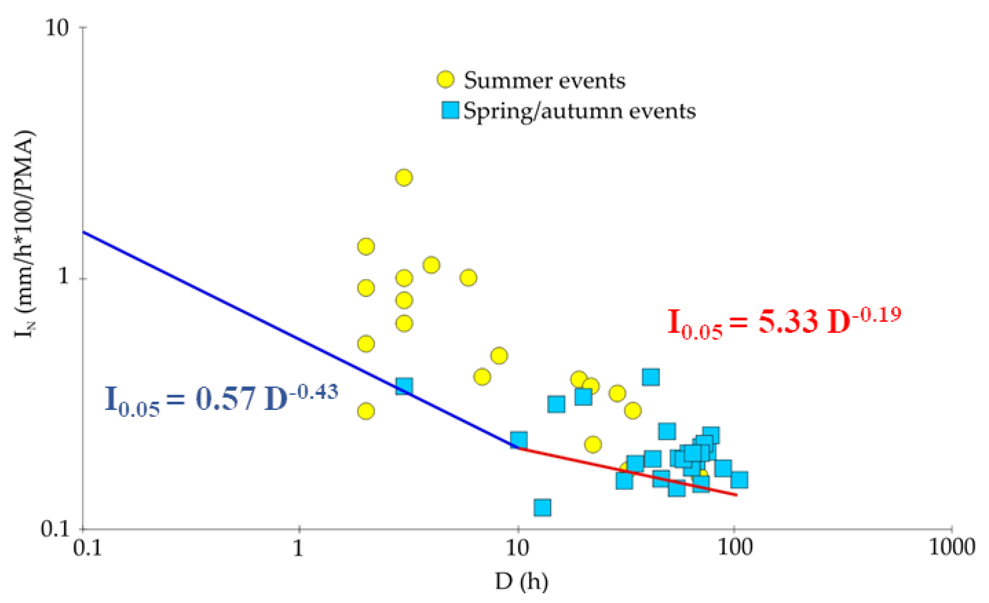
| Varese, Como, Lecco, and Bergamo (Equation (3)) | 86 | 0.57 | −0.43 | 0.2 < D < 10 | ||
| Varese, Como, Lecco, and Bergamo (Equation (4)) | 86 | 0.33 | −0.19 | 10 < D < 100 | ||
| Soil region thresholds | ||||||
| Soil region M1 (Equation (5)) | 241 | 3.330 | −0.379 | 0.522 | 0.024 | 1 < D < 110 |
| Soil region M2 (Equation (6)) | 102 | 18.465 | −0.532 | 1.184 | 0.038 | 1 < D < 106 |
| Soil texture thresholds | ||||||
| Coarse textured soils (Equation (7)) | 206 | 4.985 | −0.408 | 0.608 | 0.029 | 1 < D < 110 |
| Fine textured soils (Equation (8)) | 89 | 18.019 | −0.528 | 1.050 | 0.039 | 1 < D < 106 |
| Soil group thresholds | ||||||
| Cambisol coarse and skeletal soils (Equation (9)) | 107 | 5.087 | −0.393 | 0.706 | 0.038 | 1 < D < 110 |
| Cambisol fine soils (Equation (10)) | 68 | 17.141 | −0.534 | 1.234 | 0.049 | 1 < D < 106 |
| Umbrisol soils (Equation (11)) | 36 | 8.225 | −0.437 | 0.915 | 0.074 | 2 < D < 67 |
| Podzol soils (Equation (12)) | 27 | 8.868 | −0.426 | 0.939 | 0.070 | 1 < D < 70 |
| Reference thresholds | ||||||
| Sondrio and Brescia (Luino et al., 2019) [43] | 291 | 0.58 | −0.46 | 0.2 < D < 10 | ||
| Sondrio and Brescia (Luino et al., 2019) [43] | 291 | 0.31 | −0.19 | 10 < D < 100 | ||
| Lombardia (Ceriani et al., 1994) [96] | - | 20.10 | −0.550 | - | - | 1 < D < 1000 |
| Valtellina (Cancelli and Nova, 1985) [97] | - | 44.67 | −0.780 | - | - | 1 < D < 1000 |
Publisher’s Note: MDPI stays neutral with regard to jurisdictional claims in published maps and institutional affiliations. |
© 2022 by the authors. Licensee MDPI, Basel, Switzerland. This article is an open access article distributed under the terms and conditions of the Creative Commons Attribution (CC BY) license (https://creativecommons.org/licenses/by/4.0/).
Share and Cite
Luino, F.; De Graff, J.; Biddoccu, M.; Faccini, F.; Freppaz, M.; Roccati, A.; Ungaro, F.; D’Amico, M.; Turconi, L. The Role of Soil Type in Triggering Shallow Landslides in the Alps (Lombardy, Northern Italy). Land 2022, 11, 1125. https://doi.org/10.3390/land11081125
Luino F, De Graff J, Biddoccu M, Faccini F, Freppaz M, Roccati A, Ungaro F, D’Amico M, Turconi L. The Role of Soil Type in Triggering Shallow Landslides in the Alps (Lombardy, Northern Italy). Land. 2022; 11(8):1125. https://doi.org/10.3390/land11081125
Chicago/Turabian StyleLuino, Fabio, Jerome De Graff, Marcella Biddoccu, Francesco Faccini, Michele Freppaz, Anna Roccati, Fabrizio Ungaro, Michele D’Amico, and Laura Turconi. 2022. "The Role of Soil Type in Triggering Shallow Landslides in the Alps (Lombardy, Northern Italy)" Land 11, no. 8: 1125. https://doi.org/10.3390/land11081125