
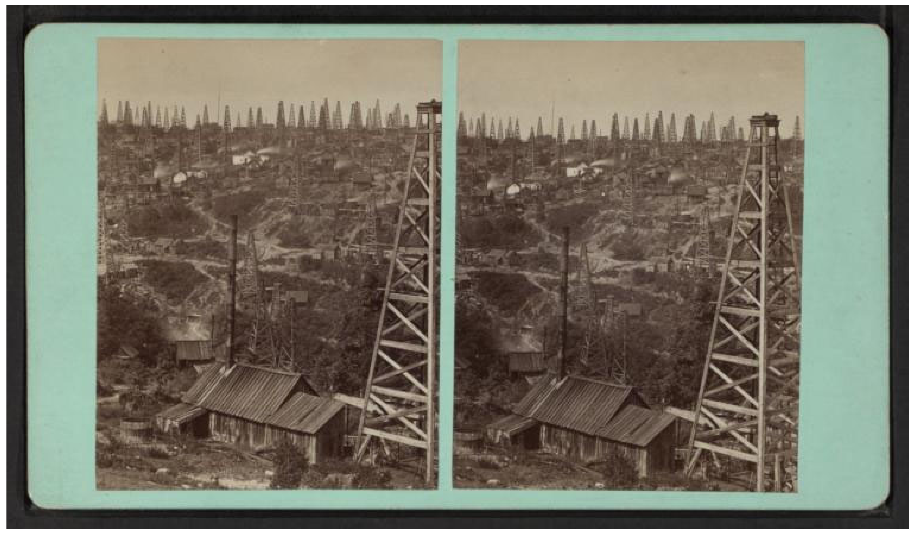
The Shaping of Daqing: Borderless Interactions between Oil and Urban Areas


Abstract
:1. Introduction
2. Theory
3. Methodology
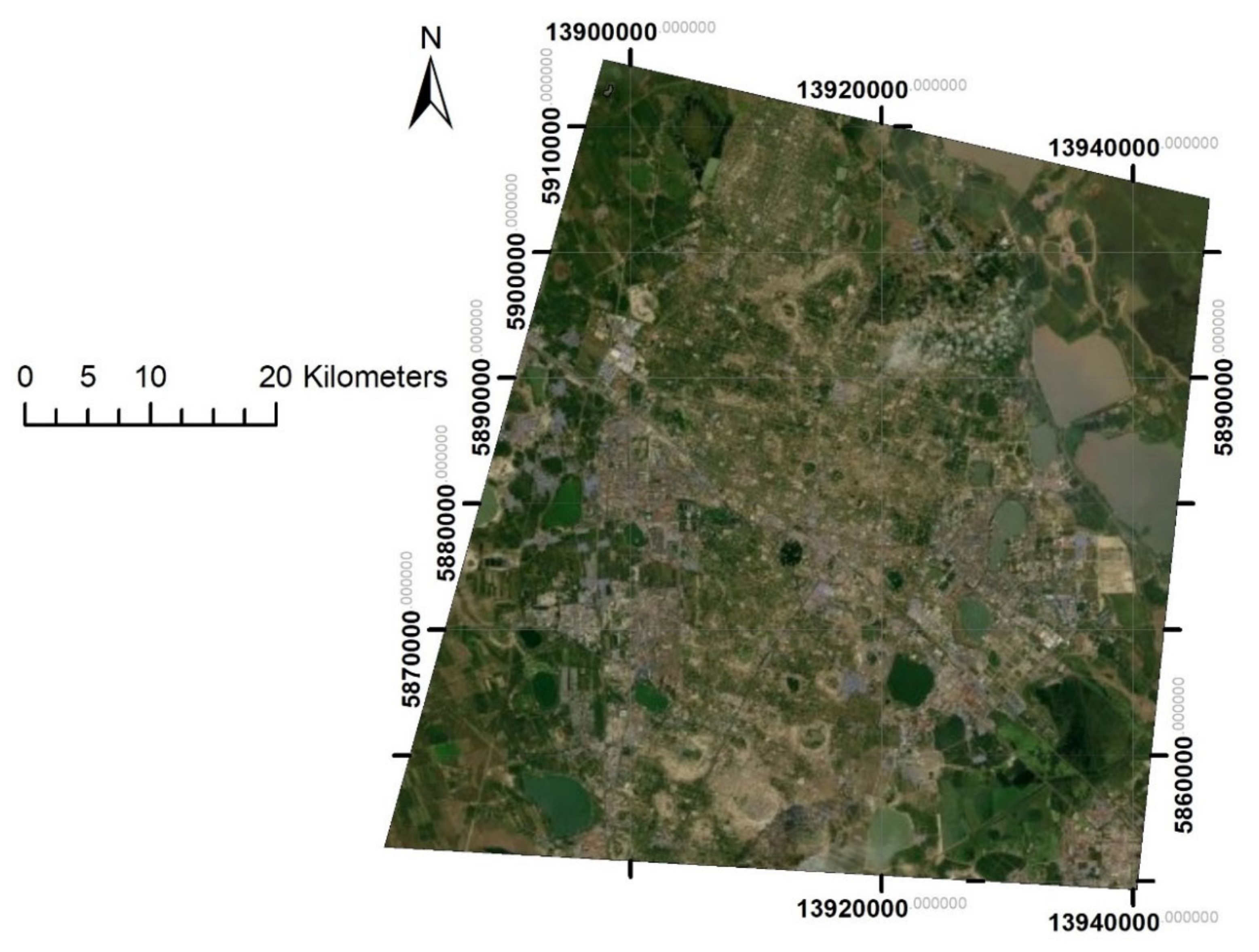
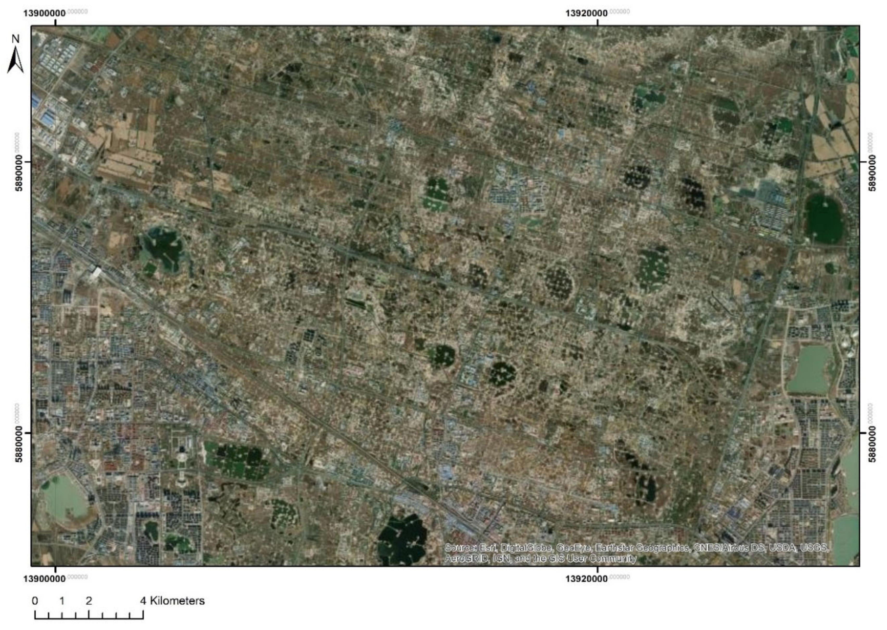
3.1. Case Study
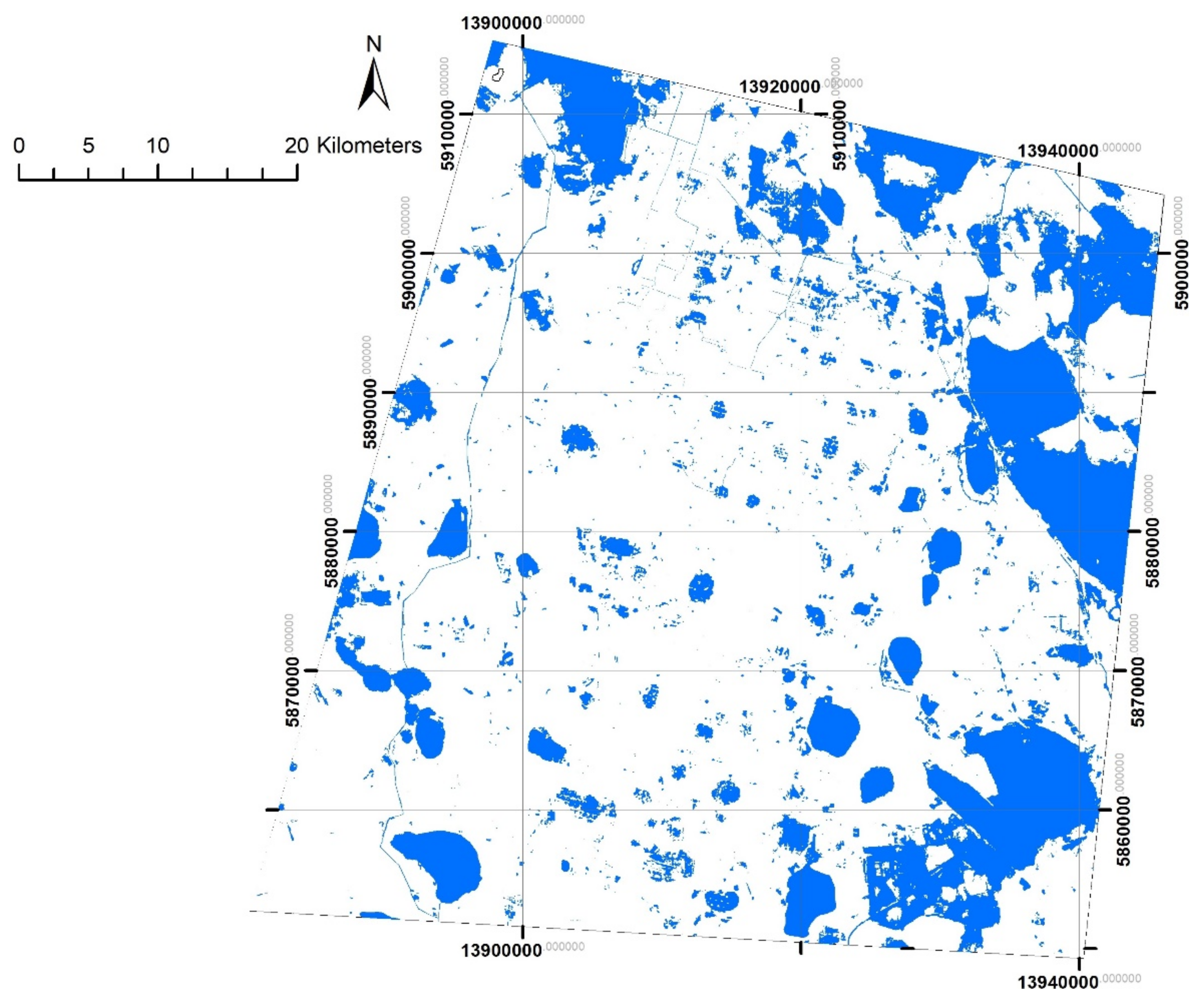
3.2. Mapping Method
3.3. Limitations
4. Analysis
5. Permeable Borders: Between Incompatibilities and Spreading
6. Conclusions
Author Contributions
Funding
Institutional Review Board Statement
Informed Consent Statement
Data Availability Statement
Acknowledgments
Conflicts of Interest
References
- Hein, C. Refineries (Oil). In Encyclopedia of Greater Philadelphia; Mid-Atlantic Regional Center for the Humanities: Camden, NY, USA, 2016. [Google Scholar]
- Hauser, S.; Zhu, P.; Mehan, A. 160 Years of Borders Evolution in Dunkirk: Petroleum, Permeability, and Porosity. Urban Plan. 2021, 6, 58–68. [Google Scholar] [CrossRef]
- Hein, C.; Stroobandt, C.; Hauser, S. Petroleumscape as Heritage Landscape: The Case of the Dunkirk Port City Region. In Oil Spaces: Exploring the Global Petroleumscape; Hein, C., Ed.; Routledge: London, UK, 2021. [Google Scholar]
- Hauser, S.J.; Aktürk, G. Investigate past polluting activities on public health and land uses. Cities 2022, 123, 103599. [Google Scholar] [CrossRef]
- Hauser, S.J. Long Live the Heritage of Petroleum: Discoveries of Former Oil Sites in the Port City of Dunkirk. Urban Sci. 2020, 4, 22. [Google Scholar] [CrossRef]
- Meadows, D.H.; Meadows, D.L.; Randers, J.; Behrens, W.W. The Limits to Growth: A Report for the Club of Rome’s Project on the Predicament of Mankind; New American Library: New York, NY, USA, 1972. [Google Scholar]
- Meadows, D.; Randers, J.; Meadows, D. Limits to Growth: The 30-Year Update; Chelsea Green Publishing: Chelsea, VT, USA, 2004. [Google Scholar]
- Aseeva, A. (Un)Sustainable Development(s) in International Economic Law: A Quest for Sustainability. Sustainability 2018, 10, 4022. [Google Scholar] [CrossRef] [Green Version]
- Turner, G. Is Global Collapse Imminent? University of Melbourne, Melbourne Sustainable Society Institute: Melbourne, Australia, 2014. [Google Scholar]
- Baron, S.; Carignan, J.; Ploquin, A. Dispersion of heavy metals (metalloids) in soils from 800-year-old pollution (Mont-Lozere, France). Environ. Sci. Technol. 2006, 40, 5319–5326. [Google Scholar] [CrossRef] [PubMed]
- Fernández-Navarro, P.; García-Pérez, J.; Ramis, R.; Boldo, E.; López-Abente, G. Industrial pollution and cancer in Spain: An important public health issue. Environ. Res. 2017, 159, 555–563. [Google Scholar] [CrossRef]
- Hatch, M.; Cardis, E. Somatic health effects of Chernobyl: 30 years on. Eur. J. Epidemiol. 2017, 32, 1047–1054. [Google Scholar] [CrossRef]
- Brimblecombe, P. Air pollution and health history. In Air Pollution and Health; Elsevier: Amsterdam, The Netherlands, 1999; pp. 5–18. [Google Scholar]
- Mosley, S. Environmental history of air pollution and protection. In The Basic Environmental History; Springer: Berlin/Heidelberg, Germany, 2014; pp. 143–169. [Google Scholar]
- Le Roux, T. La «médiatisation» de l’insalubrité industrielle: Un espace public de débats progressivement étouffé, 1770–1810. Temps Médias 2015, 2, 34–51. [Google Scholar] [CrossRef]
- Yergin, D. The Prize: The Epic Quest for Oil, Money & Power; Simon and Schuster: New York, NY, USA, 2011. [Google Scholar]
- Black, B.C. How World War I ushered in the century of oil. Observer. 2018. Available online: https://observer.com/2017/04/world-war-i-ushered-in-the-century-of-oil-global-economy-geopolitics-national-security/ (accessed on 14 December 2020).
- McQuaig, L. It’s the Crude, Dude: War, Big Oil and the Fight for the Planet; Doubleday: Toronto, ON, Canada, 2004. [Google Scholar]
- Tateo, L.; Nugin, R.; Jones, A.; Marsico, G.; Palang, H. Cities of Senses: Visible and Invisible Borders in Public Spaces. In Identity at the Borders and Between the Borders; Springer: Berlin/Heidelberg, Germany, 2021; pp. 7–22. [Google Scholar]
- Churski, P.; Herodowicz, T.; Konecka-Szydłowska, B.; Perdał, R. Spatial Differentiation of the Socio-Economic Development of Poland–“Invisible” Historical Heritage. Land 2021, 10, 1247. [Google Scholar] [CrossRef]
- Jovchelovitch, S.; Dedios Sanguineti, M.C.; Nogueira, M.; Priego-Hernandez, J. Imagination and mobility in the city: Porosity of borders and human development in divided urban environments. Cult. Psychol. 2020, 26, 676–696. [Google Scholar] [CrossRef] [Green Version]
- Roulleau-Berger, L. Metropolitanization, Interior Borders, and Invisible Cities in China. Espac. Soc. 2013, 155, 129–141. [Google Scholar]
- Pierson, P. Increasing returns, path dependence, and the study of politics. Am. Polit. Sci. Rev. 2000, 94, 251–267. [Google Scholar] [CrossRef]
- Hacker, J.S.; Pierson, P. Winner-Take-All Politics: How Washington Made the Rich Richer—And Turned its Back on the Middle Class, 1st ed.; Simon and Schuster: New York, NY, USA, 2010; ISBN 1416588701. [Google Scholar]
- Sorensen, A. Taking path dependence seriously: An historical institutionalist research agenda in planning history. Plan. Perspect. 2015, 30, 17–38. [Google Scholar] [CrossRef]
- Ramos, S.J. Resilience, path dependence, and the port: The case of Savannah. J. Urban Hist. 2017, 47, 0096144217704183. [Google Scholar] [CrossRef]
- Hafez, T.; Ortiz-Zarragoitia, M.; Cagnon, C.; Cravo-Laureau, C.; Duran, R. Legacy and dispersant influence microbial community dynamics in cold seawater contaminated by crude oil water accommodated fractions. Environ. Res. 2022, 212, 113467. [Google Scholar] [CrossRef]
- Okoye, C.O.; Addey, C.I.; Oderinde, O.; Okoro, J.O.; Uwamungu, J.Y.; Ikechukwu, C.K.; Okeke, E.S.; Ejeromedoghene, O.; Odii, E.C. Toxic Chemicals and Persistent Organic Pollutants Associated with Micro-and Nanoplastics Pollution. Chem. Eng. J. Adv. 2022, 11, 100310. [Google Scholar] [CrossRef]
- Liu, Q.; Xia, C.; Wang, L.; Tang, J. Fingerprint analysis reveals sources of petroleum hydrocarbons in soils of different geographical oilfields of China and its ecological assessment. Sci. Rep. 2022, 12, 4808. [Google Scholar] [CrossRef]
- Otitolaiye, V.O.; Al-Harethiya, G.M. Impacts of petroleum refinery emissions on the health and safety of local residents. J. Air Pollut. Health 2022, 7, 69–80. [Google Scholar] [CrossRef]
- Eklund, R.L.; Knapp, L.C.; Sandifer, P.A.; Colwell, R.C. Oil spills and human health: Contributions of the Gulf of Mexico Research Initiative. GeoHealth 2019, 3, 391–406. [Google Scholar] [CrossRef]
- Sam, K.; Coulon, F.; Prpich, G. Management of petroleum hydrocarbon contaminated sites in Nigeria: Current challenges and future direction. Land Use Policy 2017, 64, 133–144. [Google Scholar] [CrossRef] [Green Version]
- Yanxun, S.; Yani, W.; Hui, Q.; Yuan, F. Analysis of the groundwater and soil pollution by oil leakage. Procedia Environ. Sci. 2011, 11, 939–944. [Google Scholar] [CrossRef] [Green Version]
- Borowik, A.; Wyszkowska, J.; Kucharski, M.; Kucharski, J. Implications of soil pollution with diesel oil and BP petroleum with ACTIVE Technology for soil health. Int. J. Environ. Res. Public Health 2019, 16, 2474. [Google Scholar] [CrossRef] [PubMed] [Green Version]
- Hartley, W.R.; Englande, A.J., Jr. Health risk assessment of the migration of unleaded gasoline–a model for petroleum products. Water Sci. Technol. 1992, 25, 65–72. [Google Scholar] [CrossRef]
- Nelson, R.; Heo, J. Monitoring environmental parameters with oil and gas developments in the Permian Basin, USA. Int. J. Environ. Res. Public Health 2020, 17, 4026. [Google Scholar] [CrossRef]
- Hein, C.; Sedighi, M. Iran’s Global Petroleumscape: The Role of Oil in Shaping Khuzestan and Tehran. Archit. Theory Rev. 2016, 21, 349–374. [Google Scholar] [CrossRef] [Green Version]
- Hein, C. Oil Spaces: The Global Petroleumscape in the Rotterdam/The Hague Area. J. Urban Hist. 2018, 44, 887–929r. [Google Scholar] [CrossRef] [Green Version]
- Editorial Group of Daqing City. Local Record Record of Daqing; Nanjing Publishing House: Nanjing, China, 1988. [Google Scholar]
- Leading Group of the Songliao Petroleum Congress of the Ministry of Petroleum Industry (Acting). Notice on the Division of Labour among the Leading Members of the Songliao Petroleum Congress of the Ministry of Petroleum Industry; Ministry of Petroleum Industry: Beijing, China, 1960.
- Xinhua News Agency. The Employees of the Daqing Oilfield are Proud of Living in ‘Gandalei’ Houses; Xinhua News Agency: Beijing, China, 1966. [Google Scholar]
- Editorial Group of the CCP’s History in Daqing. The History of Daqing’s Reform and Opening up 1978–2009; History of Chinese Communist Party Publishing House: Beijing, China, 2010; pp. 87–99. [Google Scholar]
- Pei, X.; Yang, Z.; Li, B.; Yaning, L. History and actuality of separate layer oil production technologies in Daqing Oilfield. In Proceedings of the International Oil & Gas Conference and Exhibition in China, OnePetro, Beijing, China, 5–7 December 2006. [Google Scholar]
- The Editorial Group of Daqing Land and Resources. Daqing Land and Resource; People’s Publisher of Heilongjiang Province: Harbin, China, 1989. [Google Scholar]
- Zhou, Y.; Guan, L.; Zhong, S. The Comprehensive Land Use Plan in Daqing; Heilongjiang Science and Technology Press: Harbin, China, 1992. [Google Scholar]
- Aktürk, G.; Hauser, S.J. Detection of Disaster-Prone Vernacular Heritage Sites at District Scale: The Case of Fındıklı in Rize, Turkey. Int. J. Disaster Risk Reduct. 2021, 58, 102238. [Google Scholar] [CrossRef]
- Grimaz, S.; Allen, S.; Stewart, J.R.; Dolcetti, G. Fast prediction of the evolution of oil penetration into the soil immediately after an accidental spillage for rapid-response purposes. In Proceedings of the 3rd International Conference on Safety & Environment in Process Industry, CISAP–3, Rome (I), Citeseer, Rome, Italy, 11–14 May 2008; pp. 11–14. [Google Scholar]
- Alloway, B.J. Soil pollution and land contamination. Pollut. Causes Eff. Control 1996, 3, 318–339. [Google Scholar]
- Okandan, E.; Gümrah, F.; Demiral, B. Pollution of an aquifer by produced oil field water. Energy Sources 2001, 23, 327–336. [Google Scholar]
- Ejike, C.; Eferibe, C.; Okonkwo, F. Concentrations of some heavy metals in underground water samples from a Nigerian crude oil producing community. Environ. Sci. Pollut. Res. 2017, 24, 8436–8442. [Google Scholar] [CrossRef]
- United States Environmental Protection Agency Office of Emergency Remedial Response and United States Environmental Protection Agency Emergency Response Division. Understanding Oil Spills and Oil Spill Response; Environmental Protection Agency, Office of Emergency and Remedial Response [and] Emergency Response Division: Washington, DC, USA, 1993; Volume 93.
- Arockiaraj, S.; Kankara, R.S. Assessment of Potential Oil Spill Risk Along Vishakhaptnam Coast, India: Integrated Approach for Coastal Management. In Coastal Management; Elsevier: Amsterdam, The Netherlands, 2019; pp. 449–463. [Google Scholar]
- Scovronick, N.; Wilkinson, P. Health impacts of liquid biofuel production and use: A review. Glob. Environ. Change 2014, 24, 155–164. [Google Scholar] [CrossRef]
- Roulet, N.T. Hydrology of a headwater basin wetland: Groundwater discharge and wetland maintenance. Hydrol. Process. 1990, 4, 387–400. [Google Scholar] [CrossRef]
- McCarthy, T.S. Groundwater in the wetlands of the Okavango Delta, Botswana, and its contribution to the structure and function of the ecosystem. J. Hydrol. 2006, 320, 264–282. [Google Scholar] [CrossRef]
- Wang, X.; Zang, S. Distribution characteristics and ecological risk assessment of toxic heavy metals and metalloid in surface water of lakes in Daqing Heilongjiang Province, China. Ecotoxicology 2014, 23, 609–617. [Google Scholar] [CrossRef]
- Granot, H. The dark side of growth and industrial disasters since the Second World War. Disaster Prev. Manag. Int. J. 1998, 7, 195–204. [Google Scholar] [CrossRef]
- Woolfson, C. Preventable disasters in the offshore oil industry: From Piper Alpha to Deepwater Horizon. New Solut. J. Environ. Occup. Health Policy 2013, 22, 497–524. [Google Scholar] [CrossRef]
- Rosell-Melé, A.; Moraleda-Cibrián, N.; Cartró-Sabaté, M.; Colomer-Ventura, F.; Mayor, P.; Orta-Martínez, M. Oil pollution in soils and sediments from the Northern Peruvian Amazon. Sci. Total Environ. 2018, 610, 1010–1019. [Google Scholar] [CrossRef]
- Sun, Y.; Lu, S.; Zhao, X.; Ding, A.; Wang, L. Long-term oil pollution and in situ microbial response of groundwater in Northwest China. Arch. Environ. Contam. Toxicol. 2017, 72, 519–529. [Google Scholar] [CrossRef]
- Hose, G.C.; Bailey, J.; Stumpp, C.; Fryirs, K. Groundwater depth and topography correlate with vegetation structure of an upland peat swamp, Budderoo Plateau, NSW, Australia. Ecohydrology 2014, 7, 1392–1402. [Google Scholar] [CrossRef]
- Wang, J.F.; Xu, L.; Xu, W.P.; Liu, X.T. The Research of Microbial Remediation of Oil Pollution Wetland—Aim at the Oil Pollution of Daqing Oil Field the Wetland. Adv. Mater. Res. 2013, 610, 2074–2078. [Google Scholar]
- Wu, T.; Wang, L.; Wang, L.; Kong, Q. Evaluation of groundwater quality and pollution in Daqing Oilfield. J. Groundw. Sci. Eng. 2018, 6, 40–48. [Google Scholar]
- Zhang, H.; Bian, J.; Wan, H. Hydrochemical appraisal of groundwater quality and pollution source analysis of oil field area: A case study in Daqing City, China. Environ. Sci. Pollut. Res. 2021, 28, 18667–18685. [Google Scholar] [CrossRef] [PubMed]
- Brinkmann, F.J.J. Lekkerkerk. In Proceedings of the Studies in Environmental Science, Noordwijkerhout, The Netherlands, 23–27 March 1981; Volume 17. [Google Scholar]
- Almer, C.; Winkler, R. Analyzing the effectiveness of international environmental policies: The case of the Kyoto Protocol. J. Environ. Econ. Manag. 2017, 82, 125–151. [Google Scholar] [CrossRef] [Green Version]
- Churchman, C.W. Guest Editorial: Wicked Problems; INFORMS: Catonsville, MD, USA, 1967. [Google Scholar]
- Rittel, H.W.J.; Webber, M.M. Dilemmas in a general theory of planning. Policy Sci. 1973, 4, 155–169. [Google Scholar] [CrossRef]
- Weber, E.P.; Khademian, A.M. Wicked problems, knowledge challenges, and collaborative capacity builders in network settings. Public Adm. Rev. 2008, 68, 334–349. [Google Scholar] [CrossRef]
- Levin, K.; Cashore, B.; Bernstein, S.; Auld, G. Overcoming the tragedy of super wicked problems: Constraining our future selves to ameliorate global climate change. Policy Sci. 2012, 45, 123–152. [Google Scholar] [CrossRef]
- De Abreu, M.C.S.; de Andrade, R. Dealing with wicked problems in socio-ecological systems affected by industrial disasters: A framework for collaborative and adaptive governance. Sci. Total Environ. 2019, 694, 133700. [Google Scholar] [CrossRef]


Publisher’s Note: MDPI stays neutral with regard to jurisdictional claims in published maps and institutional affiliations. |
© 2022 by the authors. Licensee MDPI, Basel, Switzerland. This article is an open access article distributed under the terms and conditions of the Creative Commons Attribution (CC BY) license (https://creativecommons.org/licenses/by/4.0/).
Share and Cite
Hauser, S.J.; Zhu, P. The Shaping of Daqing: Borderless Interactions between Oil and Urban Areas. Land 2022, 11, 1120. https://doi.org/10.3390/land11071120
Hauser SJ, Zhu P. The Shaping of Daqing: Borderless Interactions between Oil and Urban Areas. Land. 2022; 11(7):1120. https://doi.org/10.3390/land11071120
Chicago/Turabian StyleHauser, Stephan J., and Penglin Zhu. 2022. "The Shaping of Daqing: Borderless Interactions between Oil and Urban Areas" Land 11, no. 7: 1120. https://doi.org/10.3390/land11071120