
Ancient Agricultural and Pastoral Landscapes on the South Side of Lake Issyk-Kul: Long-Term Diachronic Analysis of Changing Patterns of Land Use, Climate Change, and Ritual Use in the Juuku and Kizil Suu Valleys

 ,
,
Abstract
:1. Introduction
2. Materials and Methods
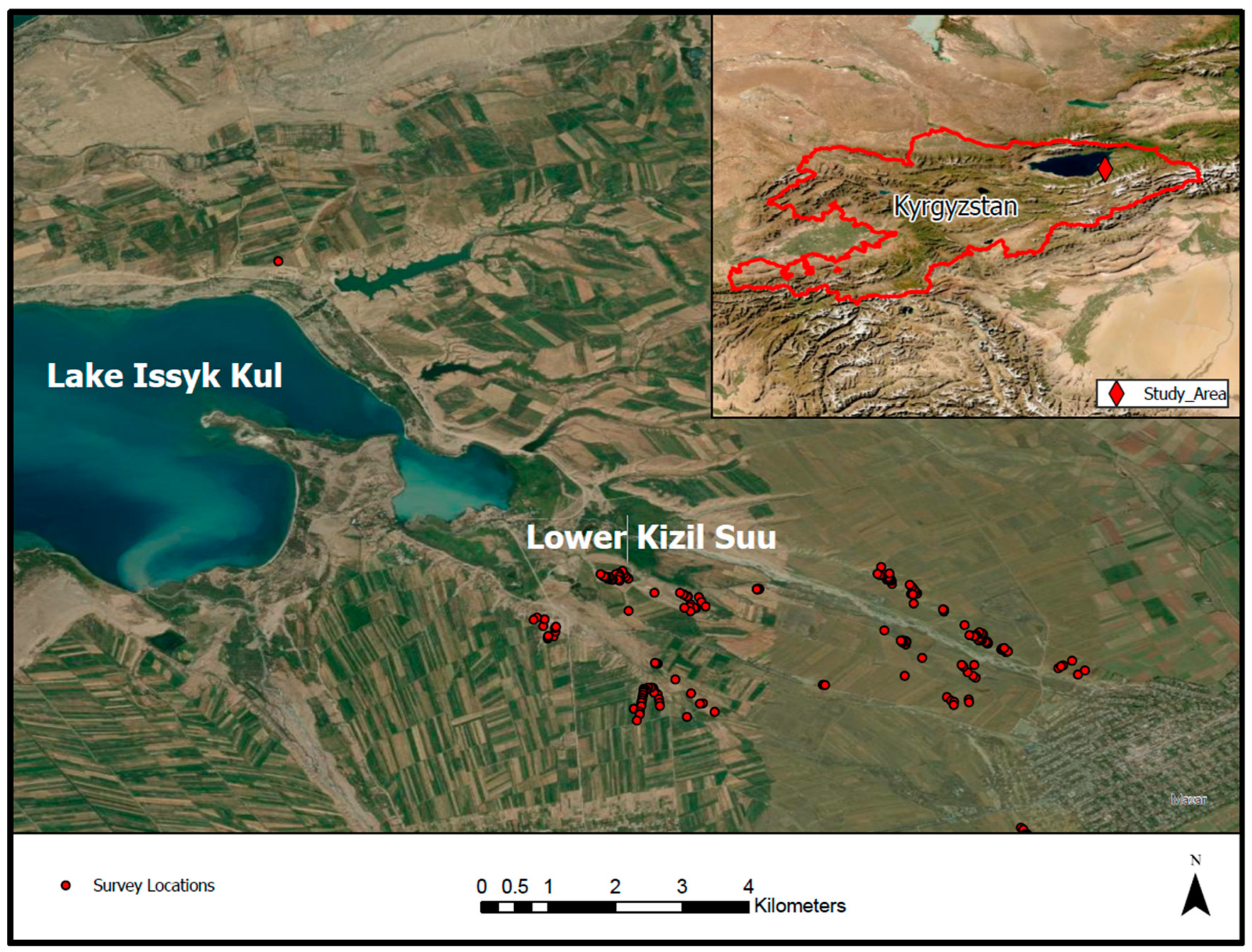
2.1. Study Area
2.2. Description of Survey Methods
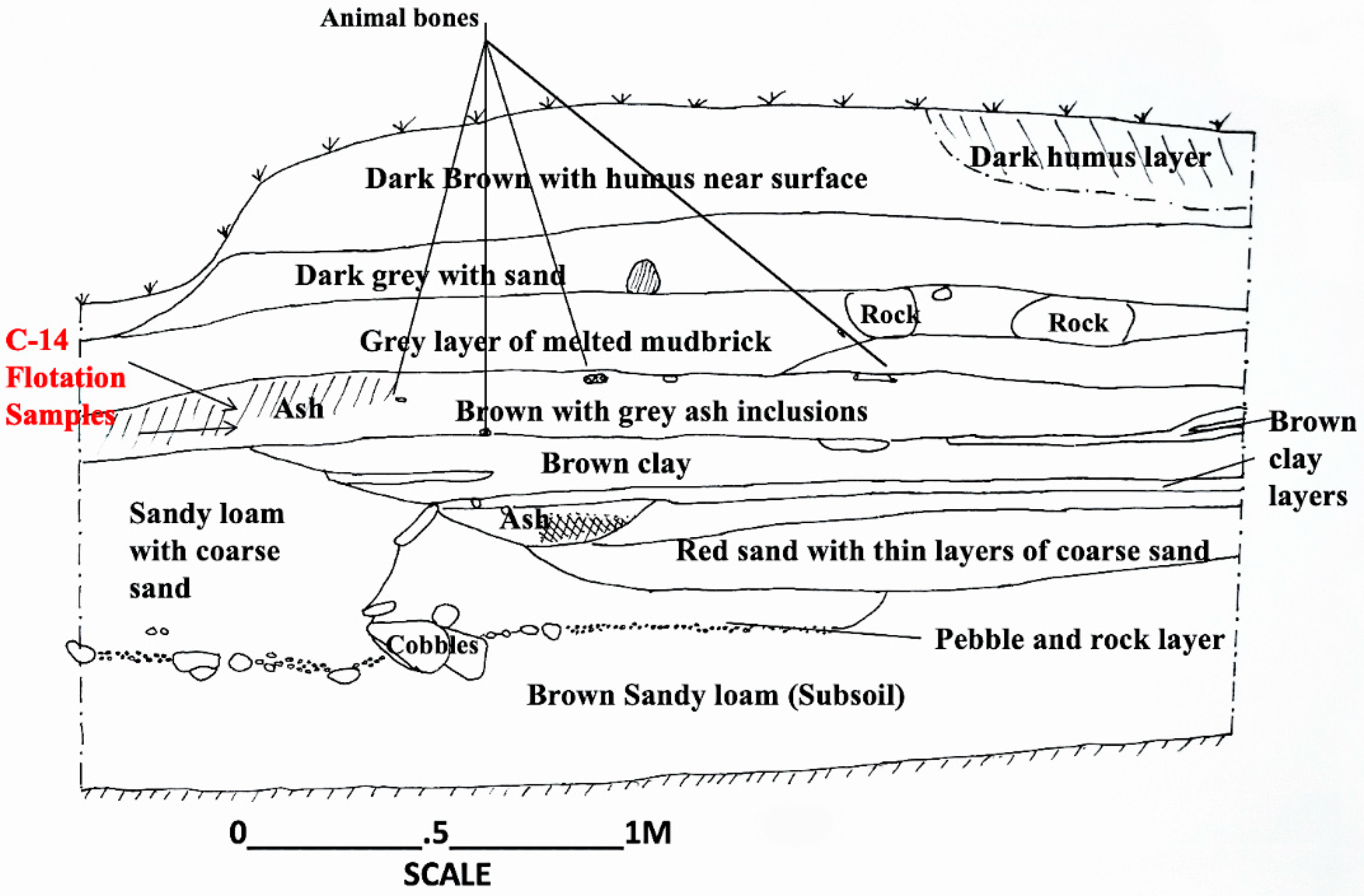
2.3. Stratigraphic Profiles at Juuku Valley Settlements
2.4. Radiometric Dating
2.5. Archaeobotanical Methods
2.6. ArcGIS Methods for Spatial Analysis
3. Results
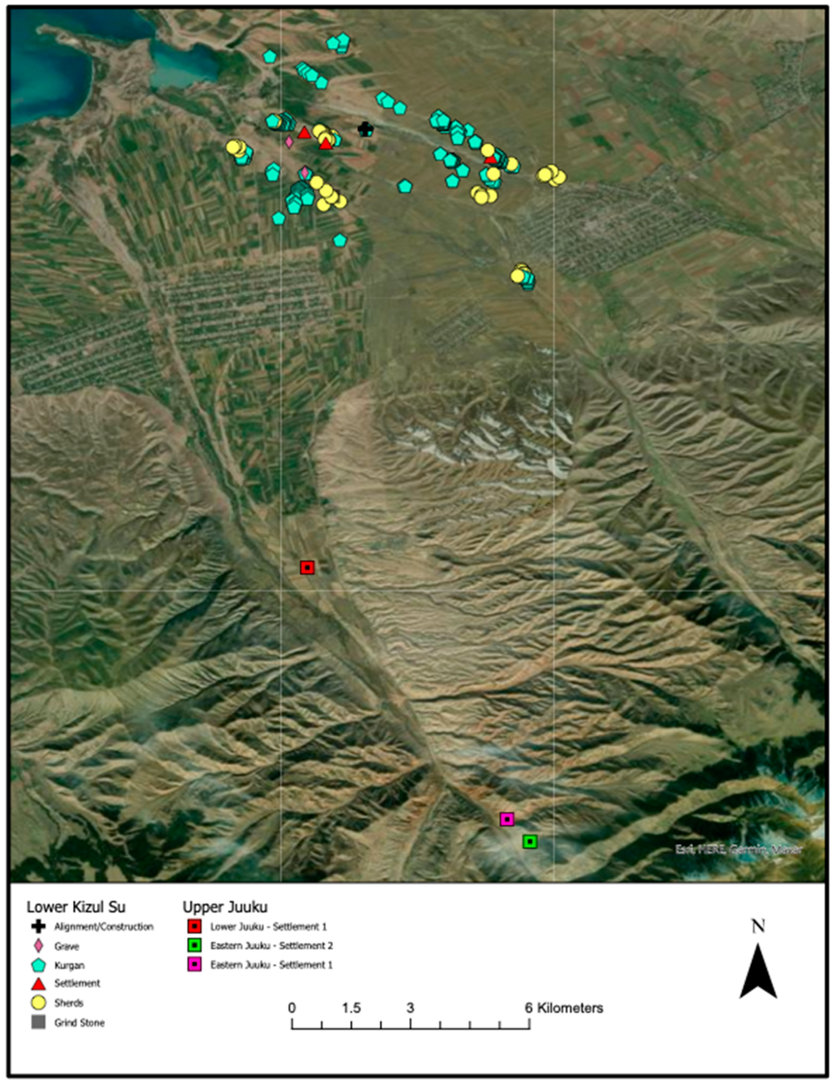
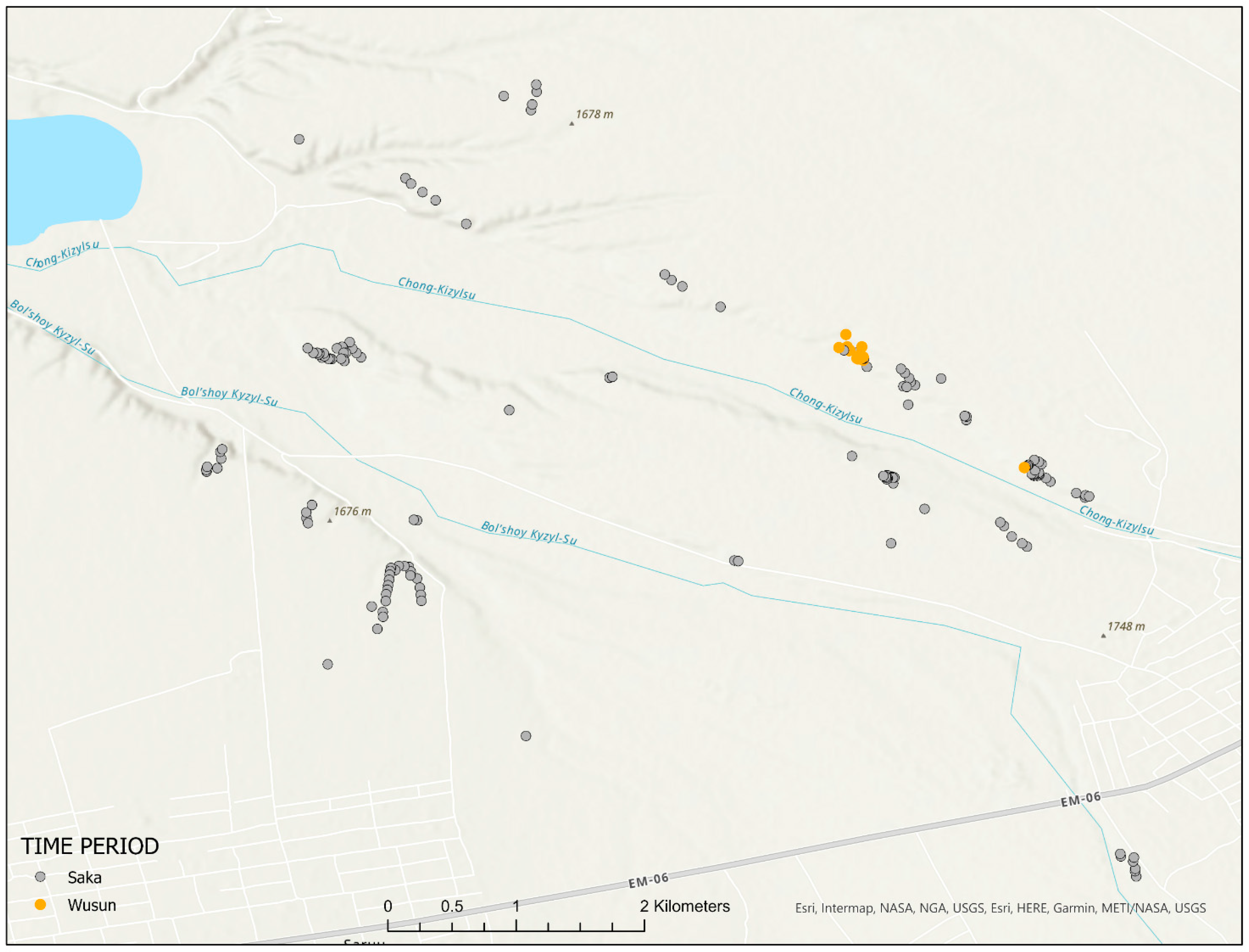
3.1. Survey Results
3.2. Stratigraphic Profiles
3.2.1. Profile at Site-EJS1 (Wusun Period Settlement)
3.2.2. Profile at Site-EJS2 (Qarakhanid Period Settlement)
3.3. Results of Radiometric Dating
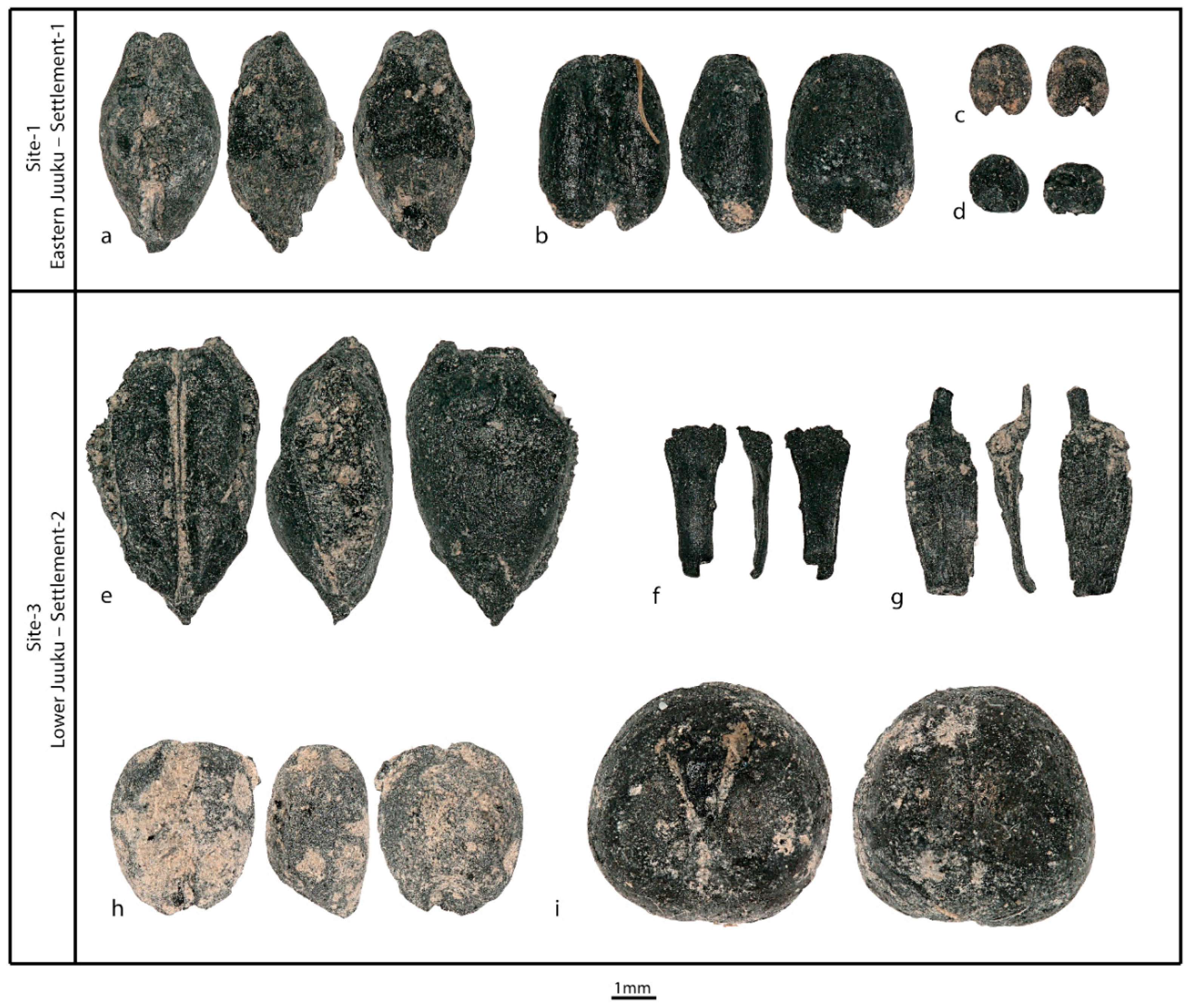
3.4. Results of Archaeobotanical Analyses
3.4.1. Eastern Juuku-Settlement 1, 1st–5th Centuries CE
3.4.2. Eastern Juuku-Settlement 2, 10th to 11th Centuries CE
3.4.3. Lower Juuku-Settlement 1, 17th to 19th Centuries CE
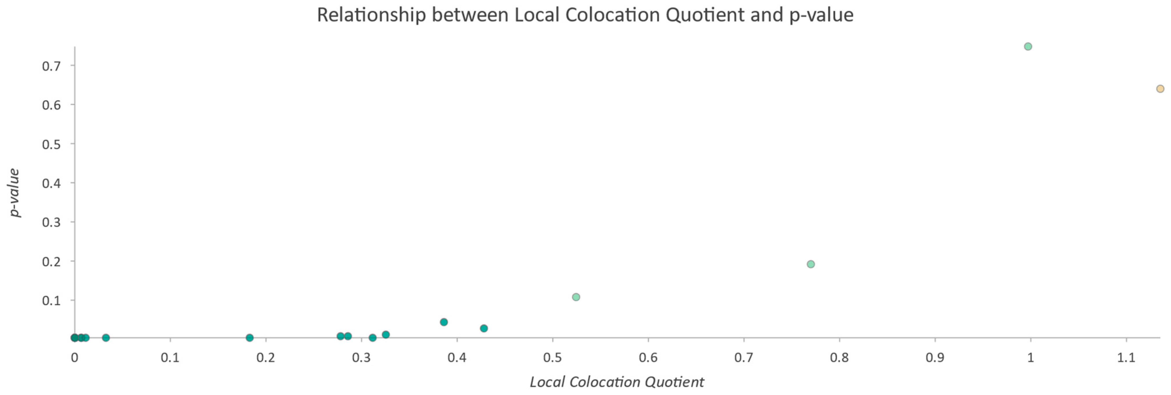
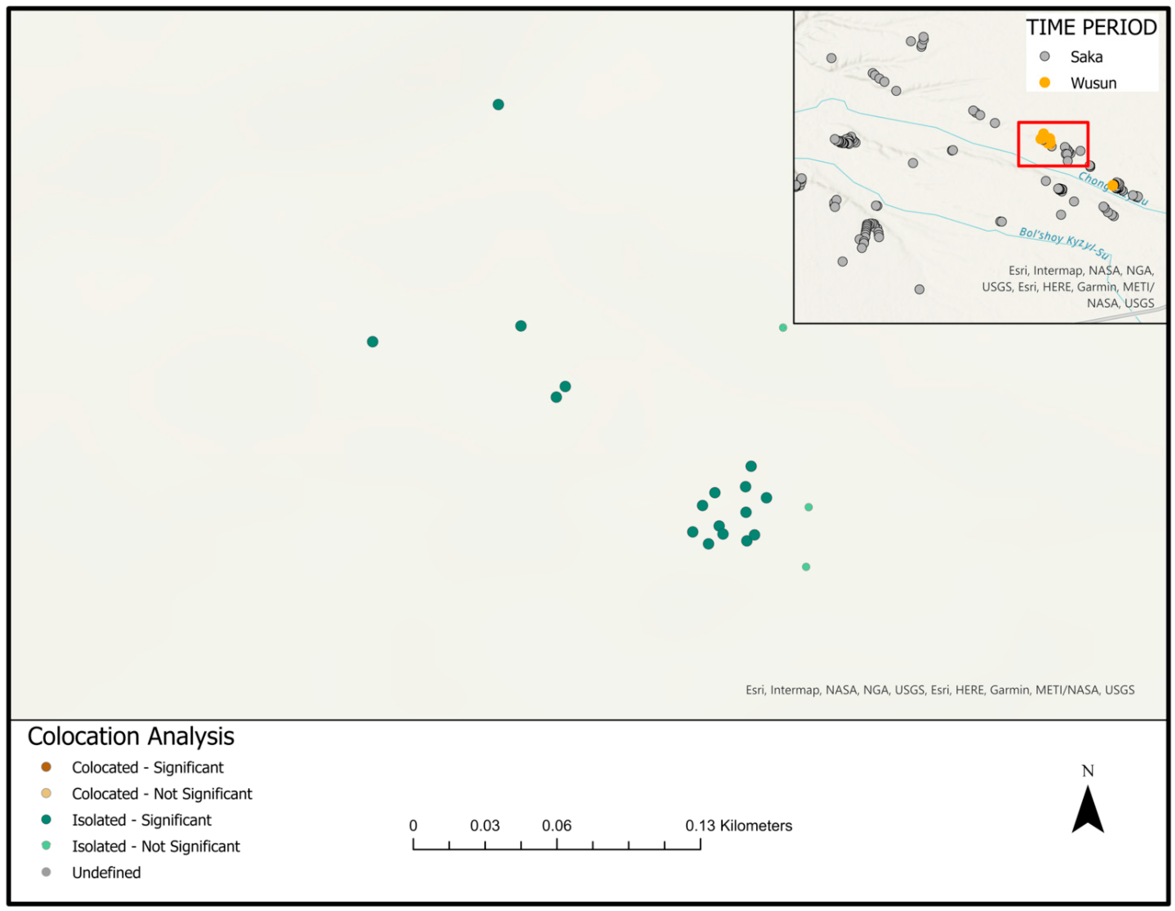
3.5. Results of the ArcGIS Spatial Analyses
4. Discussion
5. Conclusions
Author Contributions
Funding
Institutional Review Board Statement
Data Availability Statement
Acknowledgments
Conflicts of Interest
References
- Chang, C.; Ivanov, S.S.; Tourtellotte, P.A. Landscape and Settlement over 4 Millennia on the South Side of Lake Issyk Kul, Kyrgyzstan: Preliminary Results of Survey Research in 2019–2021. Land 2022, 11, 456. [Google Scholar] [CrossRef]
- Frachetti, M.D. Multiregional Emergence of Mobile Pastoralism and Nonuniform Institutional Complexity across Eurasia. Curr. Anthr. 2012, 53, 2–38. [Google Scholar] [CrossRef] [Green Version]
- Gokcumen, O.; Frachetti, M. The Impact of Ancient Genome Studies in Archaeology. Annu. Rev. Anthr. 2020, 49, 277–298. [Google Scholar] [CrossRef]
- Unterländer, M.; Palstra, F.; Lazaridis, I.; Pilipenko, A.; Hofmanová, Z.; Groß, M.; Sell, C.; Blöcher, J.; Kirsanow, K.; Rohland, N.; et al. Ancestry and demography and descendants of Iron Age nomads of the Eurasian Steppe. Nat. Commun. 2017, 8, 14615. [Google Scholar] [CrossRef]
- Ventresca Miller, A.R.; Makarewicz, C.A. Isotopic approaches to pastoralism in prehistory: Diet, mobility, and isotopic reference sets. In Isotopic Investigations of Pastoralism in Prehistory; Routledge Press: Abingdon, UK, 2017; pp. 1–14. [Google Scholar]
- Hermes, T.R.; Frachetti, M.D.; Doumani Dupuy, P.N.D.; Mar’Yashev, A.; Nebel, A.; Makarewicz, C.A. Early integration of pastoralism and millet cultivation in Bronze Age Eurasia. Proc. R. Soc. B 2019, 286, 20191273. [Google Scholar] [CrossRef]
- Spengler, R.N., III; Miller, A.V.; Schmaus, T.; Matuzevičiūtė, G.M.; Miller, B.K.; Wilkin, S.; Taylor, W.T.T.; Li, Y.; Roberts, P.; Boivin, N. An Imagined Past? Nomadic Narratives in Central Asian Archaeology. Curr. Anthropol. 2021, 62, 251–286. [Google Scholar] [CrossRef]
- Ventresca Miller, A.R.V.; Haruda, A.; Varfolomeev, V.; Goryachev, A.; Makarewicz, C.A. Close management of sheep in ancient Central Asia: Evidence for foddering, transhumance, and extended lambing seasons during the Bronze and Iron Ages. STAR Sci. Technol. Archaeol. Res. 2020, 6, 41–60. [Google Scholar] [CrossRef]
- Matuzeviciute, G.M.; Mir-Makhamad, B.; Tabaldiev, K. The first comprehensive archaeobotanical analysis of prehistoric agriculture in Kyrgyzstan. Veg. Hist. Archaeobot. 2021, 30, 743–758. [Google Scholar] [CrossRef]
- Ullah, I.I.; Chang, C.; Tourtellotte, P. Water, dust, and agro-pastoralism: Modeling socio-ecological co-evolution of landscapes, farming, and human society in southeast Kazakhstan during the mid to late Holocene. J. Anthr. Archaeol. 2019, 55, 101067. [Google Scholar] [CrossRef]
- Betts, A.; Jia, P.; Abuduresule, I. A new hypothesis for early Bronze Age cultural diversity in Xinjiang, China. Archaeol. Res. Asia 2019, 17, 204–213. [Google Scholar] [CrossRef]
- Li, Y.; Storozum, M.; Tian, D.; Frachetti, M.; Su, K.; Wang, X. Farming strategies of 1st millennium CE agro-pastoralists on the southern foothills of the Tianshan Mountains: A geoarchaeological and macrobotanical investigation of the Mohuchahangoukou (MGK) site, Xinjiang, China. PLoS ONE 2019, 14, e0217171. [Google Scholar] [CrossRef] [PubMed] [Green Version]
- Spate, M.; Yatoo, M.A.; Penny, D.; Shah, M.A.; Betts, A. Palaeoenvironmental proxies indicate long-term development of agro-pastoralist landscapes in Inner Asian mountains. Sci. Rep. 2022, 12, 54. [Google Scholar] [CrossRef] [PubMed]
- Khazanov, A.M. Nomads and the Outside World, 2nd ed.; The University of Wisconsin Press: Madison, WI, USA, 1994; pp. 232–262. [Google Scholar]
- Kradin, N. Nomadic empires in inner Asia. In Complexity of Interaction along the Eurasian Steppe Zone in the First Millennium CE; Vfgarchpress: Bonn, Germany, 2015; pp. 11–48. [Google Scholar]
- Masanov, N.E. Kochevaya Tsivilizatsiya Kazkakhov: Osnov’i Zhisznedelatmel’nosti Nomadnogo Obshestsva (Nomadic Kazakh Civilization: The Foundation of Nomadic Society; Sostinvest: Almaty, Kazakhstan; Moscowand, Russia, 1995. (In Russian) [Google Scholar]
- Dyson-Hudson, N. The Study of Nomads. In Perspectives on Nomadism; Irons, W., Dyson-Hudson, N., Eds.; E.J. Brill: Leiden, The Netherlands, 1972; pp. 2–29. [Google Scholar]
- Anthony, D.W. The Horse, the Wheel and Language; How Bronze-Age Riders from the Eurasian Steppes Shaped the Modern World; Princeton University Press: Princeton, NJ, USA; Oxford, UK, 2007. [Google Scholar]
- Beisenov, A.Z.; Svyatko, S.V.; Duysenbay, D.B.; Akhiyarov, I.K.; Reimer, P.J.; Arkheologiya, P. New Isotopic Data on the Diet of the Saka Period Population from Central Kazakhstan. Povolzhskaya Arkheologiya (Volga River Reg. Archaeol.) 2020, 3, 208–218. [Google Scholar] [CrossRef]
- Spengler, R.; Miller, N.; Neef, R.; Tourtellotte, P.A.; Chang, C. Linking agriculture and exchange to social developments of the Central Asian Iron Age. J. Anthr. Archaeol. 2017, 48, 295–308. [Google Scholar] [CrossRef]
- Miller, A.R.V.; Spengler, R.; Haruda, A.; Miller, B.; Wilkin, S.; Robinson, S.; Roberts, P.; Boivin, N. Ecosystem Engineering Among Ancient Pastoralists in Northern Central Asia. Front. Earth Sci. 2020, 8, 168. [Google Scholar] [CrossRef]
- Matuzeviciute, G.M.; Ananyevskaya, E.; Sakalauskaite, J.; Soltobaev, O.; Tabaldiev, K. The integration of millet into the diet of Central Asian populations in the third millennium BC. Antiquity 2022, 96, 560–574. [Google Scholar] [CrossRef]
- Caspari, G.; Betts, A.; Jia, P. The Bronze Age in the Western Tianshan, China: A new model for determining seasonal use of sites. J. Archaeol. Sci. Rep. 2017, 14, 12–20. [Google Scholar] [CrossRef]
- Tian, D.; Festa, M.; Cong, D.; Zhao, Z.; Jia, P.W.; Betts, A. New evidence for supplementary crop production, foddering and fuel use by Bronze Age transhumant pastoralists in the Tianshan Mountains. Sci. Rep. 2021, 11, 13718. [Google Scholar] [CrossRef]
- Rouse, L.M.; Krumnow, J. On the fly: Strategies for UAV-based archaeological survey in mountainous areas of Central Asia and their implications for landscape research. J. Archaeol. Sci. Rep. 2020, 30, 102275. [Google Scholar] [CrossRef]
- Rouse, L.M.; Tabaldiev, K.; Matuzeviciute, G.M. Exploring Landscape Archaeology and UAV-Based Survey in the Kochkor Valley, Kyrgyzstan. J. Field Archaeol. 2021, 47, 32–53. [Google Scholar] [CrossRef]
- Frachetti, M.D.; Smith, C.E.; Traub, C.; Williams, T. Nomadic ecology shaped the highland geography of Asia’s Silk Roads. Nature 2017, 543, 193–198. [Google Scholar] [CrossRef] [PubMed]
- Dupuy, P.N.D.; Zhuniskhanov, A.S.; Bullion, E.A.; Kiyasbek, G.K.; Tashmanbetova, Z.K.; Rakhmankulov, E.Z.; Isin, A.I. The newly discovered bronze age site of Koken: Merging micro-regions with major study zones in the high steppes of Kazakhstan. Archaeol. Res. Asia 2021, 27, 100292. [Google Scholar] [CrossRef]
- Rouse, L.M.; Cerasetti, B. Ojakly: A Late Bronze Age mobile pastoralist site in the Murghab Region, Turkmenistan. J. Field Archaeol. 2014, 39, 32–50. [Google Scholar] [CrossRef]
- Spengler, R.; Frachetti, M.; Doumani, P.; Rouse, L.; Cerasetti, B.; Bullion, E.; Mar’Yashev, A. Early agriculture and crop transmission among Bronze Age mobile pastoralists of Central Eurasia. Proc. R. Soc. B Boil. Sci. 2014, 281, 20133382. [Google Scholar] [CrossRef] [Green Version]
- Chang, C. Rethinking Prehistoric Central Asia: Shepherds, Farmers, and Nomads; Routledge: Abingdon, UK, 2017. [Google Scholar]
- Frachetti, M.D.; Maksudov, F. The landscape of ancient mobile pastoralism in the highlands of southeastern Uzbekistan, 2000b.c.–a.d.1400. J. Field Archaeol. 2014, 39, 195–212. [Google Scholar] [CrossRef]
- Mir-Makhamad, B.; Mirzaakhmedov, S.; Rahmonov, H.; Stark, S.; Omel’Chenko, A.; Spengler, R.N. Qarakhanids on the Edge of the Bukhara Oasis: Archaeobotany of Medieval Paykend. Econ. Bot. 2021, 75, 195–214. [Google Scholar] [CrossRef]
- Tabaldiev, K.S. Ancient Monuments of the Tian Shan; Centralnoaziatskogo Universiteta: Bishkek, Kyrgyzstan, 2011; p. 318. [Google Scholar]
- Amanbaeva, B.E.; Kol’chenkov, B.A.; Sulaimanova, A.T. Archaeological Monuments of the Kyrgyzstan Portion of the Great Silk Road; Institute of History and Culture: Bishkek, Kyrgyzstan, 2015. [Google Scholar]
- Abdrakhmetov, K.; Korjenkov, A.M. Climate Evolution in Central Asia during the Past Few Million Years: A Case Study from Issyk-Kul, ICDP Workshop Bishkek, Kyrgyzstan, June 12th to 17th, 2011. Field Excursions Guidebook; GFZ Helmskotz-Zentrum: Potsdam, Germany, 2011. [Google Scholar]
- Korjenkov, A.M. (Ed.) Strong Earthquakes, Historical and Ancient Earthquakes of Issyk Kul and Their Position in the Formation of the Northern Tian Shan Range; IFZ: Moscow, Russia, 2018; pp. 1–173. [Google Scholar]
- Strelnikov, A.A.; Korzhenkov, A.M. Destruction of Medieval Archaeological Monuments by Strong Earthquakes in the Southwestern Issyk-Kul Basin, Tien Shan. Seism. Instrum. 2021, 57, 55–74. [Google Scholar] [CrossRef]
- Leroy, S.A.; Giralt, S.R. Humid and cold periods in the last 5600 years in Arid Central Asia revealed by palynology of Picea schrenkiana from Issyk-Kul. Holocene 2020, 31, 380–391. [Google Scholar] [CrossRef]
- Bronk Ramsey, C. Bayesian Analysis of Radiocarbon Dates. Radiocarbon 2009, 51, 337–360. [Google Scholar] [CrossRef] [Green Version]
- Bronk Ramsey, C. OxCal 4.4. 2020. Available online: https://c14.arch.ox.ac.uk/oxcal/OxCal.html (accessed on 28 February 2022).
- Reimer, P.J.; Austin, W.E.N.; Bard, E.; Bayliss, A.; Blackwell, P.G.; Ramsey, C.B.; Butzin, M.; Cheng, H.; Edwards, R.L.; Friedrich, M.; et al. The IntCal20 Northern Hemisphere Radiocarbon Age Calibration Curve (0–55 cal kBP). Radiocarbon 2020, 62, 725–757. [Google Scholar] [CrossRef]
- Spengler, R.; Chang, C.; Tourtellotte, P.A. Agricultural production in the Central Asian mountains: Tuzusai, Kazakhstan (410–150b.c.). J. Field Archaeol. 2013, 38, 68–85. [Google Scholar] [CrossRef]
- Wu, X.; Miller, N.F.; Crabtree, P. Agro-Pastoral Strategies and Food Production on the Achaemenid Frontier in Central Asia: A Case Study of Kyzyltepa in Southern Uzbekistan. Iran 2015, 53, 93–117. [Google Scholar] [CrossRef] [Green Version]
- Matuzeviciute, G.M.; Tabaldiev, K.; Hermes, T.; Ananyevskaya, E.; Grikpedis, M.; Luneau, E.; Merkyte, I.; Rouse, L.M. High-Altitude Agro-Pastoralism in the Kyrgyz Tien Shan: New Excavations of the Chap Farmstead (1065–825 cal b.c.). J. Field Archaeol. 2020, 45, 29–45. [Google Scholar] [CrossRef]
- Herrmann, G.; Kurbansakhatov, K. The International Merv Project Preliminary Report on the Second Season (1993). Iran 1994, 32, 53–75. [Google Scholar] [CrossRef]
- Spengler, R.N.; Frachetti, M.D.; Doumani, P.N. Late Bronze Age agriculture at Tasbas in the Dzhungar Mountains of eastern Kazakhstan. Quat. Int. 2014, 348, 147–157. [Google Scholar] [CrossRef]
- Chang, C.; Tourtellotte, P.A. The Kazakh-American Talgar Project Archaeological Field Surveys in the Talgar and Turgen-Asi Areas of Southeastern Kazakhstan: 1997–1999 by Claudia Chang and Perry A. Tourtellotte. In Kurgans, Ritual Sites, and Settlements Eurasian Bronze and Iron Age; Davis-Kimball, J., Murphy, E.M., Koryakova, L., Yablonsky, L.T., Eds.; International Series 890; British Archaeological Reports: Oxford, UK, 2000; pp. 83–88. [Google Scholar]
- Chang, C. Lines of Power: Equality or hierarchy among the Iron Age agropastoralists of southeastern Kazakhstan. In Revolutions and Regimes: The Archaeology of Power and Politics in Eurasia; Hartley, C., Yazicioglu, C.B., Smith, A.T., Eds.; Cambridge University Press: Cambridge, UK, 2012; pp. 122–142. [Google Scholar]


| Time Period | Phase Designation | Dates |
|---|---|---|
| Late Bronze Age | 2000 BCE–900 BCE | |
| Final Bronze | 1100 BCE–800 BCE | |
| Iron Age | 800 BCE–550 CE | |
| Saka | 800 BCE–260 BCE | |
| Wusun | 140 BCE–437 CE | |
| Kenkol (only in TianShan) | 200 CE–550 CE | |
| Medieval Period | 500 CE–1500 CE | |
| Turkic Period | 552 CE–900 CE | |
| Qarakhanid | 942 CE–1228 CE | |
| Early Kirghiz | 1500 CE–1700 CE | |
| Kirghiz Period | 1700 CE–Present | |
| Soviet Period | 1917–1991 | |
| Post-Soviet, Kyrgyz Nation | 1991– |
| Dates | Approximate Time Period | Climatic Trend |
|---|---|---|
| 1450 BCE to 950 BCE | Late Bronze Age/Final Bronze Age | Cooling period, spruce die-back |
| 300 to 600 CE | Wusun Period/Early Turkic Period | Cool and wet phase |
| 1000 to 1350 CE | Medieval Period/Qarakhanid Period | Dry phase |
| 1500 to 1850 CE | Historic Period of Kirghiz occupation | Little Ice Age (cool and wet) |
| Field Number | Field Area in Hectares | Finds |
|---|---|---|
| 1 | 14.3 | 12 sherds |
| 2 | 14.5 | 3 kurgans, 3 sherds |
| 3 | 2.8 | 5 sherds, 1 hearth |
| 4 | 1.49 | 5 sherds |
| 5 | 1.65 | 5 sherds |
| 6 | 1.94 | 2 sherds |
| 7 | 3.9 | 11 sherds (between 50–100) |
| 8 | 1.88 | 8 sherds 1 foundation |
| 9 | 0.29 | 2 sherds |
| 10 | 4.14 | 1 Kirghiz ethnographic grave, 1 Saka kurgan 7 sherds 1 grinding stone |
| 11 | 1.13 | 8 sherds |
| TOTALS | 48.02 |
| # | Lab ID | Material/Pretreat | d13C o/oo IRMS | Conventional Dates (BP) | Calibrated Dates at 95.4% (AD) | Settlement | |
|---|---|---|---|---|---|---|---|
| 1 | OS-165284 | Wheat grain | --- | 1850 +/− 15 | 130–237 | Site-EJS1 | Eastern Juuku Settlement 1 |
| 2 | OS-165285 | Barley grain | --- | 1680 +/− 15 | 376–532 | Site-EJS1 | |
| 3 | Beta-603779 | (charred material) acid/alkali/acid | −22.7 | 1930 +/− 30 | 22–206 | Site-EJS1 | |
| 4 | Beta-603780 | (charred material) acid/alkali/acid | −25.3 | 1020 +/− 30 | 978–1151 | Site-EJS2 | Eastern Juuku Settlement 2 |
| 5 | Beta-603781 | (charred material) acid/alkali/acid | −26.5 | 110 +/− 30 | 1682–1932 | Site-LJS1 | Lower Juuku Settlement 1 |
| Juuku 2021 | Eastern Juuku, Settlement-1 (1st–5th Centuries AD) | Eastern Juuku, Settlement-2 (10th–11th Centuries AD) | Lower Juuku, Settlement-1 (17th–19th Centuries AD) | Total | |||||
|---|---|---|---|---|---|---|---|---|---|
| Sample # | FSJ6 | FSJ6 | FSJ3 | FSJ6 | FSJ7 | FSJ4 | FSJ5 | ||
| Volume (L) | 5.5 | 5.5 | 5 | 5.5 | 6 | 8 | 9 | 43 | |
| Wood (Fragments > 2.00 mm) (g) | 0.3 | 0.3 | 2.6 | 0.3 | 0.9 | 17.9 | 18.6 | 44.5 | |
| Grain Parts *Not in Totals | Wheat Rachis (Hexaploid) | 1 | 1 | 2 | |||||
| Barley Rachis | 5 | 2 | 7 | ||||||
| Cerealia | 3 | 7 | |||||||
| Legume | 1 | ||||||||
| Culm Node | 11 | 14 | 25 | ||||||
| Domesticated Grains and Legumes | Hordeum vulgare var. vulgare | 5 | 1 | 11 | 11 | 31 | |||
| Triticum aestivum | 1 | 3 | 2 | 8 | |||||
| Panicum miliaceum | 1 | ||||||||
| Setaria italica | 1 | 2 | |||||||
| Pisum sativum | 1 | 1 | |||||||
| Amaranthaceae | Amaranthaceaa | 10 | 10 | 5 | 10 | 4 | 6 | 32 | 62 |
| Perisperm (Amaranthaceae) | 2 | ||||||||
| Chenopodium sp. | 3 | 3 | 7 | 3 | 8 | 219 | 203 | 440 | |
| Salsola type | 4 | 4 | |||||||
| Asteraceae | Asteraceae | 1 | 1 | ||||||
| Apiaceae | Apiaceae | 2 | 2 | ||||||
| Brassicaceae | small Brassicaceae | 1 | 1 | ||||||
| Thlapsi Type | 1 | 1 | |||||||
| Fabaceae | Fabaceae | 4 | 4 | ||||||
| small Fabaceae | 1 | 1 | 1 | 1 | 13 | 15 | |||
| Medicago/Melilotus | 1 | 7 | 10 | 18 | |||||
| Trigonella sp. | 2 | 1 | 3 | ||||||
| Poaceae | Poaceae | 1 | 4 | 5 | |||||
| Small Poaceae | 1 | 6 | 10 | ||||||
| Pooid | 2 | 2 | 4 | ||||||
| Avena sp. | 19 | 27 | 49 | ||||||
| Setaria (Wild) | 1 | 1 | |||||||
| Bromus type | 4 | 5 | 9 | ||||||
| Stipa type | 6 | 3 | 9 | ||||||
| Panicoid | 1 | 1 | |||||||
| Polygonaceae | Polygonaceae | 2 | 5 | 7 | |||||
| Polygonum spp. | 7 | 4 | 11 | ||||||
| Rumex spp. | 3 | 3 | |||||||
| Plantaginaceae | Plantago sp. | 2 | 2 | 2 | 2 | 7 | 11 | ||
| Rosaceae | Potentilla sp. | 18 | 24 | 42 | |||||
| Rubiaceae | Galium sp. | 2 | 4 | 8 | |||||
| Solanaceae | Solanaceae | 3 | 3 | ||||||
| Thymelaeaceae | Thymelae sp. | 1 | 1 | ||||||
| Unidentified Seeds | 6 | 6 | |||||||
| Unidentifiable Seed Fragments (not in total) | 4 | 5 | 6 | 22 | |||||
| Total | 16 | 16 | 20 | 16 | 17 | 319 | 382 | 773 | |
| Minimum of Local Colocation Quotient | Maximum of Local Colocation Quotient | Label | Count |
|---|---|---|---|
| 0 | 0.1 | 0–0.1 | 10 |
| 0.1 | 0.3 | 0.1–0.3 | 2 |
| 0.3 | 0.4 | 0.3–0.4 | 4 |
| 0.4 | 0.6 | 0.4–0.6 | 2 |
| 0.6 | 0.7 | 0.6–0.7 | 0 |
| 0.7 | 0.9 | 0.7–0.9 | 1 |
| 0.9 | 1 | 0.9–1 | 0 |
| 1 | 1.1 | 1–1.1 | 2 |
Publisher’s Note: MDPI stays neutral with regard to jurisdictional claims in published maps and institutional affiliations. |
© 2022 by the authors. Licensee MDPI, Basel, Switzerland. This article is an open access article distributed under the terms and conditions of the Creative Commons Attribution (CC BY) license (https://creativecommons.org/licenses/by/4.0/).
Share and Cite
Chang, C.; Ivanov, S.S.; Tourtellotte, P.A.; Spengler, R.N., III; Mir-Makhamad, B.; Kramar, D. Ancient Agricultural and Pastoral Landscapes on the South Side of Lake Issyk-Kul: Long-Term Diachronic Analysis of Changing Patterns of Land Use, Climate Change, and Ritual Use in the Juuku and Kizil Suu Valleys. Land 2022, 11, 902. https://doi.org/10.3390/land11060902
Chang C, Ivanov SS, Tourtellotte PA, Spengler RN III, Mir-Makhamad B, Kramar D. Ancient Agricultural and Pastoral Landscapes on the South Side of Lake Issyk-Kul: Long-Term Diachronic Analysis of Changing Patterns of Land Use, Climate Change, and Ritual Use in the Juuku and Kizil Suu Valleys. Land. 2022; 11(6):902. https://doi.org/10.3390/land11060902
Chicago/Turabian StyleChang, Claudia, Sergei S. Ivanov, Perry A. Tourtellotte, Robert N. Spengler, III, Basira Mir-Makhamad, and David Kramar. 2022. "Ancient Agricultural and Pastoral Landscapes on the South Side of Lake Issyk-Kul: Long-Term Diachronic Analysis of Changing Patterns of Land Use, Climate Change, and Ritual Use in the Juuku and Kizil Suu Valleys" Land 11, no. 6: 902. https://doi.org/10.3390/land11060902