Article

Depopulation of the Northern Border of Mesoamerica during the Early Postclassic: Evidence from the Reappraisal of Archaeomagnetic Data

by
Alejandra García Pimentel
1,
Avto Goguitchaichvili
1,2,*,
Carlos Torreblanca
3,
Vadim Kravchinsky
2,*,
Miguel Cervantes
1,
Rafael García
1,
Rubén Cejudo
1,
Francisco Bautista
4 and
Juan Morales
1
1
Servicio Arqueomagnetico Nacional, Instituto de Geofísica, Campus Morelia, Universidad Nacional Autónoma de México (UNAM), Morelia 58190, Mexico
2
Geophysics, Department of Physics, University of Alberta, Edmonton, AB T6G 2E1, Canada
3
Delegación INAH Zacatecas, Zacatecas 98000, Mexico
4
Laboratorio Universitario de Geofísica Ambiental, Centro de Investigaciones en Geografía Ambiental, Universidad Nacional Autónoma de México (UNAM), Morelia 58190, Mexico
*
Authors to whom correspondence should be addressed.
Land 2022, 11(12), 2103; https://doi.org/10.3390/land11122103
Submission received: 30 September 2022 / Revised: 15 November 2022 / Accepted: 16 November 2022 / Published: 22 November 2022
(This article belongs to the Special Issue Archaeological Landscape and Settlement)

Abstract

:
The Mesoamerican Postclassic and Epiclassic were periods of drastic change and transformation related to social, political and economic aspects as well as settlement patterns. Mexico’s northern boundary expansion, rise, and subsequent demise is a matter of debate which remains essentially unsolved. Possible causes include climatic changes, landscape degradation or prolonged bellicose relations with nomadic groups. Still, no consensus exists on why such apparent instability and decline occurred at major archaeological settlements on the northern Mesoamerican border, also known as the septentrional frontier. The scarcity of absolute chronological constraints is definitively a handicap that impedes the assessment of northern Mesoamerica’s development from its apogee to its decline. The archaeomagnetic method has been used during the last decades to analyze burned archaeological artifacts belonging to Mesoamerica’s north and central-west frontiers, including different Mexican states. Namely, high-resolution studies were carried out at Aguascalientes (El Ocote), Guanajuato (El Cóporo, Lo de Juárez and Plazuelas), Jalisco (Cerro de Los Agaves, La Palma and El Palacio de Ocomo) and Zacatecas (La Quemada). It was successfully proved that archaeomagnetic dating might greatly contribute to refining the chronology and development of major pre-Hispanic settlements. These studies were based on available geomagnetic curves at the time of publication. However, global geomagnetic models have experienced substantial improvement with the development of local/regional reference archaeomagnetic curves during the last few years. Hence, the need arises for a critical reassessment of reported age intervals and corresponding chronological contexts. Updated archaeomagnetic ages are recalculated considering the geomagnetic models SHA.DIF.14K and SHAWQ.2K as well as the two regional paleosecular variation curves for Mesoamerica. A bootstrap resampling method is used to obtain an optimal age range for each studied structure. These new absolute chronologies indicate that the last fire exposure of the vast majority of the analyzed artifacts unequivocally corresponds to the Mesoamerican early Postclassic related to the depopulation stage apparently caused by environmental changes.

1. Introduction

The northern border of Mesoamerica, also known as Marginal Mesoamerica, was a matter of debate due to the presence of a series of important pre-Hispanic settlements occupied by groups of Mesoamerican farmers between approximately 200 and 900 AD. In the 1940s, Paul Kirchoff proposed the territorial extension and cultural features of Mesoamerica, whose northern border reached the Sinaloa River, Santiago, Lerma, Moctezuma and Panuco [1]. The region north of these tributaries was occupied by nomadic groups during the 16th century, creating the cultural areas of Aridoamérica and Oasisamérica [2,3]… Although ethnohistoric data addressed the conditions of the northern border in the 16th century [4,5], there was little archaeological information at this time with which to understand pre-Hispanic occupation [6]. The first archaeological surveys began in the 1960s, reorienting the extension of the northern frontier of Mesoamerica, which was called Marginal Mesoamerica because it was located on the margins of the Mesoamerican cultural area [7]. Within this framework, many archaeological surveys were carried out in the states of Durango, Zacatecas, San Luis Potosí, Jalisco and Guanajuato, recovering essential information on ceramic and lithic types and settlements. Moreover, it was possible to propose new hypotheses around temporalities and population migrations [8].
By the early 1960s, Pedro Armillas presented his environmental hypothesis about the expansion of the Mesoamerican border towards the North of Mexico by agricultural groups. Such expansion was associated with favorable climatic conditions for cultivation during the first millennium; however, when this environment disappeared, the region was abandoned between 900 and 1000 AD [9,10,11,12]. Different researchers widely accepted this idea to explain the cultural developments in this Mesoamerican territory [13,14,15,16,17,18,19,20]. In the 1980s, new advances were made to assess the regional resources, population mobility, relations with the Valley of Mexico, chronology and nature of the borders of this region. This strengthened the idea of an occupation by Mesoamerican agricultural groups during the first millennium of the Christian Era that ended in approximately 900/1000 [21]. Regarding the abandonment of this region, the following three hypotheses have been proposed. Hypothesis 1 considered environmental conditions [9,11]. Hypothesis 2 suggested the rupture of Mesoamerican trade networks due to a drastic transformation of the region [14,21]. Hypothesis 3 put forward a possibility of the intensification of the struggle between the different groups for the control of land for agriculture, affecting the economy [22,23].
It is imperative to point out that conflictive events and fires caused by the inhabitants themselves occurred in some settlements during their final stage, as has been indicated for Plazuelas [24,25,26,27,28], Cóporo [29,30] and La Quemada [31]. In Cerro Barajas (state of Guanajuato), the population was reduced, ritual areas were closed and abandonment offerings were deposited [32]. In situ, burned structures are excellent candidates for magnetic studies, and thus archaeomagnetism may decisively contribute to increasing the quantity and quality of absolute chronology data. Archaeomagnetism investigates the history of the Earth’s magnetic field in terms of variations in direction (inclination and declination) and intensity. Archaeomagnetism uses archaeological materials that have undergone heating processes at relatively high temperatures (beyond the Curie temperature of magnetite and/or hematite). The principle of archaeomagnetism [33,34] is based on the peculiarities of the geomagnetic field and magnetic properties of iron oxides commonly found in most archaeological artifacts. The artifacts acquire a remanent magnetization in a specific time. As the Earth’s magnetic field changes in direction and intensity with time (paleosecular variations), the moment of the acquisition of the remanent magnetization can be determined by comparing these parameters with known records of the geomagnetic field in the past in a specific locality. When the past variations of the Earth’s magnetic field have been well established, archaeomagnetic dating can be as precise as the more expensive methods of absolute dating. Moreover, the great advantage of the archaeomagnetic method is that it directly dates the object, while radiocarbon age is commonly associated with different archaeological contexts. In areas where radiocarbon ages are sparse and of dissimilar qualities, archaeomagnetism emerges as a unique alternative.
Archaeomagnetic studies on the northern border of Mesoamerica have increased considerably in recent years (Figure 1 and Figure 2 and Table 1) since several of the archaeological settlements in the region have in situ burned structures, such as floors, hearths, ovens and cavities. These studies have not only provided absolute chronological data lacking in each study site, but have also allowed the delineation of regional, cultural and social dynamics. In the present manuscript, we review available archaeomagnetic surveys in light of new global geomagnetic models and local paleosecular variation curves to determine the timing of the last fire exposure of studied artifacts. Moreover, a bootstrap resampling methodology was applied to estimate the most representative time intervals for each structure, periodizing local reference curves against global geomagnetic models. The objectives of our study are:
(1)
Creating a reliable regional archaeomagnetic database upon the reappraisal of existing data considering recently available global geomagnetic models and local paleosecular variation curves for Mesoamerica.
(2)
Estimating the archaeomagnetic age intervals of demise and abandonment at the Mesoamerican septentrional frontier by studying burned archaeological features.
(3)
Defining the relationship (if any) between the age intervals of abandonment and paleoclimate changes through the analysis of the existing environmental record.

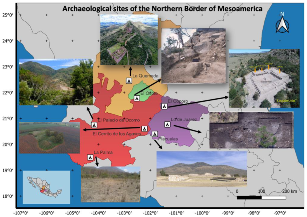
2. Archaeomagnetic Studies along the Northern Frontier of Mesoamerica

2.1. Plazuelas, Guanajuato

The Plazuelas archaeological zone is located in the community of San Juan El Alto Plazuelas to the west of the City of Pénjamo (state of Guanajuato). The main structure of the site is a buildup of quarry buildings, which is material acquired from the same ravine in which the pre-Hispanic settlement is located. Existing archaeological evidence indicates the site’s occupation in the Late Classic or Epiclassic period between 600 AD and 900 AD. However, the age of the foundation of the site is the subject of debate. It could originate from the culture known as the Bajío Tradition brought by people who first populated this pre-Hispanic city. The site was occupied for 300 years and then was destroyed, burned and abandoned [24,25,26,27,28].
An archaeomagnetic investigation of an oriented burned floor was carried out on the extreme east of the archaeological site. It was possible to determine the direction (declination and inclination) and intensity of the remanent magnetization of the burned floor: Dec = 351.5°, Inc = 20.3° with α95 = 2.8° and intensity I = 46.6 ± 1.32 μT. The MATLAB tool developed by [40,41] was implemented using the CALS3k global geomagnetic model of the last three millennia. The combined probability of these three parameters gave the interval from 907 to 997 AD as the most probable age at the time of the last exposure to fire of the analyzed floor, with a confidence of 95% [28].

2.2. El Ocote, Aguascalientes

The El Ocote archaeological site is located 40 km southwest of the city of Aguascalientes near the community of Ocote and is distributed on the top and around the Los Tecuanes hill. Since 2000, reconnaissance studies have been continuously carried out on the site, and it is believed that the site’s development occurred mainly between 650 and 850 AD during the Epiclassic period [35,42]. Consequent systematic excavations revealed a burned floor within the archaeological quadrant I on a surface of approximately 60 m2 at an average depth of 0.60 m with respect to the present-day surface. Six in situ fragments were magnetically oriented to carry out the archaeomagnetic study [35]. The mean directions were obtained for the specimens exhibiting stable, single-component behavior. Subsequently, the dating tool implemented in Matlab [41] was used, considering the SHA.DIF.14K global model of the last fourteen thousand years [35]. The mean direction values obtained were Dec = 351.9°, Inc = 34.8° with α95 = 4.3°. We obtained the age interval 986 to 1088 AD by comparing the mean direction with the reference paleosecular variation curves. The dates obtained by radiometric methods correspond to the early development of the settlement [35]; the archaeomagnetic age corresponds to the late occupation of the site.

2.3. La Palma, Sierra Manantlán, Jalisco

The first archaeological explorations were carried out at the La Palma site within the Archaeology of the Sierra de Manantlán project. The surveys included a large area located to the northeast of the community of Cuzalapa within the valley of the same name on the southern slope (south of the state of Jalisco). The site comprises an area of 2.5 km2 extending from north to south along the Las Tablas stream and is divided into five sectors [36]. In one of the reconnaissance studies, a burnt floor fragment was identified on the southeast corner of structure 1. The floor was characterized by a reddish brown to grayish color with a thickness of 13 cm and reached an approximate area of 60 by 64 cm. Within this stratigraphic unit, a medium-density occupation was inferred judging from the simple ceramic and lithic artifacts without the presence of decorated or diagnostic elements [36]. The mean direction was determined using the Fisher statistics analysis, obtaining an inclination Inc = 32.7°, declination Dec = 344.4° with parameters k = 181 and α95 = 3.8°. This mean direction was compared with the geomagnetic model SHA.DIF.14k (Pavón-Carrasco et al., 2014) [37] obtaining the age interval 986–1150 AD as the most probable age of the last fire exposure of the floor [36].

2.4. La Quemada, Zacatecas

The archaeological site of La Quemada is located in the center of the state of Zacatecas, Mexico, in the municipality of Villanueva south of the city of Zacatecas (the valley of Malpaso). La Quemada is one of the largest settlements within the northern border of Mesoamerica (Jimenez Betts, 2005). The archaeological zone is characterized by traces of strong fires, making it an excellent target for archaeomagnetic studies. Burnt floor samples were collected in the sacrificial plaza and in the Hall of Columns to determine the age ranges of the fall and abandonment of the site that apparently occurred as a religious closure ritual [31].
Two samples, LQ3 and LQ4, corresponded to the north sector of the Hall of Columns; the first corresponds to a burnt, hardened clay floor, and the second sample corresponds to a wall fragment. The Plaza de los Sacrificios, located on the third level of the settlement on the top of the hill, consists of a large plaza with an altar in the center and rooms to the east, south and west and a pyramidal base to the north. Samples LQ1 and LQ2 were taken from this area, corresponding to burned floors [31].
The mean directions for the Plaza de los Sacrificios were obtained using all the specimens corresponding to LQ1 and LQ2 that yielded Inc = 33.67° and Dec = 356.16° with precision parameters k = 323 and α95 = 2.1°. The mean directions for the Hall of Columns were calculated taking into account the eight specimens corresponding to sample LQ3, which yielded Inc = 40.59° and Dec = 345.55°, k = 266 and α95 = 3.4°. Specimens belonging to sample LQ1 corresponding to the Plaza de los Sacrificios provided an average paleointensity of 40.6 ± 2.6 µT, while the specimens belonging to the LQ3 sample corresponding to the Hall of Columns yielded an average paleointensity of 56.5 ± 3.9 µT [31]. We used the SHA.DIF.14K model [40,41] and obtained the age 854–968 AD as the most probable age of the fire of the floors of the Plaza de los Sacrificios (LQ1 and LQ2). We obtained the second probable age interval 722–820 AD, which should not be completely ruled out. For the Hall of Columns (LQ3), the obtained age interval 1018–1163 AD does not coincide with the available radiocarbon age estimates [31].
A second archaeomagnetic study was carried out at La Quemada to place the main Ballgame Court within an absolute chronological framework. On this occasion, two hearths located in rooms associated with the court and a burned cavity on one of the walls were sampled. The Ballgame Court is located on the first level of the settlement at the foot of the hill’s southern slope and consists of a structure 80 m long by 15 m wide with a north–south orientation. Archaeological excavations revealed the presence of three rooms associated with the Ballgame Court divided by masonry walls and associated with three phases of occupation based on overlapping architectural elements [30].
The first areas selected for the archaeomagnetic sampling corresponded to the two hearths that were found within the remnants from the last phase of occupation. Hearth 1 consisted of a rectangular hole on the ground 25 cm long by 15 cm wide and 10 cm deep. The second hearth had a circular shape of 50 cm in diameter and was covered with clay slabs. The third area selected for sampling was located in the outer zone of the Ballgame Court, in which a folded (sunken) wall and secondary deposits of bone remains were found. In the northwest corner carved into the bedrock a hole approximately 30 cm in diameter by 9 cm deep was discovered, which was covered with ash [30].
The mean direction obtained for Hearth 1 was obtained from 13 out of 16 specimens yielding Inc = 34.7°, Dec = 351.3° with α95 = 2.6°. For Hearth 2, the mean direction was obtained from 8 out of 12 specimens yielding Inc = 33.4°, Dec = 358.9° with α95 = 2.7 °. Finally, the mean direction for the burned cavity was obtained from 6 of 11 specimens that yielded Inc = 33.1°, Dec = 354.7° with α95 = 3.2°. Although the average directions of the three structures were very similar, Torreblanca et al. (2020) [30] performed archaeomagnetic dating on each of the structures separately. For Hearth 1, the interval 931–1006 AD was obtained as the most probable age of last heating or use. Hearth 2 sample analyses provided two age intervals: 693–947 AD and 1463–1623 AD. We obtained the age interval 757–980 AD as the most probable age of the last use or heating of the burned cavity [30]. Three of these intervals correspond to the La Quemada occupation phase and its transition to the Ciudadela phase, which represents the last period of activity in the area before the ballcourt was abandoned. However, the interval 1463–1623 AD corresponding to Hearth 2 shows a possible late occupation, which could be interpreted as a reoccupation of the site during the Postclassic period by Zacatecan groups [30].

2.5. El Cóporo, Guanajuato

El Cóporo is an archaeological zone located in the municipality of Ocampo in the northwest of the state of Guanajuato (Sierra de Santa Bárbara) next to the community of San José del Torreón. El Cóporo was created on the hill of the same name whose flat top was used to build the ceremonial area. Both on the slopes and flat parts, there is evidence of multiple ancient constructions. These spaces were made up of architectural ensembles called Llano, Gotas, Montes, Puerto del Aire, Cóporo, Caracol and Pilar [29]. Six sites were located where clear evidence of burned floors could be observed; 15 archaeomagnetic samples were collected there [30]. Since the average directions obtained for each site showed similar values, the probable age intervals of the last burning of the floors were also similar. The obtained age intervals were between the years 820 and 950 AD; for some samples, however, a wide interval from 685 to 1069 AD was obtained [30].
The ceramics and archaeological artifacts correspond to the last stage of occupation, corresponding to the Epiclassic period (600 to 900 AD). During the fall of Teotihuacán in approximately 550 AD, a decline of commercial networks occurred, and a new territorial conformation emerged that led to new regional government centers. During this stage, the Tunal Grande reached its maximum territorial extension, and El Cóporo became the Ocampo Valley’s capital [30]. The abandonment of the Cóporo is the subject of debate; archaeological evidence indicates its decline around the year 900 AD, while recent studies [29] mention a period of reoccupation by the Toltecs around 950 AD. Later, in 1000 AD, Tunal Grande became completely uninhabited by Mesoamerican agricultural groups. The main result of this investigation is the fact that, regardless of the sampling site along the Cóporo, the absolute archaeomagnetic dating intervals are similar, indicating that a large, generalized and widespread fire occurred in a single episode. The presence of burned floors and collapsed buildings supports this hypothesis. However, the possibility of a closing ritual should be considered, since there is no evidence of violent or warlike actions [30].

2.6. Cerrito de Los Agaves, Jalisco

El Cerrito de Los Agaves is located 800 m north of the La Luz community, municipality of Jesús María, Jalisco, in the southeast portion of the region called Los Altos de Jalisco. The central area is made up of a large closed patio (Main Plaza), which has a central altar [43]. The first archaeological excavations at the site were carried out in 2017; the ceramic materials collected in the test pits were not enough to establish a chronological series. However, it was possible to place them in the Epiclassic period when comparing them with materials found at other sites in Los Altos (the central region of Jalisco and the adjacent Bajío region). In 2018, a second archaeological season was carried out in which the central altar and the main mound were studied. A 4 m deep hole was traced and excavated for each structure, which allowed the observation of the tamping of the patio that joins both constructions, partially freeing an access stairway that corresponds to the last construction stage [43].
The mean paleodirections for burned floors were calculated following Fisher’s statistics, obtaining the following results: for the interior floor, an inclination Inc = 36.15° and a declination Dec = 338.23° with parameters k = 257 and α95 = 3.8°; for the floor exterior, an inclination Inc = 34.18° and a declination Dec = 354.35° with parameters k = 210 and α95 = 3.8°. Two archaeomagnetic intervals were obtained: one from 1025 to 1155 AD and one between 914 and 1028 AD [43]. New absolute archaeomagnetic ages show that the main period of occupation of El Cerrito de Los Agaves occurred between the years 600 and 1000 AD. Seven absolute radiocarbon dates were carried out in nearby sites in the region of Los Altos de Jalisco, with ages corresponding to the Bajío Tradition and Tunal Grande Tradition. The available radiocarbon results found are similar to the archaeomagnetic age intervals [43].

2.7. Lo de Juarez, Guanajuato

The Lo de Juárez site is located 6 km north of the city of Irapuato next to the Loma de Juárez community in the state of Guanajuato, Mexico. Structure 1 (a housing unit) and Structure 2 (a living space) were identified during the archaeological excavation. Inside Structure 1, a circular structure with a diameter of 50 cm was excavated, which includes a central hearth made up of basaltic rocks. Ceramic materials and a dozen human burials were also recovered. The work carried out in Structure 2 included the excavation of a cove on the western section at a depth of 1.30 m. A circular alignment was identified with quarried basaltic rocks arranged on a limestone stratum Ten standard paleomagnetic cores were drilled for the hearth and then oriented using both magnetic and solar compasses [38].
The mean directions together with the absolute intensities (for the furnace) were compared to the SHA.DIF.14K geomagnetic model [41] and the interval of 973–1204 AD was obtained as the probable age of the last use of the hearth corresponding to Structure 1.
The age obtained for the hearth of Structure 1 (973–1204 AD) indicates human activity in the area during the period of the depopulation of the northern border (900–1300 AD) in the early Postclassic. On the other hand, the result obtained for the oven of Structure 2 (36 BC–40 AD) represents the oldest absolute dating available in the region of the Guanajuato River basin and therefore suggests that the Lo de Juárez site may correspond to the Interphase (100 BC–1 BC) and Mixtlán (1 AD–250 AD) phases [38].

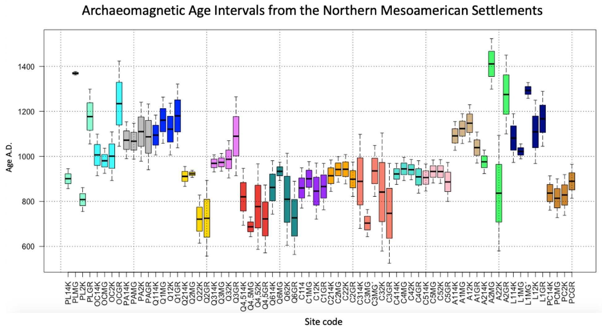
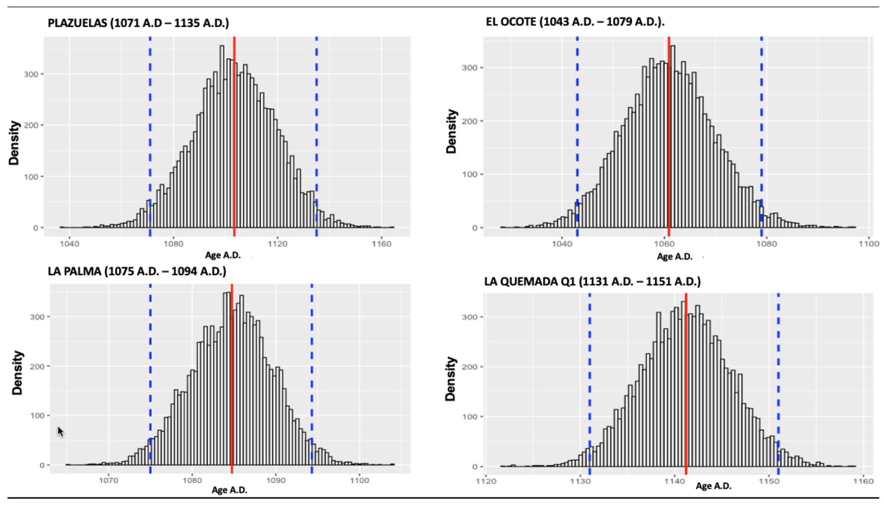
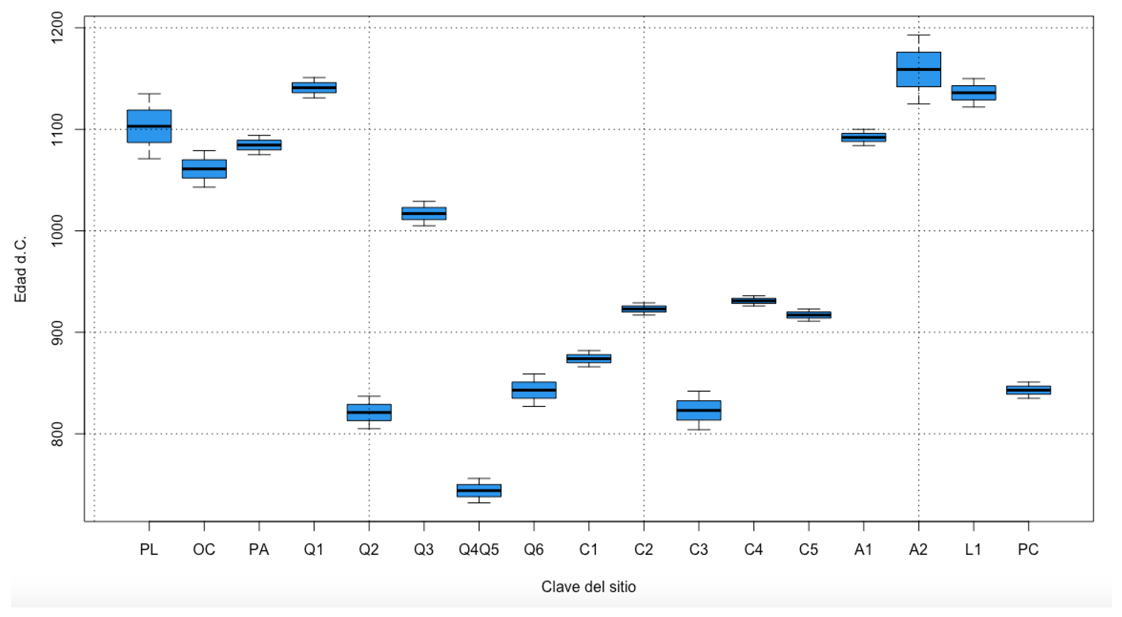
3. Data Analysis and Main Outcomes

A detailed review of archaeomagnetic studies along the northern border of Mesoamerica was carried out. This review allowed the elaboration of a valuable database (Figure 2 and Table 2) that contains the directional data of all the archaeological artifacts and the absolute intensity values. The archaeomagnetic age intervals obtained in our study are listed in Table 1. The global geomagnetic model SHA.DIF.14K [41] was used in eight of the nine studies. In a single case, CALS.3K was employed for the Plazuelas site by Morales et al. (2015) [28]. The SHAWQ2k global geomagnetic model was published recently and is based on a strict selection of available global archaeomagnetic and volcanic data. This new model presents a better description of the geomagnetic field during the last two millennia [44]. In addition, the local paleosecular variation curve (CVPS) by Mahgoub et al. (2019) [45] is based on data from historical lavas and archaeological artifacts exposed to fire in Mesoamerica during the last 46,000 years. The paleosecular variation directional curve for the last three millennia was published by García-Ruíz et al. (2022) [46]; it is based on 82 strictly selected archaeodirections of burned archaeological artifacts and recent volcanic eruptions. Archaeomagnetic dating was carried out for all the sites discussed in this manuscript using the global geomagnetic models SHA.DIF.14K and SHAWQ.2K, as well as the local paleosecular variation curves of Mahgoub et al. (2019) [45] and García-Ruíz et al. (2022) [46] (Table 2).
To obtain the most representative age interval at the statistical level, we applied the bootstrap resampling method first described by Efron (1979) [47]. We created a matrix of 200 theoretical observations for each archaeological artifact and four age intervals obtained using two global geomagnetic models and two local secular variation curves considering the minimum and maximum values. A uniform probability distribution of 40 values was calculated for the intervals derived from the global models and 60 values for the local reference variation curves giving greater weighting to local curves. The uniform distribution is considered the simplest probability model and is characterized by the fact that the cumulative distribution function, taken as a random variable, follows the uniform distribution over the interval (0,1). The uniform distribution is applied to determine powerful functions on randomness tests [48]. The outliners are equally considered between the maximum and minimum values [49]. The bootstrap resampling method does not require prior knowledge of the distribution function of an event and is based on random sampling. The method consists of creating samples of size n that allow the obtainment of a distribution function of the mean values for all generated data. Once the frequency function of the bootstrap mean values has been generated, the standard deviation of the bootstrap mean (Figure 3 and Table 3) and a confidence interval are calculated [50]. In this work, the bootstrap mean value of the age of each dated artifact was calculated along with its standard deviation and α95 confidence interval. Starting from the 200 theoretical observations generated for each artifact, resampling with a replacement of size n = 10,000 was performed. This generated 10,000 samples of 200 random values taken from the original sample, creating a matrix of 200 rows and 10,000 columns. Each column represents a subsample obtained from the original sample of the 200 initial theoretical observations. Subsequently, the mean of each of these subsamples, its standard error and 95% confidence interval were obtained.
Detailed archaeomagnetic surveys of the in situ burned archaeological structures indicate ages that correspond to the end of the Epiclassic and the beginning of the early Postclassic. Table 1 and Table 2 summarize the results of the archaeomagnetic studies carried out in archaeological sites located on the northern border of Mesoamerica (Figure 1). Table 2 presents the results of the new dating approach used in this study. The four archaeomagnetic ages obtained for each archaeological artifact correspond to the two global geomagnetic models and the two local paleosecular variation curves, respectively. Figure 2 shows our study age intervals; each color corresponds to the same artifact. Abbreviated codes 14K, MG, 2K and GR refer to the model or curve used; SHA.DIF.14K and SHAWQ.2K respectively.
Assuming that the archaeomagnetic studies provide the age of the last use or exposure to fire, it is interesting to observe the contemporaneity of most of the ages for the different archaeological zones. All of the dates overlap the interval from 800 to 1100 AD linked to the apparent depopulation of the northern border of Mesoamerica during the early Postclassic.
Judging from the data shown in Figure 2, it is evident that the four data obtained for our study age intervals are very similar. However, there are sites where these age intervals are considerably distant, such as the burned floor of Plazuelas. Although both the global geomagnetic models and the local curves yield probable age intervals with a confidence interval of 95%, in this study, we consider giving greater weight to the age intervals provided by the regional reference paleosecular variation curves. The bootstrap resampling method allowed us to unify the four age intervals obtained from the geomagnetic models and the local curve in a single interval generating 10,000 mean bootstrap values. The frequency histogram for the average age of each archaeological artifact indicates the limits of the confidence interval and its mean. The results of this exercise are reported in Table 3. The histograms were plotted for each archaeological artifact to illustrate the distribution of the bootstrap resampling data (Figure 3).
The most probable optimized age intervals obtained from the different archaeological artifacts (burned floors, ovens, hearths and a burned cavity) from the archaeological sites of the northern border of Mesoamerica provided an age range between 750 and 1100 AD. This matches archaeomagnetic ages obtained in our study and corresponds to the stage of apparent depopulation during the early Postclassic (Figure 4).

4. Discussion

We archaeomagnetically dated several burnt pre-Hispanic floors that correspond to roofed spaces, whether that be rooms or a porch. Other samples were from indoor stoves and ovens. The floors were studied at the sites of La Quemada, Cóporo and Plazuelas. The fires in these sites are likely associated with deliberated incendiary events and ritual abandonment. The definition of the archaeological contexts of abandonment has been extensively discussed in Lopez (2003) [51]: “In strictly archaeological terms, a locality can be considered abandoned when a stratigraphic event covers the interfaces where the social actors work, since otherwise it can continue to be frequented, either by members of the same community or by individuals from other communities”.
The data obtained from the hearths and ovens are on structures created for combustion. Archaeomagnetism allows us to determine the age of the last moment when these areas were exposed to high temperatures. In the case of La Quemada, all three hearths were different; two were built inside the rooms, and a third was a cavity in a rock. The two interior hearths had different shapes and composting materials that could indicate different functions. One of them was composed of four slabs of rhyolite placed vertically and covered with mud, while the other hearth was semi-spherical in shape and made of clay. Different temporalities for the hearths of La Quemada were obtained in our study. The oldest age (hearths Q4 and Q5) is around 744 AD; the youngest (hearth Q3) is around 1017 AD, while the age of the burned cavity (hearth Q6) is around 843 AD.
We also note that La Quemada and Cóporo presented remains of charred beams and scattered roof fragments on the burned floors. The burning corresponds to a layer of the final occupation, since the upper layer shows the gradual deposition of materials accumulated during abandonment that seals the archaeological site. In the case of El Cóporo, a later occupation was detected by nomadic groups that reused the fragmented roof blocks to build a new hearth. This event sits on top of the layers of site occupation and subsequent abandonment. At the same time, a stairway on the north platform of the Plaza del Ocaso was apparently looted during pre-Hispanic times. Traces of fire were located in the Montes and Cóporo complexes, which indicated a generalized fire event that spread throughout the entire settlement. Traces of fire are also evident throughout the site in La Quemada, and the composition of the stratigraphic layers is similar to composition observed in Cóporo. There is also a posterior occupation, as indicated in El Cóporo, where later groups took advantage of the walls to construct simple shelters [15].
At the Plazuelas archaeological site, the remains of a burned floor have also been found, but rather than arguing a widespread fire consumed the city in its last phase of occupation, it is mainly suggested that this indicates the massive destruction of certain buildings [24,25,27]. This phenomenon occurred in the same way at the Cerro Barajas site (state of Guanajuato), where a planned abandonment with rituals of closure was proposed [32,52]. On the other hand, at the sites of El Ocote, La Palma and El Cerrito de Los Agaves, there is evidence of burned floors without signatures of the existence of a ritual abandonment.
Using our new dates, we suggest that there was a widespread fire in La Quemada and Cóporo perhaps linked to the abandonment of the settlement. Although the fire in Plazuelas is not so evident, archeological evidence points to ritual abandonment. A similar situation appears at the site of Cerro Barajas. This abandonment occurred in the transition between the Epiclassic to the early Postclassic, that is, between the years 900 and 1000 AD, which is in accordance with the hypothesis of a stepwise abandonment in the Bajío that started at 900 AD due to drought [24].
Judging from the data presented here, we consider that in La Quemada, Cóporo, Plazuelas and Cerro Barajas there was a differential or gradual abandonment (in Schiffer’s terms, see Schiffer, 1988 and López, 2003) [51,53]. On the other hand, in Lo de Juárez, Ocote, La Palma and Los Agaves, we still lack the reliable data with which to draw conclusions on the past’s incendiary events firmly. It has been pointed out that the Epiclassic was a period of political destabilization with marked militarism [54]. Upon abandoning these Epiclassic sites, the settlers returned to their places of origin where they already had commercial, social or kinship relationships.
The ancient metropolis of Teotihuacán was a reference point for cultural developments in Mesoamerica, and the northern frontier was no exception. Teotihuacán is considered the best-planned and largest pre-Hispanic city in Mesoamerica. One of the causes related to the decline of the Teotihuacán is the so-called “Big Fire”. Previous archaeomagnetic study conducted by Soler-Arechalde et al. (2006) [55] on both burned and unburned stuccos of Teotihuacán provided an age estimate of around 575 AD well before northern border depopulation. However, recent new data [46] suggest that Teotihuacán experienced various fire episodes probably caused and controlled during public acts loaded with symbolic value, such as rituals for the termination of a cycle or those related to the beginning of a new constructive stage. The Teotihuacán state and the small territorial political units of the north center (Querétaro and Tunal Grande) correspond to the periods of initial settlement, colonization, stabilization, population movements and new settlements, territorial reorganization and collapse [56]. The demographic rearrangement and migrations in the Mesoamerican northern border in the 11th century were analyzed by Manzanilla (2005) [8,57]. The migration of groups during this century from the center of Mexico to the north and their subsequent return to their place of origin has been discussed [54,58,59,60,61]. The Mesoamerican northern frontier was a place of mobility and interaction throughout its history [60] between 600 and 900 AD. The history of the origin and abandonment of this territory, however, is still not well reconstructed [62,63,64,65,66,67,68,69].
Mexico’s northern boundary expansion, apogee and subsequent demise have been analyzed in many studies by Pedro Armilla at the site of La Quemada. He proposed that climate changes during the early Postclassic period in combination with social conflicts resulted in decline and abandonment [9,10,11,12]. The climate hypothesis, however, has become very controversial during the last decades. Elliot et al. (2010) [67] carried out phytolith, organic carbon and magnetic susceptibility analyses of a 4000 yr alluvial record of climate and human land use from the Malpaso Valle and argued that early occupation already existed around 500 BC in arid conditions. A similar climate persisted during the Classic period until at least the Postclassic period (see also Somerville, 2015) [65] also hypothesized that anthropogenic landscape degradation influenced the social and geographic changes of the septentrional frontier rather than climatical variation (see also [69]).
On the other hand, the expansion and retraction of the septentrional frontier emerged as the hypothesis for the prolonged bellicose relations with nomadic groups (mainly the Chichimecs) [9,11,13,15]. It is pertinent to note J. Charles Kelley viewed La Quemada as an early Postclassic bastion fortress built to protect against Chichimec intrusions from the Tarascan territory to the south (see review in [70,71]. However, it was detected an extensive Classic period occupation of the area that he called the “American Southwest” (see [71]. In this context, Schöndube [72] regarded West Mexico’s integration into Mesoamerica as a late occurrence dated to the early Postclassic period. Jimenez Betts [70] carried out the most detailed assessment of the septentrional frontier. This author considered that the Mesoamerican world system could not be understood in isolation, and that “Central Mesoamerica had a sequence of rise and fall of state level polities, which during periods of upswing in state development correlated with an increase in the geographical scale of interregional communication and integration. Broadscale interaction interconnected many regions through links with polities of different levels of complexity, in some cases involving core/periphery relations. When state level societies faced disintegration and demise, the long-distance interregional relationships loosened and frayed”. Jimenez Betts [70] suggested that the early Postclassic period in West Mexico had three main events that need attention: (1) the demise of the Epiclassic period inland; (2) the rise of the Aztatlan network along the Pacific Coast, west of the Sierra Madre Occidental; and (3) an unresolved problem concerning the nature of Toltec presence in this region of Mesoamerica. Moreover, an all-inclusive analysis requires considerations that account for the developments in Central Mexico at around 900 AD with the rise of Tula and the decline of Teotihuacán.

5. Conclusions

-
Archaeomagnetic data from the northern border of Mesoamerica were revaluated in light of new global geomagnetic models and local paleosecular variation curves. The studied burned archaeological structures belong to Aguascalientes (El Ocote), Guanajuato (El Cóporo, Lo de Juárez and Plazuelas), Jalisco (Cerro de Los Agaves, La Palma-Sierra Manantlán and El Palacio de Ocomo) and Zacatecas (La Quemada).
-
The in situ archaeological artifacts consisted of burned floors in the vast majority of cases, but also some fire pits and hearths carrying thermoremanent magnetization.
-
Available archaeomagnetic age intervals were recalculated considering the geomagnetic models SHA.DIF.14K [41]. and SHAWQ.2K (Campuzano et al., 2019 [44], as well as the two regional paleosecular variation curves for Mesoamerica by Mahgoub et al. (2019) [45] and García-Ruíz et al. (2022) [46].
-
A bootstrap resampling method was used to obtain an optimal age range for each studied structure. These new absolute chronological intervals indicate that the last fire exposure of the vast majority of analyzed artifacts corresponds to the Mesoamerican early Postclassic.
-
A recent detailed study by Wogau et al. (2019) [69] on the relationship between climatic-environmental changes and their cultural implications on the northern Mesoamerican frontier through high-resolution paleoclimate and paleoenvironmental reconstruction using laminated sediments from La Alberca maar lake (Guanajuato) evidenced two drought events around ~700–790 AD and ~810–880 AD. This supports Armillas’s theory that climate conditions together with potential social conflicts caused the accelerated depopulation of the northern Mesoamerican border in agreement with archaeomagnetic data.

Author Contributions

Conceptualization, A.G.P., A.G. and V.K.; methodology, C.T. and R.G.; formal analysis, M.C. and R.C.; Resources, F.B. and J.M.; writing—original draft preparation, A.G.P., A.G., C.T., V.K., M.C., R.G. and R.C.; writing—review and editing, A.G.P., A.G., C.T., V.K., M.C., R.G. and R.C. All authors have read and agreed to the published version of the manuscript.

Funding

The study was supported by the CONACYT CF 2019-1761 and UNAM-PAPIIT IN101920 projects. V.K. is supported by the Natural Sciences and Engineering Research Council of Canada (NSERC-RGPIN-2019-04780).

Acknowledgments

A.G. is grateful for the support given by UNAM-DGAPA during their sabbatical stay at the University of Alberta.

Conflicts of Interest

The authors declare no conflict of interest.

References

  1. Kirchoff, P. Mesoamérica. Sus límites Geográficos, Composición étnica y Características Culturales. Suplemento de la revista Tlatoani Actas Americanas No.1. Mexico City, 1943; pp. 92–107. Available online: https://revistas.inah.gob.mx/index.php/dimension/article/view/8334 (accessed on 29 September 2022).
  2. Kirchoff, P. Relaciones entre el área de los recolectores cazadores del Norte de México y las áreas circunvecinas. In III Mesa Redonda; El norte de México y el sur de los Estados Unidos, Sociedad Mexicana de Antropología: Mexico City, Mexico, 1944; pp. 255–258. [Google Scholar]
  3. Kirchoff, P. Gatherers and Farmers in the Greater Southwest: A Problem in Classification. In American Anthropologist; Wiley: New York, NY, USA, 1954; pp. 529–550. [Google Scholar]
  4. Mendizábal, M.O. Colonización del Oriente de Jalisco y Zacatecas. In III Mesa Redonda; El norte de México y el sur de los Estados Unidos, Sociedad Mexicana de Antropología: Mexico City, Mexico, 1944; pp. 40–49. [Google Scholar]
  5. Jiménez, W. Tribus e idiomas del norte de México. In El Norte de México y el Sur de los Estados Unidos; 1944; Available online: https://www.scielo.org.mx/scielo.php?script=sci_arttext&pid=S1607-050X2016000100172 (accessed on 29 September 2022).
  6. Margain, C.R. Zonas arqueológicas de Querétaro, Guanajuato, Aguascalientes y Zacatecas. In El Norte de México y el Sur de los Estados Unidos. III Mesa Redonda El Norte de México y el sur de los Estados Unidos; Sociedad Mexicana de Antropología: Mexico City, Mexico, 1944; pp. 145–148. [Google Scholar]
  7. Braniff, B. Secuencia arqueológica en Guanajuato y la cuenca de México: Intento de correlación. In Teotihuacán, XI Mesa Redonda de la Sociedad Mexicana de Antropología; La Sociedad: Mexico City, Mexico, 1972; pp. 273–323. [Google Scholar]
  8. Manzanilla, L. Reacomodos Demográficos del Clásico al Posclásico en el Centro de México; Instituto de Investigaciones Antropológicas UNAM: Mexico City, Mexico, 2005. [Google Scholar]
  9. Armillas, P. Condiciones ambientales y movimiento de pueblos en la frontera septentrional de Mesoamérica. In Homenaje a Fernando Miranda. Publicaciones del Seminario de Estudios Americanistas y del Seminario de Antropología Americana; Universdad de Madríd y Sevilla: Sevilla, España, 1964; pp. 62–82. [Google Scholar]
  10. Armillas, P. The Northern Mesoamérica. In Prehistoric Man in the New Word; Jennings, J., Norbeck, E., Eds.; The University of Chicago Press: Chicago, IL, USA, 1964; pp. 291–329. [Google Scholar]
  11. Armillas, P. The arid frontier of mexican civilization. In Transaction the New York Academy of Sciences; Series II; Wiley: New York, NY, USA, 1969; Volume 31, pp. 697–704. [Google Scholar]
  12. Braniff, B. Oscilación de la frontera Septentrional Mesoamericana. In The Archaelogy of West México; Bell, B., Ed.; Sociedad de Estudios Avanzados de Occidente de México: Ajijic, Mexico, 1974; pp. 40–50. [Google Scholar]
  13. Braniff, B. Oscilación de la frontera Septentrional Mesoamericana: Un nuevo ensayo. In Arqueología No. 1, Dirección de Arqueología; INAH: Mexico City, Mexico, 1989; pp. 99–114. [Google Scholar]
  14. Castañeda, B.; Crespo, A.M.; Flores, L.M. Tunal Grande: Frontera de equilibrio para Mesoamérica. In Boletín de Antropología, Nueva Época No. 34; INAH: Mexico City, Mexico, 1991; pp. 22–29. [Google Scholar]
  15. Hers, M.A. Los Toltecas en Tierras Chichimecas; IIE-UNAM: Mexico City, Mexico, 1989. [Google Scholar]
  16. Hers, M.A. Colonización Mesoamericana y Patrón de Asentamiento en la Sierra Madre Occidental. In Origen y Desarrollo del Occidente de México; Boehm de Lameiras, B., Weigand, P.C., Eds.; Librería COLMICH: Zamora, Mexico, 1992; pp. 103–136. [Google Scholar]
  17. Kelley, J.C. Archaeology of the Northern Frontier Zacatecas and Durango. In Handbook of Middle American Indians; Wauchope, E., Ed.; University of Texas Press: Austin, TX, USA, 1971; Volume 11, pp. 768–801. [Google Scholar]
  18. Kelley, J.C. Speculation on the culture history of Northwest Mesoamerica. In The Archaelogy of West México; Bell, B., Ed.; Sociedad de Estudios Avanzados de Occidente de México: Ajijic, Mexico, 1974; pp. 19–39. [Google Scholar]
  19. Kelley, J.C. Alta Vista: Outpost of Mesoamerica Empire on the Tropic of Cancer. In Las Fronteras de Mesoamérica; XIV Mesa Redonda de la Sociedad Mexicana de Antropología: Mexico City, Mexico, 1976; pp. 21–40. [Google Scholar]
  20. Weigand, P.C. La Prehistoria en el Estado de Zacatecas. Anuario de Historia; Departamento de Investigaciones Histó-ricas, Universidad Autónoma de Zacatecas: Zacatecas, Mexico, 1978; pp. 203–248. [Google Scholar]
  21. Brambila, R.; Castañeda, C.; Crespo, A.; Duran, T.; Flores, L.; Saint-Charles, J.C. Problemas de las sociedades prehispánicas del Centro Occidente de México. Resumen. In Primear Reunión Sobre Sociedades Prehispánicas en el Centro Occidente de México, Memoria; Cuaderno de Trabajo No. 1; INAH: Mexico City, Mexico, 1988; pp. 11–22. [Google Scholar]
  22. Castañeda, C.; Crespo, A.M.; Contreras, J.A.; Saint Charles, J.C.; Durán, T.; Flores, L.M. Interpretación de la Historia del Asentamiento en Guanajuato. In Primera Reunión Sobre Sociedades Prehispánicas en el Centro Occidente de México. Memorias. Cuaderno de Trabajo; No. 1; INAH: Mexico City, Mexico, 1988; pp. 322–356. [Google Scholar]
  23. Nalda, E. Proposiciones Para un Estudio del Proceso de Contracción de Mesoamérica. In Las Fronteras de Mesoamérica; XIV Mesa Redonda de la Sociedad Mexicana de Antropología, Tomo I: Villahermosa, Mexico, 1976; pp. 51–60. [Google Scholar]
  24. Castañeda, C.; Quiroz, J. Plazuelas y la tradición Bajío. In Tradiciones arqueológicas. Efraín Cárdenas García Coordinador General; El Colegio de Michoacán, Gobierno de Estado de Michoacán: Mexico City, Mexico, 2004. [Google Scholar]
  25. Castañeda, C.; Plazuelas, G. Zona Arqueológicas en Guanajuato. Cuatro Casos: Plazuelas, Cañada de la Virgen, Peralta y El Cóporo; IEC, INAH: Guanajuato, Mexico, 2007; pp. 21–67. [Google Scholar]
  26. Castañeda, C. Los movimientos de poblaciones en el suroeste de Guanajuato. In Migraciones e Interacciones en el Septentrión Mesoamericano; García, E.C., Ed.; El Colegio de Michoacán: Zamora, Mexico, 2017; pp. 119–138. [Google Scholar]
  27. Aramoni, M. El Mundo Prehispánico de Guanajuato. Plazuelas. Lugar de la Serpiente de Fuego; INAH: Mexico City, Mexico, 2014. [Google Scholar]
  28. Morales, J.; Castañeda, C.; Cárdenas, E.; Goguitchaichvili, A. New evidence of the date of abandonment of the plazuelas archaeological site in Guanajuato, Mexico through archaeomagnetic dating of a burned floor. Arqueol. Iberoam. 2015, 28, 40–45. [Google Scholar]
  29. Torreblanca, C. El Cóporo. Una Antigua Ciudad Bajo la Nopaler; IEC INAH: Guanajuato, Mexico, 2015. [Google Scholar]
  30. García-Pimentel, A.; Goguitchaichvili, A.; Torreblanca, C.; Cejudo, R.; Kravchinsky, V.; García, R.; Morales, J.; Cervantes, M. The memory of fire in El Cóporo (Northern Mesoamerica): Apogee and abandonment. J. Archaeol. Sci. Rep. 2020, 30, 102274. [Google Scholar] [CrossRef]
  31. López-Delgado, V.; Goguitchaichvili, A.; Torreblanca, C.; Cejudo, R.; Jimenez, P.; Morales, J.; Soler, A.M. La Quemada: Decline and abandonment in two stages on the classic period northern frontier of Mesoamerica. J. Archaeol. Sci. Rep. 2019, 24, 574–581. [Google Scholar] [CrossRef]
  32. Pereira, G.; Migneon, G.; Michelet, D. Transformaciones demográficas y culturales en el centro norte de México en vís-peras del posclásico: Los sitios del Cerro Barajas (Suroeste de Guanajuato). In Reacomodos Demográficos del Clásico al Posclásico en el Centro de México; Manzanilla, L., Ed.; IIA-UNAM: Mexico City, Mexico, 2005; pp. 123–136. [Google Scholar]
  33. Carrancho, A.; Gogichaishvili, A.; Kapper, L.; Morales, J.; Soler Arechalde, A.M.; Tema, E. Geomagnetic applications in archeology: State of the art and recent advances. In New Developments in Paleomagnetism Research; Nova Science Publishers, Inc.: New York, NY, USA, 2015; pp. 53–98. [Google Scholar]
  34. Brown, M.C.; Hervé, G.; Korte, M.; Genevey, A. Global archaeomagnetic data: The state of the art and future challenges. Phys. Earth Planet. Inter. 2021, 318, 106766. [Google Scholar] [CrossRef]
  35. Cejudo, R.; García-Ruiz, R. Intervención arqueomagnética en El Ocote (Aguascalientes, México): Implicaciones cronológicas absolutas. Arqueol. Iberoam. 2019, 44, 3–9. [Google Scholar] [CrossRef]
  36. Pomedio, C.; López, V.; Goguitchaichvili, A.; Cejudo, R.; Morales, J.; Soler-Arechalde, A.; Cervantes-Solano, M.; García, R. Estudio arqueomagnético del Piso Quemado en la Palma, Valle de Cuzalapa, Sierra de Manantlán (Jalisco). Boletín Soc. Geológica Mex. 2021, 74, 1. [Google Scholar] [CrossRef]
  37. Esparza, R.; López, V.; Cejudo, R.; Goguitchaichvili, A.; Yoshida, T.; Rétiz, M.; Rodríguez, F.; Cervantes-Solano, M.; Morales, J.; Bautista, F. Estudio petromagnético y arqueomagnético del sitio El Cerrito de Los Agaves en la parte Suroriental de los Altos de Jalisco. Boletín Soc. Geológica Mex. 2020, 73, A210121.1–A210121.12. [Google Scholar] [CrossRef]
  38. López-Delgado, V.; Rodríguez, L.; Goguitchaichvili, A.; Morales, I.; Cejudo, R.; Morales, J.; Soler, A.M.; Bautista, F.; García, R. De Chupícuaro al despoblamiento de la frontera septentrional. Evidencia arqueomagnética del sitio Lo de Juárez, Guanajuato, México. Boletín Soc. Geológica Mex. 2021, 73, A050121. [Google Scholar] [CrossRef]
  39. Morales, I. “Lo de Juárez”, una unidad habitacional prehispánica en la cuenca del río Guanajuato. Aproximación a la dinámica doméstica y sociopolítica de los habitantes del Irapuato, prehispánico. Bachelor’s Thesis, Unidad Académica de Antropología de la UAZ, Zacatecas, Mexico, 2020. [Google Scholar]
  40. Pavón-Carrasco, F.J.; Rodríguez-González, J.; Osete, M.L.; Torta, J.M. A matlab tool for archaeomagnetic dating. J. Archaeol. Sci. 2011, 38, 408–419. [Google Scholar] [CrossRef]
  41. Pavón-Carrasco, F.J.; Osete, M.L.; Torta, J.M.; De Santis, A. A geomagnetic field model for the Holocene based on archaeomagnetic and lava flow data. Earth Planet. Sci. Lett. 2014, 388, 98–109. [Google Scholar] [CrossRef]
  42. Pelz, A.M.; Jiménez, J. Arqueología en Aguascalientes. El Ocote. In La reinvención de la Memoria. Ensayos para una Historia de Aguascalientes; Tomo, I., González Esparza, V.M., Eds.; Col. Nueva Historia; Instituto de Cultura de Aguascalientes: Aguascalientes, Mexico, 2007; pp. 83–107. [Google Scholar]
  43. Esparza, C.; Goguitchaichvili, A.; López, V.; Cejudo, R.; Morales, J.; Bautista, F.; Kravchinsky, V.; Garcia, R. Ball court in la quemada, northern Mesoamerica: Absolute chronological contributions through the archeomagnetic study of associated fire pits. J. Archaeol. Sci. Rep. 2020, 33, 102558. [Google Scholar] [CrossRef]
  44. Campuzano, S.A.; Gómez-Paccard, M.; Pavón-Carrasco, F.J.; Osete, M.L. Emergence and evolution of the South Atlantic Anomaly revealed by the new paleomagnetic reconstruction SHAWQ2k. Earth Planet. Sci. Lett. 2019, 512, 17–26. [Google Scholar] [CrossRef]
  45. Mahgoub, A.N.; Juárez-Arriaga, E.; Böhnel, H.; Manzanilla, L.R.; Cyphers, A. Refined 3600 years palaeointensity curve for Mexico. Phys. Earth Planet. Inter. 2019, 296, 106328. [Google Scholar] [CrossRef]
  46. García-Ruiz, R.; Goguitchaichvili, A.; Pavón-Carrasco, F.J.; Soler, A.M.; Pérez-Rodríguez, N.; Osete, M.L.; Kravchinsky, V. Fluctuations of magnetic inclination and declination in Mexico during the last three millennia. Quat. Geochronol. 2022, 71, 101309. [Google Scholar] [CrossRef]
  47. Efron, B. Computers and the theory of statistics: Thinking the unthinkable. SIAM Rev. 1979, 21, 460–480. [Google Scholar] [CrossRef]
  48. Jayakumar, K.; Sankaran, K.K. On a generalization of uniform distribution and its properties. Statistica 2016, 76, 83–91. [Google Scholar]
  49. González-Hernández, I.J.; Simón-Marmolejo, I.; Granillo-Macías, R.; Santana-Robles, F.; Rondero-Guerrero, C.; Soto-Campos, C.A. Simulación de la distribución uniforme generalizada. Ingenio Concienc. Boletín Científico Esc. Super. Ciudad. Sahagún 2020, 7, 23–28. [Google Scholar] [CrossRef]
  50. Hernández-Abreu, E.; Martínez-Pérez, M. El Método Bootstrap en la Estimación de Incertidumbres. In Boletín Científico Técnico Inimet, Núm. 1; Instituto Nacional de Investigaciones en Metrología Ciudad de La Habana: la Habana, Cuba, 2012; pp. 8–16. [Google Scholar]
  51. López, F. Los procesos de abandono. Lo blanco y lo negro de la interpretación arqueológica. In Trace. Abandono de Asentamientos Prehispánicos Hispánicos, Junio; No. 43; CEMCA: Mexico City, Mexico, 2003; pp. 56–69. [Google Scholar]
  52. Gérald, M. Abandonos Planificados, Rituales de Vasijas Matadas o de Clausura y Ocupaciones Posteriores. In Trace. Abandono de Asentamientos Prehispánicos Hispánicos, Junio, No. 43; CEMCA: Mexico City, Mexico, 2003; pp. 97–115. [Google Scholar]
  53. Schiffer, M.B. Existe una “premisa de pompeya” en arqueología? Boletín Antropol. Am. 1988, 18, 5–31. [Google Scholar]
  54. Nelson, B.; Crider, D. Posibles pasajes migratorios en el norte de México y el suroeste de los Estados Unidos durante el Epiclásico y el Posclásico. In Reacomodos Demográficos del Clásico al Posclásico en el Centro de México; Manzanilla, L., Ed.; IIA-UNAM: Mexico City, Mexico, 2005; pp. 75–102. [Google Scholar]
  55. Soler-Arechalde, A.M.; Sánchez, F.; Rodriguez, M.; Caballero-Miranda, C.; Goguitchaishvili, A.; Urrutia-Fucugauchi, J.; Manzanilla, L.; Tarling, D.H. Archaeomagnetic investigation of oriented pre-Columbian lime-plasters from Teotihuacan, Mesoamerica. Earth Planets Space 2006, 58, 1433–1439. [Google Scholar] [CrossRef] [Green Version]
  56. Crespo, A.M. La Expansión de la Frontera Norte (y la Cronología Oficial Para Teotihuacán). In Los Ritmos de Cambio en Teotihuacán: Reflexiones y Discusiones de su Cronología; Brambila, R., Cabrera, C., Eds.; INAH: Mexico City, Mexico, 1998; pp. 323–334. [Google Scholar]
  57. Cárdenas, G.E. Migraciones e Interacciones en el Septentrión Mesoamericano; El Colegio de Michoacán: Mexico City, Mexico, 2017. [Google Scholar]
  58. Hers, M.A. Imágenes Norteñas de los Guerreros Toltecas-Chichimecas. In Reacomodos Demográficos del Clásico al Posclásico en el Centro de México; Manzanilla, L., Ed.; IIA-UNAM: Mexico City, Mexico, 2005; pp. 11–56. [Google Scholar]
  59. Carot, P. Reacomodos Demográficos del Clásico al Posclásico en Michoacán: El Retorno de los que se Fueron. In Reacomodos Demográficos del Clásico al Posclásico en el Centro de México; Manzanilla, L., Ed.; IIA-UNAM: Mexico City, Mexico, 2005; pp. 103–121. [Google Scholar]
  60. Brambila, P.; Crespo, A. Desplazamientos de Poblaciones yc Creación de Territorios en el Bajío. In Reacomodos Demográficos del Clásico al Posclásico en el Centro de México; Manzanilla, L., Ed.; IIA-UNAM: Mexico City, Mexico, 2005; pp. 155–173. [Google Scholar]
  61. Carot, P.; Hers, M.A. De Teotihuacán al Cañón de Chaco: Nueva Perspectiva Sobre las Relaciones Entre Mesoamérica y El Suroeste de los Estados Unidos. In Anales del Instituto de Investigaciones Estéticas; Número 98; UNAM: Mexico City, Mexico, 2011; Volume XXXIII, pp. 5–53. [Google Scholar]
  62. Brown, R.B. Paleoecología y Arqueología en la Frontera Norte de Mesoamérica: Un análisis. Cuaderno de Trabajo No. 13, Dirección de Arqueología; INAH: Mexico City, Mexico, 1991. [Google Scholar]
  63. Park, J.J. Holocene environmental change and human impact in Hoya Rincon de Parangueo, Guanajuato, Mexico. Korean J. Ecol. 2005, 28, 245–254. [Google Scholar] [CrossRef] [Green Version]
  64. Elliott, M. Classic Period Wood Use at Monumental Center in Northwestern Mesoamerica. In Archaeological Charcoal: Natural or Human Impact on the Vegetation; SAGVNTVW EXTRA-11; 2011; pp. 117–118. Available online: https://www.sapac.es/charcoal/saguntum/extra11/se11_117.pdf (accessed on 29 September 2022).
  65. Elliott, M. An anthracological approach to understanding Late Classic period cultural collapse in Mesoamerica’s northwestern frontier. In Wood and Charcoal: Evidence for Human and Natural History, 13; Badal, E., Carrión, Y., Macias, M., Eds.; Maria Ntinou Departament de Prehistòria i d’Arqueologia, Universitat de Valencia: Valencia, Spain, 2012; pp. 217–225. [Google Scholar]
  66. Elliott, M.; Nelson, B.; Fisher, C. Vinculando la Historia de Asentamientos Humanos con la Evolución Socio-Ecológica del Paisaje en Mesoamérica Septentrional: Una Perspectiva Desde el sur de Zacatecas. In Espaciotiempo: La Arqueología en el Norte de México, No. 3; Coordinación de Ciencias Sociales y Humanidades de la UASLP: San Luis Potosí, Mexico, 2008; pp. 107–122. [Google Scholar]
  67. Elliott, M.; Fisher, C.T.; Nelson, B.A.; Garza, R.S.M.; Collins, S.K.; Pearsall, D.M. Climate, agriculture, and cycles of human occupation over the last 4000 yr in southern Zacatecas, Mexico. Quat. Res. 2010, 74, 26–35. [Google Scholar] [CrossRef]
  68. Dominguez, G.; Castro, V. Cambios climáticos y sus efectos en el ambiente durante el Holoceno en el Bajío. In Migraciones e Integraciones en el Septentrión Mesoamericano; García, E.C., Ed.; El Colegio de Michoacán: Zamora, Mexico, 2017; pp. 27–40. [Google Scholar]
  69. Wogau Kurt, H.; Arz, H.; Böhnel, H.; Nowaczyk, N.; Jungjae, P. High resolution paleoclimate and paleoenvironmental reconstruction in the Northern Mesoamerican Frontier for Prehistory to Historical times. Quat. Sci. Rev. 2019, 226, 1–20. [Google Scholar]
  70. Jimenez Betts, P. Orienting West Mexico, The Mesoamerican World System 200–1200 CE. Doctoral Thesis, Department of Historical Studies, University of Gothenburg, Gothenburg, Sweden, 2018; p. 268. [Google Scholar]
  71. Jimenez Betts, P. Llegaron, se pelearon y se fueron: Los modelos, abusos, y alternativas de la migración en la arqueología del norte de Mesoamérica. In Reacomodos demográicos del Clásico al Posclásico en el Centro de Mexico; Manzanilla, L., Ed.; IIA/UNAM: Mexico City, Mexico, 2015; pp. 57–74. [Google Scholar]
  72. Schöndube, B.O. Epoca prehispánica. In Historia de Jalisco: Vol. 1, Desde los Tiempos Prehistóricos Hasta ines del Siglo XVII; Muriá, J.M., Ed.; Gobierno de Jalisco: Guadalajara, Mexico, 1980; pp. 113–257. [Google Scholar]
Figure 1. Location of the archaeological sites mentioned in the text.
Land 11 02103 g001
Figure 2. Possible archaeomagnetic age intervals computed using global geomagnetic models and regional reference paleosecular variation curves (see text for more details).
Land 11 02103 g002
Figure 3. Histograms of the age intervals obtained for the burned floors of Plazuelas, El Ocote, La Palma and La Quemada by bootstrap resampling method; the red line indicates the mean age of the dated archaeological artifact, while the blue lines delimit the 95% confidence interval.
Land 11 02103 g003
Figure 4. Age intervals for archaeological artifacts from sites located on the northern border of Mesoamerica calculated using the bootstrap method.
Land 11 02103 g004
Table 1. Available archaeomagnetic data for the archaeological sites belonging to the northern frontier of Mesoamerica indicating their location, possible age intervals and the geomagnetic model used.
AuthorArchaeological SiteLocationInclination (°)Declination (°)Intensityα95Dating Interval Obtained (A.D.)
Morales et al., 2015 [28]PlazuelasGuanajuato20.3351.546.6 ± 1.32 μT2.8°907–997
Cejudo et al., 2019 [35]El OcoteAguascalientes34.8351.9 4.3°916–1088
1205–1335
Pomedio et al., 2022 [36]La PalmaJalisco32.7344.4 3.8°986–1150
López et al., 2019 [31]La QuemadaZacatecas 40.59345.5556.5 ± 3.9 μT3.4°1018–1163
33.67356.1640.6 ± 2.6 μT2.1°722–820
854–968
Torreblanca et al., 2020 [30] La QuemadaZacatecas 34.7351.3 2.6°931–1006
33.4358.9 2.7°693–947
1463–1526
1571–1623
33.1354.7 3.2°757–980
García-Pimentel et al., 2020 [30]El CóporoGuanajuato25.7353.8 4.2°769–946
27.4351.4 3.9°840–977
30.5353.2 8.7°685–1069
1231–1332
1403–1538
1565–1645
24.3349.3 3.7°863–967
26.4352.4 2.8°827–963
Esparza et al., 2022 [37]El Cerrito de Los AgavesJalisco36.15338.23 3.8°1025–1155
34.18354.35 3.8°914–1028
1213–1501
1617–1655
López et al., 2021 [38]Lo de JuárezGuanajuato35.05348.66 1.8973–1204
Morales et al., 2020 [39]El Palacio de OcomoJalisco21.6357 3.1°759–915
Table 2. Reappraisal of archaeomagnetic age intervals using global geomagnetic models and local reference curves (see text for more details).
Archaeological SiteSite CodeLocationDated MaterialSHA.DIF.14k (14K) (A.D.)Mahgoub et al., 2019 [45]. (MG) (A.D.)SHAWQ.2K (2K) (A.D.)García-Ruíz et al., 2022 [46]. (GR). (A.D.)
PlazuelasPLGuanajuatoBurned floor857–945 1362–1377 755–8611055–1299
El OcoteOCAguascalientesBurned floor914–1099
1193–1337
925–1036
1279–1463
893–11091045–1424
La PalmaPAJaliscoBurned floor990–1154 988–1147 979–1241941–1233
La QuemadaQ1Zacatecas Burned floor1006–1183 1058–1264 1006–12361038–1322
Q2 Burned floor704–825
867–955
907–938
1388–1506
614–828557–893
La QuemadaQ3Zacatecas Fire pit931–1007 934–1013
1307–1411
904–1070 914–1265
Q4, Q5 Fire pit694–947
1464–1524
1572–1624
643–731
1430–1541
587–967
1572–1692
571–873
Q6 Burned cavity743–981893–974
1350–1497
605–1014 564–890
1178–1295
El CóporoC1GuanajuatoBurned floor770–949 824–977 721–970 763–969
C2 Burned floor844–984 885–999 878–1008 822–975
C3 Burned floor680–1098
1201–1348
1389–1546
1559–1651
643–764
822–1049
1276–1542
579–1104 525–969
1016–1434
C4 Burned floor875–969 893–996730–846
896–986
837–981
C5 Burned floor846–966 882–984880–985800–973
El Cerrito de Los AgavesA1JaliscoInterior burned floor1027–1155 1057–11901065–1230 970–1108
A2 Exterior burned floor924–1028
1214–1492
1623–1655
1299–1523580–1093
1189–1487
427–738
1100–1450
Lo de JuárezL1GuanajuatoFire pit973–1190 989–1055
1258–1328
968–12501045–1289
El Palacio de OcomoPCJaliscoBurned floor761–913 728–900738–919 814–965
Table 3. Age intervals retrieved applying bootstrap method (please see text for more details).
Archaeological Site Site CodeLocationMean (A.D.)Standard Deviation (Years)95% Age Confidence Interval (A.D.)
PlazuelasPLGuanajuato1103321071–1135
El OcoteOCAguascalientes1061181043–1079
La PalmaPAJalisco10859.61075–1094
La QuemadaQ1Zacatecas 1141101131–1151
Q2 82116805–837
La QuemadaQ3Zacatecas 1017121005–1029
Q4,Q5 74412732–756
Q6 84316827–859
El CóporoC1Guanajuato8748866–882
C2 9236917–929
C3 82319804–842
C4 9315.2926–936
C5 9176911–923
El Cerrito de Los AgavesA1Jalisco109281084–1100
A2 1159341125–1193
Lo de JuárezL1Guanajuato1136141122–1150
El Palacio de OcomoPCJalisco8438835–851
Publisher’s Note: MDPI stays neutral with regard to jurisdictional claims in published maps and institutional affiliations.

