Article

Spatial Patterns and Intensity of Land Abandonment Drive Wildfire Hazard and Likelihood in Mediterranean Agropastoral Areas

1
National Research Council of Italy, Institute of BioEconomy (CNR IBE), 07100 Sassari, Italy
2
Faculty of Agriculture and Natural Resources, University of Mohaghegh Ardabili, Ardabil 56199-11367, Iran
3
Department of Agricultural and Forest Engineering, University of Lleida, 25003 Lleida, Spain
*
Author to whom correspondence should be addressed.
Land 2022, 11(11), 1942; https://doi.org/10.3390/land11111942
Submission received: 4 October 2022 / Revised: 26 October 2022 / Accepted: 28 October 2022 / Published: 31 October 2022
(This article belongs to the Special Issue Feature Papers for Landscape Ecology Section)

Abstract

:
In Mediterranean agropastoral areas, land abandonment is a key driver of wildfire risk as fuel load and continuity increase. To gain insights into the potential impacts of land abandonment on wildfire risk in fire-prone areas, a fire-spread modeling approach to evaluate the variations in wildfire potential induced by different spatial patterns and percentages of land abandonment was applied. The study was carried out in a 1200 km2 agropastoral area located in north-western Sardinia (Italy) mostly covered by herbaceous fuels. We compared nine land abandonment scenarios, which consisted of the control conditions (NA) and eight scenarios obtained by combining four intensity levels (10, 20, 30, 40%) and two spatial patterns of agropastoral land abandonment. The abandonment scenarios hypothesized a variation in dead fuel load and fuel depth within abandoned polygons with respect to the control conditions. For each abandonment scenario, wildfire hazard and likelihood at the landscape scale was assessed by simulating over 17,000 wildfire seasons using the minimum travel time (MTT) fire spread algorithm. Wildfire simulations replicated the weather conditions associated with the largest fires observed in the study area and were run at 40 m resolution, consistent with the input files. Our results highlighted that growing amounts of land abandonment substantially increased burn probability, high flame length probability and fire size at the landscape level. Considering a given percentage of abandonment, the two spatial patterns of abandonment generated spatial variations in wildfire hazard and likelihood, but at the landscape scale the average values were not significantly different. The average annual area burned increased from about 2400 ha of the control conditions to about 3100 ha with 40% land abandonment. The findings of this work demonstrate that a progressive abandonment of agropastoral lands can lead to severe modifications in potential wildfire spread and behavior in Mediterranean areas, thus promoting the likelihood of large and fast-spreading events. Wildfire spread modeling approaches allow us to estimate the potential risks posed by future wildfires to rural communities, ecosystems and anthropic values in the context of land abandonment, and to adopt and optimize smart prevention and planning strategies to mitigate these threats.

1. Introduction

In Mediterranean areas, wildfires are an important disturbance agent and cause significant losses to ecosystems, farms, anthropic values and, sometimes, even human lives [1,2,3,4,5]. During the 2011–2020 period, south-western Europe (Italy, France, Spain, Portugal, and Greece) experienced an average of about 38,000 fire ignitions per year with an annual burned area close to 320,000 hectares [6]. However, the 2017 wildfire season was the worst ever observed in the above countries, with about 0.9 million hectares burned [6]. More recently the European Forest Fire Information System EFFIS highlighted that 2021 was the second-worst wildfire season (following 2017) in the European Union since 2000 [7]; the current 2022 wildfire season was also very complex in several EU Countries (e.g., Spain; France). These recent severe wildfire seasons warn against the potential increase in dangerous environmental conditions able to sustain the occurrence of devastating wildfires or even megafires [8,9,10] which are associated with an overall increase in fire danger conditions in the Mediterranean Basin [11,12,13].
Several works analyzed the role played by the complex spatial and temporal relationships among multiple physical, biological, and anthropogenic drivers on the wildland fire regime and spread [14,15,16,17]. Among these factors, the increasing fuel accumulation and continuity at the landscape scale, mostly related to land abandonment processes and fire exclusion policies, in combination with the increased frequency and length of adverse weather conditions (i.e., heat waves, dryness, strong winds), were evidenced as main drivers for current and likely future variations in the wildfire regime and losses in Europe [18,19,20,21,22,23,24].
Regarding land abandonment, Schuh et al. [25] evidenced that around 30% (circa 56 million ha) of agricultural areas in the EU are under moderate or high risk of land abandonment, and that remote areas, mountains, islands, coastal and sparsely populated areas are particularly affected by this phenomenon. The island of Sardinia (Italy), together with other Mediterranean islands, Northern Portugal, and Southern France, was identified as an EU hot-spot area in terms of both incidence of land abandonment and decrease in utilized agricultural areas [25]. Indeed, the abandonment of agricultural and livestock practices together with the loss of agro-silvopastoral farms are of particular concern in a number of areas in Sardinia, where they are linked to a series of negative cascading effects including the loss of economies in remote rural areas, depopulation, denatality, desertification of the socio-economic and productive fabric, and rewilding of agropastoral areas [26,27,28,29]. This is particularly evident in extensive agropastoral farms and marginal lands, which generally cover areas where the intensification of agricultural and livestock production is often limited by environmental factors (e.g., topography, stoniness, soil, lack of irrigation water) and land size and property constraints (i.e., myriad of small and dispersed plots owned by private owners, with several parcels being less than two hectares) [28,30,31]. The ecological succession after abandonment often allows the increase in biodiversity and favors interactions between species [32] but is on the other hand responsible for the increase in continuity and load of flammable fuels, which in turn can promote the potential occurrence of larger and more intense wildfires [33,34,35,36,37,38]. In this sense, grazing and agricultural activities can represent valuable means to obtain well-managed land use mosaics, which are in fact able to reduce wildfire spread and intensity and can increase fire-fighting effectiveness [39,40,41].
Despite uncertainties and limitations concerning the application of wildfire spread models to inform risk reduction strategies and optimize landscape management programs, many projects and works highlighted the crucial role of funding and implementing this type of prevention activities [42,43,44,45,46,47,48]. In this sense, policy resolutions and development of investment strategies could benefit from realistic quantifications of the effects of fuel change scenarios on wildfire spread modeling outputs such as burn probability, fire intensity and size, and fire transmission towards neighboring land tenures or values after ignition [49,50,51,52]. Assessing the impact of land abandonment in terms of wildfire risk has been addressed in several studies [24,35,53]; however, at the landscape scale, only a very limited number of works estimated and quantified the potential impacts of agropastoral land abandonment and fuel build-up on wildfire propagation and behavior in fire-prone Mediterranean areas [54,55].
In this study, we used landscape wildfire simulations based on the minimum travel time (MTT) algorithm [56]. The MTT algorithm is a compact fire simulation algorithm that makes it computationally feasible to simulate thousands of fires over large areas, is parallelized for multi-threaded processing and imbedded in a number of research and modeling applications, and is widely used in Mediterranean areas to assess wildfire exposure and risk or target risk mitigation strategies [57,58,59]. Wildfire simulations were used to examine the influence of diverse spatial patterns and the intensity of agropastoral land abandonment in a 120,000 ha study area located in Sardinia, Italy. The area under investigation is largely covered by herbaceous fuels and has been facing the remarkable phenomena of agropastoral land and farm abandonment, with an inherent increase in wildfire risk. We defined four intensity levels and two spatial patterns of agropastoral land abandonment, and assumed short-term herbaceous fuel-type modifications in dead fuel load and depth for given abandoned portions of the landscape. We then quantified how land abandonment affected wildfire potential in the study area, focusing on burn probability, and wildfire intensity and size. Our results demonstrate that progressive land abandonment can lead to severe modifications in potential wildfire spread and behavior in the study area that can in turn promote an increased likelihood of large and fast-spreading events. This work provides a novel approach based on wildfire spread modeling to analyze and quantify the short-terms effects of land abandonment on wildfire hazard and likelihood in Mediterranean agropastoral areas. In fact, previous works conducted in Mediterranean areas largely ignored the abandonment process in grassland and pastures and the inherent potential consequences in terms of wildfire spread and behavior. Likewise, wildfire management projects design and plan thinning, mastication, and prescribed fires, but infrequently quantify the positive effects of supporting agriculture and grazing as a management alternative per se. The methods and findings of this study are extendable to neighboring Mediterranean areas and other fire-prone regions where land abandonment is increasingly influencing fuel availability and altering wildfire risk conditions.

2. Methods

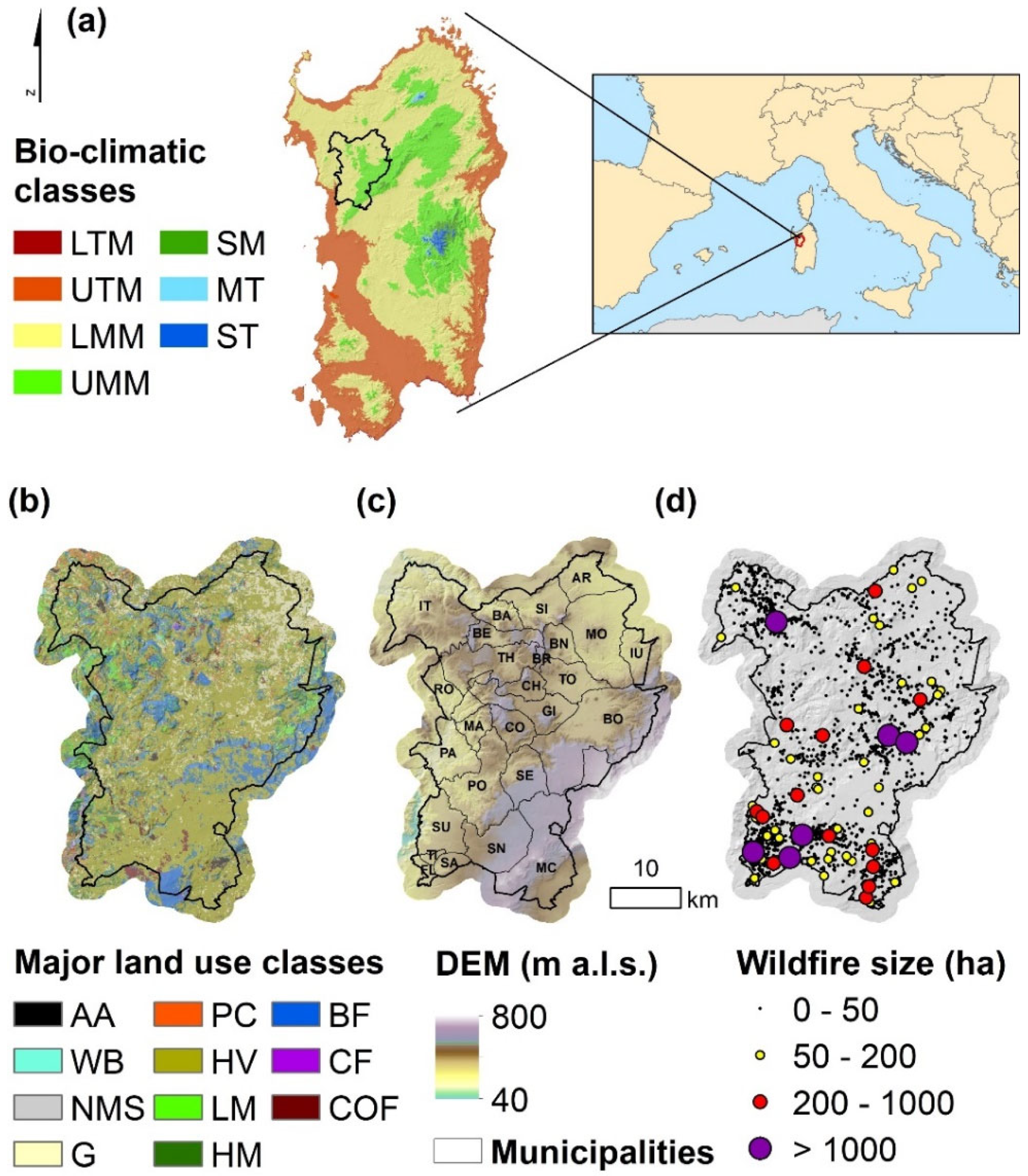
2.1. Study Area and Wildfire Data
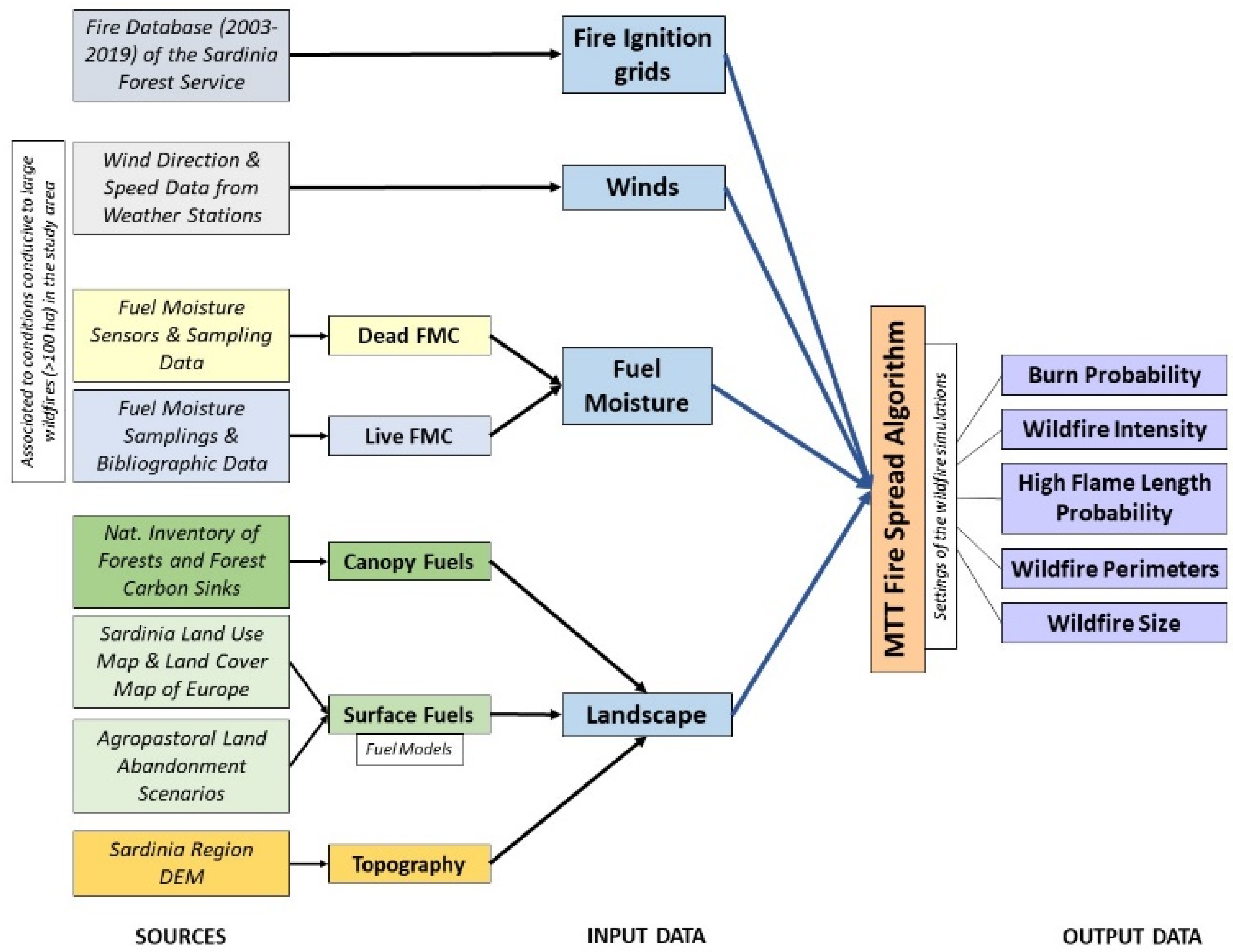
The study area is located in Northwestern Sardinia, Italy, and encompasses about 120,000 ha of land (Figure 1). The terrain elevation ranges from about 40 m a.s.l. to 800 m a.s.l., with an average of about 420 m a.s.l. Overall, the area is mostly characterized by the presence of hilly land, with the highest peaks located in the southeastern portion of the territory (Figure 1c). The main plains are in the eastern part of the study area. From a bio-climatic standpoint, the study area is characterized by mesomediterranean conditions [60], with lower mesomediterranean covering about 2/3 of the lands, and upper mesomediterranean in the remaining part (Figure 1a). The climate is Mediterranean, with variations in temperature and precipitation between the hot and dry summer and the cold and wet conditions of late fall–winter. The average annual precipitation in the study area is about 800 mm, with the highest values (about 980 mm) observed at the highest elevations [61]. The average annual temperature is about 14.5 °C. July is the hottest month of the year, with an average maximum temperature of about 28.5 °C.
The area under investigation is largely covered by herbaceous fuels, namely pastures and grasslands, which represent about 57 and 11% of the study area, respectively (Figure 1b) While grasslands are devoted to autumn-winter herbaceous crop productions, pastures, as well as wooded pastures and shrublands, support the needs of the livestock farms, which are fundamental for the local community economy. Broadleaf forests (about 15%) occupy hills and marginal stony areas (Figure 1b); they are principally represented by deciduous (Quercus pubescens Willd.) and evergreen oaks (Quercus suber L. and Quercus ilex L.). Shrubland formations (11%) are relatively tall in most of the study area and comprise Olea europaea L. var. oleaster Hoffgg. et Link, low-height Quercus spp., Phyllirea spp., Pistacia lentiscus L.; while low maquis (e.g., Cistus spp., Pyrus spp.; Prunus spp.) occupies degraded and grazed lands and steep zones. Fruit-bearing areas cover about 3700 ha of land and are largely represented by olive groves, particularly in the western part of the study area, as well as by sparse vineyards and cherry trees. About 1% of the study area is covered by water bodies.
Anthropic areas cover approximately 1% of land and are principally characterized by sparse and small villages and manufacturing areas. In more detail, about 40,500 inhabitants are distributed in 26 municipalities, the largest of which are represented by Macomer and Ittiri with about 9700 and 8300 inhabitants, respectively [64]. About 40% of these villages have less than 500 inhabitants [64]. The study area has been facing a progressive depopulation since 1990, with a 20% reduction in inhabitants in the last 20 years, and a general decrease in population for all municipalities of the study area [64]; a more relevant decreasing pattern is shown by farms and working units in the agro-silvopastoral sector [65].
In the period 2003–2019, the study area was affected by about 2200 fire ignitions which burned approximately 41,000 ha of lands. The area burned was largely influenced by a few large events: wildfires above 100 ha accounted for 1.5% of the fire ignitions but caused about 75% of the total area burned. The largest wildfires in the study area (Bonorva wildfire, about 10,500 ha; Sindia wildfire, about 5900 ha) were observed in July 2009. The fire season is typically concentrated in the period June–September, with an evident peak (about 2/3 of the total area burned) observed in July.

2.2. Input Data

Spatial data on topography and fuels were assembled and processed with ArcFuels [49,66] to generate a 40 m resolution gridded landscape file as required by FlamMap MTT (Firelab, Missoula, MT, USA) [56]. The wildfire modeling domain included a 2 km buffer around the study area to account for outgoing and incoming wildfires (moving from the neighboring areas) and remove the “edge effect” [67] and was close to 165,000 ha. Elevation, slope, and aspect were obtained from 10 m digital elevation data of the island [62]. Surface fuel types were mapped by combining the 2008 Sardinian Land Use Map [62] with the 10 m Land Cover Map of Europe, 2017 [63]. We initially identified a set of main fuel types, and we then associated each fuel type with either a standard or custom model [44,68,69,70] (Table 1). For surface fuels of forest areas, we customized fuel load and depths for the different bioclimatic areas based on field sampling data [71]: overall, moving from the LMM to UMM bioclimatic zones, we increased by 20% both dead and live fuel loads in forest and shrubland surface fuels, as well as the fuelbed depth of shrublands (Table 1). We also used fuel load and depth data from destructive samplings conducted in Sardinian abandoned pastures and grasslands in recent years to build the reference fuel model for abandoned herbaceous lands. Canopy metrics (canopy cover, canopy bulk density, canopy base height, and canopy height) for forest areas were estimated using as reference the data from the National Inventory of Forests and Forest Carbon Sinks [72] relative to Quercus suber L. and Quercus pubescens L. stands.
Fuel moisture content (FMC) for dead fuels was determined using the time series of fuel moisture measurements collected in Sardinia by a network of fuel moisture sensors located in 14 measurement stations and covering diverse bioclimatic zones. Fuel sensor data were validated considering destructive samplings mostly conducted in Northern Sardinia [73,74,75,76]. Dead FMC values were determined by calculating the 3rd percentile observed in the fuel stick time-series for the main bioclimatic zones. The values used for wildfire simulations ranged from 6 to 10% (1 h time lag dead fuels) to 10–14% (100 h time lag dead fuels), with a gradient from the hottest to the moistest zones of the study area according to the Sardinia Bioclimatic map [60]. The live FMC values accounted for the driest periods of the fire season and were derived both from data collected in northern Sardinia from 2003 to 2021 and from previous studies [77,78]; these data were tuned to consider the differences between bioclimatic zones (Figure 1a).
Regarding the wildfire data, we used the 2003–2019 wildfire database provided by the Sardinia Forest Service. The wildfire database contains information on ignition point coordinates, municipality, ignition date, fire size, as well as the perimeter shapefile. A smoothed ignition probability grid was developed from the historical wildfire database, considering all fire occurrence locations in the study area. The ignition probability grid was created with ArcGIS 10.8 (Esri Inc., Redlands, CA, USA) using the point density method with a 5 km bandwidth and was held as constant input for all fire simulations. The five wind directions (SW, NW, W, S, NE) associated with large wildfires (>100 ha) in the study area were derived from weather data, wildfire reports, and information from the Sardinia Forest Service. Overall, SW winds contributed to about 68% of the total area burned, followed by W and NW winds, with about 14 and 9%, respectively.
A graphical flowchart of the main data sources and their combinations to run the wildfire spread modeling simulations is provided in Figure 2.

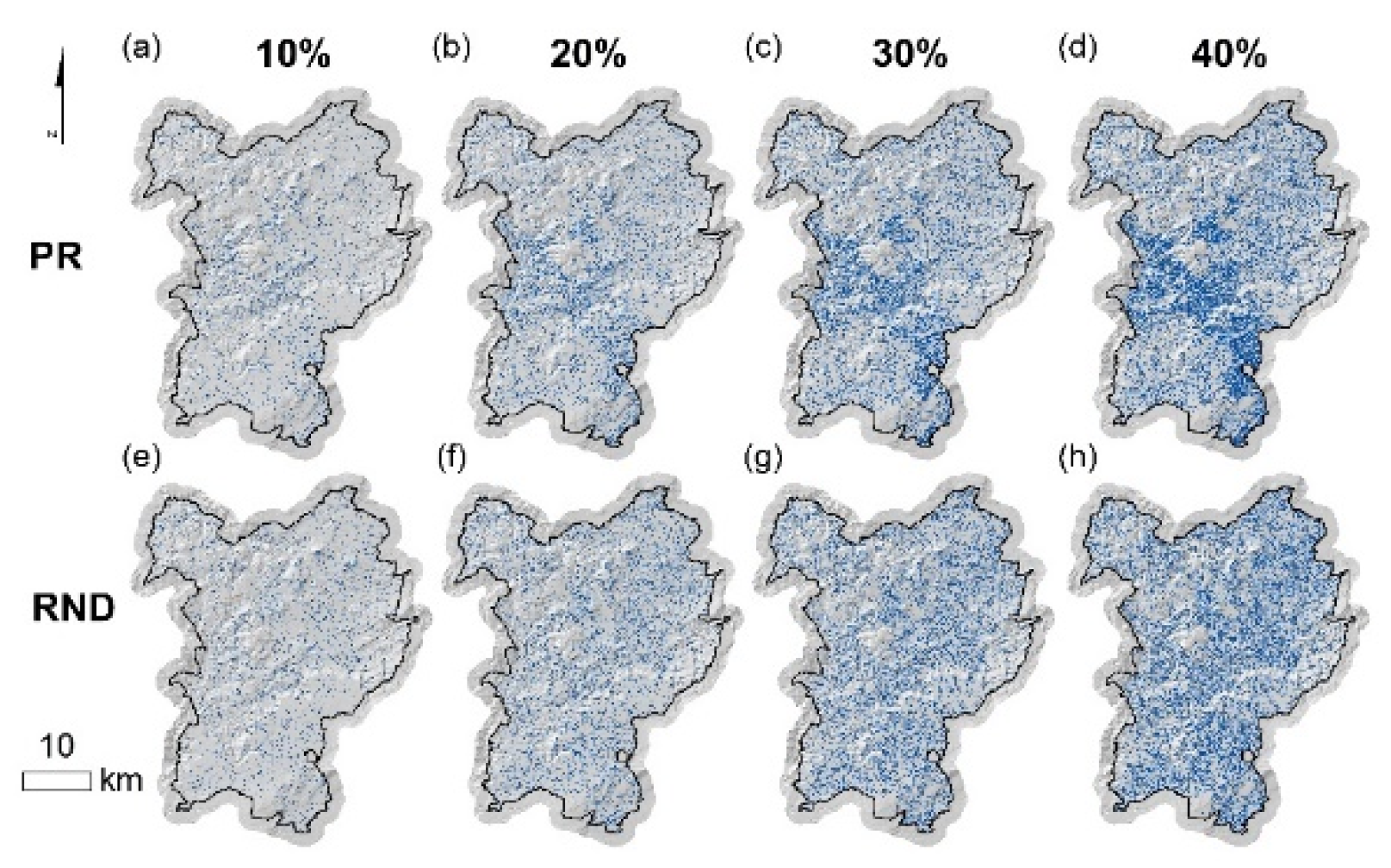
2.3. Land Abandonment Scenarios

We considered different scenarios of land abandonment for agropastoral vegetation types (namely herbaceous vegetation and grasslands, fuel models which cover about 64% of the study area). The land abandonment scenarios hypothesized a variation in dead fuel load and depth within given polygons with respect to the control conditions (Table 1); the short-term effect of agropastoral land abandonment was therefore the transition to taller herbaceous fuels with higher load. Each land abandonment scenario was used to originate a 40 m resolution raster file for wildfire simulations, as described below. Overall, we generated 9 land abandonment scenarios, which consisted of the control conditions (NA, no abandonment) and 8 scenarios obtained by the combination of 4 abandonment intensity levels and 2 spatial patterns of abandonment (Figure 3a–h). Regarding the abandonment intensity levels, we constrained the abandonable area to 10% (≈7700 ha), 20% (≈15,400 ha), 30% (≈23,100 ha), and 40% (≈30,800 ha) of the total area covered by herbaceous fuels in the study area. We imposed specific criteria for the spatial selection of the abandonment units to be for each abandonment intensity level (from 10 to 40%). We first created a 200 m resolution fishnet to split the study area into 4 ha cells, and we then intersected the fishnet with grasslands and herbaceous vegetation: all polygons that intersected those fuel models were considered potentially abandonable. A priority in the selection of land abandonment units was given to agropastoral lands located in areas with slope above 20° (≈2400 ha), that are characterized by agronomic and physical constraints and therefore more complex to be efficiently managed. To select the remaining fishnet polygons, two different criteria were applied. The first method was based on the selection of random polygons, the second criterion was linked to the actual land abandonment patterns in the study area. For the latter, we first calculated a municipal land abandonment index (AI), computed as the ratio between the working units in agro-silvopastoral activities (year of reference 2010) and the variation in the municipal population (2021 vs. 2001). Municipalities with the highest decrease in population and the lowest working units in agro-silvopastoral activities exhibited the highest AI values and therefore were prioritized in the selection of polygons for land abandonment. We then assigned the AI values to the municipality centroids and spatialized the AI using the inverse distance weighting function of ArcMap 10.8 with a 10 km radius, to obtain a continuous spatial map that discriminated the level of prioritization of the fishnet polygons.

2.4. Wildfire Simulations

Wildfire simulations were performed using the minimum travel time (MTT) spread algorithm of Finney (2002) as implemented in its command-line version called FConstMTT (Firelab). The MTT algorithm calculates a two-dimensional fire growth, under constant weather, following the Huygens’ Principle, by searching for the pathways with minimum spread time from the cell corners at an arbitrary resolution set by the user. Surface wildfire spread is predicted according to Rothermel’s equation [79]; crown fire initiation and spread are calculated according to Van Wagner [80] and Rothermel [81], respectively. The MTT algorithm was previously calibrated in the study area and in Sardinia, as reported in several previous studies [44,58,76,82].
For each abandonment scenario, we simulated about 17,000 wildfire seasons. The number of fires simulated was adequate to fully saturate the study area, as well as to guarantee that all pixels with burnable fuels were burned at least once and that individual pixels were burned on average about 100 times in the control conditions. The ignition points were located within the burnable fuels of the study area, according to the historical wildfire ignition probability grid. Simulations were run at 40 m resolution, consistent with the landscape files, with constant wind speed (35 km h−1) and a fixed burning period of 8 h. The dominant wind directions associated with the largest fires observed in the study area, with their relative incidence, were used as input for the wildfire spread modeling.
For each scenario and the whole modeling domain, the wildfire simulations generated a burn probability (BP) raster, a frequency distribution of flame lengths (FL) in twenty 0.5 m for each pixel, a fire size list (FS), and simulated wildfire polygons. The conditional burn probability is a relative measure that quantifies the chance that a pixel will burn given an ignition in the study area. We then derived the annual burn probability (aBP), which represents the annual likelihood of burning given the current landscape and conditions, calculated as the number of times a pixel burns divided by the modeled wildfires seasons, and can range from 0 (the pixel never burns) to 1 (the pixel burns annually) [76,83]. From the frequency distribution of FL values for each pixel, we derived the conditional flame length (CFL), which represents the probability-weighted flame length given a fire occurs in the modeling domain. In addition, we estimated the high flame length probability (HFLP), that is the probability distribution of high flame length (>2.5 m) in a pixel, given the condition that a wildfire burns the pixel, as well as the number of pixels presenting HFLP > 0. We then derived a potential fire size (FS) raster, which was obtained by smoothing the simulated ignition points file using the inverse distance weighting function of ArcMap 10.8, with a 5 km search distance.

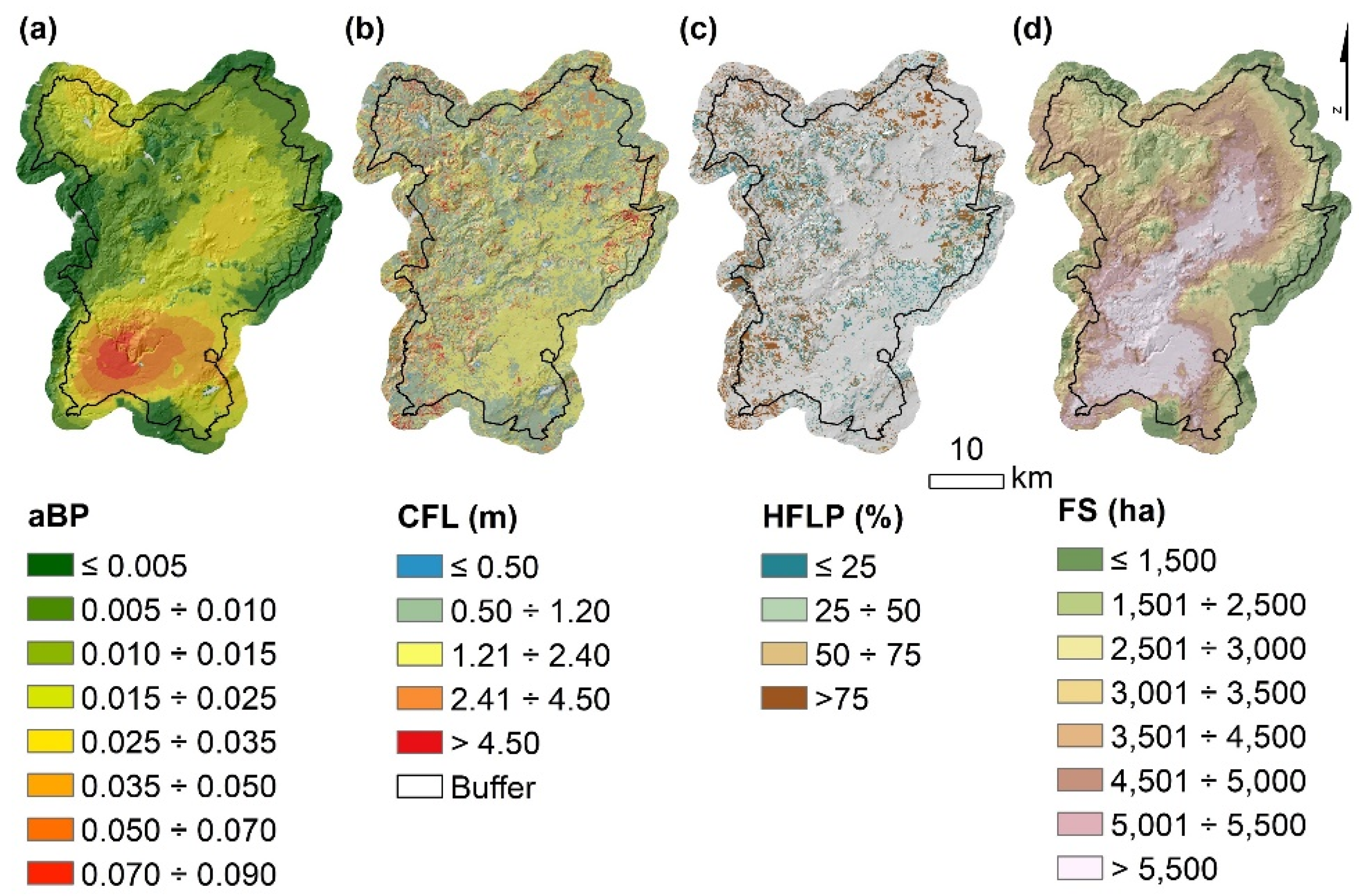
2.5. Wildfire Hazard and Likelihood Analysis

A wildfire hazard and likelihood assessment was carried out to compare the different land abandonment scenarios in the study area and was performed considering diverse spatial layers of reference. A first evaluation was carried out at the landscape level, considering the wildfire simulation outputs in the whole modeling domain and characterizing the wildfire potential profiles for each abandonment scenario. We then focused on the municipal level by intersecting the simulation outputs with the municipal boundaries and calculating the average values of aBP, CFL, HFLP, and FS. Wildfire outputs were finally summarized for the different fuel types to highlight differences among the diverse vegetation types and abandonment scenarios.
The Kruskal–Wallis non-parametric test was applied to evaluate whether the differences among spatial patterns of abandonment and abandonment intensities, considering aBP, CFL and FS variables, were statistically significant. The Bonferroni post hoc test was used for pair-wise comparison among the 9 groups to assess the group differences. To evaluate the effects of land abandonment on HFLP, focusing on the hectares characterized by high flame length, we used the Kappa statistic, based on the calculation of the confusion matrix between the raster files provided by the simulator for each spatial pattern of abandonment and percentage of abandonment. The Kappa statistic measures the level of association between the abandonment scenarios for the areas with flame length above 2.5 m. The significance of the association between pairs of raster files was evaluated by the McNemar’s χ2 test.

3. Results

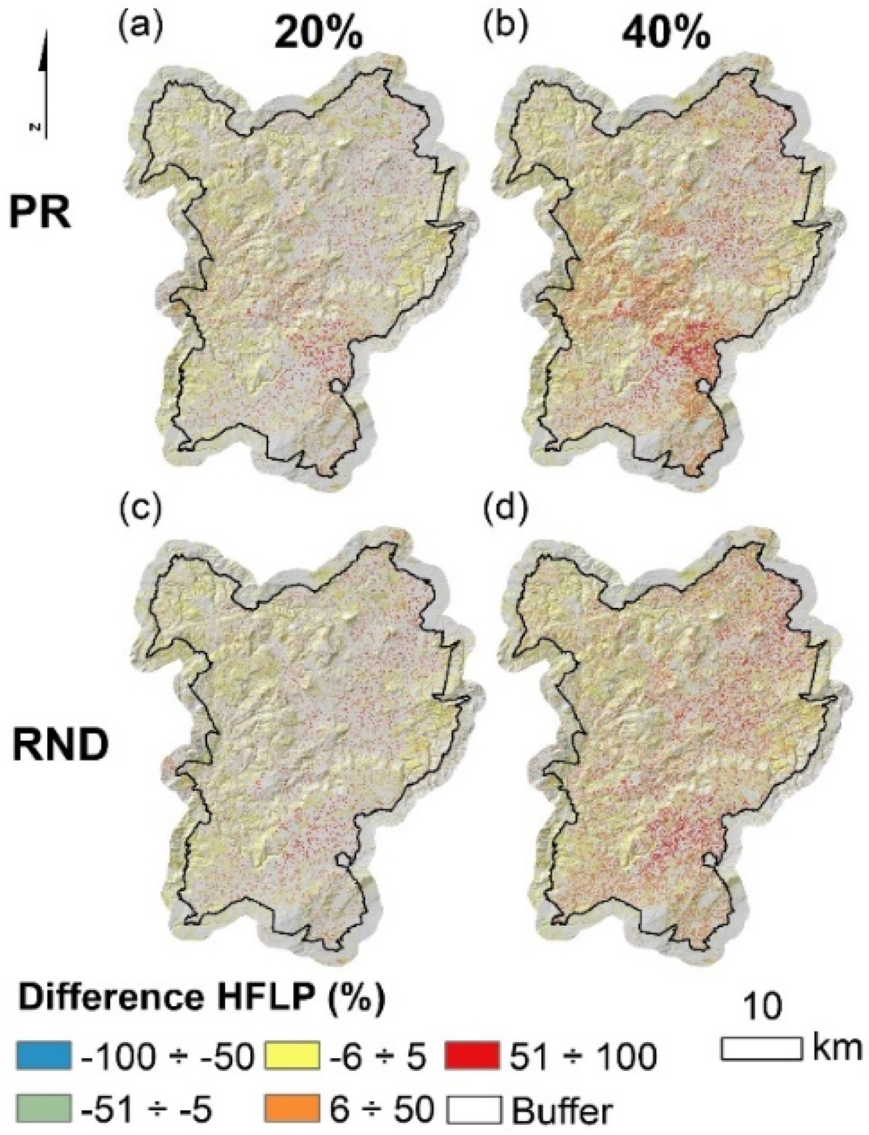
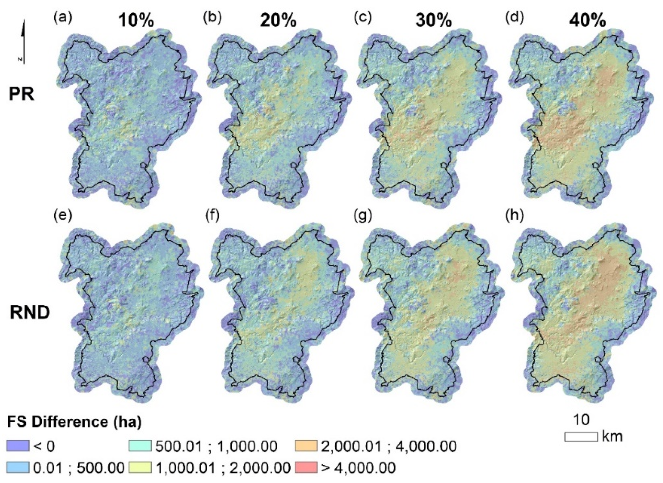
3.1. Wildfire Hazard and Likelihood at the Landscape Level

The highest wildfire likelihood (aBP > 0.035) and fire size (FS > 5000 ha) values (Figure 4a,d) were mainly concentrated in the southern and central portions of the study area, where herbaceous surface fuels cover large parts of the landscape and historical fire occurrence is high (Figure 1). The north-western portion also showed high likelihood values (aBP > 0.025). Wildfire hazard, in terms of conditional flame length (CFL) and high flame length probability (HFLP) (Figure 4b,c), highlighted a wide range of values throughout the landscape. Overall, the highest wildfire hazard values (CFL > 2.4 m and HFLP > 50%) were associated with complex topography, as well as with high fuel load areas, especially in the eastern and western parts of the study area. In contrast, the lowest values were observed in flat areas covered by grasslands and sparse vegetation.
Agropastoral land abandonment substantially increased the wildfire hazard and likelihood outputs (Table 2 and Figure 5). We found the highest increase in aBP, CFL, HFLP, and FS in RND and PR scenarios as land abandonment rose to 40%. For instance, the average annual burn probability (aBP) increased from 2.05·10−2 for the control conditions to 2.63·10−2 for RND-40% (i.e., an increase in annual area burned of about 700 ha per year). The wildfire potential indicator that exhibited the most relevant growth moving from NA to land abandonment intensity of 40% was HFLP, which at the landscape scale increased from about 26,000 ha to about 55,900 ha in both RND and PR abandonment scenarios. The Kruskal–Wallis analysis and the Bonferroni post hoc test showed that the increasing level of land abandonment significantly (p = 0.01) affected wildfire hazard and likelihood outputs (Table 2).
To further explore the spatial arrangement of wildfire profiles for the study area and determine the most important variations in wildfire hazard and likelihood due to land abandonment, we produced an exposure map, based on the combination of simulated aBP and CFL (Figure 5). In the control conditions (NA), the high exposure areas (aBP > 0.017 and CFL > 2.4 m) were observed in about 5% of the study area, mostly concentrated in the south-western and north-western pixels. For the highest intensity of land abandonment, high exposure areas grew to 10.6 and 10.8% (PR and RND, respectively) (Figure 4). Nevertheless, about 46% of the land was characterized by moderate wildfire hazard and likelihood (aBP < 0.017 and CFL < 2.4 m). The land abandonment increase caused a progressive reduction of moderate-to-low exposure areas, which dropped below 35% in both PR-40% and RND-40% scenarios. In the NA scenario, about 7.5% of the study area presented high conditional flame length values (CFL > 2.4 m) associated with low burn probabilities (aBP < 0.017); the increase in the percentage of land abandonment did not significantly affect this exposure factor. The high burn probabilities (aBP > 0.017) and moderate hazard (CFL < 2.4 m) areas covered about 41.5% of the land in the control conditions; the hectares of land characterized by these conditions increased as a function of the percentage of land abandonment, with peaks of 49.8 and 50.7% observed in PR-40% and RND-40%, respectively (Figure 5).
Figure 6 presents the high flame length probability (HFLP) difference maps between the two spatial patterns of land abandonment scenarios (considering abandonment intensities of 20 and 40%) and the NA conditions. These maps show the probability that any given pixel had experienced a variation in the probability of having intense wildfires due to different patterns and intensities of land abandonment. As expected, for both spatial patterns of abandonment, the variations in HFLP were more relevant when higher fractions of the landscape were abandoned (40 vs. 20%). The zones that highlighted the widest shifts in HFLP were principally located in the south-eastern portion of the study area for both PR and RND scenarios. The variation in HFLP values was overall relatively small (in the range (−5%; 5%) for most of the landscape (about 87% with 20% abandonment percentage, about 76% with 40% abandonment percentage). The areas which presented the most substantial differences (>50%) in HFLP between pre- and post-abandonment conditions were close to 4% of the study area (considering 40% of land abandonment intensity).
Furthermore, we analyzed the differences in fire size (FS) between the two spatial patterns of land abandonment scenarios, considering all percentages of abandonment, and the NA conditions (Figure 7). The maps reveal prominent changes induced by land abandonment scenarios, in particular with the highest abandonment intensities, regardless of the spatial patterns of abandonment. For example, the percentage of land with low fire size class variation (<500 ha) in the post-abandonment condition ranged from ~69% (10% abandonment intensity) to ~18% (40% abandonment intensity). The areas that presented variations in fire size in the range (500–2000 ha) moved from ~31% (10% abandonment intensity) to ~60–65% (30 and 40% abandonment intensity, respectively). Large wildfire occurrence increased with the rise in the percentage of abandonment; for instance, in the PR-40% scenario, about 25,000 hectares of land had the potential to originate very large events (with size > 2000 ha than in the NA conditions).
Not surprisingly, land abandonment caused a fire size distribution shift toward more frequent large wildfire scenarios (Figure 8). Likewise, the fire size distributions presented a decreasing trend in frequency for the most common classes. The peak in the fire size frequency was observed in the class 6000–7000 ha; starting from agropastoral land abandonment greater than or equal to 30%, this peak shifted to the next size class (7000–8000 ha). Yet, in the case of RND-40%, the principal fire size class was in the range 8000–9000 ha, with about 20.5% of simulated fire ignitions able to produce such large events. Fires smaller than 2000 ha were about 5% of the total wildfire simulations for the NA conditions, and decreased progressively, as a function of the percentage of agropastoral land abandonment, to 3% (with an abandonment intensity of 40%). On the other hand, fires with a size greater than or equal to 9000 hectares occurred only with abandonment rates higher than or equal to 20% and accounted for about 8.5 and 10% of total fire ignitions in PR-40% and RND-40%, respectively.

3.2. Wildfire Hazard and Likelihood at the Municipality Level

The effect of land abandonment on wildfire outputs was also analyzed for the 26 different municipalities included in the study area (Figure 1 and Figure 9). Considering the NA conditions, three municipalities presented an average aBP higher than 4.5·10−2: Sindia (5.24·10−2), Suni (4.94·10−2), and Sagama (4.85·10−2) (Figure 9). These villages had the highest aBP values for the study area regardless of the land abandonment intensity and pattern. Sindia evidenced the highest aBP (6.16·10−2) among the municipalities, observed with the RND-40% scenario. In contrast, the lowest aBP values were observed in Romana (Figure 9), where the values ranged from a minimum of 4.40·10−3 (NA conditions) to 5.60·10−3 (PR-40%). In some cases, the shift from the NA conditions to a 40% land abandonment intensity raised the aBP over 0.01. For example, the highest increase in aBP was found in Semestene (+0.010) for the RND scenario, and in Torralba (+0.0109) and Pozzomaggiore (+0.0103) for the PR scenario (Figure 9).
Considering the NA conditions, the three municipalities with the highest average flame length were Suni, Thiesi, and Ittiri, with average CFL of 1.957 m, 1.730 m, and 1.728 m, respectively (Figure 9); in contrast, the lowest average CFL value was observed in Bonnanaro, with 1.197 m. As the percentage of land abandonment increased, a rise in the average flame length values was observed, with the highest values in RND-40% and PR-40% scenarios. The shift from NA to PR-40% conditions resulted in an increase in average CFL, ranging from a maximum of +0.432 m and +0.419 m in Semestene and Mara, respectively, to a minimum of +0.128 m in Banari (Figure 9). In the case of the differences between NA and RND-40%, the increase in mean CFL varied from +0.411 m in Mores and +0.380 in Ardara to a minimum of +0.174 in Banari and Thiesi. The peak in mean CFL values was shown by Suni, which presented values of 2.131 m and 2.149 m for PR-40% and RND-40%, respectively. As already mentioned, the pattern of abandonment, random vs. priority-based, affected the average flame length value at the municipal level, leading to marked differences between these two patterns in some cases. For example, in five municipalities (Mara, Semestene, Romana, Padria and Cossoine), the priority-based pattern resulted in an increase in average CFL, at the 40% abandonment level, which was 0.10 m higher than the random pattern. However, for other municipalities such as Mores or Ittireddu, the highest average CFL values were observed with the RND scenario.
We then calculated the percent of municipal land characterized by high flame length (FL > 2.5 m). The results are reported in Figure 9, and the municipalities are classified into four classes according to the percent of the land with high flame length (<15, 15–30, 30–45, and >45%). In the NA conditions, only four municipalities (Ittiri, Thiesi, Banari, and Suni) highlighted more than 30% of the municipal land with FL > 2.5 m; in contrast, eight municipalities presented FL values > 2.5 m in less than 15% of their territory, with the minimum recorded in Borutta (10.07%). Furthermore, for this output, the increase in land abandonment caused a resulting growth in the percentage of municipal area with high flame length. The municipalities which showed potential to have FL > 2.5 m in more than 45% of their municipal area were 12 in the PR-40% conditions, with peaks above 60% observed in Padria (61.96%), Semestene (61.26%), Romana (60.11%), and Mara (60.03%), and 13 in the RND-40% conditions, peaking at 56.66% in Suni, and with percentage values overall smaller than in PR-40%. Significant increases in the municipal land with the potential to produce FL > 2.5 in the shift from NA to PR-40% conditions were observed in the municipalities of Semestene, Borutta and Mara, with changes slightly higher than 40%; the differences induced by the shift from NA to RND-40% were more limited in terms of maximum values, with the highest variations close to 32% and recorded in Borutta and Sindia.

3.3. Wildfire Hazard and Likelihood at the Fuel Type Level

We analyzed how the different land abandonment scenarios affected wildfire hazard and likelihood by the main fuel type classes in the study area (Table 3). Overall, increasing land abandonment intensity resulted in an increase in aBP; plus, for the same intensity of land abandonment, RND patterns often presented higher aBP than PR ones (Table 3). The highest aBP values were observed in abandoned herbaceous fuels (AB) and agropastoral vegetation (AP, which included grasslands, mixed agricultural and herbaceous pastures) types; Mediterranean maquis (MM) and forests (FOR) evidenced lower average values, with the lowest values presented by the latter fuel type. For instance, considering the RND-40% conditions, AB and AP showed aBP close to 2.90·10−2, while MM and FOR evidenced aBP values of 2.20 and 1.74·10−2, respectively.
Regarding the average CFL, the variations induced by land abandonment for a given fuel type, both in relation to percentage and patterns of abandonment, were, as expected, very small (Table 3). In addition, there was a clear difference in average CFL values between AB and AP, which in the PR-40% and RND-40% conditions dropped from 2.02 to 1.32 m, respectively. A similar consideration applies to HFLP, for which increasing the intensity of abandonment from 0 to 40% resulted in a slight growth in HFLP values for each of the main fuel types (Table 3). An evident difference in HFLP between AB and AP can be highlighted (with land abandonment intensity at 40%, HFLP of about 25 and 5%, respectively). For MM and FOR, HFLP values varied, depending on the percentage of land abandonment, in the range 80–81% and 7–9%, respectively.
Finally, as observed for aBP, the fire size (FS) also increased significantly as a function of the percentage of land abandonment (Table 3). In addition, for given intensities of land abandonment and fuel type, the random pattern produced larger average FS than the priority-based pattern. In general, the fuels able to originate the most extensive fires were herbaceous fuel types: maximum FS peaks were recorded for RND-40% conditions, with values of about 5890 and 5844 ha for AB and AP, respectively. Yet, the non-abandoned herbaceous fuel types, characterized by lower load and depth than the abandoned ones, showed average FS of about 4448 ha in the baseline (NA) conditions. From this point of view, for all the main fuel types presented in Table 3, the increase in the percentage of land abandonment resulted in higher wildfire transmission capacity in the landscape and thus in a growth of the average area covered by wildfires.

4. Discussion

Many previous studies applied wildfire spread models to analyze the spatial and temporal effects of fuel characteristics and conditions on wildfire spread, exposure and risk, particularly as far as fuel treatments and management strategies were concerned [59,84]. Yet, the use of wildfire spread modeling to quantify the short-term consequences of land abandonment in terms of potential propagation and behavior has been mostly unexplored in the Mediterranean Basin. This work represents one of the first applications of wildfire spread modeling to measure the response of wildfire variables to changes in spatial patterns and intensity levels of agropastoral land abandonment in fire-prone Mediterranean ecosystems. Moreover, this study is the finest-scale (40 m resolution) application of wildfire spread simulation modeling to explore the above topic in southern Europe, for a very large study area and the related modeling domain extent (120,000 ha and 165,000 ha, respectively). The study was performed in a pilot site located in western Sardinia (Italy), characterized by significant portions of land covered by herbaceous surface fuels, formerly exploited by grazing and agricultural productions and now increasingly subject to a fast land abandonment process. This phenomenon has also been described in other fire-prone Euro-Mediterranean areas, where agropastoral systems provide meager benefits and livestock farming activities are decreasing dramatically. In our work, we focused on the short-term effects of agropastoral land abandonment in Sardinia, which is promoting the transition to higher load and depth herbaceous fuels. In fact, after several years of intensive grazing and agricultural practices (tillage, sowing, etc.), the seed bank in abandoned agropastoral lands is largely characterized by herbaceous or pioneering species; afforestation by shrublands or forests requires a number of years, which can vary depending on the proximity to forests, climate and topography.
Several studies carried out in the Mediterranean Basin reported that agricultural land abandonment led to natural vegetation encroachment or afforestation, increasing landscape homogeneity and fuel contiguity, and changes in wildfire behavior and regime patterns [18,19,23,53,54,85,86,87]. Our results confirmed that, in Mediterranean areas, agropastoral land abandonment has the potential to boost wildfire hazard and likelihood, which in the present study were assessed considering several indicators, including annual burn probability, fire size and fire intensity. Overall, as expected, the increase in the percentage of land abandoned promoted, for both spatial abandonment scenarios, a growth in simulated wildfire outputs; for instance, moving from NA to a land abandonment intensity of 40%, areas with high flame length probability (HFLP) increased from about 26,000 ha to about 55,900 ha in both RND and PR scenarios, while aBP from 2.05 to 2.63·10−2 in RND-40%. These results are in line with previous studies conducted in southern Europe; increases in wildfire frequency, intensity and size in areas characterized by land abandonment processes and growing landscape homogeneity were also highlighted by Vega-Garcia and Chuvieco [85], Azevedo et al. [54], and Sil et al. [53]. Moreover, the maps obtained by the combination of simulated aBP and CFL outputs allowed us to identify the areas more likely to suffer intense wildfires, and how these areas spatially differed due to changes in spatial patterns and intensity levels of land abandonment. The above outputs showed complex patterns, and a high wildfire hazard did not necessarily connote a high likelihood, and vice versa. In this regard, we observed a growth in both potential occurrence of intense wildfires and hectares of land beyond the suppression capability of terrestrial forces as the percentage of land abandonment increased, apart from the spatial patterns of abandonment. In addition, we evidenced that the percentage of land with the highest burn probability and hazard values (aBP > 0.017 and CFL > 2.5 m) roughly doubled (5% vs. 10.8%) moving from the control conditions to a 40% level of abandonment of agropastoral areas. Therefore, under high levels of agropastoral land abandonment, wildfire control by terrestrial forces can be much more challenging and, consequently, the need for aerial means to support wildfire suppression teams and contain wildfire spread could likely increase. Regarding wildfire management in Mediterranean areas, paradoxically, even the fire exclusion policy and the progressive enforcement of suppression forces, with the final aim of suppressing a fire as quickly as possible once started, can further contribute to fuel accumulation; considering that megafires are mainly associated with extreme weather, and that in southern Europe wildfire frequency and impacts are expected to increase in future years, the current strong investment in fire suppression and exclusion policies could be conducive to a higher occurrence of large and extreme wildfire episodes, which could be exacerbated in a context of farmland abandonment [24,50,88,89,90,91,92,93].
We evidenced how increasing levels of agropastoral land abandonment caused consequential and progressive increases in average aBP and FS for all fuel types, while lower effects were observed when focusing on CFL. The latter result is not surprising, considering that the study area is characterized by a high presence of herbaceous fuels and that fuel variations due to land abandonment were only applied to herbaceous fuel types, which typically present lower fire intensity values than wildlands and forests. In broad terms, the highest average aBP and FS values were observed in abandoned herbaceous fuels and agropastoral vegetation types, considering the highest (40%) abandonment intensity levels. Therefore, herbaceous fuels evidenced a high wildfire transmission capacity at the landscape scale, and thus played a relevant role in supporting wildfire propagation and growth, particularly when the percentage of agropastoral land abandonment was above 20%. The fact that agricultural areas, pastures and unmanaged wildlands are key land categories with a strong potential to transmit wildfire exposure and risk to other land types was highlighted by other previous works [76,94,95,96]. In this context, the largest Sardinian wildfires of the last decades, Nuoro (about 9000 ha, July 2007), Bonorva (about 10,600 ha, July 2009), and Montiferru (about 13,000 ha, July 2021), were ignited and quickly spread firstly in areas almost entirely characterized by herbaceous-type land tenures, and then propagated in the surrounding landscape driven by windy and very dry weather conditions.
The modeling approach based on wildfire propagators such as the one proposed in this paper has, among many others, the advantage of being able to spatially assess burn probability, wildfire hazard and exposure at the landscape level [46,76,96,97,98] or the variations in wildfire risk or related disturbances caused by alternative environmental conditions or scenarios [48,51,99,100,101,102,103,104,105]. In our study, the modeling approach carried out allowed us to map the differences induced by the two abandonment patterns tested for increasing levels (from 0 to 40%) of land abandonment. From this point of view, while the differences between PR and RND scenarios in terms of average wildfire outputs (e.g., aBP, CFL, FS, etc.) were quite modest, the spatial variations were more important (as highlighted in Figure 5, Figure 6 and Figure 7 and 9). It was therefore possible to determine which areas or municipalities were potentially most affected by the worst wildfire spread and behavior conditions due to different levels of land abandonment. This spatial information is very important, as it permits to identify which zones should be given higher priority or attention in relation to reducing abandonment of agropastoral areas, in order to lower fire impact with fuel treatments, or inform decision-making [44,93,106]. For instance, programmed grazing plans can be promoted in strategic areas affected by land abandonment processes to reduce continuity, height and load of fine fuels, thus decreasing the likelihood of an ignition source coming in contact with flammable fuels, lowering fire spread rates and intensity, and increasing wildfire suppression effectiveness [107,108,109,110]. Our work highlighted the crucial role played by agriculture and pastoral activities in affecting wildfire potential and risk in Mediterranean areas. On one hand, agropastoral zones were identified as preferential sources of fire ignitions in some Southern EU areas [111,112,113,114]. On the other hand, managed agropastoral areas are less fire-prone and present lower wildfire hazard and likelihood profiles than abandoned herbaceous fields, as proved in this work. In this sense, the European Union’s Common Agricultural Policy (CAP) could and should play a key role in reducing wildfire risk, particularly in those areas characterized by the relevant phenomena of agropastoral land abandonment, by supporting farming activities and fostering the maintenance of extensive livestock grazing and agricultural productions in remote zones and in areas prone to abandonment [90]. Moreover, promoting and facilitating land associations or other forms of aggregation among private owners, as well as land property reorganization actions, could be relevant to reduce fragmentation and pulverization of land ownership, which in turn can have significant positive impacts on agropastoral farms and production chains, can lower land abandonment processes, and can thus reduce megafire occurrence.

5. Conclusions

This work is one of the first applications of wildfire spread modeling to estimate at fine-scale the potential changes in wildfire hazard conditions induced by diverse scenarios of agropastoral land abandonment in fire-prone Mediterranean ecosystems. We advance knowledge of how alternative spatial patterns and intensity levels of land abandonment can modify potential wildfire behavior and spread in areas mainly characterized by herbaceous land tenures. As herbaceous fuels increase in load and height, the wildfire hazard progressively rises, and wildfire transmission becomes more significant at the landscape scale. Given a fixed percentage of land abandonment, diverse spatial patterns of abandonment induce spatial variations in wildfire likelihood and hazard, while the average values (as measured by indicators such as burn probability, fire size, or flame length) at the landscape scale do not significantly differ. Our study demonstrates that land abandonment in agropastoral areas can alter wildfire spread and promote the likelihood of large and fast-spreading events. The approach proposed allows to quantify and map the risks posed by future wildfires in the context of agropastoral land abandonment. This can inform prevention and planning strategies to mitigate wildfire impacts and losses for ecosystems and anthropic values.

Author Contributions

Conceptualization, M.S. (Michele Salis), L.D.G. and B.A.; methodology, M.S, F.A.-U., G.P. and B.A.; software, M.S. (Michele Salis), F.A.-U. and B.A.; validation, R.J., C.S., M.S. (Matilde Schirru), A.V. and A.C.; formal analysis, M.S. (Michele Salis), L.D.G., R.J., F.A.-U. and B.A.; investigation, M.S. (Michele Salis), L.D.G., V.B. and B.A.; resources, L.D.G., R.J. and C.S.; data curation, L.D.G., R.J., C.S., M.C. and F.P.; writing—original draft preparation, M.S. (Michele Salis), L.D.G., R.J. and B.A.; writing—review and editing, F.A.-U., G.P. and V.B.; visualization, L.D.G., M.C. and F.P.; supervision, M.S. (Michele Salis), P.D. and B.A.; project administration, P.D.; funding acquisition, P.D. All authors have read and agreed to the published version of the manuscript.

Funding

This work was funded by the MED-Star (grant no. E88H19000120007), Med-Foreste (grant no. B85I1900010007) and Med-Coopfire (grant no. B81I1900010007) projects, supported by the EU under the cross-border “Programma Italia–Francia Marittimo” 2014–2020; the “FOE2019—Climate Change: risk mitigation for sustainable development” (Ministerial Decree no. 856/19) project, funded by the Italian Ministry of Education, University and Research (MIUR); the FirEUrisk (Grant agreement ID: 101003890) project, funded by the EU under the “H2020-EU.3.5.—SOCIETAL CHALLENGES—Climate action, Environment, Resource Efficiency and Raw Materials” Programme.

Data Availability Statement

Not applicable.

Acknowledgments

We thank the Sardinia Forest Service and the Sardinia Environmental Protection Agency–Weather-Climate Department for collaborating in this study with data, ideas and suggestions and for supporting the calibration phase of the simulation modeling approach. We thank Alan Ager of the USDA Forest Service and Stuart Brittain of Alturas Solutions for adapting the fire behavior library to the Sardinia case study. We also thank the anonymous Reviewers for the constructive remarks and valuable contributions to improve this manuscript.

Conflicts of Interest

The authors declare no conflict of interest.

References

  1. Keeley, J.E.; Bond, W.J.; Bradstock, R.A.; Pausas, J.G.; Rundel, P.W. Fire in Mediterranean Ecosystems: Ecology, Evolution and Management; Cambridge University Press: New York, NY, USA, 2012. [Google Scholar] [CrossRef]
  2. Molina-Terrén, D.M.; Xanthopoulos, G.; Diakakis, M.; Ribeiro, L.; Caballero, D.; Delogu, G.M.; Viegas, D.X.; Silva, C.A.; Cardil, A. Analysis of forest fire fatalities in Southern Europe: Spain, Portugal, Greece and Sardinia (Italy). Int. J. Wildland Fire 2019, 28, 85. [Google Scholar] [CrossRef] [Green Version]
  3. Costa, H.; De Rigo, D.; Libertà, G.; Houston Durrant, T.; San-Miguel-Ayanz, J. European Wildfire Danger and Vulnerability in a Changing Climate: Towards Integrating Risk Dimensions; EUR 30116 EN; JRC119980; Publications Office of the European Union: Luxembourg, 2020; ISBN 978-92-76-16898-0. [CrossRef]
  4. Ribeiro, L.M.; Rodrigues, A.; Lucas, D.; Viegas, D.X. The impact on structures of the Pedrógão Grande Fire Complex in June 2017 (Portugal). Fire 2020, 3, 57. [Google Scholar] [CrossRef]
  5. Forzieri, G.; Girardello, M.; Ceccherini, G.; Spinoni, J.; Feyen, L.; Hartmann, H.; Beck, P.S.A.; Camps-Valls, G.; Chirici, G.; Mauri, A.; et al. Emergent vulnerability to climate-driven disturbances in European forests. Nat. Commun. 2021, 12, 1081. [Google Scholar] [CrossRef] [PubMed]
  6. San-Miguel-Ayanz, J.; Durrant, T.; Boca, R.; Maianti, P.; Libertà, G.; Artés-Vivancos, T.; Oom, D.; Branco, A.; de Rigo, D.; Ferrari, D.; et al. Forest Fires in Europe, Middle East and North Africa 2020; EUR 30862 EN; Publications Office of the European Union: Luxembourg, 2021; ISBN 978-92-76-42351-5. [CrossRef]
  7. EU 2021 Wildfire Season Was the Second Worst on Record, Finds New Commission Report. Available online: https://joint-research-centre.ec.europa.eu/jrc-news/eu-2021-wildfire-season-was-second-worst-record-finds-new-commission-report-2022-03-21_en#:~:text=In%202021%2C%20fires%20were%20observed,large%20number%20of%20massive%20fires (accessed on 24 October 2022).
  8. San-Miguel-Ayanz, J.; Moreno, J.M.; Camia, A. Analysis of large fires in European Mediterranean landscapes: Lessons learned and perspectives. For. Ecol. Manag. 2013, 294, 11–22. [Google Scholar] [CrossRef]
  9. Stefanidis, S.; Alexandridis, V.; Spalevic, V.; Mincato, R.L. Wildfire Effects on Soil Erosion Dynamics: The Case of 2021 Megafires in Greece. Agric. For. Poljopr. Sumar. 2022, 68, 49–63. [Google Scholar] [CrossRef]
  10. Linley, G.D.; Jolly, C.J.; Doherty, T.S.; Geary, W.L.; Armenteras, D.; Belcher, C.M.; Bliege Bird, R.; Duane, A.; Fletcher, M.-S.; Giorgis, M.A.; et al. What do you mean, ‘megafire’? Glob. Ecol. Biogeogr. 2022, 31, 1906–1922. [Google Scholar] [CrossRef]
  11. Fernandes, P.M. Variation in the Canadian fire weather index thresholds for increasingly larger fires in Portugal. Forests 2019, 10, 838. [Google Scholar] [CrossRef]
  12. Carnicer, J.; Alegria, A.; Giannakopoulos, C.; Di Giuseppe, F.; Karali, A.; Koutsias, N.; Lionello, P.; Parrington, M.; Vitolo, C. Global warming is shifting the relationships between fire weather and realized fire-induced CO2 emissions in Europe. Sci. Rep. 2022, 12, 10365. [Google Scholar] [CrossRef]
  13. Jain, P.; Castellanos-Acuna, D.; Coogan, S.C.P.; Abatzoglou, J.T.; Flannigan, M.D. Observed increases in extreme fire weather driven by atmospheric humidity and temperature. Nat. Clim. Change 2022, 12, 63–70. [Google Scholar] [CrossRef]
  14. Ager, A.A.; Preisler, H.K.; Arca, B.; Spano, D.; Salis, M. Wildfire risk estimation in the Mediterranean area. Environmetrics 2014, 25, 384–396. [Google Scholar] [CrossRef]
  15. Fernandes, P.M.; Monteiro-Henriques, T.; Guiomar, N.; Loureiro, C.; Barros, A.M.G. Bottom-Up Variables Govern Large-Fire Size in Portugal. Ecosystems 2016, 19, 1362–1375. [Google Scholar] [CrossRef]
  16. Rodrigues, M.; Mariani, M.; Russo, A.; Salis, M.; Galizia, L.F.; Cardil, A. Spatio-Temporal Domains of Wildfire-Prone Teleconnection Patterns in the Western Mediterranean Basin. Geophys. Res. Lett. 2021, 48, e2021GL094238. [Google Scholar] [CrossRef]
  17. Galizia, L.F.; Curt, T.; Barbero, R.; Rodrigues, M. Understanding fire regimes in Europe. Int. J. Wildland Fire 2022, 31, 56–66. [Google Scholar] [CrossRef]
  18. Moreira, F.; Viedma, O.; Arianoutsou, M.; Curt, T.; Koutsias, N.; Rigolot, E.; Barbati, A.; Corona, P.; Vaz, P.; Xanthopoulous, G.; et al. Landscape-wildfire interactions in southern Europe: Implications for landscape management. J. Environ. Manag. 2011, 92, 2389–2402. [Google Scholar] [CrossRef] [Green Version]
  19. Pausas, J.G.; Fernández-Muñoz, S. Fire regime changes in the Western Mediterranean Basin: From fuel-limited to drought-driven fire regime. Clim. Change 2012, 110, 215–226. [Google Scholar] [CrossRef] [Green Version]
  20. Seidl, R.; Thom, D.; Kautz, M.; Martin-Benito, D.; Peltoniemi, M.; Vacchiano, G.; Wild, J.; Ascoli, D.; Petr, M.; Honkaniemi, J.; et al. Forest disturbances under climate change. Nat. Clim. Change 2017, 7, 395–402. [Google Scholar] [CrossRef] [Green Version]
  21. Turco, M.; von Hardenberg, J.; AghaKouchak, A.; Llasat, M.C.; Provenzale, A.; Trigo, R.M. On the key role of droughts in the dynamics of summer fires in Mediterranean Europe. Sci. Rep. 2017, 7, 81. [Google Scholar] [CrossRef]
  22. Ruffault, J.; Curt, T.; Martin-StPaul, N.K.; Moron, V.; Trigo, R.M. Extreme wildfire events are linked to global-change-type droughts in the northern Mediterranean. Nat. Hazards Earth Syst. Sci. 2018, 18, 847–856. [Google Scholar] [CrossRef] [Green Version]
  23. Ascoli, D.; Moris, J.V.; Marchetti, M.; Sallustio, L. Land use change towards forests and wooded land correlates with large and frequent wildfires in Italy. Ann. Silvic. Res. 2021, 46, 1–10. [Google Scholar] [CrossRef]
  24. Miezïte, L.E.; Ameztegui, A.; De Cáceres, M.; Coll, L.; Morán-Ordóñez, A.; Vega-García, C.; Rodrigues, M. Trajectories of wildfire behavior under climate change. Can forest management mitigate the increasing hazard? J. Environ. Manag. 2022, 322, 116134. [Google Scholar] [CrossRef]
  25. Schuh, B.; Andronic, C.; Derszniak-Noirjean, M.; Gaupp-Berghausen, M.; Hsiung, C.; Münch, A. Research for AGRI Committee—The Challenge of Land Abandonment after 2020 and Options for Mitigating Measures; QA-04-20-287-EN-N; European Parliament, Policy Department for Structural and Cohesion Policies: Brussels, Belgium, 2020; ISBN 978-92-846-7650-7. [CrossRef]
  26. RAS (Regione Autonoma della Sardegna). Comuni in Estinzione-Gli Scenari dello Spopolamento in Sardegna. Progetto IDMS-2013. Programma Regionale di Sviluppo 2010–2014. Available online: https://www.sardegnaprogrammazione.it/documenti/35_84_20160802092030.pdf (accessed on 24 October 2022).
  27. Porqueddu, C. Sardinian Grasslands, & Rangelands. In Grasslands, & Herbivore Production in Europe, & Effects of Common Policies; Huyghe, C., de Vliegher, A., van Gils, B., Peeters, A., Eds.; Editions Quae: Versailles, France, 2014; pp. 184–190. ISBN 978-2-7592-2156-1. [Google Scholar]
  28. Nori, M.; Ragkos, A.; Farinella, D. Agro-pastoralism as an asset for sustainable Mediterranean islands. In Mediterranean Issues, Book 1—Imagining the Mediterranean: Challenges and Perspectives; Jurcevic, K., Lipovcan, L.K., Ramljak, O., Eds.; Institute of Social Sciences Ivo Pilar: Zagreb, Croatia, 2017; pp. 135–147. ISBN 978-953-7964-44-3. [Google Scholar]
  29. Salis, M.; Arca, B.; Alcasena-Urdiroz, F.; Massaiu, A.; Bacciu, V.; Bosseur, F.; Caramelle, P.; Dettori, S.; de Oliveira, A.S.F.; Molina-Terren, D.; et al. Analyzing the recent dynamics of wildland fires in Quercus suber L. woodlands in Sardinia (Italy), Corsica (France) and Catalonia (Spain). Eur. J. For. Res. 2019, 138, 415–431. [Google Scholar] [CrossRef] [Green Version]
  30. Cacciarru, A. Land ownership and land use in Sardinia, Italy. Towards sustainable development patterns. Land Tenure J. 2013, 2, 145–169. [Google Scholar]
  31. Arru, B.; Furesi, R.; Madau, F.A.; Pulina, P. Economic performance of agritourism: An analysis of farms located in a less favoured area in Italy. Agric. Food Econ. 2021, 9, 27. [Google Scholar] [CrossRef]
  32. Quintas-Soriano, C.; Buerkert, A.; Plieninger, T. Effects of land abandonment on nature contributions to people and good quality of life components in the Mediterranean region: A review. Land Use Policy 2022, 116, 106053. [Google Scholar] [CrossRef]
  33. Loepfe, L.; Martinez-Vilalta, J.; Oliveres, J.; Piñol, J.; Lloret, F. Feedbacks between fuel reduction and landscape homogenisation determine fire regimes in three Mediterranean areas. For. Ecol. Manag. 2010, 259, 2366–2374. [Google Scholar] [CrossRef]
  34. Ursino, N.; Romano, N. Wild forest fire regime following land abandonment in the Mediterranean region. Geophys. Res. Lett. 2014, 41, 8359–8368. [Google Scholar] [CrossRef]
  35. Viedma, O.; Moity, N.; Moreno, J.M. Changes in landscape fire-hazard during the second half of the 20th century: Agriculture abandonment and the changing role of driving factors. Agric. Ecosyst. Environ. 2015, 207, 126–140. [Google Scholar] [CrossRef]
  36. van der Zanden, E.H.; Verburg, P.H.; Schulp, C.J.E.; Verkerk, P.J. Trade-offs of European agricultural abandonment. Land Use Policy 2017, 62, 290–301. [Google Scholar] [CrossRef]
  37. Mantero, G.; Morresi, D.; Marzano, R.; Motta, R.; Mladenoff, D.J.; Garbarino, M. The influence of land abandonment on forest disturbance regimes: A global review. Landsc. Ecol. 2020, 35, 2723–2744. [Google Scholar] [CrossRef]
  38. Martin-Díaz, P.; Cortés-Avizanda, A.; Serrano, D.; Arrondo, E.; Sánchez-Zapata, J.A.; Donázar, J.A. Rewilding processes shape the use of Mediterranean landscapes by an avian top scavenger. Sci. Rep. 2020, 10, 2853. [Google Scholar] [CrossRef] [Green Version]
  39. Aquilué, N.; Fortin, M.-J.; Messier, C.; Brotons, L. The Potential of Agricultural Conversion to Shape Forest Fire Regimes in Mediterranean Landscapes. Ecosystems 2020, 23, 34–51. [Google Scholar] [CrossRef]
  40. Colantoni, A.; Egidi, G.; Quaranta, G.; D’Alessandro, R.; Vinci, S.; Turco, R.; Salvati, L. Sustainable Land Management, Wildfire Risk and the Role of Grazing in Mediterranean Urban-Rural Interfaces: A Regional Approach from Greece. Land 2020, 9, 21. [Google Scholar] [CrossRef] [Green Version]
  41. Huntsinger, L.; Barry, S. Grazing in California’s Mediterranean Multi-Firescapes. Front. Sustain. Food Syst. 2021, 5, 715366. [Google Scholar] [CrossRef]
  42. Ager, A.A.; Day, M.A.; Short, K.C.; Evers, C.R. Assessing the impacts of federal forest planning on wildfire risk mitigation in the Pacific Northwest, USA. Landsc. Urban Plan. 2016, 147, 1–17. [Google Scholar] [CrossRef] [Green Version]
  43. Ager, A.A.; Evers, C.R.; Day, M.A.; Alcasena, F.J.; Houtman, R. Planning for future fire: Scenario analysis of an accelerated fuel reduction plan for the western United States. Landsc. Urban Plan. 2021, 215, 104212. [Google Scholar] [CrossRef]
  44. Salis, M.; Laconi, M.; Ager, A.A.; Alcasena, F.J.; Arca, B.; Lozano, O.; de Oliveira, A.F.; Spano, D. Evaluating alternative fuel treatment strategies to reduce wildfire losses in a Mediterranean area. For. Ecol. Manag. 2016, 368, 207–221. [Google Scholar] [CrossRef]
  45. Gómez-González, S.; Ojeda, F.; Fernandes, P.M. Portugal and Chile: Longing for sustainable forestry while rising from the ashes. Environ. Sci. Policy 2018, 81, 104–107. [Google Scholar] [CrossRef]
  46. Alcasena, F.J.; Ager, A.A.; Bailey, J.D.; Pineda, N.; Vega-Garcia, C. Towards a comprehensive wildfire management strategy for Mediterranean areas: Framework development and implementation in Catalonia, Spain. J. Environ. Manag. 2019, 231, 303–320. [Google Scholar] [CrossRef]
  47. Moreira, F.; Ascoli, D.; Safford, H.; Adams, M.A.; Moreno, J.M.; Pereira, J.M.C.; Catry, F.X.; Armesto, J.; Bond, W.; González, M.E.; et al. Wildfire management in Mediterranean-type regions: Paradigm change needed. Environ. Res. Lett. 2020, 15, 011001. [Google Scholar] [CrossRef]
  48. Benali, A.; Sá, A.C.L.; Pinho, J.; Fernandes, P.M.; Pereira, J.M.C. Understanding the Impact of Different Landscape-Level Fuel Management Strategies on Wildfire Hazard in Central Portugal. Forests 2021, 12, 522. [Google Scholar] [CrossRef]
  49. Ager, A.A.; Vaillant, N.M.; Finney, M.A. Integrating fire behavior models and geospatial analysis for wildland fire risk assessment and fuel management planning. J. Combust. 2011, 2011, 572452. [Google Scholar] [CrossRef] [Green Version]
  50. Curt, T.; Frejaville, T. Wildfire Policy in Mediterranean France: How Far is it Efficient and Sustainable? Risk Anal. 2017, 38, 472–488. [Google Scholar] [CrossRef] [PubMed] [Green Version]
  51. Salis, M.; Del Giudice, L.; Arca, B.; Ager, A.A.; Alcasena, F.; Lozano, O.; Bacciu, V.; Spano, D.; Duce, P. Modeling the effects of different fuel treatment mosaics on wildfire spread and behavior in a Mediterranean agro-pastoral area. J. Environ. Manag. 2018, 212, 490–505. [Google Scholar] [CrossRef] [PubMed]
  52. Palaiologou, P.; Kalabokidis, K.; Ager, A.A.; Day, M.A. Development of comprehensive fuel management strategies for reducing wildfire risk in Greece. Forests 2020, 11, 789. [Google Scholar] [CrossRef]
  53. Sil, Â.; Fernandes, P.M.; Rodrigues, A.P.; Alonso, J.M.; Honrado, J.P.; Perera, A.; Azevedo, J.C. Farmland abandonment decreases the fire regulation capacity and the fire protection ecosystem service in mountain landscapes. Ecosyst. Serv. 2019, 36, 100908. [Google Scholar] [CrossRef] [Green Version]
  54. Azevedo, J.C.; Moreira, C.; Castro, J.P.; Loureiro, C. Agriculture Abandonment, Land-use Change and Fire Hazard in Mountain Landscapes in Northeastern Portugal. In Landscape Ecology in Forest Management and Conservation: Challenges and Solutions for Global Change; Li, C., Lafortezza, R., Chen, J., Eds.; Springer: Berlin/Heidelberg, Germany, 2011; pp. 329–351. [Google Scholar]
  55. Airey-Lauvaux, C.; Pierce, A.D.; Skinner, C.N.; Taylor, A.H. Changes in fire behavior caused by fire exclusion and fuel build-up vary with topography in California montane forests, USA. J. Environ. Manag. 2022, 304, 114255. [Google Scholar] [CrossRef]
  56. Finney, M.A. Fire growth using minimum travel time methods. Can. J. For. Res. 2002, 32, 1420–1424. [Google Scholar] [CrossRef] [Green Version]
  57. Ager, A.A.; Finney, M.A. Application of wildfire simulation models for risk analysis. Geophys. Res. Abstr. 2009, 11, EGU2009-5489. [Google Scholar]
  58. Salis, M.; Ager, A.; Arca, B.; Finney, M.A.; Bacciu, V.; Duce, P.; Spano, D. Assessing exposure of human and ecological values to wildfire in Sardinia, Italy. Int. J. Wildland Fire 2013, 22, 549–565. [Google Scholar] [CrossRef]
  59. Parisien, M.-A.; Dawe, D.A.; Miller, C.; Stockdale, C.A.; Armitage, O.B. Applications of simulation-based burn probability modelling: A review. Int. J. Wildland Fire 2020, 28, 913–926. [Google Scholar] [CrossRef] [Green Version]
  60. Canu, S.; Rosati, L.; Fiori, M.; Motroni, A.; Filigheddu, R.; Farris, E. Bioclimate map of Sardinia (Italy). J. Maps 2015, 11, 711–718. [Google Scholar] [CrossRef] [Green Version]
  61. Fick, S.; Hijmans, R. WorldClim 2: New 1-km spatial resolution climate surfaces for global land areas. Int. J. Climatol. 2017, 37, 4302–4315. [Google Scholar] [CrossRef]
  62. Sardegnageoportale. Available online: https://www.sardegnageoportale.it/ (accessed on 3 October 2022).
  63. Malinowski, R.; Lewiński, S.; Rybicki, M.; Gromny, E.; Jenerowicz, M.; Krupiński, M.; Nowakowski, A.; Wojtkowski, C.; Krupiński, M.; Krätzschmar, E.; et al. Automated Production of a Land Cover/Use Map of Europe Based on Sentinel-2 Imagery. Remote Sens. 2020, 12, 3523. [Google Scholar] [CrossRef]
  64. ISTAT Censimento Popolazione 2021. Available online: http://dati.istat.it/Index.aspx?DataSetCode=DCIS_POPRES1 (accessed on 3 October 2022).
  65. ISTAT Censimento Agricoltura. 2010. Available online: http://dati-censimentoagricoltura.istat.it/Index.aspx?DataSetCode=DICA_SERIESTOR1 (accessed on 24 October 2022).
  66. Vaillant, N.M.; Ager, A.A.; Anderson, J. ArcFuels10 System Overview; PNW-GTR-875; Pacific Northwest Research Station, USDA Forest Service: Portland, OR, USA, 2013. [CrossRef]
  67. Palaiologou, P.; Kalabokidis, K.; Day, M.A.; Ager, A.A.; Galatsidas, S.; Papalampros, L. Modelling Fire Behavior to Assess Community Exposure in Europe: Combining Open Data and Geospatial Analysis. ISPRS Int. J. Geo-Inf. 2022, 11, 198. [Google Scholar] [CrossRef]
  68. Anderson, H.E. Aids to Determining Fuel Models for Estimating Fire Behavior; INT-GTR-122; Intermountain Forest and Range Experiment Station, USDA Forest Service: Ogden, UT, USA, 1982; p. 22. [CrossRef] [Green Version]
  69. Scott, J.H.; Burgan, R.E. Standard Fire Behavior Fuel Models: A Comprehensive Set for Use with Rothermel’s Surface Fire Spread Model; RMRS-GTR-153; Rocky Mountain Research Station, USDA Forest Service: Fort Collins, CO, USA, 2005; p. 72. [CrossRef]
  70. Arca, B.; Bacciu, V.; Pellizzaro, G.; Salis, M.; Ventura, A.; Duce, P.; Spano, D.; Brundu, G. Fuel model mapping by IKONOS imagery to support spatially explicit fire simulators. In Proceedings of the 7th International Workshop on Advances in Remote Sensing and GIS Applications in Forest Fire Management towards an Operational Use of Remote Sensing in Forest Fire Management, Matera, Italy, 2–5 September 2009. [Google Scholar]
  71. Ascoli, D.; Vacchiano, G.; Scarpa, C.; Arca, B.; Barbati, A.; Battipaglia, G.; Elia, M.; Esposito, A.; Garfì, V.; Lovreglio, R.; et al. Harmonized dataset of surface fuels under Alpine, temperate and Mediterranean conditions in Italy. A synthesis supporting fire management. iForest 2020, 13, 513–522. [Google Scholar] [CrossRef]
  72. Ministero delle Politiche Agricole Alimentari e Forestali, Ispettorato Generale-Corpo Forestale dello Stato. CRA-Istituto Sperimentale per l’Assestamento Forestale e per l’Alpicoltura. INFC 2005 Inventario Nazionale delle Foreste e dei Serbatoi Forestali di Carbonio. Available online: http://www.sian.it/inventarioforestale/ (accessed on 24 October 2022).
  73. Pellizzaro, G.; Ventura, A.; Zara, P. Influence of seasonal weather variations on fuel status for some shrubs typical of Mediterranean Basin. In Proceedings of the 6th Fire and Forest Meteorology Symposium and 19th Interior West Fire Council Meeting, Canmore, AB, Canada, 24–27 October 2005; pp. 24–27. [Google Scholar]
  74. Pellizzaro, G.; Duce, P.; Ventura, A.; Zara, P. Seasonal variations of live moisture content and ignitability in shrubs of the Mediterranean Basin. Int. J. Wildland Fire 2007, 16, 633–641. [Google Scholar] [CrossRef]
  75. Salis, M.; Ager, A.A.; Alcasena, F.J.; Arca, B.; Finney, M.A.; Pellizzaro, G.; Spano, D. Analyzing seasonal patterns of wildfire exposure factors in Sardinia, Italy. Environ. Monit. Assess. 2015, 187, 4175. [Google Scholar] [CrossRef] [Green Version]
  76. Salis, M.; Arca, B.; Del Giudice, L.; Palaiologou, P.; Alcasena-Urdiroz, F.; Ager, A.; Fiori, M.; Pellizzaro, G.; Scarpa, C.; Schirru, M.; et al. Application of simulation modeling for wildfire exposure and transmission assessment in Sardinia, Italy. Int. J. Disaster Risk Reduct. 2021, 58, 102189. [Google Scholar] [CrossRef]
  77. Chuvieco, E.; Yebra, M.; Jurdao, S.; Aguado, I.; Salas, F.J.; García, M.; Nieto, H.; De Santis, A.; Cocero, D.; Riaño, D.; et al. Field Fuel Moisture Measurements on Spanish Study Sites; Version 1; Department of Geography, University of Alcalá: Alcalá de Henares, Spain, 2011. [Google Scholar]
  78. Yebra, M.; Scortechini, G.; Badi, A.; Beget, M.E.; Boer, M.M.; Bradstock, R.; Chuvieco, E.; Danson, F.M.; Dennison, P.; de Dios, V.R.; et al. Globe-LFMC, a global plant water status database for vegetation ecophysiology and wildfire applications. Sci. Data 2019, 6, 155. [Google Scholar] [CrossRef] [Green Version]
  79. Rothermel, R.C. A Mathematical Model for Predicting Fire Spread in Wildland Fuels; INT-115; Intermountain Forest and Range Experiment Station, USDA Forest Service: Ogden, UT, USA, 1972; p. 40. Available online: https://www.fs.usda.gov/treesearch/pubs/32533 (accessed on 24 October 2022).
  80. Van Wagner, C.E. Conditions for the start and spread of crown fire. Can. J. For. Res. 1977, 7, 23–34. [Google Scholar] [CrossRef]
  81. Rothermel, R.C. Predicting Behavior and Size of Crown Fires in the Northern Rocky Mountains; INT-438; Intermountain Research Station, USDA Forest Service: Ogden, UT, USA, 1991; p. 46. [CrossRef]
  82. Alcasena, F.J.; Salis, M.; Ager, A.A.; Arca, B.; Molina, D.; Spano, D. Assessing landscape scale wildfire exposure for highly valued resources in a Mediterranean area. Environ. Manag. 2015, 55, 1200–1216. [Google Scholar] [CrossRef] [PubMed] [Green Version]
  83. Finney, M.A.; McHugh, C.W.; Grenfell, I.C.; Riley, K.L.; Short, K.C. A simulation of probabilistic wildfire risk components for the continental United States. Stoch. Environ. Res. Risk Assess. 2011, 25, 973–1000. [Google Scholar] [CrossRef] [Green Version]
  84. Miller, C.; Ager, A.A. A review of recent advances in risk analysis for wildfire management. Int. J. Wildland Fire 2013, 22, 1–14. [Google Scholar] [CrossRef] [Green Version]
  85. Vega-Garcia, C.; Chuvieco, E. Applying local measures of spatial heterogeneity to Landsat-TM images for predicting wildfire occurrence in Mediterranean landscapes. Landsc. Ecol. 2006, 21, 595–605. [Google Scholar] [CrossRef]
  86. Benayas, J.R.; Martins, A.; Nicolau, J.M.; Schulz, J.J. Abandonment of agricultural land: An overview of drivers and consequences. CAB Rev. Perspect. Agric. Vet. Sci. Nutr. Nat. Resour. 2007, 2, 1–14. [Google Scholar] [CrossRef] [Green Version]
  87. Fernandes, P.M.; Loureiro, C.; Guiomar, N.; Pezzatti, G.B.; Manso, F.T.; Lopes, L. The dynamics and drivers of fuel and fire in the Portuguese public forest. J. Environ. Manag. 2014, 146, 373–382. [Google Scholar] [CrossRef]
  88. Calkin, D.E.; Thompson, M.P.; Finney, M.A. Negative consequences of positive feedbacks in US wildfire management. For. Ecosyst. 2015, 2, 9. [Google Scholar] [CrossRef] [Green Version]
  89. Tedim, F.; Leone, V.; Amraoui, M.; Bouillon, C.; Coughlan, M.R.; Delogu, G.M.; Fernandes, P.; Ferreira, C.; McCaffrey, S.; McGee, T.K.; et al. Defining extreme wildfire events: Difficulties, challenges, and impacts. Fire 2018, 1, 9. [Google Scholar] [CrossRef] [Green Version]
  90. Moreira, F.; Pe’er, G. Agricultural policy can reduce wildfires. Science 2018, 359, 1001. [Google Scholar] [CrossRef]
  91. Wunder, S.; Calkin, D.E.; Charlton, V.; Feder, S.; Martínez de Arano, I.; Moore, P.; Rodríguez y Silva, F.; Tacconi, L.; Vega-García, C. Resilient landscapes to prevent catastrophic forest fires: Socioeconomic insights towards a new paradigm. For. Policy Econ. 2021, 128, 102458. [Google Scholar] [CrossRef]
  92. Aparício, B.A.; Santos, J.A.; Freitas, T.R.; Sá, A.C.L.; Pereira, J.M.C.; Fernandes, P.M. Unravelling the effect of climate change on fire danger and fire behaviour in the Transboundary Biosphere Reserve of Meseta Ibérica (Portugal-Spain). Clim. Change 2022, 173, 5. [Google Scholar] [CrossRef]
  93. Rodrigues, M.; Zúñiga-Antón, M.; Alcasena, F.; Gelabert, P.; Vega-Garcia, C. Integrating geospatial wildfire models to delineate landscape management zones and inform decision-making in Mediterranean areas. Saf. Sci. 2022, 147, 105616. [Google Scholar] [CrossRef]
  94. Nunes, M.C.S.; Vasconcelos, M.J.; Pereira, J.M.C.; Dasgupta, N.; Alldredge, R.J.; Rego, F.C. Land cover type and fire in Portugal: Do fires burn land cover selectively? Landsc. Ecol. 2005, 20, 661–673. [Google Scholar] [CrossRef]
  95. Oliveira, S.; Moreira, F.; Boca, R.; San-Miguel-Ayanz, J.; Pereira, J.M.C. Assessment of fire selectivity in relation to land cover and topography: A comparison between Southern European countries. Int. J. Wildland Fire 2014, 23, 620–630. [Google Scholar] [CrossRef]
  96. Palaiologou, P.; Ager, A.A.; Nielsen-Pincus, M.; Evers, C.; Kalabokidis, K. Using transboundary wildfire exposure assessments to improve fire management programs: A case study in Greece. Int. J. Wildland Fire 2018, 27, 501–513. [Google Scholar] [CrossRef]
  97. Alcasena, F.; Ager, A.; Le Page, Y.; Bessa, P.; Loureiro, C.; Oliveira, T. Assessing wildfire exposure to communities and protected areas in Portugal. Fire 2021, 4, 82. [Google Scholar] [CrossRef]
  98. Sá, A.C.L.; Aparicio, B.A.; Benali, A.; Bruni, C.; Salis, M.; Silva, F.; Marta-Almeida, M.; Pereira, S.; Rocha, A.; Pereira, J.M.C. Coupling wildfire spread simulations and connectivity analysis for hazard assessment: A case study in Serra da Cabreira, Portugal. Nat. Hazards Earth Syst. Sci. Discuss. 2022, 2022, 1–35. [Google Scholar] [CrossRef]
  99. Oliveira, T.M.; Barros, A.M.G.; Ager, A.A.; Fernandes, P.M. Assessing the effect of a fuel break network to reduce burnt area and wildfire risk transmission. Int. J. Wildland Fire 2016, 25, 619–632. [Google Scholar] [CrossRef]
  100. Lozano, O.; Salis, M.; Ager, A.A.; Arca, B.; Alcasena, F.J.; Monteiro, A.; Finney, M.A.; Del Guiudice, L.; Scoccimarro, E.; Spano, D. Assessing climate change impacts on wildfire exposure in Mediterranean areas. Risk Anal. 2017, 37, 1898–1916. [Google Scholar] [CrossRef]
  101. Alcasena, F.J.; Ager, A.A.; Salis, M.; Day, M.A.; Vega-Garcia, C. Optimizing prescribed fire allocation for managing fire risk in central Catalonia. Sci. Total Environ. 2018, 4, 872–885. [Google Scholar] [CrossRef] [Green Version]
  102. Alcasena, F.; Rodrigues, M.; Gelabert, P.; Ager, A.; Salis, M.; Ameztegui, A.; Cervera, T.; Vega, C. Fostering carbon credits to finance wildfire risk reduction forest management in Mediterranean landscapes. Land 2021, 10, 1104. [Google Scholar] [CrossRef]
  103. Salis, M.; Del Giudice, L.; Robichaud, P.R.; Ager, A.A.; Canu, A.; Duce, P.; Pellizzaro, G.; Ventura, A.; Alcasena-Urdiroz, F.; Spano, D.; et al. Coupling wildfire spread and erosion models to quantify post-fire erosion before and after fuel treatments. Int. J. Wildland Fire 2019, 28, 687–703. [Google Scholar] [CrossRef]
  104. Ager, A.A.; Lasko, R.; Myroniuk, V.; Zibtsev, S.; Day, M.A.; Usenia, U.; Bogomolov, V.; Kovalets, I.; Evers, C.R. The wildfire problem in areas contaminated by the Chernobyl disaster. Sci. Total Environ. 2019, 696, 133954. [Google Scholar] [CrossRef]
  105. Palaiologou, P.; Kalabokidis, K.; Ager, A.A.; Galatsidas, S.; Papalampros, L.; Day, M.A. Spatial optimization and tradeoffs of alternative forest management scenarios in Macedonia, Greece. Forests 2021, 12, 697. [Google Scholar] [CrossRef]
  106. Pais, S.; Aquilué, N.; Campos, J.; Sil, Â.; Marcos, B.; Martínez-Freiría, F.; Domínguez, J.; Brotons, L.; Honrado, J.P.; Regos, A. Mountain farmland protection and fire-smart management jointly reduce fire hazard and enhance biodiversity and carbon sequestration. Ecosyst. Serv. 2020, 44, 101143. [Google Scholar] [CrossRef]
  107. Lovreglio, R.; Meddour-Sahar, O.; Leone, V. Goat grazing as a wildfire prevention tool: A basic review. iForest 2014, 7, 260–268. [Google Scholar] [CrossRef] [Green Version]
  108. Bergmeier, E.; Capelo, J.; Di Pietro, R.; Guarino, R.; Kavgacı, A.; Loidi, J.; Tsiripidis, I.; Xystrakis, F. ‘Back to the Future’—Oak wood-pasture for wildfire prevention in the Mediterranean. Plant Sociol. 2021, 58, 41–48. [Google Scholar] [CrossRef]
  109. Rouet-Leduc, J.; Pe’er, G.; Moreira, F.; Bonn, A.; Helmer, W.; Shahsavan Zadeh, S.A.A.; Zizka, A.; van der Plas, F. Effects of large herbivores on fire regimes and wildfire mitigation. J. Appl. Ecol. 2021, 58, 2690–2702. [Google Scholar] [CrossRef]
  110. Davies, K.W.; Wollstein, K.; Dragt, B.; O’Connor, C. Grazing management to reduce wildfire risk in invasive annual grass prone sagebrush communities. Rangelands 2022, 44, 194–199. [Google Scholar] [CrossRef]
  111. Bajocco, S.; Ricotta, C. Evidence of selective burning in Sardinia (Italy): Which land cover classes do wildfires prefer? Landsc. Ecol. 2008, 23, 241–248. [Google Scholar] [CrossRef]
  112. Catry, F.X.; Rego, F.C.; Bação, F.L.; Moreira, F. Modeling and mapping wildfire ignition risk in Portugal. Int. J. Wildland Fire 2009, 18, 921–931. [Google Scholar] [CrossRef] [Green Version]
  113. Ganteaume, A.; Camia, A.; Jappiot, M.; San-Miguel-Ayanz, J.; Long-Fournel, M.; Lampin, C. A Review of the Main Driving Factors of Forest Fire Ignition Over Europe. Environ. Manag. 2013, 51, 651–662. [Google Scholar] [CrossRef] [PubMed] [Green Version]
  114. D’Este, M.; Ganga, A.; Elia, M.; Lovreglio, R.; Giannico, V.; Spano, G.; Colangelo, G.; Lafortezza, R.; Sanesi, G. Modeling fire ignition probability and frequency using Hurdle models: A cross-regional study in Southern Europe. Ecol. Process. 2020, 9, 54. [Google Scholar] [CrossRef]
Figure 1. Weather zones (adapted from Sardinia Environmental Protection Agency) and bio-climatic classification of Sardinia, the black polygon designates the study area (a); major land use classes of the study area, according to the 2008 Sardinia Land Use Map [62] combined with the 10 m Land Cover Map of Europe, 2017 [63] (b); digital elevation model map and municipalities boundary of the study area along with the main towns (c); historical wildfire ignitions in Sardinia for the period 2003–2019 as a function of the final wildfire size (d). AA = anthropic areas; WB = water bodies; NMS = natural material surfaces; G = grasslands; PC = permanent crops; HV = herbaceous vegetation (pastures and mixed agricultural areas); LM = low Mediterranean maquis; HM = high Mediterranean maquis; BF = broadleaf forests; CF = conifer forests; COF = cork oak forests. LTM = lower thermomediterranean; UTM = upper thermomediterranean; LMM = lower mesomediterranean; UMM = upper mesomediterranean; SM = supramediterranean; MT = mesotemperate; ST = supratemperate. AR = Ardara; BA = Banari; BE = Bessude; BR = Borutta; BN = Bonnanaro; BO = Bonorva; CH = Cheremule; CO = Cossoine; FL = Flussio; GI = Giave; IU = Ittireddu; IT = Ittiri; MA = Mara; MC = Macomer; MO = Mores; PA = Padria; PO = Pozzomaggiore; RO = Romana; SA = Sagama; SE = Semestene; SN = Sindia; SI = Siligo; SU = Suni; TH = Thiesi; TI = Tinnura; TO = Torralba.
Land 11 01942 g001
Figure 2. Summary flowchart of the input and output data used for performing this study. More details can be found in the Methods.
Land 11 01942 g002
Figure 3. Maps of the abandonment units, considering two spatial patterns of land abandonment scenarios (priority (PR; ad), random (RND; eh)), and 10, 20, 30, and 40% of agropastoral land abandonment. Blue polygons represent abandonment units.
Land 11 01942 g003
Figure 4. Maps of annual burn probability (aBP) (a), conditional flame length (CFL) (b), high flame length probability (HFLP) (c), and fire size (FS) (d) for the NA (no abandonment) conditions.
Land 11 01942 g004
Figure 5. Combination of simulated annual burn probability (aBP) and conditional flame length (CFL, m) in the study area for the NA and two spatial patterns of land abandonment scenarios (priority (PR) and random (RND)), considering 10, 20, 30, and 40% of agropastoral land abandonment. The values in the cells report the percentage of land for the diverse combinations of aBP and CFL. (a) NA, (b) PR 10%, (c) RND 10%, (d) PR 20%, (e) RND 20%, (f) PR 30%, (g) RND 30%, (h) PR 40%, (i) RND 40%.
Land 11 01942 g005
Figure 6. High flame length probability (HFLP) difference between the two spatial patterns of land abandonment scenarios tested (priority (PR; a,b), random (RND; c,d)) and the NA conditions, considering 20 and 40% of agropastoral land abandonment.
Land 11 01942 g006
Figure 7. Fire size (FS) difference between the two spatial patterns of land abandonment scenarios (priority (PR; ad) and random (RND; eh)) and the NA conditions, considering 10, 20, 30, and 40% of agropastoral land abandonment.
Land 11 01942 g007
Figure 8. Frequency distribution of the different FS values simulated for the NA and two spatial patterns of land abandonment scenarios (priority, PR, and random, RND), considering 10, 20, 30, and 40% of agropastoral land abandonment.
Land 11 01942 g008
Figure 9. Scatterplots of annual burn probability (aBP) vs. conditional flame length (CFL (m)) at the municipality level for the NA conditions and two spatial patterns of land abandonment scenarios (priority (PR) and random (RND)), considering 20 and 40% of agropastoral land abandonment. The color of the bubbles is related to the percentage of municipal land with FL > 2.5 m. Municipality abbreviations are provided in Figure 1.
Land 11 01942 g009
Table 1. Fuel model data was used for the wildfire simulations. A different combination of fuel models was used depending on the bio-climatic conditions of the study area, as described in the Methods. CH = canopy height; CBD = canopy bulk density; CBH = canopy base height. LMM = lower mesomediterranean; UMM = upper mesomediterranean.
Fuel TypeDead Fuel Load (t ha−1)Live Fuel Load (t ha−1)Fuel Depth (cm)Bio-ClimateCH
(m)
CBH
(m)
CBD
(100 kg m−3)
Grasslands *1.2015LMM000
Permanent crops1280000
Herbaceous vegetation *2.5035000
Low Med. maquis5.34.145000
High Med. maquis1512.513511114
Broadleaf forests1227012214
Coniferous forests1012514211
Cork oak1227012214
Ab. herbaceous lands *6045000
Grasslands *1.2015UMM000
Permanent crops1280000
Herbaceous vegetation *2.5035000
Low Med. maquis6.34.970000
High Med. maquis181516011114
Broadleaf forests14.42.47015314
Coniferous forests121.22516311
Cork oak14.42.47015314
Ab. herbaceous lands *6045000
* In the case of slope above 20°, fuel load is reduced by 20%.
Table 2. Summary of the average annual burn probability (aBP), conditional flame length (CFL), high flame length probability (HFLP), and fire size (FS) for the NA and two spatial patterns of land abandonment scenarios (priority (PR) and random (RND)), considering 10, 20, 30, and 40% of agropastoral land abandonment. Standard deviation values are provided under parenthesis. The significance of the statistical differences of BP, CFL and FS was evaluated by the Kruskal–Wallis test and the Bonferroni post hoc test for pairwise comparison (lower case letters), while the significance of the differences of HFLP was evaluated by the Kappa statistic (upper case letters).
Land Abandonment ScenariosaBPCFL (m)HFLP (ha)FS (ha)
NA0.0205 a (0.0162)1.55 a (1.08)26,081.44 A4141.24 a (1430.97)
PR-10%0.0218 b (0.0166)1.61 b (1.09)33,200.32 B4463.55 b (1565.07)
PR-20%0.0229 c (0.0163)1.67 c (1.10)40,761.12 C4755.18 c (1680.28)
PR-30%0.0244 d (0.0176)1.73 d (1.10)48,315.68 D5060.15 g (1856.67)
PR-40%0.0256 e (0.0178)1.80 e (1.10)55,935.36 E5330.43 e (2007.28)
RND-10%0.0221 f (0.0168)1.61 b (1.09)33,162.24 B4478.62 f (1532.85)
RND-20%0.0232 c (0.0171)1.67 c (1.09)40,645.76 F4750.20 c (1696.12)
RND-30%0.0249 g (0.0183)1.74 f (1.10)48,411.20 G5076.81 c (1832.48)
RND-40%0.0263 h (0.0187)1.80 g (1.10)55,803.36 H5436.00 h (1991.80)
Different letters in the same column indicate significant differences at p < 0.05.
Table 3. Summary of annual burn probability (aBP), average conditional flame length (CFL, in m), average fire size (FS, in ha) and percentage of land with FL > 2.5 m (FL > 2.5 m, in %) for the main fuel types (AB, abandoned lands; AP, agropastoral vegetation; MM, Mediterranean maquis; FOR, forests) of the study area, considering the NA conditions and two spatial patterns of land abandonment scheme 10, 20, 30, and 40% of agropastoral land abandonment). The significance of the statistical differences among scenarios, for each wildfire hazard indicator, was evaluated by the Kruskal–Wallis test and the Bonferroni post hoc test for pairwise comparison.
Land Abandonment Scenarios
Fuel TypeNAPR-10%PR-20%PR-30%PR-40%RND-10%RND-20%RND-30%RND-40%
aBPAB 0.0250 a0.0286 b0.0259 c0.0299 d0.0235 a0.0269 e0.0239 d0.0282 g
AP0.0228 a0.0256 b0.0287 c0.0259 d0.0292 e0.0243 f0.0273 c0.0246 g0.0277 h
MM0.0178 a0.0195 b0.0214 c0.0199 d0.0220 e0.0189 f0.0206 g0.0191 h0.0212 e
FOR0.0137 a0.0153 b0.0171 c0.0155 d1.7388 e0.0147 f0.0161 c0.0148 g0.0166 h
CFL (m)AB 1.93 a1.98 a2.01 a2.02 a1.93 a1.98 b2.01 a2.02 a
AP1.23 a1.26 b1.27 b1.29 b1.31 b1.26 c1.28 c1.30 c1.33 c
MM4.00 a4.03 b4.05 b4.06 b4.08 b4.03 b4.04 b4.06 b4.08 b
FOR1.44 a1.45 b1.46 b1.46 b1.48 b1.45 b1.46 b1.47 b1.47 b
FS (ha)AB 4778.9 a5168.3 a5528.1 a5848.3 a4767.6 a5117.3 b5495.9 b5890.2 b
AP4447.7 a4800.2 b5095.8 b5416.8 b5695.4 b4810.2 b5120.3 c5467.4 c5843.8 c
MM3740.8 a4011.0 b4268.3 b4476.0 b4702.2 b4017.1 b4238.7 c4499.0 c4766.0 c
FOR3120.0 a3366.4 b3599.6 b3835.8 b3964.6 b3412.6 c3527.7 c3782.2 c4096.8 c
FL > 2.5 (%)AB 19.98 a22.69 a24.18 a25.03 a19.93 b22.73 a24.08 a25.01 b
AP3.16 a3.50 b3.93 b4.45 b5.19 b3.51 b3.91 b4.47 b5.19 b
MM80.46 a80.61 b80.74 b80.78 b80.92 b80.57 b80.71 c80.74 b80.89 b
FOR7.63 a8.18 b8.62 b8.94 b9.32 b8.18 b8.59 b8.97 b9.25 b
Different letters in the same column indicate significant differences at p < 0.05.
Publisher’s Note: MDPI stays neutral with regard to jurisdictional claims in published maps and institutional affiliations.

