1. Introduction
In 1995, FIG (The International Federation of Surveyors) (1995) released “FIG Statement on the Cadastre” to emphasize the importance of a complete cadastre as an information system for sustainable development goals [
1]. The World Bank mentions the importance of a complete cadastre where all privately held land plots are registered and mapped. In the Ease of Doing Business Reports, implementing a geographic coverage index is considered as an essential component of the quality of land administration [
2]. A complete cadastre is expected to become a modern land administration infrastructure, as referred to in the Land Management Paradigm [
3]. Land management is defined as managing the use and development of land resources [
4]. To achieve a complete cadastre, Grant et al. [
5] argue that legal land parcel boundaries are closely related to physical, documentary, and spatial boundaries. Arruñada (2018) distinguishes the determination of the boundaries of the land parcel as divided into two activities, namely spatial work such as measurement; and activities of a legal nature, such as boundary agreements. In contrast to the land administration literature and several World Bank policies, Arruñada (2018) is more supportive of setting boundaries voluntarily (optional) than compulsory to reduce the risk of disputes in the future [
6].
The Cadastral Triangular Model was proposed by Grant et al. [
5] to understand various problems of representation of land boundaries in the cadastral system. Physical boundaries may limit land use, as evidenced by a monument, natural boundaries, fences, walls, and other boundaries seen in the field [
7]. The boundaries used in the tax map (fiscal cadastre) are usually the physical boundaries of the land parcels used by the taxpayer. Document boundaries are field boundaries recorded in documents received and agreed upon by the parties, such as the boundaries outlined in the survey plan, field notes, supporting documents, and others.
Grant et al. [
5] define spatial cadastre as a spatial representation of cadastral boundaries within a jurisdiction with the positional and relative uncertainty level. Furthermore, Grant et al. showed that improving the quality of spatial cadastral data can refer to the agreed-up improvement level by the parties (owner of the adjacent plot of land) [
7]. The agreement of the parties is in line with the concept of the Land Administration Domain Model (LADM), which consists of three fundamental aspects, namely the parties, rights (and restrictions/responsibilities), and spatial units [
8]. As with LADM, data quality improvement should be carried out gradually, both in spatial and legal aspects [
9].
Research conducted in Australia and New Zealand, which already have an AAA class (Accurate, Assured, Authoritative) land administration system, resulted in the proposed seven spatial cadastral data improvement levels [
7]. The spatial cadastral improvement level can be seen in
Table 1, where the lowest level (zero) is named a graphical/analog paper map, which is made on paper media and is equipped with a map index. This level has a high level of uncertainty, both relative and positional. Meanwhile, at the highest level (seven), the term cadastral legal coordinates are known. Therefore, the coordinates displayed legal status and the most substantial evidence when defining the survey.
The upgrading of accuracy levels presented in
Table 1 can be seen as a road map for improving cadastral maps incrementally. The concept of land administration and land management paradigm [
10] has been adopted by Ministry of Agrarian Affairs and Spatial Planning/National Land Agency (ATR/BPN) with the idea that a cadastral map can be served as a basic layer for various land administration activities in Indonesia. Unfortunately, there has been no spatial governance applied in regard to the integration of old and new parcel measurements in the cadastral map. Thus an idea to realize a multipurpose cadastral map that refers to “a map that contains the physical boundaries of a plot of land and has information on control, ownership, use, and utilization of land and other thematic information, complemented by geographical elements (such as rivers, roads, and administrative boundaries)” [
11] is still a big challenge. As an effort to formulate ways to assess the cadastral map completeness, earlier, Martono et al. [
12], in their research in Madiun Regency, have analyzed six cadastral elements adopted from the regulation of cadastral boundary determination in Indonesia [
12]. As currently there is no specific terminology related to cadastre typology, this paper defines cadastre typology as a method used to classify cadastre element variables into a group of objects based on their similarity in order to obtain a quantitative analysis based on existing conditions found from their legal and spatial elements. Here, legal elements are: parties who locate the boundary, boundary agreement, and boundary markings; while spatial elements are: boundary determination survey, measurement methods, and the base map accuracy. The Multivariate Clustering Tool (MCT) in geographic information systems software is used to classify the compliance levels of each cadastre element into “comply” and “not comply”. In this regard, three legal elements have been used to analyze systematic land registration in rural areas in Madiun District [
12].
Until now, there is no research conducted on cadastral typology using three spatial elements in urban areas, either cadastral data from systematic or sporadic registration. The cadastral typology resulting from an assessment of the spatial aspect of cadastre can be used to identify which cadastral elements must be improved to meet the applicable regulatory provisions. It is expected that this research can contribute ideas in defining the stages of improving the quality of spatial cadastre to meet cadastral regulations in Indonesia.
2. Materials and Methods
This study adds three cadastral elements and continues the methodology proposed by Martono et al. (2021) [
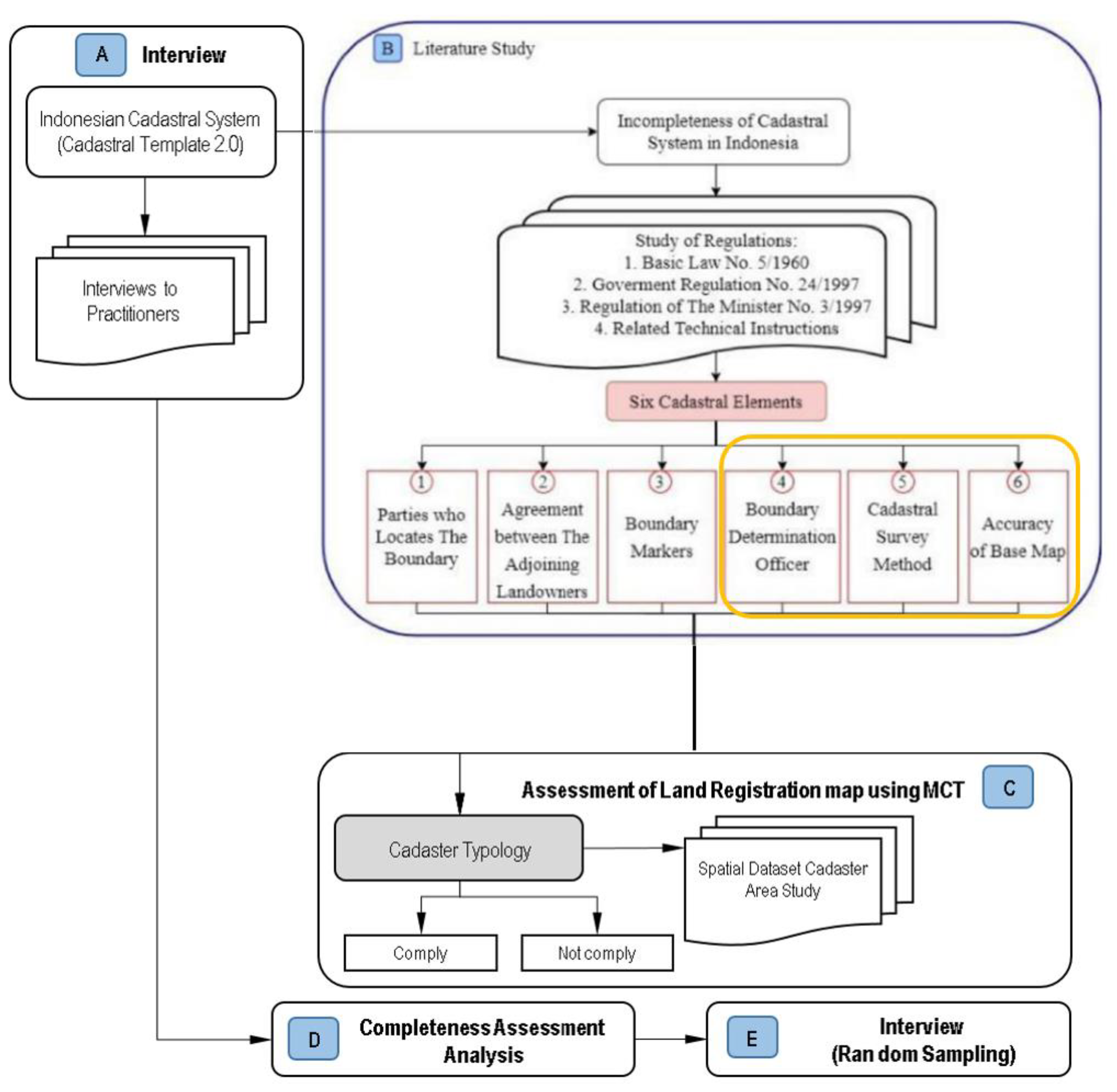
12]. Field data collection was carried out in urban areas (Pluit and Lagoa Wards, North Jakarta Administrative City). The methodology used in this study is a qualitative method. Briefly, the research workflow as referred in
Figure 1, carried out in the following stages:
- (a)
Interviews with policymakers to identify the cadastre system in Indonesia. The interview material is guided by the Cadastral Template 2.0 questionnaire developed by the University of Melbourne, Australia (Box A) [
13];
- (b)
Regulatory studies, namely laws, government regulations, ATR/BPN Ministerial Regulations, and implementation instructions in order to formulate the cadastre elements specified in the boundary determination in Indonesia (Box B);
- (c)
Cadastre typology forming as an indicator of the level of quantitative conformity with land parcel maps using tools on geographic information system software (Box C);
- (d)
Analysis of the causes of cadastre in the study area is still incomplete based on the results of interviews (Box D); and
- (e)
Random interviews with certificate recipients and officials in the Survey and Mapping Section of the North Jakarta Administrative City Land Office in areas of study to confirm the analysis results (Box E).
Currently, there is no specific terminology related to cadastre typology. However, in this study, cadastre typology can be defined as a method used to classify cadastre element variables into a group of objects based on their similarity in order to obtain a quantitative analysis of cadastre typology.
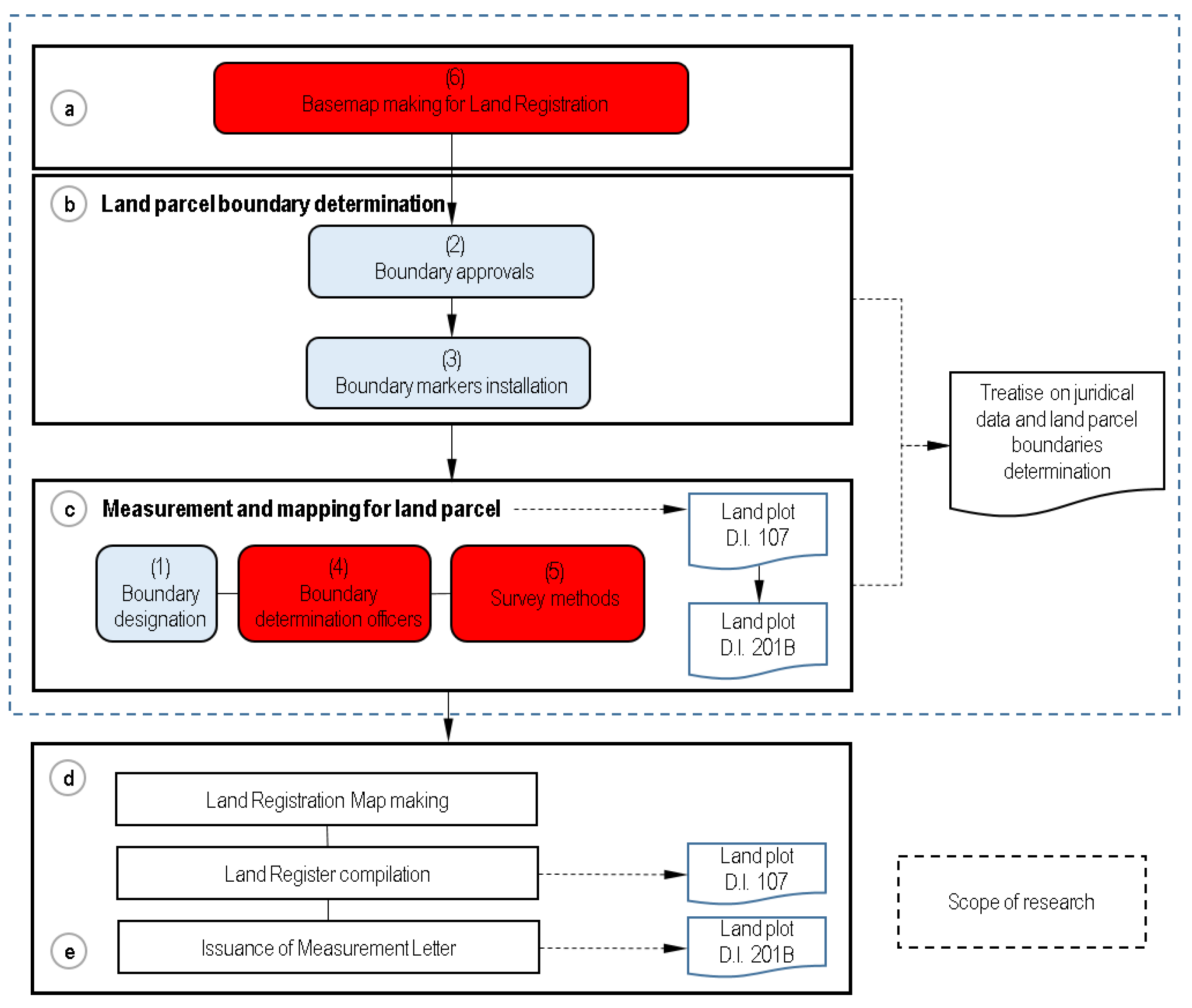
Boundaries determination in land registration regulations in Indonesia is a legal or juridical activity, which is stated in the registration form (DI) 201, namely the Juridical Data Research Minutes and Boundary Determination. By the provisions of PMNA No. 3/1997 Article 140, DI types can be seen from the numbering, a) DI which the numbering begins with the number 2 in the registration form means describing the part of the juridical data, b) DI which begins with the number 1 indicates technical data, then c) DI that begins with number 3 means for administrative data [
14]. However, the boundary determination activity stages consist of legal and spatial elements, as shown in
Figure 2. Six cadastral elements were obtained from a literature study on legal (including laws and regulations) governing measurement and mapping, particularly criteria stated in Regulation of the Minister of Agrarian (PMNA) Technical Guidelines 3/1997 Articles 17 to 24 [
14]. The classification of cadastre typology proposed by Arruñada (2018), in this study can be grouped into six cadastral elements, which are: legal elements (parties who locate the boundary, boundary agreements, and boundary markings) and spatial elements (boundary determination survey, measurement methods, and base map accuracy) [
6]. Here, boundary determination survey is the term that used to specify activities involving cadastral surveyors and boundary determination activities in the field. Legal elements are represented by blue boxes (1 to 3) and spatial elements by red boxes (4 to 6). Only spatial elements will be used to conduct assessments in this study (
Table 2). To evaluate the compliance of spatial cadastral elements dataset in the study area to the regulation, this study uses the binomial number 1 for “comply,” and 0 for “not comply”. In order to classify the compliance levels of each spatial cadastre elements, this study used tools from geographic information systems software.
The measurement of land parcels using the terrestrial method can be carried out using the offset and polar methods. The choice depends on which approach is more practical to use, the field conditions, and additional requirements for obtaining data. Cadastral survey and data collection for sporadic and systematic land registration for getting data to provide complete land parcels information. Each plot can be mapped according to its shape and size in the field. It is forbidden to force the drawing of the plot with an approximate distance or direction. Therefore, additional measurements must be taken to evaluate the calculation. In determining each boundary point, a minimum of 3 (three) data sizes is required and measured using a minimum of 2 (two) fixed/reference points [
14]. The planimetric accuracy for a land parcel map must be larger than or equal to 0.3 mm at map scale [
14], equivalent to 30 cm for a 1:1000-scale map (for settlement areas) or 75 cm for a 1:2500-scale map (for agricultural areas) according to the national base map accuracy standards released by Indonesia Geospatial Information Agency.
Table 3 corresponds to the compliance of the six cadastral elements at the study location of two urban wards in the North Jakarta Administrative City. The first number in the last three digits is the level of compliance of boundary determination surveyors; the following number is the second spatial element, which is measurement methods. The last digit is the base map accuracy. The first three digits which indicates three passive values of legal elements, were not assessed. Therefore, the given score was 1.
An assessment of the compliance level of spatial elements was carried out on 19,173 land parcel maps in two sub-districts (Pluit and Lagoa) of North Jakarta Administrative City. It resulted in a cadastral typology, as shown in
Table 3.
Each of the land parcels in the study area were assessed to value their cadastre typology compliance in regard to spatial elements. Activities to determine the valuation of red boxes of 4, 5, and 6 in ` were conducted for each and every land parcel. From these assessments, the percentage of compliance level can be determined.
The percentage of compliance level regarding cadastre elements that meet the technical requirements is calculated using the following equation:
Explanation:
% Compliance: level of compliance compared with the regulation (%)
Σ Comply: the number of elements cadastre that meet the technical requirements
3. Results
The results presented here are organized as a following structure: results from interview (Box A in
Figure 1) are presented in
Section 3.1, results from regulatory studies (Box B) are presented in
Section 3.2., while
Section 3.3. presented the results from assessment, analysis and validation of the research (Box C, Box D and Box E in
Figure 1).
3.1. Indonesian Cadastral System
The cadastral system that applies in Indonesia is described in the cadastral template 2.0 (
http://cadastraltemplate.org/indonesia.php accessed on 2 May 2021) [
16]. However, the data has not been updated since 15 June 2003. Based on literature reviews and interviews conducted, the cadastral system in Indonesia is implemented through land registration to ensure legal certainty of land rights (land tenure) and facilitate their transfer, provide information, and orderly land administration. The type of land registration used in Indonesia is title registration, not deed registration. Land registration is implemented nationally through a systematic or sporadic approach. Based on a legal perspective, systematic land registration is compulsory, as well as data maintenance. At the same time, sporadic land registration activities are optional. The central cadastral unit is a land parcel marked with boundaries and surveyed, with spatial data in the form of geospatial information regarding the location, borders, and area. Thus, the cadastre’s two main contents: spatial data (physical data) and legal (juridical data). To present this data, the land office located in each district/city maintains a general register consisting of a registration map (cadastre map), a land register, a certificate of measurement, a land book, and a list of names.
A cadastre map is made based on a base map that has a scale of 1:1000 or higher for urban areas, 1:2500 or higher for agricultural areas, and 1:10,000 or less for large plantation areas. In addition, cadastre maps are often visualized with other thematic geospatial information (IGT), such as spatial plans, land value zones, forest areas, raw rice fields (
https://bhumi.atrbpn.go.id/ - accessed on 1 December 2021).
In most developing countries, the spatial cadastral layers have not yet been integrated with other spatial data such as e-Government, community empowerment, and other activities to achieve sustainable development [
17]. The role of the spatial cadastre in many administrative areas in Indonesia is still limited to the service of land tenure and control functions. However, Indonesia is starting to improve spatial cadastre data usages. One of the best examples of spatial cadastre usage and integration is DKI Jakarta Province which has shared IGT data through Jakarta Satu portal (
https://jakartasatu.jakarta.go.id/portal/apps/sites/#/public - accessed on 1 December 2021). The main problem that causes Indonesia not to make the spatial cadastre the engine of the current land administration system is the incompleteness of the data and the quality of the cadastre content. Since 2017, the Indonesian government has launched a complete and systematic land registration (PTSL) program to accelerate land registration; Presidential Instruction Number 2/2018, enacted to ensure the acceleration [
18]. There are four classes of land parcels in PTSL: land parcels that have been registered but have not been mapped (K4), land parcels that are not disputed but not ready for certification (K3), disputed land parcels (K2), and land parcels that are not disputed and prepared for certification (K1). K4 means that the land office needs to take action to improve the quality of land registration data. K4 becomes an outcome because of “floating certificates,” land rights that are not mapped correctly or without spatial information.
In addition to PTSL, the government has taken new initiatives in the form of digital transformation. Computerization is carried out in stages, both in the form of document scans and fully digital. However, several challenges still need to be resolved in the digital transformation of cadastre content. First, not all cadastral content has been entirely entered into the KKP. Second, the data quality is not wholly “valid” according to the contents recorded in the analog document. The problem is related to various factors, mainly caused by incomplete or incorrect analog data, data entry errors, double numbering. Therefore, the conformity status of electronic data with analog data for each field needs to be validated. Third, there are two spatial cadastre data groups: unmapped registered areas (called KW 4, 5, 6) and mapped (called KW 1, 2, 3). The quality of the spatial cadastre data of KW 1, 2, 3 differs in the level of accuracy/uncertainty, both relative and positional.
3.2. Spatial Cadastre Elements
A spatial cadastre in the form of a registration map describing plots of land for recording/bookkeeping. This study distinguishes between spatial elements and legal elements in the delimitation process, as Arruñada (2018) stated [
6]. Fixed boundaries are mandatory through boundary-determination activities. Boundary determination activities are not only part of the technical activities of surveys and mapping. Still, they are part of the legal activities outlined in DI 201, namely the Minutes of Boundary Determination and Juridical Data Research. Articles 14 to 22 of Government Regulation No. 24/1997, six cadastral elements are mentioned in cadastral boundary determination activities, namely, the party indicating the boundary, agreement with adjacent landowners, boundary marking, boundary delimitation surveyor, cadastral survey method, and base map accuracy (see
Figure 2 and
Figure 3) [
15].
3.3. Assessment and Analysis of Indonesian Cadastre Incompleteness
Multivariate clustered land parcels downloaded from the KKP are used to identify the grouping of land parcels into a cadastral typology. Based on the resulting clustering map, the measurement results appear to comply with the three spatial cadastral elements and those that do not comply with regulations that must be improved in quality. The results of the cadastral typology of 19,172 plots of land in the study area can be seen in
Table 4 below. This study’s analysis of the three spatial elements resulted in two cadastral typologies, as shown in
Table 3.
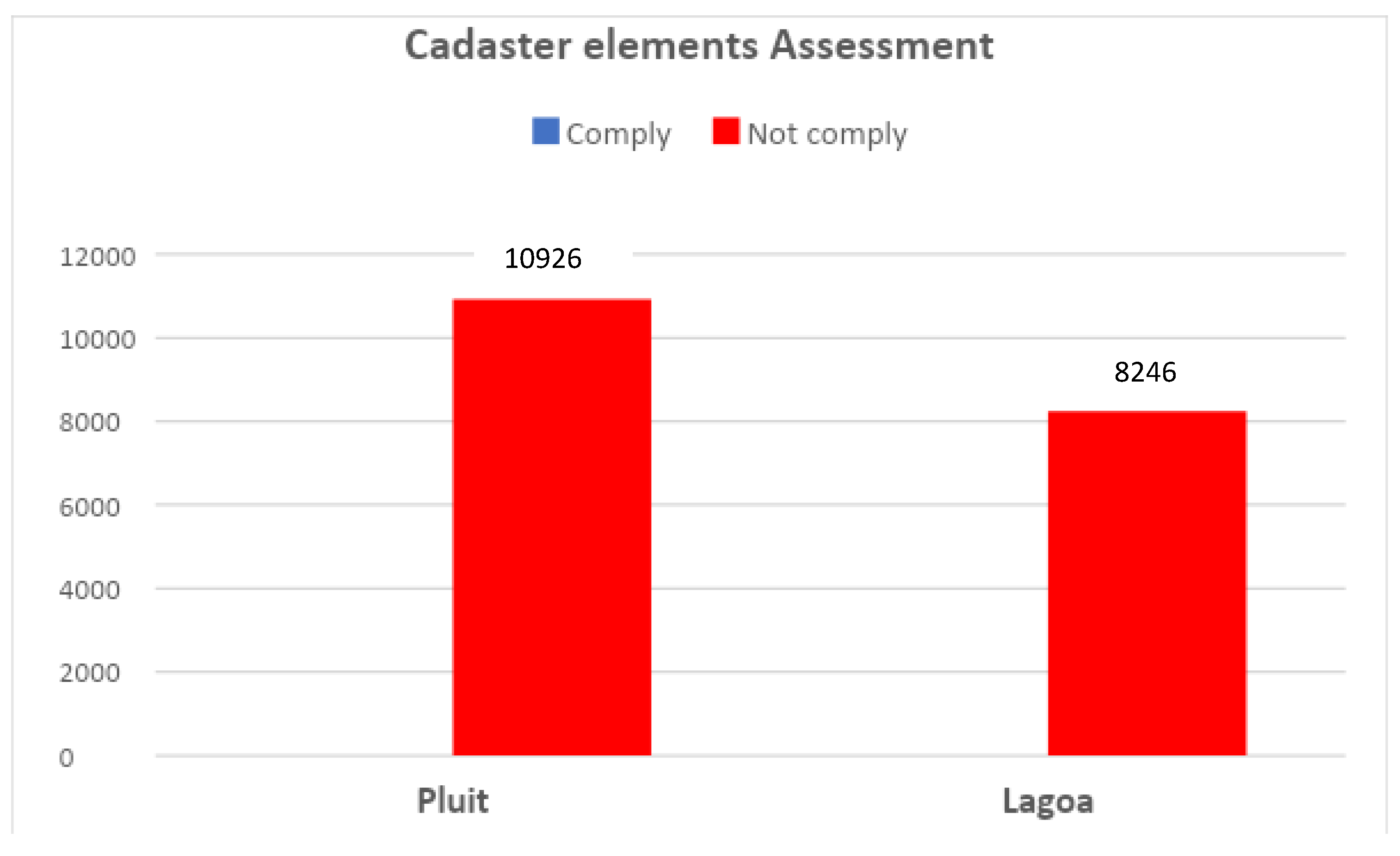
The assessment results, as shown in
Figure 3 show that 100% of the spatial cadastral elements in the two study areas do not meet the survey and mapping rules stipulated in the PMNA Technical Instructions Regulation No. 3/1997 on Materials for Measurement and Mapping of Land Registration [
14].
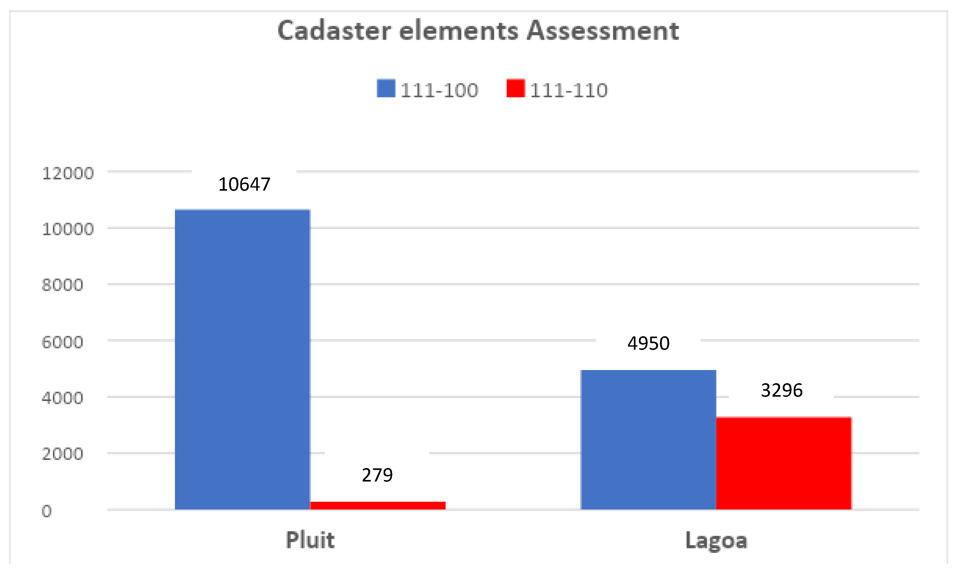
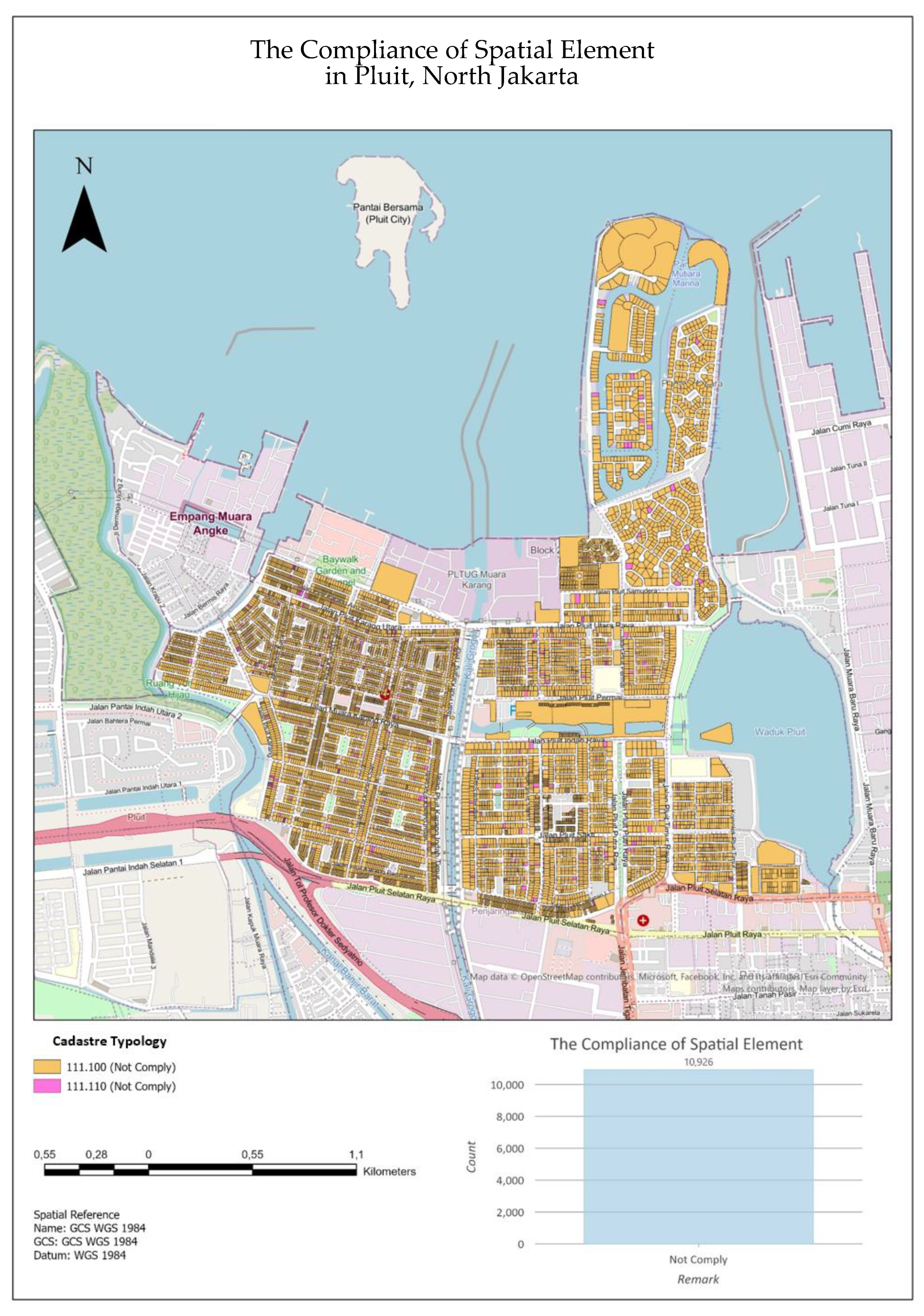
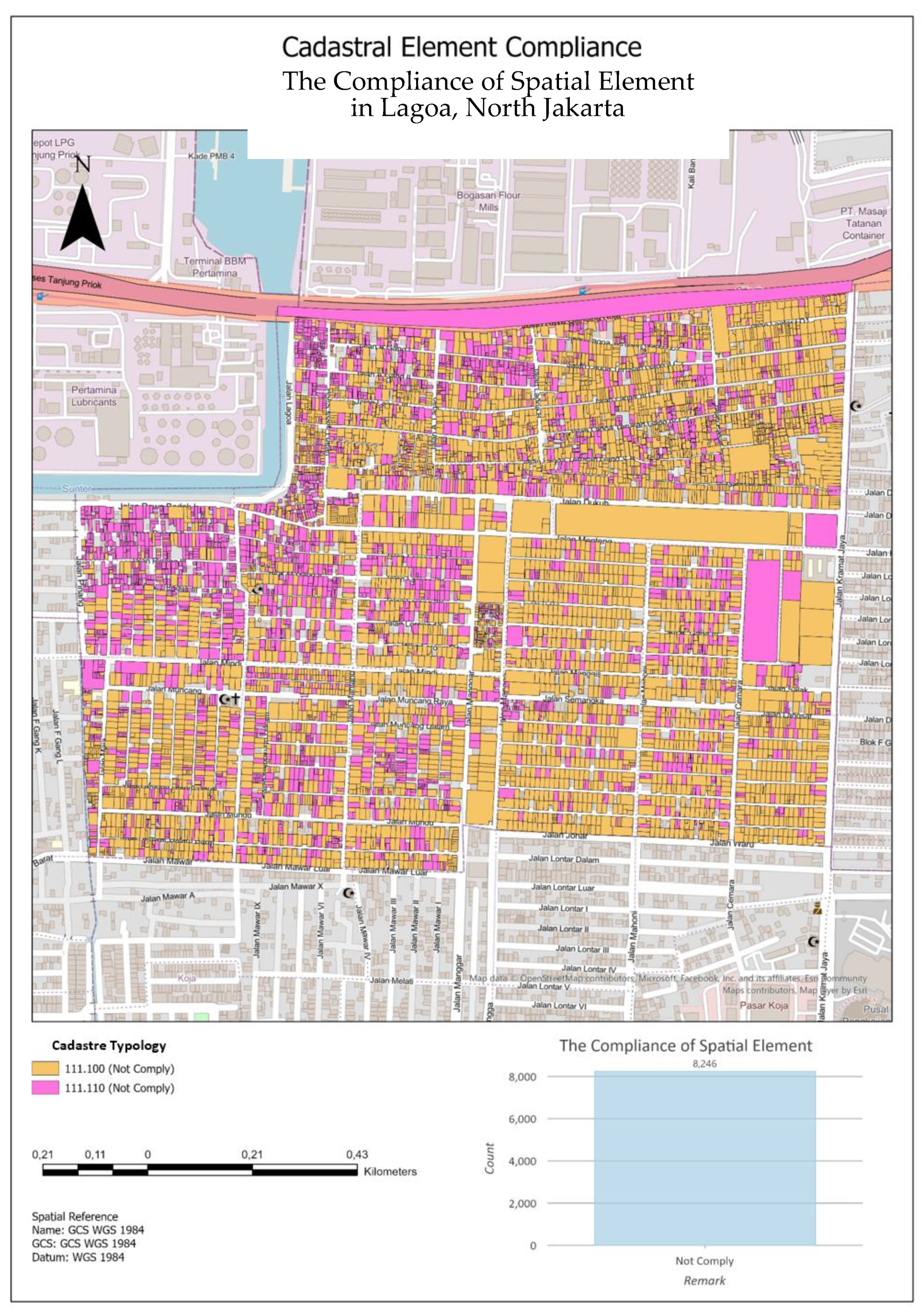
The cadastre typology of Pluit and Lagoa Wards can be seen in
Figure 4. A score of “0” in the fifth digit indicates that the cadastral element of the measurement method used is the terrestrial method without further measurement and does not include the level of distance accuracy, which means that it does not follow the technical instructions that have been set. The results of the spatial assessment in the form of cadastral typology can be seen in
Appendix A and
Appendix B. The dataset of spatial cadastral elements in the two wards can be seen in
Table 5.
3.3.1. Boundary Determination Surveyors
An assessment of the element of boundary delimitation officers showed that 100% (19,172) of the plots of land mapped in Pluit and Lagoa wards were carried out by ASN surveyors. However, based on GU and SU data assessment and interviews with the Head of the Survey and Mapping Section, there was no involvement from licensed surveyors or outside parties in determining the boundaries because all land parcels were measured independently.
The involvement of the private sector in cadastral surveys is carried out through a licensed cadastral surveyor who has a permit (SKB) and is issued by the Minister of ATR/Head of BPN. Data per March 2020 shows that there are 13,216 SKB which consist of 2275 Cadastre Surveyors (SK) and 10,941 Assistant Cadastre Surveyors (ASK). In order to accelerate systematic land registration, the addition of SKB is needed. Ideally, the number of surveyors is still increased. Approximately 40,000 surveyors and more than 30 universities are required to develop land registrations that support a modern land administration system, such as Australia [
19].
3.3.2. Measurement Method
Assessment of the measurement method elements used in the Pluit Ward, 100% (10,926) of the registered fields were measured using the terrestrial measurement method (measuring tape, TS). Meanwhile, in Lagoa Ward, 60% (4950) of land parcels were measured using the terrestrial method (tape, TS), and 40% (3296) of registered land parcels were measured using the satellite observation method (GPS/GNSS/CORS). The results of the measurement data verification show that all measurement results using the terrestrial method have no excess measurements and tolerance values, so a value of 0 (does not meet) is given.
Based on interviews with the Head of the Survey and Mapping Section, the measurement method used in the two sub-districts of the study area after 2017 was the terrestrial method using Total Station and roll meter tools. In addition, it also uses the satellite observation method using GPS/GNSS/CORS. Still, the mapping activities use a base map on the KKP application that does not meet the basic map accuracy requirements below.
3.3.3. Base Map Accuracy
The assessment of the accuracy of the base map used shows that 100% (19,172) of registered land parcels in Pluit and Lagoa Wards use a base map. Still, the base map does not meet the planimetric accuracy according to the technical instructions.
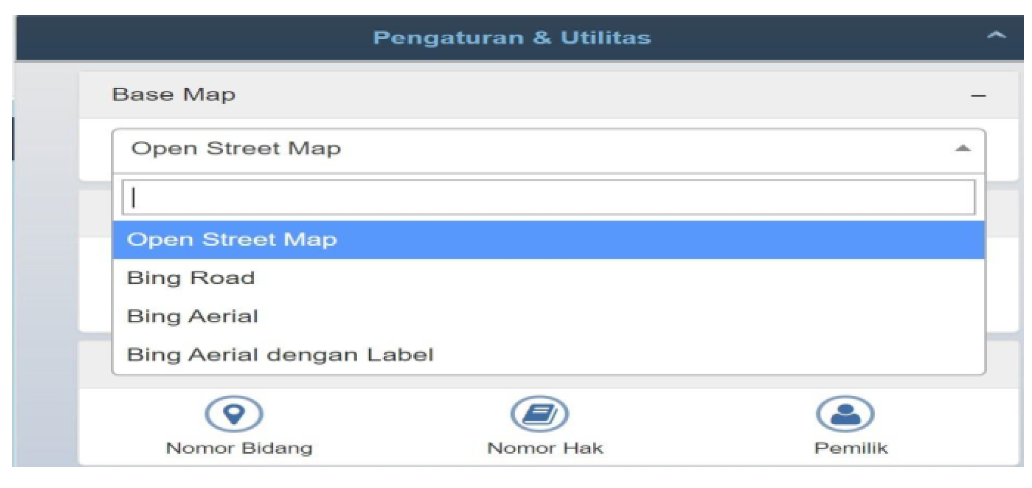
Figure 5 shows that the base maps available in the KKP application for the DKI Jakarta area are Open Street Map, Bing Road, Bing Aerial, and Bing Aerial with Labels. All of these base maps have not yet been geo-orthorectified.
4. Discussion
The Indonesian cadastral content is mentioned in Government Regulation (PP) No. 24/1997 as a general list consisting of a land book, a measurement certificate, a land register, a list of names, and a registration map [
15]. Following the division of objectives and outcomes of the CRSBANZ (Council of Reciprocating Surveyors Boards of Australia and New Zealand) cadastral surveys [
7], the general list consists of two categories that have interrelated outcomes. The first outcome is the legal area of land parcels, which will later be used to determine Rights, Restrictions, and Responsibilities (RRRs) [
20], and is attached in the land book, certificate of measurement, name register, and land register. The second outcome is the spatial cadastre (which is later being used as spatial representation in the registration map. The first outcome is the administrative source for providing certainty by the law overland rights on a specific land plot.
An assessment of the quality of the second outcome using multivariate clustering in the two study areas shows the existence of cadastral land parcel maps (PBT), both from the results of systematic and sporadic land registrations that do not meet cadastral regulations in Indonesia. These empirical results require re-measurement and mapping of fields or modifying fit-for-purpose regulations by defining the goals and outcomes of the cadastral survey to be addressed by the cadastral system in Indonesia. A typical roadmap for accuracy improvements as presented in
Table 1 (with some simplifications or customization to accommodate Indonesia’s cadastral map challenges) may be required. Regulatory modifications are also needed to accommodate the concept of standardizing land related data to comply with LADM requirements [
8] to facilitate registration maps as a second outcome that requires technology to be shared with other institutions. The first step that can be taken into consideration is to create a cadastral typology of all produced PBT to identify their level of conformity to the regulation. The cadastre typology shows which cadastral elements are appropriate or not and which are required to be improved to comply with the regulation.


