
A Synthesis of Land Use/Land Cover Studies: Definitions, Classification Systems, Meta-Studies, Challenges and Knowledge Gaps on a Global Landscape


Abstract
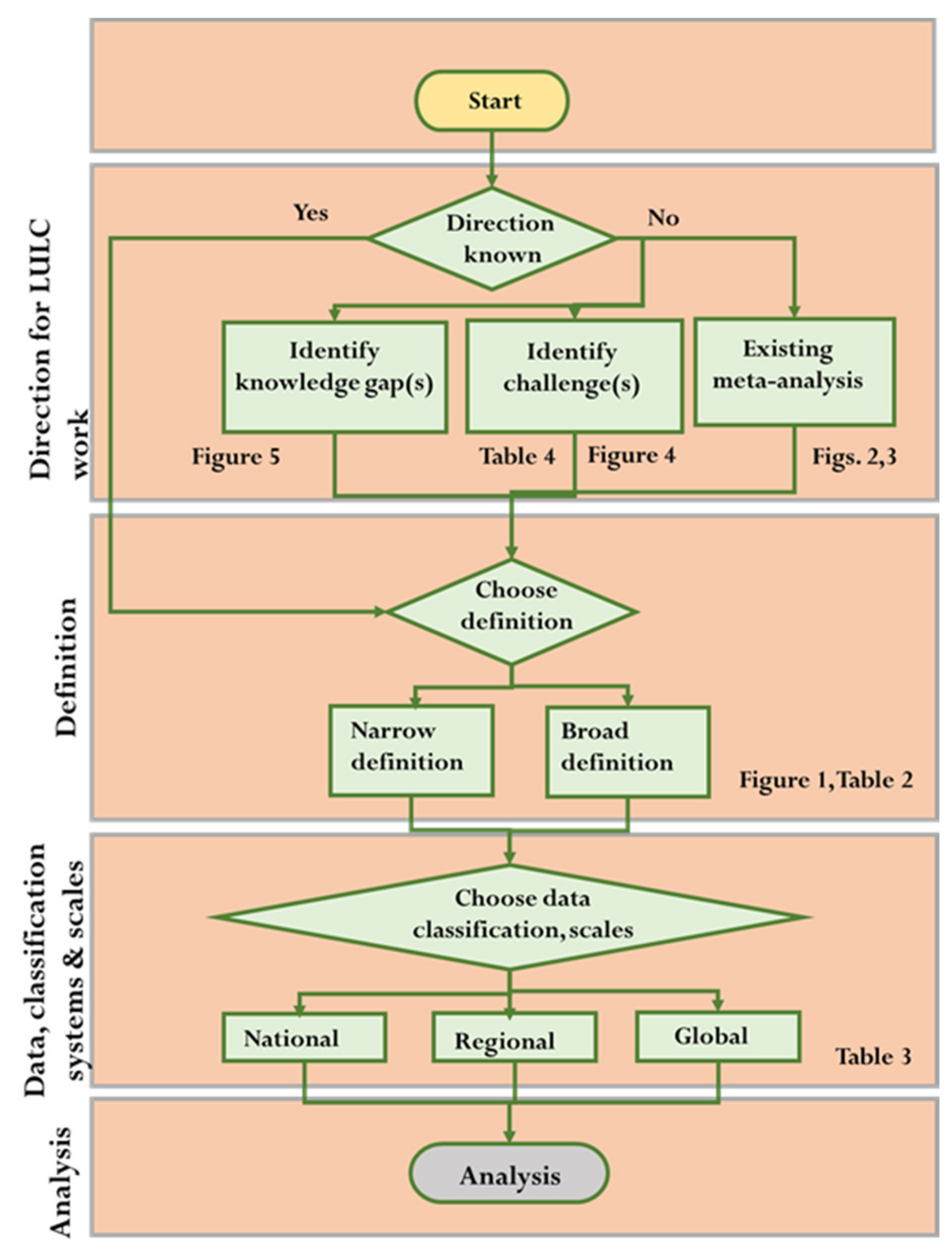
:1. Introduction
- Land use/land cover definitions and how the various authors define them.
- The use of land use/land cover classification systems and how they are used by countries, regionally and on a global scale.
- Land use/land cover meta-analysis studies in the areas of direct and indirect LULC, as well as data and methods of change.
- Associated challenges correlated to land use/land cover changes.
- Knowledge gaps and needs associated with land use/land cover change.
2. Methodology
2.1. The Steps Used According to the PSALSAR Framework for Collecting and Synthesizing Land Use/Land Cover Definitions for This Literature Review
- The defined scope and terms “land use and land cover definitions” was used as the keywords as part of the search strategy.
- A total of thirty-five (35) articles on “land use and land cover definitions” were downloaded based on the terms.
- “Backward and forward snowball” sampling for a further thirteen (13) research articles based on the terms “land use/land cover definitions”.
- Thirty (30) articles for “land use and land cover definitions” were selected and appraised for information.
- The definitions were synthesized and placed into a table template, separated into two categories: land use and land cover.
- The definitions were divided by regions where the specific authors did research.
2.2. The Steps Used According to the PSALSAR Framework for Collecting and Synthesizing Land Use/Land Cover Classification System Used for This Literature Review Worldwide
- The defined scope and terms “land use and land cover classification systems” was used as the keywords as part of the search strategy.
- A total of two hundred and thirty-three (233) articles on “land use/land cover classification systems” were downloaded for information.
- One hundred and seventy-one (171) articles on “land use/land cover classification systems” were selected based on their relevance.
- Sixty-two (62) articles were reviewed and appraised for “land use/land cover classification systems” information based on classification systems.
- Twelve (12) articles were synthesized and placed into a table template for “land use/land cover classification systems”.
- The table contains three categories (national, regional, and global) and shows classification systems used by various countries.
2.3. The Steps Used According to the PSALSAR Framework for Collecting and Synthesizing Land Use/Land Cover Meta-Analysis Studies for (1) Direct Changes in LULC; (2) Indirect Changes in LULC and; (3) Meta-Studies of Data/Methods
- The defined scope and terms “land use and land cover meta-analysis” was used as the keywords for the search strategy in the search engines.
- A total of fifty-five (55) articles were downloaded for information on “land use/land cover meta-analysis”.
- To conduct the “land use/land cover meta-analysis”, forty-eight (48) articles were selected and appraised.
- Three categories: Direct, indirect, and data/methods associated with “land use/land cover meta-analysis” were used to present the papers in figures.
2.4. The Steps Used According to the PSALSAR Framework in Synthesizing Associated Challenges Correlated to Land Use/Land Cover Changes
- The defined scope and terms “land use and land cover challenges” was used as the keywords as part of the search strategy.
- A total of thirty-five (35) articles were downloaded on “land use/land cover challenges” for information.
- Twenty-nine (29) papers were selected and appraised for information related to “land use/land cover challenges”.
- Two categories: Data quality and data consistency on “land use/land cover challenges”, were used for the paper and presented in a table.
2.5. The Steps Used According to the PSALSAR Framework in Synthesizing Knowledge Gaps and Needs Associated with Land Use/Land Cover Change
- The defined scope and terms “land use/land cover knowledge gaps and needs” were used for land use/land cover,
- A total of thirty-one (31) articles were downloaded on “land use/land cover knowledge gaps and needs” for information,
- Twenty-seven (27) articles were selected and appraised for information “land use/land cover knowledge gaps and needs”,
- “Land use/land cover knowledge gaps and needs” were identified and placed into four categories related to LULC, namely ecosystem services, forestry, data, and modeling.
3. Results
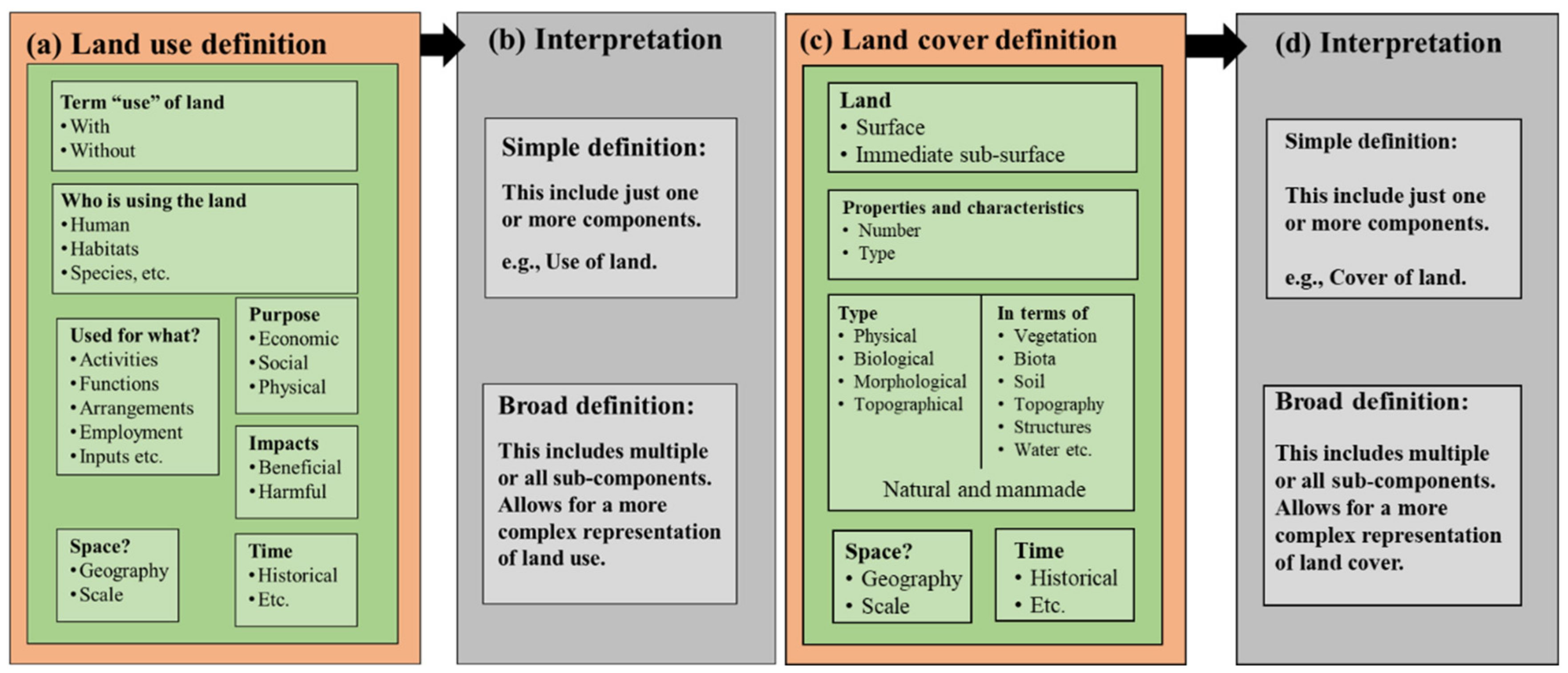
3.1. Land Use/Land Cover Definitions
- Most of the definitions have the word “use” while describing the term. However, Anderson et al. (1976) defined land use as “Man’s activities on land which are directly related to the land” [4], while Sreedhar et al. (2016) describe it as “Human activity or economic functions associated with a specific geography” [20]. These definitions do not have the term “use”.
- Definitions often include the activities or functions related to the use of land. Additionally, terms such as arrangements and inputs have been used in describing this component. Further, the employment of land is used in descriptions by social scientists [10]. In some cases, this component precisely defines the purpose of these activities, such as economic, social, and physical reasons.
- Definitions can describe the effect of these activities. Additionally, beneficial or harmful impacts of the changes in the land are included in these interpretations.
- A few of the definitions have a time component in them. Terms such as historical are associated with this component [30].
3.2. Land Use/Land Cover Classification System Used Worldwide
3.2.1. Classification Systems
3.2.2. National Classification System
3.2.3. Regional Classification Systems
3.2.4. Global Classification System
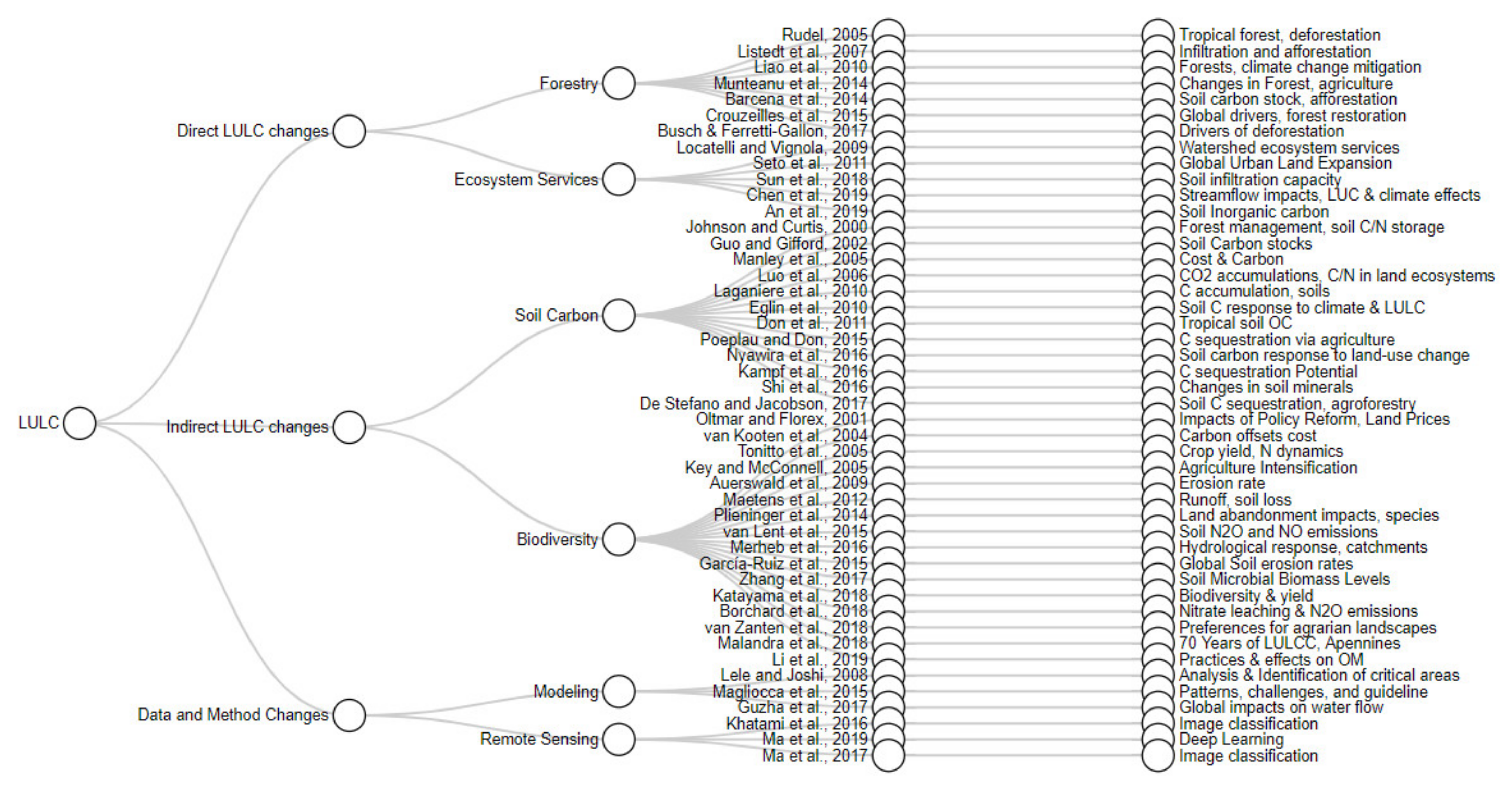
3.3. Synthesis of Meta-Analysis Studies in LULC
3.3.1. Meta-Analysis Related to Direct Changes in LULC (Forest)
3.3.2. Meta-Analysis Related to Indirect Changes in LULC (Climate Change)
3.3.3. Meta-Analysis Related to Data and Methods
3.4. Land Use/Land Cover Associated Challenges
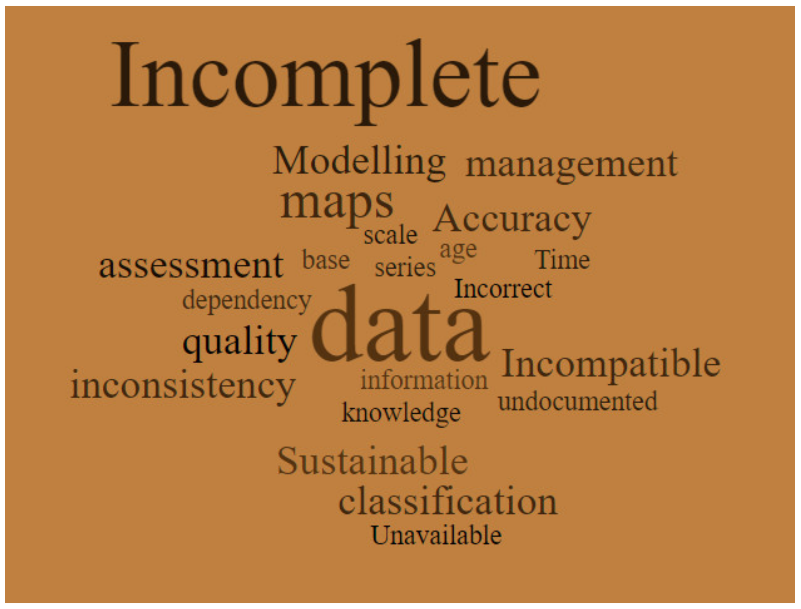
3.4.1. Data Quality
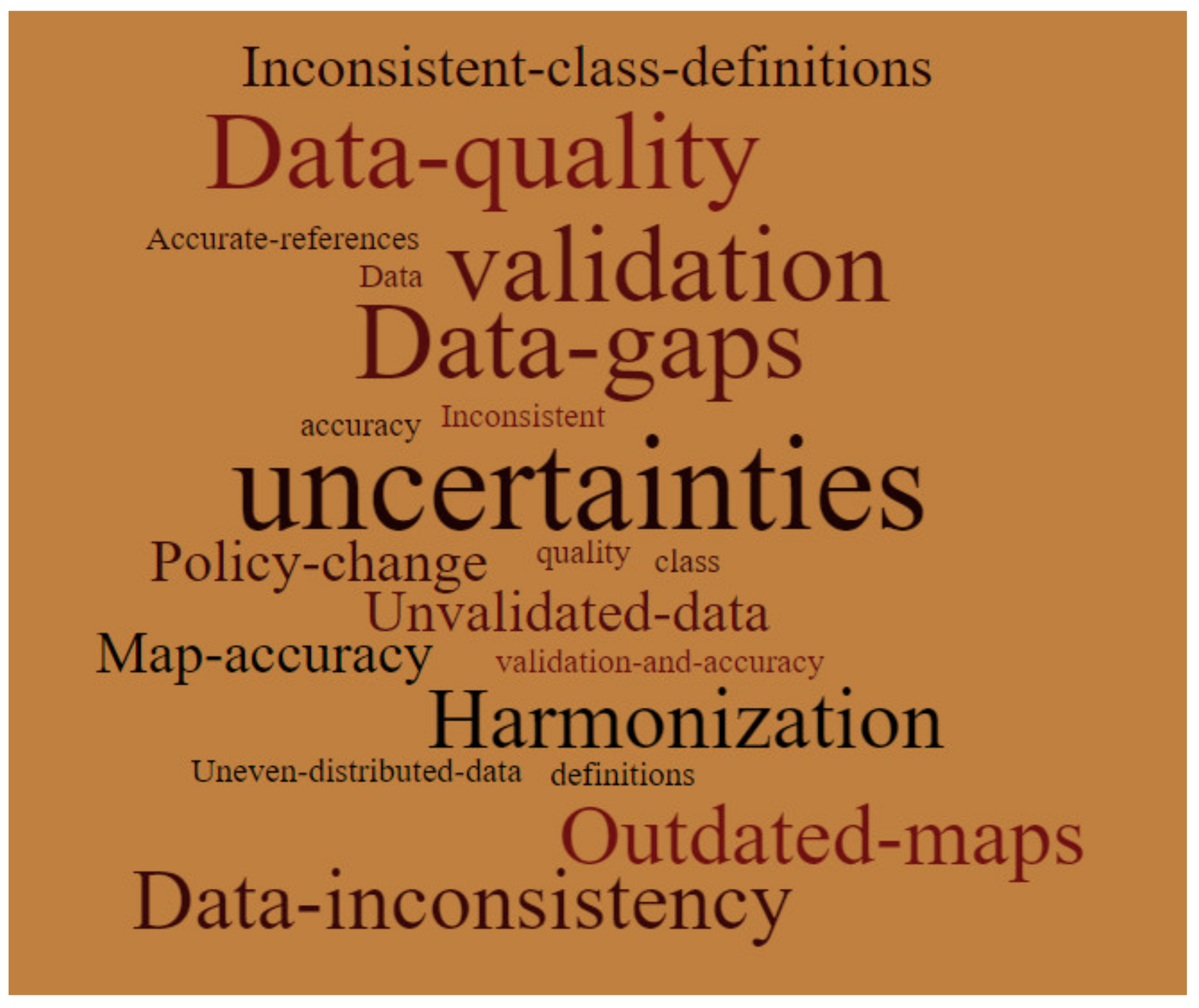
3.4.2. Data Consistency
3.5. Land Use/Land Cover Knowledge Gaps
3.5.1. Ecosystem Services
3.5.2. Forestry
3.5.3. Data/Images/Modeling
- The general need for:
- Accurate statistical testing;
- Identical land-cover configurations;
- Reduction of model uncertainty;
- Clear experimental protocols [151].
- Systematic monitoring and management of land use systems [38].
- Automating image classification processes for accessible data and processing results in a shorter time [35].
- The assessment of the performance and sensitivities in LULC classification algorithms [111].
- Improve accuracy, eliminate uncertainties and discrepancies in the spatio-temporal changes [60].
- Consistency and comparability of different land cover maps, understanding their suitability and limitations for specific applications [152].
- Detailed datasets for environmental change studies, resource management, climate modeling, and sustainable development of terrestrial land cover are needed [62].
- Available data for modeling the advancement and collection of new datasets are needed [8].
3.5.4. Hydrology
4. Discussion
4.1. Land Use and Land Cover Definition
4.2. Land Use and Land Cover Classification System
4.3. Land Use and Land Cover Meta-Analysis
4.4. Land Use and Land Cover Challenges
4.5. Land Use and Land Cover Knowledge Gaps
5. Conclusions
Author Contributions
Funding
Institutional Review Board Statement
Informed Consent Statement
Data Availability Statement
Acknowledgments
Conflicts of Interest
References
- Keil, A. OpenStreetMap Land Classification System (OSM-LCS). 2016. Available online: https://labor.beuth-hochschule.de/fileadmin/labor/gem/arbeiten/Keil_Master_Arbeit.pdf (accessed on 17 September 2021).
- Meyfroidt, P.; Roy Chowdhury, R.; de Bremond, A.; Ellis, E.C.; Erb, K.-H.; Filatova, T.; Garrett, R.D.; Grove, J.M.; Heinimann, A.; Kuemmerle, T.; et al. Middle-Range Theories of Land System Change. Glob. Environ. Chang. 2018, 53, 52–67. [Google Scholar] [CrossRef]
- Anandhi, A.; Douglas-Mankin, K.R.; Srivastava, P.; Aiken, R.M.; Senay, G.; Leung, L.R.; Chaubey, I. DPSIR-ESA Vulnerability Assessment (DEVA) Framework: Synthesis, Foundational Overview, and Expert Case Studies. Trans. ASABE 2020, 63, 741–752. [Google Scholar] [CrossRef]
- Anderson, J.R. A Land Use and Land Cover Classification System for Use with Remote Sensor Data; U.S. Government Printing Office: Washington, DC, USA, 1976.
- Erb, K.-H.; Luyssaert, S.; Meyfroidt, P.; Pongratz, J.; Don, A.; Kloster, S.; Kuemmerle, T.; Fetzel, T.; Fuchs, R.; Herold, M.; et al. Land Management: Data Availability and Process Understanding for Global Change Studies. Glob. Chang. Biol. 2017, 23, 512–533. [Google Scholar] [CrossRef] [PubMed] [Green Version]
- Ran, Y.H.; Li, X.; Lu, L.; Li, Z.Y. Large-Scale Land Cover Mapping with the Integration of Multi-Source Information Based on the Dempster–Shafer Theory. Int. J. Geogr. Inf. Sci. 2012, 26, 169–191. [Google Scholar] [CrossRef]
- Luyssaert, S.; Jammet, M.; Stoy, P.C.; Estel, S.; Pongratz, J.; Ceschia, E.; Churkina, G.; Don, A.; Erb, K.; Ferlicoq, M.; et al. Land Management and Land-Cover Change Have Impacts of Similar Magnitude on Surface Temperature. Nat. Clim. Chang. 2014, 4, 389–393. [Google Scholar] [CrossRef] [Green Version]
- Pongratz, J.; Dolman, H.; Don, A.; Erb, K.-H.; Fuchs, R.; Herold, M.; Jones, C.; Kuemmerle, T.; Luyssaert, S.; Meyfroidt, P.; et al. Models Meet Data: Challenges and Opportunities in Implementing Land Management in Earth System Models. Glob. Chang. Biol. 2018, 24, 1470–1487. [Google Scholar] [CrossRef] [Green Version]
- Jansen, L.J.M.; Gregorio, A.D. Parametric Land Cover and Land-Use Classifications as Tools for Environmental Change Detection. Agric. Ecosyst. Environ. 2002, 91, 89–100. [Google Scholar] [CrossRef]
- Meyer, W.B.; Turner, B.L. Human Population Growth and Global Land-Use/Cover Change. Annu. Rev. Ecol. Syst. 1992, 23, 39–61. [Google Scholar] [CrossRef]
- Gregorio, A.D.; Jansen, L.J.M. A New Concept for a Land Cover Classification System. Land 1998, 2, 55–65. [Google Scholar]
- Lambin, E.F.; Rounsevell, M.D.A.; Geist, H.J. Are Agricultural Land-Use Models Able to Predict Changes in Land-Use Intensity? Agric. Ecosyst. Environ. 2000, 82, 321–331. [Google Scholar] [CrossRef]
- Verburg, P.H.; Neumann, K.; Nol, L. Challenges in Using Land Use and Land Cover Data for Global Change Studies: Land Use and Land Cover Data For Global Change Studies. Glob. Chang. Biol. 2011, 17, 974–989. [Google Scholar] [CrossRef] [Green Version]
- Pradeep Kumar, B.; Raghu Babu, K.; Rajasekhar, M.; Ramachandra, M. Change Detection of Land Use/Land Cover Using Geospatial Techniques: A Case Study of Narpala Mandal, Anantapur District, Andhra Pradesh, IndiâPradeep. J. Remote Sens. GIS 2019, 10, 6–12. [Google Scholar]
- Ellis, E.; Pontius, R. Land-Use and Land-Cover Change—Encyclopedia of Earth. Available online: https://web.archive.org/web/20070503192914/http://www.eoearth.org/article/Land-use_and_land-cover_change (accessed on 12 November 2020).
- United Nations SDG Indicators. Available online: https://unstats.un.org/sdgs/report/2020/ (accessed on 17 November 2020).
- US EPA. Land Use. Available online: https://www.epa.gov/report-environment/land-use (accessed on 17 November 2020).
- Dimyati, M.; Mizuno, K.; Kobayashi, S.; Kitamura, T. An Analysis of Land Use/Cover Change in Indonesia. Int. J. Remote Sens. 1996, 17, 931–944. [Google Scholar] [CrossRef]
- Singh, R.K.; Sinha, V.S.P.; Joshi, P.K.; Kumar, M. A Multinomial Logistic Model-Based Land Use and Land Cover Classification for the South Asian Association for Regional Cooperation Nations Using Moderate Resolution Imaging Spectroradiometer Product. Environ. Dev. Sustain. 2020, 23, 6106–6127. [Google Scholar] [CrossRef]
- Sreedhar, Y.; Nagaraju, A.; Murali Krishna, G. An Appraisal of Land Use/Land Cover Change Scenario of Tummalapalle, Cuddapah Region, India—A Remote Sensing and GIS Perspective. Adv. Remote Sens. 2016, 5, 232–245. [Google Scholar] [CrossRef] [Green Version]
- Duhamel, C. Duhamel Land Use and Land Cover, Including Their Classification. Encylopedia Life Support Syst. 2012, 1, 9. [Google Scholar]
- Herold, M.; Latham, J.S.; Di Gregorio, A.; Schmullius, C.C. Evolving Standards in Land Cover Characterization. J. Land Use Sci. 2006, 1, 157–168. [Google Scholar] [CrossRef] [Green Version]
- Borenstein, M.; Hedges, L.V.; Higgins, J.P.T.; Rothstein, H.R. Introduction to Meta-Analysis; John Wiley & Sons: Hoboken, NJ, USA, 2011; ISBN 978-1-119-96437-7. [Google Scholar]
- De Stefano, A.; Jacobson, M.G. Soil Carbon Sequestration in Agroforestry Systems: A Meta-Analysis. Agrofor. Syst. 2017, 92, 285–299. [Google Scholar] [CrossRef]
- Mengist, W.; Soromessa, T.; Legese, G. Method for Conducting Systematic Literature Review and Meta-Analysis for Environmental Science Research. MethodsX 2020, 7, 100777. [Google Scholar] [CrossRef] [PubMed]
- Mohd Hasmadi, I.; Pakhriazad, H.Z.; Shahrin, M.F. Evaluating Supervised and Unsupervised Techniques for Land Cover Mapping Using Remote Sensing Data. Geogr. Malays. J. Soc. Space 2009, 5, 1–10. [Google Scholar]
- Briassoulis, H. Land Use, Land Cover and Soil Sciences—Volume I. In Land Use, Land Cover and Soil Sciences—Volume I: Land Cover, Land Use and the Global Change; EOLSS Publishers Co.: Abu Dhabi, United Arab Emirates, 2009; ISBN 978-1-84826-235-5. [Google Scholar]
- Veeraswamy, G.; Nagaraju, A.; Balaji, E.; Sreedhar, Y. Land Use and Land Cover Analysis Using Remote Sensing and GIS:A Case Study In Gudur Area, Nellore District, Andhra Pradesh, India. Int. J. Res. 2017, 4, 11. [Google Scholar]
- Milài Canals, L.; Bauer, C.; Depestele, J.; Dubreuil, A.; Freiermuth Knuchel, R.; Gaillard, G.; Michelsen, O.; Müller-Wenk, R.; Rydgren, B. Key Elements in a Framework for Land Use Impact Assessment Within LCA (11 pp). Int. J. Life Cycle Assess. 2007, 12, 5–15. [Google Scholar] [CrossRef] [Green Version]
- Roy, P.S.; Giriraj, A. Land Use and Land Cover Analysis in Indian Context. J. Appl. Sci. 2008, 8, 1346–1353. [Google Scholar] [CrossRef]
- Hung, M.-C. Urban Land Cover Analysis from Satellite Images. Conf. Proc. 2002, 6. Available online: https://www.semanticscholar.org/paper/URBAN-LAND-COVER-ANALYSIS-FROM-SATELLITE-IMAGES-Hung/0459d0478b22ca5b628fba3d71c26ad1adf692c1 (accessed on 17 September 2021).
- Gregorio, A.D. Land Cover Classification System: Classification Concepts and User Manual: LCCS; Food & Agriculture Org.: Yokohama, Japan, 2005; ISBN 978-92-5-105327-0. [Google Scholar]
- Longley, P. Global Mapping Of Human Settlement: Experiences, Datasets, and Prospects: Book Reviews. Photogramm. Rec. 2010, 25, 205–207. [Google Scholar] [CrossRef]
- Drummond, M.A.; Loveland, T.R. Land-Use Pressure and a Transition to Forest-Cover Loss in the Eastern United States. BioScience 2010, 60, 286–298. [Google Scholar] [CrossRef]
- Huth, J.; Kuenzer, C.; Wehrmann, T.; Gebhardt, S.; Tuan, V.Q.; Dech, S. Land Cover and Land Use Classification with TWOPAC: Towards Automated Processing for Pixel- and Object-Based Image Classification. Remote Sens. 2012, 4, 2530–2553. [Google Scholar] [CrossRef] [Green Version]
- Congalton, R.; Gu, J.; Yadav, K.; Thenkabail, P.; Ozdogan, M. Global Land Cover Mapping: A Review and Uncertainty Analysis. Remote Sens. 2014, 6, 12070–12093. [Google Scholar] [CrossRef] [Green Version]
- Sun, L.; Schulz, K. The Improvement of Land Cover Classification by Thermal Remote Sensing. Remote Sens. 2015, 7, 8368–8390. [Google Scholar] [CrossRef] [Green Version]
- Manjunatha, M.C.; Narayan, J. Climate change and its impact on groundwater table fluctuation in precambrian terrain of chitradurga district, karnataka, india using geomatics application. Int. J. Civ. Eng. Technol. 2015, 6, 83–96. [Google Scholar]
- Kumar Ranjan, A.K.; Anand, A.; Kumar Singh, R. Centre for Land Resource Management, Central University of Jharkhand, Brambe 835205(JH), India LU/LC Change Detection and Forest Degradation Analysis in Dalma Wildlife Sanctuary Using 3S Technology: A Case Study in Jamshedpur-India. AIMS Geosci. 2016, 2, 273–285. [Google Scholar] [CrossRef]
- Fritz, S.; See, L.; Perger, C.; McCallum, I.; Schill, C.; Schepaschenko, D.; Duerauer, M.; Karner, M.; Dresel, C.; Laso-Bayas, J.-C.; et al. A Global Dataset of Crowdsourced Land Cover and Land Use Reference Data. Sci. Data 2017, 4, 170075. [Google Scholar] [CrossRef] [PubMed] [Green Version]
- Wulder, M.A.; Coops, N.C.; Roy, D.P.; White, J.C.; Hermosilla, T. Land Cover 2.0. Int. J. Remote Sens. 2018, 39, 4254–4284. [Google Scholar] [CrossRef] [Green Version]
- Miheretu, B.A.; Yimer, A.A. Land Use/Land Cover Changes and Their Environmental Implications in the Gelana Sub-Watershed of Northern Highlands of Ethiopia. Environ. Syst. Res. 2018, 6, 7. [Google Scholar] [CrossRef] [Green Version]
- Hermosilla, T.; Wulder, M.A.; White, J.C.; Coops, N.C.; Hobart, G.W. Disturbance-Informed Annual Land Cover Classification Maps of Canada’s Forested Ecosystems for a 29-Year Landsat Time Series. Can. J. Remote Sens. 2018, 44, 67–87. [Google Scholar] [CrossRef]
- Chowdhury, M.; Hasan, M.E.; Abdullah-Al-Mamun, M.M. Land Use/Land Cover Change Assessment of Halda Watershed Using Remote Sensing and GIS. Egypt. J. Remote Sens. Space Sci. 2020, 23, 63–75. [Google Scholar] [CrossRef]
- MohanRajan, S.N.; Loganathan, A.; Manoharan, P. Survey on Land Use/Land Cover (LU/LC) Change Analysis in Remote Sensing and GIS Environment: Techniques and Challenges. Environ. Sci. Pollut. Res. 2020, 27, 29900–29926. [Google Scholar] [CrossRef]
- Sokal, R.R. Classification: Purposes, Principles, Progress, Prospects. Science 1974, 185, 1115–1123. [Google Scholar] [CrossRef]
- Khatami, R.; Mountrakis, G.; Stehman, S.V. A Meta-Analysis of Remote Sensing Research on Supervised Pixel-Based Land-Cover Image Classification Processes: General Guidelines for Practitioners and Future Research. Remote Sens. Environ. 2016, 177, 89–100. [Google Scholar] [CrossRef] [Green Version]
- Homer, C.; Dewitz, J.; Yang, L.; Jin, S.; Danielson, P.; Xian, G.; Coulston, J.; Herold, N.; Wickham, J.; Megown, K. Completion of the 2011 National Land Cover Database for the Conterminous United States—Representing a Decade of Land Cover Change Information. Photogramm. Eng. Remote Sens. 2015, 81, 346–354. [Google Scholar] [CrossRef]
- Yang, H.; Li, S.; Chen, J.; Zhang, X.; Xu, S. The Standardization and Harmonization of Land Cover Classification Systems towards Harmonized Datasets: A Review. ISPRS Int. J. Geo-Inf. 2017, 6, 154. [Google Scholar] [CrossRef] [Green Version]
- Velázquez, A.; Mas, J.-F.; Bocco, G.; Palacio-Prieto, J.L. Mapping Land Cover Changes in Mexico, 1976–2000 and Applications for Guiding Environmental Management Policy. Singap. J. Trop. Geogr. 2010, 31, 152–162. [Google Scholar] [CrossRef]
- Rutledge, D.; Price, R.; Briggs, C.; Cowell, S. Geospatial Land-Use Classification for New Zealand: Review and Recommendations. Off. Stat. Res. Ser. 2009, 5, 9. [Google Scholar]
- Arozarena, A.; Villa, G.; Valcárcel, N.; Peces, J.J.; Domenech, E.; Porcuna, A. New concept on land cover/land use information system in Spain. Design and production. Cent. Remote. Sens. Land Surf. 2006, 28, 30. [Google Scholar]
- Lin, G.C.S.; Ho, S.P.S. China’s Land Resources and Land-Use Change: Insights from the 1996 Land Survey. Land Use Policy 2003, 20, 87–107. [Google Scholar] [CrossRef]
- Souza, C.M.; Shimbo, J.; Rosa, M.R.; Parente, L.L.; Alencar, A.; Rudorff, B.F.T.; Hasenack, H.; Matsumoto, M.; Ferreira, L.; Souza-Filho, P.W.M.; et al. Reconstructing Three Decades of Land Use and Land Cover Changes in Brazilian Biomes with Landsat Archive and Earth Engine. Remote Sens. 2020, 12, 2735. [Google Scholar] [CrossRef]
- Büttner, G. CORINE Land Cover and Land Cover Change Products. In Land Use and Land Cover Mapping in Europe: Practices & Trends; Manakos, I., Braun, M., Eds.; Remote Sensing and Digital Image Processing; Springer: Dordrecht, The Netherlands, 2014; pp. 55–74. ISBN 978-94-007-7969-3. [Google Scholar]
- Schößer, B.; Helming, K.; Wiggering, H. Assessing Land Use Change Impacts—A Comparison of the SENSOR Land Use Function Approach with Other Frameworks. J. Land Use Sci. 2010, 5, 159–178. [Google Scholar] [CrossRef]
- Li, C.; Wang, J.; Wang, L.; Hu, L.; Gong, P. Comparison of Classification Algorithms and Training Sample Sizes in Urban Land Classification with Landsat Thematic Mapper Imagery. Remote Sens. 2014, 6, 964–983. [Google Scholar] [CrossRef] [Green Version]
- Bohn, T.J.; Vivoni, E.R. MOD-LSP, MODIS-Based Parameters for Hydrologic Modeling of North American Land Cover Change. Sci. Data 2019, 6, 144. [Google Scholar] [CrossRef]
- Sleeter, B.M.; Liu, J.; Daniel, C.; Rayfield, B.; Sherba, J.; Hawbaker, T.J.; Zhu, Z.; Selmants, P.C.; Loveland, T.R. Effects of Contemporary Land-Use and Land-Cover Change on the Carbon Balance of Terrestrial Ecosystems in the United States. Environ. Res. Lett. 2018, 13, 045006. [Google Scholar] [CrossRef]
- Rai, R.; Zhang, Y.; Paudel, B.; Li, S.; Khanal, N. A Synthesis of Studies on Land Use and Land Cover Dynamics during 1930–2015 in Bangladesh. Sustainability 2017, 9, 1866. [Google Scholar] [CrossRef] [Green Version]
- Stefanov, W.L.; Ramsey, M.S.; Christensen, P.R. Monitoring Urban Land Cover Change: An Expert System Approach to Land Cover Classification of Semiarid to Arid Urban Centers. Remote Sens. Environ. 2001, 13, 173–185. [Google Scholar] [CrossRef]
- Manakos, I.; Tomaszewska, M.; Gkinis, I.; Brovkina, O.; Filchev, L.; Genc, L.; Gitas, I.; Halabuk, A.; Inalpulat, M.; Irimescu, A.; et al. Comparison of Global and Continental Land Cover Products for Selected Study Areas in South Central and Eastern European Region. Remote Sens. 2018, 10, 1967. [Google Scholar] [CrossRef] [Green Version]
- European Commission, Statistical Office of the European Communities. Land Cover and Land Use Information Systems for European Union Policies Needs; Theme 5—Agriculture and Fisheries; Office for Official Publications of the European Communities: Luxembourg; Bernan Associates: Lanham, MD, USA, 1999; ISBN 978-92-828-7450-9. [Google Scholar]
- Tateishi, R. Contribution to the Development of Global Land Related Dataset from Asia. Proc. KSRS Conf. 1998, 116–121. [Google Scholar]
- Latifovic, R.; Homer, C.; Ressl, R.; Pouliot, D.A.; Hossian, S.; Colditz, R.; Olthof, I.; Chandra, G.; Victoria, A. North American Land Change Monitoring System. Remote Sens. Land Use Land Cover Princ. Appl. 2012, 303–324. [Google Scholar] [CrossRef]
- Tateishi, R. Urban Mapping from Space. 2018. Available online: https://www.ide.go.jp/library/English/Publish/Reports/Brc/pdf/23_01.pdf (accessed on 18 September 2021).
- Conrad, E.; Christie, M.; Fazey, I. Is Research Keeping up with Changes in Landscape Policy? A Review of the Literature. J. Environ. Manag. 2011, 92, 2097–2108. [Google Scholar] [CrossRef] [Green Version]
- Mora, B.; Tsendbazar, N.-E.; Herold, M.; Arino, O. Global Land Cover Mapping: Current Status and Future Trends. In Land Use and Land Cover Mapping in Europe; Manakos, I., Braun, M., Eds.; Remote Sensing and Digital Image Processing; Springer: Dordrecht, The Netherlands, 2014; Volume 18, pp. 11–30. ISBN 978-94-007-7968-6. [Google Scholar]
- Sulla-Menashe, D.; Gray, J.M.; Abercrombie, S.P.; Friedl, M.A. Hierarchical Mapping of Annual Global Land Cover 2001 to Present: The MODIS Collection 6 Land Cover Product. Remote Sens. Environ. 2019, 222, 183–194. [Google Scholar] [CrossRef]
- Pérez-Hoyos, A.; Rembold, F.; Kerdiles, H.; Gallego, J. Comparison of Global Land Cover Datasets for Cropland Monitoring. Remote Sens. 2017, 9, 1118. [Google Scholar] [CrossRef] [Green Version]
- Loveland, T.R.; Reed, B.C.; Brown, J.F.; Ohlen, D.O.; Zhu, Z.; Yang, L.; Merchant, J.W. Development of a Global Land Cover Characteristics Database and IGBP DISCover from 1 Km AVHRR Data. Int. J. Remote Sens. 2000, 21, 1303–1330. [Google Scholar] [CrossRef]
- McCallum, I.; Obersteiner, M.; Nilsson, S.; Shvidenko, A. A Spatial Comparison of Four Satellite Derived 1km Global Land Cover Datasets. Int. J. Appl. Earth Obs. Geoinf. 2006, 8, 246–255. [Google Scholar] [CrossRef]
- Ma, L.; Li, M.; Ma, X.; Cheng, L.; Du, P.; Liu, Y. A Review of Supervised Object-Based Land-Cover Image Classification. ISPRS J. Photogramm. Remote Sens. 2017, 130, 277–293. [Google Scholar] [CrossRef]
- Munteanu, C.; Kuemmerle, T.; Boltiziar, M.; Butsic, V.; Gimmi, U.; Lúboš, H.; Kaim, D.; Király, G.; Konkoly-Gyuró, É.; Kozak, J.; et al. Forest and Agricultural Land Change in the Carpathian Region—A Meta-Analysis of Long-Term Patterns and Drivers of Change. Land Use Policy 2014, 38, 685–697. [Google Scholar] [CrossRef]
- Crouzeilles, R.; Curran, M.; Ferreira, M.S.; Lindenmayer, D.B.; Grelle, C.E.V.; Rey Benayas, J.M. A Global Meta-Analysis on the Ecological Drivers of Forest Restoration Success. Nat. Commun. 2016, 7, 11666. [Google Scholar] [CrossRef] [PubMed]
- Busch, J.; Ferretti-Gallon, K. What Drives Deforestation and What Stops It? A Meta-Analysis. Rev. Environ. Econ. Policy 2017, 11, 3–23. [Google Scholar] [CrossRef] [Green Version]
- Oltmer, K.; Florex, R. Impacts of Agricultural Policy Reform on Land Prices: A Quantitative Analysis of the Literature. Electron. Resour. 2001, 28. Available online: https://ageconsearch.umn.edu/record/20507/ (accessed on 17 September 2021).
- Keys, E.; McConnell, W.J. Global Change and the Intensification of Agriculture in the Tropics. Glob. Environ. Chang. 2005, 15, 320–337. [Google Scholar] [CrossRef]
- Borchard, N.; Schirrmann, M.; Cayuela, M.L.; Kammann, C.; Wrage-Mönnig, N.; Estavillo, J.M.; Fuertes-Mendizábal, T.; Sigua, G.; Spokas, K.; Ippolito, J.A.; et al. Biochar, Soil and Land-Use Interactions That Reduce Nitrate Leaching and N2O Emissions: A Meta-Analysis. Sci. Total Environ. 2019, 651, 2354–2364. [Google Scholar] [CrossRef]
- Osenberg, C.W.; Sarnelle, O.; Cooper, S.D.; Holt, R.D. Resolving Ecological Questions Through Meta-Analysis: Goals, Metrics, and Models. Ecology 1999, 80, 1105–1117. [Google Scholar] [CrossRef]
- Ilstedt, U.; Malmer, A.; Verbeeten, E.; Murdiyarso, D. The Effect of Afforestation on Water Infiltration in the Tropics: A Systematic Review and Meta-Analysis. For. Ecol. Manag. 2007, 251, 45–51. [Google Scholar] [CrossRef]
- Seto, K.C.; Fragkias, M.; Güneralp, B.; Reilly, M.K. A Meta-Analysis of Global Urban Land Expansion. PLoS ONE 2011, 6, e23777. [Google Scholar] [CrossRef]
- Rudel, T.K. Changing Agents of Deforestation: From State-Initiated to Enterprise Driven Processes, 1970–2000. Land Use Policy 2007, 24, 35–41. [Google Scholar] [CrossRef]
- Chen, H.; Fleskens, L.; Baartman, J.; Wang, F.; Moolenaar, S.; Ritsema, C. Impacts of Land Use Change and Climatic Effects on Streamflow in the Chinese Loess Plateau: A Meta-Analysis. Sci. Total Environ. 2020, 703, 134989. [Google Scholar] [CrossRef]
- Sun, D.; Yang, H.; Guan, D.; Yang, M.; Wu, J.; Yuan, F.; Jin, C.; Wang, A.; Zhang, Y. The Effects of Land Use Change on Soil Infiltration Capacity in China: A Meta-Analysis. Sci. Total Environ. 2018, 626, 1394–1401. [Google Scholar] [CrossRef] [PubMed]
- Bárcena, T.G.; Kiær, L.P.; Vesterdal, L.; Stefánsdóttir, H.M.; Gundersen, P.; Sigurdsson, B.D. Soil Carbon Stock Change Following Afforestation in Northern Europe: A Meta-Analysis. Glob. Chang. Biol. 2014, 20, 2393–2405. [Google Scholar] [CrossRef] [PubMed]
- Liao, C.; Luo, Y.; Fang, C.; Li, B. Ecosystem Carbon Stock Influenced by Plantation Practice: Implications for Planting Forests as a Measure of Climate Change Mitigation. PLoS ONE 2010, 5, e10867. [Google Scholar] [CrossRef] [PubMed] [Green Version]
- Locatelli, B.; Vignola, R. Managing Watershed Services of Tropical Forests and Plantations: Can Meta-Analyses Help? For. Ecol. Manag. 2009, 258, 1864–1870. [Google Scholar] [CrossRef] [Green Version]
- Guo, L.B.; Gifford, R.M. Soil Carbon Stocks and Land Use Change: A Meta Analysis. Glob. Chang. Biol. 2002, 8, 345–360. [Google Scholar] [CrossRef]
- Nyawira, S.S.; Nabel, J.E.M.S.; Don, A.; Brovkin, V.; Pongratz, J. Soil Carbon Response to Land-Use Change: Evaluation of a Global Vegetation Model Using Observational Meta-Analyses. Biogeosciences 2016, 13, 5661–5675. [Google Scholar] [CrossRef] [Green Version]
- Johnson, D.W.; Curtis, P.S. Effects of Forest Management on Soil C and N Storage: Meta Analysis. For. Ecol. Manag. 2001, 140, 227–238. [Google Scholar] [CrossRef]
- Luo, Y.; Hui, D.; Zhang, D. Elevated CO2 stimulates net accumulations of carbon and nitrogen in land ecosystems: A meta-analysis. Ecology 2006, 87, 53–63. [Google Scholar] [CrossRef] [Green Version]
- Van Lent, J.; Hergoualc’h, K.; Verchot, L.V. Reviews and Syntheses: Soil N2O and NO Emissions from Land Use and Land-Use Change in the Tropics and Subtropics: A Meta-Analysis. Biogeosciences 2015, 12, 7299–7313. [Google Scholar] [CrossRef] [Green Version]
- Van Kooten, G.C.; Eagle, A.J.; Manley, J.; Smolak, T. How Costly Are Carbon Offsets? A Meta-Analysis of Carbon Forest Sinks. Environ. Sci. Policy 2004, 7, 239–251. [Google Scholar] [CrossRef] [Green Version]
- Laganiere, J.; Angers, D.A.; Pare, D. Carbon Accumulation in Agricultural Soils after Afforestation: A Meta-Analysis: Soc accumulation following afforestation. Glob. Chang. Biol. 2010, 16, 439–453. [Google Scholar] [CrossRef]
- Huh, J.-H.; Kim, K.-Y. Time-Based Trend of Carbon Emissions in the Composting Process of Swine Manure in the Context of Agriculture 4.0. Processes 2018, 6, 168. [Google Scholar] [CrossRef] [Green Version]
- Zhang, Q.; Yang, J.; Koide, R.T.; Li, T.; Yang, H.; Chu, J. A Meta-Analysis of Soil Microbial Biomass Levels from Established Tree Plantations over Various Land Uses, Climates and Plant Communities. Catena 2017, 150, 256–260. [Google Scholar] [CrossRef]
- Don, A.; Schumacher, J.; Freibauer, A. Impact of Tropical Land-Use Change on Soil Organic Carbon Stocks—A Meta-Analysis: Soil organic carbon and land-use change. Glob. Chang. Biol. 2011, 17, 1658–1670. [Google Scholar] [CrossRef] [Green Version]
- Kurganova, I.; Lopes de Gerenyu, V.; Kuzyakov, Y. Large-Scale Carbon Sequestration in Post-Agrogenic Ecosystems in Russia and Kazakhstan. Catena 2015, 133, 461–466. [Google Scholar] [CrossRef]
- Kämpf, I.; Hölzel, N.; Störrle, M.; Broll, G.; Kiehl, K. Potential of Temperate Agricultural Soils for Carbon Sequestration: A Meta-Analysis of Land-Use Effects. Sci. Total Environ. 2016, 566–567, 428–435. [Google Scholar] [CrossRef]
- Lu, F.; Wang, X.; Han, B.; Ouyang, Z.; Duan, X.; Zheng, H.; Miao, H. Soil Carbon Sequestrations by Nitrogen Fertilizer Application, Straw Return and No-Tillage in China’s Cropland. Glob. Chang. Biol. 2009, 15, 281–305. [Google Scholar] [CrossRef]
- Maetens, W.; Vanmaercke, M.; Poesen, J.; Jankauskas, B.; Jankauskiene, G.; Ionita, I. Effects of Land Use on Annual Runoff and Soil Loss in Europe and the Mediterranean: A Meta-Analysis of Plot Data. Prog. Phys. Geogr. Earth Environ. 2012, 36, 599–653. [Google Scholar] [CrossRef]
- Shi, S.; Peng, C.; Wang, M.; Zhu, Q.; Yang, G.; Yang, Y.; Xi, T.; Zhang, T. A Global Meta-Analysis of Changes in Soil Carbon, Nitrogen, Phosphorus and Sulfur, and Stoichiometric Shifts after Forestation. Plant Soil 2016, 407, 323–340. [Google Scholar] [CrossRef]
- Poeplau, C.; Don, A. Carbon Sequestration in Agricultural Soils via Cultivation of Cover Crops—A Meta-Analysis. Agric. Ecosyst. Environ. 2015, 200, 33–41. [Google Scholar] [CrossRef]
- Eglin, T.; Ciais, P.; Piao, S.L.; Barre, P.; Bellassen, V.; Cadule, P.; Chenu, C.; Gasser, T.; Koven, C.; Reichstein, M.; et al. Historical and Future Perspectives of Global Soil Carbon Response to Climate and Land-Use Changes. Tellus B Chem. Phys. Meteorol. 2010, 62, 700–718. [Google Scholar] [CrossRef] [Green Version]
- Auerswald, K.; Fiener, P.; Dikau, R. Rates of Sheet and Rill Erosion in Germany—A Meta-Analysis. Geomorphology 2009, 111, 182–193. [Google Scholar] [CrossRef]
- García-Ruiz, J.M.; Beguería, S.; Nadal-Romero, E.; González-Hidalgo, J.C.; Lana-Renault, N.; Sanjuán, Y. A Meta-Analysis of Soil Erosion Rates across the World. Geomorphology 2015, 239, 160–173. [Google Scholar] [CrossRef] [Green Version]
- Tonitto, C.; David, M.B.; Drinkwater, L.E. Replacing Bare Fallows with Cover Crops in Fertilizer-Intensive Cropping Systems: A Meta-Analysis of Crop Yield and N Dynamics. Agric. Ecosyst. Environ. 2006, 112, 58–72. [Google Scholar] [CrossRef]
- Manley, J.; van Kooten, G.C.; Moeltner, K.; Johnson, D.W. Creating Carbon Offsets in Agriculture through No-Till Cultivation: A Meta-Analysis of Costs and Carbon Benefits. Clim. Chang. 2005, 68, 41–65. [Google Scholar] [CrossRef] [Green Version]
- Gerstner, K.; Dormann, C.F.; Stein, A.; Manceur, A.M.; Seppelt, R. EDITOR’S CHOICE: REVIEW: Effects of Land Use on Plant Diversity—A Global Meta-Analysis. J. Appl. Ecol. 2014, 51, 1690–1700. [Google Scholar] [CrossRef]
- Li, M.; Wang, J.; Guo, D.; Yang, R.; Fu, H. Effect of Land Management Practices on the Concentration of Dissolved Organic Matter in Soil: A Meta-Analysis. Geoderma 2019, 344, 74–81. [Google Scholar] [CrossRef]
- Malandra, F.; Vitali, A.; Urbinati, C.; Garbarino, M. 70 Years of Land Use/Land Cover Changes in the Apennines (Italy): A Meta-Analysis. Forests 2018, 9, 551. [Google Scholar] [CrossRef] [Green Version]
- Van Zanten, B.T.; Verburg, P.H.; Koetse, M.J.; van Beukering, P.J.H. Preferences for European Agrarian Landscapes: A Meta-Analysis of Case Studies. Landsc. Urban Plan. 2014, 132, 89–101. [Google Scholar] [CrossRef] [Green Version]
- Plieninger, T.; Hui, C.; Gaertner, M.; Huntsinger, L. The Impact of Land Abandonment on Species Richness and Abundance in the Mediterranean Basin: A Meta-Analysis. PLoS ONE 2014, 9, e98355. [Google Scholar] [CrossRef]
- Katayama, N.; Bouam, I.; Koshida, C.; Baba, Y.G. Biodiversity and Yield under Different Land-Use Types in Orchard/Vineyard Landscapes: A Meta-Analysis. Biol. Conserv. 2019, 229, 125–133. [Google Scholar] [CrossRef]
- Merheb, M.; Moussa, R.; Abdallah, C.; Colin, F.; Perrin, C.; Baghdadi, N. Hydrological Response Characteristics of Mediterranean Catchments at Different Time Scales: A Meta-Analysis. Hydrol. Sci. J. 2016, 61, 2520–2539. [Google Scholar] [CrossRef] [Green Version]
- Magliocca, N.R.; Rudel, T.K.; Verburg, P.H.; McConnell, W.J.; Mertz, O.; Gerstner, K.; Heinimann, A.; Ellis, E.C. Synthesis in Land Change Science: Methodological Patterns, Challenges, and Guidelines. Reg. Environ. Change 2015, 15, 211–226. [Google Scholar] [CrossRef] [Green Version]
- Overmars, K.P.; Verburg, P.H.; Veldkamp, T. Comparison of a Deductive and an Inductive Approach to Specify Land Suitability in a Spatially Explicit Land Use Model. Land Use Policy 2007, 24, 584–599. [Google Scholar] [CrossRef]
- Magliocca, N.R.; van Vliet, J.; Brown, C.; Evans, T.P.; Houet, T.; Messerli, P.; Messina, J.P.; Nicholas, K.A.; Ornetsmüller, C.; Sagebiel, J.; et al. From Meta-Studies to Modeling: Using Synthesis Knowledge to Build Broadly Applicable Process-Based Land Change Models. Environ. Model. Softw. 2015, 72, 10–20. [Google Scholar] [CrossRef]
- Guzha, A.C.; Rufino, M.C.; Okoth, S.; Jacobs, S.; Nóbrega, R.L.B. Impacts of Land Use and Land Cover Change on Surface Runoff, Discharge and Low Flows: Evidence from East Africa. J. Hydrol. Reg. Stud. 2018, 15, 49–67. [Google Scholar] [CrossRef]
- Lele, N.; Joshi, P.K. Analyzing Deforestation Rates, Spatial Forest Cover Changes and Identifying Critical Areas of Forest Cover Changes in North-East India during 1972–1999. Environ. Monit. Assess. 2009, 156, 159–170. [Google Scholar] [CrossRef]
- Mustard, J.F.; Defries, R.S.; Fisher, T.; Moran, E. Land-Use and Land-Cover Change Pathways and Impacts. In Land Change Science: Observing, Monitoring and Understanding Trajectories of Change on the Earth’s Surface; Gutman, G., Janetos, A.C., Justice, C.O., Moran, E.F., Mustard, J.F., Rindfuss, R.R., Skole, D., Turner, B.L., Cochrane, M.A., Eds.; Remote Sensing and Digital Image Processing; Springer: Dordrecht, The Netherlands, 2004; pp. 411–429. ISBN 978-1-4020-2562-4. [Google Scholar]
- Lambin, E.F.; Turner, B.L.; Geist, H.J.; Agbola, S.B.; Angelsen, A.; Bruce, J.W.; Coomes, O.T.; Dirzo, R.; Fischer, G.; Folke, C.; et al. The Causes of Land-Use and Land-Cover Change: Moving beyond the Myths. Glob. Environ. Chang. 2001, 11, 261–269. [Google Scholar] [CrossRef]
- Agaton, M.; Setiawan, Y.; Effendi, H. Land Use/Land Cover Change Detection in an Urban Watershed: A Case Study of Upper Citarum Watershed, West Java Province, Indonesia. Procedia Environ. Sci. 2016, 33, 654–660. [Google Scholar] [CrossRef] [Green Version]
- Lambin, E.F.; Geist, H.J.; Lepers, E. Dynamics of Land-Use and Land-Cover Change in Tropical Regions. Annu. Rev. Environ. Resour. 2003, 28, 205–241. [Google Scholar] [CrossRef] [Green Version]
- Udo de Haes, H. How to Approach Land Use in LCIA or, How to Avoid the Cinderella Effect? Int. J. Life Cycle Assess. 2006, 11, 219–221. [Google Scholar] [CrossRef]
- Burkhard, B.; Kroll, F.; Müller, F.; Windhorst, W. Landscapes’ Capacities to Provide Ecosystem Services—A Concept for Land-Cover Based Assessments. Landsc. Online 2009, 15, 1–22. [Google Scholar] [CrossRef]
- Turner, N.J.; Ignace, M.B.; Ignace, R. Traditional Ecological Knowledge and Wisdom of Aboriginal Peoples in British Columbia. Ecol. Appl. 2000, 10, 1275–1287. [Google Scholar] [CrossRef]
- Bürgi, M.; Östlund, L.; Mladenoff, D.J. Legacy Effects of Human Land Use: Ecosystems as Time-Lagged Systems. Ecosystems 2017, 20, 94–103. [Google Scholar] [CrossRef] [Green Version]
- Troy, A.; Wilson, M.A. Mapping Ecosystem Services: Practical Challenges and Opportunities in Linking GIS and Value Transfer. Ecol. Econ. 2006, 60, 435–449. [Google Scholar] [CrossRef]
- Egarter Vigl, L.; Tasser, E.; Schirpke, U.; Tappeiner, U. Using Land Use/Land Cover Trajectories to Uncover Ecosystem Service Patterns across the Alps. Reg. Environ. Chang. 2017, 17, 2237–2250. [Google Scholar] [CrossRef] [Green Version]
- Pielke, R.A.; Pitman, A.; Niyogi, D.; Mahmood, R.; McAlpine, C.; Hossain, F.; Goldewijk, K.K.; Nair, U.; Betts, R.; Fall, S.; et al. Land Use/Land Cover Changes and Climate: Modeling Analysis and Observational Evidence: Land Use/Land Cover Changes and Climate: Modeling Analysis and Observational Evidence. Wiley Interdiscip. Rev. Clim. Chang. 2011, 2, 828–850. [Google Scholar] [CrossRef]
- Sidhu, N.; Pebesma, E.; Wang, Y.-C. Usability Study to Assess the IGBP Land Cover Classification for Singapore. Remote Sens. 2017, 9, 1075. [Google Scholar] [CrossRef] [Green Version]
- Bey, A.; Sánchez-Paus Díaz, A.; Maniatis, D.; Marchi, G.; Mollicone, D.; Ricci, S.; Bastin, J.-F.; Moore, R.; Federici, S.; Rezende, M.; et al. Collect Earth: Land Use and Land Cover Assessment through Augmented Visual Interpretation. Remote Sens. 2016, 8, 807. [Google Scholar] [CrossRef] [Green Version]
- Gómez, C.; White, J.C.; Wulder, M.A. Optical Remotely Sensed Time Series Data for Land Cover Classification: A Review. ISPRS J. Photogramm. Remote Sens. 2016, 116, 55–72. [Google Scholar] [CrossRef] [Green Version]
- Jokar Arsanjani, J.; Tayyebi, A.; Vaz, E. GlobeLand30 as an Alternative Fine-Scale Global Land Cover Map: Challenges, Possibilities, and Implications for Developing Countries. Habitat Int. 2016, 55, 25–31. [Google Scholar] [CrossRef]
- Brown, D.G.; Verburg, P.H.; Pontius, R.G.; Lange, M.D. Opportunities to Improve Impact, Integration, and Evaluation of Land Change Models. Curr. Opin. Environ. Sustain. 2013, 5, 452–457. [Google Scholar] [CrossRef]
- Bontemps, S.; Herold, M.; Kooistra, L.; van Groenestijn, A.; Hartley, A.; Arino, O.; Moreau, I.; Defourny, P. Revisiting Land Cover Observation to Address the Needs of the Climate Modeling Community. Biogeosciences 2012, 9, 2145–2157. [Google Scholar] [CrossRef] [Green Version]
- Giri, C.; Pengra, B.; Long, J.; Loveland, T.R. Next Generation of Global Land Cover Characterization, Mapping, and Monitoring. Int. J. Appl. Earth Obs. Geoinformation 2013, 25, 30–37. [Google Scholar] [CrossRef]
- Grafius, D.R.; Corstanje, R.; Warren, P.H.; Evans, K.L.; Hancock, S.; Harris, J.A. The Impact of Land Use/Land Cover Scale on Modelling Urban Ecosystem Services. Landsc. Ecol. 2016, 31, 1509–1522. [Google Scholar] [CrossRef] [Green Version]
- Tayyebi, A.; Pijanowski, B.C. Modeling Multiple Land Use Changes Using ANN, CART and MARS: Comparing Tradeoffs in Goodness of Fit and Explanatory Power of Data Mining Tools. Int. J. Appl. Earth Obs. Geoinformation 2014, 28, 102–116. [Google Scholar] [CrossRef]
- Roy, P.S.; Roy, A.; Joshi, P.K.; Kale, M.P.; Srivastava, V.K.; Srivastava, S.K.; Dwevidi, R.S.; Joshi, C.; Behera, M.D.; Meiyappan, P.; et al. Development of Decadal (1985–1995–2005) Land Use and Land Cover Database for India. Remote Sens. 2015, 7, 2401–2430. [Google Scholar] [CrossRef] [Green Version]
- Pullanikkatil, D.; Palamuleni, L.G.; Ruhiiga, T.M. Land Use/Land Cover Change and Implications for Ecosystems Services in the Likangala River Catchment, Malawi. Phys. Chem. Earth Parts A/B/C 2016, 93, 96–103. [Google Scholar] [CrossRef]
- Zuidema, P.A.; Baker, P.J.; Groenendijk, P.; Schippers, P.; van der Sleen, P.; Vlam, M.; Sterck, F. Tropical Forests and Global Change: Filling Knowledge Gaps. Trends Plant Sci. 2013, 18, 413–419. [Google Scholar] [CrossRef] [PubMed]
- Kayet, N.; Pathak, K.; Chakrabarty, A.; Sahoo, S. Spatial Impact of Land Use/Land Cover Change on Surface Temperature Distribution in Saranda Forest, Jharkhand. Model. Earth Syst. Environ. 2016, 2, 127. [Google Scholar] [CrossRef] [Green Version]
- Lambin, E.F.; Geist, H.J. Land-Use and Land-Cover Change: Local Processes and Global Impacts; Springer: Berlin, Germany, 2008; ISBN 978-3-540-32202-3. [Google Scholar]
- Mondal, M.S.; Sharma, N.; Garg, P.K.; Kappas, M. Statistical Independence Test and Validation of CA Markov Land Use Land Cover (LULC) Prediction Results. Egypt. J. Remote Sens. Space Sci. 2016, 19, 259–272. [Google Scholar] [CrossRef] [Green Version]
- Tran, D.X.; Pla, F.; Latorre-Carmona, P.; Myint, S.W.; Caetano, M.; Kieu, H.V. Characterizing the Relationship between Land Use Land Cover Change and Land Surface Temperature. ISPRS J. Photogramm. Remote Sens. 2017, 124, 119–132. [Google Scholar] [CrossRef] [Green Version]
- Paul, S.; Ghosh, S.; Oglesby, R.; Pathak, A.; Chandrasekharan, A.; Ramsankaran, R. Weakening of Indian Summer Monsoon Rainfall Due to Changes in Land Use Land Cover. Sci. Rep. 2016, 6, 32177. [Google Scholar] [CrossRef] [Green Version]
- Hovenga, P.A.; Wang, D.; Medeiros, S.C.; Hagen, S.C.; Alizad, K. The Response of Runoff and Sediment Loading in the Apalachicola River, Florida to Climate and Land Use Land Cover Change: Responses to climate and lulc change. Earths Future 2016, 4, 124–142. [Google Scholar] [CrossRef] [Green Version]
- Alexandru, A.; Sushama, L. Impact of Land-Use and Land-Cover Changes on CRCM5 Climate Projections over North America for the Twenty-First Century. Clim. Dyn. 2016, 47, 1197–1209. [Google Scholar] [CrossRef]
- Mora, B.; Tsendbazar, N.-E.; Herold, M. Towards Better Use of Global Land Cover Datasets and Improved Accuracy Assessment Practices. Available online: https://www.researchgate.net/profile/Brice-Mora/publication/312936617_Towards_Better_Use_of_Global_Land_Cover_Datasets_and_Improved_Accuracy_Assessment_Practices/links/588a22a092851c2779b2564f/Towards-Better-Use-of-Global-Land-Cover-Datasets-and-Improved-Accuracy-Assessment-Practices.pdf (accessed on 17 September 2021).
- Jansen, L.J.M.; Badea, A.; Milenov, P.; Moise, C.; Vassilev, V.; Milenova, L.; Devos, W. The Use of the Land-Cover Classification System in Eastern European Countries: Experiences, Lessons Learnt and the Way Forward. In Land Use and Land Cover Mapping in Europe; Manakos, I., Braun, M., Eds.; Remote Sensing and Digital Image Processing; Springer: Dordrecht, The Netherlands, 2014; Volume 18, pp. 297–325. ISBN 978-94-007-7968-6. [Google Scholar]
- Jansen, L.J.M. Harmonization of Land Use Class Sets to Facilitate Compatibility and Comparability of Data across Space and Time. J. Land Use Sci. 2006, 1, 127–156. [Google Scholar] [CrossRef]
- Capucim, M.N.; Brand, V.S.; Machado, C.B.; Martins, L.D.; Allasia, D.G.; Homann, C.T.; Freitas, E.D.d.; Dias, M.A.F.D.S.; Andrade, M.F.; Martins, J.A. South America Land Use and Land Cover Assessment and Preliminary Analysis of Their Impacts on Regional Atmospheric Modeling Studies. IEEE J. Sel. Top. Appl. Earth Obs. Remote Sens. 2015, 8, 1185–1198. [Google Scholar] [CrossRef]
- Rozenstein, O.; Karnieli, A. Comparison of Methods for Land-Use Classification Incorporating Remote Sensing and GIS Inputs. Appl. Geogr. 2011, 31, 533–544. [Google Scholar] [CrossRef]
- Franklin, S.E.; Ahmed, O.S.; Wulder, M.A.; White, J.C.; Hermosilla, T.; Coops, N.C. Large Area Mapping of Annual Land Cover Dynamics Using Multitemporal Change Detection and Classification of Landsat Time Series Data. Can. J. Remote Sens. 2015, 41, 293–314. [Google Scholar] [CrossRef]
- Yang, L.; Jin, S.; Danielson, P.; Homer, C.; Gass, L.; Bender, S.M.; Case, A.; Costello, C.; Dewitz, J.; Fry, J.; et al. A New Generation of the United States National Land Cover Database: Requirements, Research Priorities, Design, and Implementation Strategies. ISPRS J. Photogramm. Remote Sens. 2018, 146, 108–123. [Google Scholar] [CrossRef]
- Mallupattu, P.K.; Reddy, J.R.S. Analysis of Land Use/Land Cover Changes Using Remote Sensing Data and GIS at an Urban Area, Tirupati, India. Sci. World J. 2013, 2013, 7. [Google Scholar] [CrossRef] [PubMed] [Green Version]
- Gong, P.; Yu, L.; Li, C.; Wang, J.; Liang, L.; Li, X.; Ji, L.; Bai, Y.; Cheng, Y.; Zhu, Z. A New Research Paradigm for Global Land Cover Mapping. Ann. GIS 2016, 22, 87–102. [Google Scholar] [CrossRef] [Green Version]
- Wentz, E.A.; Anderson, S.; Fragkias, M.; Netzband, M.; Mesev, V.; Myint, S.W.; Quattrochi, D.; Rahman, A.; Seto, K.C. Supporting Global Environmental Change Research: A Review of Trends and Knowledge Gaps in Urban Remote Sensing. Remote Sens. 2014, 6, 3879–3905. [Google Scholar] [CrossRef] [Green Version]
- Jacobs, S.; Burkhard, B.; Van Daele, T.; Staes, J.; Schneiders, A. ‘The Matrix Reloaded’: A Review of Expert Knowledge Use for Mapping Ecosystem Services. Ecol. Model. 2015, 295, 21–30. [Google Scholar] [CrossRef]


| Research Source | Step 1 | Step 2 | Step 3 | Step 4 | Step 5 | Step 6 |
|---|---|---|---|---|---|---|
| 1. Google Scholar 2. Science Direct | Research articles were downloaded based on scope and keywords. | The articles were selected for specific objectives. | The articles were appraised for a specific objective. | Specific information was used from the appraised articles. | Tables and figures represent research findings. | Result findings are reported and discussed. |
| S.N. | Land Use | Land Cover | Country | Citation |
|---|---|---|---|---|
| 1 | Man’s activities on land that are directly related to the ground. | The vegetational and artificial constructions covering the land surface. | USA | [4] |
| 2 | Land use denotes the human employment of the land and is primarily studied by social scientists. | Land cover denotes the physical and biotic character of the land surface and is studied mainly by natural scientists. | USA | [10] |
| 3 | Land cover, which we define as ‘the observed biophysical cover of the earth’s surface’ is an expression of human activities and, as such, changes with changes in land use and management. | USA | [11] | |
| 4 | Land use refers to the purposes for which humans exploit the land cover. | The term land cover refers to the attributes of a part of the Earth’s land surface and immediate subsurface, including biota, soil, topography, surface and groundwater, and human structures. | Belgium | [12] |
| 5 | Land-use areas refer to what this land is used for, such as commercial areas, industrial areas, or residential areas. | Land-cover materials refer to what is actually on the land, such as grass, asphalt, or soil. | USA | [31] |
| 6 | Land use is characterized by the arrangements, activities, and inputs people undertake in a certain land cover type to produce, change or maintain it. | Land cover is the observed (bio) physical cover on the earth’s surface. | Rome | [32] |
| 7 | Land use deals with the socio-economic inputs to land and, thus, describes an activity with an input, a process, and an output. | Land cover is the observed (bio) physical cover on the Earth’s surface. | Scotland | [22] |
| 8 | Natural scientists define land use in terms of syndromes of human activities such as agriculture, forestry and building construction that alter land surface processes including biogeochemistry, hydrology, and biodiversity. | Land cover refers to the physical and biological cover over the land’s surface, including water, vegetation, bare soil, and artificial structures. | Brazil | [15] |
| 9 | Land use is related to important changes in species composition on and around the used area. | United Kingdom | [29] | |
| 10 | Land use is referred to as man’s activities and the various uses which are carried on Land. | Land cover is referred to as natural vegetation, water bodies, rock/soil, artificial cover, and others resulting due to land transformation. | India | [30] |
| 11 | Land use is the manner in which human beings employ the land and its resources. | Land cover describes the physical state of the land surface. | Malaysia | [26] |
| 12 | Land use is defined as the way or manner in which the land is used or occupied by humans. | Land cover refers to the observed biotic and abiotic assemblage of the earth’s surface and immediate subsurface (Meyer and Turner, 1992). * | USA | [33] |
| 13 | Land use includes the human activities and management practices for which land is used. | Land cover includes the status of vegetation, bare soil, developed structures (for example, building, roads, and other infrastructure), and water bodies, including wetlands. | Kenya | [34] |
| 14 | Land use, in contrast, refers to the purposes for which humans exploit the land cover. | Land cover addresses the layer of soils and biomass, including natural vegetation, crops, and human structures that cover the land surface. | Netherlands | [13] |
| 15 | Land use corresponds to the description of the former areas in terms of their socio-economic purpose (the function they serve): areas used for residential, industrial, or commercial purposes, for farming or forestry, for recreational or conservation purposes, etc. | Land cover corresponds to a physical description of Earth, leading to a simple definition: the observed physical cover of Earth’s surface. | USA | [21] |
| 16 | Land use is characterized by anthropogenic activities to modify, manage and use certain types of land cover. | Land cover describes the physical cover of the Earth’s surface, including vegetation, non-vegetation, and man-made features. | Germany | [35] |
| 17 | Forest land use is a function of the social and economic purposes for which land is managed. | Forest land cover is a human definition of the biological cover observed on the land (Watson et al., 2000). * | USA | [36] |
| 18 | Land use normally refers to the arrangements, activities, and inputs people engage in a certain land cover type to produce, change or maintain it (Liang, 2008). * | Land cover is defined as the observed biophysical state of the earth’s surface and is largely described by the presence or absence of various vegetation types (Anderson, 2005). * | Germany | [37] |
| 19 | Land use is determined by environmental factors such as soil characteristics, climate, topography, vegetation, basic human forces that motivate production, and its responses to environmental changes. (Dinakar S., 2005; Dinakar and Basavarajappa., 2005). * | India | [38] | |
| 20 | Land use denotes the approach in which land has been used by humans for economic activities. (Mengistu and Salami, 2007; Reis, 2008; Forkuo and Frimpong, 2012; Olokeoguna et al., 2014). * | “In common, land cover is defined as the perceived (bio)-physical cover on the Earth’s surface which may include vegetation, man-made features, bare rock, bare soil, and inland water surfaces, etc.” | India | [39] |
| 21 | “In general, the term “land use” refers to the human activity or economical functions associated with a specific geography.” | Land cover as a type of natural features present on the surface of the earth. (Lillesand and Kiefer, 2000). * | India | [20] |
| 22 | Land use is more complex. On the one hand, it can be equally approached by natural scientists by analysing the “syndromes of human activities” in the context of biodiversity, hydrology, or biochemistry (Ellis, 2013). * | Land cover describes the directly observable bio-/physical overlay of the Earth’s surface (Fisher et al., 2005; Verheye, 2009). * | Germany | [1] |
| 23 | Land-use refers to the way in which humans and their habitat have used land, usually with accent on the functional role of land for economic activities (Kumar et al., 2013). * | Land cover refers to the physical characteristics of earth’s surface, captured in the distribution of vegetation, water, soil and other physical features of the land, including those created solely by human activities, e.g., settlements (Kumar et al., 2013). * | India | [28] |
| 24 | Land use can be broadly defined as the manner in which the observed biophysical cover is actually used by humans (Cihlar and Jansen, 2001). * | Land cover can be broadly defined as the manner in which the observed biophysical cover is actually used by humans (Di Gregorio, 2005). * | China | [40] |
| 25 | Land use is commonly defined as a series of operations on land, carried out by humans, with the intention to obtain products and benefits through using land resources. | Land cover is commonly defined as the vegetation (natural or planted) or man-made constructions (buildings, etc.) which occur on the earth’s surface. Water, ice, bare rock, sand, and similar surfaces also count as land cover. | Ethiopia | [8] |
| 26 | Land use describes the social, economic, and cultural utility of the land (Turner 1997) and is known to alter how ecosystems function (DeFries, Foley, and Asner 2004). * | Land cover informs the functional relationship between terrain, climate, and soils, providing biophysical insights into the environment and drivers of change. | Canada | [41] |
| 27 | land use refers to the conversion or transformation of the land cover into the desired human purposes which are associated with that cover, e.g., cropping, conservation, or settlement. | The formation of a given land cover results complex processes and can be considered as the biophysical state of the earth’s surface and immediate subsurface. | Ethiopia | [42] |
| 28 | Land cover is a biophysical indicator that refers to both the observed biotic and abiotic assemblage of Earth’s surface, including the vegetation and anthropogenic structures covering the land (Hansen and Loveland 2012; Meyer and Turner 1992). * | [43] | ||
| 29 | Land use documents how people are using the land for development, conservation, or mixed uses (NOAA, 2015). * | land cover refers to the physical land type, such as how much of a region is covered by forests, impervious surfaces, agricultural lands, wetlands, and open water (NOAA, 2015). * | Bangladesh | [44] |
| 30 | The events that take place in the land represent the current use of the properties such as built-up institutions, shopping centers, parks, and reservoirs are described as land use categories (Fonji and Taff 2014). * | Natural and biological landscapes such as forests, marshlands, grasslands, water lands, and urbanized and built areas denote the land cover. | Germany | [45] |
| Category | Classification System | Year | Scale | Location | Citation |
|---|---|---|---|---|---|
| National | 1. National Land Cover Data Classification System | 1992; 2006; 2011 | 1:5000–1:10,000 | U.S.A | [48,49] |
| 2. US National Vegetation Classification Standard | 1997 | ||||
| National Forest Inventory Land Cover Classification Scheme | 1999 | 1:5000–1:10,000 | Canada | [41] | |
| National Institute of Statistics, Geography and Informatics | 1993; 2000 | 1:25,000 | Mexico | [50] | |
| National Land Use Database (NLUD) | 2001 | 1:100,000 | United Kingdom | [51] | |
| Sistema de Información de Ocupación del Suelo en España (SIOSE) | 2000 | 1:25 000 | Spain | [51,52] | |
| National Land Survey Classification System | 1984; 2007 | 1:100,000–1:125,000 | China | [53] | |
| NRSA LULC Classification System | 2007 | 1:250,000 | India | [30] | |
| South African Standard Land Cover Classification System | 1996 | 1:100,000 | South Africa | [49] | |
| The MapBiomas LULC Classification Scheme | 2020 | 1:125,000 | Brazil | [54] | |
| ALUM Classification System | 2005 | 1:100,000–1:125,000 | Australia | [51] | |
| New Zealand Land use Class. | 1984 | 1:100,000–1:125,000 | New Zealand | [51] | |
| Regional | CORINE/Land Cover2006 | 1985–2018 | 1:100,000–1:125,000 | Europe | [55] |
| AFRICOVER Land Cover Classification System | 1995–2002 | 1:100,000–1:125,000 | Africa | [11] | |
| AARS Land Cover Classification | 1999 | 1:100,000–1:125,000 | Asia | [49] | |
| North American Land Change Monitoring System | 2005 | 1:100,000–1:125,000 | North America | [49] | |
| Global | Land Cover Classification System (FAO) | 1996 | 1:100,000–1:125,000 | FAO | [11] |
| USGS Land Use/Land Cover Classification Systems (National) | 1972/1976 | 1:100,000–1:125,000 | USGS | [4,49] | |
| International Geosphere-Biosphere Programme- Data and Information System | 1996 | 1:100,000–1:125,000 | IGBP | [49] |
| Category | Major Challenges Highlighted | Recommendation | Citation |
|---|---|---|---|
| Data Quality |
| The correct classification and standardization of land objects and features. | [4] |
| Measure and determine the impacts of land-use changes on land quality and biogeography. | [29,126] | |
| Engaging frameworks and methods with the use of classification systems to track ecosystem goods and services | [127] | |
| The classification, quantification, and validation of ecosystem services for past land-use data. | [128,129] | |
| The use of land cover polygons and valuations in dollars/hectare/year to show the total value of ecosystem services. | [130] | |
| Good data pools are needed to analyzes dynamics between ecosystem services. | [131] | |
| Test how models capture LULCC impacts on weather. | [132] | |
| Correct data must be used at the right time for policy change and decision making (e.g., climate change) | [133] | |
| There are databases worldwide that offer free access to current and past information on LULC changes globally. | [40] | |
Very High Resolution (VHR) images to develop national, regional, or global maps have proven to be challenging:
| “Collect Earth” as a free search engine for past and present LULC change information can be used for many investigations.It’s readily updated and accurate with data at multiple scales. | [134] | |
| Progressive work over the years in technology and data availability has seen advance/updated algorithms used for time series data. | [135] | |
| Data Consistency |
| Accurately mapping global land cover maps. | [136] |
| Model coupling—focused on representing human decision-making, the coupling between human and environmental systems. | [137] | |
| Mapping projects use accuracy assessment as a tool to accept land cover components. | [36] | |
| Data consistency is essential when given the capacity to produce maps that have acquired data from a single sensor. | [138] | |
| Validation efforts are needed to assess precise accuracy at the regional and global scales for LULC classification. | [133] | |
| The Landsat model needs a continued upgrade. | [139] |
Publisher’s Note: MDPI stays neutral with regard to jurisdictional claims in published maps and institutional affiliations. |
© 2021 by the authors. Licensee MDPI, Basel, Switzerland. This article is an open access article distributed under the terms and conditions of the Creative Commons Attribution (CC BY) license (https://creativecommons.org/licenses/by/4.0/).
Share and Cite
Nedd, R.; Light, K.; Owens, M.; James, N.; Johnson, E.; Anandhi, A. A Synthesis of Land Use/Land Cover Studies: Definitions, Classification Systems, Meta-Studies, Challenges and Knowledge Gaps on a Global Landscape. Land 2021, 10, 994. https://doi.org/10.3390/land10090994
Nedd R, Light K, Owens M, James N, Johnson E, Anandhi A. A Synthesis of Land Use/Land Cover Studies: Definitions, Classification Systems, Meta-Studies, Challenges and Knowledge Gaps on a Global Landscape. Land. 2021; 10(9):994. https://doi.org/10.3390/land10090994
Chicago/Turabian StyleNedd, Ryan, Katie Light, Marcia Owens, Neil James, Elijah Johnson, and Aavudai Anandhi. 2021. "A Synthesis of Land Use/Land Cover Studies: Definitions, Classification Systems, Meta-Studies, Challenges and Knowledge Gaps on a Global Landscape" Land 10, no. 9: 994. https://doi.org/10.3390/land10090994