Article

Land Use Change, Urban Agglomeration, and Urban Sprawl: A Sustainable Development Perspective of Makassar City, Indonesia

1
Department of Urban and Regional Planning, Faculty of Engineering, University Bosowa, Makassar City 90231, Indonesia
2
Department of Regional Planning, Faculty of Engineering, University Bosowa, Makassar City 90231, Indonesia
3
Department of Economic, STIM Lasharan Jaya, Makassar City 90231, Indonesia
4
Department of Financial Management, Faculty of Economic and Business, University Bosowa, Makassar City 90231, Indonesia
5
Department of Accounting, Faculty of Economic and Business, University Bosowa, Makassar City 90231, Indonesia
*
Author to whom correspondence should be addressed.
Land 2021, 10(6), 556; https://doi.org/10.3390/land10060556
Submission received: 22 April 2021 / Revised: 19 May 2021 / Accepted: 24 May 2021 / Published: 25 May 2021

Abstract

:
Urbanization towards the expansion of the city area causes urban sprawl and changes in space use. Furthermore, urban agglomeration towards urban spatial integration causes a decrease in environmental quality. This study aims to analyze (1) land-use change and urban sprawl work as determinants of environmental quality degradation in suburban areas. (2) The effect of urban sprawl, urban agglomeration, land-use change, urban activity systems, and transportation systems on environmental quality degradation in suburban areas. A combination of quantitative and qualitative approaches is used sequentially in this study. Data obtained through observation, surveys, and documentation. The results showed that the expansion of the Makassar City area to the suburbs had an impact on spatial dynamics, spatial segregation, and environmental degradation. Furthermore, urban sprawl, land-use change, urban agglomeration, activity systems, and transportation systems have a positive correlation to environmental quality degradation with a determination coefficient of 85.9%. This study recommends the handling of urban sprawl, land-use change, and urban agglomeration to be considered in the formulation of development policies towards the sustainability of natural resources and the environment of Makassar City, Indonesia.

1. Introduction

Urban expansion due to urbanization contributes to urban growth, changes in spatial structure, and spatial patterns in suburban areas in the case of large and metropolitan cities. Urbanization in the dynamics of metropolitan cities has led to changes in traditional rural characteristics towards urban characteristics [1]. That is, urbanization does not only affect the characteristics of society, economy, and culture but also ecological and environmental aspects [2]. Thus, urbanization is closely related to an increase in population, changes in land-use, and urban spatial patterns towards a decrease in environmental quality [3,4]. Furthermore, urban urbanization towards urban expansion is marked by the development of large-scale settlements, industry, centers of economic activity, and connectivity of the transportation network system [5]. Increased socio-economic activities in the suburbs have an impact on traffic congestion, pollution, urban sprawl, conversion of productive agricultural land, socio-economic problems, and a decrease in the environmental quality of suburban areas [6]. Thus, urbanization and suburbanization in suburban areas cause changes in spatial characteristics from previously monocentric to polycentric [7,8,9].
The World Bank states that urbanization in Indonesia has reached 55% [10]. This figure, when compared to several developing countries, is classified as lagging behind when compared to Brazil which has reached a rate of 86.3%. In the 2017 period, around 144 million Indonesians lived in cities out of a total population of 264 million people [11]. Furthermore, the urban category in Southeast Asia in relation to population distribution places urban areas in Indonesia in the second-highest position, or 54.7%. Malaysia ranks first with 75.4%. Thailand occupies the third position with an urban population distribution of 49.2%. The Philippines and Vietnam are respectively in fourth and fifth positions with 46.7% and 35.2% [12]. Thus, the number of urban residents coupled with the expansion of the city to the suburbs has an impact on the burden of infrastructure financing, increasing demand for housing facilities, changes in land-use, and a decrease in environmental quality [13,14].
The urban population in Indonesia which increases every year has an impact on increasing the financing of urban infrastructure and meeting the needs for residential facilities. This condition is marked by the existence of new areas which are predominantly developed in the suburban areas. Furthermore, the land area for each person living in big and metropolitan cities in Indonesia occupies an average of 40 meters. This figure is the smallest size of all countries in the East and Southeast Asia region [13]. Thus, urbanization in the case of urban areas in Indonesia has an impact on increasing urban activity, urban sprawl, and its effect on decreasing the quality of the suburban environment. Urban sprawl is a complex phenomenon that requires treatment and study of the factors that cause this condition to occur [15]. Thus, an effective strategy is needed to control urban growth, developing spatial patterns, and driving forces for urban expansion [16]. Furthermore, urban sprawl is the effect of the expansion of the big city area and the urban process that appears is the polarizing effect of the socio-economic activities of the city center moving to the suburban area [17,18].
Urbanization has an important impact on the environment, changes in land-use intensity, spatial structure, and urban spatial patterns [19,20]. The urban sprawl that develops in suburban areas occurs due to several factors, namely (i) relatively low land prices, and (ii) low population density. These two factors cause the urban spatial distribution to be efficient and effective in relation to space utilization and its effect on environmental quality degradation [21,22]. Furthermore, housing and settlement development activities and increased transportation infrastructure development have an impact on the complexity of space utilization [23] This condition is characterized by environmental imbalance, morphology, and loss of urban natural vegetation [24,25]. Thus, the construction of new settlements in suburban areas and their impact on the environment are very important in the process of urban growth [26].
City expansion due to excessive urbanization is a phenomenon that is quite prominent in the case of big and metropolitan cities in Indonesia. That is, urbanization has an impact on environmental imbalance, congestion, pollution, and urban sprawl [27]. The expansion of urban areas has significantly altered the characteristics of the suburban area and decreased environmental quality [28]. The expansion of urban areas coupled with increased urban activity, and the construction of new settlements in suburban areas have an impact on the conversion of productive agricultural land, transportation movement systems, and a decrease in environmental quality [29]. Furthermore, it is very important to plan well the provision of various urban infrastructure and services including the urban transport system [26]. Thus, comprehensive, and integrated handling towards the sustainability of the urban system is needed [30].
An urban agglomeration is the unification of areas into one physical, economic, social, and cultural entity. Urban agglomeration (UA) is a specialized geospatial organization of a series of cities formed when the city crosses a highly developed stage [31]. An urban agglomeration consists of large urban groups in the sense of the development center zone of a city that is connected to the surrounding cities which also develop. That is, the spatial structure of urban agglomeration not only reflects the interactions and relationships between cities but also shows the stages of urban development [32,33]. Thus, urban agglomeration is basically aimed at integrating urban resources, adjusting industrial structures, narrowing the gap between urban and rural areas, improving urban functions, strengthening urban competitiveness, and promoting sustainable regional development strategies [34]. The urban agglomeration policy is formulated as a response to various growth poles according to the developing industrial agglomeration stages [35]. That is, urban resilience has become a requirement for the sustainable development of modern cities and urban agglomerations [36]. Furthermore, the spatial dynamics and the tendency of urban agglomerations that develop in suburban areas towards the integration of urban systems have an impact on land-use changes, movement of the transportation system, and a decrease in environmental quality [37,38].
Urban sprawl in the suburbs of Makassar City in relation to population mobility illustrates that support for the availability of transportation facilities in terms of transportation services is identified as inadequate in terms of safety, comfort, and timeliness of getting to the destination. Furthermore, the choice of people living in the suburban area based on the origin and destination of the movement is more dominant using private transportation. This condition has an impact on increasing traffic volume and congestion on the main road corridor leading to the city. Thus, urban transportation policies are more dominant in the direction of increasing the capacity of road bodies and the construction of ring roads to reduce traffic congestion, but they are less effective in solving long-term transportation problems [39]. Another factor that also contributes to the urban sprawl in the suburbs of Makassar City is the weak control over space utilization due to the ineffective implementation of urban spatial planning. Thus, high population growth, urban sprawl, and control of space utilization in suburban areas are challenges that require solutions to address the integration of urban systems, effective use of space, and sustainable development [40,41].
The acceleration and expansion of Makassar City to the suburbs due to urbanization have an impact on changes in land-use typology of suburban areas, spatial structure, and spatial patterns. The expansion of urban areas to suburban areas causes changes in spatial use and increases in socio-economic activities towards urban spatial integration. [42,43]. Furthermore, the division of Makassar City into suburban areas is marked by an increase in urban activities, including (1) housing and settlements covering an area of 1889.74 hectare; (2) trade and services covering an area of 25.67 hectare; (3) industry covering an area of 401.9 hectare, and (4) education and health facilities covering an area of 24.36 hectare. Weak control over spatial use and mismatch between the stipulated spatial plans and the number of permits issued by the government for housing and settlement development have resulted in the conversion of productive agricultural land, land reclamation, and environmental degradation. In addition, urban activities that tend to increase and the tendency of the community to use vacant land for housing needs as well as the construction of new settlements carried out by developers, are factors that trigger urban sprawl. Spatial integration coupled with urban agglomeration towards industrialization has an impact on the complexity of spatial use in suburban areas. Industrial agglomeration is an economic phenomenon and has a significant effect on land-use efficiency [44]. Furthermore, urban sprawl and urban agglomeration in the suburbs of Makassar City contribute to environmental degradation, spatial segregation, and differentiation of community activities. Thus, the expansion of the urban area towards the suburban area causes building density, uneven population distribution, and a decrease in environmental quality [45,46].
Research results that support this study include research conducted by Morollón and Yserte [47], this study found that urban sprawl has an impact on environmental damage, unsustainable mobility, regional fiscal solvency, quality of life, and the health of the urban population. In a study conducted by Al Jarah et al. [48], the results of this study found that rapid urbanization has an impact on decreasing environmental quality, urban spatial patterns, and ineffective implementation of urban development due to space allocation that is not in accordance with the predetermined master plan. In research conducted by Feng et al. [49], it was found that urban sprawl and industrial agglomeration have an impact on environmental quality degradation, changes in industrial structure, and technological innovation. The three results of these studies are at a meeting point by emphasizing that the urban sprawl contributes to the decline in environmental quality, regional fiscal solvency, quality of life, population health, and urban spatial dynamics. Thus, urban spawl and urban agglomeration coupled with changes in land-use and an increase in the transportation movement system in the suburbs of Makassar City are very important and strategic matters to be resolved immediately through development policies from the government towards the integration of the urban system. Thus, the focus of this study is aimed at answering research questions, namely: (1) How do land-use changes and urban sprawl work as determinants of environmental quality degradation in suburban areas? (2) How do urban sprawl, urban agglomeration, land-use change, urban activity system, and transportation system affect the degradation of environmental quality in suburban areas?

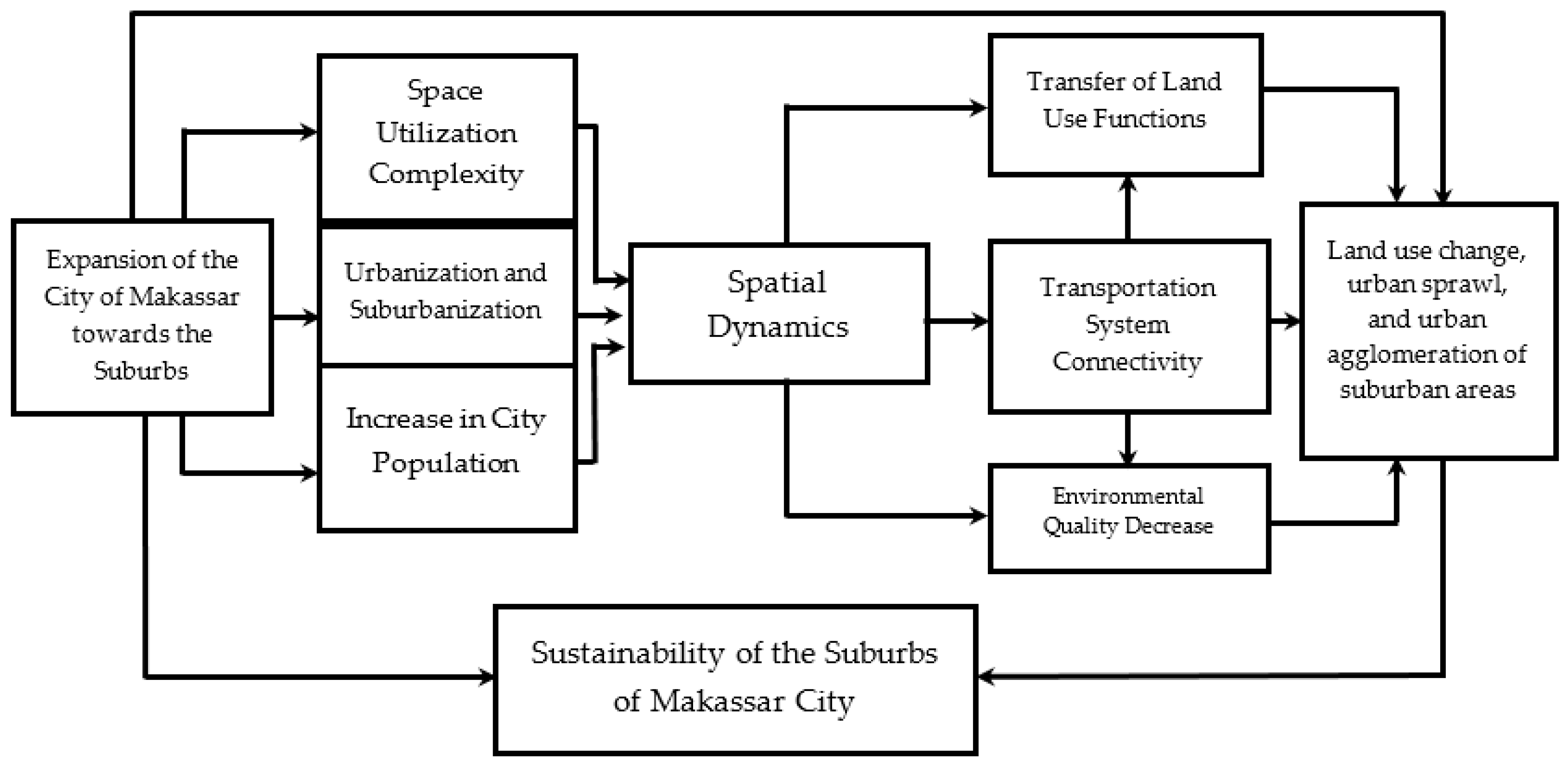
2. Conceptual Framework

The increase in development activities in the suburban area is indicated by the conversion of productive agricultural land to residential development and socio-economic activities. Knox et al. [50] formulates urbanization as a process of spatial and economic change caused by human factors and their impact on natural resources which results in economic, social, and physical conditions as well as problems that must be faced in the formulation of urban development policies. The faster the rate of economic growth, the faster the trend of population urbanization and its impact on the prevalence of poverty and urban inequality [51]. Thus, urbanization as a process of forming cities and communities will have an impact on inequality and socio-economic disparities. Increased urban activity and transportation have a direct impact on ecosystem conditions [52]. Urban spatial dynamics contribute directly to changes in land-use patterns, urban ecology, morphology, and the sustainability of urban diversity [53].

2.1. Urban Sprawl and Urban Agglomeration

The expansion of the area due to urbanization has an impact on the conversion of land-use functions and the suburbanization of the suburban areas in relation to the development of new areas for various urban activities. Furthermore, land-use conversion cannot be separated from the city development policy set by the government due to the demands of development needs. Furthermore, urban expansion towards suburban areas contributes to economic growth, and population growth as well as the impact on environmental quality degradation [54]. That is, urban expansion is closely related to the preparation of development zones and new economic activities in suburban areas [55,56].
That is, the characteristics of land-use change due to urban spatial expansion are very different for each urban area and are highly dependent on spatial physical conditions and land availability [57]. These eight factors lead to changes in spatial structure and spatial patterns in the direction of changes in population mobility and spatial use in the suburban areas which are not assessed on the basis, of agricultural land productivity but are assessed based on the function of developing space [58]. Thus, spatial expansion towards suburban areas contributes to changes in spatial structure, spatial patterns, and urban agglomeration [29]. The distribution flow of goods and services, labor migration, and increased economic productivity cause social mobility vertically and horizontally [59].

2.2. Transportation System Connectivity

The connectivity of the core city transportation system to the hinterland area is a triggering factor for urban sprawl and urban agglomeration. Urban sprawl has a significantly negative impact on environmental efficiency, but with the continual improvement of industrial agglomeration, the negative effects of urban sprawl will be partially offset [60]. The increase in traffic volume on the main city roads has an impact on congestion and the traveling time to the destination area becomes inefficient and travel costs become quite high [61]. The economic cost and environmental impact of traffic jams in large metropolitan areas are enormous [62]. Transportation system connectivity due to spatial expansion is closely related to urban sprawl and urban agglomeration that develops in suburban areas. Over-agglomeration in a region, mainly triggered by poor planning and mismanagement of resource allocation, may also become a barrier for sustainable development [63].

2.3. Sustainable Development of the Suburbs

The expansion of the core city area to the suburbs has an impact on the integration of the urban system and its effects on the socio-economic conditions of the community. As a result, the people who originally occupied the land often lose their land as the main source of livelihood for the community [64]. In developing countries, in particular, cities have experienced rapid growth in transport-related challenges, including pollution, congestion, accidents, public transport decline, environmental degradation, climate change, energy depletion, visual intrusion, and lack of accessibility for the urban poor [65]. Urban sustainability has become a significant challenge globally due to rapidly growing urbanization and industrialization [66]. Sustainability is often conceived of as an attempt to balance competing economic, environmental, and social priorities [67]. Furthermore, by integrating functions, various ecological and socio-economic services can be provided simultaneously and synergies can be developed that enable greater overall performance and more sustainable development [68]. The conceptual framework of this study is presented in Figure 1 below.

3. Material and Method

3.1. Research Design
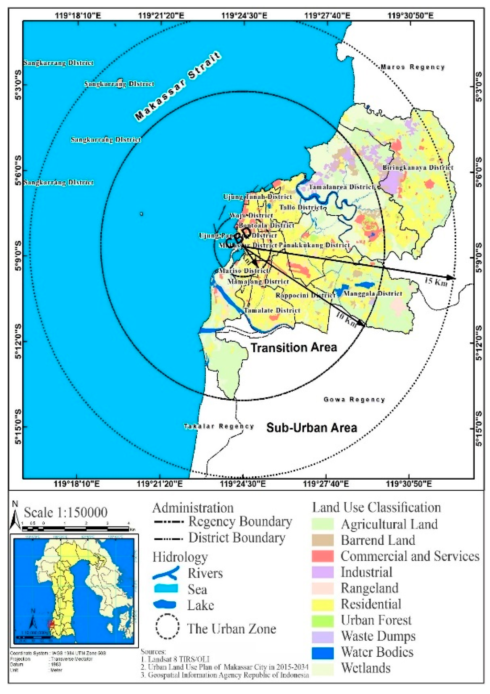
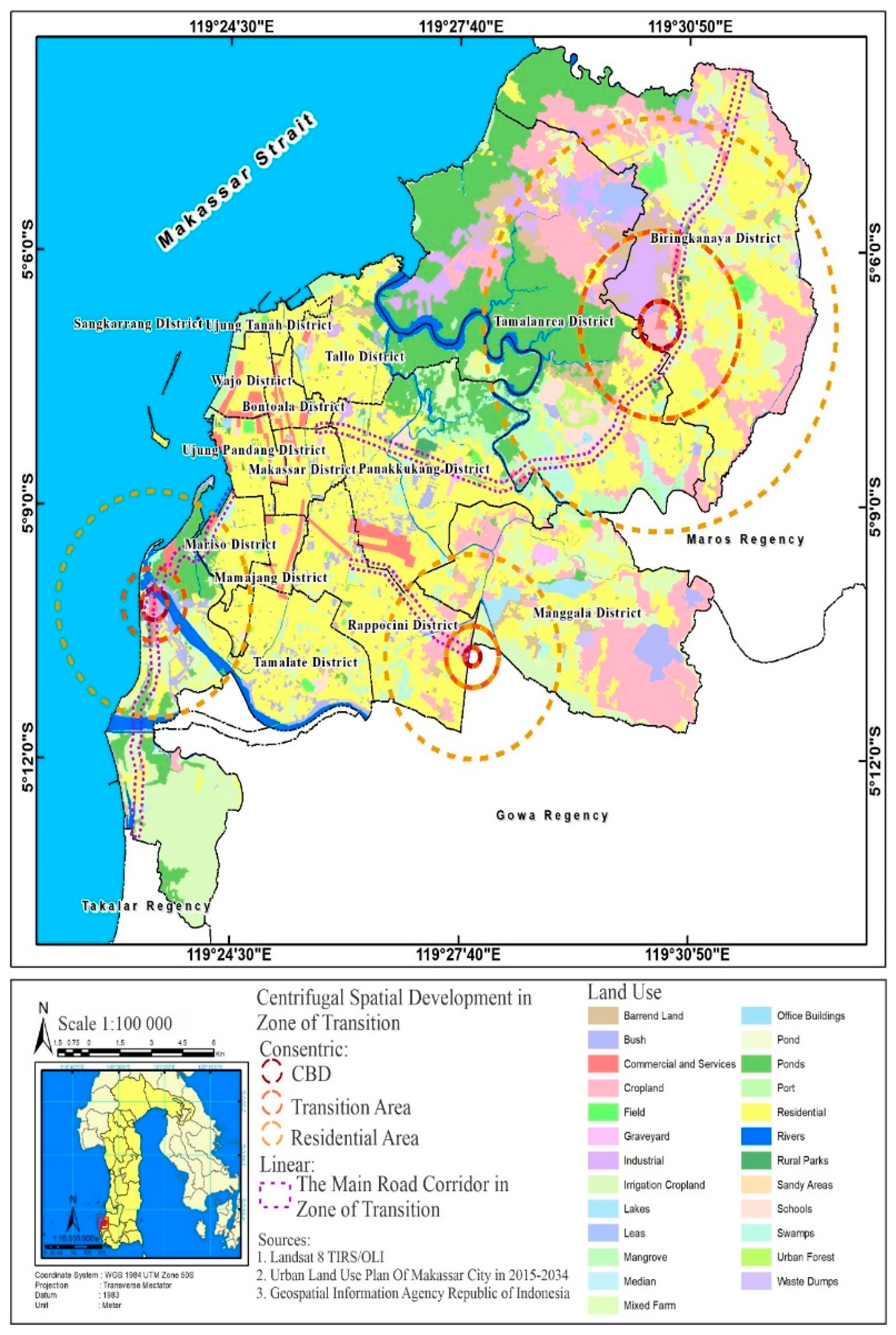
This study is directed at understanding that urban sprawl, land-use change, and urban agglomeration and their impact on environmental quality degradation in suburban areas. This study uses a combination of quantitative-qualitative approaches sequentially. The case studies were selected in this study with the following considerations: First, the complexity of spatial use and environmental degradation are quite prominent problems in the dynamics of suburban development. Second, the urban sprawl case has an impact on the sustainability of the urban system of Makassar City. Third, the context of the case of land-use change on the outskirts of Makassar City is quite complex. These three things are very strategic problems in the growth and development of big and metropolitan cities. This means that the spatial expansion of primary cities in the metropolitan urban system contributes to changes in land-use, urban sprawl, and urban agglomeration towards urban spatial integration and affects the sustainability of the city. In accordance with the chosen approach, namely case studies, this type of research is a combination of quantitative-qualitative approaches [69].

3.2. Study Area

Makassar City is the core city in the Mamminasata Metropolitan urban system. This determination is based on the following considerations: (1) the gateway to the development of Eastern Indonesia, in relation to the distribution of goods and services, as well as transportation service nodes; (2) the development of Makassar City has a direct impact on environmental conditions, the transportation system and the socio-economic conditions of the community; (3) Urban expansion contributes to changes in land-use. Spatial distribution plays an important role as an instrument for controlling the use of urban space [70]. The current population of Makassar City is 1,526,677 people with an average growth of 2.9% per year [71]. This figure is higher than the national population growth average of 1.4%. Urban sprawl, land-use change, and urban agglomeration are formed due to the support of the main road corridors and the connectivity of the Metropolitan Maminasata urban transportation network system. The road corridors include (1) Perintis Kemerdekaan Corridor with a road length of 11.93 km; (2) Hertasning Corridor with a road length of 3.76 km, and (3) Metro Tanjung Bunga Corridor with a road length of 4.7 km. In addition, urban sprawl is also triggered by the existence of commercial activity centers and large-scale residential areas that are predominantly developing in the suburban area. The geographic location of the Makassar City area based on the district and the population of Makassar City is presented in Table 1 below.
Table 1 the area of Makassar City which consists of 15 districts and 127 villages. Furthermore, the development of Makassar City shows that the distribution of the population tends to be uneven and is predominantly concentrated in the suburban areas, namely (i) Biringkanaya District with as many as 220,456 people, (ii) 149,664 people in Panakkukang District, and 149,487 people, and in Manggala District as many as 149,487, (iii) Rappocini District 170,121 people, Panakkukang District 149,664 people, and Tallo District 140,330 people. The district area is categorized as a transition zone and a zone for the suburban area of Makassar City. The study locations are presented in Figure 2 below.

3.3. Method of Collecting Data

In this study, the development of suburban areas is associated with changes in land-use, urban sprawl, and urban agglomeration. The data in this study uses a nominal scale to classify objects, individuals, or groups for categorization needs. Measurements using a nominal scale are carried out by giving numbers to the object under study. Furthermore, the data in this study are measured using indicators: (1) data on land-use change is measured by indicators, namely spatial use patterns, spatial functions, and the area of built-up areas. (2) Urban sprawl data is measured by indicators, namely population density and building density. (3) Data on urban activities is measured using indicators, namely the distance to the center of the activity, the type of activity, and the characteristics of the activity. (4) The transportation system is measured by indicators of population mobility, road network, and road functions. (5) The decrease in environmental quality is measured by indicators, namely the source of pollution, the type of activity, and the carrying capacity of the environment. Thus, the data collection methods in this study were obtained through observation, surveys, and documentation data. The development pattern of urban activities in suburban areas is assessed based on the grouping of activities, namely (i) housing and settlement, (ii) trade and services, (iii) industry, and (iv) educational activities. These four activities are urban primary functions that develop in the suburbs of Makassar City and are a determining factor for urban agglomeration towards the spatial integration of the Mamminasata Metropolitan urban area. Agglomeration is related to the spatial concentration of population activity and economic activity [72]. Furthermore, agglomeration is a form of positive externality in production which is one of the factors causing its urban growth [73]. The stages of data collection and data analysis in the study are presented in Figure 3 below.
Data grouping in this study was carried out by comparing the results of field observations, surveys, documentation, and mapping results from satellite imagery maps. Thus, the data in this study were divided into two main categories, namely primary and secondary data. Land-use change data is reviewed based on the dynamics of the development of Makassar City for the period 2006–2020 which is adjusted to the results of observations made in the field. Land use data is then carried out by overlapping maps and processed through a geographic information system (GIS). Furthermore, the urban sprawl in this study was assessed based on indicators of population density, building density, accessibility, road network, distance to the city center, and mixed land-use, namely housing, workplaces, and socio-economic facilities [74,75]. Each studied variable is then assigned its average value and standard deviation to determine the size of the sprawl and its impact. The measurement of urban agglomeration in this study is grouped into three categories, namely (i) agglomeration in the city center, (ii) agglomeration in the transition zone, and (iii) agglomeration in the suburban zone. Urban agglomeration has an impact on increasing the movement of rural populations towards urban areas [76,77].
Data collection in this study was carried out through observation, surveys, and documentation. Researchers play a role as the main instrument in collecting data or information through observation and documentation [78,79]. Furthermore, the main survey instrument is a questionnaire obtained from respondents. Thus, the two instruments in this study are triangulating. This means that the data in this study were obtained through observation, questionnaires, and documentation. Data collection methods and data sources in this study are presented in Table 2 below.

3.3.1. Observation

The observations in this study were used to observe the characteristics of the urban sprawl, changes in land-use, urban agglomeration, and mobility of the population in the suburbs of Makassar City. The instruments used in the observation were base maps and field notes. Observations were used to trace the data: (1) urban sprawl that developed in the suburban area; (2) changes in land-use based on development activities carried out by the community and developers during a certain period of time; (3) the grouping of urban activities, namely housing and settlements, trade and services, industry, offices, and education, (4) the system of socio-economic activities that develop in the suburban areas; (5) mobility of the population from the suburban area to the center, and (6) urban activities that develop and their impact on the decline in the quality of suburban areas. Furthermore, observations in this study are also used in data retrieval, including (a) the pattern of housing development activities carried out by the community and developers; (b) transportation facilities used by the community in mobility, and (c) new development areas developed by the government. The data obtained through observation is used by researchers to describe changes in land-use and developing urban agglomerations. The aim is to describe the urban sprawl and land-use changes that are developing on the outskirts of Makassar City.

3.3.2. Questionnaire

The use of questionnaires in this study is used for two functions: (1) description, which describes the socio-economic characteristics of communities located in rural areas; and (2) measurement, namely the assignment of values to each variable and indicator used. The questionnaire in this study used a structured and unstructured list of questions that had been prepared previously. Furthermore, the questionnaire was used in tracing the data: (1) development patterns carried out by the community and developers; (2) changes in land-use in suburban areas; (4) urban activity grouping; (4) the system of urban activities in relation to the socio-economic activities of the community; (4) the transportation system (origin and destination patterns) based on population mobility, distance to the city center, and the means of transportation used, and (5) decreasing environmental quality based on developments carried out by the community and developers. The results of data collection through questionnaires are then measured using interval and ratio scales. The questionnaire was distributed to districts that are included in the category of suburbs in Makassar City. The reason the researchers determined the location was to compare sprawl, land-use change, urban agglomeration, transportation system, population mobility, and urban activities that affect environmental degradation.
Data collection through questionnaires was carried out from August to October 2020. Furthermore, structured interviews using a questionnaire conducted by researchers were carried out by asking questions to respondents based on predetermined questions. Filling in the questionnaire was not submitted to the respondent but was guided by researchers and enumerators. The enumerators were chosen based on considerations, namely, those who can collect data, are close to and understand the socio-cultural conditions of the respondents. Before carrying out their duties in the field, the enumerators were given instructions and exercises in filling out the questionnaire as well as techniques for conducting interviews with respondents. The criteria for actors who fill out the questionnaire (respondents) are (i) local residents located in suburban areas, and immigrants who build a shelter in suburban areas, (ii) people who have socio-economic activities in suburban areas, (iii) developers who carry out housing development activities in suburban areas, and (iv) local government. Furthermore, the respondents in this study were determined using a purposive sampling technique which the researcher determined based on certain characteristics. Withdrawal of samples refers to Isaac and Michael [80]. Furthermore, the formulations used in determining the sample are as follows.
s = λ 2 NPQ / d 2   ( N - 1 ) + λ 2   PQ
where s is the number of samples, N is the number, of population λ2 is Chi-Square, the error rate is 1%, 5%, and 10% d = 0.05 P = Q = 0.5. The number of samples in this study was set at 400 samples. The number of samples (respondents) in this study is presented in Table 3 below.

3.3.3. Documentation

This study uses various documents relating to the situation and conditions of the suburbs of Makassar City. The documents referred to include (1) Makassar City Spatial Plan obtained through the Makassar City Spatial Planning Service; (2) Population data obtained from the Makassar City Statistics Office; (3) the socio-economic profile of the community is obtained from the District Office, and (4) Plans for development and development of the outskirts of Makassar City are obtained through the Regional Development Planning Agency and developers who are carrying out development. The four documents are used by researchers to support the data from observations and questionnaires.

3.4. Data Analysis Method
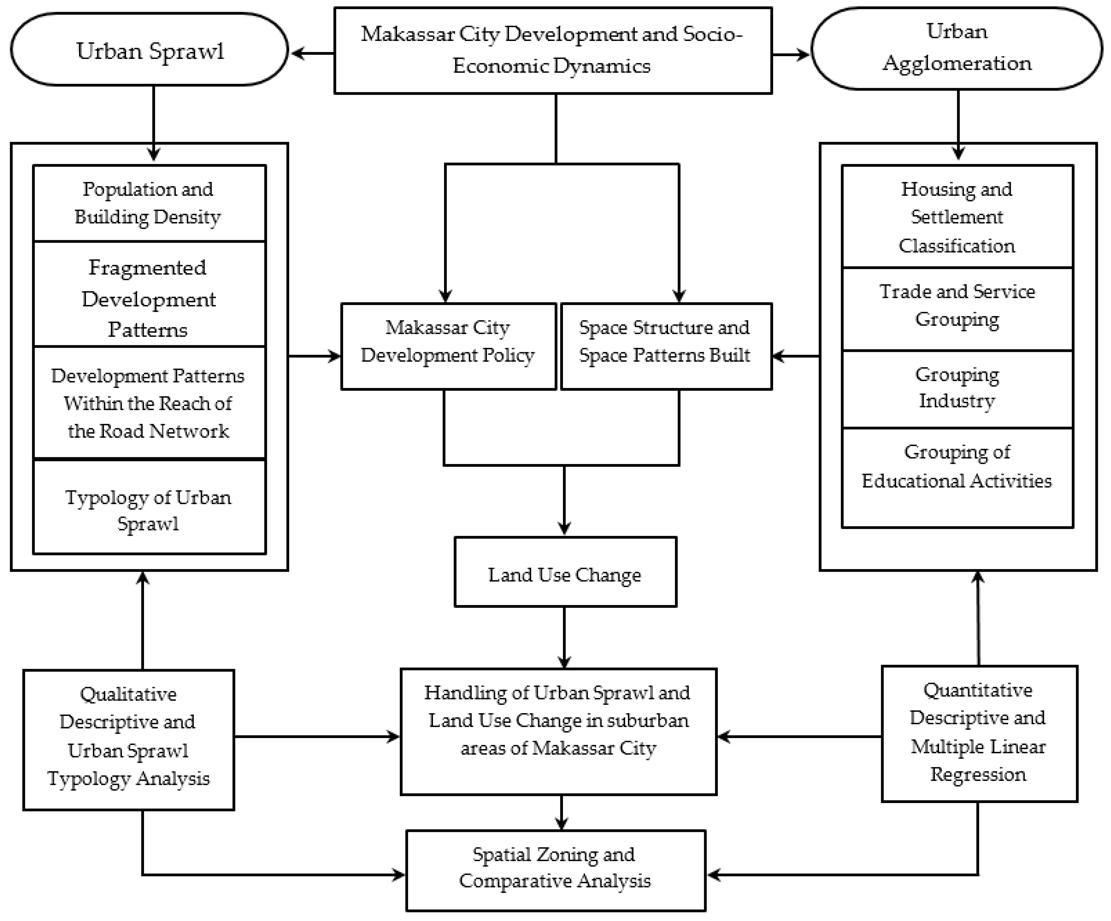
Qualitative data analysis was carried out during data collection and after completing data collection. The analysis is carried out interactively and continues to completion. Thus, qualitative data analysis in this study is divided into three categories, namely data reduction, data display, and conclusion. Data reduction is carried out with the following considerations: (1) the data obtained in the field is quite a lot, complex and complicated, so that data reduction and data grouping must be done immediately for interpretation needs; (2) selecting and summarizing the main things, focusing on the important things, themes and patterns, then formulating the conclusions; (3) reduced data are used to provide a clear picture according to the focus of the study; (4) data reduction is done by providing codes on certain aspects according to the objectives to be achieved in this study.
The quantitative analysis in this study is used to answer research questions, how are the effects of urban sprawl, land-use change, urban agglomeration, urban activity systems, and the transportation system on environmental degradation in the suburban area. Multiple regression analysis in this study is used to determine how much influence the independent variable has on the dependent variable and to predict the value of the dependent variable when all the independent variables have known values. The urban sprawl analysis considers the ratio of households in one village to total households to one sub-district area (A), the ratio of the built-up area of the district to the total built-up area (B). Furthermore, the relationship between the two ratios in the sense that, if (A) is reduced (B) results in a value of 0 then it is categorized in normal conditions, if the result is positive, it indicates compact, and if the value is negative, it indicates a sprawl [81].
Sprawl measurement for each district in Makassar City uses several analytical approaches, including (1) population density analysis; (2) building density analysis; (3) the analysis of the distance to the city center uses a network analysis approach, the indicators being assessed are the road network and the distribution of buildings; (4) development analysis, in relation to road network coverage and distribution of new buildings in the 2020 period, using a buffering approach with a distance of 100m, as the basis for assessing the highway strip index; (5) analysis of the construction of irregular activity patterns, using a distance approach of the location of new housing buildings that are fragmented and located outside the center of the old residential building to the center of activity. The distance calculation uses the road network analysis approach and the results obtained are described using the development index approach without a pattern; (6) sprawl characteristics are classified into three levels and using scoring analysis. The results were then mapped for each category, namely high, medium, and low; (7) urban sprawl level analysis uses scoring analysis, namely (i) score 1 shows the influence of the variable on the sprawling level with the low category, (ii) score 2 shows the variable on the sprawling level with the medium category, and (iii) score 3 shows the effect of the variable on the sprawl in the high category. The results of the assessment through scoring are then followed up for sprawl classification. The aim is to define three typology categories based on the class range results. The formulations used in determining the urban sprawl typology category are as follows:
KP   = P / LT KB   = UB LT IHS   = JBUBJJ / JBU
IHS   =   TBU / JBU RK   =   NT NTR / K
Explanations related to the formula used include (1) Population Density (KP) is calculated based on the ratio of the total population (people) to the area of districts and districts (hectares); (2) building density (KB) is calculated based on the ratio of the number of buildings (units) to the area of built land (hectares); (3) the highway lane index (IHS) is calculated based on the ratio of the number of new buildings in road network support (units) to the number of new buildings (units) for the period 2006, 2010, 2015 and 2020; (4) the highway lane index (IHS) is calculated based on the ratio of the total building distance (meters) to the number of new buildings (units) for the period 2006, 2010, 2015 and 2020, and (5) class distance (RK) is calculated based on the highest score minus the lowest score for the number of classes (3). The results of the analysis are then explained descriptively qualitatively and quantitatively. To test the effect of urban sprawl (X1), land-use change (X2), urban agglomeration (X3), urban activity system (X4), transportation system (X5), environmental quality degradation (Y), based on questionnaire data obtained in the field. The data is then analyzed using multiple regression methods. The analytical formulations used are as follows.
Y = b 0 + bX 1 + bX 2 + bX 3 + b n x n + ε
r xy = n X i y i X i y i n X 2 i ( X 2 i ) 2   n y 2 i ( y i ) 2
y . 12   = R 2 y . 12
R 2 y . 12   = 1     JKG / ( n 1 )   s 2 y
where Y is the dependent variable, b0 is the regression constant, b1, b2 the regression coefficient/influence X1, X2, X3 are the independent variables, ε = 0. The correlation coefficient (r) is a measure of the linear relationship of the X and Y variables. The r-value ranges from (+1) to (−1). The value of r that is (+) is indicated by the value of b that is (+), and the value of r that is (−) is indicated by the value of b that is (−). If the value of r approaches +1 or r approaches −1, then X and Y have a high linear correlation. If r = +1 or r = −1, then X and Y have a perfect linear correlation. If r = 0, then X and Y do not have a linear relationship. R2y.12 is the coefficient of determination for multiple linear regression, JKG is the sum of squares of errors, and s2y is the sum of squares of y (corrected).

4. Result

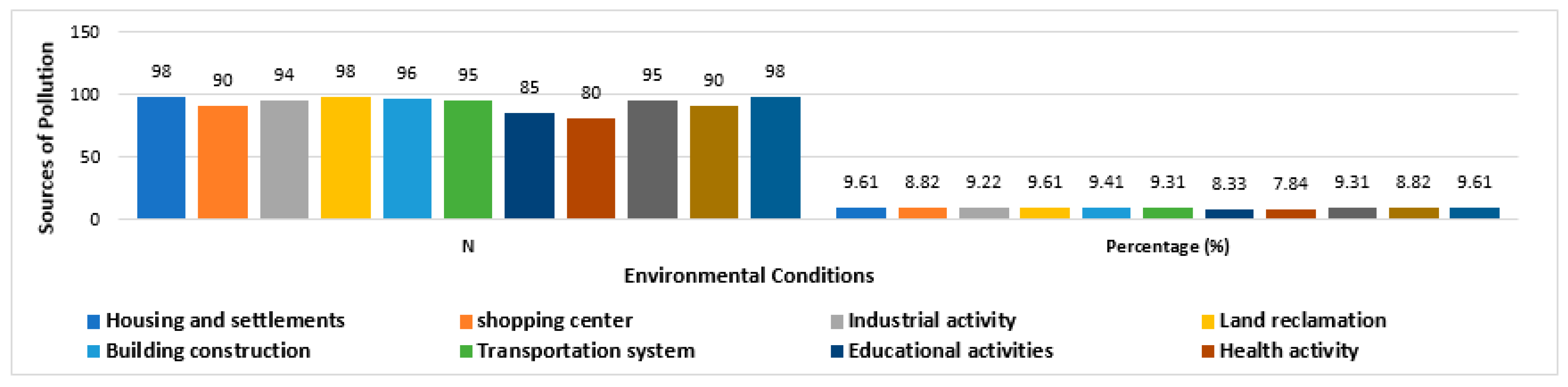
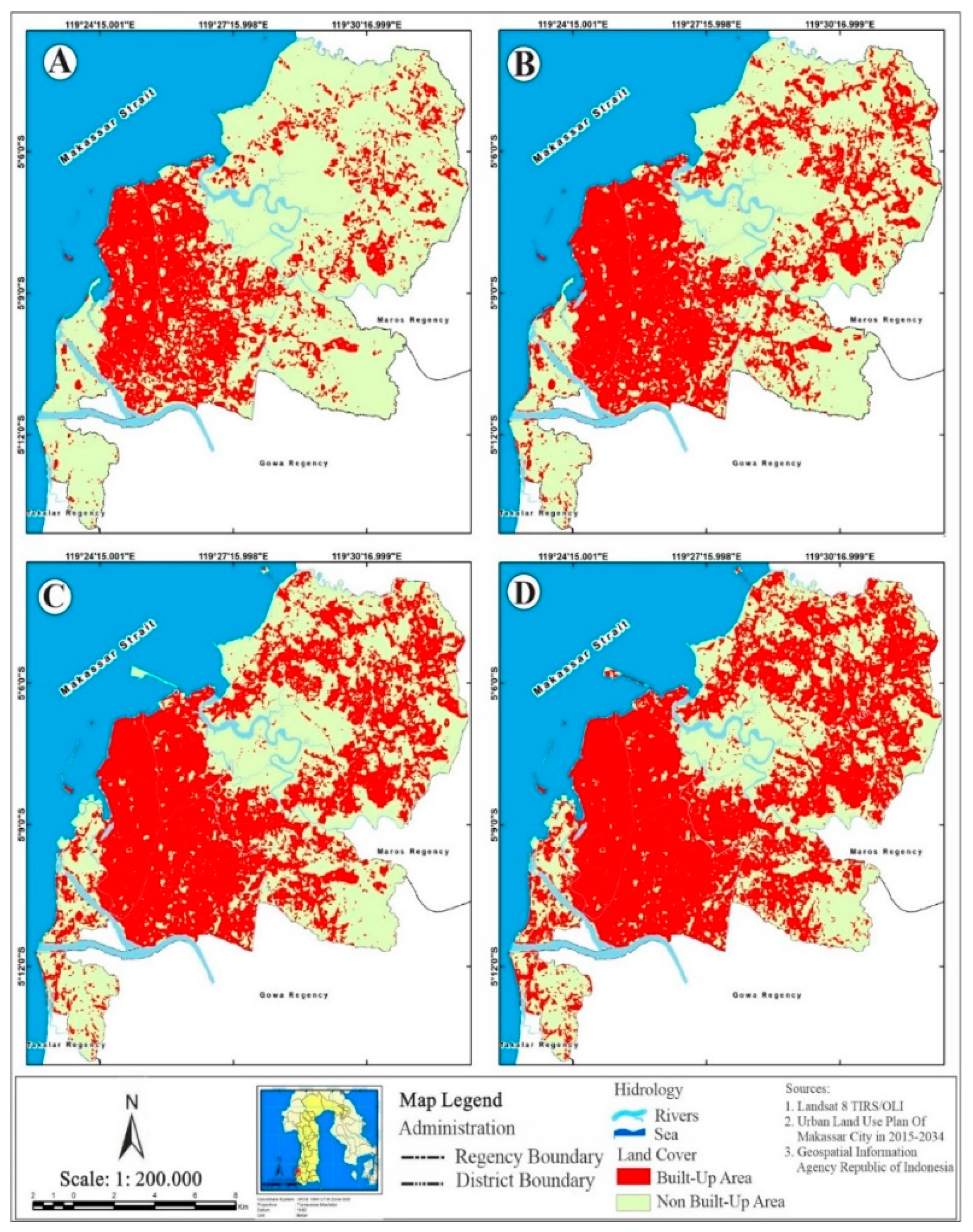
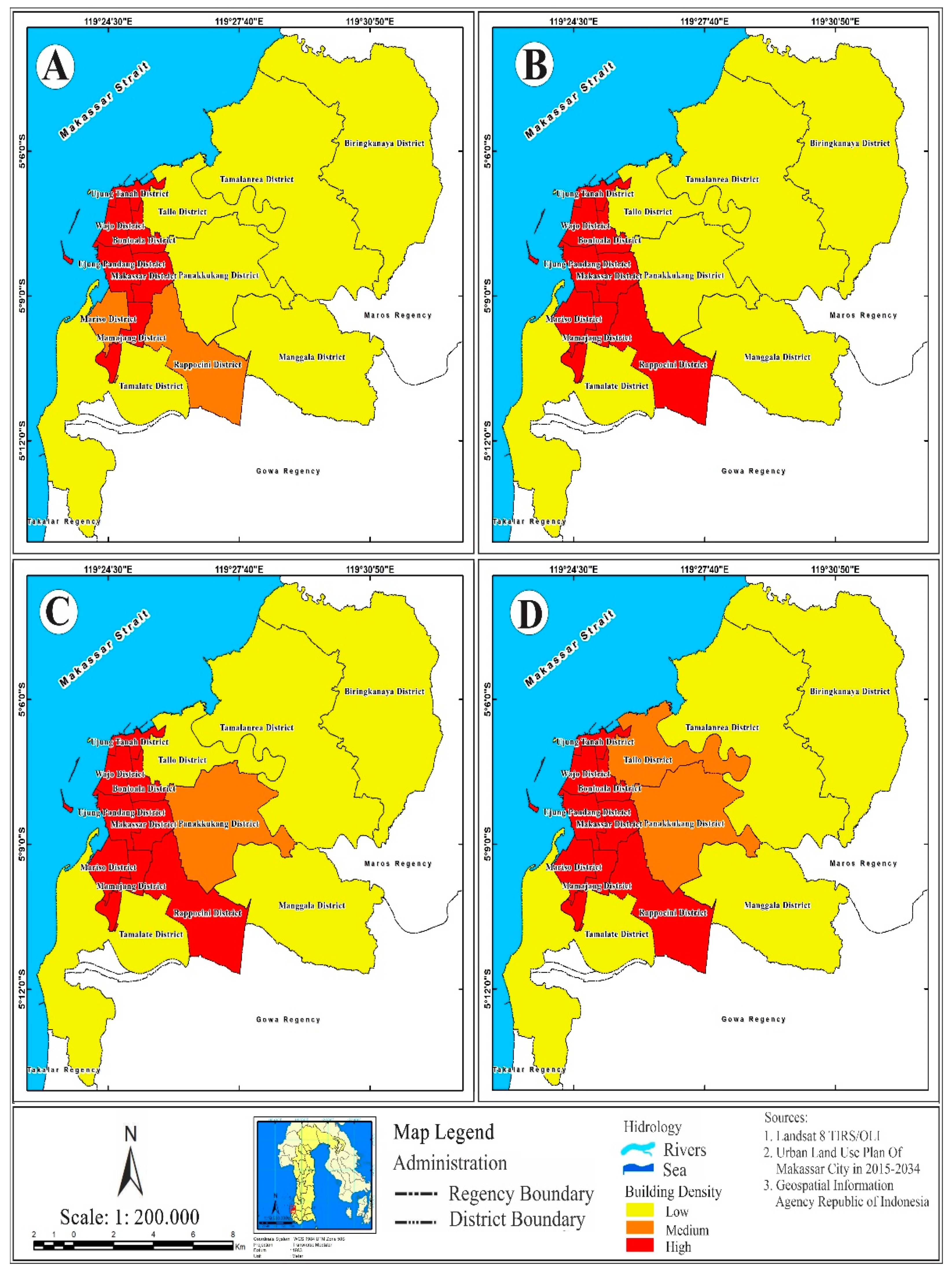
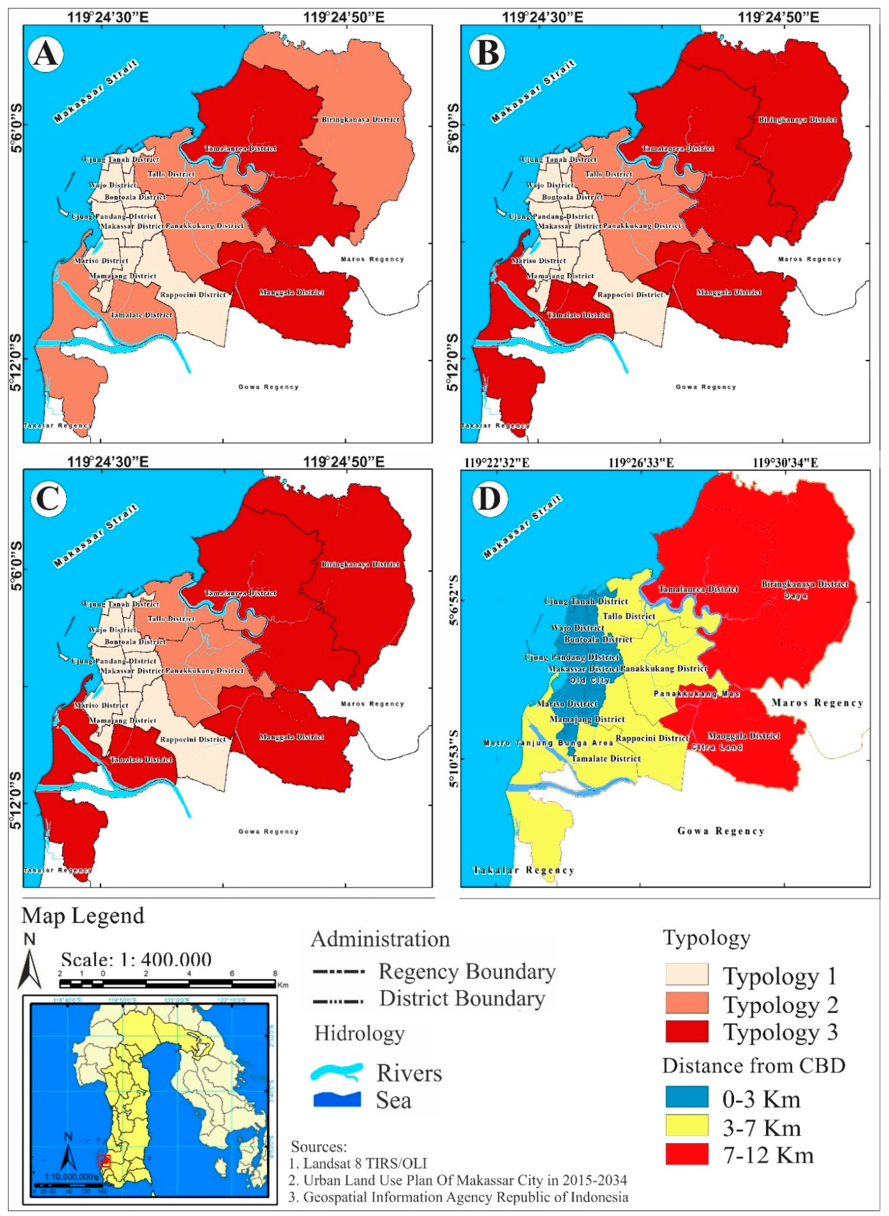
4.1. Determinant of Urban Sprawl and Land Use Change

The expansion of the Makassar City area to the suburbs has an impact on changing the characteristics of transportation towards increasing population mobility. The change in transportation characteristics is due to the increasing need for transportation services for the community in relation to the existence of developing centers of socio-economic activities. Furthermore, the economic activity pattern of urban center residents and suburban residents together form a travel profile that is influenced by external and internal factors. External factors relate to the movement of transportation from the city center and the movement of transportation to the urban area of the Mamminasata Metropolitan Area. Meanwhile, internal factors are influenced by the existence of new housing complexes and the mobility of the population towards the center of socio-economic activities and the movement towards the city center. The transportation system and population mobility in suburban areas are closely related to the dynamics of the development of Makassar City. The spatial development of Makassar City is linear and concentric is presented in Figure 4 below.
Figure 4 shows a linear and concentric spatial development pattern in the suburbs of Makassar City. This condition specifically occurs in the center of the suburbs as a result, of the accumulation of socio-economic activities, and the center point is marked by the existence of a shopping center, followed by the development of various other socio-economic activities, and supported by the existence of new settlements that are cohesive. Field facts found to illustrate that efforts to control the spatial physical form of Makassar City in the transition zone and the suburban zone are much easier, with the consideration that outside the built-up area it is still empty land, so that regulations that lead to the acceleration of the city’s spatial physical development can be implemented with minimal resistance. Field findings show that new development areas in Makassar City have the potential to experience floods, land erosion in river basins, and coastal abrasion. The triggering factors are land reclamation, land-use for river use areas, and damage to mangrove forest habitat. Land use planning is an action to eliminate disaster risk and improve environmental quality for the better [82]. The change in spatial use of Makassar City is presented in Table 4 below.
Table 4 shows the change in the use of space in Makassar City towards urban differentiation due to the increasing scale of the modern industrial society and the development of new growth poles. Three things that underlie this process occur, among others: (1) the distribution of the range and intensity of the relationship between activities towards the changing character of modern society; (2) differentiation of spatial functions and community activity patterns, and (3) the more complex spatial organization. Field facts found show that spatial physical changes in Makassar City have a positive contribution to socio-economic changes at the micro-level of society. Furthermore, if it is based on the process of forming spatial and social diversity in relation to the developing socio-economic characteristics, three symptoms are found, namely: (1) changes in the intensity of economic activity towards the creation of a new economic order, which requires certain types of expertise and skills to access work of a formal nature. This condition illustrates that educational background as an index of social differentiation is an important factor; (2) differentiation of new functions which tends to continue due to increased reach and services and their impact on social and economic choices for the community. This condition allows for a number, of alternative activity patterns for the community; (3) social order moves towards changes in population mobility and population composition towards societal differentiation. The differences and assimilation of the community, both migrants and indigenous people, are moving towards social and cultural transformation as one social group [83].
Field facts found to illustrate that the intensity of land-use change is influenced by several factors, including (1) ease of licensing issued by the government and its impact on land buying and selling. This condition is marked by a change in the status of community land ownership to developer ownership. Furthermore, changes in land ownership status are followed by the construction of large-scale housing and settlements equipped with supporting facilities and infrastructure, which are predominantly inhabited by immigrants; (2) land reclamation, this condition is characterized by development carried out by the developer and the intensity of land cover changes in water catchment areas, river benefit areas and coastal areas; (3) increasing urban activity development activities and new housing developments have an impact on decreasing the environmental quality of the suburban areas. The degradation of the environmental quality in the suburbs of Makassar is presented in Figure 5 below.
Figure 5 shows the decline in the environmental quality of Makassar City based on developing urban activities. Three interpretations that can be proposed for these conditions, namely: (1) housing and settlement development, land reclamation, and land-use change contributed positively to environmental degradation with each value of 9.61%; (2) building construction with a value of 9.41%, household waste and transportation systems with a value of 9.31% against environmental degradation; (3) shopping centers and domestic waste contributed positively to environmental degradation with a value of 8.82%; and (4) educational activities with a value of 8.33%, and health activities with a value of 7.84% against a decrease in environmental quality. Urban expansion results in socio-economic transformations with relevant implications for land in suburban areas, leading to environmental concerns about land degradation and increased desertification risk in ecologically fragile districts [84]. This condition is characterized by the grouping of people based on economic capacity, segregation, and gentrification in suburban areas. The comparison of urban sprawl in Makassar City is presented in Figure 6 below.
Figure 6 shows the urban sprawl in the dynamics of the development of Makassar City. Interpretations that can be proposed regarding urban sprawl include (1) to the east, marked by changes in land-use towards land-use for housing and settlements, industry, and shopping centers; (2) to the north, marked by conversion of productive agricultural land covering an area of 5880.68 hectares; (3) to the south, it is marked by coastal reclamation for the development of economic activities covering an area of 159.24 hectares. The developing urban sprawl has an impact on changes in land cover, typology, and morphology, increased population mobility, population density, and traffic congestion on the main city road corridors. Changes in the spatial pattern of Makassar City due to the sprawl and its associated impacts are marked by the uneven distribution of facilities and the distribution of settlements in the urban area. This condition has an impact on the accumulation of various activities in certain areas, scarcity of infrastructure, and disparity of socio-economic services in the suburban areas. The facts on the ground that were found show that the existence of new settlements built by developers has a positive contribution to the differentiation of jobs and people’s lifestyles.
The factors that trigger sprawl in the suburbs of Makassar City includes (1) lower land prices and high land purchase transactions, which developers use to build large-scale settlements and commercial areas; (2) Support for infrastructure development developed by the government, namely road infrastructure, airports and other infrastructure; (3) increasing community income, marked by the ability of the community to pay land tax and mobility for work, business, and social activities; (4) consistency in the implementation of the Makassar City planning plan, in relation to controlling spatial use; (5) the tax rate is quite low when compared to the tax rate at the city center; (6) high population growth due to urbanization and migration; (7) residential options for high-income groups to build a shelter in suburban areas. These seven factors make a positive contribution to the suburbanization of the suburban areas towards increasing population density. Increased industrial activity in line with housing development not only has an impact on increasing population but also contributes to the deterioration of the environmental quality of suburban areas [14].
The ever-increasing population in the suburban area is positively associated with a reduction in agricultural land and an increase in building density. This condition illustrates that the expansion of the spatial layout of Makassar City to the outskirts of the city has an impact on changing the livelihoods of local communities from being agrarian to industrial cities. Furthermore, the orientation of local community activities is dominant due to changes in environmental conditions, namely laborers, masons, and construction workers, including urban informal activities (mobile traders and food stalls) and a small proportion of them still work in agricultural activities but are not dominant. Metropolization is the cause of the economic transformation, spatial use, and social culture of society [85].
The population density of Makassar City (see Figure A1 in Appendix A). The results of the population density analysis show that: (1) The high-density category is located in the Tallo District, Bontoala District, Makassar District, Mariso, and Mamajang District with population density figures of 24,070–33,935 people/hectare; (2) The category of medium density is located in Wajo District and Rappocini District with a number of 15,806–18,431 people/hectare; (3) The low-density category is located in the Ujung Pandang District, Tamalate District, Panakkukang District, Tamalanrea District, Manggala District, Biringkanaya District, and Sangkarrang Islands with a figure of 3638–11,047 people/hectare. Interpretations that can be proposed are related to the population density of Makassar City, namely: (a) district areas with high-density categories show a fairly, low urban sprawl; (b) districts with a low population density category show a high level of urban sprawl. These results confirm that urban sprawl tends to develop in districts with low density in relation to the available land area. Thus, land area and low land value are factors that trigger the community and developers for new housing facilities and develop towards large-scale settlements in the suburban areas. The role of government is very important to maintain environmental balance and ensure the rights of future generations to the natural environment [86].
The results of the field confirmation show that the role of the government also contributes to the sprawl in the suburban areas. This condition is marked by the number of building permits issued and location permits granted to developers. Thus, the urban sprawl trend in the suburbs of Makassar City is influenced by three main factors, namely (i) the use of vacant land for the construction of housing facilities by the community, (ii) the construction of new housing by developers, and (iii) government policies in granting location permits. and building permits. Field facts found indicate that the development mechanisms and procedures in the suburbs of Makassar City have not yet referred to the predetermined spatial plan. The development of large-scale settlements affects the typology and morphology of the suburban area towards the formation of the built environment [87].
The density of buildings in Makassar City (see Figure A2). Interpretations that can be proposed for these results: (1) in 2005 the building density level was 30.47%, then in 2019, the building density was 60.24%. This figure shows that for 15 years the building density in Makassar City has increased by 29.77%. (2) Building density is differentiated based on four main classifications, namely (i) building density at the city center of 91.22%, (ii) the eastern area of Makassar City covering five sub-districts with a building density of 63%, (iii) the area the North covers four districts with a building density of 76.91%, (iv) the South includes three districts with a building density of 80.3%. In addition, the relatively low building density indicates irregular development. Field facts that have been found illustrate that the massive increase in building density is located, in the East and South regions. Furthermore, the districts detected with a fairly, low level of building density are located, in the Tamalanrea District, Tamalate District, Manggala District, and Biringkanaya District. The four districts are categorized as experiencing irregular developments in the dynamics of the development of Makassar City for the period 2006–2020. The spatial expansion of Makassar City to the suburbs area has a positive correlation with changes in the lives of local communities. This condition is marked, social relations between communities are starting to decline and only take place in small groups. Field facts that were found indicate the existence of local community settlements that tend to be clustered in certain locations and come into, contact with new housing locations inhabited by migrant residents. Thus, urban sprawl has a positive contribution to changes in typology and morphology of the suburban area [88].
Furthermore, based on the factor of consideration, the distance to the Central Business District (CBD) location is determined based on the accumulation of spatial functions both in the old city area and on new developments in Makassar City. These CBDs include (i) CBD of the old city, (ii) CBD of Panakkukang Mas, (iii) CBD Daya, and (iv) CBD of the Metro Tanjung Bunga area. Indications for district areas that experience sprawl through buffering are set with a radius of reach as far as 5–10 km. Field facts that are found illustrate: (1) 83.20% of the sub-districts in Makassar City are within a radius of five kilometers and (2) 16.80% of the areas are in a radius of ten kilometers. Thus, the farther a district is to the CBD location, the higher the sprawl rate and the closer the district is to the CBD location, the relatively low urban sprawl rate and highly dependent on developing residential clusters. The level of income of the community influences the decision to choose the location of residence and the shape of the city is closely related to the population distribution [89].
The typology and comparison of the distance between the districts to the CBD location (see Figure A3). Three things can be explained in relation to this, among others: (1) 25.42% of districts which are five kilometers from the old city center; (2) 39.89% of districts that have a distance, of five kilometers to the CBD location of Panakkukang Mas; (3) 37.09% of district areas that have a distance, of five kilometers to CBD Daya, and (iv) 18.58% of districts that have a distance of five kilometers to the CBD of the Metro Tanjung Bunga area. In the context of urban sprawl in Makassar City, slum settlements are found adjacent to the CBD location. The location of these slum settlements is marked by the existence of the urban poor, characterized by spatial segregation and a decline in environmental quality. Slum settlements that develop are closely related to poor health conditions, sources of pollution, sources of disease spread, and deviant behavior that affect people’s lives [90].
The expansion of the Makassar City area shows that 29.77% of the district experiences urban sprawl with typological diversity. Typology of urban sprawl is divided into three main categories, namely: (1) Typology 1 covers eight sub-districts or 15.32% of the total area of Makassar City; (2) Typology 2 covers two district areas or 13.01% of the total area of Makassar City, and (3) Typology 3 covers four districts or 71.65% of the total area of Makassar City. These results confirm that during the period of 15 years urban sprawl increased significantly and this increase occurred between the period 2010–2020. The field facts found show that urban sprawl is categorized as high in relation to several things, namely (i) the acceleration of development in Makassar City towards suburban areas are followed by development policies that provide easy licensing for developers to build new housing, (ii) conversion of productive agricultural land due to weak control over spatial use, (iii) massive land-use conversion in the suburban area, and (iv) land value which is quite low and the productivity of agricultural land tends to decline, causing high land transactions between local people and housing developers. Government policies related to land-use will require ecological and environmental conservation actions towards sustainable economic and social development [91]. Furthermore, the process of expanding the urban area towards the outskirts of Makassar City is divided into three categories, namely: (1) The concentric distribution is characterized by equal distribution of activity throughout the existing urban areas and this type is categorized as the slow spread. (2) The longitudinal spread is characterized by the urban stretch that develops along the existing road network. This means that the transportation network plays an important role in the process. (3) The spread of hopping is characterized by a separate building pattern from the main city and CBD.
Two categories of urban sprawl that have developed in the suburbs of Makassar City are: (1) in 2006 the trend of urban sprawl was still limited to the border area between the core zone and the transition zone; (2) In 2010–2020, the spatial expansion of Makassar City tends to expand towards the Mamminasata Metropolitan urban area which is developing rapidly both linearly following the main road corridors and developing concentrically (p-value 0.01 and z-zero 2.44). This condition develops apart from the result of a fairly, low land value, another supporting factor is the integration of the Mamminasa Metropolitan urban system. Furthermore, different conditions in the period 2006–2010 tended to develop concentrically with a p-value of 0.01 and a z-zero of 2.51. This condition is influenced by the preference for living in the suburbs. A summary of the urban sprawl typology of Makassar City is in Table 5 below.
Table 5 shows the differences in the urban sprawl typology of Makassar City. Interpretations that can be submitted regarding these results, namely: (1) in 2006 the sprawl tendency of Makassar City was dominant in developing transitional areas and new development areas, namely in Tamalanrea and Manggala Districts; (2) the 2010 period the tendency of sprawl to show dominantly towards the transition area and sub-urban Makassar City; and (3) In 2020 the dominant urban sprawl moved to the suburbs, namely in the areas of Panakkukang Districts, Biringkanaya Districts, and Tamalate Districts.

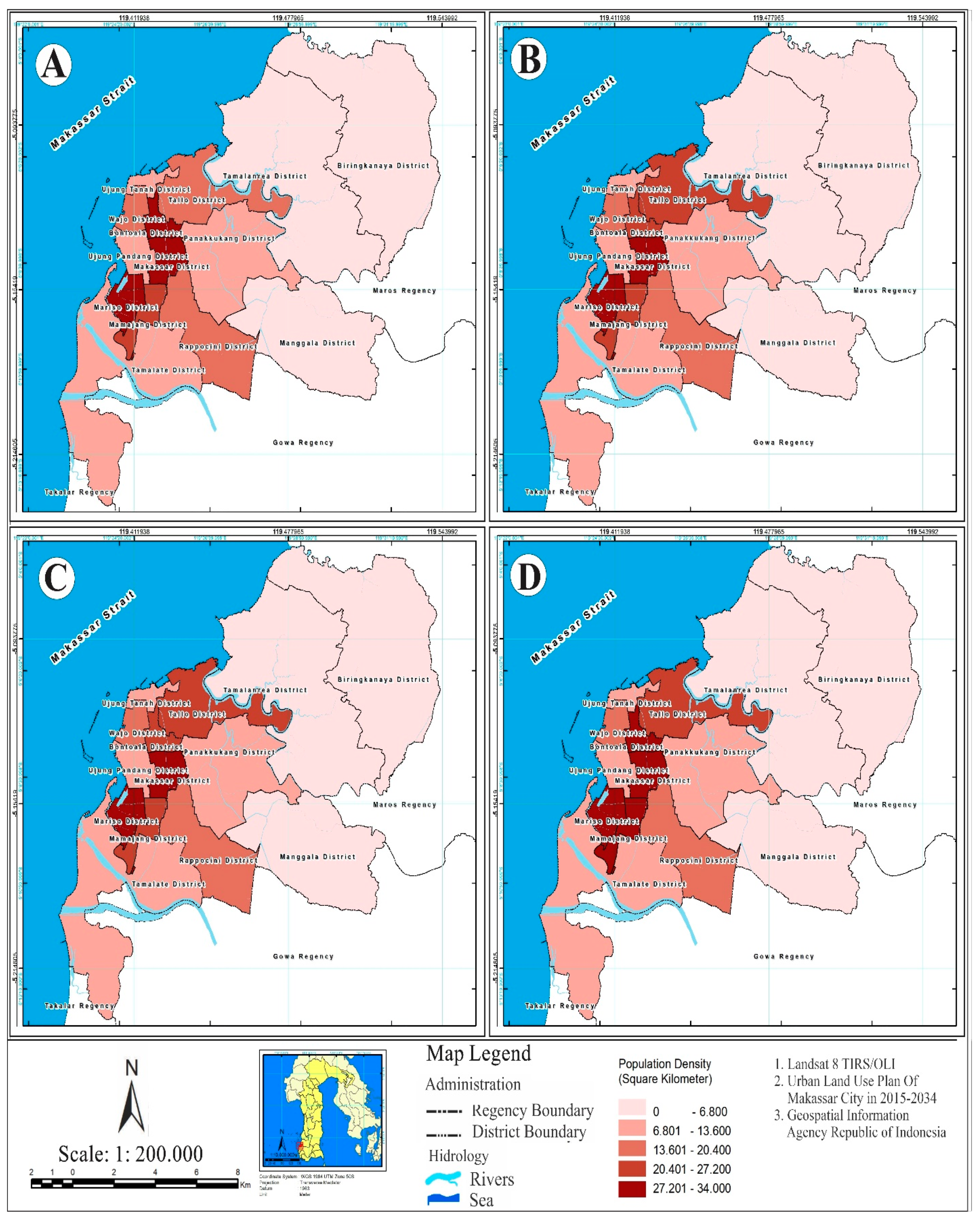
4.2. Urban Agglomeration and Transportation Systems

The position of Makassar City as a core city in the Mamminatasa Metropolitan urban system. Three factors determine urban unification, among others: (1) ease of production processes and trade flows that cause a built-in system environment; (2) Makassar City provides various socio-economic facilities as well as a variety of goods and services so that it becomes an attractive factor for the mobility of the surrounding urban population, and (3) the availability of public facilities in Makassar City, which is more dominant when compared to the surrounding cities, causes the demand for goods and services in its territorial areas to be quite high. Furthermore, the relationship between population density distribution and public service facilities has a direct relationship with the layout of public facilities [92]. Agglomeration in the development dynamics of Makassar City is characterized by the grouping of several dominant socio-economic activities that develop in the suburbs which are located directly adjacent to the Mamminasata Metropolitan urban area.
Field facts found show that along the developing road corridors are marked by the presence of shopping centers, service services, offices, industry, health facilities, and new settlements developed by the developer. The existence of the Makassar City road corridor has an impact on urban agglomeration towards the unification of the Mamminasata Metropolitan urban area. Thus, during the 2006–2020 period, the acceleration of development and economic growth of Makassar City experienced a significant increase and had an impact on labor mobility in its hinterland areas. The impact of spatial expansion on environmental degradation will require a long process in relation to the social and economic conditions of the community [93]. The comparison of urban agglomerations based on the spatial zoning of Makassar City is presented in Table 6 below.
Table 6 shows the comparison of urban agglomerations based on the spatial zoning of Makassar City. Three interpretations can be put forward regarding this process. First, the agglomeration that developed in the old city center (CBD) was characterized by the grouping of shopping centers, banking services, offices, and tourist facilities. This urban activity is the embryo of the growth of Makassar City which causes the flow of transportation to the city center to be quite high. Second, the agglomeration that develops in the transition zone is marked by the conversion of residential buildings to commercial activities. This zone is characterized by a grouping of residential apartment buildings, multi-functional shopping centers, offices, warehouses, and health service centers. Third, the suburban zone is a new development area. This zone is characterized by the conversion of productive agricultural lands which are predominantly developed into large-scale residential areas. Settlement development utilizes a large area of land which is connected to the city’s main road network system. Furthermore, the suburban zone is characterized by the grouping of residential areas, commercial activities, and offices along the main road corridors and integrated with the Mamminasata Metropolitan urban system. The development of big cities shows a significant trend of suburbanization and is very important to consider in the formulation of urban spatial planning [94]. The influence of urban sprawl, land-use change, urban agglomeration, urban activity system, and transportation system on environmental quality degradation in the suburbs of Makassar City is presented in Table 7 below.
The results of Table 7 that can be explained include (1) urban sprawl has a positive correlation with environmental degradation; (2) urban agglomeration has a positive correlation with environmental degradation; (3) land-use change has a positive correlation to environmental quality degradation; (4) the system of activities has a positive correlation to environmental quality degradation, and (5) the transportation system has a positive correlation to environmental quality degradation. Thus, it can be concluded that urban sprawl, urban agglomeration, changes in land-use, urban activity systems, and transportation systems have a significant effect on environmental quality degradation with a coefficient of determination of the effect of 85.9%. Thus, it is necessary to evaluate environmental conditions by taking, into account the socio-economic conditions of the community in suburban areas [95].

5. Discussion

5.1. Urban Sprawl and Urban Agglomeration Handling Solutions

Urban sprawl, changes in land-use, and urban agglomeration in the suburbs of Makassar City have contributed positively to environmental degradation. Furthermore, the conversion of land-use functions and the conversion of productive agricultural lands due to industrial development, housing, trade, services, and education. Furthermore, the expansion of Makassar City towards the outskirts has an impact on increasing population mobility, traffic volume, and spatial segregation. Thus, the solutions needed to handle urban sprawl include (1) consistency in spatial planning implementation through tightening the granting of location permits and distribution patterns of urban activities; (2) application of incentives and disincentives followed by law enforcement against violations of spatial planning; (3) arrangement of peripheral areas through population density distribution, intensification of economic and social activities, towards sustainable development of suburban areas. The sustainability of the handling is aimed at creating a livable urban future [96]. The implementation of development policies and development of suburban areas is carried out consistently through the following efforts: (1) realizing social justice for all groups of society, especially low-income people; (2) conserving land-use through efforts to tighten permits for spatial use to support the sustainability of ecosystem functions; (3) synergizing population density towards meeting the needs of socio-economic activities, intensifying public transportation, and increasing community welfare towards sustainable development of suburban areas by involving the role of community participation. Sustainable development and urban development strategies can be achieved through the cooperation of all stakeholders [97].
The successful handling of urban sprawl and urban agglomeration in the suburbs of Makassar City will require various actions, including: (1) developing a public transportation system that is accessible, comfortable, safe, and economical; (2) developing new settlement nodes by applying a mixed land-use pattern that is integrated with the urban activity system; (3) integrating zoning for spatial use which is oriented towards environmental sustainability, and (4) distribution of urban activities to reduce service disparities and anticipation of gentrification and segregation of suburban areas. In order, to support the effectiveness and efficiency of spatial use in suburban areas, the compact city concept as part of the spatial plan for Makassar City is very important to implement to anticipate land-use changes that are aligned with the application of incentives and disincentives. The application of this policy is carried out by simulating appropriate programs to minimize the negative impacts caused. The role of strategic planning is very important as part of urban governance which requires the involvement of the community and the private sector towards sustainable development [98].

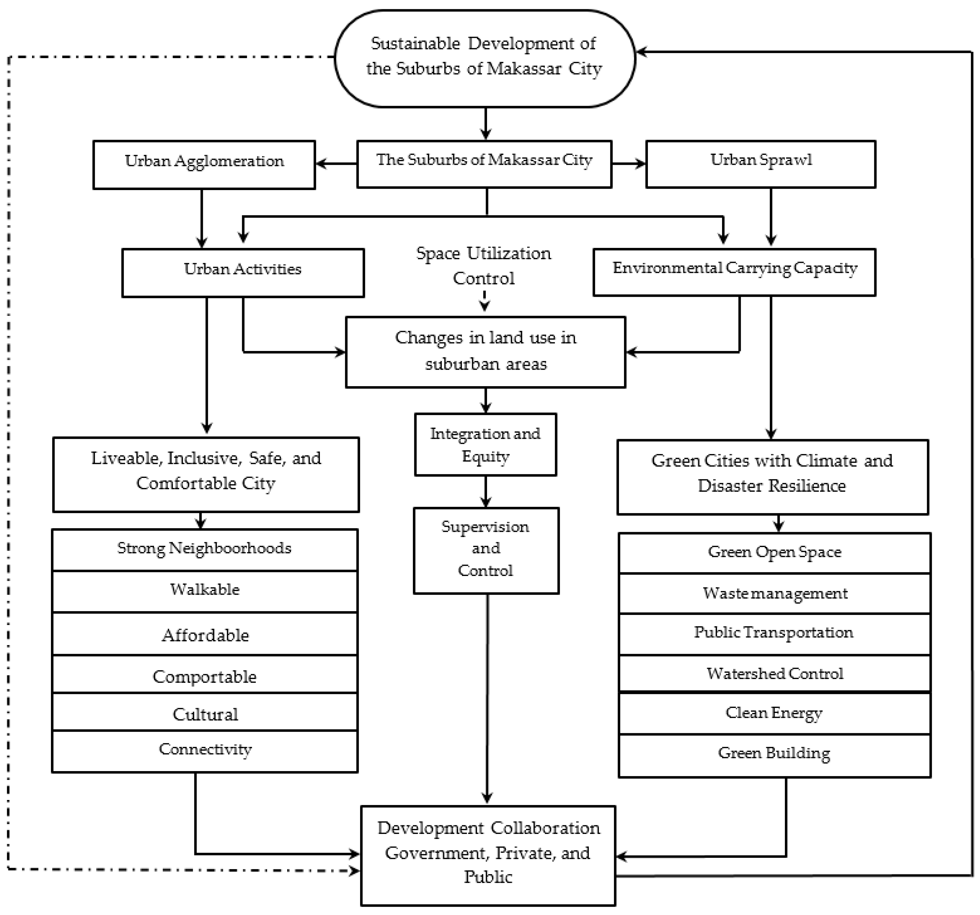
5.2. Sustainability of the Suburbs of Makassar City

The sustainability of the urban system of Makassar City in relation to the handling of urban sprawl, land-use change, and future urban agglomeration, is oriented towards five basic principles, namely environmental, economic, social, and strengthening government capacity in decision making. Several things need to be considered in the formulation of development policies for the suburbs of Makassar City, among others: (1) building public awareness of efforts to save the environment; (2) building equality in accessing urban spatial functions based on economic justice principles to reduce disparities in services between urban areas; (3) ecological sustainability is oriented to the arrangement of the suburban areas based on natural disaster mitigation which is synchronized with global climate change.
Sustainable development in the context of the suburban area is oriented towards four main things as part of efforts to control spatial use, among others: (1) equitable distribution and social justice, in this case reducing inequality in excessive use of natural resources through efforts to equalize land distribution and fulfillment. urban service standards; (2) Respect for diversity, in this case in addition to preserving biodiversity, it is also necessary to anticipate the emergence of discrimination against urban space access towards communal harmony and cultural diversity to prevent segregation in the socio-economic dynamics of society; (3) integrative, in this case, the implementation of the development of the suburban areas guided by the reciprocal relationship between humans and the environment; and (4) long-term perspective, in this case, spatial planning which is oriented towards optimizing the management and utilization of natural resources that can be used in the long term and able to accommodate the interests of the general public. Spatial planning objectives become the basis for decision-making related to government, private sector, and actions community taken [99]. Spatial planning using a cross-sectoral approach aims to balance spatial aspects and land requirements towards environmental, social, and economic sustainability [100]. The results of the analysis that have been carried out illustrate that the development orientation of the suburbs of Makassar City in relation to urban sprawl and urban agglomeration will require development policy support from the government which is oriented towards three main pillars in the sustainability of urban development, namely environmental, economic, and social as part of the direction of development to be achieved, namely equitable development and improvement of community welfare while maintaining the balance of the urban environment. The sustainability of Makassar City development is presented in Figure 7 below.

6. Conclusions

The expansion of the Makassar City area to the suburbs has an impact on land-use changes and the characteristics of the transportation system due to increased socio-economic activities. Urban sprawl in the spatial dynamics of suburban areas has different characteristics and is highly dependent on population density, building density, space capacity, and environmental carrying capacity. The intensity of land-use change in suburban areas is influenced by several factors, namely ease of licensing, changes in land ownership status, and suburbanization. The impact of land-use change contributes to the land-use of water catchment areas, river use areas, and coastal benefit areas due to land reclamation for housing and settlement development needs as well as urban infrastructure. Increased development activities in suburban areas have a positive contribution to river water quality pollution, air pollution, and damage to natural vegetation towards environmental degradation. Development activities that continue to increase, both carried out by the community and developers, are accompanied by the construction of a road network system, in addition to encouraging increased population mobility and increased socio-economic activities towards the integration of the urban system, which is positively associated with urban sprawl in suburban areas. Factors that trigger sprawl in suburban areas, namely low land prices, infrastructure development developed by the government, increased community income, inconsistencies in the implementation of spatial plans, low tax rates, population growth, and preference for community settlements. Urban sprawl tends to develop in district areas with low density in relation to the available land area. Thus, the expansion of urban areas to suburban areas is positively associated with socioeconomic disparities and slum settlements towards spatial segregation and a decrease in environmental quality.
Urban agglomeration in the dynamics of development of Makassar City has an impact on economic growth and is positively associated with changes in land-use, spatial structure, spatial patterns, typology, and morphology of suburban areas towards environmental degradation. Urban agglomeration coupled with urban spatial integration has an impact on agricultural land conversion, changes in people’s lifestyles, urbanization, migration, suburbanization, and socio-economic disparities towards industrialization of suburban areas. The acceleration of the development of Makassar City has an impact on energy mobility and the flow of transportation to the city center is quite high. Urban agglomeration based on growing spatial zoning has an impact on the grouping of housing and settlements, commercial activities, industry, educational facilities, and offices that dominate the area on the main city road corridors towards the integration of the urban system. Thus, urban sprawl, urban agglomeration, changes in land-use, urban activity systems, and transportation systems have a significant effect on the deterioration of the environmental quality of suburban areas. To deal with urban sprawl and urban agglomeration that develops in suburban areas, it will require the support of development policies from the government which is implemented consistently through the following efforts: (1) realizing social justice for all levels of society, (2) conservation of land and watershed resources through efforts to tighten space utilization permits to support the preservation of ecosystem functions; (3) synergizing population density and building density supported by the fulfillment of socio-economic activities; (4) preparation of adequate public transportation facilities, and (5) increasing the welfare of the community towards sustainable development based on community participation.
The sustainability of the urban system of Makassar City as a solution to dealing with urban sprawl, land-use change, and urban agglomeration in the future, is oriented to several basic principles, namely environmental, economic, social, and strengthening government capacity in decision making. Several things that need to be considered in the formulation of development policies for the suburbs of Makassar City, among others: (1) building public awareness of efforts to save the environment; (2) building equality in accessing urban spatial functions based on the principles of economic justice and reducing disparities in services between urban areas; (3) ecological sustainability is oriented to the arrangement of the suburban areas based on natural disaster mitigation which is synchronized with global climate change. Furthermore, the actions needed in developing suburban areas towards sustainable urban development include (a) land stewardship which emphasizes the importance of building ecological ethics to manage and preserve ecosystems; (b) determining the threshold for spatial use based on the management of the built environment and anticipating environmental quality degradation through monitoring and management of waste, air pollution, and depletion of resources in a sustainable manner; (c) interdependence includes not only ecological relationships between species and nature but also economic and cultural relationships at the local and regional levels; (d) economic restructuring by means of expanding employment opportunities for the community in synergy with efforts to preserve the environment; (e) social justice in meeting people’s needs for decent work, education and health services; (f) intergenerational needs that emphasize the need for the long term to improve people’s welfare.
Sustainable development in the suburbs of Makassar City in the future is oriented towards four main things as part of efforts to control spatial use, including: (1) equitable social and economic facilities based on social justice to reduce inequality in excessive use of natural resources and equitable land distribution followed by fulfillment urban service standards; (2) respect for diversity, in this case in addition to preserving biodiversity, it is also necessary to anticipate the emergence of discrimination against urban space access towards community harmony and cultural diversity to prevent segregation in the socio-economic dynamics of society; (3) integrative, in this case the implementation of the development of the suburban areas guided by the reciprocal relationship between humans and the environment, and (4) long-term perspective, in this case is to implement spatial planning that is oriented towards optimizing the management and utilization of natural resources effectively and efficiently for the long term and able to accommodate the interests of the general public.

Author Contributions

B.S., conceptualization; B.S., H.H., and A.S., compiling the research; S.S., F.M., and E.S.R., establishing the study; B.S., H.H.; S.S., and F.M., processing data; A.S., F.M., and E.S.R., contributing to materials/methods/analysis tools; B.S., S.S., and H.H., analyzing data; F.M. and E.S.R., contributing to data checking; B.S., H.H., S.S.; S.S., F.M., and E.S.R., writing and revising concepts. All authors have read and agreed to the published version of the manuscript.

Funding

This research is funded by the Government through the Ministry of Education and Culture of the Republic of Indonesia in the form of research and development grant assistance for universities.

Institutional Review Board Statement

This research was conducted with the approval of the Institute for Research and Community Service (LPPM Bosowa Makassar University) with Contract Number 12/LPPM/VIII/2020 dated 12 August 2020. Furthermore, funding for this research is funded through the Bosowa Makassar University Institute through research and development and has been approved by the Chairperson of the Bosowa University LPPM.

Informed Consent Statement

The results of this study have received approval from the Institute for Research and Community Service at Bosowa University Makassar as outlined in the approval of the Chairperson of LPPM Number 72 / LPPM / IX / 2020.

Data Availability Statement

We fully support open scientific exchange through MDPI in sharing and archiving research data from this study. We fully comply with the provisions that have been set by referring to the established journal guidelines.

Acknowledgments

We are grateful for the participation of stakeholders in contributing ideas and ideas to the implementation of this study. Thank you to the Ministry of Education and Culture of the Republic of Indonesia for their support and grant aid for applied research grants in supporting the research of this study.

Conflicts of Interest

The authors declare no conflict of interest.

Appendix A

Figure A1. Population density of Makassar City by district: (A) in 2006, (B) in 2010, (C) in 2015, and (D) in 2020.
Land 10 00556 g0a1
Figure A2. Comparison of building density in Makassar City: (A) 2006, (B) 2009, (C) 2016, and (D) 2020.
Land 10 00556 g0a2
Figure A3. Differences in distance between districts to CBD locations and sprawl typology of Makassar City. (A) Year 2010, (B) Year 2015, (C) Year 2020, and (D) Distance to CBD.
Land 10 00556 g0a3

References

  1. Legates, R.; Hudalah, D. Peri-urban planning for developing East Asia: Learning from Chengdu, China and Yogyakarta/Kartamantul, Indonesia. J. Urban Aff. 2014, 36 (Supp. 1), 334–353. [Google Scholar] [CrossRef]
  2. Wu, K.; Zhang, H. Land use dynamics, built-up land expansion patterns, and driving forces analysis of the fast-growing Hangzhou metropolitan area, eastern China (1978–2008). Appl. Geogr. 2012, 34, 137–145. [Google Scholar] [CrossRef]
  3. Jiang, Y.; Hou, L.; Shi, T.; Ning, Y. Spatial Zoning Strategy of Urbanization Based on Urban Climate Co-Movement: A Case Study in Shanghai Mainland Area. Sustainability 2018, 10, 2706. [Google Scholar] [CrossRef] [Green Version]
  4. Surya, B.; Ahmad, D.N.A.; Sakti, H.H.; Sahban, H. Land Use Change, Spatial Interaction, and Sustainable Development in the Metropolitan Urban Areas, South Sulawesi Province, Indonesia. Land 2020, 9, 95. [Google Scholar] [CrossRef] [Green Version]
  5. Surya, B.; Ahmad, D.N.A.; Bahrun, R.S.; Saleh, H. Urban farming as a slum settlement solution (study on slum settlements in Tanjung Merdeka Village, Makassar City). IOP Conf. Ser. Earth Environ. Sci. 2020, 562, 012006. [Google Scholar] [CrossRef]
  6. Švajlenka, J.; Kozlovská, M. Houses Based on Wood as an Ecological and Sustainable Housing Alternative-Case Study. Sustainability 2018, 10, 1502. [Google Scholar] [CrossRef] [Green Version]
  7. Zhang, Y.; Song, R.; van Nes, R.; He, S.; Yin, W. Identifying Urban Structure Based on Transit-Oriented Development. Sustainability 2019, 11, 7241. [Google Scholar] [CrossRef] [Green Version]
  8. Anas, A.; Arnott, R.J.; Small, K.A. Urban spatial structure. J. Econ. Lit. 1998, 36, 1426–1464. [Google Scholar]
  9. Garcia-López, M.À.; Muñiz, I. Urban spatial structure, agglomeration economies, and economic growth in Barcelona: An intra-metropolitan perspective. Pap. Reg. Sci. 2013, 92, 515–534. [Google Scholar] [CrossRef]
  10. Kloosterman, R.C.; Musterd, S. The polycentric Urban region: Towards a research Agenda. Urban Stud. 2001, 38, 623–633. [Google Scholar] [CrossRef]
  11. Work Bank. Laju Urbanisasi di Indonesia. 2019. Available online: https://www.google.com/search?q=Urbanisasi+di+Indonesia+(Work+Bank%2C+2019)&oq=Urbanisasi+di+Indonesia+(Work+Bank%2C+2019)&aqs=chrome..69i57.18168j0j8&sourceid=chrome&ie=UTF-8 (accessed on 3 March 2020).
  12. Asian Development Bank. Annual Report. 2019. Available online: https://www.adb.org/sites/default/files/institutional-document/650011/adb-annual-report-2019.pdf (accessed on 3 December 2020).
  13. Word Bank. Kajian Kebijakan Pembangunan 2014. Indonesia: Menghindari Perangkap. Available online: http://documents.worldbank.org/curated/en/132131468051887925/pdf/889290REVISED00y0review020140bahasa.pdf (accessed on 3 March 2020).
  14. Handayani, W.; Chigbu, U.E.; Rudiarto, I.; Putri, I.H.S. Urbanization and Increasing Flood Risk in the Northern Coast of Central Java—Indonesia: An Assessment towards Better Land Use Policy and Flood Management. Land 2020, 9, 343. [Google Scholar] [CrossRef]
  15. Egidi, G.; Cividino, S.; Vinci, S.; Sateriano, A.; Salvia, R. Towards Local Forms of Sprawl: A Brief Reflection on Mediterranean Urbanization. Sustainability 2020, 12, 582. [Google Scholar] [CrossRef] [Green Version]
  16. Huang, D.; Tan, X.; Liu, T.; Chu, E.; Kong, F. Effects of Hierarchical City Centers on the Intensity and Direction of Urban Land Expansion: A Case Study of Beijing. Land 2020, 9, 312. [Google Scholar] [CrossRef]
  17. KungLai, S. Effects of land use plans on urban development: A property rights approach. J. Urban Manag. 2020, 9, 1–5. [Google Scholar] [CrossRef]
  18. Kurda, K.P.; Vavrouchová, H. Land Cover Change and Landscape Transformations (2000–2018) in the Rural Municipalities of the Upper Silesia-Zagł ˛ebie Metropolis. Sustainability 2020, 12, 9911. [Google Scholar] [CrossRef]
  19. Surya, B.; Menne, F.; Sabhan, H.; Suriani, S.; Abubakar, H.; Idris, M. Economic Growth, Increasing Productivity of SMEs, and Open Innovation. J. Open Innov. Technol. Mark. Complex 2021, 7, 20. [Google Scholar] [CrossRef]
  20. Ashik, F.R.; Mim, S.A.; Neema, M.N. Towards vertical spatial equity of urban facilities: An integration of spatial and aspatial accessibility. J. Urban Manag. 2020, 9, 77–92. [Google Scholar] [CrossRef]
  21. Assaf, C.; Adams, C.; Ferreira, F.F.; França, H. Land use and cover modeling as a tool for analyzing nature conservation policies – A case study of Juréia-Itatins. Land Use Policy 2020, 100, 104895. [Google Scholar] [CrossRef]
  22. Carruthers, J.I.; Ulfarrson, G.F. Urban Sprawl and the Cost of Public Services. Environ. Plan. B Urban Anal. City Sci. 2003, 30, 503–522. [Google Scholar] [CrossRef]
  23. Zerhouny, M.; Fadil, A.; Hakdaoui, M. Underground Space Utilization in the Urban Land-Use Planning of Casablanca (Morocco). Land 2018, 7, 143. [Google Scholar] [CrossRef] [Green Version]
  24. Wojewodzic, T.; Janus, J.; Dacko, M.; Pijanowski, J.; Taszakowski, J. Measuring the effectiveness of land consolidation: An economic approach based on selected case studies from Poland. Land Use Policy 2021, 100, 104888. [Google Scholar] [CrossRef]
  25. Cheng, J. Analysis of commercial land leasing of the district governments of Beijing in China. Land Use Policy 2021, 100, 104881. [Google Scholar] [CrossRef]
  26. Hlaváˇcek, P.; Kopáˇcek, M.; Horáˇcková, L. Impact of Suburbanisation on Sustainable Development of Settlements in Suburban Spaces: Smart and New Solutions. Sustainability 2019, 11, 7182. [Google Scholar] [CrossRef] [Green Version]
  27. Surya, B.; Hadijah, H.; Suriani, S.; Baharuddin, B.; Fitriyah, A.T.; Menne, F.; Rasyidi, E.S. Spatial Transformation of a New City in 2006–2020: Perspectives on the Spatial Dynamics, Environmental Quality Degradation, and Socio—Economic Sustainability of Local Communities in Makassar City, Indonesia. Land 2020, 9, 324. [Google Scholar] [CrossRef]
  28. Zhang, Q.; Zhang, H.; Zhao, D.; Cheng, B.; Yu, C.; Yang, Y. Does Urban Sprawl Inhibit Urban Eco-Efficiency? Empirical Studies of Super-Efficiency and Threshold Regression Models. Sustainability 2019, 11, 5598. [Google Scholar] [CrossRef] [Green Version]
  29. Alipbeki, O.; Alipbekova, C.; Sterenharz, A.; Toleubekova, Z.; Makenova, S.; Aliyev, M.; Mineyev, N. Analysis of Land-Use Change in Shortandy District in Terms of Sustainable Development. Land 2020, 9, 147. [Google Scholar] [CrossRef]
  30. Vaidyanathan, V.; King, R.A.; de Jong, M. Understanding urban transportation in India as polycentric system. Policy Soc. 2013, 32, 175–185. [Google Scholar] [CrossRef] [Green Version]
  31. Surya, B.; Hamsina, H.; Ridwan, R.; Baharuddin, B.; Menne, F.; Fitriyah, A.T.; Rasyidi, E.S. The Complexity of Space Utilization and Environmental Pollution Control in the Main Corridor of Makassar City, South Sulawesi, Indonesia. Sustainability 2020, 12, 9244. [Google Scholar] [CrossRef]
  32. Surya, B. The Dynamics of Spatial Structure and Spatial Pattern Changes at the Fringe Area of Makassar City. Indones. J. Geogr. 2015, 47, 11–19. [Google Scholar] [CrossRef]
  33. Tian, Y. Mutualistic Pattern of Intra-Urban Agglomeration, and Impact Analysis: A Case Study of 11 Urban Agglomerations of Mainland China. ISPRS Int. J. Geo-Inf. 2020, 9, 565. [Google Scholar] [CrossRef]
  34. Surya, B. Change Phenomena of Spatial Physical in the Dynamics of Development in Urban Fringe Area. Indones. J. Geogr. 2016, 48, 118–134. [Google Scholar] [CrossRef] [Green Version]
  35. Zhao, Y.; Zhang, G.; Zhao, H. Spatial Network Structures of Urban Agglomeration Based on the Improved Gravity Model: A Case Study in China’s Two Urban Agglomerations. Complexity 2021, 6651444. [Google Scholar] [CrossRef]
  36. Han, H.; Li, H. Coupling Coordination Evaluation between Population and Land Urbanization in Ha-Chang Urban Agglomeration. Sustainability 2020, 12, 357. [Google Scholar] [CrossRef] [Green Version]
  37. Shen, N.; Zhao, Y.; Wang, Q. Diversified Agglomeration, Specialized Agglomeration, and Emission Reduction Effect—A Nonlinear Test Based on Chinese City Data. Sustainability 2018, 10, 2002. [Google Scholar] [CrossRef] [Green Version]
  38. Ma, F.; Wang, Z.; Sun, Q.; Yuen, K.F.; Zhang, Y.; Xue, H.; Zhao, S. Spatial–Temporal Evolution of Urban Resilience and Its Influencing Factors: Evidence from the Guanzhong Plain Urban Agglomeration. Sustainability 2020, 12, 2593. [Google Scholar] [CrossRef] [Green Version]
  39. Surya, B.; Saleh, H.; Suriani, S.; Sakti, H.H.; Hadijah, H.; Idris, M. Environmental Pollution Control and Sustainability Management of Slum Settlements in Makassar City, South Sulawesi, Indonesia. Land 2020, 9, 279. [Google Scholar] [CrossRef]
  40. Yao, Z.; Ye, K.; Xiao, L.; Wang, X. Radiation Effect of Urban Agglomeration’s Transportation Network: Evidence from Chengdu–Chongqing Urban Agglomeration, China. Land 2021, 10, 520. [Google Scholar] [CrossRef]
  41. Nugmanova, A.; Arndt, W.H.; Hossain, M.A.; Kim, J.R. Effectiveness of Ring Roads in Reducing Traffic Congestion in Cities for Long Run: Big Almaty Ring Road Case Study. Sustainability 2019, 11, 4973. [Google Scholar] [CrossRef] [Green Version]
  42. Surya, B.; Syafri, S.; Sahban, H.; Sakti, H.H. Natural Resource Conservation Based on Community Economic Empowerment: Perspectives on Watershed Management and Slum Settlements in Makassar City, South Sulawesi, Indonesia. Land 2020, 9, 104. [Google Scholar] [CrossRef] [Green Version]
  43. Forsyth, A.; Peiser, R. Lessons from planned resettlement and new town experiences for avoiding climate sprawl. Landsc. Urban Plan. 2021, 205, 103957. [Google Scholar] [CrossRef]
  44. Han, W.; Zhang, Y.; Cai, J.; Ma, E. Does Urban Industrial Agglomeration Lead to the Improvement of Land Use Efficiency in China? An Empirical Study from a Spatial Perspective. Sustainability 2019, 11, 986. [Google Scholar] [CrossRef] [Green Version]
  45. Ahrens, A.; Lyons, S. Changes in Land Cover and Urban Sprawl in Ireland From a Comparative Perspective Over 1990–2012. Land 2019, 8, 16. [Google Scholar] [CrossRef] [Green Version]
  46. Guyot, M.; Araldi, A.; Fusco, G.; Thomas, I. The urban form of Brussels from the street perspective: The role of vegetation in the definition of the urban fabric. Landsc. Urban Plan. 2021, 205, 103947. [Google Scholar] [CrossRef]
  47. Morollón, F.R.; Yserte, R.G. Recent Literature about Urban Sprawl: A Renewed Relevance of the Phenomenon from the Perspective of Environmental Sustainability. Sustainability 2020, 12, 6551. [Google Scholar] [CrossRef]
  48. Al Jarah, S.H.; Zhou, B.; Abdullah, R.J.; Lu, Y.; Yu, W. Urbanization and Urban Sprawl Issues in City Structure: A Case of the Sulaymaniah Iraqi Kurdistan Region. Sustainability 2019, 11, 485. [Google Scholar] [CrossRef] [Green Version]
  49. Feng, D.; Li, J.; Li, X.; Zhang, Z. The Effects of Urban Sprawl and Industrial Agglomeration on Environmental Efficiency: Evidence from the Beijing–Tianjin–Hebei Urban Agglomeration. Sustainability 2019, 11, 3042. [Google Scholar] [CrossRef] [Green Version]
  50. Knox, P.; McCarthy, L.M. Urbanization: An Introduction to Urban Geography, 3rd ed.; Pearson Educ. Ltd.: Harlow, UK, 2014; pp. 1–142. Available online: https://files.pearsoned.de/inf/ext/9781292047935 (accessed on 23 November 2020).
  51. The ASEAN Secretariat. Asean Sustainable Urbanisation Strategy. Association of Southeast Asian Nations (ASEAN) 2018. Available online: https://asean.org/storage/2018/11/ASEAN-Sustainable-Urbanisation-Strategy-ASUS.pdf (accessed on 5 May 2020).
  52. Izakoviˇcová, Z.; Mederly, P.; Petroviˇc, F. Long-Term Land Use Changes Driven by Urbanisation and Their Environmental Effects (Example of Trnava City, Slovakia). Sustainability 2017, 9, 1553. [Google Scholar] [CrossRef] [Green Version]
  53. Rousta, I.; Sarif, M.O.; Gupta, R.D.; Olafsson, H.; Ranagalage, M.; Murayama, Y.; Zhang, H.; Mushore, T.D. Spatiotemporal Analysis of Land Use/Land Cover and Its Effects on Surface Urban Heat Island Using Landsat Data: A Case Study of Metropolitan City Tehran (1988–2018). Sustainability 2018, 10, 4433. [Google Scholar] [CrossRef] [Green Version]
  54. Zhang, Y.; Xie, H. Interactive Relationship among Urban Expansion, Economic Development, and Population Growth since the Reform and Opening up in China: An Analysis Based on a Vector Error Correction Model. Land 2019, 8, 153. [Google Scholar] [CrossRef] [Green Version]
  55. Surya, B. Spatial Articulation, and Coexistence of Mode of Production in the Dynamics of Development at The Urban Fringe of Makassar City. J. Eng. Appl. Sci. 2015, 10, 214–222. [Google Scholar] [CrossRef]
  56. Barton, J.R.; Ramírez, M.I. The Role of Planning Policies in Promoting Urban Sprawl in Intermediate Cities: Evidence from Chile. Sustainability 2019, 11, 7165. [Google Scholar] [CrossRef] [Green Version]
  57. Gao, J.; Wei, Y.D.; Chen, W.; Yenneti, K. Urban Land Expansion and Structural Change in the Yangtze River Delta, China. Sustainability 2015, 7, 10281–10307. [Google Scholar] [CrossRef] [Green Version]
  58. Surya, B. Inequility of Space Reproduction Control and Urban Slum Area Management Sustainability (Case Study: Slum Area of Buloa Urban Village in Makassar City). J. Eng. Appl. Sci. 2018, 13, 6033–6042. [Google Scholar] [CrossRef]
  59. Surya, B.; Saleh, H.; Remmang, H. Economic Gentrification and Socio-Cultural Transformation Metropolitan Suburban of Mamminasata. J. Eng. Appl. Sci. 2018, 13, 6072–6084. [Google Scholar] [CrossRef]
  60. Jiang, S.; Ferreira, J.; Gonzalez, M.C. Discovering urban spatial-temporal structure from human activity patterns. In Proceedings of the ACM SIGKDD International Workshop on Urban Computing, Beijing, China, 12 August 2012; pp. 95–102. [Google Scholar] [CrossRef] [Green Version]
  61. Hernita, H.; Surya, B.; Perwira, I.; Abubakar, H.; Idris, M. Economic Business Sustainability and Strengthening Human Resource Capacity Based on Increasing the Productivity of Small and Medium Enterprises (SMEs) in Makassar City, Indonesia. Sustainability 2021, 13, 3177. [Google Scholar] [CrossRef]
  62. Surya, B. Optimization of Function and Role of Traditional Markets in Urban Development System of Ketapang City (a case study: Range Sentap Market, Delta Pawan Subdistrict, Ketapang city). World Appl. Sci. J. 2015, 33, 1457–1471. [Google Scholar] [CrossRef]
  63. Surya, B.; Saleh, H. Transformation of metropolitan suburban area (a study on new town development in Moncongloe-Pattalassang Metropolitan Maminasata). IOP Conf. Ser. Earth Environ. Sci. 2018, 202, 012027. [Google Scholar] [CrossRef] [Green Version]
  64. Pratomo, R.A.; Samsura, D.A.A.; van der Krabben, E. Transformation of Local People’s Property Rights Induced by New Town Development (Case Studies in Peri-Urban Areas in Indonesia). Land 2020, 9, 236. [Google Scholar] [CrossRef]
  65. Wang, Z.; Zhao, J.; Lin, S.; Liu, Y. Identification of Industrial Land Parcels, and Its Implications for Environmental Risk Management in the Beijing–Tianjin–Hebei Urban Agglomeration. Sustainability 2020, 12, 174. [Google Scholar] [CrossRef] [Green Version]
  66. Surya, B. Social Change, Spatial Articulation in the Dynamics of Boomtown Construction and Development (Case Satudy of Metro Tanjung Bunga Boomtown, Makassar). Mod. Appl. Sci. 2014, 8, 238–245. [Google Scholar] [CrossRef] [Green Version]
  67. Mangi, M.Y.; Yue, Z.; Kalwar, S.; Lashari, Z.A. Comparative Analysis of Urban Development Trends of Beijing and Karachi Metropolitan Areas. Sustainability 2020, 12, 451. [Google Scholar] [CrossRef] [Green Version]
  68. Boyer, R.H.W.; Peterson, N.D.; Arora, P.; Caldwell, K. Five Approaches to Social Sustainability and an Integrated Way Forward. Sustainability 2016, 8, 878. [Google Scholar] [CrossRef] [Green Version]
  69. Denzin, N.K.; dan Lincoln, Y.S. (Eds.) Handbook of Qualitative Research; Terjemahan Dariyatno dkk; Pustaka Pelajar: Jogjakarta, Indonesia, 2009; ISBN 978-602-84. Available online: https://openlibrary.telkomuniversity.ac.id/pustaka/9769/handbook-of-qualitative-research.html (accessed on 20 April 2020).
  70. Huang, D.; Liu, Z.; Zhao, X. Monocentric or Polycentric? The Urban Spatial Structure of Employment in Beijing. Sustainability 2015, 7, 11632–11656. [Google Scholar] [CrossRef] [Green Version]
  71. BPS Makassar City. Kota Makassar Dalam Angka. 2019. Available online: https://makassarkota.bps.go.id/publication/2019/08/16/4ca03301b8e2b8414e33f6a3/kota-makassar-dalam-angka-2019.html (accessed on 13 February 2020).
  72. Malmberg, A.; Maskell, P. Towards and Explanation of Industry Agglomeration and Regional Spezialitation. Eur. Plan. Stud. 1997, 5, 25–41. [Google Scholar] [CrossRef]
  73. Bhatta, B.; Saraswati, S.; Bandyopadhyay, D. Urban Sprawl Measurement From Remote Sensing Data. Appl. Geogr. 2010, 30, 731–740. [Google Scholar] [CrossRef]
  74. Viljoen, C.; Lowies, B.; Lushington, K.; McGreal, S. Female perspectives on housing quality and household characteristics, perceptions and challenges: Evidence from Australia. Habitat Int. 2020, 105, 102276. [Google Scholar] [CrossRef]
  75. Schneider, C.; Achilles, B.; Merbitz, H. Urbanity and Urbanization: An Interdisciplinary Review Combining Cultural and Physical Approaches. Land 2014, 3, 105–130. [Google Scholar] [CrossRef] [Green Version]
  76. Monteiro, F.F.; Gonçalves, W.A.; Andrade, L.M.B.; Villavicencio, L.M.M.; Silva, C.M.S. Assessment of Urban Heat Islands in Brazil based on MODIS remote sensing data. Urban Clim. 2021, 35, 100726. [Google Scholar] [CrossRef]
  77. Surya, B.; Saleh, H.; Hamsina, H.; Idris, M.; Ahmad, D.N.A. Rural Agribusiness-based Agropolitan Area Development and Environmental Management Sustainability: Regional Economic Growth Perspectives. Int. J. Energy Econ. Policy 2021, 1, 142–157. [Google Scholar] [CrossRef]
  78. Creswell, J.W. Research Design Pendekatan Metode Kualitatif, Kuantitatif, dan Campuran; Pustaka Pelajar: Jakarta, Indonesia, 2016; ISBN 9786022295846. [Google Scholar]
  79. Sugiyono. Metode Penelitian Kuantitatif, Kualitatif dan R&D. Bandung: PT Alfabet. 2016. Available online: http://cvalfabeta.com/product/metode-penelitian-kuantitatif-kualitatif-dan-rd-mpkk/ (accessed on 5 May 2020).
  80. Isaac, S.; Michael, W.B. Handbook in Research and Evaluation; EDITS Publishers: San Diego, CA, USA, 1981; Volume 234. [Google Scholar] [CrossRef]
  81. Zandi, R.; Zanganeh, M.; Akbari, E. Zoning and spatial analysis of poverty in urban areas (Case Study: Sabzevar City-Iran). J. Urban Manag. 2019, 8, 342–354. [Google Scholar] [CrossRef]
  82. Das, M.; Das, A. Dynamics of Urbanization and its impact on Urban Ecosystem Services (UESs): A study of a medium size town of West Bengal, Eastern India. J. Urban Manag. 2019, 8, 420–434. [Google Scholar] [CrossRef]
  83. Surya, B.; Muhibuddin, A.; Suriani, S.; Rasyidi, E.S.; Baharuddin, B.; Fitriyah, A.T.; Abubakar, H. Economic Evaluation, Use of Renewable Energy, and Sustainable Urban Development Mamminasata Metropolitan, Indonesia. Sustainability 2021, 13, 1165. [Google Scholar] [CrossRef]
  84. Syafri, S.; Surya, B.; Ridwan, R.; Bahri, S.; Rasyidi, E.S.; Sudarman, S. Water Quality Pollution Control and Watershed Management Based on Community Participation in Maros City, South Sulawesi, Indonesia. Sustainability 2020, 12, 10260. [Google Scholar] [CrossRef]
  85. Brueckner, J.K.; Thisse, J.F.; Zenou, Y. Why is central Paris rich and downtown Detroit poor? Eur. Econ. Rev. 1999, 43, 91–107. [Google Scholar] [CrossRef]
  86. Hwang, U.; Woo, M. Analysis of Inter-Relationships between Urban Decline and Urban Sprawl in City-Regions of South Korea. Sustainability 2020, 12, 1656. [Google Scholar] [CrossRef] [Green Version]
  87. Surya, B.; Syafri, S.; Hadijah, H.; Baharuddin, B.; Fitriyah, A.T.; Sakti, H.H. Management of Slum-Based Urban Farming and Economic Empowerment of the Community of Makassar City, South Sulawesi, Indonesia. Sustainability 2020, 12, 7324. [Google Scholar] [CrossRef]
  88. Surya, B.; Suriani, S.; Menne, F.; Abubakar, H.; Idris, M.; Rasyidi, E.S.; Remmang, H. Community Empowerment and Utilization of Renewable Energy: Entrepreneurial Perspective for Community Resilience Based on Sustainable Management of Slum Settlements in Makassar City, Indonesia. Sustainability 2021, 13, 3178. [Google Scholar] [CrossRef]
  89. Yuan, F.; Wei, Y.D.; Wu, J.W. Amenity effects of urban facilities on housing prices in China: Accessibility, scarcity, and urban spaces. Cities 2020, 96, 102433. [Google Scholar] [CrossRef]
  90. Wang, Y.; Liu, K. Evolution of Urban Socio-Spatial Structure in Modern Times in Xi’an, China. Sustainability 2017, 9, 1935. [Google Scholar] [CrossRef] [Green Version]
  91. Krier, R. Urband Space; John Wiley & Sons: Hoboken, NJ, USA, 1979. [Google Scholar]
  92. Saleh, H.; Surya, B.; Hamsina, H. Implementation of Sustainable Development Goals to Makassar Zero Waste and Energy Source. Int. J. Energy Econ. Policy 2020, 10, 530–538. [Google Scholar] [CrossRef]
  93. Baker, S. Sustainable Development; Routledge: London, UK, 2006; p. 245. [Google Scholar]
  94. Bounoua, L.; Fathi, N.; El Berkaoui, M.; El Ghazouani, L.; Messouli, M. Assessment of Sustainability Development in Urban Areas of Morocco. Urban Sci. 2020, 4, 18. [Google Scholar] [CrossRef] [Green Version]
  95. Dushkova, D.; Haase, D. Not Simply Green: Nature-Based Solutions as a Concept and Practical Approach for Sustainability Studies and Planning Agendas in Cities. Land 2020, 9, 19. [Google Scholar] [CrossRef] [Green Version]
  96. Surya, B. Spatial Interaction Pattern and the Process of City Activity Formation System (Case study, Ternate City, Tidore Archipelago City and Sofifi City of North Maluku, Indonesia). Res. J. Appl. Sci. 2015, 10, 880–892. [Google Scholar] [CrossRef]
  97. Teferi, Z.A.; Newman, P. Slum Regeneration and Sustainability: Applying the Extended Metabolism Model and the SDGs. Sustainability 2017, 9, 2273. [Google Scholar] [CrossRef] [Green Version]
  98. Ageev, I.A.; Ageeva, V.V. Urban lifestyle as an element of consumption ideal and economic wellbeing: Meaning-changing transformation from Soviet period to modernity. Procedia Soc. Behav. Sci. 2015, 166, 24–29. [Google Scholar] [CrossRef] [Green Version]
  99. Saleh, H.; Surya, B.; Ahmad, D.N.A.; Manda, D. The Role of Natural and Human Resources on Economic Growth and Regional Development: With Discussion of Open Innovation Dynamics. J. Open Innov. Technol. Mark. Complex. 2020, 6, 103. [Google Scholar] [CrossRef]
  100. Lankao, P.R.; Gnatz, D.M.; Wilhelmi, O.; Hayden, M. Urban Sustainability and Resilience: From Theory to Practice. Sustainability 2016, 8, 1224. [Google Scholar] [CrossRef] [Green Version]
Figure 1. Conceptual framework of urban spawl and land-use change in Makassar City. Source: Author elaborator.
Land 10 00556 g001
Figure 2. Makassar City as a study location.
Land 10 00556 g002
Figure 3. Flowchart of the methodology. Source: Author elaborator.
Land 10 00556 g003
Figure 4. The development of Makassar City is linear and concentric.
Land 10 00556 g004
Figure 5. Decreasing environmental quality in Makassar City. Source: Primary data.
Land 10 00556 g005
Figure 6. Comparison of the urban sprawl of Makassar City: (A) 2006, (B) 2009, (C) 2016, and (D) 2020.
Land 10 00556 g006
Figure 7. Sustainable development of the suburbs of Makassar City. Source: Author’s elaboration.
Land 10 00556 g007
Table 1. Total population of Makassar City and the location distance to the city center.
NumberDistrictVillageArea (Hectare)Total Population (Person)Distance to City Center (Kilometers)
1Makassar1326,53685,5152–5
2Mariso928,18960,4992–5
3Tamalate10241,359205,5412–5
4Panakukang10156,765149,6645–10
5Tallo1496,153140,3302–5
6Bontoala8173857,1972–5
7Ujung Tanah813,63129,0542–5
8Sangkarrang Islands3968814,53110–20
9Mamajang925,08761,4522–5
10Rappocini9109,628170,1215–10
11UjungPandang728,45919,0542–5
12Wajo820,47231,4532–5
13Manggala62,291,46149,4872–5
14Biringkanaya73,678,17220,4565–10
15Tamalanrea63,857,08115,8435–10
Source: BPS Makassar City [71].
Table 2. Summary of research data and data collection methods.
NumberResearch QuestionResearch VariableIndicatorData SourceData Collection Instruments
1How do land-use changes and urban sprawl work as determinants of environmental quality degradation in suburban areas.Land-Use ChangeLand-use change is measured by indicators: spatial function, built-up land area, and land-use patterns.Observation, survey, and documentation.Field notes, base map of location, questionnaire, and Map of Makassar City land-use data (2006–2020)
Urban SprawlUrban sprawl is measured by indicators: population density, building density, typology, built-in land area ratio, building grouping, and the distance of settlements to the city center.Observation, survey, and documentation.Field notes, questionnaires, population density map (2006–2020), building density map (2006–2020), Makassar city development area map (2006–2020), new area development area map of suburban areas
Environmental Quality DecreaseThe decline in environmental quality is measured by the following indicators: source of pollution, level of pollution, and carrying capacity of the environment.Observation, and survey.Field notes, questionnaires, location base maps, and cameras
2How do urban sprawl, urban agglomeration, land-use change, urban activity system, and transportation system affect the environmental quality degradation in suburban areas.Urban SprawlUrban sprawl is measured by indicators: population density, building density, typology, built-in land area ratio, building grouping, and the distance of settlements to the city center.Observation, survey, and documentation.Field notes, questionnaires, population density map (2006–2020), building density map (2006–2020), Makassar city development area map (2006–2020), new area development area map of suburban areas.
Urban AgglomerationUrban agglomeration is measured by indicators: housing and settlement grouping, trade and service grouping, industrial grouping, educational activity grouping, urban growth, and urban spatial zoning.Observation and survey.Field notes, questionnaires, base maps of city activity locations, development maps of suburban areas, and spatial zoning maps.
Land-use changeLand-use change is measured by indicators: spatial function, built-up land area, and land-use patterns.Observation, survey, and documentation.Field notes, base map of location, questionnaire, and Map of Makassar City land-use data (2006–2020).
Activity SystemThe city activity system is measured by indicators: spatial function, built area, movement system, and facilities and infrastructure.Observation and survey.Field notes, base maps of location, questionnaires, and cameras.
Environmental Quality DecreaseThe decline in environmental quality is measured by the following indicators: source of pollution, level of pollution, and carrying capacity of the environment.Observation, and survey.Field notes, questionnaires, location base maps, and cameras.
Table 3. Number of respondents in this study.
NumberDistrictTotal Population (Person)Number of Respondents
1Makassar85,51510
2Mariso60,4996
3Tamalate205,54160
4Panakukang149,66445
5Tallo140,33046
6Bontoala57,1976
7Ujung Tanah29,0544
8Sangkarrang Islands14,5312
9Mamajang61,4526
10Rappocini170,12160
11UjungPandang19,0543
12Wajo31,4534
13Manggala149,48745
14Biringkanaya220,45673
15Tamalanrea115,84330
Source: Author’s elaboration.
Table 4. Space utilization of Makassar City for the period 2006–2020.
NumberType of ActivitySpace Utilization (Hectares)
Year 2006–2010Percentage (%)Year 2015–2020Percentage (%)
1Commercial7.340.04266,14315.14
2Education27.730.16182,8951.04
3Settlement786,18144.7310,589.3137.97
4Health5.210.03112,1490.64
5Offices5.770.03139,1550.79
6Sports facilities53.390.30621,6973.54
7Social facilities18.770.114,349,69324.75
8Rice fields and mixed gardens640,96336.47528,9453.01
Source: Author elaborator, map(c) 2019 Google.
Table 5. Comparison of urban sprawl typology in Makassar City in 2006, 2010, and 2020.
ParameterQuantificationTypology
Population DensityYear 2006Year 2010Year 2020
High24.000–34.000111, 2
Moderate13.000–24.0001, 21, 22
Low0–13.0001, 2, 31, 2, 31, 2, 3
Building Density
High79–100111
Moderate59–79-22
Low0–591, 2, 32, 33
Distance to City Center (CBD)
Far7001–12.0002, 333
Moderate3.000–7.0001, 21, 2, 31, 2, 3
Near0–3.000111
Development within Road Network Coverage
Affordable0.9–1.001, 21, 21
Quite Affordable0.8–0.91, 2, 31, 2, 31, 2
Unreachable0.7–0.8333
The Pattern of Development Is Irregular
High1.200–1.900-33
Moderate600–1.20031, 31, 2
Low200–6001, 21, 21
Source: Analysis results.
Table 6. Comparison of urban agglomerations based on spatial zones in Makassar City.
Urban AgglomerationCity Center Area (CBD)Transition ZoneFringe Zone
Land Area (ha)% of CBD AreaLand Area (ha)% of Transition Zone AreaLand Area (ha)% to Area of Suburban Zone
Settlement510.3465.294252.4530.751889.748.90
Offices5.770.740.040.000.000.00
Education5.630.72152.901.1124.360.11
Trading101.9213.04180.531.3125.670.12
Industry0.000.00219.801.59401.901.89
Hotels and Tourist Facilities32.444.15117.400.8521.260.10
Source: Author elaborator, Map © 2021 Google.
Table 7. Summary of test results for the significance of multiple regression coefficients.
CorrelationCoefficientErrort-Countt-Table
βSbi
Urban Sprawl to environmental degradation (ryx1)0.1910.0672.8721.84
Urban agglomeration to environmental degradation (ryx2)0.1380.0532.8541.84
Land-use change to environmental quality degradation (ryx3)0.4060.0974.1841.84
City activity system to environmental quality degradation (ryx4)0.2010.0692.6891.84
Transportation system to environmental degradation (ryx5)0.1320.0652.6521.84
Source VariantSum of Squares (JK)Free Degrees (db)Average of the Sum of the Squares (RJK)F-CountF-Table
α = 0.05
Regression
Residue
32,504
1458
7
12
6.547
0.076
86,1446.76
Total33,96219---
RR2db1db2F-countF-table
0.9270.85971286,1446.76
Source: Analysis results.
Publisher’s Note: MDPI stays neutral with regard to jurisdictional claims in published maps and institutional affiliations.

