Article

Key Challenges for Land Use Planning and Its Environmental Assessments in the Abuja City-Region, Nigeria

by
Evidence Chinedu Enoguanbhor
1,2,*,
Florian Gollnow
3,
Blake Byron Walker
4,
Jonas Ostergaard Nielsen
1,2 and
Tobia Lakes
1,2
1
Institute of Geography, Humboldt University of Berlin, Unter den Linden 6, 10099 Berlin, Germany
2
Integrative Research Institute on Transformations of Human-Environment Systems, Humboldt University of Berlin, Unter den Linden 6, 10099 Berlin, Germany
3
Department of Earth & Environment, Boston University, 685 Commonwealth Avenue, Boston, MA 02215, USA
4
Institute for Geography, Friedrich-Alexander Universität Erlangen-Nürnberg, Wetterkreuz 15, 91058 Erlangen, Germany
*
Author to whom correspondence should be addressed.
Land 2021, 10(5), 443; https://doi.org/10.3390/land10050443
Submission received: 29 March 2021 / Revised: 17 April 2021 / Accepted: 18 April 2021 / Published: 21 April 2021
(This article belongs to the Section Urban Contexts and Urban-Rural Interactions)

Abstract

:
Land use planning as strategic instruments to guide urban dynamics faces particular challenges in the Global South, including Sub-Saharan Africa, where urgent interventions are required to improve urban and environmental sustainability. This study investigated and identified key challenges of land use planning and its environmental assessments to improve the urban and environmental sustainability of city-regions. In doing so, we combined expert interviews and questionnaires with spatial analyses of urban and regional land use plans, as well as current and future urban land cover maps derived from Geographic Information Systems and remote sensing. By overlaying and contrasting land use plans and land cover maps, we investigated spatial inconsistencies between urban and regional plans and the associated urban land dynamics and used expert surveys to identify the causes of such inconsistencies. We furthermore identified and interrogated key challenges facing land use planning, including its environmental assessment procedures, and explored means for overcoming these barriers to rapid, yet environmentally sound urban growth. The results illuminated multiple inconsistencies (e.g., spatial conflicts) between urban and regional plans, most prominently stemming from conflicts in administrative boundaries and a lack of interdepartmental coordination. Key findings identified a lack of Strategic Environmental Assessment and inadequate implementation of land use plans caused by e.g., insufficient funding, lack of political will, political interference, corruption as challenges facing land use planning strategies for urban and environmental sustainability. The baseline information provided in this study is crucial to improve strategic planning and urban/environmental sustainability of city-regions in Sub-Saharan Africa and across the Global South, where land use planning faces similar challenges to address haphazard urban expansion patterns.

1. Introduction

Land use planning strategy, which is a deliberate process of defining land for various uses to balance social, economic, and environmental goals [1,2], is an approach for improving urban and environmental sustainability [3,4,5,6]. In this context, environmental sustainability is a condition for meeting the needs of current and future generations without jeopardizing the current and future health of natural ecosystems [7]. The land use planning process varies widely at various scales, but the general process includes defining the goal and objectives, data collection and analysis, plan formulation, negotiation and decision-making, implementation, and monitoring and updating [8].
Land use planning strategies have not been able to effectively address environmental sustainability problems (e.g., degradation of environmentally sensitive areas caused by urban expansion patterns) in the Global South, particularly in Sub-Saharan Africa [3,9,10,
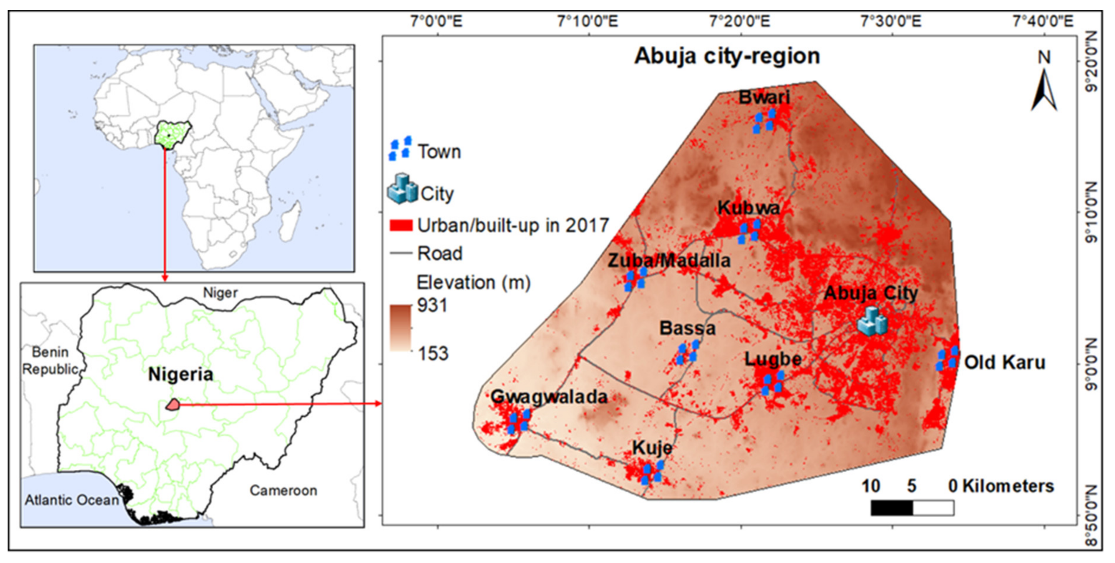
11]. For example, the past and current urban expansion patterns in the Abuja city-region, Nigeria are inconsistent with the land use plans as urban development expands into the land designated for non-urban development areas, including environmentally sensitive areas [9]. This leads to the degradation of environmentally sensitive areas of many African city-regions, including Abuja, highlighting the need to guide urban development effectively using strategic actions such as land use planning strategies [12,13,14]. Addressing the environmental sustainability problems caused by urban expansion patterns at the regional scale is useful in this regard, especially if used to guide local and urban planning processes [3,15,16,17]. This is, for example, recognized by the Nigerian Urban and Regional Planning Law of 1992 that made provision for the higher-order plans to provide a framework for the lower-order plans [16]. In Sub-Saharan Africa, including Nigeria, the land use planning process at the regional scale is, however, often neglected [16], which may lead to spatial inconsistencies (e.g., spatial conflicts) between urban and regional plans. Spatial conflict in this context can be regarded as a situation where a lower-order plan (e.g., an urban plan) deviates from the framework of a higher-order plan (e.g., a regional plan), which may result in e.g., urban development in those areas designated for non-urban development by the regional plan. This situation may contribute to the conflicts between urban developments and other land uses (e.g., intensive agriculture, productive forestry) proposed by the regional plan. The spatial inconsistencies between urban and regional plans, as well as the actual urban developments, hinder achieving the environmental goals of land use planning strategies [9,18].
To improve achieving the environmental goals of land use planning strategies, environmental assessments can be conducted using the Strategic Environmental Assessment (SEA) or para-SEA [19,20,21,22,23,24]. The SEA is an environmental planning and management instrument used for determining and mitigating the potential environmental impacts of policies, plans, and programs at both regional and urban/local scales [24,25,26,27,28]. The para-SEA is an informal process of conducting the environmental assessment of strategic actions, whereby the administrative framework is not defined or considered and the process does not meet the formal specifications of SEA but has some of their characteristics [24]. The SEA process aims to protect environments from strategic actions and promote environmental sustainability [19,29,30,31,32,33]. Applied SEA varies widely, but the general process includes screening, consideration of alternatives, description of the action, impact identification and scoping, prediction of impact magnitude and significance, identification of mitigation measures, preparing the documentation of the assessment, review, consultation, and public participation, decision-making, and monitoring implementation [33]. According to Therivel [32], the core of the SEA process includes environmental impact prediction, evaluation, and mitigation. The environmental impact prediction is to determine the scale, duration, and likelihood of the impacts, while evaluation is to determine whether the predicted impacts are significant or not, and mitigation is to reduce or eliminate the significant impacts [32]. Unlike the classical Environmental Impact Assessment (EIA) process, which focuses on predicting, evaluating, and mitigating the environmental impacts of project actions [26,31,34], the SEA process is used for predicting, evaluating, and mitigating the higher-level environmental impacts of strategic actions, including land use planning [26,31,34,35]. Implementing the SEA process has long-term benefits (e.g., environmentally-friendly development, a smoother planning process, greater plan transparency) that can vastly exceed the short-term cost, especially if it addresses environmental problems to support achieving the environmental goals of plans [36]. In some parts of the world, particularly in the European Union, the SEA process has been implemented since 2001 [37]. While implementing the SEA process in Sub-Saharan Africa, attempts were made in some countries, including Botswana [27], South Africa [38], and Ghana [39]. However, in most countries of Sub-Saharan Africa, including Nigeria, the formal SEA process has not been implemented in all sectors [40], including land use planning.
Theoretically, the relationship between land use planning and environmental assessments can be depicted using the socio-ecological idealism of spatial planning theory [41] and the SEA framework for strategic decision-making [32]. Socio-ecological idealism, which is a vision to reintegrate social and environmental problems into the planning process, has been used to broadly address the relationships among the human, built, and natural environments [41]. In recent years, socio-ecological idealism in planning was partially drawn under the sustainability umbrella, where the economic aspect of spatial planning was integrated into the theory, thus planning at e.g., urban and regional scales adopt the principles of neighborhood, community, urban, and regional sustainability [3,41,42]. Environmental assessment, which focuses majorly on the environmental aspect of sustainability, also considers both social and economic aspects [19] and may foster the actualization of the socio-ecological idealism vision in land use planning. Socio-ecological idealism indicates to environmental assessment the holistic value and socio-environmental visions for the desired future in the evaluation of options in strategic planning [41]. Therefore, environmental assessment and land use planning can be used to improve urban and regional environmental sustainability [1,3,4,5,6,19,29,30,31,32,33]. While land use planning focuses on the spatial arrangement of land use, environmental assessment can be used to: reduce the environmental risk of the plan; streamline the project action of the plan; faster plan approval; and better plan implementation [36] that reflects socio-ecological idealism in land use planning. The SEA framework for strategic decision-making, including land use planning strategy is used to describe: environmental baseline and identify alternatives land use plans; prepare scoping reports, predict and evaluate impacts of the alternative land use plans; mitigate the impacts of the chosen alternative land use plan; prepare the SEA report for formal decision, and; monitor the implementation of the chosen alternative land use plan [32].
Land use planning strategies and environmental assessments are faced with various challenges in the Global South, including Sub-Saharan Africa [27,43,44,45]. Lack of financial capacities challenges land use planning in Lagos, Nigeria, and the Takoradi and Bolgatanga regions of Ghana [43,45]. Political interference is a key challenge facing land use planning in Kampala in Uganda and Kigali in Rwanda [46]. Additionally, customary land tenure, lack of law enforcement, and distrust in government are barriers to effective land use planning in Ghana [45]. In Malawi’s main urban centers, lack of human and technological capacity, corruption, and outdated legal and policy frameworks pose significant challenges to land use planning [44]. Regarding environmental assessment at the sub-regional level, a lack of legislation, inadequate awareness, and low technical standards have been shown to burden and render the SEA process in Botswana suboptimal [27]. Retief et al. [38] demonstrate that a lack of focus, lack of integration with decision-making processes, and lack of assessment furthermore hinder the SEA practice in South Africa. According to Ofori [39], lack of legal or institutional frameworks, developing alternative strategic actions, lack of organized baseline data are amongst challenges facing the SEA process in Ghana. Outside the Sub-Saharan Africa region, Slunge and Tran [47] posit that inadequate training, financial resources are key challenges to institutionalizing SEA in Vietnam. Addressing these key challenges may be helpful to improve the environmental sustainability of city-regions, but may not be the answer to all problems, considering the fast rate of urbanization [48,49,50,51] that planning cannot keep up with and the challenges to control such urbanization by local, regional, and national governments. However, the development of the Abuja city-region from scratch using land use planning strategies [52] makes it the best-case study for investigating land use planning and environmental assessment challenges, considering the long-term benefits of the SEA process that can vastly exceed the short-term cost [36].
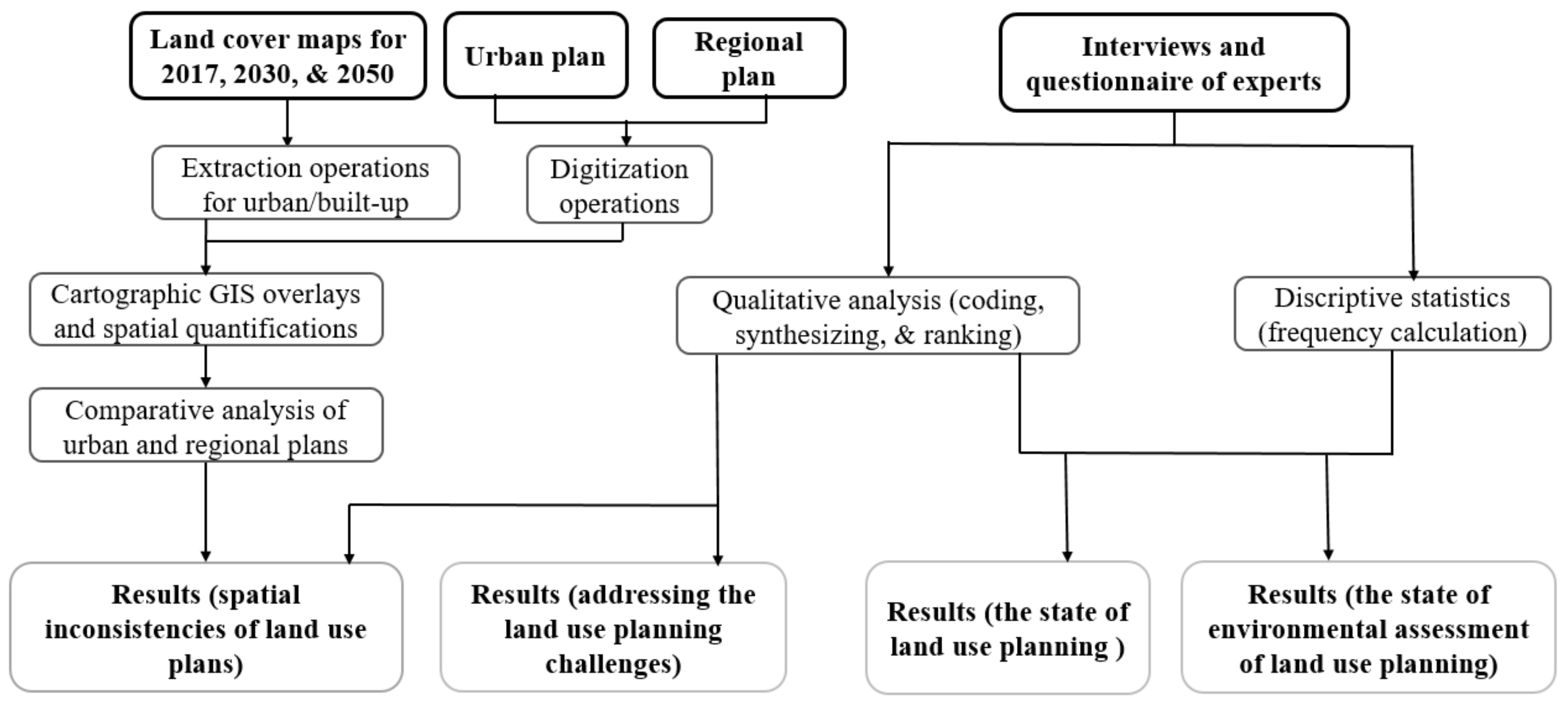
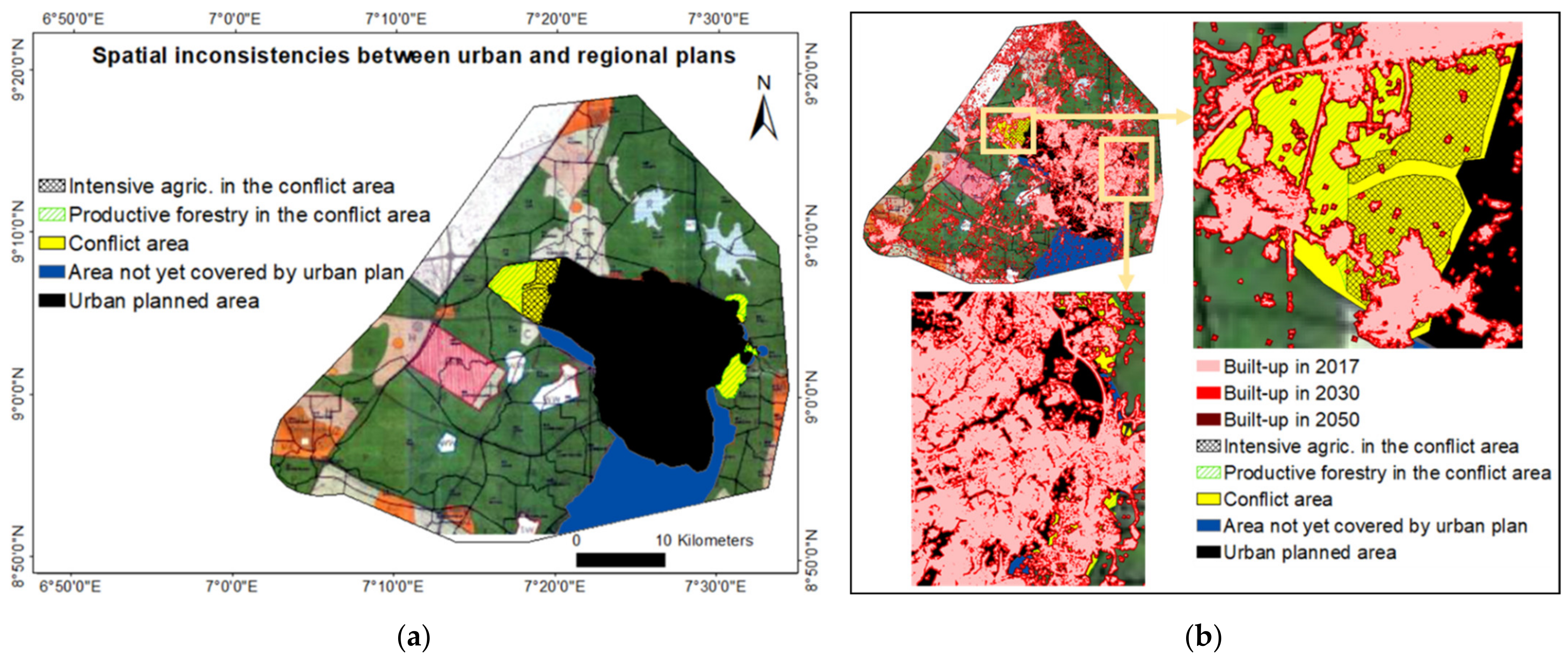
We aim to combine Geographic Information Systems (GIS)/Remote Sensing (RS) and survey-based data to investigate the key challenges of land use planning and its environmental assessments for the purpose of improving the urban and environmental sustainability of city-regions. Specifically, we investigate (1) the spatial inconsistencies and the causes between urban and regional plans, as well as the associated conflicts between the built-up areas and other land uses; (2) the state of land use planning; (3) the state of environmental assessments of land use planning, and; (4) the ways to address these challenges for effective land use planning. Our findings help to identify key challenges of land use planning, including spatial inconsistencies between urban and regional plans, as well as the associated conflicts between the current/future urban growth and land use proposed for intensive agriculture and productive forestry. Also, we identified the causes of the spatial inconsistencies between urban and regional plans, including conflicts in administrative boundaries, conflicts in funding the land use planning process, and lack of good coordination. Additionally, our study shows that implementing the SEA process of land use planning in such a way to avert the challenges (e.g., overlapping functions between the government ministries and agencies) facing the current EIA process would improve achieving the environmental goals of land use planning. Therefore, this paper contributes to land use planning as a strategic instrument for guiding and controlling urban expansion patterns and improving the urban and environmental sustainability of city-regions.

2. Materials and Methods

2.1. Study Area

The Abuja city-region (Figure 1) provides a suitable case study due to the insufficiency of existing land use planning instrumentation at urban and regional scales for guiding and controlling its rapid urban expansion patterns throughout the past three decades and the negative implications of this on current and future environmentally sensitive areas [9,12]. The Federal Capital Territory (FCT) that comprises 6 local government areas, including the defined city-region of this study, was created in 1976 to develop a new federal capital with sustainable development and to avert challenges (e.g., environmental and social problems) that hindered the sustainable development of the formal capital, Lagos [11,50,53,54,55]. To avert such problems in the FCT region, regional and urban land use plans were developed in 1979 to guide urban and regional development before the relocation of the government seat from Lagos to Abuja in 1991 [50,52,56]. The plans were made for 25 years of developments with provisions for constant reviews to guide developments beyond the 25 years [50]. The regional plan has not been reviewed officially but was reproduced in 2000 [12]. While addressing the problems of unguided urban development using land use planning, the Federal Capital Development Authority (FCDA) of Abuja implemented mass evictions in the inner city, accompanied by strict demolition of informal settlements between 2003 and 2007 [57,58,59]. Addressing the key challenges of housing is particularly urgent given that this is one of Sub-Saharan Africa’s fastest-growing city-regions with an average annual population growth rate of about 5.3% [48]. The population was estimated to be 1.4 million in 2006 [52], growing to 2.3 million in 2015 [48]. Additionally, the population was estimated to be 3.8 million in 2017 using a 9.1% growth rate defined by the National Population Commission [9]. As a rapidly growing city-region, its urban and regional economy is booming correspondingly, with an estimated GDP per capita of $5612 in 2015 [60]. This has in turn severely impacted areas set aside for intensive agriculture, animal husbandry, and the ecologically protected areas [9].

2.2. Data Collection

We combined data from different sources, including GIS/RS and surveys of experts. While the GIS/RS data included land cover maps and land use plans, the survey-based data were derived using questionnaires and interviews.

2.2.1. Land Cover Maps and Land Use Plans

Land cover maps for 2017, 2030, and 2050 were collected from our previous studies of the Abuja city-region [9,12]. The 2017 land cover map was derived from LANDSAT 8 satellite images captured in 2017 using supervised classification and maximum likelihood algorithm [61,62,63]. The 2030 and 2050 land cover maps were produced by simulation using the Multi-Layer Perceptron (MLP) neural network and Markov models of urban growth [12,64,65]. The land cover model was calibrated using the 2002 and 2017 land cover maps, as well as some selected maps on spatial determinants of urban expansion as driver variables. The driver variables included topographic elevation and distance to protected areas as static variables, distances to road networks, and built-up areas for 2002 and 2017 as dynamic variables derived through Euclidean distance modeling [12]. The model was validated at 90.3% overall accuracy using the predicted and actual land cover maps for 2019. The final simulation was based on extrapolating the past trends of land cover change, with a scenario assumption that features future urban spatial patterns without additional determinants of urban growth [12]. The reason for collecting this particular predicted land use map was to evaluate the future implementation of land use plans, following the strengths and weaknesses of the past and current implementation. Also, to identify future challenges that may confront the implementation, especially if the weaknesses are not addressed.
We also collected the regional land use plan from the Abuja Geographic Information Systems (AGIS) [66] and the urban land use plan from the Department of Urban and Regional Planning (DURP) of FCDA, Abuja [67,68]. The urban and regional land use plans were developed by International Planning Associates (IPA) in 1979 to preserve the natural environment, develop a functional and garden city, improve the accessibility of all areas, effective regional development, rapid national economic growth [50,69].

2.2.2. Interviews and Questionnaires

The first author conducted semi-structured interviews and administered questionnaires from 4 July to 5 August 2019. The English-language interviews and questionnaires were designed to elicit expert knowledge and opinion from urban and regional planning and environmental assessment professionals in the study area. The question structure and content of both interviews and questionnaires were based on a prior literature review on land use planning challenges and environmental assessment alongside the findings of the previous study from Enoguanbhor et al. [9] and comprised of both closed-ended and open-ended questions. Participants were recruited to respond to our questions using snowball non-probability sampling [70,71,72], beginning with the selected contacts of Directors in various departments/agencies. For urban and regional planning experts, we distributed and retrieved 25 questionnaires at the target government departments/agencies, including the DURP of FCDA (n = 10), the Department of Urban and Regional Development of the Federal Ministry of Housing, Abuja (n = 7). Others included the Abuja branch of the Nigerian Institute of Town Planners (NITP; n = 4) and the Department of Development Control (DDC) of FCDA Abuja (n = 4). The work experience of the urban and regional planning experts ranges from 0–10 years (20%), 11–20 years (52%), 21–30 years (12%), and 31 years and above (16%). The highest academic level completed by the experts constitutes Bachelor or equivalent (16%), Masters or equivalent (68%), and PhD or equivalent (16%). Additionally, 10 environmental assessment experts from various government and private offices were recruited for interviews, as listed in Table 1. The interview lasted approximately 40 minutes, was conducted in English, and was transcribed in full.

2.3. Data Analysis

We quantified the spatial inconsistencies between urban and regional plans using the cartographic GIS overlays [9]. First, we digitized and calculated the conflict areas that are defined as those areas designated for non-urban development by the regional plan but are designated for urban development by the urban plan. Second, we digitized and calculated land uses designated e.g., for productive forestry and intensive agriculture within the conflict areas. Third, we digitized and calculated the areas designated for urban development by regional plan but not yet defined for urban development by the urban plan. Finally, we overlaid and calculated the built-up area in all the digitized areas (e.g., conflict areas) for 2017, 2030, and 2050.
Descriptive statistics were summarized for the expert questionnaire results, using response frequencies to assist in identifying variables on challenges facing land use planning. Additionally, we analyzed the open questions and interviews qualitatively using the process of coding and synthesizing [73,74,75]. We sorted and synthesized the coded variables and ranked them as inscribed in Table 2. Figure 2 summarizes the data types and analysis methods.

3. Results

3.1. Spatial Inconsistencies and the Causes between Urban and Regional Plans

Our results (Table 3 and Figure 3) indicated the spatial inconsistencies between urban and regional plans and the associated built-up area. While the total conflict area (50.38 km2) between urban and regional plan is associated with a 15.67 km2 built-up area in 2017, it may be associated with 22.72 km2 and 27.43 km2 built-up areas for 2030 and 2050 respectively. Within the conflict area, the land use designated for productive forestry (27.31 km2) is associated with a 10.99 km2 built-up area in 2017, in which the association may increase to 16.22 km2 and 19.34 km2 for 2030 and 2050 respectively. Another land use type identified within the conflict area is the land use defined for intensive agriculture, covering a total area of 15.39 km2, in which 2.73 km2 is lost to built-up in 2017. The result shows that in 2030 and 2050, the loss of such land use to built-up areas may increase to 3.65 km2 and 4.49 km2 respectively within the conflict areas. The result shows that the total area (125.32 km2) of land proposed for urban development by the regional plan but not yet defined or implemented by the urban plan is associated with a 10.16 km2 built-up area in 2017 and the associated built-up area may increase to 17.95 km2 and 27.16 km2 in 2030 and 2050 respectively.
The qualitative results indicated that experts held the spatial inconsistencies between urban and regional plans to be a key challenge in land use planning caused by lack of coordination, conflicts in administrative boundaries, and conflicts in funding the land use planning process, and political interference (Table 4). Our results showed that the less priority to regional planning in Abuja is attributed to lack of political will and interest in regional land use, insufficient funding of the regional plan implementation, lack of regional integration concept in planning, conflicting planning authorities (e.g., FCDA and area councils), and non-town planners in political positions (Table 4).

3.2. The State of Land Use Planning

Our results (Table 5) indicated failures of land use planning in the Abuja city-region, including the inconsistencies between the plans and actual development, resettlement and integration, poor planning projection, and the emergence of informal settlements. However, our results (Table 5) also captured achievements, including a well-designed urban development plan of the capital city, provision of basic infrastructures, and mass housing developments.
We investigated the contributing factors to haphazard urban expansion in peri-urban/satellite settlements and our results showed that the inadequate implementation of land use plans (48%), the limited spatial scope of the urban plan to the regional plan (36%), and others (16%) contribute to the problems. Our results (Table 6) indicated the inadequate implementation of land use plans is mostly attributed to insufficient funding, lack of political will, inadequate manpower, and interference (e.g., local governments, local people, developers).

3.3. The State of the Environmental Assessment of Land Use Planning

In our results on the environmental assessment of land use planning, 76% of the experts agreed that the assessments are being implemented, while 24% disagreed. Among the experts that agreed to the implementation of environmental assessments of land use plans, 80% indicated that the instrument being used is the EIA, while 20% have no ideas on the instruments. Our results indicated that the reasons why the formal SEA process has not been implemented in Nigeria are mostly due to weak political will, ignorance of the policy-makers, and inadequate technical capacity/professionalism problem (Table 7). However, the results suggested that the formal SEA process should be implemented in Nigeria.
Our results showed that the challenges facing the impact prediction and evaluation process in the environmental assessment of land use planning are mostly attributed to inadequate manpower/dearth of professionals. Others include insufficient data availability, lack of relevant tools for analysis, inadequate funding, and corruption in the system (Table 8). Regarding the challenges facing the mitigation process in the environmental assessment of land use planning, our study identified no strong environmental agencies, lack of monitoring by the agencies, lack of good predictions, overlapping functions between the government ministries and agencies, lack of understanding of the process, and corruption during implementation (Table 8).

3.4. Ways to Address Challenges for Effective Land Use Planning

While addressing the challenges facing land use planning, our results (Table 9) highlighted the suggestions from experts, including making the regional planning and development a priority, no compromise on political will, consistency between a well-developed plan, and implementation. Other suggestions include complete relocation and compensation of local inhabitants suggested by policy and plans, involving all relevant agencies during plan implementation for effective development control, seeking sustainable sources of funding, and the use of competent experts/professionals.

4. Discussion

This study provides the first comprehensive investigation on land use planning and the environmental assessment challenges in relation to urban land dynamics in the Abuja city-region, Nigeria. We combined data derived from GIS/RS and surveys of experts to investigate such challenges for the purpose of improving the urban and environmental sustainability of city-regions.

4.1. Findings

Our findings from GIS/RS analysis indicate the spatial inconsistencies between urban and regional land use plans and the associated built-up areas, as well as the loss of land use designated for productive forestry and intensive agriculture in the conflict areas (Table 3 and Figure 3). The loss of land use designated for productive forestry and intensive agriculture in the conflict areas, which are attributed to unguided urban expansion patterns due to spatial inconsistencies of the plans may increase as future urban land continues to expand into the conflict areas. Experts held the spatial inconsistencies between urban and regional plans to be a key challenge in land use planning caused by lack of coordination, conflicts in administrative boundaries, conflicts in funding the land use planning process, and political interference (Table 4). These findings are similar to that of Goodfellow [46] who claims that political interference is a major challenge to urban development, particularly on the implementation process of urban planning in Kampala, Uganda, and Kigali, Rwanda. The problems of spatial inconsistencies between urban and regional land use plans are also associated with less priority given to regional development planning, to the point that it is often nearly neglected in urban planning regimes, as reported by Wahab, Egunjobi, and Falola, [16]. Our finding showed that the less priority to regional planning in Abuja is attributed to lack of political will and interest in regional land use, insufficient funding of the regional plan implementation, lack of regional integration concept in planning, conflicting planning authorities (e.g., FCDA and area councils), and non-town planners in political positions (Table 4).
Regarding the investigation on the state of land use planning, our findings indicate failures of land use planning in the Abuja city-region, including the inconsistencies between the plans and actual development, resettlement and integration, poor planning projection, the emergence of informal settlements (Table 5). Some findings e.g., inconsistencies between the land use plans and actual urban development and poor planning projection confirm other findings from Enoguanbhor et al. [9]; Enoguanbhor et al. [12]. However, the findings also capture achievements, including a well-designed urban development plan of the capital city, provision of basic infrastructures, and mass housing developments. The investigation on contributing factors to haphazard urban expansion in peri-urban/satellite settlements shows that the inadequate implementation of land use plans and the limited spatial scope of the urban plan to the regional plan contribute to the problems. The findings indicate the inadequate implementation of land use plans is attributed to insufficient funding, lack of political will, inadequate manpower, interference (e.g., local governments, local people, developers), inadequate development control, and corruption (Table 6). Our findings on corruption and inadequate manpower are similar to that of Mwathunga and Donaldson [44] who reported the lack of human and technological capacity, corruption, as challenges facing land use planning in Malawi’s main urban centers. Our findings on insufficient funding coincide with those of Dano et al. [43]; Kleemann et al. [45] who reported similar cases of land use planning challenges for Lagos, Nigeria, and the Takoradi and Bolgatanga regions of Ghana.
The investigation on the state of the environmental assessment of land use planning shows that the assessments are being implemented but with the use of EIA instruments, which has a limited scope to address the higher-level environmental assessment of land use planning as a strategic action [31,34]. The SEA or Para-SEA instruments for land use planning have not been implemented and this supports the findings of Ogbonna and Albrecht [40] who reported the lack of SEA implementation in Nigeria. Our study identifies the reasons why the formal SEA process has not been implemented in Nigeria, including weak political will, ignorance of the policy-makers, and inadequate technical capacity/professionalism problem (Table 7). However, our finding suggests that the formal SEA process should be implemented in Nigeria. Reasons given by interviewees for this included improving environmental sustainability, creating synergy among relevant stakeholders, making the EIA process achievable, addressing socio-cultural conflicts from policy, planning, and program implementation within the multi-ethnic nation. The opinion of the experts to implement the formal SEA process supports the findings of Therivel and González [36], who show that the benefits of implementing SEA can vastly exceed the costs especially if it leads to environmentally-friendly development of the plans. Our findings show that the challenges facing the impact prediction and evaluation process in the environmental assessment of land use planning, and thus also any potential SEA-process, include insufficient data availability, lack of relevant tools for analysis, inadequate manpower/dearth of professionals, inadequate funding, and corruption in the system (Table 8). Our finding on insufficient data availability is similar to that of Xia et al. [76]; Ofori [39], who reported inadequate data as a challenge facing the environmental assessment process in China and Ghana respectively. Our finding on inadequate funding as a challenge to implementing the environmental assessment process has also been shown in Columbia and Vietnam [47,77]. Regarding the challenges facing the mitigation process in the environmental assessment of land use planning, our study identifies no strong environmental agencies, lack of monitoring by the agencies, lack of good predictions, overlapping functions between the government ministries and agencies, lack of understanding of the process, and corruption during implementation (Table 8).
Addressing the challenges facing land use planning, our study highlighted the suggestions, including making the regional planning and development a priority, no compromise on political will, consistency between a well-developed plan and implementation (Table 9). Other suggestions include complete relocation and compensation of local inhabitants suggested by policy and plans, involving all relevant agencies during plan implementation for effective development control, seeking sustainable sources of funding, the use of competent experts/professionals, comprehensive analysis of socio-economic components of the city, and incorporating cultural heritage protection into the master plan. This would help in improving the urban sustainability of the city-region.

4.2. Implications of the Findings

An important implication of our findings addresses the spatial inconsistencies between urban and regional plans as a key challenge facing land use planning. This underscores the necessity to address the causes of such inconsistencies (e.g., lack of coordination, conflicts in administrative boundaries, conflicts in funding the land use planning process, political interference) to review the existing land use plans for sustainable development. Such inconsistencies (e.g., the spatial conflicts) might have contributed to spatial urban expansion on land designated for non-urban development, particularly, productive forestry and intensive agriculture (Figure 3 and Table 3), posing challenges to improve environmental sustainability. This inconsistency is exemplified by the urban plan phase I extension and phase IV-A designed to provide urban functions, including residential, industrial, town park, neighborhood and district centers, and educational areas within the land use initially designated for productive forestry and intensive agriculture by the regional plan [66,67,68]. The loss of land use designated for productive forestry and intensive agriculture by urban development may be associated with the loss of ecosystem services (e.g., food, fuel, and fiber) provided by such land use [9,78,79,80,81]. However, while the urban plan phase I extension has been implemented, the phase IV-A has not been implemented, implying that the urban functions (e.g., industrial, town park, neighborhood, and district centers) have not been achieved in those conflict areas, leaving the areas with haphazard urban expansion patterns. The spatial inconsistency of the land designated for urban development by the regional plan but not yet defined or implemented by the urban plan for urban development might have contributed to haphazard urban expansion patterns in those areas, posing challenges towards creating a functional urban environment. Additionally, the inadequate implementation of land use plans in peri-urban/satellite settlements contributed to haphazard urban expansion patterns in those areas. This is the case for Gwagwalada, Kuje, Zuba, Kubwa, Bwari informal settlements that feature haphazard urban development [9].
Another implication of our findings is the failure of the land use planning process to address, e.g., the emergence of informal settlements, which are settlements made up of the majority of urban growth in Sub-Saharan Africa [49,82,83,84,85] and are featured by housing deterioration and the zone for low-income earners [86]. Such settlements are notoriously hard to plan and restructure. The urban spatial patterns in informal settlements are associated with poor sanitary environments that affect the health of urban dwellers [12]. The inadequate implementation of land use plans, which is attributed to insufficient funding, lack of political will, inadequate manpower, interference, and corruption, implies that the land use planning process alone cannot address the haphazard urban expansion problems in peri-urban/satellite settlements if the attributed causes are not addressed.
An additional implication of our findings is the non-applicability of the formal SEA or para-SEA process in land use planning, indicating inadequate environmental and social impact assessments of land use plans that may contribute to haphazard urban expansion patterns and the environmental impacts. For example, the cumulative environmental impacts of road networks and institutions of higher learning as elements of urban planning and development may not be assessed effectively at the urban and regional scales without the SEA process. The implication of adopting the EIA instrument to predict the environmental impacts of land use planning can also be associated with inadequate impact assessments due to the limited scope of EIA to assess the higher-level environmental impacts of land use planning. The situation is similar to the majority of cases in Peru SEA with project-level impact assessments [87]. The non-applicability of the formal SEA/para-SEA or the applicability of the EIA may hinder achieving the cultural, social, economic, and environmental goals of land use planning. The SEA can be used to identify or streamline cultural heritage impacts of land use plans [88], especially in situations where cultural heritage protection is yet to be incorporated into land use plans. In the case of Abuja, experts of land use planning suggested that cultural heritage protection should be incorporated into land use planning (see Table 9), implying either cultural heritage issues have not been incorporated or have not been addressed effectively using land use planning. Therefore, the SEA of land use planning may improve the cultural, social, economic, and environmental goals of the plans. However, the process may not bring a total solution to haphazard urban expansion in peri-urban/satellite settlements, especially if similar challenges associated with the current EIA process (e.g., overlapping functions between the government ministries and agencies, corruption during implementation, inadequate funding) are not addressed.
The socio-ecological idealism implication of our findings can be deduced from a lack of regional integration concept in regional land use planning (Table 4) and lack of SEA or para-SEA of land use planning. The lack of regional integration concept implies that the technical aspect of the integration, which consists of social, economic, and physical planning [89] may not be handled effectively to reflect the socio-ecological idealism in regional land use planning. Additionally, the lack of SEA or para-SEA of land use planning implies that the gap between socio-economic and environmental integration of the regional land use planning may not be identified and/or closed effectively to foster actualizing the socio-ecological idealism vision in regional land use planning. However, the awareness of the need to implement the SEA process among the experts (Table 7) implies that the integration gaps in socio-ecological idealism may be identified and/or closed, especially if the SEA process is implemented effectively by resolving its potential challenges.

4.3. Limitations

One limitation of the present study is the unavailability of the urban plans for peri-urban/satellite settlements. The available land use plans used for this study are the phases I, II, III, and IV-A of the Abuja city and the regional land use plan of the entire region. This situation did not allow the quantification of the spatial inconsistencies between urban and regional plans in Abuja city phase IV-B and peri-urban/satellite settlements, thus limited the quantification to Abuja city Phases I-IV-A. Another limitation can be linked to the intentional/unintentional response bias in the survey data that could not be detected in our study. An additional limitation is our inability to go into detailed land use planning and environmental assessment processes, as well as the actors, including the public participation due to the thematic scope of the study focusing on key challenges of land use planning and environmental assessments from a holistic point of view.

4.4. Recommendations

In addition to the recommendation from experts on addressing key challenges for effective land use planning, we recommend the following:
First, to avert the spatial inconsistencies between urban and regional plans, sufficient and updated data on land use/cover and population should be made available for urban and regional planners. Also, conflicts in administrative boundaries at the local government and county levels should be resolved. Additionally, there should be adequate coordination at various levels of planning (e.g., local, urban, regional) and among planning authorities (e.g., FCDA, local governments) during the land use planning process.
Second, regarding the inadequate implementation of land use planning as a contributing factor to haphazard urban expansion in peri-urban/satellite settlements, there should be available detailed urban plans for those regions and such plans should undergo constant reviews. Also, adequate development control should be implemented to avert land use violations. Additionally, proper prosecution of land use violations should be implemented under the legal and administrative frameworks/guidelines. Furthermore, the lack of regional integration concept in planning as one of the causes of less priority to regional planning should be addressed in all land use planning processes, including the implementation process.
Third, regarding the state of environmental assessments of land use planning, efforts should be made to implement the formal SEA process or develop the para-SEA process to conduct the effective environmental assessment of land use planning and improving environmental sustainability. This could be used to regulate the spatial arrangements of urban elements away from environmentally sensitive areas. While implementing the SEA/para-SEA process, the problems (e.g., overlapping functions between the government ministries and agencies, corruption during implementation, inadequate funding) associated with the impact prediction, evaluation, and mitigation of the current EIA process should be addressed in the SEA process of land use planning. Also, the social and cultural heritage assessments of land use planning should be given priority during the SEA process of land use planning to reduce or eliminate socio-cultural conflicts and protect the cultural heritage. Additionally, the general SEA process of land use planning may adopt that of the EU systems, especially when dealing with the potentially significant environmental issues due to the successful implementation of the process within the EU region [37]. However, specific areas e.g., cultural, social, and economic aspects of the SEA can be modified by considering the socio-cultural and economic conditions of the people being planned for. For example, the perceptions of Africans on what they value as cultural heritage may be different from that of the Europeans. Therefore, the peoples’ opinions should always be evaluated and incorporated into land use planning and SEA processes to improve urban and environmental sustainability for the people.
Finally, future research should incorporate urban plans of peri-urban/satellite settlements on spatial planning inconsistencies and the associated built-up areas of the entire city-region as well as the state of public participation in land use planning and environmental assessment processes.

5. Conclusions

We combined GIS/RS and survey-based data to investigate key challenges of land use planning and its environmental assessments for the purpose of improving the urban and environmental sustainability of city-regions.
Perhaps, most alarming are the multiple inconsistencies (e.g., spatial conflicts) between urban and regional plans and the associated built-up areas caused by a lack of good coordination, conflicts in administrative boundaries, insufficient data, and professionalism/incompetence. While investigating the state of land use planning, our study showed that land use planning failed to address the inconsistencies between the plan and actual development, poor resettlement and integration, poor planning projection, and the emergence of informal settlements. However, the achievements of land use planning are the well-designed urban development plan of the capital city, provision of basic infrastructures, and mass housing developments. The process of land use planning contributing to haphazard urban expansion in peri-urban/satellite settlements is attributed to the inadequate implementation of land use plans. The inadequate implementation of land use plans is caused by insufficient funding, lack of political will, inadequate manpower, interference (e.g., local governments, local people, developers), and corruption. While investigating the state of the environmental assessment of land use planning, our study showed that there is a lack of formal SEA process or/and para-SEA process caused by weak political will, ignorance of the policy-makers, and a lack of technical capacity/professionalism problems. However, the environmental assessments of land use planning as a strategic action are being implemented using the EIA instrument, which is primarily designed for assessing the environmental impacts of project actions. The impact prediction and evaluation as the core process in the current environmental assessment of land use planning are being challenged by inadequate manpower/dearth of professionals, inadequate relevant tools for analysis, insufficient data availability. The mitigation as an additional core process in the environmental assessment of land use planning is being challenged by not following the suggested mitigation measures, no strong environmental agencies/lack of monitoring by the agencies, and overlapping functions between the government ministries and agencies. Our findings on addressing the key challenges (e.g., consistency between a well-developed plan and implementation) for effective land use planning and integrating the SEA or Para-SEA process into the land use planning process would probably improve achieving the environmental goal of land use planning.
The baseline information provided in this study is crucial to improve strategic planning and urban/environmental sustainability of city-regions in Sub-Saharan Africa and across the Global South, where land use planning faces similar challenges to address the haphazard urban expansion patterns. Future research should incorporate the urban plans of peri-urban/satellite settlements to quantify the spatial inconsistencies between urban and regional plans, and the associated built-up areas of the entire city-region and investigate the state of public participation in the processes of land use planning and environmental assessment.

Author Contributions

Conceptualization, E.C.E.; methodology, E.C.E.; formal analysis, E.C.E.; investigation, E.C.E.; data curation, E.C.E.; writing—original draft preparation, E.C.E.; writing—review and editing, T.L., J.O.N., B.B.W., and F.G.; visualization, E.C.E.; supervision, T.L., J.O.N., B.B.W., and F.G. All authors have read and agreed to the published version of the manuscript.

Funding

This research received no external funding.

Institutional Review Board Statement

Not applicable.

Informed Consent Statement

Informed consent was obtained from all subjects involved in the study.

Data Availability Statement

The spatial data presented in this study are available at doi:10.3390/su11051313 (accessed on 18 April 2021) and doi:10.1007/s10708-020-10317-x (accessed on 18 April 2021).

Acknowledgments

We acknowledge support by the German Research Foundation (DFG) and the Open Access Publication Fund of Humboldt-Universität zu Berlin. The authors are grateful to Paul+Maria Kremer Stiftung for the PhD scholarship awarded to the first author. Also, the authors are grateful to Abuja Geographic Information Systems (AGIS) and the Department of Urban and Regional Planning (DURP) of the Federal Capital Development Authority (FCDA) Abuja for making the regional and urban land use plans available for the study.

Conflicts of Interest

The authors declare no conflict of interest.

References

  1. Liang, Y.; Du, M.; Wang, X.; Xu, X. Planning for urban life: A new approach of sustainable land use plan based on transit-oriented development. Eval. Program Plan. 2020, 80, 101811. [Google Scholar] [CrossRef]
  2. Phillips, P.M.; João, E. Land use planning and the ecosystem approach: An evaluation of case study planning frameworks against the Malawi Principles. Land Use Policy 2017, 68, 460–480. [Google Scholar] [CrossRef] [Green Version]
  3. Mohamed, A.; Worku, H.; Lika, T. Urban and regional planning approaches for sustainable governance: The case of Addis Ababa and the surrounding area changing landscape. City Environ. Interact. 2020, 100050. [Google Scholar] [CrossRef]
  4. Cobbinah, P.B.; Asibey, M.O.; Gyedu-Pensang, Y.A. Urban land use planning in Ghana: Navigating complex coalescence of land ownership and administration. Land Use Policy 2020, 99, 105054. [Google Scholar] [CrossRef]
  5. Li, F.; Li, Z.; Chen, H.; Chen, Z.; Li, M. An agent-based learning-embedded model (ABM-learning) for urban land use planning: A case study of residential land growth simulation in Shenzhen, China. Land Use Policy 2020, 95, 104620. [Google Scholar] [CrossRef]
  6. Belčáková, I. Strategic Environmental Assessment–An Instrument for Better Decision-Making Towards Urban Sustainable Planning. Procedia Eng. 2016, 161, 2058–2061. [Google Scholar] [CrossRef] [Green Version]
  7. Morelli, J. Environmental Sustainability: A Definition for Environmental Professionals. J. Environ. Sustain. 2011, 1, 19–27. [Google Scholar] [CrossRef] [Green Version]
  8. BMZ (Federal Ministry for Economic Cooperation and Development). Land Use Planning: Concept, Tools and Applications; GIZ (German Corporation for International Cooperation): Eschborn, Germany, 2012. [Google Scholar]
  9. Enoguanbhor, E.C.; Gollnow, F.; Nielsen, J.O.; Lakes, T.; Walker, B.B. Land Cover Change in the Abuja City-Region, Nigeria: Integrating GIS and Remotely Sensed Data to Support Land Use Planning. Sustainability 2019, 11, 1313. [Google Scholar] [CrossRef] [Green Version]
  10. Mahmoud, M.I.; Duker, A.; Conra, C.; Thiel, M.; Ahma, H.S. Analysis of Settlement Expansion and Urban Growth Modelling Using Geoinformation for Assessing Potential Impacts of Urbanization on Climate in Abuja City, Nigeria. Remote Sens. 2016, 8, 220. [Google Scholar] [CrossRef] [Green Version]
  11. Ade, M.A.; Afolabi, Y.D. Monitoring urban sprawl in the Federal Capital Territory of Nigeria using Remote Sensing and GIS techniques. Ethiop. J. Environ. Stud. Manag. 2013, 6, 82–95. [Google Scholar] [CrossRef] [Green Version]
  12. Enoguanbhor, E.C.; Gollnow, F.; Walker, B.B.; Nielsen, J.O.; Lakes, T. Simulating Urban Land Expansion in the Context of Land Use Planning in the Abuja City-Region, Nigeria. GeoJournal 2020. [Google Scholar] [CrossRef]
  13. Mohamed, A.; Worku, H. Simulating urban land use and cover dynamics using cellular automata and Markov chain approach in Addis Ababa and the surrounding. Urban. Clim. 2020, 31, 100545. [Google Scholar] [CrossRef]
  14. Xu, G.; Dong, T.; Cobbinah, P.B.; Jiao, L.; Sumari, N.S.; Chai, B.; Liu, Y. Urban expansion and form changes across African cities with a global outlook: Spatiotemporal analysis of urban land densities. J. Clean. Prod. 2019, 224, 802–810. [Google Scholar] [CrossRef]
  15. Guo, Z.; Hu, Y.; Zheng, X. Evaluating the effectiveness of land use master plans in built-up land management: A case study of the Jinan Municipality, eastern China. Land Use Policy 2019. [Google Scholar] [CrossRef]
  16. Wahab, B.; Egunjobi, L.; Falola, O. Regional Planning and Development in Nigeria: An Overview. In Regional Planning and Development in Nigeria; Wahab, B., Egunjobi, L., Gyuse, T., Kadiri, W., Eds.; Nigerian Institute of Town Planners (NITP) & Town Planners Registration Council of Nigeria (TOPREC), FCT Abuja: Abuja, Nigeria, 2014; pp. 1–21. [Google Scholar]
  17. Wang, L.-G.; Han, H.; Lai, S.-K. Do plans contain urban sprawl? A comparison of Beijing and Taipei. Habitat Int. 2014, 42, 121–130. [Google Scholar] [CrossRef]
  18. Liu, T.; Huang, D.; Tan, X.; Kong, F. Planning consistency and implementation in urbanizing China: Comparing urban and land use plans in suburban Beijing. Land Use Policy 2020, 94, 104498. [Google Scholar] [CrossRef]
  19. Campo, A.G.D.; Gazzola, P.; Onyango, V. The mutualism of strategic environmental assessment and sustainable development goals. Environ. Impact Assess. Rev. 2020, 82, 106383. [Google Scholar] [CrossRef]
  20. Siqueira-Gay, J.; Sánchez, L.E. Mainstreaming environmental issues into housing plans: The approach of Strategic Environmental Assessment. Environ. Impact Assess. Rev. 2019, 77, 145–153. [Google Scholar] [CrossRef]
  21. Unalan, D.; Cowell, R. Strategy, context and strategic environmental assessment. Environ. Impact Assess. Rev. 2019, 79, 106305. [Google Scholar] [CrossRef]
  22. Rega, C.; Singer, J.P.; Geneletti, D. Investigating the substantive effectiveness of Strategic Environmental Assessment of urban planning: Evidence from Italy and Spain. Environ. Impact Assess. Rev. 2018, 73, 60–69. [Google Scholar] [CrossRef]
  23. Rojas, C.; Pino, J.; Jaque, E. Strategic Environmental Assessment in Latin America: A methodological proposal for urban planning in the Metropolitan Area of Concepción (Chile). Land Use Policy 2013, 30, 519–527. [Google Scholar] [CrossRef]
  24. Dalal-Clayton, B.; Sadler, B. Strategic Environmental Assessment, 1st ed.; Earthscan: London, UK, 2005. [Google Scholar]
  25. Josimovic, B.; Cvjetic, A.; Furundzic, D. Strategic Environmental Assessment and the precautionary principle in the spatial planning of wind farms–European experience in Serbia. Renew. Sustain. Energy Rev. 2021, 136, 110459. [Google Scholar] [CrossRef]
  26. Wu, Y.-Y.; Ma, H.-W. Challenges for Integrating Strategic Environmental Assessment to Enhance Environmental Thinking: A Case Study of Taiwan Energy Policy. Sustainability 2019, 11, 609. [Google Scholar] [CrossRef] [Green Version]
  27. Makaba, L.P.; Munyati, C. Strategic Environmental Assessment implementation and effectiveness bottlenecks: Lessons from Botswana. Environ. Dev. 2018, 26, 86–99. [Google Scholar] [CrossRef]
  28. Torrieri, F.; Batà, A. Spatial Multi-Criteria Decision Support System and Strategic Environmental Assessment: A Case Study. Buildings 2017, 7, 96. [Google Scholar] [CrossRef] [Green Version]
  29. Sebestyén, S.; Bulla, M.; Rédey, Á.; Abonyi, J. Network model-based analysis of the goals, targets and indicators of sustainable development for strategic environmental assessment. J. Environ. Manag. 2019, 238, 126–135. [Google Scholar] [CrossRef] [PubMed]
  30. Iyer, V.G. Strategic Environmental Assessment (SEA) Process for Sustainable Mining and Mineral Management Development. Open Access Libr. J. 2017, 4, e3422. [Google Scholar] [CrossRef]
  31. OECD (Organisation for Economic Co-operation and Development). Applying Strategic Environmental Assessment: Good Practice Guidance for Development Co-operation; OECD: Paris, France, 2006. [Google Scholar]
  32. Therivel, R. Strategic Environmental Assessment in Action; Earthscan: London, UK, 2004. [Google Scholar]
  33. Lee, N.; George, C. Environmental Assessment, Developing Countries and Countries in Transitions, 1st ed.; John Wiley & Sons Ltd.: West Sussex, UK, 2000. [Google Scholar]
  34. Bodde, M.; Van der Wel, K. Strategies for Dealing with Uncertainties in Strategic Environmental Assessment: An Analytical Framework Illustrated with Case Studies from The Netherlands. Sustainability 2018, 10, 2463. [Google Scholar] [CrossRef] [Green Version]
  35. Wu, Y.-Y.; Ma, H.-W. Analysis of strategic environmental assessment in Taiwan energy policy and potential for integration with life cycle assessment. Environ. Impact Assess. Rev. 2018, 71, 1–11. [Google Scholar] [CrossRef]
  36. Therivel, R.; González, A. Is SEA worth it? Short-term costs v. long-term benefits of strategic environmental assessment. Environ. Impact Assess. Rev. 2020, 83, 106411. [Google Scholar] [CrossRef]
  37. Kläne, C.; Albrecht, E. Purpose and Background of the European SEA Directive. In Implementing Strategic Environmental Assessment: Environmental Protection in the European Union; Schmidt, M., João, E., Albrecht, E., Eds.; Springer: Berlin/Heidelberg, Germany, 2005; pp. 15–29. [Google Scholar]
  38. Retief, F.; Jones, C.; Jay, S. The emperor’s new clothes-Reflections on strategic environmental assessment (SEA) practice in South Africa. Environ. Impact Assess. Rev. 2008, 28, 504–514. [Google Scholar] [CrossRef]
  39. Ofori, E. SEA for Water Resource Management in Ghana. In Implementing Strategic Environmental Assessment: Environmental Protection in the European Union; Schmidt, M., João, E., Albrecht, E., Eds.; Springer: Berlin/Heidelberg, Germany, 2005; pp. 15–29. [Google Scholar]
  40. Ogbonna, C.U.; Albrecht, E. Strategic Environmental Assessment as a Tool to Integrate Climate Change Adaptation: A Perspective for Nigeria. In Handbook of Climate Change Adaptation; Leal, F.W., Ed.; Springer: Berlin/Heidelberg, Germany, 2015; pp. 1239–1260. [Google Scholar]
  41. Lawrence, D.P. Planning theories and environmental impact assessment. Environ. Impact Assess. Rev. 2000, 20, 607–625. [Google Scholar] [CrossRef]
  42. Kohon, J. Social inclusion in the sustainable neighborhood? Idealism of urban social sustainability theory complicated by realities of community planning practice. City Cult. Soc. 2018, 15, 14–22. [Google Scholar] [CrossRef]
  43. Dano, U.L.; Balogun, A.-L.; Abubakar, I.R.; Aina, Y.A. Transformative urban governance: Confronting urbanization challenges with geospatial technologies in Lagos, Nigeria. GeoJournal 2020, 85, 1039–1056. [Google Scholar] [CrossRef]
  44. Mwathunga, E.; Donaldson, R. Urban land contestations, challenges and planning strategies in Malawi’s main urban centres. Land Use Policy 2018, 77, 1–8. [Google Scholar] [CrossRef]
  45. Kleemann, J.; Inkooma, J.N.; Thiel, M.; Shankar, S.; Lautenbache, S.; Fürstf, C. Peri-urban land use pattern and its relation to land use planning in Ghana, West Africa. Landsc. Urban. Plan. 2017, 165, 280–294. [Google Scholar] [CrossRef]
  46. Goodfellow, T. Planning and development regulation amid rapid urban growth: Explaining divergent trajectories in Africa. Geoforum 2013, 48, 83–93. [Google Scholar] [CrossRef]
  47. Slunge, D.; Tran, T.T.H. Challenges to institutionalizing strategic environmental assessment: The case of Vietnam. Environ. Impact Assess. Rev. 2014, 48, 53–61. [Google Scholar] [CrossRef] [Green Version]
  48. Mashi, S.A.; Shuaibu, H.S. People and sustainable land management: Assessment of stakeholders’ knowledge of the nature of landuse/cover change in Abuja, Nigeria. GeoJournal 2018, 83, 545–562. [Google Scholar] [CrossRef]
  49. Schug, F.; Okujeni, A.; Hauer, J.; Hostert, P.; Nielsen, J.O.; van der Linden, S. Mapping pattern of urban development in Ougadougou, Burkina Faso, using machine learning regression modeling with bi-seasonal Landsat time series. Remote Sens. Environ. 2018, 210, 217–228. [Google Scholar] [CrossRef]
  50. Abubakar, I.R. Abuja city profile. Cities 2014, 41, 81–91. [Google Scholar] [CrossRef]
  51. Basorun, J.O.; Ayeni, D.A. Planning and Restoration of Environmental Values in Nigeria Dysfunctional Societies. Eur. J. Sustain. Dev. 2013, 2, 185–198. [Google Scholar] [CrossRef] [Green Version]
  52. Adama, O. Abuja is not for the poor: Street vending and the politics of public space. Geoforum 2020, 109, 14–23. [Google Scholar] [CrossRef]
  53. FMITI (Federal Ministry of Industry, Trade and Investment). Resettlement and Social Audit: Abuja Technology Village Project; FMITI: Abuja, Nigeria, 2015. [Google Scholar]
  54. Sufiyan, I.; Buhari, A.M.; Abubakar, U.S.; Ubangari, A.Y. An Overview of the Functions of Abuja Geographic Information System (AGIS) As a Tool for Monitoring Growth and Development in Abuja Nigeria. J. Environ. Sci. Toxicol. Food Technol. 2015, 9, 17–24. [Google Scholar] [CrossRef]
  55. Ejaro, S.; Abubakar, A. Impact of rapid urbanization on sustainable development of Nyanya, Federal Capital Territory, Abuja, Nigeria. J. Appl. Sci. Environ. Manag. 2013, 17, 299–313. [Google Scholar] [CrossRef] [Green Version]
  56. Idoko, M.A.; Bisong, F.E. Application of Geo-Information for Evaluation of Land Use Change: A Case Study of Federal Capital Territory-Abuja. Environ. Res. J. 2010, 4, 140–144. [Google Scholar] [CrossRef]
  57. Chima, C.I. Monitoring and Modelling of Urban Land Use in Abuja Nigeria, Using Geospatial Information Technologies. Unpublished Ph.D. Thesis, Coventry University, Coventry, UK, 2012. [Google Scholar]
  58. Fanan, U.; Dlama, K.I.; Oluseyi, I.O. Urban expansion and vegetal cover loss in and around Nigeria’s Federal Capital City. J. Ecol. Nat. Environ. 2011, 3, 1–10. Available online: https://academicjournals.org/journal/JENE/article-abstract/CE94A3B5892 (accessed on 5 April 2019).
  59. COHRE (The Centre on Housing Rights and Evictions); SERAC (Social and Economic Rights Action Centre). The Myth of Abuja Master Plan: Forced Evictions As Urban Planning in Abuja, Nigeria; COHRE: Geneva, Switzerland, 2008. [Google Scholar]
  60. Bloch, R.; Makarem, N.; Yunusa, M.; Parachristodoulou, N.; Crighton, M. Economic Development in Urban Nigeria: Urbanisation Research Nigeria (URN); ICF International Creative Commons Attribution-Non-Commercial-ShareAlike CC BY-NC-SA: London, UK, 2015. [Google Scholar]
  61. Campbell, J.B.; Wynne, R.H. Introduction to Remote Sensing, 5th ed.; The Guilford Press: New York, NY, USA, 2011. [Google Scholar]
  62. Lu, D.; Weng, Q.; Moran, E.; Li, G.; Hetrick, S. Remote Sensing Image Classification. In Advances in Environmental Remote Sensing: Sensors, Algorithms, and Applications; Weng, Q., Ed.; Tailor & Francis Group: Boca Raton, FL, USA, 2011; pp. 219–240. [Google Scholar]
  63. Tso, B.; Mather, P.M. Classification Methods for Remotely Sensed Data, 2nd ed.; CRC Press: Boca Raton, FL, USA, 2009. [Google Scholar]
  64. Singha, A.; Imtiyaz, M.; Isaac, R.K.; Denis, D.M. Comparison of soil and water assessment tool (SWAT) and multilayer perceptron (MLP) artificial neural network for predicting sediment yield in the Nagwa agricultural watershed in Jharkhand, India. Agric. Water Manag. 2012, 104, 113–120. [Google Scholar] [CrossRef]
  65. Koomen, E.; Stillwell, J. Modelling Land-Use Change: Theories and methods. In Modelling Land-Use Change: Progress and Application; Koomen, E., Stillwell, J., Bakema, A., Scholten, H.J., Eds.; Springer: Dordrecht, The Netherlands, 2007; pp. 1–21. [Google Scholar]
  66. AGIS (Abuja Geographic Information Systems). FCT Regional Plan 2000: Proposed Landuse; AGIS: Abuja, Nigeria, 2007. [Google Scholar]
  67. Fola Consult Ltd. Federal Capital City: Revised Land Use Plan-2011 Phases I, II & III; Federal Capita Development Authority: Abuja, Nigeria, 2011. [Google Scholar]
  68. AS & P (Albert Speer & Partner GmbH); Elsworth, D. Federal Capital City of Abuja: Review of the Abuja Master Plan-Master Plan for Abuja North Phase IV-West/Structure Plan for Abuja North Phase IV-East. Urban Area; AS & P: Frankfurt am Main, Germany, 2008. [Google Scholar]
  69. Jelili, M.O.; Adedibu, A.A.; Egunjobi, L. Regional Development Planning in Nigeria: The General and Particular. J. Soc. Sci. 2017, 16, 135–140. [Google Scholar] [CrossRef]
  70. Babbie, E. The Practice of Social Research, 13th ed.; Wadsworth, Cengage Learning: Madrid, Spain, 2013. [Google Scholar]
  71. Babbie, E. The Practice of Social Research, 12th ed.; Wadsworth: Belmont, CA, USA, 2010. [Google Scholar]
  72. Blaxter, L.; Hughes, C.; Tight, M. How to Research, 2nd ed.; Open University Press, McGraw-Hill Education: Maidenhead, UK, 2001. [Google Scholar]
  73. Bryman, A. Social Research Methods, 5th ed.; Oxford University Press: New York, NY, USA, 2016. [Google Scholar]
  74. Maxwell, J.A. Qualitative Research Design: An Interactive Approach, 3rd ed.; SAGA Publications inc.: Washington, DC, USA, 2013. [Google Scholar]
  75. Secor, A.J. Social Surveys, Interviews, and Focus Groups. In Research Methods in Geography: A Critical Introduction; Gomez, B., Jones, J.P., III, Eds.; Blackwell Publishing Ltd.: West Sussex, UK, 2010. [Google Scholar]
  76. Xia, S.; Liu, Y.; Yu, X.; Fu, B. Challenges in coupling LTER with environmental assessments: An insight from potential and reality of the Chinese Ecological Research Network in servicing environment assessments. Sci. Total Environ. 2018, 633, 1302–1313. [Google Scholar] [CrossRef] [PubMed]
  77. Dávila, J.G.; Azcárate, J.; Kørnøv, L. Strategic Environmental Assessment for development programs and sustainability transition in the Colombian post-conflict context. Environ. Impact Assess. Rev. 2019, 74, 35–42. [Google Scholar] [CrossRef]
  78. Xu, C.; Jiang, W.; Huang, Q.; Wang, Y. Ecosystem services response to rural-urban transitions in coastal and island cities: A comparison between Shenzhen and Hong Kong, China. J. Clean. Prod. 2020, 260, 121033. [Google Scholar] [CrossRef]
  79. Calzolari, C.; Tarocco, P.; Lombardo, N.; Marchi, N.; Ungaro, F. Assessing soil ecosystem services in urban and peri-urban areas: From urban soils survey to providing support tool for urban planning. Land Use Policy 2020, 99, 105037. [Google Scholar] [CrossRef]
  80. Xie, W.; Huang, Q.; He, C.; Zhao, X. Projecting the impacts of urban expansion on simultaneous losses of ecosystem services: A case study in Beijing, China. Ecol. Indic. 2018, 84, 183–193. [Google Scholar] [CrossRef]
  81. Swinton, S.M.; Lupi, F.; Robertson, G.P.; Hamilton, S.K. Ecosystem services and agriculture: Cultivating agricultural ecosystems for diverse benefits. Ecol. Econ. 2007, 64, 245–252. [Google Scholar] [CrossRef]
  82. Lall, S.V.; Henderson, V.J.; Venables, A.J. Africa’s Cities: Opening Doors to the World; International Bank for Reconstruction and Development/The World Bank: Washington, DC, USA, 2017. [Google Scholar]
  83. Zubair, O.A.; Ojigi, L.M.; Mbih, R.A. Urbanization: A Catalyst for the Emergence of Squatter Settlements and Squalor in the Vicinities of the Federal Capital City of Nigeria. J. Sustain. Dev. 2015, 8, 134–148. [Google Scholar] [CrossRef] [Green Version]
  84. Freire, M.O.; Lall, S.; Leipzige, D. Africa’s Urbanization: Challenges and Opportunities; The Growth Dialogue: Washington, DC, USA, 2014. [Google Scholar]
  85. Hauer, J.; Nielsen, J.Ø.; Niewohner, J. Landscapes of hoping–urban expansion and emerging futures in Ouagadougou, Burkina Faso. Anthropol. Theory 2018, 18, 59–80. [Google Scholar] [CrossRef] [Green Version]
  86. Gottdiener, M.; Budd, L.; Lehtovuori, P. Key Concepts in Urban Studies; Saga Publications Ltd.: London, UK, 2016. [Google Scholar]
  87. Biehl, J.; Köppel, J.; Rodorf, V.; Pérez, M.E.H.; Zimmermann, A.; Geißler, G.; Rehhausen, A. Implementing strategic environmental assessment in countries of the global South–An analysis within the Peruvian context. Environ. Impact Assess. Rev. 2019, 77, 23–39. [Google Scholar] [CrossRef]
  88. Historic England. Sustainability Appraisal and Strategic Environmental Assessment; Historic England: London, UK, 2016. [Google Scholar]
  89. Layi, E.; Odufuwa, B.O. Approaches to Regional Development Planning. In Regional Planning and Development in Nigeria; Wahab, B., Egunjobi, L., Gyuse, T., Kadiri, W., Eds.; Nigerian Institute of Town Planners (NITP) & Town Planners Registration Council of Nigeria (TOPREC): FCT Abuja, Nigeria, 2014; pp. 1–30. [Google Scholar]
Figure 1. Map showing the location of the Abuja city-region in Nigeria. Source: Modified from Enoguanbhor et al. [12].
Land 10 00443 g001
Figure 2. Study workflow showing the mix-methods for key challenges of land use planning and its environmental assessments.
Land 10 00443 g002
Figure 3. Spatial inconsistencies between urban and regional land use plans with (a) lands for intensive agriculture and productive forestry in the conflict areas and (b) built-up area overlays.
Land 10 00443 g003
Table 1. The experts of the environmental assessment interviewed, where EAD is Environmental Assessment Department, FMEnvi is Federal Ministry of Environment, AEPB is Abuja Environmental Protection Board, DURP is Department of Urban and Regional Planning, FCDA is Federal Capital Development Authority, and FMMSD is Federal Ministry of Mines and Steel Development.
Department/Agency of ExpertsWork ExperienceAcademic Level Completed
EAD, FMEnvi, Abuja33 yearsMSc
EAD, FMEnvi, Abuja29 yearsMSc
EAD, FMEnvi, Abuja32 yearsM.Tech
EAD, FMEnvi, Abuja28 yearsMSc
AEPB20 yearsMSc
DURP, FCDA, Abuja8 yearsMSc
DURP, FCDA, Abuja20 yearsMSc
Nat Environmental Design Associates39 yearsMSc
Emprana Global Services Ltd9 yearsMSc
EAD, FMMSD10 yearsPhD
Table 2. Questionnaire and interview ranking methods.
Surveys of ExpertsRank
SymbolNumber of Times a Variable Is IdentifiedDescription
QuestionnaireX1–2Very low
XX3–4Low
XXX5–6Moderate
XXXX7 and aboveHigh
InterviewX1–2Very low
XX3Low
XXX4Moderate
XXXX5 and aboveHigh
Source. Modified from Enoguanbhor et al. [12].
Table 3. Calculated area of spatial inconsistencies between urban and regional plans and the associated current and future built-up area in Abuja city.
Spatial VariablesArea km2Built-Up in 2017 km2Built-Up in 2030 km2Built-Up in 2050 km2
1Conflict area between urban and regional plans.50.3815.6722.7227.43
2Land use for productive forestry within the conflict area between urban and regional plans.27.3110.9916.2219.34
3Land use for intensive agriculture within the conflict area between urban and regional plans.15.392.733.654.49
4The area designated for urban development by the regional plan but not yet defined or implemented by the urban plan.125.3210.1617.9527.16
Table 4. Causes of spatial inconsistencies between urban and regional plans and less priority on regional land use planning based on a survey of experts.
Analyzed TopicsIdentified VariablesRanking
Causes of spatial inconsistencies between urban and regional land use plansLack of good coordinationxx
Conflicts in administrative boundariesx
Political interferencex
Professionalism (incompetency) problemsx
Conflicts in funding the land use planning processx
Poor Planningx
Insufficient data (e.g., population, land use)x
Inadequate implementation of planning laws in Nigeriax
Causes of less priority on regional land use planningLack of political will and interest in regional land usexxxx
Insufficient funding of the regional plan implementationxxx
Lack of regional integration conceptx
Conflicting planning authorities (e.g., FCT and area councils)x
Lack of awareness of the importance of regional planningx
Government’s priority to the capital cityx
Ranking: x = “Very low”; xx = “Low”; xxx = “Moderate”, and; xxxx = “High”
Table 5. The achievements and failures of land use planning based on a survey of experts.
Analyzed TopicsIdentified VariablesRanking
Achievements of land use planningWell-designed development plansxxxx
Provision of basic infrastructuresx
Mass housing developmentx
Failures of land use planningInconsistencies between the plans and actual developmentxxxx
Poor resettlement and integrationxxx
Lack of adequate review of land use plansxx
Inadequate infrastructuresx
Poor planning projectionx
Congested developmentx
The emergence of informal settlements in the FCTx
Ranking: x = “Very low”; xx = “Low”; xxx = “Moderate”, and; xxxx = “High”
Table 6. Causes of inadequate implementation of land use plans based on a survey of experts.
Analyzed TopicIdentified VariablesRanking
Causes of inadequate implementation of land use plans in peri-urban/satellite settlementsInsufficient fundingxxxx
Lack of political willxxx
Inadequate manpowerxxx
Interference (e.g., local governments, local people, developers)xx
Inadequate development controlx
No proper prosecution of land violationsx
Lack of detailed land use plans in the regionx
Lack of review of the land use plans in the regionx
Non-town planners in political positionsx
Corruptionx
Ranking: x = “Very low”; xx = “Low”; xxx = “Moderate”, and; xxxx = “High”
Table 7. Implementing the SEA process in Nigeria.
Analyzed TopicsIdentified VariablesRanking
Reasons why the formal SEA process has not been implemented in NigeriaWeak political willxxx
Ignorance of the policy-makersxxx
Inadequate technical capacity/professionalism problemxx
Inadequate fundingx
Inadequate legal instruments (laws and regulations) for SEAx
Lack of environmental advocacyx
The inability of the ministries to propose actions for SEAx
Implementing the formal SEA process or not in NigeriaThe formal SEA process should be implementedxxxx
The formal SEA process should not be implemented-
Ranking: x = “Very low”; xx = “Low”; xxx = “Moderate”, and; xxxx = “High”
Table 8. Challenges facing the core process in the environmental assessment of land use planning.
Analyzed TopicsIdentified VariablesRanking
The challenges facing the impact prediction and evaluation processes in the environmental assessment of land use planningInadequate manpower/dearth of professionalsxxxx
Inadequate relevant tools for analysisxx
Insufficient data availabilityx
Inadequate fundingx
The poorly structured review processx
Lack of synergy among relevant stakeholdersx
Lack of adequate and effective legal frameworkx
Corruption in the systemx
The challenges facing the impact mitigation process in the environmental assessment of land use planningMost suggested mitigation measures are not followedxx
No strong environmental agencies/Lack of monitoring by the agenciesxx
Lack of good predictionsx
Most strategic actions do not go through this processx
Overlapping functions btw the govt. ministries and agenciesx
Inadequate funding during implementationx
Implementing most strategic actions without the regulatory bodiesx
Lack of understanding of the process involvedx
Corruption during the implementation of strategic actionsx
Ranking: x = “Very low”; xx = “Low”; xxx = “Moderate”, and; xxxx = “High”
Table 9. Suggested solutions to land use planning challenges.
Analyzed TopicIdentified VariablesRanking
Suggestions for overcoming land use planning challengesMaking regional planning and development a priorityxxx
No compromise on political willxxx
Consistency between a well-developed plan and implementationxx
Complete relocation and compensation of local inhabitants suggested by policy and plansxx
A reliable master planx
Involving all relevant agencies during plan implementation for effective development controlx
Seek sustainable sources of fundingx
The use of competent experts/professionalsx
Incorporating cultural heritage protection into the master planx
Comprehensive analysis of the socio-economic component of the cityx
Proper projection (e.g., population, land use)x
Decongestion of city population to other surrounding settlementsx
Effective security services during the implementation of plansx
Ranking: x = “Very low”; xx = “Low”; xxx = “Moderate”, and; xxxx = “High”
Publisher’s Note: MDPI stays neutral with regard to jurisdictional claims in published maps and institutional affiliations.

