Article

The Cadastre as a Source for the Analysis of Urbanization Dynamics. Applications in Urban Areas of Medium-Sized Inland Spanish Cities

by
Irene Sánchez Ondoño
*,
Francisco Cebrián Abellán
and
Juan Antonio Garcia-Gonzalez
Department of Geography and Town and Country Planning, Faculty of Humanities, University of Castilla-La Mancha, 02071 Albacete, Spain
*
Author to whom correspondence should be addressed.
Land 2021, 10(4), 374; https://doi.org/10.3390/land10040374
Submission received: 10 March 2021 / Revised: 28 March 2021 / Accepted: 31 March 2021 / Published: 4 April 2021

Abstract

:
This article presents a methodological proposal using the cadastre as a tool to analyze urbanization dynamics. It is backed by an in-depth review of the related literature concerning Spain and Mediterranean Europe. The work uses the cadastre as a source of information, specifically leveraging the urban parcels and real estate obtained from the CAT files. After the data were collected, interpreted and organized, complementary statistical and cartographic methodologies and tools were used, together with the required database management. The goal of the study was to analyze the behavior of five intermediate cities and their urban areas, with the aim of comparing the construction dynamics between the cities and the municipalities located in their respective areas of influence in the period 2000–2016. The work is framed within the debate on urban sprawl, sustainability and the need for tools for town and regional planning. The main conclusion of the work reflects the necessity of a better understanding of the processes of transformation in cities, in which the use of cadastral data is key, given its reliability and updated information, despite the difficulty involved in accessing the data structure.

1. Introduction

The cadastre is an indispensable tool for regulating objects. According to Henssen, it “is a methodically arranged public inventory of data concerning properties within a certain country or district, based on a survey of their boundaries. Such properties are systematically identified by means of some separate designation. The outlines of the property and the parcel identifier normally are shown on large-scale maps which, together with registers, may show for each separate property the nature, size, value and legal rights associated with the parcel” [1,2]. This proposed definition is somewhat generic, given the notable diversity of conceptualizations and cadastral models across the EU. The primary characteristic is the heterogeneity in the processing of information, the historical and cultural constraints and the political and administrative organization of each Member State [3]. Comparetti and Raimondi proposed a classification of cadastres in the EU according to the administration and ministries responsible for the cadastre, the relationship between the cadastre and geodesy and general cartography, the identification of real estate (typically based on cadastral parcels), the type of cartography and the link between the cadastre and the land registry (if one exists) [4] (pp. 57–58). Nonetheless, the criteria used to classify them may be based on other factors, such as the use and purpose, the valuation system, the existence of different cadastres for rural and urban settings and even the peculiarities of each country [5].
Over time, socioeconomic and political changes in Europe have led to different ways of understanding cadastral models. Ting and Williamson (2013) suggest four key stages. First, cadastres functioned as a record of ownership, with fiscal purposes being the main motivation. The concept then shifted, as land became a commodity, meaning the cadastre was obliged to broaden its functions, becoming a land market tool. In the third stage, at the end of the 1940s, in the post-WWII period, it emerged as a record of land parcels and registry of ownership, becoming especially useful for territorial planning. The last stage sees the cadastre functioning as a broader-based tool for territorial management, guided by principles of sustainable development, information and communication technology and economic reforms generated by globalization [6]. In the mid-1990s, the main debate centered on the process of automation, enhancing the importance of the cadastre as part of a wider land information system. According to Enemark and Williamson (2005), most cadastres around the world include aspects related to land value, tax systems and legal rights (albeit with minor differences in some cases), which allow for interaction between the identification of parcels, the registry of land rights and land value and taxation. This form of understanding the structure of cadastral data has given rise to the need to create more extensive definitions, able to reflect such interactions, advocating concepts such as cadastral systems and/or cadastral infrastructures [7] (p. 54).
With the intention of capturing these ideas, the idea of the multi-purpose cadastre (MPC) has gained prominence [8], and it has become a term now in use in the EU, due to the growing need for cadastral data structures. This concept is defined as tool that is “essential to consolidate the country as an articulated territory, integrated and cohesive in the physical, economic and social fields within its natural geographical environment” [9]. The structure of the MPC, which emerged as a development of the modern cadastre, has a much greater scope, as it no longer covers only matters related to the land market. According to Abdul (2000), the MPC generates a feedback system, in which all the users involved (different levels of public administration, public and/or private stakeholders, academic institutions, etc.) benefit from the model’s advantages, while also bolstering its development and improving the system [10]. The cadastre has become the center of any land administration system, as it exhibits information on the three Rs (rights, restrictions and responsibilities) [11]. The MPC supports land information systems, underpinned by data integration structures with information related to ownership, taxation, administrative questions, natural resources and other data on each individual parcel [12]. In this context, cadastral structures emerge as data sources for use in analyzing urban processes.

1.1. The Cadastre in Mediterranean Europe

Despite their apparent similarity, most countries in Mediterranean Europe “have developed their own cadastral system because there are assumed to be huge differences between the systems” [13] (p. 33). The situations are varied and are the result of the different conditions of each Member State. Following Mirón Pérez (2000), France, Italy and Spain can be placed in the same category, in which the cadastre is a ministerial responsibility, given that its function is primarily for taxation purposes [14]. Comparetti and Salvatore (2019) also include Belgium and Luxembourg in this group [4], since the main use of the cadastre is related to the competent authority in cadastral matters. Thus, in these cases, cadastral responsibility resides in the Ministry of Finance or the Treasury.
In Italy, Francesco Rizzo underlined, among other things, the importance of unifying the rural and urban cadastres [15,16,17]. Currently, the Land Cadastre (Cadastre Terreri) and the Urban Building Cadastre (Cadastre Edilizio Urbano) form the basis of the Italian Cadastre [18]. The former includes “the list of all rural properties and unbuilt land plots” [19] (p. 2), whereas the latter covers “buildings for civil, industrial and commercial use” [19], (p. 2). These are complemented by the Cadastre of Buildings (Cadastre dei Fabbricate), which contains data on both urban and rural constructions [19]. Raimondi, Puccio and Egli (2020) advocate a unified, multi-purpose cadastre, holding a wealth of varied information, with functions that go beyond the traditional ones of identification and classification [20,21]. Among these is guaranteeing more sustainable soil use. To this end, the authors propose a cadastre constructed in three sections: “the urban soil cadastre, extra-urban soil cadastre or land cadastre and the cadastre for the conservation of soil-biodiversity or natural to semi-natural pedodiversity” [22] (p. 2). From the urban perspective, this proposed reform of the cadastral system is justified by the presence of an inefficient model designed for tax purposes based on a valuation methodology that has become obsolete [23,24].
In France, the current system is based on the Cadastre Napoleonien from 1807, built upon a collection of exact maps of parcels and real estate [25,26]. The public administration is currently in the process of digitizing and creating alphanumeric and graphic databases in coordination with the IGN (National Geographical Institute) [27]. The French Cadastre “applies to all urban and rustic properties (built or not)”, and forms an “exhaustive, permanent, descriptive and evaluative inventory of landed property: the cadastre reflects the civil status of built and undeveloped property” [28] (p. 5). As in Italy and Spain, taxation is the main purpose of the French Cadastre, which gives meaning to the constant revisions and amendments to valuation implemented over the years [29,30]. Bearing in mind its role as a property register, it is worth highlighting its technical, fiscal and property functionality [31]. The official webpage of the French Government [32] provides access to information on parcel limits (the minimum unit of representation), topographic details, hydrographic matters, building details, etc. [33].
In Spain, France and Italy, the cadastre is the competent body for valuation, although only in the first country is there a massive system for the market-based valuation of real estate [3,34]. Thus, the authorities are currently dealing with the challenges of automating and creating cadastral databases, which since the end of the last century have been lent urgency by the emergence of the information society [35]. The disparities between the different EU Member States opened the debate on the need to develop a common framework for action. Since the beginning of the 21st century, the cadastre has been considered a key element of land information systems in Europe [5,36]. The revolution in technology has now paved the way for the geospatial revolution. Not only has the generation of cartographic products been changed by this technological revolution, but also the methods of generating data, the platforms to acquire and exchange geographic data, metadata services, etc. [37,38]. The 1st Congress on Cadastre in the European Union (2002) marked the start of a common cadastral policy in the EU, enabling Member States to exchange information, experiences and better practices [39].

1.2. The Structure of the Cadastre in Spain

In Spain, Royal Legislative Decree 1/2004 establishes the Cadastre as an administrative registry for which the Ministry of Finance is responsible, in which the description of rural and urban real estate, as well as that with special characteristics, is managed [40]. The Spanish Cadastre is currently part of the Ministry of Finance, and, as provided for in Royal Legislative Decree 1/2004 of 5 March, approving the revised text of the law of the real estate Cadastre, “the multiple use of cadastral data does not detract from the fiscal nature of the institution, but upholds it, as such data serves as a reference for the management of different taxes at the three territorial levels of the tax authorities” [41]. The Cadastre includes complete and varied information with a great amount of detail. From the taxation and real estate perspective, it can be divided into the Rural Cadastre and the Urban Cadastre [42].
The foundations for the modern Spanish Cadastre were first laid in the 1980s. A milestone in this process was the creation of the Center for Cadastral Management and Tax Cooperation, an independent administrative organization with a legal character and equity capital [43]. Since then, advances have been made in the development of the data structure, bolstering the integration of new technologies. The Directorate General for the Cadastre has been recognized for its good practice in questions of public access and as an example of open public administration [44]. The result is a structured land information system with exhaustive data, in which the cadastral and alphanumeric databases are interrelated, providing a computerized system of territorial real estate [45]. At the beginning of the 21st century, the Cadastre covered 7575 municipalities, with data stored and updated on urban and rural parcel subplots, constructions, urban units, etc. [46]. According to De Aragón (2018) “it can be stated that the Real Estate Cadastre currently boasts significantly updated data” [47].
The purposes of today’s Spanish Cadastre concern meeting strategic objectives related to maintaining real estate data, ensuring permanent knowledge of market values, promoting collaboration with public notaries, improving cadastral maps, enhancing digital transformation and the organizational model and deploying institutional outreach that helps strengthen the position of the cadastre within the public administration [48].
Cadastral data in Spain are available from two different sources. The first is the Directorate General for the Cadastre, which regularly publishes cadastral statistics on its online portal, providing highly detailed information on different areas (rural properties, special status properties and urban real estate, together with other economic and ownership aspects, new entries, property tax—IBI (real estate tax), in its Spanish acronym—tax ordinances, etc.) [49]. The Urban Cadastre section includes cadastral variables related to urban parcels (number, surface area in hectares, number of properties classified by main use and, in the case of dwelling, by type of construction, etc.). The second is the Cadastre website, where the so-called CAT files used in this research may be accessed.
In sum, despite the multiple definitions, particular nuances and cadastral systems across Member States, the element that links them all is the cadastral parcel: “physical area over which there is a concrete property right, different from those existing in adjacent plots” [50]. The cadastral parcel (the basis of this research) is considered the basic element of representation, with a unique identifier. As a result of its level of detail and possibilities for updating data, it has emerged as an outstanding source for research. It is a concept that has now been applied in both rural and urban contexts [6,37,51,52,53,54,55,56,57]. It can be used, therefore, to conduct a highly detailed study of transformations undertaken in cities, especially those that have occurred in recent years.

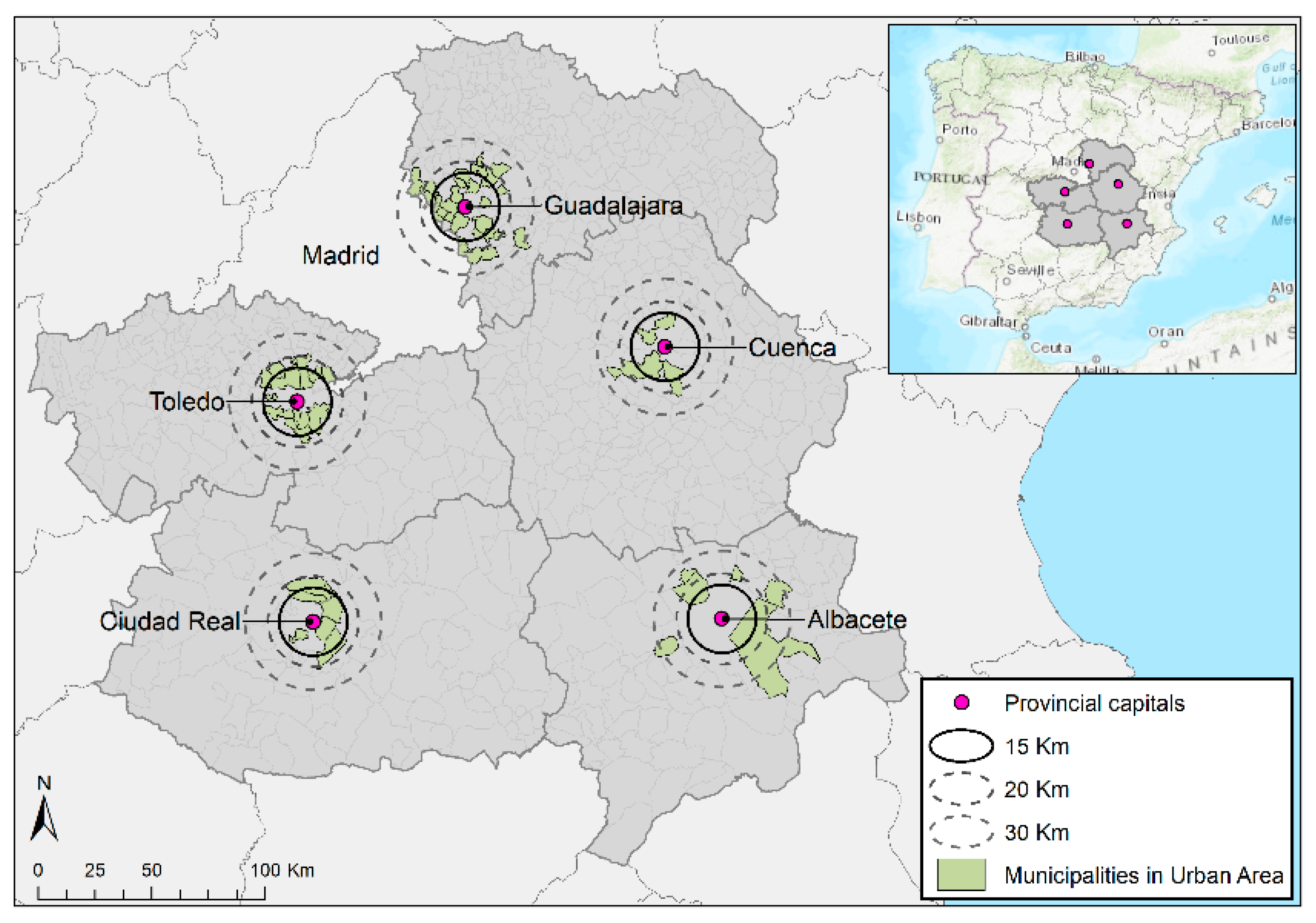
1.3. The Cadastre as a Source for Research on Cities. Application to the Study of Urbanization Dynamics

The processes affecting the demographic, functional and morphological dynamics of cities have traditionally been associated with various stages: urbanization, suburbanization, deurbanization and reurbanization. The growth in the periphery of cities corresponds to suburbanization and deurbanization. The main territorial manifestation of these two stages is urban sprawl, understood as the dimensions of low density, continuity, concentration, clustering, centrality, multi-nuclearity, mixed uses and proximity [58].
This territorial reality has been given many names, such as anti-city [59], urbanized countryside [60], diffused city [61], metapolis [62], city-region [63], the spread-out city [64], postmetropolis [65], metacity [66] and inefficient city [67]. It has become a generalized reality in different sociocultural contexts, and Spain is no exception, having developed with special intensity during the “prodigious decade of Spanish urban growth” [68]. The causes have been analyzed by a number of authors [69,70,71,72]. A critical reading of these works suggests it is the consequence of the dynamic interaction of economic, sociological, cultural and demographic processes. Simply put, it refers to intense growth in housing and population over a short period of time, which in many cases is concentrated outside the existing city.
In the case of Spain, the essential reasons for the development of this city model are associated with the rise in people’s income in the first decade of the 21st century; policies favoring house buying; the arrival of labor immigrants (more than six million between the end of the 20th century and 2010); the increased demand for second homes in coastal areas revitalized by “sun and beach” tourism; the entrance of banks into the real estate sector (from the beginning of the 21st century); the emergence of private speculative investors, changes in the Building Code (1998); the shift from all land being protected to all land being developable, except for protected areas; the influence of development companies in public administrations; the adoption of the euro (2000); and money laundering in the construction industry [72]. In this setting, overaccumulation in the second circuit of capital [73] was channeled into the construction sector, with urban areas being more dynamic, partly because the gains were greater [74]. Moreover, the competent administrations for territorial planning (the regional governments) have been permissive with, and in some cases, drivers of, such practices [71], leading to a situation of land mismanagement [70], which has been criticized in various areas of research.
The above is especially significant if we take into account the fact that cities are considered the center of economic development [75], as well as the scenario in which public policies for sustainable development are implemented, with the implicit idea of process, the systemic foundations of public policy and actions taken with a holistic approach [76]. The European Union has paid special attention to territorial management, with a focus on sustainable urban development, based on an “approach to complex reasoning about land” [77] (p. 155). Urban sustainability is grounded in a multidimensional approach, where various basic factors come into play, such as saving resources, reducing pollution and land use. Such aspects act in conjunction to enhance the population’s quality of life [78]. It cannot be overlooked that any “urbanization process should be oriented towards development of the human race and satisfying its needs” [79]. Urban agendas are drawn up in this line [80], for a city to be made for its inhabitants, and as such, to be at their service [81]. Under the concept of urban sustainability, changes in land cover can be viewed as key components of global change [82] and as direct indicators of human interaction with the landscape [83]. Similarly, changes in land use allow us to analyze sustainability processes as indicators of a country’s model of development [84,85].
The aim of the present work is to highlight the role of cadastral information in the analysis of a city’s morphological transformation, in the context of robust growth of urban sprawl and the increasing need for planning to safeguard urban sustainability. The cadastral parcel is the central variable in this research, and specifically the properties included in each one. A further aim is to use cadastral data to analyze certain aspects of urbanization dynamics, using the growth in numbers of dwellings to analyze the increase in urban sprawl. In particular, we focus on the effects on the medium-sized cities and their respective urban areas in the five provinces that make up the autonomous community of Castilla–La Mancha (Spain). The period covered by the study is 2000–2106. The study provides a novel methodological proposal that permits the analysis of how cities and urban areas grow. The analysis is conducted at the level of property, construction type and age in years.
Considering the methodological proposal developed, we propose the following hypotheses: recent processes of urban transformation can be analyzed by drawing on the evolution and distribution of the surface area, land parcels and real estate, depending on typology. Our initial hypothesis was that the urbanization dynamics in the period under study (2000–2016) were more intense in urban areas than their respective city centers. We also assumed that the changes had occurred under the dynamics of urban sprawl and the predominant construction type was single-family dwellings.
The work is divided into various parts. The introduction reviews the literature on the cadastre as a powerful tool and a source of information for research. The second section explains our methodology, which combines the use of the cadastre as a source of information and statistical and cartographic analysis as an instrument for the scale analysis of urban areas (using alphanumeric and cartographic information) The third section presents the results, whereas the fourth section is devoted to the discussion, intending to underline the role of research on urban areas in understanding cities and territorial planning and management. Finally, the fifth section presents our conclusions.

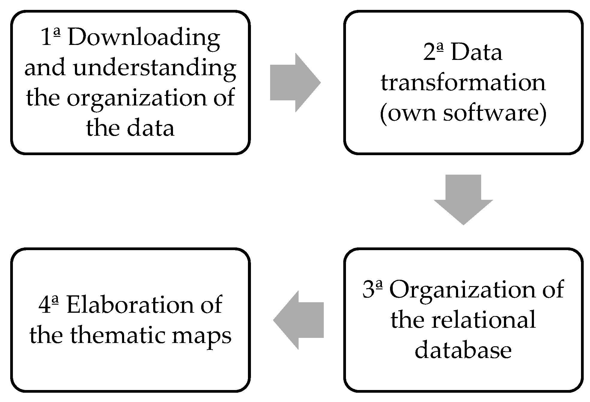
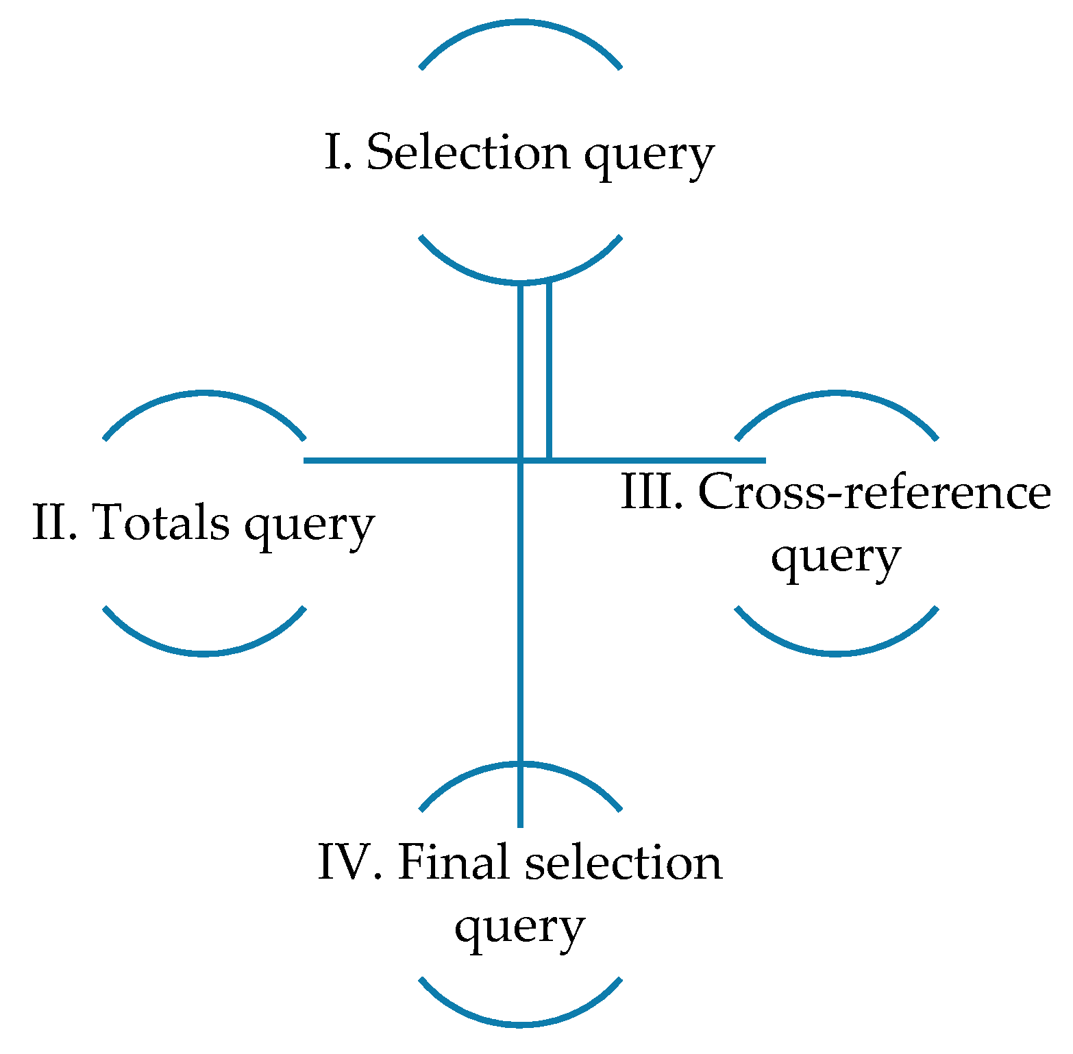
2. Materials and Methods

The main source used in this research is cadastral data, and more specifically, the CAT files, which contain highly useful geographic data [86]. Cadastral data contain detailed quantitative information on rustic and urban parcels and the property registered in each of these. Our analysis was focused on the evolution of a group of municipalities located in urban areas around a number of cities, specifically, the capital cities of the five provinces of Castilla–La Mancha, an inland region of Spain. Based on demographic size in 2020, they could all be considered intermediate cities (between 50,000 and 250,000 inhabitants according to the classification of the Spanish Ministry of Development): Albacete: 174,336; Ciudad Real: 75,504; Cuenca: 54,621; Guadalajara: 87,484; and Toledo: 85,811 (National Statistics Institute (INE): 2021).
The criterion of urban area was defined using urbanization dynamics. First, we selected a 30-km radius around the provincial capitals, accounting for 202 municipalities (including the central cities). To form a proposal of each city’s urban area, we used the analytic hierarchy process (AHP), a multi-criteria analysis method, developed by Saaty in the 1960s [87]. It is defined as “a multi-objective and multi-criteria decision-making approach that uses pairwise comparison to arrive at a scale of preference among a set of alternatives” [88] (p. 286). The applications of this methodology have been very varied and belong to very diverse fields of study [89,90,91,92,93,94]. In the scope of geography, the most relevant studies are related fundamentally with territorial planning [95,96,97].
In this case, it was used to identify the dynamics of urbanization and demographics in the urban areas of the provincial capitals of Castilla–La Mancha. Applying this methodology allowed us to obtain the mean vector as a reference value to order the alternatives in the different rankings. The municipalities included in each of the urban areas are those that obtained a mean value equal to or greater than that of their central city, according to the criteria used, which were as follows: the population growth rates (based on data from INE), the number of urban parcels and their surface area in hectares (data extracted from cadastral statistics) and the number of real properties (taken from cadastral data, as described in the methodology section).
The reference period used in the AHP was 2000–2016. To compare and identify the different dynamics, we analyzed two subperiods: 2000–2008, characterized as one of the most dynamic in the recent history of Spain; and 2009–2016, which corresponds to the subsequent economic crisis. The unit of analysis was generated through exhaustive data cleaning, to obtain the real property (differentiated by period and type of construction) located in each parcel. This methodology comprised four stages (Figure 1).

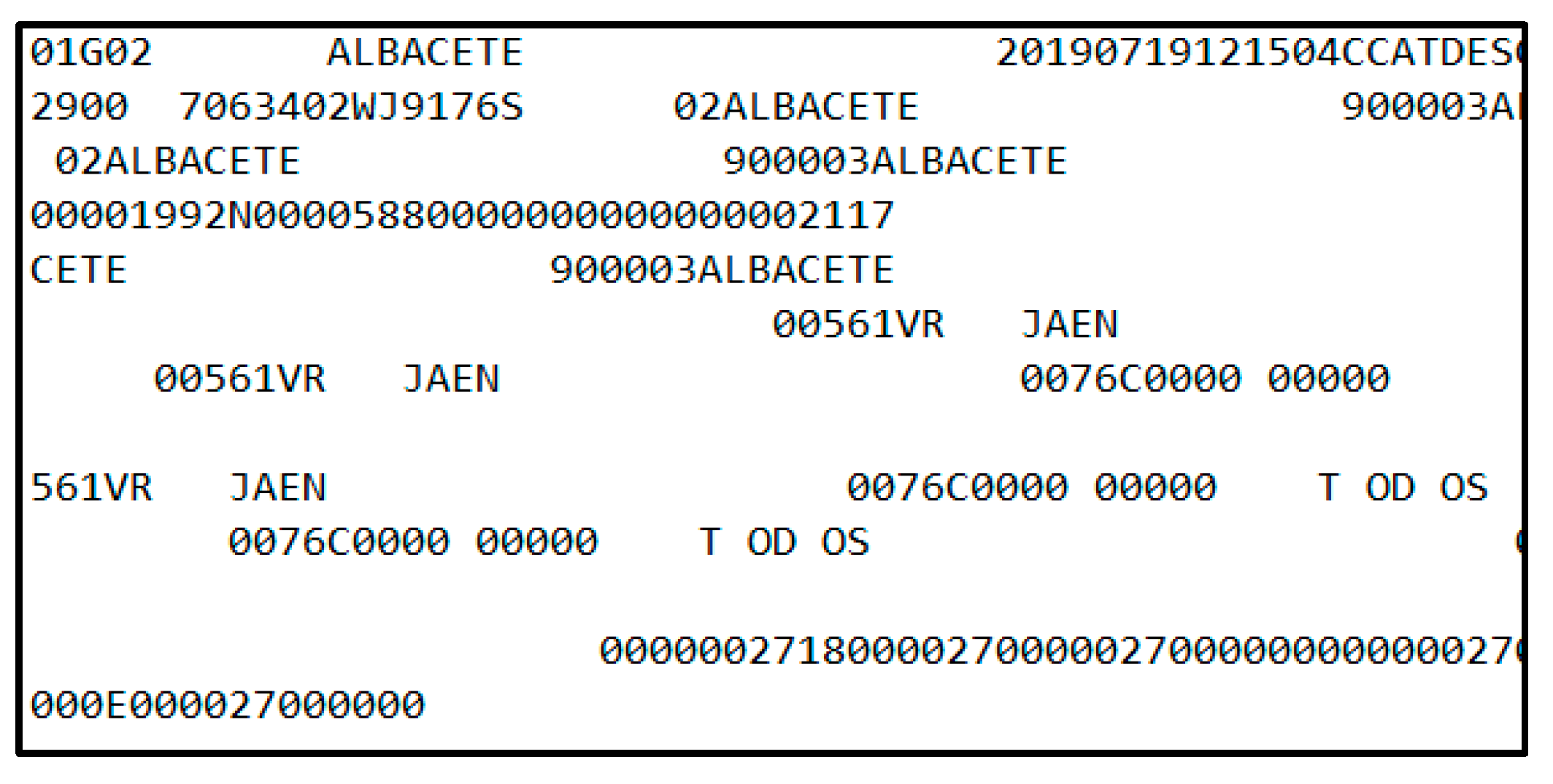
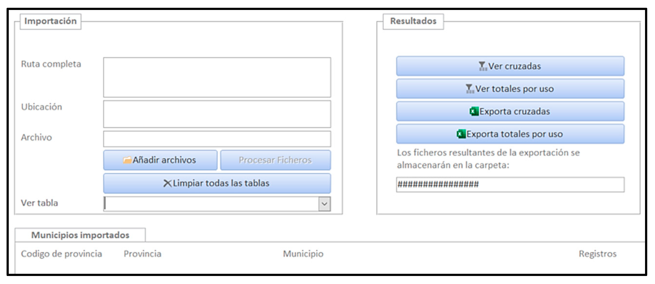
2.1. CAT File Data Processing Methodology

As shown in Figure 1, the methodology used to process the cadastral data from the CAT files comprised four stages—the first three consisted of downloading, transforming and generating alphanumeric information, whereas the fourth entailed linking the data generated from the cadastral maps, also obtained from the cadastre website (Section 2.1.1, Section 2.1.2, Section 2.1.3 and Section 2.1.4 respectively).

2.1.1. Downloading and Understanding the Organization of the Data

One of the main constraints in the process is the fact that the data available on the cadastral statistics portal [98] could not be used, as their structure does not permit their territorialization. To solve this problem, we mass-downloaded unprotected cadastral data for this study, including the vector maps and available alphanumeric data, with all the information on each parcel, except for the ownership and cadastral value of the properties [99]. The methodological process in this first stage included encoding the relational structure of the CAT files, which are flat text files without a line format. This means they must be converted into a database structure format. Each file had information from eight different records, each with its own data structure and different but complementary information. All the data were interrelated (Table 1).
The structure of the cadastral information involves a scheme of interpretation whereby a parcel includes a number of properties and constructed elements. Figure 2 shows five parcels, composed of different real properties with which the constructed elements are associated—24 in this example—which is the same or more than the number of properties.
One of the crucial issues with the source is the presence of occasional inaccuracies or mistakes in some fields, which may affect the final outcomes of the research. In the case of “Year of construction”, the oldest dwellings are typically referenced as 1900, which influences the quality of the information (in this case, only dwellings built after 2000 were used). The age of the property may sometimes vary depending on whether it is a reformed dwelling or not, which explains why, within one parcel, properties of the same type may appear encoded with different years. This question was interpreted as an error in the cadastre because, based on the Type 14 record, we can determine whether a property has been reformed, in the field “indicator of type of reform or renovation, in its event, for the purpose of calculating the age correction coefficient” (possible values—R/O/E/I or blank, where R: complete renovation, O: complete reform, E: intermediate reform, I: minimal reform).
Other errors were found related to construction type. To solve this problem, we established the following codes, after detecting and correcting each individual case:
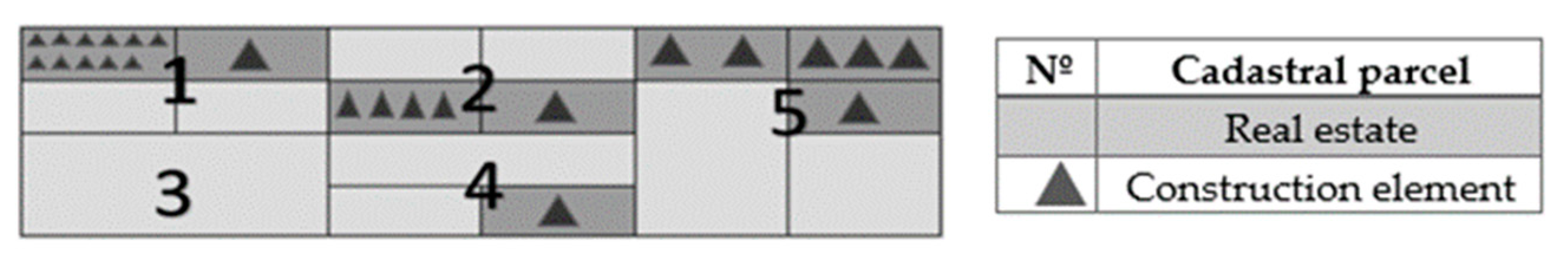
  • 0.0.0. for properties with no type or one type.
  • 0.0.1. for properties with two types (1.1.1. and 1.1.2.) that correspond to urban multi-dwelling buildings, regardless of whether they are open or closed blocks.
  • 0.0.2. for properties with two types (1.2.1 and 1.2.2.) that correspond to urban single-family dwellings, regardless of whether they are detached or semi-detached, terraced or closed blocks.
  • 0.0.3. for properties with contradictory types (dwellings that, following the cadastral type, are both single-family and block dwellings).

2.1.2. Data Transformation

Once the relational model of the data had been determined (as exemplified in Figure 2), and to address the research aims, we designed and developed an analysis tool (software based on the structure of Access). The main aim of this tool was to convert and store the flat-text cadastral information (Figure 3) into a database organized into tables.
The outcome was a data management platform that permits CAT files to be processed (converting the alphanumeric data on the flat-text formatless files into an alphanumeric format fitted to the eight types of record shown in Table 1). The application was generated in the Visual Basic programming language (Figure 4).
Broadly speaking, the tool comprises an import panel, a results panel and an information panel. Its function is to create a table for each of the record types. Despite being an essential stage, it is insufficient, since none of the eight types includes the number of properties at the cadastral parcel scale, its construction typeor the geographic coordinates of where the parcel is located.

2.1.3. Organization of the Relational Database

Once the information was organized into tables, the developed structure determined the variables of analysis for the study. This stage was subdivided into two substages: the first was to filter and prepare the records used (Records 14 and 15 in Table 2); the second was to group this information into a single query. It is worth noting that the aim of the analysis was to identify where, when and how the urban growth occurred in the cities selected. To this end, we determined the number of properties in each of the cadastral parcels, the construction type and the age.
Nonetheless, and as mentioned, the difficulty lies in that this detailed information appears in none of the eight types of records. To find these final variables, we needed to cross-reference Records 14 and 15. To do this, from the original property table for Type 15, we selected the parcels with the field “Type of Property”, the UR (urban) (the possible codes are UR, RU or BI: urban, rural or special properties) and “Group key of properties with special characteristics, or of urban property use” coded as V (residential) (there are 16 possible codes: A, V, I, O, C, K, T, G, Y, E, R, M, P, B, J, Z, which correspond to the uses of storage-parking, residential, office, commercial, sport, shows, leisure and hospitality, culture, religion, urbanization and gardening—unbuilt land, unique building, agricultural storage, agricultural industry and agriculture). From this type of record, we also included the query for the fields of “Cadastral parcel”, “Sequential number of property (Loading number) within the cadastral parcel”, “First control character” and “Second control character”. The sum of the characters of the four fields (14 for the parcel, 4 for the loading number and 1 digit for each control character, with 2 in total) corresponds to the cadastral reference of the property in question (20 digits in total). Based on Record 15, we also included “Number of municipality” and “Year of construction”.
Once the data from Record 15 were processed, we associated the constructed elements with the properties to which they were related. This involved linking Type 14 and 15 records. When the properties and the constructed elements were linked, the records were significantly multiplied, which forced us to readjust the data so that each property corresponded to a construction type and a year of construction. This link was made using the fields of “Cadastral parcel” and “Serial number of fiscal property (loading number to which the value of the construction in the cadastral parcel is attributable)”. To obtain the construction type, the database was filtered again using the Type 14 record: the “Target code according to the code established by the Directorate General for the Cadastre” of construction elements designated as V (no detailed use) (a total of 172 possible codes and their respective descriptions can be consulted in Point 13 (Page 6) “Target code of construction. Description of codes” of the document “Frequently asked questions on CAT format version 1.0” available at: http://www.catastro.minhap.gob.es/documentos/preguntas_frecuentes_formato_CAT.pdf (accessed on 12 March 2021). Although code V is described as no detailed use, it can be observed that these are dwellings, and as in the construction type fields, they are assigned values such as 1.1., 1.2. and/or 1.3., which correspond to records of dwellings of different types), as well as the field “Serial number of fiscal property” (loading number to which the value of the construction in the cadastral parcel is attributable)” when it was not blank (if there is no value in this field, it is a common element and thus must be discarded to avoid posting errors). Furthermore, the construction type in “Construction type according to Technical Valuation Standards” had to coincide with one of those in Table 2 (this can be consulted in Point 16 (Page 8) “Construction: Construction type” of the document “Frequently asked questions on CAT format version 1.0”, available at: http://www.catastro.minhap.gob.es/documentos/preguntas_frecuentes_formato_CAT.pdf, along with all the possible construction types associated with properties (accessed on 12 march 2021) (10 categories divided into 31 types, with 70 specifications).
Figure 5 summarizes the process of creating different queries. Once the relational structure between the tables was created, using the common field “cadastral parcel”, the process was as follows:
The selection query was consulted by (I) applying all the previously mentioned filters. This query yielded the totals query (II) to group the records together and count them. In parallel, and also as a result of query (I), a cross-reference query was generated (III), which served to count the properties by type. Finally, a selection query was created again (IV) to join the results of (I), (II) and (III).

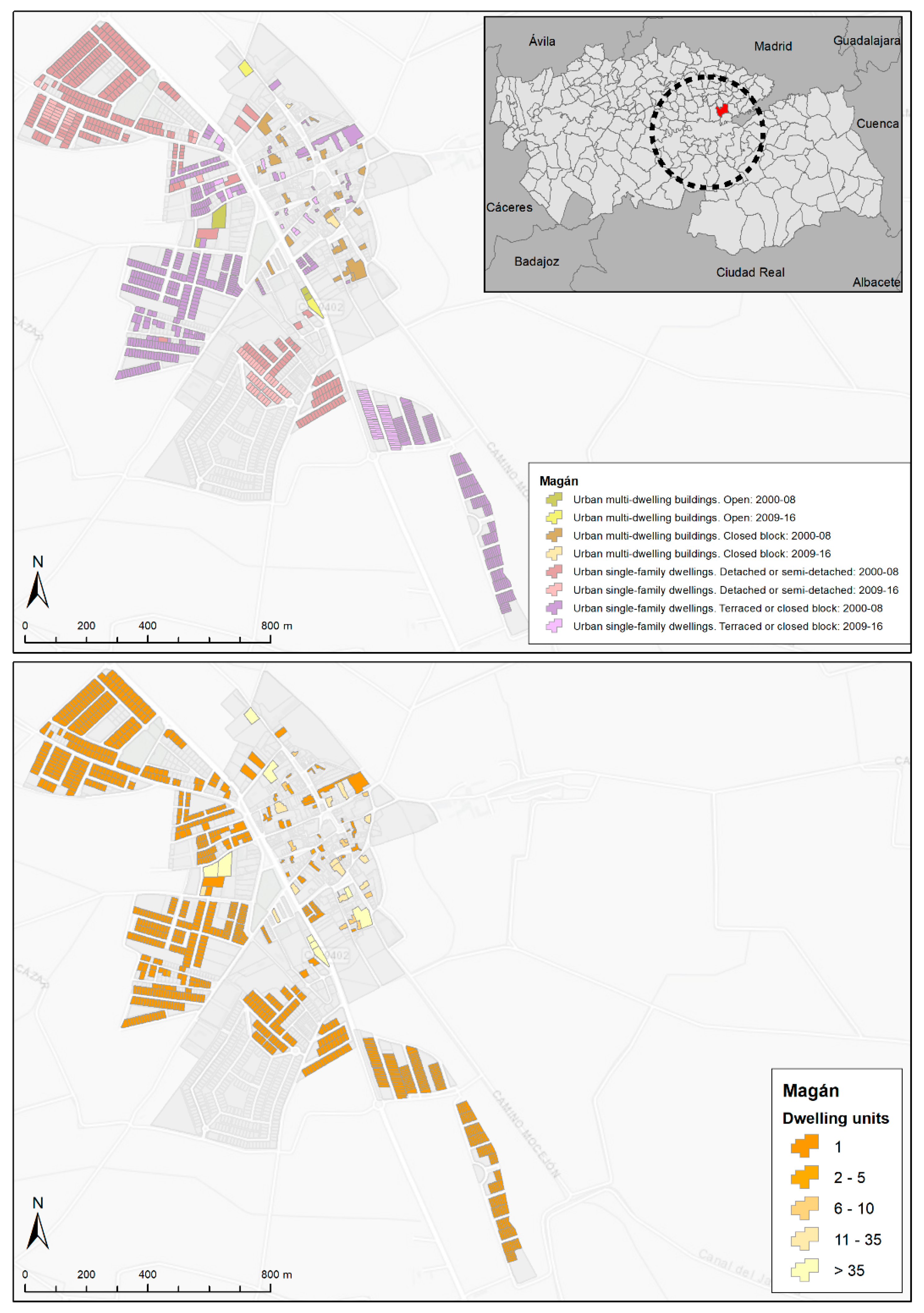
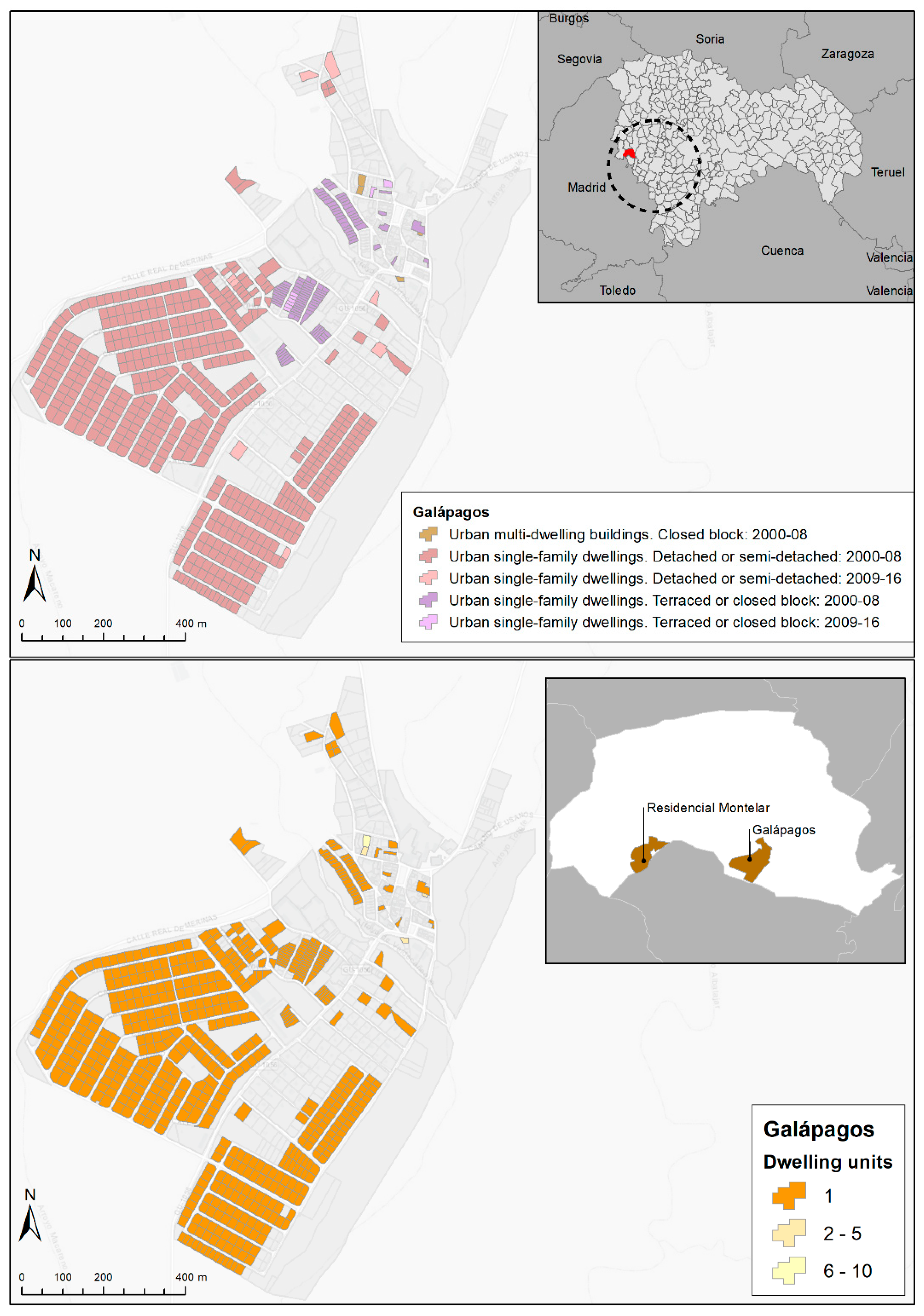
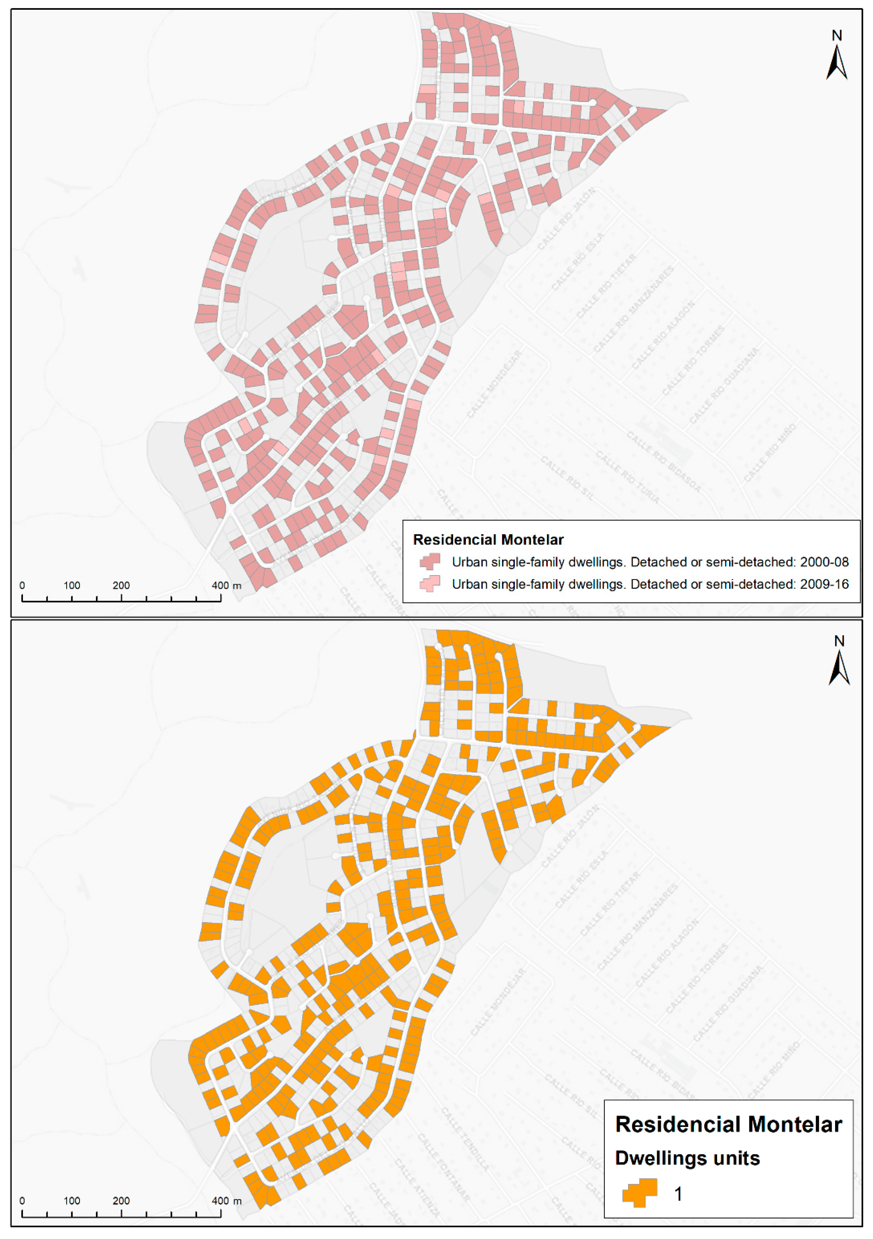
2.1.4. Elaboration of Thematic Maps
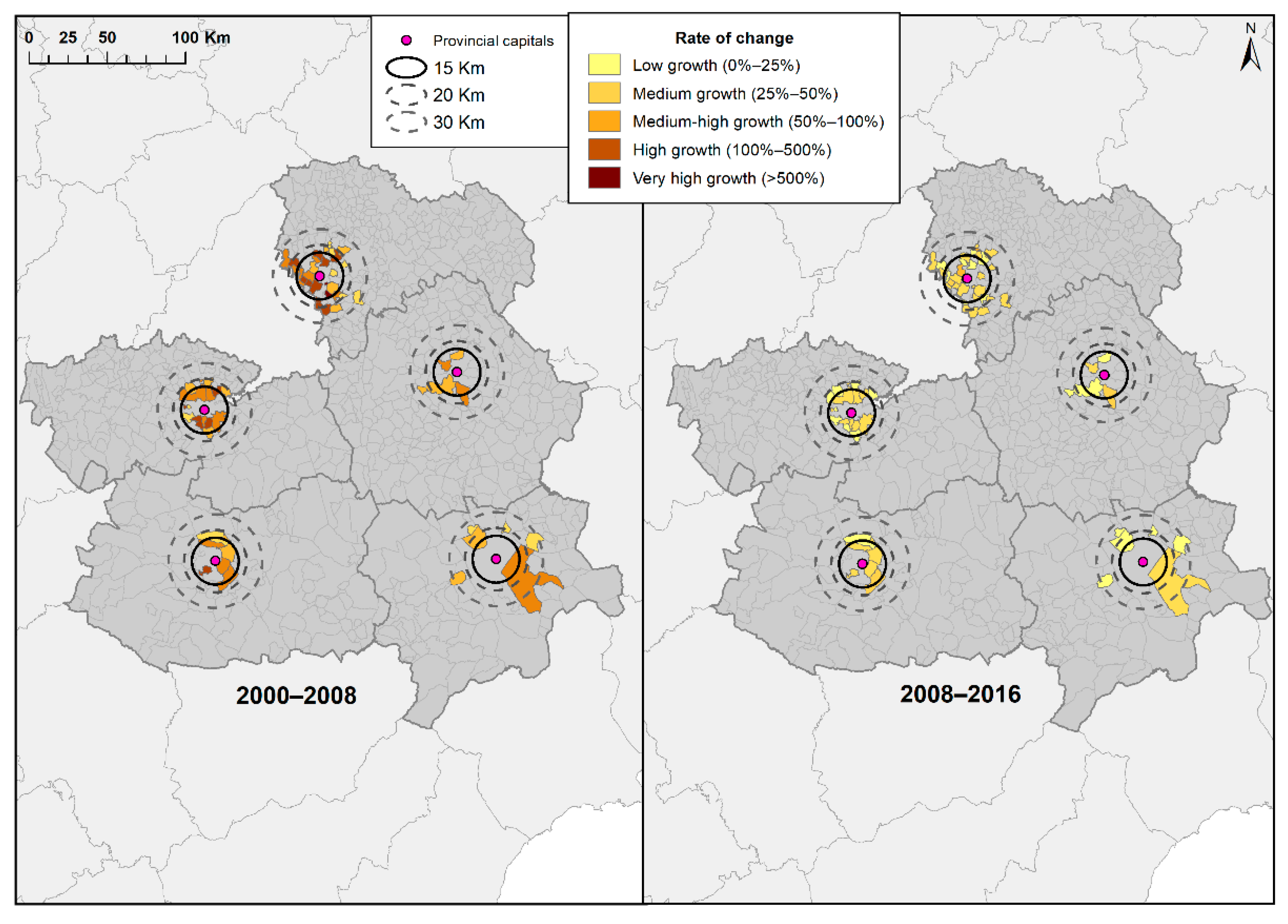
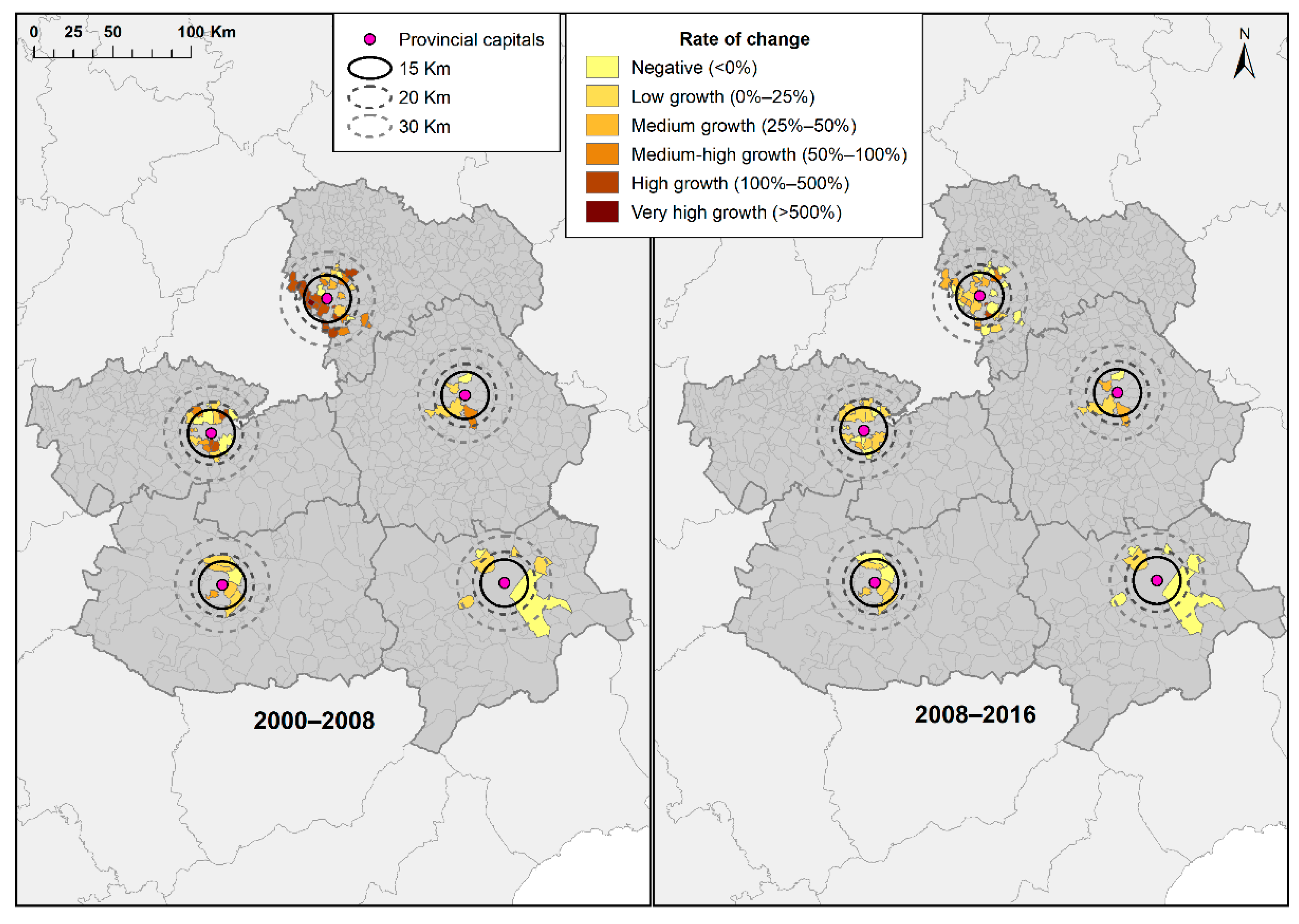
Creation of parcel-scale thematic maps, using the nucleus of population as the reference. The last stage of our proposed methodology allowed for integrated and comparative analyses, drawing on the selected cadastral records. The territorial reference used was the maps downloaded from the cadastre website, specifically the files labeled “urban without history”, available in shapefile format. Each municipality had different layers: “ALTIPUN”, “CARVÍA”, “CONSTRU”, “EJES”, “ELEMLIN”, “ELEMPUN”, “ELEMTEX”, “ERRLIN”, “HOJAS”, “LÍMITES”, “MAPA”, “MASA”, “PARCELA” and “SUBPARCELA”. In this case, we used the “PARCEL” shapefile. The thematic maps produced are the results of linking these files to the data generated from the CAT files.

3. Results

The results of the process allowed us to determine the urban area integrated in the five cities, with the municipalities included in each one (59 municipalities in the five urban areas at city scale, as follows: five municipalities in Albacete, five in Ciudad Real, four in Cuenca, 30 in Guadalajara and 15 in Toledo) (Figure 6). Within each of the areas, we analyzed the behavior of the construction of dwellings in absolute and relative values and by type (multi-dwelling and single-family dwellings). We analyzed two different periods (2000–2008 and 2009–2016). The results obtained were related to their respective central cities, conducting a comparative analysis of the dynamics of the cities and the peripheral municipalities, the latter being understood as manifestations of urban sprawl. The results of our study enabled us to generate an analysis at the parcel level, and, by aggregation, we obtained the information presented in this section for the different cities under study.
From a territorial perspective, these urban areas are characterized by proximity and continuity, as in most cases they include the first ring of municipalities (20 km), which border the area of each capital city. The aggregated data can be used to characterize the cities and their urban areas according to their dynamics and disparate behaviors. It is key to note that the situation of each of the capital cities is different.
Figure 6 and Table 3 show the outcome of this methodology, depicting the process of change over the period 2000–2016. It can be seen that in some urban areas the growth in real property was greater than in the cities to which they belong. This is the case for the city of Guadalajara. The growth dynamic in Toledo is also especially pronounced. The process was less intense in the other three cities, although their urban areas also grew proportionally more than the cities themselves.
The results show that the changes in the dynamics of housing were especially intense in urban areas. The single-family dwelling was clearly the dominant type of property in the period under study. It can also be noted that the increase in dwellings per inhabitant was higher in urban areas than in their respective cities. Finally, the sharpest growth was observed between 2000 and 2008.
The appearance of sprawl-like development has been described as a type of “pollution threatening the quality of the natural environment” [101]. Compact cities consume less land, water and energy [102], and are thus associated with a more sustainable urban model. Nonetheless, there is some support for the model of a diffuse city, with a number of studies (albeit fewer) arguing against compact cities, or at least holding a more balanced position in the debate concerning compact cities vs. diffuse cities [103].
Comparing Figure 7 and Figure 8 highlights two notions that coincide with the discussion in the above paragraphs. Firstly, it is shown that most of the municipalities in all the areas studied in Castilla–La Mancha present housing growth rates that are higher than those of the population. Secondly, across the years analyzed (2000–2016), in the first period (2000–2008) growth was more dynamic, whereas the second period (2008–2016) was characterized by a sharp fall in the growth trend (Figure 7 and Figure 8).
The processes in the first period, which clearly represent the “prodigious decade” of Spanish urban growth [68], helped consolidate the model of a sprawling, low-density city. They feature urban landscapes typified by developments of single-family dwellings. These new patterns of spatial organization generate an inefficient, segregated and unsustainable urban space [104].
The combined analysis of the data provided by the cadastre (alphanumeric CAT files and vector maps) allows us to territorialize the housing behavior by type, according to centers of population over the period 2000–2016. Various examples will show the possibilities of using the cadastre to obtain detailed maps using the absolute data obtained.
The first example is Magán (Figure 9), situated in the urban area of Toledo. The growth in housing in the first study period (2000–2008) was 279%, but 12% in the second. Population growth also reached high levels, although they were lower than those of housing (141% between 2000 and 2008 and 18% between 2008 and 2016). What is striking in the case of this municipality is the expansion of its urban area, following the course of the CM-4058 road, in the form of single-family dwellings (detached, semi-detached, terraced and closed block). Meanwhile, the traditional urban core showed insignificant levels of growth.
The second municipality is Galápagos (in the urban area of Guadalajara) (Figure 10). In this case, population increased at a greater rate than housing across the two study periods. Between 2000 and 2008, demographic growth was 509%, whereas housing grew by 192%. These rates dropped notably over the period 2008–2016, with population increasing by 24% and housing by 3%. The results once more show that the first period (2000–2008) was more dynamic. The urban sprawl expanded from the traditional urban core towards the south. In Galápagos, urban growth was concentrated not only in the limits of the municipality, but also in other, smaller centers of population (such as Residencial Montelar, Figure 11) in the period 2000–2008, with the construction type typically being single-family dwellings (detached and semi-detached).

4. Discussion

The approaches presented in the first two sections of this work deal with the conceptual framework of the city and the process of transformation towards the periphery. These aspects are directly related to the dynamics of the morphological change in urban spaces, to the debate on sustainability and the city model, to the shift in the public administration paradigm from government to governance, as well as to the need for detailed studies based on reliable, updated sources. The territorial delimitation and definition of a city is considered a complex task [105]. Since, 2011, the European Union has defined a city as a local administrative unit with at least 50,000 inhabitants, a population density of more than 1500 inhab/km2 and at least 50% of the population living in one or more urban centers. It forms a functional urban area (FUA), in which more than 75% of the population live in the city center. It includes a commuting zone that includes adjacent administrative units (municipalities), where more than 15% of employed residents work in the city center. Overall, the functional area should comprise a population of over 100,000 [106]. This notion forms part of the complex conceptual debate on territorial reality related to polycentrism [107] (pp. 163–173). In this definition, there is an implicit concept of a city without exact limits, with urban sprawl as a generalized process, and this is one of the key problems to be addressed, namely, defining the territorial scope of a city and its changing dynamics. This requires precise knowledge, identifying the location of new dwellings, the trends over time and the construction types that are dominant in each period. However, while there is no consensus on the definition of city, neither is there one on the definition of the territorial scope of urban areas.
In Mediterranean Europe, cities have historically been characterized by a compact, intense and dense morphology. However, recent decades have witnessed processes of urban sprawl, which have been noticeable at different levels of the urban system, including intermediate cities. Such cities are now typified by the territorial fragmentation of their residential areas and the expansion of their urban sprawl, the formation of urban areas outside a radius of 15–20 km, and the proliferation of single-family dwellings. The urban area, as an actual dimension of a city and as a functional structure, has imprecise limits, which can be explained by the democratization of private vehicles and ICTs (Information and Communication Technologies) and the increasingly densified communication infrastructures [72]. As noted by Boix, “although a city may be similar to a municipal administrative unit, the scope of economic and social interaction tends to exceed the municipal dimensions, spreading to the nearest space” [108].
Urban sprawl processes are undeniably a tangible reality in intermediate Spanish cities [109,110,111]. This has been analyzed in a variety of fields of study and using different sources. A review of the literature reveals diverse findings depending on the scale of analysis, the geographic limits considered and the definition of urban sprawl used. In most cases, attention has focused on urban sprawl, using aerial photography or satellite images [112,113,114]. Consideration has also been given to demographic and construction dynamics, using aggregated data, supported by the opinions of municipal technicians [115,116]. Both approaches, however, are grounded in municipal-scale aggregated data accessed from different sources, with only the demographic information being disaggregated at a significant level.
In such studies, the cadastre has great potential as a source of analysis of urban dynamics and processes. The data it provides enable a high level of disaggregation. It can be applied for different uses: at the administrative level, to determine urban planning parameters; for research on growth and prospective studies on cities; geomarketing; urban indicators to characterize housing stock, etc. [52,111,117,118,119]. However, despite its potential, few applied studies have used data from this source, whereas even fewer have specifically used cadastral parcels as an element to analyze urban transformation processes. However, therein lies a significant part of its functionality, as it enables comprehensive knowledge of territory and boasts extremely valuable territorial information for use by both the public and private sector [120]. The cadastre is highly credible and thoroughly updated, guaranteeing effective management, and “has a significant impact on tax revenue and real estate values, supports urban planning, influences real estate values and effects the procedures of land management” [83] (p. 2). It has, in fact, the capacity to become a key tool for territorial analysis in processes where cadastral real estate is an indisputable reference.
The results of the case study underline the usefulness of the data and the methodology used helps to understand dynamics of urbanization. Nonetheless, there are certain limitations in the use of cadastral data, given that the structure of access complicates their use in research. It should be noted that although the information provided by cadastral statistics is varied and complete, this information cannot be territorialized. It is thus necessary to resort to the CAT files, which contain the parcel identifiers and make it possible to link with the cartographic databases to generate thematic reference maps.
The main drawback is the level of complexity involved in interpreting and extracting the information. In fact, some authors have chosen to “forego the computerized and automated linkage of data from tables on cadastral parcels and data on real estate […] mapping on GIS (Geographic Information System), by manually entering the year of construction, parcel by parcel” [121] (p. 522). Others have opted for a methodology similar to that used in the present study. Rello (2016) resorted to creating a relational database in PostgreSQL to obtain the information on the CAT files and, if necessary, work with variables related to the analysis of residential overcrowding [122]. In any event, even if this system is not available, with the cadastral maps and alphanumeric CAT files, it is possible to territorialize the results.
Nonetheless, despite the difficulties and problems related to the source, the CAT files provide extensive information and enable territorial analysis of cities, the conflicts resulting from their uncontrolled expansion and the sustainability of the urban model that has arisen in recent decades. The use of the land parcel and the number of properties inside them, the year of construction and the type of dwelling help to precisely define the dynamics of change in cities. This study validates its usefulness. In contrast to census information, which is clearly limited by issues of time (it is updated every ten years) and reliability (it is generated by sampling), the information from the cadastre has the advantage of being updated every six months, having extremely detailed information on the parcels and the elements associated with them, as well as having related maps. The multi-purpose cadastre is a highly valid tool in the field of territorial planning and the analysis of urbanization dynamics. Indeed, it is the key component of land administration systems, which, in turn, prioritize efficient and effective land markets [123] and sustainable development [124].

5. Conclusions

The debate on the concept of the city and its limits has numerous implications that affect its definition, but which also impact the growing importance of integrated urban areas in cities. This process has been ongoing since the end of the last century. The spatial, social, economic and environmental effects of urban sprawl have sparked a debate on the sustainability of this model. In fact, urban agendas, underpinned by international declarations, emphasize the need to return to the compact city. In this scenario, cadastral data should be at the heart of research and land-use management. It is necessary to generalize the use of the information available in cadastral databases because it is exact, reliable, updated and highly detailed, which makes it of great use to evaluate urbanization dynamics by analyzing the changes in the distribution of real estate and its age and construction types.
The case study proposed in this work underlines the suitability of cadastral data for the analysis of the different scale dynamics of urbanization, as regards both cities and their urban areas. To date, these analyses have been conducted using sources that allow for little disaggregation of data, thus limiting the validity of findings. The possibility of using urban parcels and real property underlines the need to advance the development of methodologies that permit greater use of the cadastre in urban studies in this research field. The advance in the methodology developed here facilitates the detailed analysis of the events of the period under study, as reflected in the case studies proposed in this work. These reflect the precision of the data generated in terms of the number of dwellings constructed, the types of construction, their location and the evolution over a time series of 16 years. The results show three dimensions of change—in the dynamics of construction, which are more intense in the peripheries than in the central cities, regardless of whether the context is one of economic expansion or recession; in the types of construction, as single-family dwellings have gained in prominence in urban areas, whereas the trend of block dwellings persists in the central cities; and in the lack of definition in the concept of the urban area as an element of analysis and a tool for planning, in a scenario in which suburbanization processes continue to advance. This type of analysis is increasingly necessary and significant given the foreseeable dynamics of the effects of the COVID-19 pandemic in city peripheries.
Using this data should help administrators in the decision-making processes of government and governance of cities, which are of great significance to the much-repeated need for greater urban sustainability. The present work demonstrates the potential of the cadastre in quantifying and representing the processes, but also highlights the scant attention paid to the difficulty in utilizing the data. It is thus necessary to advance methodological proposals that help encourage their use.

Author Contributions

I.S.O.: theoretical, methodological and analytical elaboration, writing—review and editing. F.C.A.: theoretical and conceptual elaboration, writing—review and editing. J.A.G.-G.: theoretical and conceptual elaboration, writing—review and editing. All authors have read and agreed to the published version of the manuscript.

Funding

This research was funded by Ministry of Science, Innovation and Universities, grant number RTI2018-096435-B-C22.

Data Availability Statement

Not applicable.

Acknowledgments

SPANISH MEDIUM-SIZED CITIES: URBANIZATION AND URBAN POLICIES. 40 YEARS OF DEMOCRATIC CITY COUNCILS RTI2018-096435-B-C21 + C22. Subproject: “Processes of change in the urbanization of medium-sized cities and their urban areas: 1979–2019. Project–RTI2018-096435-B-C22. Ministry of Science, Innovation and Universities.

Conflicts of Interest

The authors declare no conflict of interest.

References

  1. Henssen, J. Basic Principles of the Main Cadastral Systems in the World. In Proceedings of the One Day Seminar Held during the Annual Meeting of Commission 7, Cadastre and Rural Land Management, of the International Federation of Surveyors (FIG), Delft, The Netherlands, 16 May 1995. [Google Scholar]
  2. Kaufmann, J.; Steudler, D. CADASTRE 2014. A Vision for a Future Cadastral System; FIG: Rüdlingen, Switzerland, 1998; pp. 1–44. [Google Scholar]
  3. Muñiz, J.C. El Cadastre y la Unión Europea. In I Congreso Internacional sobre Cadastre Unificado Multipropósito; Alcázar, M.A., Ariza, M., García, F.J., Mata, J.L., Ruiz, E., Ureña, S., Eds.; Universidad de Jaen: Jaen, Spain, 2010; pp. 783–804. [Google Scholar]
  4. Comparetti, A.; Salvatore, R. Cadastral Models in EU members states. EQA Environ. Qual. 2019, 33, 55–78. [Google Scholar] [CrossRef]
  5. Ollén, J. La información del territorio en la U.E. Situación y perspectivas. CT Cadastre 2002, 45, 29–36. [Google Scholar]
  6. Ting, L.; Williamson, I. Land Administration and Cadastral Trends: The impact of the Changing Humankind-Land Relationship and Major Global Drivers: The NZ Experience. Surv. Rev. 2013, 36, 154–174. [Google Scholar] [CrossRef]
  7. Enemark, S.; Williamson, I.; Wallace, J. Building modern land administration systems in developed economies. J. Spat. Sci. 2005, 50, 51–68. [Google Scholar] [CrossRef]
  8. Durán, I. Catastreros: The Great Momento of Cadastre in Europe. Available online: http://catastreros.blogspot.com/2016/11/el-gran-momento-del-catastro-en-europa.html (accessed on 12 February 2021).
  9. Alcázar, M.G. Cadastre multipropósito sostenible: Una necesidad inaplazable. Rev. Cart. 2015, 91, 9–33. [Google Scholar] [CrossRef]
  10. Abdul, S.I. Benefits and issues of developing a multi-purpose cadastre. In Proceedings of the XIXth ISPRS Congress: Technical Commission IV: Mapping and Geographic Information Systems, Amsterdam, The Netherlands, 16–23 July 2000; Fritsch, D., Molenaar, M., Eds.; Organising Committee of the XIX International Congress for Photogrammetry and Remote Sensing: Amsterdam, The Netherlands, 2000; Volume XXXIII, pp. 22–29. [Google Scholar]
  11. Duncan, E.; Rahman, A. A multipurpose cadastral framework for developing countries-concepts. Electron. J. Inf. Syst. Dev. Ctries. 2013, 58, 1–16. [Google Scholar] [CrossRef]
  12. National Research Council. Need for a Multipurpose Cadastre; The National Academies Press: Washington, DC, USA, 1980. [Google Scholar] [CrossRef]
  13. Lemmen, C.; Van Der Molen, P.; Van Oosterom, P.; Ploeger, H.; Quak, W.; Stoter, J.; Zevenbergen, J. Un modelo estándar para el ámbito catastral. CT Cadastre 2004, 52, 33–54. [Google Scholar]
  14. Mirón, J. Modelos de organización catastral. In I Congreso Internacional sobre Cadastre Unificado Multipropósito; Alcázar, M.A., Ariza, M., García, F.J., Mata, J.L., Ruiz, E., Ureña, S., Eds.; Universidad de Jaén: Jaén, Spain, 2010; pp. 725–734. [Google Scholar]
  15. Rizzo, F. Politica Fiscale e Sottosviluppo Economico. Riforma Tributaria e Catasto; Tringale Editore: Catania, Italy, 1982. [Google Scholar]
  16. Rizzo, F. La ristrutturazione del catasto. Genio Rurale 1985, 11. Available online: https://acnpsearch.unibo.it/journal/1716/BS024 (accessed on 11 January 2021).
  17. Rizzo, F. Per il Catasto; Facoltà di Ingegneria dell’Università di Catania: Catania, Italy, 1986. [Google Scholar]
  18. Agenzia delle Entrate. The Italian Cadastral System; Central Directorate Cadastre, Cartography and Land Registry: Rome, Italy, 2017; pp. 1–23. [Google Scholar]
  19. Agenzia delle Entrate. The Italian Cadastral System; Central Directorate Cadastre, Cartography and Land Registry: Rome, Italy, 2018; pp. 1–33. [Google Scholar]
  20. Raimundi, S. The Structure of Soil Cadastre. A Model of Soil Inventory Environmental, Social, Economic and Taxation Purposes in a Globalised Market. EQA Int. J. Environ. Qual. 2017, 25, 49–63. [Google Scholar] [CrossRef]
  21. Raimundi, S. La terza branca del catasto del suolo per uno sviluppo sostenibile: Conservazione della biodiversità pedologica e formazione professionale. In Proceedings of the Primo Congresso Congiunto SISS-SIPe: Il Ruolo della Scienza del Suolo per gli Obiettivi dello Sviluppo Sostenibile, Palermo, Italy, 10 September 2018. [Google Scholar]
  22. Raimundi, S.; Puccio, D.; Egli, M. An extra-urban soil cadastre for Italy: A first guide for the introduction of soil information. EQA Int. J. Environ. Qual. 2020, 39, 1–10. [Google Scholar] [CrossRef]
  23. Gibino, A. Conferenza su: Catasto del Suolo Urbano e Sostenibilità del Verde. 2018. Available online: https://www.gdmed.it/2018/07/10/conferenza-su-catasto-del-suolo-urbano-e-sostenibilita-del-verde/ (accessed on 11 January 2021).
  24. Napoli, G. Catasto urbano di Spagna e d’Italia a confronto attraverso alcuni casi-studio. Estimo E Territ. 2003, 66, 10–36. [Google Scholar]
  25. Clergeot, P. The Origins of the French General Cadastre; FIG: Paris, France, 2003; pp. 13–17. [Google Scholar]
  26. Sánchez, J.M. Ancient sources, modern tolos. Napoleonic cadastrre and the Internet. Antzina Rev. Geneal. Vasca E Hist. Local 2010, 10, 39–43. [Google Scholar]
  27. Portal de la Dirección General del Cadastre. Resumen de los Principales Aspectos del Cadastre Francés Tratados en la Reunión de los Cadastre y Registros de España y Francia. 2019. Available online: http://www.catastro.meh.es/documentos/internacional/reuni%C3%B3n%20%20Espa%C3%B1a%20y%20Francia07022019.pdf (accessed on 12 January 2021).
  28. General Tax Directorate. The French Land Administration from the Oigins to Our Days; United Nations Economic Commission for Europe (UN-ECE), Working Party on Land Administration (WPLA), Worshop Customers Cooperation Services: Vienna, Austria, 2002. [Google Scholar]
  29. Castanyer, J. La valoración fiscal de bienes inmuebles en el Derecho Comparado. CT Cadastre 1996, 29, 54–62. [Google Scholar]
  30. Núñez, J.A. La revisión de los valores catastrales en Francia. CT Cadastre 1991, 8, 68–71. [Google Scholar]
  31. Casado, R.; Fernández, R. El Cadastre en Internet. CT Cadastre 2010, 38, 77–88. [Google Scholar]
  32. Ministère de L’Economie Des Finances Et De La Relance. 2021. Available online: https://www.cadastre.gouv.fr/ (accessed on 15 December 2020).
  33. Service du Consultation du plan Cadastral. Legende du Plan Cadastral sur. Available online: Cadastre.gouv.fr (accessed on 12 December 2020).
  34. Miranda, J. Modelos de Gestión Catastral en EUROPA. 2003. Available online: www.cadastrelatino.org (accessed on 12 December 2020).
  35. Rakhmonov, K.; Abdurakhimova, M. Improvement of cadastral information provisioning system in an administrative region. In Proceedings of the Annual International Scientific Conference on Geoinformatics GI 2021, Tashkent, Uzbekistan, 27–29 January 2021; Volume 227. [Google Scholar]
  36. Catalá, R. Discurso de inauguración del congreso. CT Catastro 2002, 45, 9–14. [Google Scholar]
  37. Dawidowicz, A.; Voss, W.; Leonard, B. Land Administration System Development Trends—A case study. Real Estate Manag. Valuat. 2013, 21, 83–92. [Google Scholar] [CrossRef] [Green Version]
  38. Dawidowicz, A.; VoB, W.; Leonard, B. Land Administration Systens Development Trends—Case study of Poland. Real Estate Manag. Valuat. 2017, 25, 112–122. [Google Scholar] [CrossRef] [Green Version]
  39. Permanent Committee on Cadastre in the European Union. Available online: https://www.eurocadastre.org (accessed on 7 January 2021).
  40. Portal de la Dirección General del Catastro. Available online: https://catastro.meh.es (accessed on 7 January 2021).
  41. Real Decreto Legislativo 1/2004, de 5 de Marzo, por el que se Aprueba el Texto Refundido de la Ley del Catastro Inmobiliario; BOE-A-2004-4163. 2004. Available online: https://boe.es/buscar/act.php?id=BOE-A-2004-4163 (accessed on 3 March 2021).
  42. Berné, J.L.; Femenia, C.; Benítez, E. Cadastre y Valoración Catastral; Editorial de la Universitat Politècnica de València: Valencia, Spain, 2004. [Google Scholar]
  43. Llombart, M.J. La modernización del Cadastre en España y su proceso de informatización, 1980–1992. Biblio 3W 2017, XXI, 1–40. [Google Scholar]
  44. Velasco, A. La Actividad Internacional del Cadastre L. Available online: http://www.ingenierosdemontes.org (accessed on 12 February 2021).
  45. Martínez, J.M.; García, J.A.; Escudero, L.A.; Vázquez, C. Aproximación a las dinámicas constructivas de las ciudades medias españolas y sus coronas en el siglo XXI a partir de fuentes catastrales. CT Cadastre 2019, 95, 95–124. [Google Scholar]
  46. Conejo, C. El Sistema de Información Catastral Español. Situación Actual y Estrategias de Renovación Informática y Telemática. Available online: http://www.catastrolatino.org/documentos/cconejoesp.pdf (accessed on 3 March 2021).
  47. De Aragón, F. Proyección Estratégica de la Dirección General del Cadastre. CT Cadastre 2018, 92, 9–22. [Google Scholar]
  48. Moreno, T. El Cadastre como plataforma de servicios para una sociedad digital. CT Cadastre 2018, 92, 127–143. [Google Scholar]
  49. Portal de la Dirección General del Catastro: Estadísticas Catastrales. Available online: www.catastro.minhap.gob.es/esp/estadisticas.asp (accessed on 10 March 2021).
  50. Durán, I. Dos iniciativas para la aproximación de los Cadastres de los países miembros. CT Cadastre 2002, 15–27. [Google Scholar]
  51. Clout, H.D.; Sutton, K. The Cadastre as a source for french rural studies. Agric. Hist. 1969, 43, 215–224. [Google Scholar]
  52. Femenia-Ribera, C.; Mora-Navarro, G.; Coll, E.; Martínez-Llario, J. Trabajos de investigación aplicados a cadastre y registro de la propiedad. In I Congreso Internacional Sobre Cadastre Unificado Multipropósito; Universidad de Jaén: Jaén, Spain, 2010; pp. 1–12. [Google Scholar]
  53. Mou, Z. Using cadastral maps in historical GIS research: The French Concession in Shanghai (1931–1941). Ann. Gis 2012, 18, 147–156. [Google Scholar] [CrossRef]
  54. Törhönen, M.P.; Salzmann, M.; Kasperavicius, R.; Sas, E.; Hokkanen, J.; Rokos, D. Sustainable Governance of European Cadastre and Land Registry Agencies. In Linking Land Tenure and Use for Shared Prosperity, Proceedings of the Annual World Bank Conference on Land and Poverty, Washington DC, USA, 23–27 March 2015; The World Bank: Washington DC, USA, 2015. [Google Scholar]
  55. Dos Anjos, C.; Buffara, A.F.; Camboim, S. A proposal for integrating data of land registry and urban cadastre. Bol. Ciências Geodèsicas 2018, 24. [Google Scholar] [CrossRef]
  56. Erba, D.A.; Piumetto, M.A. Making Land Legible. Cadastres for Urban Planning and Development in Latin America; Lincoln Institute of Land Policy: Cambridge, MA, USA, 2020. [Google Scholar]
  57. Lelo, K. Analysing spatial relationships through the urban cadastre of nineteenth-century Rome. Urban Hist. 2020, 47, 467–487. [Google Scholar] [CrossRef]
  58. Galster, G.; Hanson, R.; Ratcliffe, M.R.; Wolman, H.; Coleman, S. Freihage: Wrestling sprawl to the ground: Defining and measuring an elusive concept. Hous. Policy Debate 2001, 12, 681–717. [Google Scholar] [CrossRef]
  59. Mumford, L. Urban Prospect; Harcourt, Brace & World: New York, NY, USA, 1968. [Google Scholar]
  60. Samonà, G. La cittá in stensione; Stass: Palermo, Italy, 1976. [Google Scholar]
  61. Indovina, F. La Cittá Diffusa; Daest: Venecia, Italy, 1990. [Google Scholar]
  62. Ascher, F. Metápolis ou Lávenir des Villes; Odile Jacob: París, France, 1995. [Google Scholar]
  63. Storper, M. The Regional World: Territorial Development in a Global Economy; Guilford Press: New York, NY, USA; London, UK, 1997. [Google Scholar]
  64. Pumain, D.; Gyerois, M.; Pulus, F. L’etalement urbain in France. Geoinova 2003, 8, 81–102. [Google Scholar]
  65. Soja, E.W. Postmetrópolis. Estudios Críticos Sobre las Ciudades y las Regiones; Traficantes de Sueños: Madrid, Spain, 2008. [Google Scholar]
  66. Martinotti, G. Dalla metrópoli alla meta-città. Le transformazioni urbane all’inizio del seculo XXI. In La Grandi Città Italiane. Società e Territorio da Ricomporte; Dematteis, G., Ed.; Marsilio: Padova, Italy, 2011; pp. 25–76. [Google Scholar]
  67. Fariña, J. Cambiar el modelo urbano. Ciudades 2015, 18, 69–78. [Google Scholar] [CrossRef] [Green Version]
  68. Burriel, E. La década prodigiosa del urbanismo español (1997–2006). Scr. Nova 2008, XII, 270. [Google Scholar]
  69. Gaja, F. El tsunami urbanizador en el litoral mediterráneo. El ciclo de hiperproducción inmobilidaria 1996–2006. Scripta Nova 2008, 12, 270. [Google Scholar]
  70. Romero, J. Construcción residencial y gobierno del territorio en España. De la burbuja especulativa a la recesión. Causas y consecuencias. Cuad. Geogr. 2010, 47, 17–46. [Google Scholar] [CrossRef]
  71. Lois, R.; Piñeira, M.J.; Vives, S. El proceso urbanizador en España (1990–2014): Una interpretación desde la Geografía y la teoría de los circuitos del capital. Scr. Nova 2016, 20. [Google Scholar] [CrossRef]
  72. Cebrián, F. Los procesos de transformación de las ciudades medias. De la ciudad compacta a la metástasis territorial en España. In Dinámicas de Urbanización en Ciudades Medias Interiores ¿Hacia un Urbanismo más Urbano? Cebrián, F. (Coord), Ed.; Tirant Lo Blanc: Valencia, Spain, 2020. [Google Scholar]
  73. Harvey, D. The Urbanization of Capital. Studies in the History and Theory of Capitalist Urbanization; John Hopkins University Press: Baltimore, MD, USA, 1985. [Google Scholar]
  74. Méndez, R. Ciudades en Venta. Estrategias Financieras y Nuevo Ciclo Inmobiliario en España; PUV: Valencia, Spain, 2019. [Google Scholar]
  75. Currid, E. New York as a global creative hub: A comparative analysis of four theories on World cities. Econ. Dev. Quartely 2006, 20, 330–350. [Google Scholar] [CrossRef]
  76. Ornés Vásquez, S. La gestión urbana sostenible: Conceptos, rol de gobierno local y vinculación con el marketing urbano. Provincia 2014, 31, 147–171. [Google Scholar]
  77. Méndez, R.; Prada, J. Ciudades y desarrollo territorial en Castilla-La Manha. Cuatro perspectivas complementarias. In Las Escalas de la Geografía: Del Mundo al Lugar. Homenaje al Profesor Miguel Panadero Moya; Servicio de Publicaciones de Castilla—La Mancha: Cuenca, Spain, 2010; pp. 153–175. [Google Scholar]
  78. Observatorio de la Sostenibilidad en España. Sustainability Local: Una Aproximación Urbana y Rural; Mundi-Prensa: Madrid, Spain, 2008. [Google Scholar]
  79. Girardotti, L.M.; Elementos de Economía Urbana. Nociones de Economía Urbana. Guía de Estudio. Universidad de Buenos Aires, Argentina; 2002. Available online: http://www.materias.fi.uba.ar/6808/contenidos/EconomiaUrbana.pdf (accessed on 9 March 2021).
  80. Pemán-Gavín, I. La Agenda Urbana en el marco europeo. Experiencias internacionales de políticas urbanas. Ciudad Territ. Estud. Territ. 2019, 51, 701–722. [Google Scholar]
  81. Capel, H. El urbanismo, la política y la economía (y viceversa). Una perspectiva comparada. Biblio 3W 2010, XV, 893. [Google Scholar] [CrossRef]
  82. Sun, P.; Xu, Y.; Yu, Z.; Liu, Q.; Xie, B.; Liu, J. Scenario simulation and landscape pattern dynamic changes of land use in the Poverty Belt around Beijing and Tianjin: A case study of Zhangjiakou city, Hebei Province. J. Geogr. Sci. 2016, 26, 272–296. [Google Scholar] [CrossRef]
  83. Cienciala, A.; Sobolewska-Mikulska, K.; Sobura, S. Credibility of the cadastral data on land use and the methodology for their verification and update. Land Use Policy 2021, 102, 105–204. [Google Scholar] [CrossRef]
  84. Costanza, R.; D’Arge, R.; De Groot, R.; Farberk, S.; Grasso, M.; Hannon, B.; Limburg, K.; Naeem, S.; O’Neill, R.V.; Paruelo, J.; et al. The value of the world’s ecosystem services and natural capital. Nature 1997, 387, 253–260. [Google Scholar] [CrossRef]
  85. Prieto, F.; Llanos, M.; Díaz, J.M. Tendencias recientes de la evolución del territorio en España (1987–2005): Causas y efectos sobre la sustainability. Ciudad Territ. Estud. Territ. 2011, 168, 261–278. [Google Scholar]
  86. Sereno, A. La información geográfica en España: Especial referencia a la cartografía catastral. CT Cadastre 2009, 2, 31–54. [Google Scholar]
  87. Saaty, T.L. How to make a decisión: The Analytic hierarchy process. Eur. J. Oper. Res. 1990, 48, 9–26. [Google Scholar] [CrossRef]
  88. Saaty, T.L. The Analytic Hierarchy Process: Decision Making in Complex Environments. In Quantitative Assessment in Arms Control; Springer: Boston, MA, USA, 1984; pp. 285–308. [Google Scholar]
  89. Bahurmoz, M.A. The Analytic Hierarchy Process at Dat Al-Kekma, Saudi Arabia. Interfaces 2003, 33, 70–78. [Google Scholar] [CrossRef] [Green Version]
  90. Bascetin, A. Technical note: An application of the analytic hierarchy process in equipment selection at Orhaneli open pit coal mine. Minin. Technol. 2004, 113, 192–199. [Google Scholar] [CrossRef]
  91. Berumen, S.A.; Llamazares, F. Los Métodos de Decisión Multicriterio y su Aplicación al Análisis del Desarrollo Local. Aplicación de un caso en los Municipios de Castilla y León; Editorial Esic: Madrid, Spain, 2011. [Google Scholar]
  92. Frei, F.; Harker, P. Measuring aggregate process performance using AHP. Eur. J. Oper. Res. 1999, 116, 436–442. [Google Scholar] [CrossRef]
  93. González, A.; Ortigoza, E.; Llamosas, C.; Blanco, G.; Amarilla, R. Multi-criteria analysis of economic complexity transition in emerging economies: The case of Paraguay. Socio-Econ. Plan. Sci. 2019, 68, 100617. [Google Scholar] [CrossRef]
  94. Subramaniam, V.; Lee, G.K.; Hong, G.S.; Wong, Y.S.; Ramesh, T. Dynamic selection of dispatching rules for job shop scheduling. Prod. Plan. Control 2000, 11, 73–81. [Google Scholar] [CrossRef]
  95. Belenguer, M.A. Detección de problemas en la localización de usos del suelo mediante SIG y AHP. El caso de Riba-Roja de Turia (Valencia). Rev. Int. Cienc. Y Tecnol. Inf. Geogr. 2016, 18, 3–24. [Google Scholar]
  96. Da Silva, C.J.; Cardozo, D.O. Evaluación multicriterio y sistemas de información geográfica aplicados a la definición de espacios poteciales para el uso del suelo residencial en Resistencia (Argentina). Rev. Int. Cienc. Y Tecnol. Inf. Geogr. 2015, 16, 23–40. [Google Scholar]
  97. Molero, E.; Grindla, A.L.; Asensio, J.J. Escearios de aptitud y modelización cartográfica del crecimiento urbano mediante técnicas de evaluación multicriterio. Rev. Int. Cienc. Y Tecnol. Inf. Geogr. 2007, 7, 311–325. [Google Scholar]
  98. Sede Electrónica del Catastro. Available online: www.sedecatastro.gob.es (accessed on 14 January 2021).
  99. De Haro, M. La protección de datos de carácter personal en el Cadastre Inmobiliario. CT Cadastre 2007, 60, 75–90. [Google Scholar]
  100. Fichero Informático de Remisión de Cadastre (Bienes Inmuebles Urbanos, Rústicos y de Características Especiales). Available online: http://www.cadastre.minhap.es/ (accessed on 12 January 2020).
  101. Astorkiza, I.; Ferrero, A.M. Expansión urbana y sostenibilidad: Una dicotomía difícil de conciliar. Rev. Esp. Control Externo 2012, 14, 47–78. [Google Scholar]
  102. Anzaldo, C. Expansión urbana y sustentabilidad de las ciudades. In Densidad, Diversidad y Policentrismo: ¿Planeando Ciudades más Sustentables? Montejano, J.A., Caudillo, C.A. (Coords), Eds.; CentroGeo: Consejo Nacional de Ciencia y Tecnología: Ciudad de Mexico, Mexico, 2017; pp. 39–55. [Google Scholar]
  103. Moliní, F.; Salgado, M. Superficie artificial y viviendas unifamiliares en España, dentro del debate entre ciudad compacta y dispersa. BAGE 2010, 54, 125–147. [Google Scholar]
  104. Entrena, F. Procesos de periurbanización y cambios en los modelos de ciudad: Un estudio europeo de casos sobre sus causas y consecuencias. Rev. Sociol. 2005, 78, 59–88. [Google Scholar] [CrossRef] [Green Version]
  105. Navarro, C. Delimitation and goverment of the metropolitan phenomenon in Spain. Annu. Derecho Munic. 2009, 2, 159–184. [Google Scholar]
  106. Eurostat. Project Urban Audit. Available online: http://www.ec.europa.eu./eurostat/statisticsexplained/index.php/Glossary (accessed on 2 October 2020).
  107. Boix, R. Concept and delimitation of metropolitan áreas: An aplication to Spain’s Metropolitan áreas. In Seminario Las Grandes Áreas Metropolitanas Españolas en una Perspectiva Comparada; Centro de Estudios Andaluces, Consejería de la Presidencia, Administración Pública e Interior: Sevilla, Spain, 2007; pp. 1–25. [Google Scholar]
  108. Olazábal, E.; Bellet, C. Procesos de urbanización y artificialización del suelo en las aglomeraciones urbanas españolas (1987–2011). Cuad. Geogr. Univ. Granada 2018, 57, 189–210. [Google Scholar] [CrossRef]
  109. Sánchez, I. La Dispersión Urbana en el Proceso de Reconfiguración Territorial de las Ciudades Medias Interiores. Los Casos de las Capitales de Provincia de Castilla-La Mancha durante el Periodo 2000–2016. Ph.D. Thesis, Universidad de Castilla-La Mancha, Albacete, Spain, 2020. [Google Scholar]
  110. Sánchez, I.; Cebrián, F. El Catastro como fuente para analizar los procesos de dispersión urbana. El ejemplo de una ciudad intermedia, Toledo en el periodo 2000–2016. Rev. CT Cadastre 2019, 95, 45–63. [Google Scholar]
  111. Rubiera, F.; González, V.M.; Pérez, J.L. Urban sprawl in Spain: Differences among cities and causes. Eur. Plan. Stud. 2015, 24, 207–226. [Google Scholar] [CrossRef]
  112. Salgado, E. Dinámicas y Caracterización del Proceso de Urbanización en España (1987–2011). Las Áreas Urbanas Articuladas por Ciudades Medias. Ph.D. Thesis, Universitat de Lleida, Lleida, Spain, 2018. [Google Scholar]
  113. Gálvez, D.; Diaz, P.; Braçe, O.; Garrido-Cumbrera, M. Developing an Index to Measure Sub-municipal Level Urban Sprawl. Soc. Indic. Res. 2017, 140, 929–952. [Google Scholar] [CrossRef]
  114. Serra, P.; Vera, A.; Tulla, A.F.; Salvati, L. Beyond urban-rural dichotomy: Exploring socioeconomic and land-use processes of change in Spain (1991–2011). Appl. Geogr. 2014, 55, 71–81. [Google Scholar] [CrossRef]
  115. Ministerio de Transportes, Movilidad y Agenda Urbana. Atlas Estadístico de las Áreas Urbanas. Available online: www.mitma.es/portal-del-suelo-y-politicas-urbanas/atlas-estadistico-de-las-areas-urbanas (accessed on 22 June 2020).
  116. Chacón, L.; Hernández, D. Urban Cadastre Database Modelling. In 38º International Archives of Photogrammetry and Remote Sensing; International Society for Photogrammetry and Remote Sensing: Amsterdam, Holanda, 2000; Volume XXXIII, Part B4. [Google Scholar]
  117. Mora, R.T.; Céspedes, M.F.; Pérez, J.C.; Pérez, R. Reutilización de datos catastrales para estudios urbanos. In Análisis Espacial y Representación Geográfica: Innovación y Aplicación; De la Riva, J.R., Ibarra, P., Montorio, R., Rodrigues, M., Eds.; Universidad de Zaragoza: Zaragoza, Spain, 2015; pp. 293–304. [Google Scholar]
  118. Pillet, F. El catastro inmobiliario territorial de urbana y rústica en España. Scripta Nova 2008, 12, 274. [Google Scholar]
  119. Waterhout, B.; Zonneveld, W.; Meijers, E. Polycentric Development Policies in Europe: Overview and Debate. Built Environ. 2005, 31, 163–173. [Google Scholar] [CrossRef]
  120. Mjos, L.B. Cadastral development in Norway: The need for improvement. Surv. Rev. 2020, 52, 473–484. [Google Scholar] [CrossRef]
  121. Escudero, L.A. Procesos de urbanización difusos y estructuras urbanas fragmentadas. El caso de Toledo (Castilla-La Mancha, España). Estud. Territ. 2018, L197, 517–538. [Google Scholar]
  122. López, P.R. Obtención y Tratamiento de Datos Públicos de la Dirección General del Cadastre. Análisis de Hacinamiento Residencial en Zaragoza. Master’s Thesis, Universidad de Zaragoza, Zaragoza, Spain, 2016. [Google Scholar]
  123. Williamson, I. Using Cadastres to Support Sustainable Development. In Proceedings of the Spanish IX National Congress of Surveying Engineers TOPCART, Valencia, Spain, 18–21 February 2008. [Google Scholar]
  124. Williamson, I.; Enemark, S.; Wallace, J. Incorporating Sustainable Development Objectives into Land Administration. Shaping the Change. In Proceedings of the XXIII FIG Congress, Munich, Germany, 9–13 October 2006. [Google Scholar]
Figure 1. Methodology for processing the CAT files.
Land 10 00374 g001
Figure 2. Example of organization of cadastral information. Own preparation.
Land 10 00374 g002
Figure 3. Flat-text formatless CAT file. Source: own preparation.
Land 10 00374 g003
Figure 4. Interface of the application generated to process the CAT files. Source: own preparation.
Land 10 00374 g004
Figure 5. Procedure to create queries in the database. Source: Own preparation.
Land 10 00374 g005
Figure 6. Urban areas of Castilla–La Mancha (Spain). Source: own preparation.
Land 10 00374 g006
Figure 7. Rate of change in real estate 2000–2008 and 2008–2016.
Land 10 00374 g007
Figure 8. Rate of change in population 2000–2008 and 2008–2016.
Land 10 00374 g008
Figure 9. Number of dwellings and construction types (Magán). Own elaboration.
Land 10 00374 g009
Figure 10. Number of dwellings and construction types (Galápagos). Own elaboration.
Land 10 00374 g010
Figure 11. Number of dwellings and construction types. Own elaboration.
Land 10 00374 g011
Table 1. Structure of CAT files 1.
Type of RecordName of RecordDescription
Type 01Header recordOne for the whole file, regardless of whether it includes information on only one municipality or various
Type 11Land recordOne for each cadastral parcel involved
Type 13Record of constructed unitOne for each constructed unit in each cadastral parcel
Type 14Record of constructionOne for each construction of each constructed unit in each cadastral parcel
Type 15Record of propertyOne for each property in each cadastral parcel
Type 16Record of distribution of common elementsAt least one for each common element that is shared, whenever it is necessary to specify special shared elements
Type 17Record of agricultural parcelsOne for each agricultural subparcel within each cadastral parcel
Type 90Trailer recordOne for the whole file
1 Computerized cadastre remit file (urban, rural, and special status real estate) [100].
Table 2. Construction types selected 1.
1.1 Urban multi-dwelling buildings    1.1.1. Open
    1.1.2. Closed block
1.2. Urban single-family dwellings    1.2.1. Detached semi-detached
    1.2.2. Terraced or closed block
1.3. Rural building    1.3.1. Exclusive use as dwelling
1 Own preparation, using the document “Frequently asked questions on CAT format version 1.0”.
Table 3. Evolution of population and housing in the five provincial capitals of Castilla–La Mancha and their respective urban areas (2000–2016) 1.
City and Urban Area (UA)Total Multi-Dwelling BuildingsTotal Single-Family DwellingsMulti-Dwelling Buildings 2000–2016Single-Family Dwellings 2000–2016Total Dwellings 2000–2016Population Increase 2000–2008Population Increase 2008–2016Total Population 2016Ratio Inhab/dwg
2000–20082009–20162000–20082009–2016
Albacete12.5054.8141.9331.12873.27311.56084.8336.4488.62916.39721933
UA9602597664831.8594.9866.8455165298.1951454
Ciudad Real8.5512.3501.20121833.9115.48939.4008.2922.60170.9531801
UA2.3741.1792.9065614.7869.63614.4224.5102.86724.1881677
Cuenca6.0121.33087717326.1254.30330.4284.02597250.3731655
UA3014056132258312.5363.3675646843.5101042
Guadalajara7.4042.3322.02527134.3575.81340.1704.4344.39573.8091837
UA5.7551.85016.0872.7929.34237.65446.99634.99815.53274.7151589
Toledo5.0823.1133.05334930.4477.80038.2476.2353.37377.1852018
UA4.4511.1148.0281.6809.05123.13132.18211.5297.73053.5061662
1 Source: Cadastre for dwellings; National Statistics Institute (INE) for population. Own preparation.
Publisher’s Note: MDPI stays neutral with regard to jurisdictional claims in published maps and institutional affiliations.

