Evaluation of Land Suitability Methods with Reference to Neglected and Underutilised Crop Species: A Scoping Review

 , , , and
Abstract
:1. Introduction
2. Methodology
Literature Search
3. Results
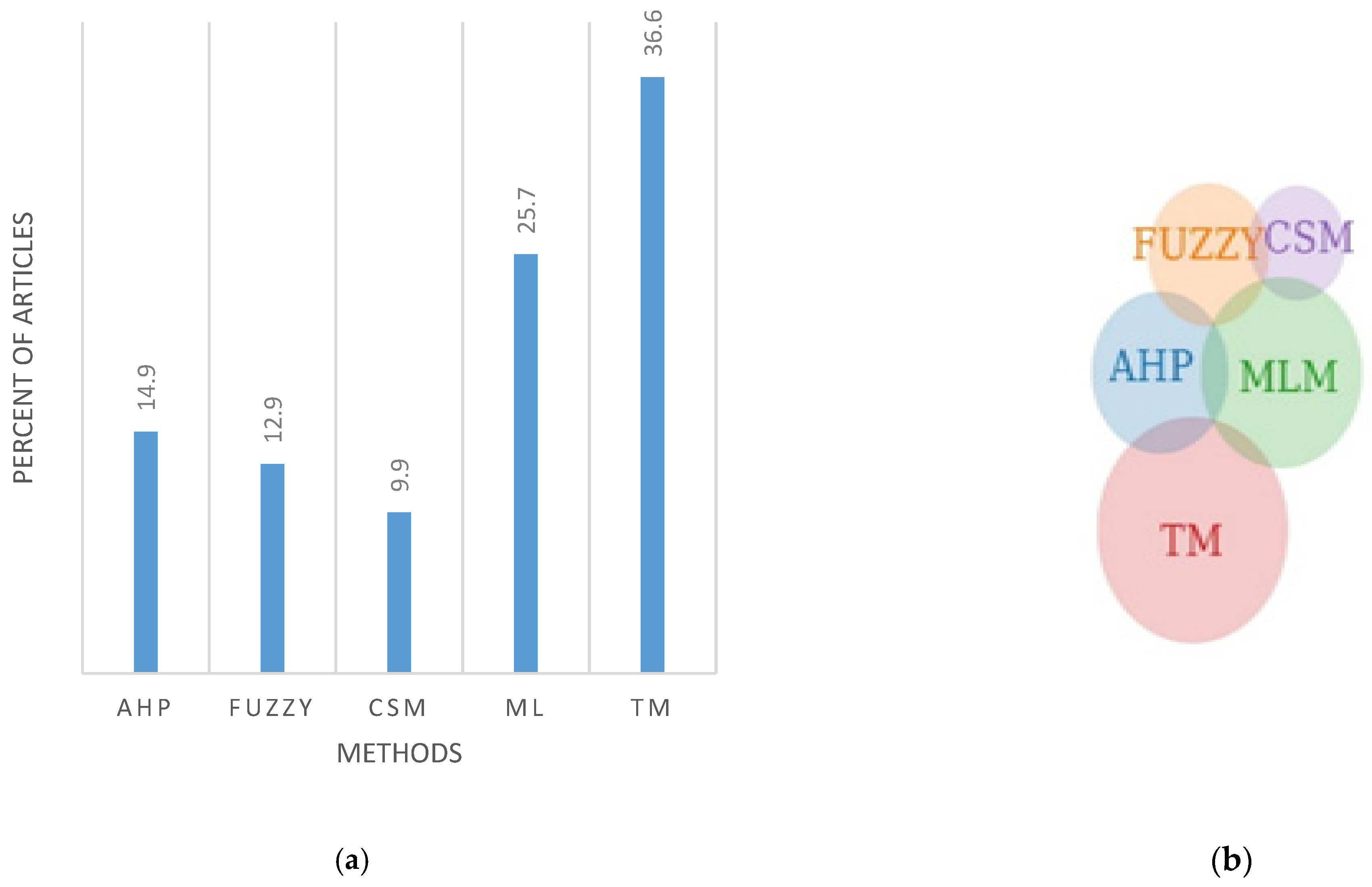
3.1. Results of Literature Search
3.2. Approaches to Land Suitability Analysis
3.2.1. Traditional Land Suitability Methods
The FAO Approach
3.2.2. Modern Land Suitability Approaches
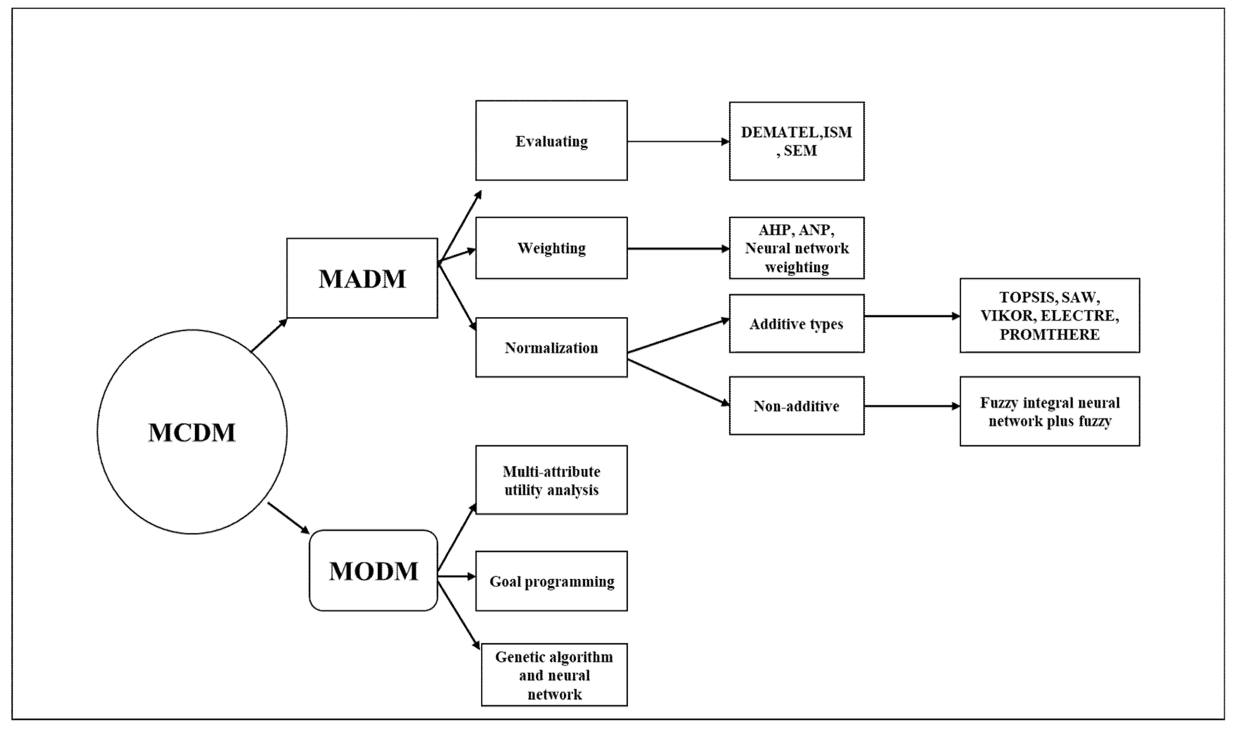
Multi-Criteria Decision Analysis
- Weighting methods (linear additive model, AHP and the multi-attribute utility theory).
- Multiple objective programming (Multi-objective linear programming).
- Outranking approaches (ELECTRE, PROMETHERE).
Analytical Hierarchy Process
- (a)
- “Deriving a pairwise matrix based on a scientific objective in a non-scarce data situation [89]”.
- (b)
- Estimating relative importance of factors individually and based more on scientists’ opinion through a questionnaire or focus group discussions with key informants like the Ministry of Agriculture, the farmers who grow the crops, agronomists and extension officers.
- (c)
- Giving attention to an upper limit, where the upper limit is a consistency ratio (CR) that must be less than 0.1 for a pairwise matrix judgment to be accepted [90]. To minimise the interrelationship among various factors included in the AHP approach, a data reduction method such as principal component analysis (PCA) can combine factors as fewer new variables [74].
- (d)
- The process is based on three principles: decomposition, comparative judgment and synthesis of priorities. Manipulating three principles, for example, synthesis of priorities can be used to evaluate land use opportunity costs, especially when NUS production can complement major crops in semi-arid areas to improve food security.
Fuzzy Logic Technique
Crop Simulation Models
Machine Learning-Related Methods
Species Distribution Models
3.3. Combining Geographic Information System, Remote Sensing and Other Artificial Intelligence Tools
3.4. Hybrid Land Evaluation Systems
3.5. Factors Considered in Crop Suitability Mapping
4. Discussion and Way Forward
5. Recommendations
- To efficiently identify homogenous zones, especially for NUS, hybrid methods are needed—approaches that combine traditional and modern methods (e.g., MCDM, CSM and MLMs). Suitable hybrid land evaluation systems may be useful in handling complexities such as the extreme variability, intermittence and socio-economic factors involved in NUS production.
- The robustness and simplicity of methods differ. Future research should consider using data with a finer resolution to improve the accuracy of mapping. This will help enhance the delineation of land suitability in marginalised agricultural communities that are known to be highly heterogeneous. The application of sensors mounted on unmanned aerial vehicles can validate satellite-derived data and capture high-resolution images [145,146]. The use of data derived from blockchain, cloud computing, big data and IoT technologies can improve the reliability and relevance of land suitability, especially in areas with high ecological risk.
- Future studies should focus on using new predictive tools in forecasting. It is observed that the majority of the studies in resource allocation utilised primitive GIS techniques. Future studies should focus on combining the GEPIC model with other methods to assess spatial distribution and stimulate the production of crops. The GEPIC model is used for predicting crop production levels incorporating near-real-time changes in the crop environment which can be integrated with other techniques for improved decision-making.
6. Conclusions
Supplementary Materials
Author Contributions
Funding
Data Availability Statement
Conflicts of Interest
References
- James, H. Population, Development, and the Environment: Challenges to Achieving the Sustainable Development Goals in the Asia Pacific; Palgrave Macmillan: London, UK, 2019. [Google Scholar]
- UN DESA. World Population Projected to Reach 9.8 Billion in 2050, and 11.2 Billion in 2100. Department of Economic and Social Affairs. Available online: https://www.un.org/development/desa/en/news/population/world-population-prospects-2017.html#:~:text=The%20current%20world%20population%20of,Nations%20report%20being%20launched%20today (accessed on 26 January 2021).
- Onyutha, C. African food insecurity in a changing climate: The roles of science and policy. Food Energy Secur. 2019, 8, e00160. [Google Scholar] [CrossRef] [Green Version]
- Duku, C.; Zwart, S.J.; Van Bussel, L.G.; Hein, L. Quantifying trade-offs between future yield levels, food availability and forest and woodland conservation in Benin. Sci. Total Environ. 2018, 1581–1589. [Google Scholar] [CrossRef]
- Toulmin, C. Securing land and property rights in sub-Saharan Africa: The role of local institutions. Land Use Policy 2009, 26, 10–19. [Google Scholar] [CrossRef]
- Thornton, P.K.; Herrero, M. Adapting to climate change in the mixed crop and livestock farming systems in sub-Saharan Africa. Nat. Clim. Chang. 2015, 5, 830–836. [Google Scholar] [CrossRef]
- Chivenge, P.; Mabhaudhi, T.; Modi, A.; Mafongoya, P. The Potential Role of Neglected and Underutilised Crop Species as Future Crops under Water Scarce Conditions in Sub-Saharan Africa. Int. J. Environ. Res. Public Health 2015, 12, 5685–5711. [Google Scholar] [CrossRef] [Green Version]
- Mabhaudhi, T.; Chimonyo, V.; Modi, A.T. Status of Underutilised Crops in South Africa: Opportunities for Developing Research Capacity. Sustainability 2017, 9, 1569. [Google Scholar] [CrossRef] [Green Version]
- Mabhaudhi, T.; Chimonyo, V.G.P.; Hlahla, S.; Massawe, F.; Mayes, S.; Nhamo, L.; Modi, A.T. Prospects of orphan crops in climate change. Planta 2019, 250, 695–708. [Google Scholar] [CrossRef] [Green Version]
- Hermann, M.; Kwek, M.; Khoo, T.; Amaya, K. Collective action towards enhanced knowledge management of neglected and underutilised species: Making use of internet opportunities. Acta Hortic. 2013, 979, 65–77. [Google Scholar] [CrossRef]
- Akinola, R.; Pereira, L.; Mabhaudhi, T.; De Bruin, F.-M.; Rusch, L. A Review of Indigenous Food Crops in Africa and the Implications for more Sustainable and Healthy Food Systems. Sustainability 2020, 12, 3493. [Google Scholar] [CrossRef] [Green Version]
- Ceballos-Silva, A.; López-Blanco, J. Delineation of suitable areas for crops using a Multi-Criteria Evaluation approach and land use/cover mapping: A case study in Central Mexico. Agric. Syst. 2003, 77, 117–136. [Google Scholar] [CrossRef]
- Sekiyama, T.; Nagashima, A. Solar Sharing for Both Food and Clean Energy Production: Performance of Agrivoltaic Systems for Corn, A Typical Shade-Intolerant Crop. Environment 2019, 6, 65. [Google Scholar] [CrossRef] [Green Version]
- Hopkins, L.D. Methods for Generating Land Suitability Maps: A Comparative Evaluation Methods for Generating Land Suitability Maps: A Comparative Evaluation. J. Am. Inst. Plan. 1977, 43, 386–400. [Google Scholar] [CrossRef]
- Kazemi, H.; Akinci, H. A land use suitability model for rainfed farming by Multi-criteria Decision-making Analysis (MCDA) and Geographic Information System (GIS). Ecol. Eng. 2018, 116, 1–6. [Google Scholar] [CrossRef]
- Malczewski, J. GIS-based multicriteria decision analysis: A survey of the literature. Int. J. Geogr. Inf. Sci. 2006, 20, 703–726. [Google Scholar] [CrossRef]
- Malczewski, J. GIS-based land-use suitability analysis: A critical overview. Prog. Plan. 2004, 62, 3–65. [Google Scholar] [CrossRef]
- Bera, S. Land Suitability Analysis for Agricultural Crop using Remote Sensing and GIS a Case Study of Purulia District Land Suitability Analysis for Agricultural Crop using Remote Sensing and GIS—A Case Study of Purulia District. IJSRD-Int. J. Sci. Res. Dev. 2017, 5, 999–1024. [Google Scholar]
- Akpoti, K.; Kabo-Bah, A.T.; Zwart, S.J. Agricultural land suitability analysis: State-of-the-art and outlooks for integration of climate change analysis. Agric. Syst. 2019, 173, 172–208. [Google Scholar] [CrossRef]
- Akıncı, H.; Özalp, A.Y.; Turgut, B. Agricultural land use suitability analysis using GIS and AHP technique. Comput. Electron. Agric. 2013, 97, 71–82. [Google Scholar] [CrossRef]
- Abdelrahman, M.A.; Natarajan, A.; Hegde, R. Assessment of land suitability and capability by integrating remote sensing and GIS for agriculture in Chamarajanagar district, Karnataka, India. Egypt. J. Remote Sens. Space Sci. 2016, 19, 125–141. [Google Scholar] [CrossRef] [Green Version]
- Singha, C.; Swain, K.C. Land suitability evaluation criteria for agricultural crop selection: A review. Agric. Rev. 2016, 37, 125–132. [Google Scholar] [CrossRef] [Green Version]
- McDowell, R.; Snelder, T.; Harris, S.; Lilburne, L.; Larned, S.; Scarsbrook, M.; Curtis, A.; Holgate, B.; Phillips, J.; Taylor, K. The land use suitability concept: Introduction and an application of the concept to inform sustainable productivity within environmental constraints. Ecol. Indic. 2018, 91, 212–219. [Google Scholar] [CrossRef]
- Araújo, M.B.; Peterson, A.T. Uses and misuses of bioblamtic envelope modeling. Ecology 2012, 93, 1527–1539. [Google Scholar] [CrossRef] [PubMed] [Green Version]
- Phillips, S.J.; Anderson, R.P.; Schapire, R.E. Maximum entropy modeling of species geographic distributions. Ecol. Model. 2006, 190, 231–259. [Google Scholar] [CrossRef] [Green Version]
- Atoyebi, J.O.; Osilesi, O.; Adebawo, O.; Abberton, M. Evaluation of Nutrient Parameters of Selected African Accessions of Bambara Groundnut (Vigna subterranea (L.) Verdc.). Am. J. Food Nutr. 2017, 5, 83–89. [Google Scholar] [CrossRef] [Green Version]
- Hopkins, L.D. Methods for Generating Land Suitability Maps: A Comparative Evaluation. In The Ecological Design and Planning Reader; Island Press: Washington, DC, USA, 2014; pp. 348–367. [Google Scholar] [CrossRef]
- Moher, D.; Liberati, A.; Tetzlaff, J.; Altman, D.G.; The PRISMA Group. Preferred Reporting Items for Systematic Reviews and Meta-Analyses: The PRISMA Statement. PLoS Med. 2009, 6, e1000097. [Google Scholar] [CrossRef] [Green Version]
- Williams, J.T.; Haq, N. Global Research on Underutilized Crops: Assessment of Current Activities and Proposals for Enhanced Cooperation; International Centre for Underutilised Crops: Southampton, UK, 2000. [Google Scholar]
- Kahsay, A.; Haile, M.; Gebresamuel, G.; Mohammed, M.; Moral, M.T. Land suitability analysis for sorghum crop production in northern semi-arid Ethiopia: Application of GIS-based fuzzy AHP approach. Cogent Food Agric. 2018, 4, 1–24. [Google Scholar] [CrossRef]
- Ohadi, S.; Littlejohn, M.; Mesgaran, M.; Rooney, W.; Bagavathiannan, M. Surveying the spatial distribution of feral sorghum (Sorghum bicolor L.) and its sympatry with johnsongrass (S. halepense) in South Texas. PLoS ONE 2018, 13, e0195511. [Google Scholar] [CrossRef] [Green Version]
- Ramirez-Villegas, J.; Jarvis, A.; Läderach, P. Empirical approaches for assessing impacts of climate change on agriculture: The EcoCrop model and a case study with grain sorghum. Agric. For. Meteorol. 2013, 170, 67–78. [Google Scholar] [CrossRef]
- Herzberg, R.; Pham, T.G.; Kappas, M.; Wyss, D.; Tran, C.T. Multi-Criteria Decision Analysis for the Land Evaluation of Potential Agricultural Land Use Types in a Hilly Area of Central Vietnam. Land 2019, 8, 90. [Google Scholar] [CrossRef] [Green Version]
- Purnamasari, R.A.; Noguchi, R.; Ahamed, T. Land suitability assessments for yield prediction of cassava using geospatial fuzzy expert systems and remote sensing. Comput. Electron. Agric. 2019, 166, 105018. [Google Scholar] [CrossRef]
- Gaiser, T.; Graef, F. Optimisation of a parametric land evaluation method for cowpea and pearl millet production in semi-arid regions. Agronomie 2001, 21, 705–712. [Google Scholar] [CrossRef]
- Chen, L.; Messing, I.; Zhang, S.; Fu, B.; Ledin, S. Land use evaluation and scenario analysis towards sustainable planning on the Loess Plateau in China—Case study in a small catchment. Catena 2003, 54, 303–316. [Google Scholar] [CrossRef]
- Habibie, M.I.; Noguchi, R.; Shusuke, M.; Ahamed, T. Land suitability analysis for maize production in Indonesia using satellite remote sensing and GIS-based multicriteria decision support system. Geojournal 2019, 1–31. [Google Scholar] [CrossRef]
- Neitsch, C.; Golden, M.; Hossner, L. Land Capability Classification. J. Am. Soc. Min. Reclam. 1997, 1997, 141–151. [Google Scholar] [CrossRef]
- Teixeira, E.I.; Fischer, G.; Van Velthuizen, H.; Walter, C.; Ewert, F. Global hot-spots of heat stress on agricultural crops due to climate change. Agric. For. Meteorol. 2013, 170, 206–215. [Google Scholar] [CrossRef]
- Bagherzadeh, A.; Gholizadeh, A. Modeling land suitability evaluation for wheat production by parametric and TOPSIS approaches using GIS, northeast of Iran. Model. Earth Syst. Environ. 2016, 2, 1–11. [Google Scholar] [CrossRef] [Green Version]
- Bagherzadeh, A.; Ghadiri, E.; Darban, A.R.S.; Gholizadeh, A. Land suitability modeling by parametric-based neural networks and fuzzy methods for soybean production in a semi-arid region. Model. Earth Syst. Environ. 2016, 2. [Google Scholar] [CrossRef] [Green Version]
- Danvi, A.; Jütten, T.; Giertz, S.; Zwart, S.J.; Diekkrüger, B. A spatially explicit approach to assess the suitability for rice cultivation in an inland valley in central Benin. Agric. Water Manag. 2016, 177, 95–106. [Google Scholar] [CrossRef]
- Deng, F.; Li, X.; Wang, H.; Zhang, M.; Li, R.; Li, X. GIS-based assessment of land suitability for alfalfa cultivation: A case study in the dry continental steppes of northern China. Span. J. Agric. Res. 2014, 12, 364–375. [Google Scholar] [CrossRef] [Green Version]
- Estes, L.; Bradley, B.A.; Beukes, H.; Hole, D.G.; Lau, M.; Oppenheimer, M.G.; Schulze, R.; Tadross, M.; Turner, W.R. Comparing mechanistic and empirical model projections of crop suitability and productivity: Implications for ecological forecasting. Glob. Ecol. Biogeogr. 2013, 22, 1007–1018. [Google Scholar] [CrossRef]
- Jiao, L.; Liu, Y. Model of land suitability evaluation based on computational intelligence. Geospat. Inf. Sci. 2007, 10, 151–156. [Google Scholar] [CrossRef]
- Manna, P.; Basile, A.; National, I.; Bonfante, A.; National, I.; Terribile, F. Comparative approaches from empirical to mecha-nistic simulation modelling in Land Evaluation studies. EGU General Assembly Conference Abstracts. 2009, p. 7475. Available online: https://ui.adsabs.harvard.edu/abs/2009EGUGA..11.7475M/abstract (accessed on 26 January 2021).
- Pilehforooshha, P.; Karimi, M.; Taleai, M. A GIS-based agricultural land-use allocation model coupling increase and decrease in land demand. Agric. Syst. 2014, 130, 116–125. [Google Scholar] [CrossRef]
- Van Lanen, H.; Van Diepen, C.; Reinds, G.; De Koning, G.; Bulens, J.; Bregt, A. Physical land evaluation methods and GIS to explore the crop growth potential and its effects within the European communities. Agric. Syst. 1992, 39, 307–328. [Google Scholar] [CrossRef]
- Jafarzadeh, A.; Alamdari, P.; Neyshabouri, M.; Saedi, S. Land suitability evaluation of bilverdy research station for wheat, barley, alfalfa, maize and safflower. Soil Water Res. 2008, 3, S81–S88. [Google Scholar] [CrossRef] [Green Version]
- López-Blanco, J.; Pérez-Damián, J.L.; Conde-Álvarez, A.C.; Gómez-Díaz, J.D.; Monterroso-Rivas, A.I. Land suitability levels for rainfed maize under current conditions and climate change projections in Mexico. Outlook Agric. 2018, 47, 181–191. [Google Scholar] [CrossRef]
- Raza, S.M.H.; Mahmood, S.A.; Khan, A.A.; Liesenberg, V. Delineation of Potential Sites for Rice Cultivation Through Multi-Criteria Evaluation (MCE) Using Remote Sensing and GIS. Int. J. Plant. Prod. 2018, 12, 1–11. [Google Scholar] [CrossRef] [Green Version]
- Seyedmohammadi, J.; Sarmadian, F.; Jafarzadeh, A.A.; Ghorbani, M.A.; Shahbazi, F. Application of SAW, TOPSIS and fuzzy TOPSIS models in cultivation priority planning for maize, rapeseed and soybean crops. Geoderma 2018, 310, 178–190. [Google Scholar] [CrossRef]
- Bodaghabadi, M.B.; Casasnovas, J.A.M.; Khakili, P.; Masihabadi, M.H.; Gandomkar, A. Assessment of the FAO traditional land evaluation methods, A case study: Iranian Land Classification method. Soil Use Manag. 2015, 31, 384–396. [Google Scholar] [CrossRef] [Green Version]
- Nordgren, R. Introduction to Scientific Programming and Simulation Using R (2nd Edition). J. Stat. Softw. 2016, 78, 1–4. [Google Scholar] [CrossRef] [Green Version]
- Ebrahim, F. A Land Suitability Evaluation for Improved Subsistence Agriculture Using GIS: The Case Study of Nkwezela, KwaZulu-Natal, South Africa. Master’s Thesis, University of KwaZulu-Natal, Pietermaritzburg, South Africa, 2007. [Google Scholar]
- Kaim, A.; Cord, A.F.; Volk, M. A review of multi-criteria optimization techniques for agricultural land use allocation. Environ. Model. Softw. 2018, 105, 79–93. [Google Scholar] [CrossRef]
- Mendoza, G.; Martins, H. Multi-criteria decision analysis in natural resource management: A critical review of methods and new modelling paradigms. For. Ecol. Manag. 2006, 230, 1–22. [Google Scholar] [CrossRef]
- Ghansah, B.; Forkuo, E.K.; Osei, E.F.; Appoh, R.K.; Asare, M.Y.; Klutse, N.A.B. Mapping the spatial distribution of small reservoirs in the White Volta Sub-basin of Ghana. Remote Sens. Appl. Soc. Environ. 2018, 9, 107–115. [Google Scholar] [CrossRef]
- Gibbs, H.K.; Salmon, J. Mapping the world’s degraded lands. Appl. Geogr. 2015, 57, 12–21. [Google Scholar] [CrossRef]
- Liebig, J. Ueber die Darstellung des Wasserglases auf nassem Wege. Eur. J. Org. Chem. 1857, 102, 101–104. [Google Scholar] [CrossRef]
- El Baroudy, A. Mapping and evaluating land suitability using a GIS-based model. Catena 2016, 140, 96–104. [Google Scholar] [CrossRef]
- Hoseini, Y.; Kamrani, M. Using a fuzzy logic decision system to optimize the land suitability evaluation for a sprinkler irrigation method. Outlook Agric. 2018, 47, 298–307. [Google Scholar] [CrossRef]
- Silva-Gallegos, J.J.; Aguirre-Salado, C.; Miranda-Aragón, L.; Sánchez-Díaz, G.; Valdez-Lazalde, J.R.; Pedroza-Carneiro, J.W.; Flores-Cano, J.A. Locating Potential Zones for Cultivating Stevia rebaudiana in Mexico: Weighted Linear Combination Approach. Sugar Tech. 2017, 19, 206–218. [Google Scholar] [CrossRef]
- Hassan, I.; Javed, M.A.; Asif, M.; Luqman, M.; Ahmad, S.R.; Ahmad, A.; Akhtar, S.; Hussain, B. Weighted overlay based land suitability analysis of agriculture land in azad jammu and kashmir using gis and ahp. Pakistan J. Agric. Sci. 2020, 57, 1509–1519. [Google Scholar] [CrossRef]
- Ghanbarie, E.; Jafarzadeh, A.A.; Shahbazi, F.; Servati, M. Comparing Parametric Methods (the Square Root and the Storie) with the Fuzzy Set Theory for Land Evaluation of Khaje Region for Wheat. Int. J. Adv. Biotechnol. Res. 2016, 7, 343–351. [Google Scholar]
- Leroux, L.; Castets, M.; Baron, C.; Escorihuela, M.J.; Bégué, A.; Seen, D.L. Maize yield estimation in West Africa from crop process-induced combinations of multi-domain remote sensing indices. Eur. J. Agron. 2019, 108, 11–26. [Google Scholar] [CrossRef]
- Munene, P.; Chabala, L.M.; Mweetwa, A.M. Land Suitability Assessment for Soybean (Glycine max (L.) Merr.) Production in Kabwe District, Central Zambia. J. Agric. Sci. 2017, 9, 74. [Google Scholar] [CrossRef] [Green Version]
- Kurukulasuriya, P.; Mendelsohn, R. How Will Climate Change Shift Agro-Ecological Zones and Impact African Agriculture? The World Bank: Washington, DC, USA, 2008. [Google Scholar] [CrossRef]
- IIASA; FAO. Global Agro-Ecological Zones–Model Documentation (GAEZ v. 3.0); International Institute of Applied Systems Analysis: Laxenburg, Austria; Food and Agricultural Organization: Rome, Italy, 2012. [Google Scholar]
- Hennebert, P.; Tessens, E.; Tourenne, D.; Delvaux, B. Validation of a FAO land evaluation method by comparison of observed and predicted yields of five food crops in Burundi. Soil Use Manag. 1996, 12, 134–142. [Google Scholar] [CrossRef]
- Sharma, R.; Kamble, S.S.; Gunasekaran, A. Big GIS analytics framework for agriculture supply chains: A literature review identifying the current trends and future perspectives. Comput. Electron. Agric. 2018, 155, 103–120. [Google Scholar] [CrossRef]
- Fontes, M.P.F.; Fontes, R.M.; Carneiro, P.A. Land suitability, water balance and agricultural technology as a Geographic-Technological Index to support regional planning and economic studies. Land Use Policy 2009, 26, 589–598. [Google Scholar] [CrossRef]
- Casasnovas, J.A.M.; Klaasse, A.; Nogués, J.; Ramos, M. Comparison between land suitability and actual crop distribution in an irrigation district of the Ebro valley (Spain). Span. J. Agric. Res. 2008, 6, 700. [Google Scholar] [CrossRef] [Green Version]
- Esmail, B.A.; Geneletti, D. Multi-criteria decision analysis for nature conservation: A review of 20 years of applications. Methods Ecol. Evol. 2018, 9, 42–53. [Google Scholar] [CrossRef] [Green Version]
- Greene, R.; Devillers, R.; Luther, J.E.; Eddy, B.G. GIS-Based Multiple-Criteria Decision Analysis. Geogr. Compass 2011, 5, 412–432. [Google Scholar] [CrossRef]
- Adams, D.M.; Alig, R.J.; Callaway, J.M.; McCarl, B.A.; Winnett, S.M. The Forest and Agricultural Sector Optimization Model (FASOM): Model Structure and Policy Applications; Diane Publishing: Collingdale, PA, USA, 1996. [Google Scholar] [CrossRef] [Green Version]
- Leake, C.; Malczewski, J. GIS and Multicriteria Decision Analysis. J. Oper. Res. Soc. 2000, 51, 247. [Google Scholar] [CrossRef]
- Saaty, T.L.; Vargas, L.G. Decision Making with the Analytic Network Process; Saaty. In Operations Research & Management Science; Springer: Boston, MA, USA, 2013. [Google Scholar]
- Yalew, S.; Van Griensven, A.; Van Der Zaag, P. AgriSuit: A web-based GIS-MCDA framework for agricultural land suitability assessment. Comput. Electron. Agric. 2016, 128, 1–8. [Google Scholar] [CrossRef]
- Brisson, N.; King, D.; Nicoullaud, B.; Ruget, F.; Ripoche, D.; Darthout, R. A crop model for land suitability evaluation a case study of the maize crop in France. Eur. J. Agron. 1992, 1, 163–175. [Google Scholar] [CrossRef]
- Ugbaje, S.; Odeh, I.; Bishop, T. Fuzzy measure-based multicriteria land assessment for rainfed maize in West Africa for the current and a range of plausible future climates. Comput. Electron. Agric. 2019, 158, 51–67. [Google Scholar] [CrossRef]
- Hoseini, Y. Use fuzzy interface systems to optimize land suitability evaluation for surface and trickle irrigation. Inf. Process. Agric. 2019, 6, 11–19. [Google Scholar] [CrossRef]
- Kaya, I.; Çolak, M.; Terzi, F. A comprehensive review of fuzzy multi criteria decision making methodologies for energy policy making. Energy Strat. Rev. 2019, 24, 207–228. [Google Scholar] [CrossRef]
- Pecchia, L.; Bath, P.A.; Pendleton, N.; Bracale, M. Analytic Hierarchy Process (AHP) for Examining Healthcare Professionals’ Assessments of Risk Factors. Methods Inf. Med. 2011, 50, 435–444. [Google Scholar] [CrossRef]
- Kihoro, J.; Bosco, N.J.; Murage, H. Suitability analysis for rice growing sites using a multicriteria evaluation and GIS approach in great Mwea region, Kenya. SpringerPlus 2013, 2, 265. [Google Scholar] [CrossRef] [PubMed] [Green Version]
- Romano, G.; Sasso, P.D.; Liuzzi, G.T.; Gentile, F. Multi-criteria decision analysis for land suitability mapping in a rural area of Southern Italy. Land Use Policy 2015, 48, 131–143. [Google Scholar] [CrossRef]
- Rodcha, R.; Tripathi, N.K.; Shrestha, R.P.; Shrestha, P. Comparison of Cash Crop Suitability Assessment Using Parametric, AHP, and FAHP Methods. Land 2019, 8, 79. [Google Scholar] [CrossRef] [Green Version]
- De Alkimim, A.F.; Sparovek, G.; Clarke, K.C. Converting Brazil’s pastures to cropland: An alternative way to meet sugarcane demand and to spare forestlands. Appl. Geogr. 2015, 62, 75–84. [Google Scholar] [CrossRef]
- Alexander, K.; Benjamin, M. Urban Landuse Suitability Assessment Using Geoinformation Techniques for Kisumu Municipality in Kenya. Int. J. Res. Rev. Appl. Sci. 2012, 13, 522–530. [Google Scholar]
- Milad Aburas, M.; Ho Abdullah, S.; Firuz Ramli, M.; Hanan Ash, Z. A Review of Land Suitability Analysis for Urban Growth by using the GIS-Based Analytic Hierarchy Process. Asian J. Appl. Sci. 2015, 3, 2321–2893. [Google Scholar]
- Jafari, S.; Zaredar, N. Land Suitability Analysis using Multi Attribute Decision Making Approach. Int. J. Environ. Sci. Dev. 2010, 1, 441–445. [Google Scholar] [CrossRef]
- Leinenkugel, P.; Esch, T.; Kuenzer, C. Settlement detection and impervious surface estimation in the Mekong Delta using optical and SAR remote sensing data. Remote. Sens. Environ. 2011, 115, 3007–3019. [Google Scholar] [CrossRef]
- Benke, K.; Pelizaro, C. A spatial-statistical approach to the visualisation of uncertainty in land suitability analysis. J. Spat. Sci. 2010, 55, 257–272. [Google Scholar] [CrossRef]
- Dubey, S.; Pandey, R.K.; Gautam, S.S. Literature Review on Fuzzy Expert System in Agriculture. Int. J. Soft Comput. Eng. 2013, 2, 289–291. [Google Scholar]
- Badr, G.; Hoogenboom, G.; Moyer, M.; Keller, M.; Rupp, R.; Davenport, J. Spatial suitability assessment for vineyard site selection based on fuzzy logic. Precis. Agric. 2018, 19, 1027–1048. [Google Scholar] [CrossRef]
- Baja, S.; Chapman, D.M.; Dragovich, D. A conceptual model for defining and assessing land management units using a fuzzy modeling approach in GIS environment. Environ. Manag. 2002, 29, 647–661. [Google Scholar] [CrossRef]
- Wa Mbũgwa, G.; Prager, S.D.; Krall, J.M. Utilization of spatial decision support systems decision-making in dryland agriculture: A Tifton burclover case study. Comput. Electron. Agric. 2015, 118, 215–224. [Google Scholar] [CrossRef]
- Nhamo, L.; Matchaya, G.C.; Mabhaudhi, T.; Nhlengethwa, S.; Nhemachena, C.; Mpandeli, S. Cereal Production Trends under Climate Change: Impacts and Adaptation Strategies in Southern Africa. Agriculture 2019, 9, 30. [Google Scholar] [CrossRef] [Green Version]
- Zabel, F.; Putzenlechner, B.; Mauser, W. Global Agricultural Land Resources—A High Resolution Suitability Evaluation and Its Perspectives until 2100 under Climate Change Conditions. PLoS ONE 2014, 9, e107522. [Google Scholar] [CrossRef] [Green Version]
- Feng, Q.; Chaubey, I.; Engel, B.A.; Cibin, R.; Sudheer, K.P.; Volenec, J. Marginal land suitability for switchgrass, Miscanthus and hybrid poplar in the Upper Mississippi River Basin (UMRB). Environ. Model. Softw. 2017, 93, 356–365. [Google Scholar] [CrossRef] [Green Version]
- Kim, H.; Hyun, S.W.; Hoogenboom, G.; Porter, C.H.; Kim, K.S. Fuzzy Union to Assess Climate Suitability of Annual Ryegrass (Lolium multiflorum), Alfalfa (Medicago sativa) and Sorghum (Sorghum bicolor). Sci. Rep. 2018, 8, 10220. [Google Scholar] [CrossRef]
- Hoogenboom, G.; Porter, C.H.; Boote, K.J.; Shelia, V.; Wilkens, P.W.; Singh, U.; White, J.W.; Asseng, S.; Lizaso, J.I.; Moreno, L.P.; et al. The DSSAT crop modeling ecosystem. In Advances in Crop Modelling for a Sustainable Agriculture; Boote, K., Ed.; Burleigh Dodds Science Publishing: Cambridge, UK, 2019; pp. 173–216. [Google Scholar]
- Jones, J.W.; Hoogenboom, G.; Porter, C.H.; Boote, K.J.; Batchelor, W.D.; Hunt, L.A.; Wilkens, P.W.; Singh, U.; Gijsman, A.J.; Ritchie, J.T. The DSSAT cropping system model. Eur. J. Agron. 2003, 18, 235–265. [Google Scholar] [CrossRef]
- Smith, M. Cropwat: A Computer Program for Irrigation Planning and Management; FAO Irrigation and Drainage Paper: Rome, Italy, 1992; Available online: https://books.google.co.za/books?hl=en&lr=&id=p9tB2ht47NAC&oi=fnd&pg=IA4&ots=jmKjgQ4-5G&sig=voeHoX4uSJ_gACYolePiiQ8cWPk&redir_esc=y#v=onepage&q&f=false (accessed on 26 January 2021).
- FAO. CROPWAT 8.0 for Windows User Guide; FAO: Rome, Italy, 2009; Available online: http://www.fao.org/land-water/databases-and-software/cropwat/en/ (accessed on 26 January 2021).
- Boote, K.J.; Jones, J.W.; Hoogenboom, G.; Pickering, N.B. The CROPGRO model for grain legumes. Appl. Syst. Approach Field Lev. 1998, 7, 99–128. [Google Scholar] [CrossRef]
- Probert, M.; Dimes, J.; Keating, B.; Dalal, R.; Strong, W. APSIM’s water and nitrogen modules and simulation of the dynamics of water and nitrogen in fallow systems. Agric. Syst. 1998, 56, 1–28. [Google Scholar] [CrossRef]
- Hijmans, R.J.; Guarino, L.; Cruz, M.; Rojas, E. Computer tools for spatial analysis of plant genetic resources data: 1. DI-VA-GIS. Plant. Genet. Resour. Newsl. 2001, 127, 15–19. [Google Scholar]
- Lane, A.; Jarvis, A. Changes in climate will modify the geography of crop suitability: Agricultural biodiversity can help with adaptation. SAT eJournal 2007. [Google Scholar] [CrossRef]
- Kibret, R.N.L.A.K. Climate Change Impact on Land Suitability for Rainfed Crop Production in Lake Haramaya Watershed, Eastern Ethiopia. J. Earth Sci. Clim. Chang. 2016, 7, 07. [Google Scholar] [CrossRef]
- Kunz, R.; Mengistu, M.; Steyn, J.; Doidge, I.; Gush, M.; Du Toit, E.; Davis, N.; Jewitt, G.; Everson, C. Assessment of Biofuel Feed-Stock Production in South Africa: Technical Report on the Field-Based Measurement, Modelling and Mapping of Water Use of Biofuel Crops (Volume 2); Water Research Commission: Pretoria, South Africa, 2015. [Google Scholar]
- Mabhaudhi, T.; Chimonyo, V.G.P.; Chibarabada, T.P.; Modi, A.T. Developing a Roadmap for Improving Neglected and Underutilized Crops: A Case Study of South Africa. Front. Plant. Sci. 2017, 8, 2143. [Google Scholar] [CrossRef]
- Chimonyo, V.G.P.; Modi, A.; Mabhaudhi, T. Water use and productivity of a sorghum–cowpea–bottle gourd intercrop system. Agric. Water Manag. 2016, 165, 82–96. [Google Scholar] [CrossRef]
- Senay, S.D.; Worner, S.P. Multi-Scenario Species Distribution Modeling. Insects 2019, 10, 65. [Google Scholar] [CrossRef] [Green Version]
- Mockshell, J.; Kamanda, J. Beyond the agroecological and sustainable agricultural intensification debate: Is blended sustainability the way forward? Int. J. Agric. Sustain. 2018, 16, 127–149. [Google Scholar] [CrossRef]
- Phillips, S.J.; Dudík, M.; Elith, J.; Graham, C.H.; Lehmann, A.; Leathwick, J.; Ferrier, S. Sample selection bias and presence-only distribution models: Implications for background and pseudo-absence data. Ecol. Appl. 2009, 19, 181–197. [Google Scholar] [CrossRef] [Green Version]
- Castellanos-Frías, E.; García, N.; Virgós, E. Assessment of the effect of climate changes in the Late Pleistocene and Holocene on niche conservatism of an arvicolid specialist. Sci. Rep. 2018, 8, 9780. [Google Scholar] [CrossRef] [Green Version]
- Pecchi, M.; Marchi, M.; Burton, V.; Giannetti, F.; Moriondo, M.; Bernetti, I.; Bindi, M.; Chirici, G. Species distribution modelling to support forest management. A literature review. Ecol. Model. 2019, 411, 108817. [Google Scholar] [CrossRef]
- Byeon, D.-H.; Jung, S.; Lee, W.-H. Review of CLIMEX and MaxEnt for studying species distribution in South Korea. J. Asia-Pac. Biodivers. 2018, 11, 325–333. [Google Scholar] [CrossRef]
- Aertsen, W.; Kint, V.; Van Orshoven, J.; Özkan, K.; Muys, B. Comparison and ranking of different modelling techniques for prediction of site index in Mediterranean mountain forests. Ecol. Model. 2010, 221, 1119–1130. [Google Scholar] [CrossRef]
- Aertsen, W.; Kint, V.; Van Orshoven, J.; Muys, B. Evaluation of modelling techniques for forest site productivity prediction in contrasting ecoregions using stochastic multicriteria acceptability analysis (SMAA). Environ. Model. Softw. 2011, 26, 929–937. [Google Scholar] [CrossRef] [Green Version]
- Kidd, D.; Webb, M.; Malone, B.; Minasny, B.; McBratney, A. Digital soil assessment of agricultural suitability, versatility and capital in Tasmania, Australia. Geoderma Reg. 2015, 6, 7–21. [Google Scholar] [CrossRef]
- Rose, P.M.; Kennard, M.J.; Moffatt, D.B.; Sheldon, F.; Butler, G.L. Testing Three Species Distribution Modelling Strategies to Define Fish Assemblage Reference Conditions for Stream Bioassessment and Related Applications. PLoS ONE 2016, 11, e0146728. [Google Scholar] [CrossRef]
- Lever, J.; Krzywinski, M.; Altman, N. Classification evaluation. Nat. Methods 2016, 13, 603–604. [Google Scholar] [CrossRef]
- Buckley, L.B.; Urban, M.C.; Angilletta, M.J.; Crozier, L.G.; Rissler, L.J.; Sears, M.W. Can mechanism inform species’ distribution models? Ecol. Lett. 2010, 12, 1041–1054. [Google Scholar] [CrossRef]
- Fourcade, Y.; Engler, J.O.; Rödder, D.; Secondi, J. Mapping Species Distributions with MAXENT Using a Geographically Biased Sample of Presence Data: A Performance Assessment of Methods for Correcting Sampling Bias. PLoS ONE 2014, 9, e97122. [Google Scholar] [CrossRef] [Green Version]
- Qin, A.; Liu, B.; Guo, Q.; Bussmann, R.W.; Ma, F.; Jian, Z.; Xu, G.; Pei, S. Maxent modeling for predicting impacts of climate change on the potential distribution of Thuja sutchuenensis Franch., an extremely endangered conifer from southwestern China. Glob. Ecol. Conserv. 2017, 10, 139–146. [Google Scholar] [CrossRef]
- Ovalle-Rivera, O.; Läderach, P.; Bunn, C.; Obersteiner, M.; Schroth, G. Projected Shifts in Coffea arabica Suitability among Major Global Producing Regions Due to Climate Change. PLoS ONE 2015, 10, e0124155. [Google Scholar] [CrossRef] [Green Version]
- Crawford, J.; Venkataraman, K.; Booth, J. Developing climate model ensembles: A comparative case study. J. Hydrol. 2019, 568, 160–173. [Google Scholar] [CrossRef]
- Austin, M. Species distribution models and ecological theory: A critical assessment and some possible new approaches. Ecol. Model. 2007, 200, 1–19. [Google Scholar] [CrossRef]
- Soberon, J.; Nakamura, M. Niches and distributional areas: Concepts, methods, and assumptions. Proc. Natl. Acad. Sci. USA 2009, 106, 19644–19650. [Google Scholar] [CrossRef] [PubMed] [Green Version]
- Rymaszewska, A.; Helo, P.; Gunasekaran, A. IoT powered servitization of manufacturing—An exploratory case study. Int. J. Prod. Econ. 2017, 192, 92–105. [Google Scholar] [CrossRef]
- Tripicchio, P.; Satler, M.; Dabisias, G.; Ruffaldi, E.; Avizzano, C.A. Towards smart farming and sustainable agriculture with drones. In Proceedings of the IEEE International Conference on Intelligent Environments, Prague, Czech Republic, 15–17 July 2015; pp. 140–143. [Google Scholar]
- Yu, Y.; Shi, L.; Huai, H.; Li, C. Study on the Application of Information Technologies on Suitability Evaluation Analysis in Agriculture. New Trends Nonlinear Control. Theory 2014, 420, 165–176. [Google Scholar]
- Nguyen, L.H.; Joshi, D.R.; Henebry, G.M. Improved Change Detection with Trajectory-Based Approach: Application to Quantify Cropland Expansion in South Dakota. Land 2019, 8, 57. [Google Scholar] [CrossRef] [Green Version]
- Liao, C.; Wang, J.; Pritchard, I.; Liu, J.; Shang, J. A Spatio-Temporal Data Fusion Model for Generating NDVI Time Series in Heterogeneous Regions. Remote Sens. 2017, 9, 1125. [Google Scholar] [CrossRef] [Green Version]
- Bonfante, A.; Monaco, E.; Alfieri, S.M.; De Lorenzi, F.; Manna, P.; Basile, A.; Bouma, J. Climate Change Effects on the Suitability of an Agricultural Area to Maize Cultivation. Adv. Agron. 2015, 133, 33–69. [Google Scholar] [CrossRef]
- Jahanshiri, E.; Mohd Nizar, N.M.; Tengku Mohd Suhairi, T.A.S.; Gregory, P.J.; Mohamed, A.S.; Wimalasiri, E.M.; Azam-Ali, S.N. A Land Evaluation Framework for Agricultural Diversification. Sustainability 2020, 12, 3110. [Google Scholar] [CrossRef] [Green Version]
- Zabihi, H.; Ahmad, A.; Vogeler, I.; Said, M.N.; Golmohammadi, M.; Golein, B.; Nilashi, M. Land suitability procedure for sustainable citrus planning using the application of the analytical network process approach and GIS. Comput. Electron. Agric. 2015, 117, 114–126. [Google Scholar] [CrossRef]
- Padulosi, S.; Thompson, J.; Rudebjer, P. Fighting Poverty, Hunger and Malnutrition with Neglected and Underutilized Species: Needs, Challenges and the Way Forward; Neglected and Underutilized Species: Rome, Italy, 2013. [Google Scholar]
- Kamilaris, A.; Prenafeta-Boldú, F.X. Deep learning in agriculture: A survey. Comput. Electron. Agric. 2018, 147, 70–90. [Google Scholar] [CrossRef] [Green Version]
- Elsheikh, R.; Shariff, A.R.B.M.; Amiri, F.; Ahmad, N.B.; Balasundram, S.K.; Soom, M.A.M. Agriculture Land Suitability Evaluator (ALSE): A decision and planning support tool for tropical and subtropical crops. Comput. Electron. Agric. 2013, 93, 98–110. [Google Scholar] [CrossRef] [Green Version]
- Kurtener, D.; Torbert, H.A.; Krueger, E. Evaluation of Agricultural Land Suitability: Application of Fuzzy Indicators. Comput. Vis. 2008, 5072, 475–490. [Google Scholar] [CrossRef]
- Šporčić, M.; Landekić, M.; Lovrić, M.; Bogdan, S.; Šegotić, K. Multiple criteria decision making in forestry—Methods and experiences [Višekriterijsko odlučivanje kao podrška u gospodarenju šumama—Modeli i iskustva]. Sumar. List 2010, 134, 275–284. [Google Scholar]
- Arkeman, Y.; Buono, A.; Hermadi, I. Satellite image processing for precision agriculture and agroindustry using convolutional neural network and genetic algorithm. IOP Conf. Ser. Earth Environ. Sci. 2017, 54, 012102. [Google Scholar] [CrossRef]
- Rey, D.; Holman, I.; Daccache, A.; Morris, J.; Weatherhead, E.; Knox, J. Modelling and mapping the economic value of supplemental irrigation in a humid climate. Agric. Water Manag. 2016, 173, 13–22. [Google Scholar] [CrossRef] [Green Version]
- Singh, D.P.; Rathore, M.S. Land Characterization and Soil-Site Suitability for Major Crops of Pratapgarh District, Rajasthan. J. Indian Soc. Soil Sci. 2017, 65, 10–15. [Google Scholar] [CrossRef]
- Liu, J.; Zehnder, A.J.B.; Yang, H. Drops for crops: Modelling crop water productivity on a global scale. Glob. Nest J. 2008, 10, 295–300. [Google Scholar]


| Author | Methods | Crops |
|---|---|---|
| Bagherzadeh and Gholizadeh [40] | ANN, TOPSIS | Alfalfa |
| Bagherzadeh et al. [41] | ANN, Fuzzy | Soybean |
| Danvi et al. [42] | ML_BL | Rice |
| Deng et al. [43] | AHP, Fuzzy | Alfalfa |
| Estes et al. [44] | MaxEnt, GAM, DSSAT | Maize |
| Jiao and Liu [45] | ANN, GA | Rice |
| Manna et al. [46] | MicroLEIS, WAP, CropSyst | Maize |
| Pilehforooshha et al. [47] | CA, Fuzzy, GP | Multiple crops |
| van Lanen et al. [48] | ALES, WOFOST | Multiple crops |
| Jafarzadeh et al. [49] | Simple Limitation Method (SLM), Limitation Method regarding Number and Intensity (LMNI) square root and storie | Maize, Potato, alfalfa, onion |
| Habibie et al. [37] | ML, AHP | Maize |
| Lopez-Blanco et al. [50] | ML, GAEZ | Maize |
| Raza et al. [51] | ML, AHP | Rice |
| Seyedmohammadi et al. [52] | SAW, TOPSIS, Fuzzy | maize, rapeseed, soybean |
| Methods | Crops | NUS Yes/No | Thematic Factors | |||
|---|---|---|---|---|---|---|
| Climate | Soil and Landscape | Socio-Economic | LULC | |||
| Parametric | Wheat | No | 2 N-P-K, Zn, Tex, Dep, Topo, SS, HP, HC, WHC, EC, ESP, CaCO4, pH | No | No | |
| Boolean Logic, Maximum Limiting factor | Rice | No | P, T, RH, Flooding | D, Dep, CEC, BSP, pH, OC | No | No |
| WLC | Rice and Soybean | No | P, T, LGP, Stream order, discharge | Tex, OC, Phosphorus, pH, Drain, S, H, S, Dep, fertility | Land tenure, roads, markets, credit systems, incentive benefits | Yes |
| WO | Rice | No | P, T, SR, PET, AWC | ESP, Tex, S, G, Silt, clay | Land reforms | Yes |
| Square root mean | Wheat, 1 Sorghum, Alfalfa, Barley, Maize, Rice, Cassava, Groundnut | Yes | P, RH, T, SR, | Dep, Tex, OC, ST, S, CaSO4, EC, CEC, ESP, Drain | No | Yes |
| Expert Knowledge, FAO method | Chemoriya | P, T, LGP, RH | SG, Tex, Dep, CEC, OM | No | No | |
| Qualitative approach | Maize, Pearl millet, Foxtail millet, Potato, Vegetable | Yes | S, As, SG, H | Income | Yes | |
| GAEZ | Wheat, Maize, Rice, Soybean | Min and Max T, P, RH, vapour pressure | SG, H, S | No | Yes | |
| Computer overlay | Canola, Soybean | No | P, T | As, H, S, Tex, pH, EC | No | No |
| Methods | Crops | NUS | Thematic Factors | |||
|---|---|---|---|---|---|---|
| Climate | Soil and Landscape | Socio-Economic | LULC | |||
| AHP | Maize, Potato, Saffron, Rice, Grapes, Wheat, Sugarcane, | No | 2 P, PET, Max T, Min T, RH, GDD, frost, SH | N-P-K, Zn, D, Tex, Dep, Topo, SS, HP, HC, WHC, EC, ESP, CaCO4, pH, OM, sand dune waviness, SE, Drain, DWT, SG, S, As, H | Infrastructure, Population, Literacy, Labour force, distance to road, economics index | Yes |
| Fuzzy methods | 1Cassava, Groundnut, Maize, Millet, Rice, Soybean, Sorghum, Barley, Spinach, Wheat, Rye, Oats, Sugarbeet, Hybrid Poplar | Yes | P, T, LGP, Stream order, discharge | Tex, Phosphorus, pH, Drain, S, H, S, Dep, fertility, Dep, Ca, Mg, K, CEC, OC, pH, H, Water availability, Gravel, Cobbles, EC, ESP, WHC, Tex, pH, OM | Market land value per acre, roads | Yes |
| Use of crop models: GIS-based Environmental Policy Integrated Climate (EPIC) model, Almagra, ECOCROP, CROPWAT | Sweet Potato, Sorghum, Soybean, Wheat, Maize | Yes | P, T, LGP, RH, SR, WM, AWC, AET, LGP, PET | Dep, Tex, Drain, EC ESP, CEC, pH, OC, BD, OM | GDP, Population, Undernutrition data | No |
| Machine learning related methods: Artificial Neural Networks, TOPSIS, Bayesian Networks (BNs), Goal programming Species distribution models, for example, (e.g., MaxEnt) | Wheat, Barley, Maize, Alfalfa, Potato, Wheat, Cassava | Yes | P, T, AI, PET, frost days, Chill hours, SR, AEP | Tex, EC, ESP, CaCO4, Gravel, Dep, OC, pH, S, Drain, F, CaSO4, OC, Tex, Thickness of tilth, S, N-P-K, Water conservancy, SG | Income, population, roads | Yes |
Publisher’s Note: MDPI stays neutral with regard to jurisdictional claims in published maps and institutional affiliations. |
© 2021 by the authors. Licensee MDPI, Basel, Switzerland. This article is an open access article distributed under the terms and conditions of the Creative Commons Attribution (CC BY) license (http://creativecommons.org/licenses/by/4.0/).
Share and Cite
Mugiyo, H.; Chimonyo, V.G.P.; Sibanda, M.; Kunz, R.; Masemola, C.R.; Modi, A.T.; Mabhaudhi, T. Evaluation of Land Suitability Methods with Reference to Neglected and Underutilised Crop Species: A Scoping Review. Land 2021, 10, 125. https://doi.org/10.3390/land10020125
Mugiyo H, Chimonyo VGP, Sibanda M, Kunz R, Masemola CR, Modi AT, Mabhaudhi T. Evaluation of Land Suitability Methods with Reference to Neglected and Underutilised Crop Species: A Scoping Review. Land. 2021; 10(2):125. https://doi.org/10.3390/land10020125
Chicago/Turabian StyleMugiyo, Hillary, Vimbayi G. P. Chimonyo, Mbulisi Sibanda, Richard Kunz, Cecilia R. Masemola, Albert T. Modi, and Tafadzwanashe Mabhaudhi. 2021. "Evaluation of Land Suitability Methods with Reference to Neglected and Underutilised Crop Species: A Scoping Review" Land 10, no. 2: 125. https://doi.org/10.3390/land10020125