
Basin-Scale Geochemical Assessment of Water Quality in the Ganges River during the Dry Season
 , , , ,
Abstract
:1. Introduction
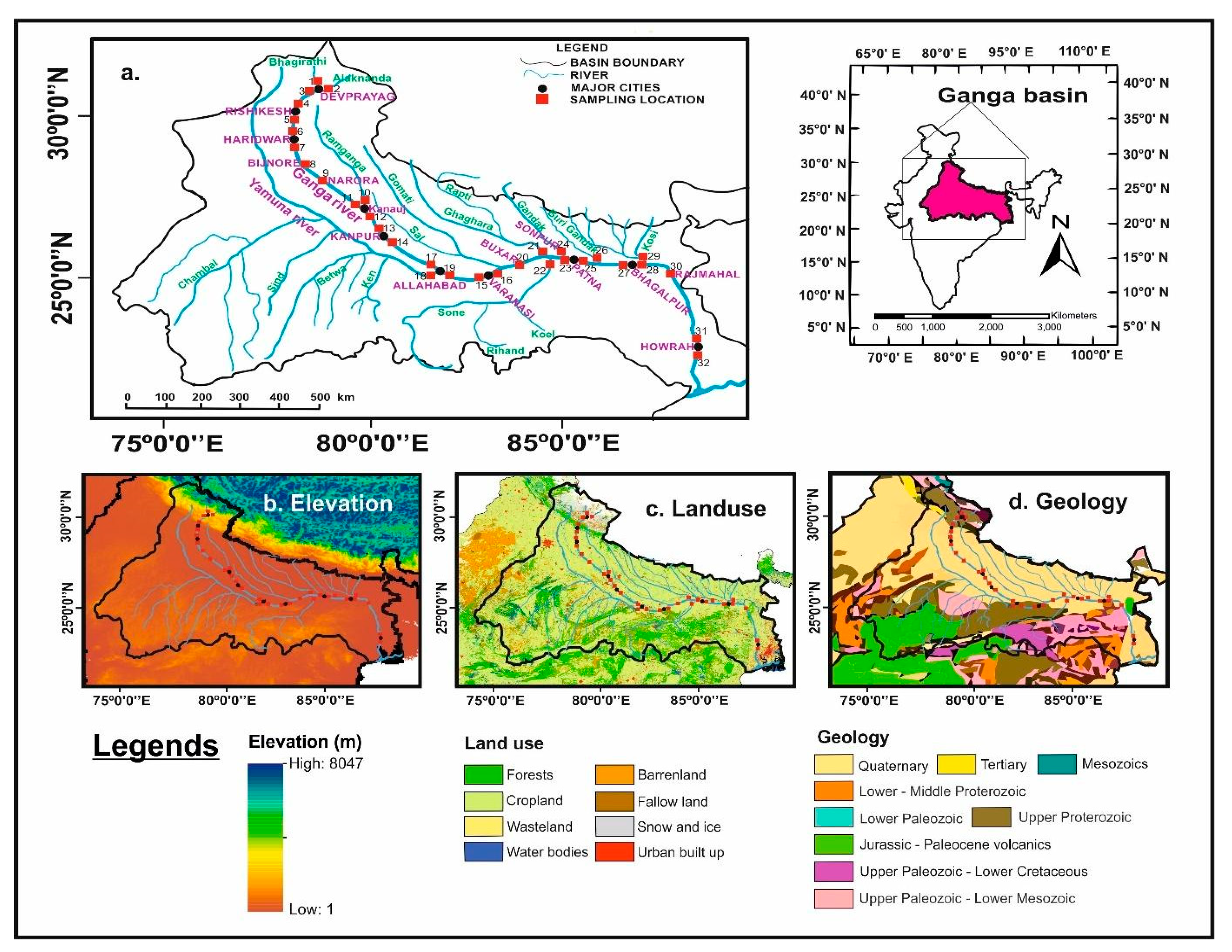
2. Materials and Methods
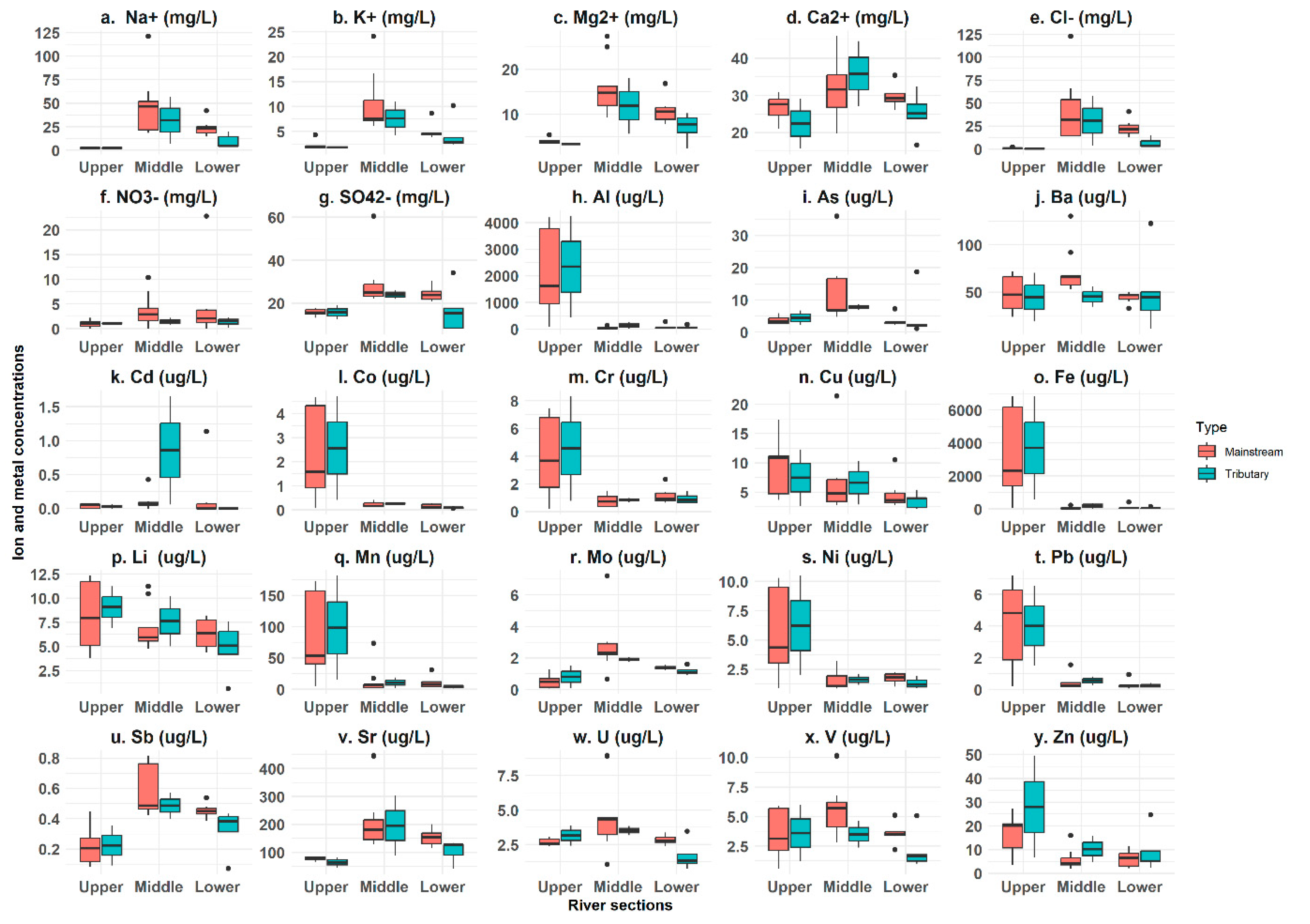
3. Results
4. Discussion
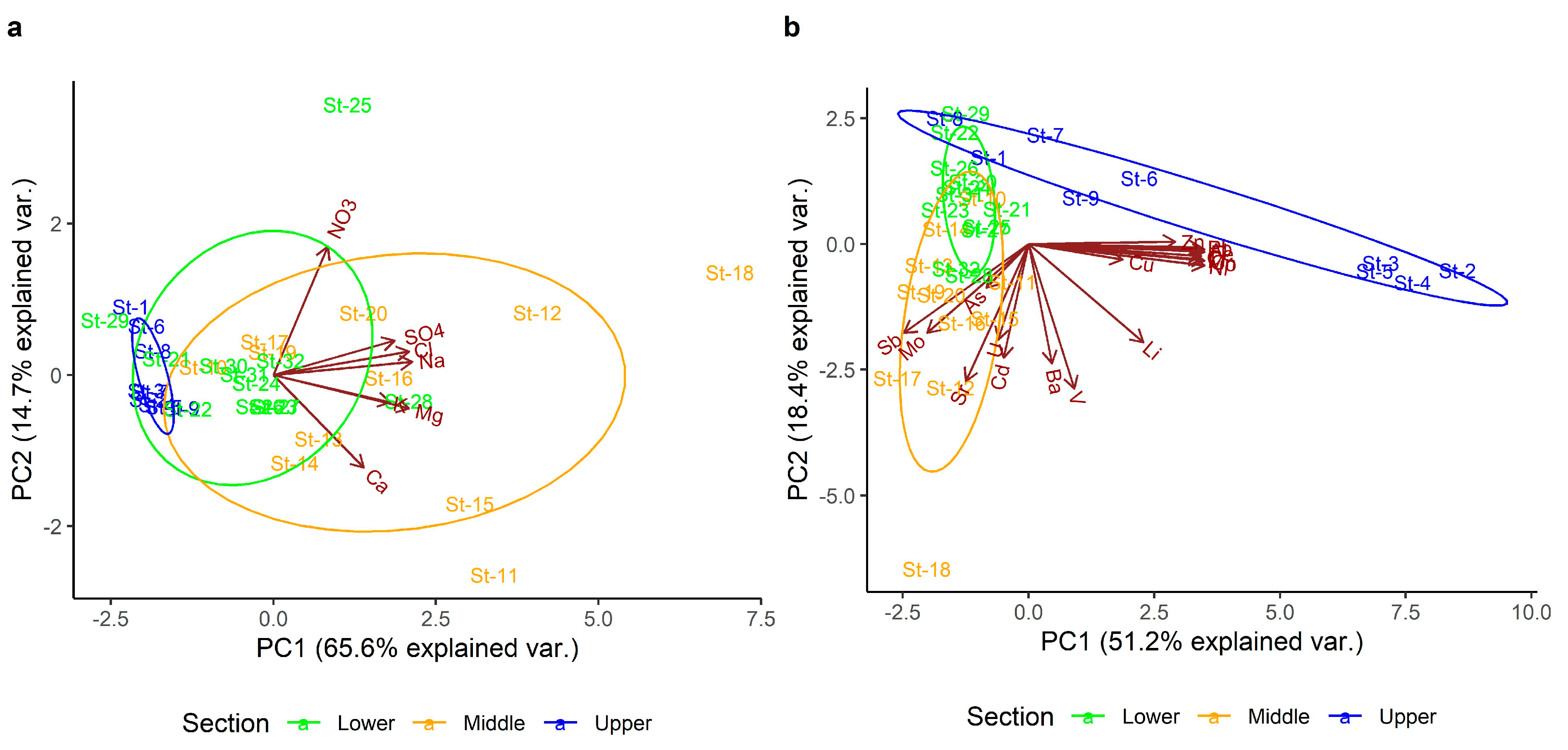
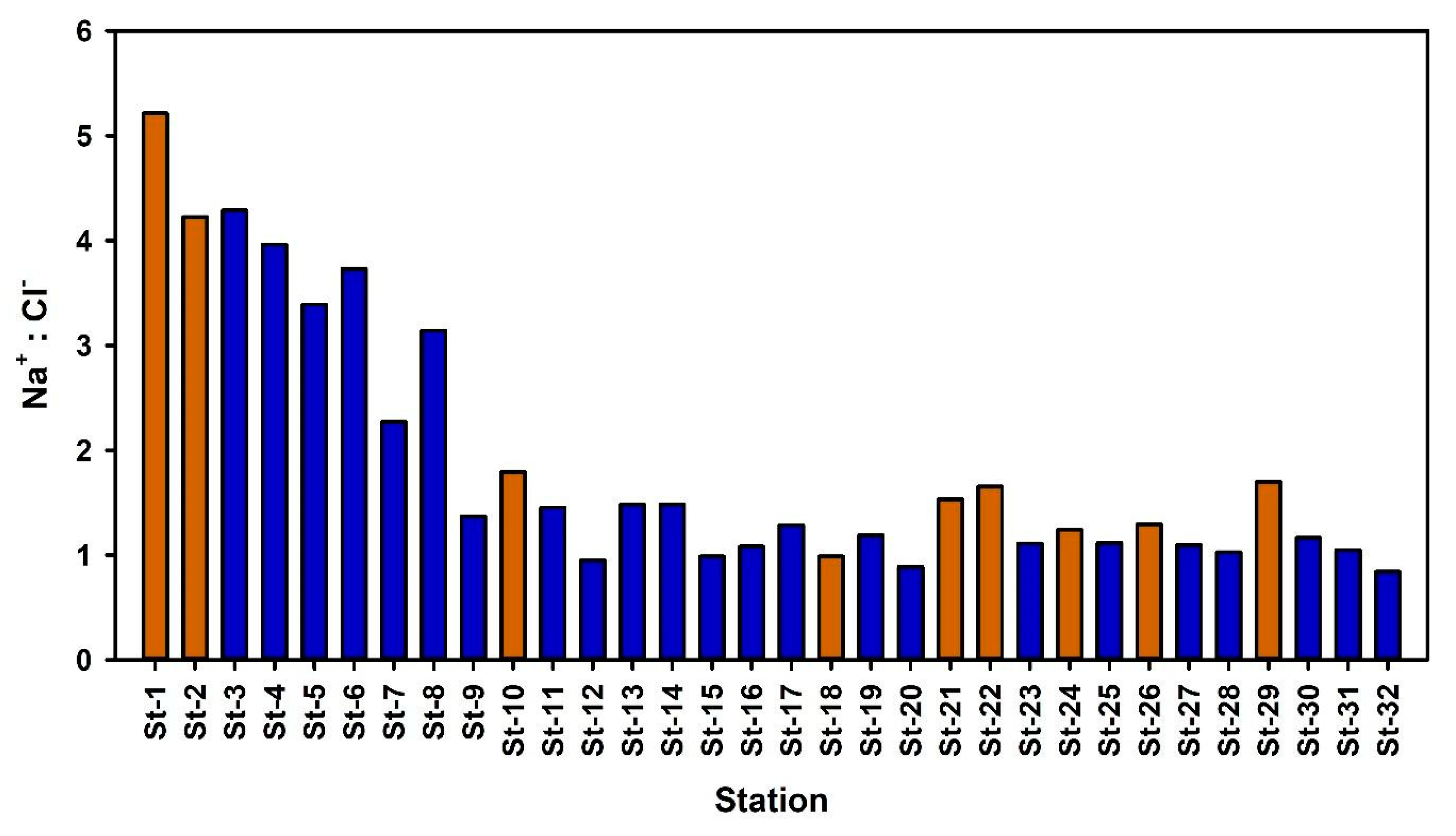
4.1. Major Ions
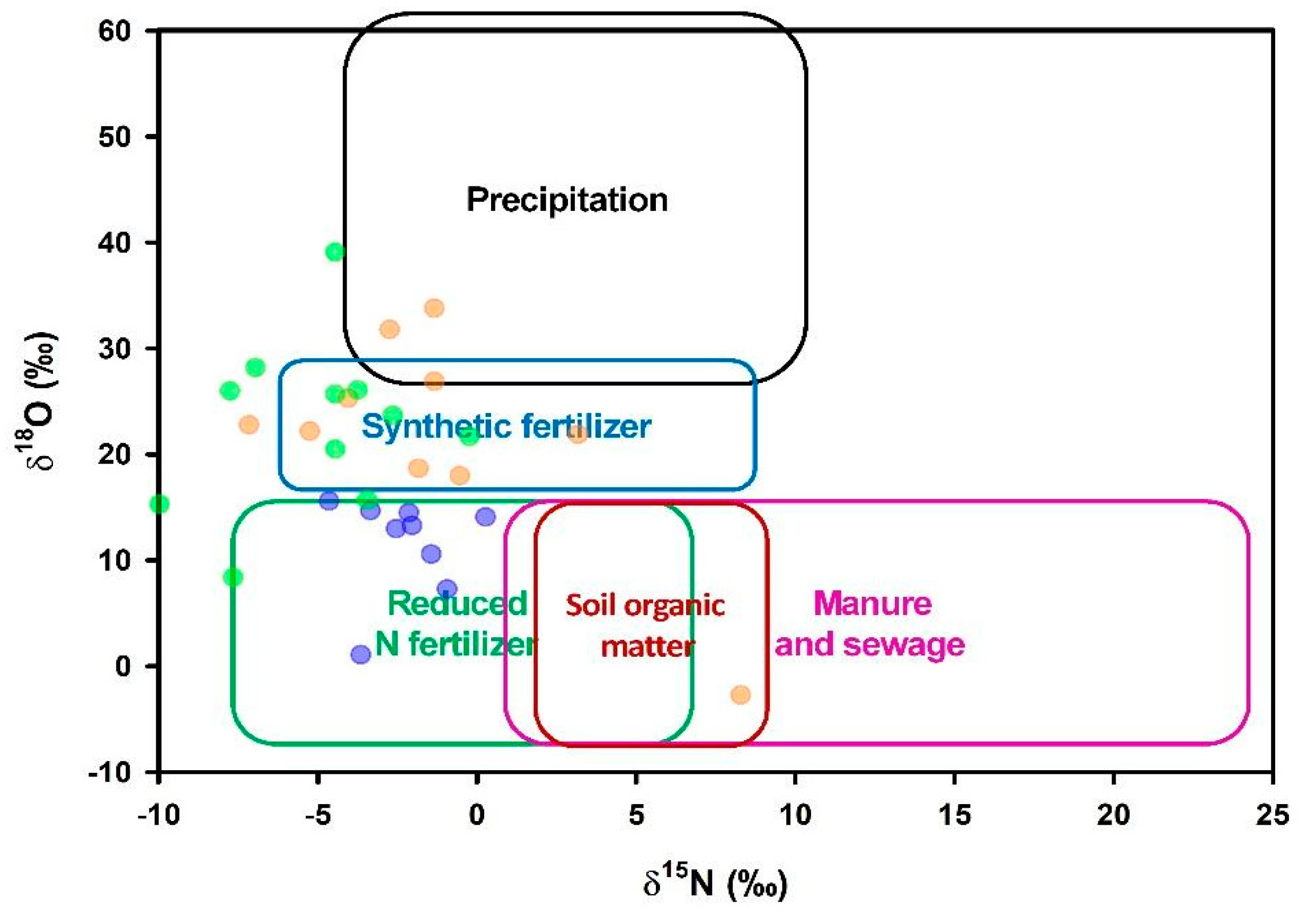
4.2. Nitrate Isotopic Composition
4.3. Metals
4.4. Variability in Metals and Ions along the Basin
5. Conclusions
Supplementary Materials
Author Contributions
Funding
Data Availability Statement
Acknowledgments
Conflicts of Interest
References
- Shukla, A.K.; Ojha, C.S.P.; Shukla, S.; Garg, R.D. Water Quality Challenges in Ganga River Basin, India. In The Ganga River Basin: A Hydrometeorological Approach; Chauhan, M.S., Ojha, C.S.P., Eds.; Society of Earth Scientists Series; Springer International Publishing: Cham, Switzerland, 2021; pp. 1–19. ISBN 978-3-030-60869-9. [Google Scholar]
- Maurya, A.S.; Shah, M.; Deshpande, R.D.; Bhardwaj, R.M.; Prasad, A.; Gupta, S.K. Hydrograph Separation and Precipitation Source Identification Using Stable Water Isotopes and Conductivity: River Ganga at Himalayan Foothills. Hydrol. Process. 2011, 25, 1521–1530. [Google Scholar] [CrossRef]
- Paul, D. Research on Heavy Metal Pollution of River Ganga: A Review. Ann. Agrar. Sci. 2017, 15, 278–286. [Google Scholar] [CrossRef]
- Dwivedi, S.; Mishra, S.; Tripathi, R.D. Ganga Water Pollution: A Potential Health Threat to Inhabitants of Ganga Basin. Environ. Int. 2018, 117, 327–338. [Google Scholar] [CrossRef] [PubMed]
- Pathak, S.S.; Mishra, P. A Review of the Ganga River Water Pollution along Major Urban Centres in the State of Uttar Pradesh, India. Int. Res. J. Eng.Technol. 2020, 7, 1202–1210. [Google Scholar]
- Shah, Z.U.; Parveen, S. Pesticides Pollution and Risk Assessment of River Ganga: A Review. Heliyon 2021, 7, e07726. [Google Scholar] [CrossRef]
- Trivedi, R. Water Quality of the Ganga River–An Overview. Aquat. Ecosyst. Health Manag. 2010, 13, 347–351. [Google Scholar] [CrossRef]
- Trivedi, R.C.; Trivedi, R.C. Water Quality Challenges in Ganga Basin, India. In Our National River Ganga: Lifeline of Millions; Sanghi, R., Ed.; Springer International Publishing: Cham, Switzerland, 2014; pp. 189–210. ISBN 978-3-319-00530-0. [Google Scholar]
- Fuoco, I.; Figoli, A.; Criscuoli, A.; Brozzo, G.; De Rosa, R.; Gabriele, B.; Apollaro, C. Geochemical Modeling of Chromium Release in Natural Waters and Treatment by RO/NF Membrane Processes. Chemosphere 2020, 254, 126696. [Google Scholar] [CrossRef]
- Karunanidhi, D.; Subramani, T.; Roy, P.D.; Li, H. Impact of Groundwater Contamination on Human Health. Environ. Geochem. Health 2021, 43, 643–647. [Google Scholar] [CrossRef]
- Boral, S.; Sen, I.S.; Tripathi, A.; Sharma, B.; Dhar, S. Tracking Dissolved Trace and Heavy Metals in the Ganga River from Source to Sink: A Baseline to Judge Future Changes. Geochem. Geophys. Geosystems 2020, 21, e2020GC009203. [Google Scholar] [CrossRef]
- Ansari, A. Evaluation of Heavy Metal Pollution Index Considering Health Risk in Complete Stretch of Ganga River. Innov. Infrastruct. Solut. 2023, 8, 98. [Google Scholar] [CrossRef]
- Chaudhary, M.; Walker, T.R. River Ganga Pollution: Causes and Failed Management Plans (Correspondence on Dwivedi et al. 2018. Ganga Water Pollution: A Potential Health Threat to Inhabitants of Ganga Basin. Environment International 117, 327–338). Environ. Int. 2019, 126, 202–206. [Google Scholar] [CrossRef] [PubMed]
- Srinivas, R.; Singh, A.P.; Shankar, D. Understanding the Threats and Challenges Concerning Ganges River Basin for Effective Policy Recommendations towards Sustainable Development. Environ. Dev. Sustain. 2020, 22, 3655–3690. [Google Scholar] [CrossRef]
- Radhakrishnan, N.; Taneja, S.; Ambastha, S.; Pipil, H.; Haritash, A.K. Heavy Metal Profile, Mobility, and Source Characterization in Size-Fractionated Bed-Sediments of River Ganga, India. Mar. Pollut. Bull. 2023, 188, 114650. [Google Scholar] [CrossRef] [PubMed]
- Kamboj, N.; Kamboj, V. Water Quality Assessment Using Overall Index of Pollution in Riverbed-Mining Area of Ganga-River Haridwar, India. Water Sci. 2019, 33, 65–74. [Google Scholar] [CrossRef]
- Trombadore, O.; Nandi, I.; Shah, K. Effective Data Convergence, Mapping, and Pollution Categorization of Ghats at Ganga River Front in Varanasi. Environ. Sci. Pollut. Res. 2020, 27, 15912–15924. [Google Scholar] [CrossRef] [PubMed]
- Dimri, D.; Kumar, A.; Mishra, D.K.; Sharma, A. Spatio-Temporal Variation of Trace Elements Distributed over Surface Water of Upper Ganga River Basin in Western Himalayan Region. J. Mt. Sci. 2023, 20, 145–162. [Google Scholar] [CrossRef]
- Richards, L.A.; Fox, B.G.; Bowes, M.J.; Khamis, K.; Kumar, A.; Kumari, R.; Kumar, S.; Hazra, M.; Howard, B.; Thorn, R.M. A Systematic Approach to Understand Hydrogeochemical Dynamics in Large River Systems: Development and Application to the River Ganges (Ganga) in India. Water Res. 2022, 211, 118054. [Google Scholar] [CrossRef]
- Chakrapani, G.J. Major and Trace Element Geochemistry in Upper Ganga River in the Himalayas, India. Environ. Geol. 2005, 48, 189–201. [Google Scholar] [CrossRef]
- Sarin, M.; Krishnaswami, S.; Dilli, K.; Somayajulu, B.; Moore, W. Major Ion Chemistry of the Ganga-Brahmaputra River System: Weathering Processes and Fluxes to the Bay of Bengal. Geochim. Cosmochim. Acta 1989, 53, 997–1009. [Google Scholar] [CrossRef]
- Aravena, R.; Robertson, W.D. Use of Multiple Isotope Tracers to Evaluate Denitrification in Ground Water: Study of Nitrate from a Large-flux Septic System Plume. Groundwater 1998, 36, 975–982. [Google Scholar] [CrossRef]
- Zhang, Y.; Shi, P.; Song, J.; Li, Q. Application of Nitrogen and Oxygen Isotopes for Source and Fate Identification of Nitrate Pollution in Surface Water: A Review. Appl. Sci. 2019, 9, 18. [Google Scholar] [CrossRef]
- Awaleh, M.O.; Boschetti, T.; Adaneh, A.E.; Chirdon, M.A.; Ahmed, M.M.; Dabar, O.A.; Soubaneh, Y.D.; Egueh, N.M.; Kawalieh, A.D.; Kadieh, I.H.; et al. Origin of Nitrate and Sulfate Sources in Volcano-Sedimentary Aquifers of the East Africa Rift System: An Example of the Ali-Sabieh Groundwater (Republic of Djibouti). Sci. Total Environ. 2022, 804, 150072. [Google Scholar] [CrossRef]
- Niu, C.; Zhai, T.; Zhang, Q.; Wang, H.; Xiao, L. Research Advances in the Analysis of Nitrate Pollution Sources in a Freshwater Environment Using Δ15N-NO3− and Δ18O-NO3−. Int. J. Environ. Res. Public Health 2021, 18, 11805. [Google Scholar] [CrossRef]
- Shan, X.; Shi, X.; Clift, P.; Seddique, A.; Liu, S.; Tan, C.; Liu, J.; Sojib, M.R.; Li, J.; Song, Z. Sedimentology of the Modern Seasonal Lower Ganges River with Low Inter-Annual Peak Discharge Variance, Bangladesh. J. Geol. Soc. 2020, 178, jgs2020-094. [Google Scholar] [CrossRef]
- Kar, S.; Ghosh, I.; Chowdhury, P.; Ghosh, A.; Aitch, P.; Bhandari, G.; RoyChowdhury, A. A Model-Based Prediction and Analysis of Seasonal and Tidal Influence on Pollutants Distribution from City Outfalls of River Ganges in West Bengal, India and Its Mapping Using GIS Tool. PLoS Water 2022, 1, e0000008. [Google Scholar] [CrossRef]
- Singh, V.; Nagpoore, N.K.; Lehri, A. Monitoring and Assessment of Pollution Load in Surface Water of River Ganga around Kanpur, India: A Study for Suitability of This Water for Different Uses. Environ. Technol. Innov. 2020, 18, 100676. [Google Scholar] [CrossRef]
- Mukherjee, A.; Bhanja, S.N.; Wada, Y. Groundwater Depletion Causing Reduction of Baseflow Triggering Ganges River Summer Drying. Sci. Rep. 2018, 8, 12049. [Google Scholar] [CrossRef]
- Brown, R.M.; McClelland, N.I.; Deininger, R.A.; O’Connor, M.F. A Water Quality Index—Crashing the Psychological Barrier; Springer: Boston, MA, USA, 1972; pp. 173–182. [Google Scholar]
- Guha, T.; Mahata, S.; Bhattacharya, S.K.; Singh, B.B.; Toyoda, S.; Yoshida, N.; Liang, M. Stratospheric Incursion as a Source of Enhancement of the Isotopic Ratios of Atmospheric N2O at Western Pacific. Earth Space Sci. 2020, 7, e2020EA001102. [Google Scholar] [CrossRef]
- Kaushal, R.; Lai, C.-C.; Shiah, F.-K.; Liang, M.-C. Utilization of Δ17O for Nitrate Dynamics in a Subtropical Freshwater Reservoir. Sci. Total Environ. 2021, 753, 141836. [Google Scholar] [CrossRef]
- McIlvin, M.R.; Altabet, M.A. Chemical Conversion of Nitrate and Nitrite to Nitrous Oxide for Nitrogen and Oxygen Isotopic Analysis in Freshwater and Seawater. Anal. Chem. 2005, 77, 5589–5595. [Google Scholar] [CrossRef]
- Nhantumbo, C.; Larsson, R.; Larson, M.; Juízo, D.; Persson, K.M. A Simplified Model to Estimate the Concentration of Inorganic Ions and Heavy Metals in Rivers. Water 2016, 8, 453. [Google Scholar] [CrossRef]
- Viers, J.; Dupré, B.; Gaillardet, J. Chemical Composition of Suspended Sediments in World Rivers: New Insights from a New Database. Sci. Total Environ. 2009, 407, 853–868. [Google Scholar] [CrossRef] [PubMed]
- Matiatos, I.; Wassenaar, L.I.; Monteiro, L.R.; Venkiteswaran, J.J.; Gooddy, D.C.; Boeckx, P.; Sacchi, E.; Yue, F.-J.; Michalski, G.; Alonso-Hernández, C.; et al. Global Patterns of Nitrate Isotope Composition in Rivers and Adjacent Aquifers Reveal Reactive Nitrogen Cascading. Commun. Earth Environ. 2021, 2, 52. [Google Scholar] [CrossRef]
- Rao, N.S.; Rao, P.S. Major Ion Chemistry of Groundwater in a River Basin: A Study from India. Environ. Earth Sci. 2010, 61, 757–775. [Google Scholar] [CrossRef]
- Khan, M.Y.A.; Panwar, S.; Wen, J. Geochemistry of the Dissolved Load of the Ramganga River, Ganga Basin, India: Anthropogenic Impacts and Chemical Weathering. Front. Environ. Sci. 2022, 10, 823385. [Google Scholar] [CrossRef]
- Malik, D.; Singh, S.; Thakur, J.; Singh, R.K.; Kaur, A.; Nijhawan, S. Heavy Metal Pollution of the Yamuna River: An Introspection. Int. J. Curr. Microbiol. Appl. Sci. 2014, 3, 856–863. [Google Scholar]
- Misra, A. A River about to Die: Yamuna. J. Water Resour. Prot. 2010, 2, 489–500. [Google Scholar] [CrossRef]
- Sharma, M.; Kansal, A.; Jain, S.; Sharma, P. Application of Multivariate Statistical Techniques in Determining the Spatial Temporal Water Quality Variation of Ganga and Yamuna Rivers Present in Uttarakhand State, India. Water Qual. Expo. Health 2015, 7, 567–581. [Google Scholar] [CrossRef]
- Sharma, P.; Meher, P.K.; Kumar, A.; Gautam, Y.P.; Mishra, K.P. Changes in Water Quality Index of Ganges River at Different Locations in Allahabad. Sustain. Water Qual. Ecol. 2014, 3, 67–76. [Google Scholar] [CrossRef]
- Williams, M.; Hopkinson, C.; Rastetter, E.; Vallino, J.; Claessens, L. Relationships of Land Use and Stream Solute Concentrations in the Ipswich River Basin, Northeastern Massachusetts. Water Air Soil Pollut. 2005, 161, 55–74. [Google Scholar] [CrossRef]
- Rai, S.K.; Singh, S.K.; Krishnaswami, S. Chemical Weathering in the Plain and Peninsular Sub-Basins of the Ganga: Impact on Major Ion Chemistry and Elemental Fluxes. Geochim. Cosmochim. Acta 2010, 74, 2340–2355. [Google Scholar] [CrossRef]
- Yue, F.-J.; Li, S.-L.; Liu, C.-Q.; Zhao, Z.-Q.; Ding, H. Tracing Nitrate Sources with Dual Isotopes and Long Term Monitoring of Nitrogen Species in the Yellow River, China. Sci. Rep. 2017, 7, 8537. [Google Scholar] [CrossRef] [PubMed]
- Bhattacharjee, R.; Gupta, A.; Das, N.; Agnihotri, A.K.; Ohri, A.; Gaur, S. Analysis of Algal Bloom Intensification in Mid-Ganga River, India, Using Satellite Data and Neural Network Techniques. Environ. Monit. Assess. 2022, 194, 547. [Google Scholar] [CrossRef] [PubMed]
- Briand, C.; Sebilo, M.; Louvat, P.; Chesnot, T.; Vaury, V.; Schneider, M.; Plagnes, V. Legacy of Contaminant N Sources to the NO3− Signature in Rivers: A Combined Isotopic (Δ15N-NO3−, Δ18O-NO3−, Δ11B) and Microbiological Investigation. Sci. Rep. 2017, 7, 41703. [Google Scholar] [CrossRef] [PubMed]
- Popescu, R.; Mimmo, T.; Dinca, O.R.; Capici, C.; Costinel, D.; Sandru, C.; Ionete, R.E.; Stefanescu, I.; Axente, D. Using Stable Isotopes in Tracing Contaminant Sources in an Industrial Area: A Case Study on the Hydrological Basin of the Olt River, Romania. Sci. Total Environ. 2015, 533, 17–23. [Google Scholar] [CrossRef] [PubMed]
- Santy, S.; Mujumdar, P.; Bala, G. Potential Impacts of Climate and Land Use Change on the Water Quality of Ganga River around the Industrialized Kanpur Region. Sci. Rep. 2020, 10, 9107. [Google Scholar] [CrossRef] [PubMed]
- Gupta, P.K.; Yadav, B.; Le Corre, K.; Parker, A. Chapter 17—Nitrate-N Movement Revealed by a Controlled in Situ Solute Injection Experiment in the Middle Gangetic Plains of India. In Advances in Remediation Techniques for Polluted Soils and Groundwater; Gupta, P.K., Yadav, B., Himanshu, S.K., Eds.; Elsevier: Amsterdam, The Netherlands, 2022; pp. 319–335. ISBN 978-0-12-823830-1. [Google Scholar]
- Mallick, S.; Banerji, S. Nitrate Pollution of Ground Water as Result of Agricultural Development in Indo-Ganga Plain, India. In Studies in Environmental Science; Van Duijvenbooden, W., Glasbergen, P., Van Lelyveld, H., Eds.; Quality of Groundwater; Elsevier: Amsterdam, The Netherlands, 1981; Volume 17, pp. 155–162. [Google Scholar]
- Kumar, A.; Ajay, A.; Dasgupta, B.; Bhadury, P.; Sanyal, P. Deciphering the Nitrate Sources and Processes in the Ganga River Using Dual Isotopes of Nitrate and Bayesian Mixing Model. Environ. Res. 2023, 216, 114744. [Google Scholar] [CrossRef]
- Beman, J.M.; Arrigo, K.R.; Matson, P.A. Agricultural Runoff Fuels Large Phytoplankton Blooms in Vulnerable Areas of the Ocean. Nature 2005, 434, 211–214. [Google Scholar] [CrossRef]
- Ramesh, R.; Paneer Selvam, A.; Robin, R.S.; Ganguly, D.; Singh, G.; Purvaja, R. Nitrogen Assessment in Indian Coastal Systems. In The Indian Nitrogen Assessment; Abrol, Y.P., Adhya, T.K., Aneja, V.P., Raghuram, N., Pathak, H., Kulshrestha, U., Sharma, C., Singh, B., Eds.; Elsevier: Amsterdam, The Netherlands, 2017; pp. 361–379. ISBN 978-0-12-811836-8. [Google Scholar]
- Maurya, P.K.; Malik, D.S.; Yadav, K.K.; Kumar, A.; Kumar, S.; Kamyab, H. Bioaccumulation and Potential Sources of Heavy Metal Contamination in Fish Species in River Ganga Basin: Possible Human Health Risks Evaluation. Toxicol. Rep. 2019, 6, 472–481. [Google Scholar] [CrossRef]
- Singh, M.; Ansari, A.A.; Müller, G.; Singh, I.B. Heavy Metals in Freshly Deposited Sediments of the Gomati River (a Tributary of the Ganga River): Effects of Human Activities. Environ. Geol. 1997, 29, 246–252. [Google Scholar] [CrossRef]
- Pandey, J.; Singh, R. Heavy Metals in Sediments of Ganga River: Up-and Downstream Urban Influences. Appl. Water Sci. 2017, 7, 1669–1678. [Google Scholar] [CrossRef]
- Singh, S.; Dalai, T.K.; Krishnaswami, S. 238U Series Isotopes and 232Th in Carbonates and Black Shales from the Lesser Himalaya: Implications to Dissolved Uranium Abundances in Ganga-Indus Source Waters. J. Environ. Radioact. 2003, 67, 69–90. [Google Scholar] [CrossRef]
- Lupker, M.; France-Lanord, C.; Galy, V.; Lavé, J.; Kudrass, H. Increasing Chemical Weathering in the Himalayan System since the Last Glacial Maximum. Earth Planet. Sci. Lett. 2013, 365, 243–252. [Google Scholar] [CrossRef]
- Purushothaman, P.; Chakrapani, G.J. Heavy Metals Fractionation in Ganga River Sediments, India. Environ. Monit. Assess. 2007, 132, 475–489. [Google Scholar] [CrossRef] [PubMed]
- Chakrapani, G.J.; Saini, R.K.; Yadav, S.K. Chemical Weathering Rates in the Alaknanda–Bhagirathi River Basins in Himalayas, India. J. Asian Earth Sci. 2009, 34, 347–362. [Google Scholar] [CrossRef]
- Alarcón-Herrera, M.T.; Gutiérrez, M. Geogenic Arsenic in Groundwater: Challenges, Gaps, and Future Directions. Curr. Opin. Environ. Sci. Health 2022, 27, 100349. [Google Scholar] [CrossRef]
- Deepali, K. Gangwar Metals Concentration in Textile and Tannery Effluents, Associated Soils and Ground Water. N. Y. Sci. J. 2009, 3, 82–89. [Google Scholar]
- Katiyar, S. Impact of Tannery Effluent with Special Reference to Seasonal Variation on Physico-Chemical Characteristics of River Water at Kanpur (U.P), India. J. Environ. Anal. Toxicol. 2011, 1, 117. [Google Scholar] [CrossRef]
- Laskar, A.H.; Saranya, P.; Liang, M.-C.; Sahu, L.; Nityanand, S.M.; Maurya, A.S. Water Dynamics of the Ganga River in Summer: Evaporation, Interaction with Groundwated, Base Flow Reduction and Rejuvenation; 2023; to be submitted. [Google Scholar]
- Das, P.; Mukherjee, A.; Hussain, S.A.; Jamal, M.S.; Das, K.; Shaw, A.; Layek, M.K.; Sengupta, P. Stable Isotope Dynamics of Groundwater Interactions with Ganges River. Hydrol. Process. 2021, 35, e14002. [Google Scholar] [CrossRef]
- CPCB. Pollution Assessment: River Ganga; Central Pollution Control Board, Ministry of Environment and Forests, Government of India: New Delhi, India, 2013. [Google Scholar]
- Wen, Y.; Schoups, G.; Van de Giesen, N. Organic Pollution of Rivers: Combined Threats of Urbanization, Livestock Farming and Global Climate Change. Sci. Rep. 2017, 7, 43289. [Google Scholar] [CrossRef]
- Apollaro, C.; Tripodi, V.; Vespasiano, G.; De Rosa, R.; Dotsika, E.; Fuoco, I.; Critelli, S.; Muto, F. Chemical, Isotopic and Geotectonic Relations of the Warm and Cold Waters of the Galatro and Antonimina Thermal Areas, Southern Calabria, Italy. Mar. Pet. Geol. 2019, 109, 469–483. [Google Scholar] [CrossRef]


| Station | Section | Date | Type | Nearby City | pH | Temp (°C) | Conductivity (μS/cm) |
|---|---|---|---|---|---|---|---|
| St-1 | Upper | 3 June 2019 | Tributary (Bhagirathi) | Devprayag | 8.7 | 19.1 | 120 |
| St-2 | 3 June 2019 | Tributary (Alaknanda) | Devprayag | 8.7 | 17.9 | 130 | |
| St-3 | 3 June 2019 | Mainstream Ganges | Devprayag | 8.8 | 18.1 | 130 | |
| St-4 | 3 June 2019 | Mainstream Ganges | Rishikesh | 8.8 | 18.3 | 140 | |
| St-5 | 3 June 2019 | Mainstream Ganges | Rishikesh | 8.9 | 19.8 | 140 | |
| St-6 | 3 June 2019 | Mainstream Ganges | Haridwar | 9 | 20.5 | 150 | |
| St-7 | 3 June 2019 | Mainstream Ganges | Haridwar | 9 | 23 | 160 | |
| St-8 | 4 June 2019 | Mainstream Ganges | Bijnore | 9 | 26.2 | 160 | |
| St-9 | 9 June 2019 | Mainstream Ganges | Narora | 9 | 28.5 | 170 | |
| St-10 | Middle | 8 June 2019 | Tributary (Ramganga) | Kannauj | 9.8 | 30.2 | 190 |
| St-11 | 8 June 2019 | Mainstream Ganges | Kannauj | 10.1 | 31.2 | 500 | |
| St-12 | 8 June 2019 | Mainstream Ganges | Kannauj | 10 | 32.5 | 350 | |
| St-13 | 7 June 2019 | Mainstream Ganges | Kanpur | 9.7 | 32.6 | 320 | |
| St-14 | 7 June 2019 | Mainstream Ganges | Kanpur | 9.7 | 32.8 | 330 | |
| St-15 | 25 June 2019 | Mainstream Ganges | Varanasi | 7.8 | 34 | 618 | |
| St-16 | 24 June 2019 | Mainstream Ganges | Varanasi | 8.4 | 30.3 | 458 | |
| St-17 | 22 June 2019 | Mainstream Ganges | Allahabad | 9.2 | 31 | 279 | |
| St-18 | 22 June 2019 | Tributary (Yamuna) | Allahabad | 9.1 | 32.2 | 794 | |
| St-19 | 22 June 2019 | Mainstream Ganges | Allahabad | 9.15 | 32.9 | 293 | |
| St-20 | 21 June 2019 | Mainstream Ganges | Buxar | 8.4 | 32.1 | 435 | |
| St-21 | Lower | 27 June 2019 | Tributary (Ghaghra) | Chapra | 8.5 | 32.2 | 184.6 |
| St-22 | 11 June 2019 | Tributary (Sone) | Chapra | 7.9 | -NA- | -NA- | |
| St-23 | 11 June 2019 | Mainstream Ganges | Patna | 8.6 | -NA- | -NA- | |
| St-24 | 11 June 2019 | Tributary (Gandak) | Patna | 8.4 | -NA- | -NA- | |
| St-25 | 10 June 2019 | Mainstream Ganges | Patna | 8.7 | -NA- | -NA- | |
| St-26 | 28 June 2019 | Tributary (Buri Gandak) | 8.8 | 35.1 | 296 | ||
| St-27 | 13 June 2019 | Mainstream Ganges | Bhagalpur | 9.2 | 31.2 | 470 | |
| St-28 | 13 June 2019 | Mainstream Ganges | Bhagalpur | 8.75 | 31.2 | 315 | |
| St-29 | 13 June 2019 | Tributary (Kosi) | 8.56 | 31.2 | 119.8 | ||
| St-30 | 14 June 2019 | Mainstream Ganges | Rajmahal | 8.5 | 30.9 | 252 | |
| St-31 | 16 June 2019 | Mainstream Ganges | Howrah | 8.2 | 30.8 | 281 | |
| St-32 | 15 June 2019 | Mainstream Ganges | Howrah | 8.15 | 31.6 | 334 |
| Present Study | WHO 2006 | Global River Average * | ||||
|---|---|---|---|---|---|---|
| Range (Min-Max) | Upper Section (µ ± σ) | Middle Section (µ ± σ) | Lower Section (µ ± σ) | |||
| Na+ (mg/L) | 1.6–121.2 | 2.5 ± 0.7 b | 43.4 ±31.7 a | 17.9 ± 10.9 b | 200 | 6.93 |
| K+ (mg/L) | 1.5–24.1 | 2.10 ± 0.87 b | 10.0 ± 5.8 a | 4.74 ± 2.36 b | 200 | 1.62 |
| Mg2+ (mg/L) | 2.3–27.4 | 3.81 ± 0.66 c | 15.1 ± 6.6 a | 9.26 ± 3.50 b | 600 | 4.03 |
| Ca2+ (mg/L) | 15.6–45.9 | 25.7 ± 4.9 | 32.6 ± 8.0 | 27.8 ± 4.7 | 600 | 15.68 |
| Cl− (mg/L) | 0.4–122.8 | 0.88 ± 0.59 b | 40.6 ± 34.5 a | 16.2 ± 11.4 b | 250 | 8.43 |
| NO3− (mg/L) | 0–22.8 | 1.02 ± 0.71 | 3.11 ± 3.22 | 3.48 ± 6.20 | 50 | 1.16 |
| SO42− (mg/L) | 8.2–60.5 | 15.9 ± 2.1 b | 28.6 ± 11.0 a | 21.13 ± 7.83 a/b | 250 | 12.22 |
| Al (µg/L) | 17–4246 | 2222 ± 1740 a | 63 ± 71 b | 83 ± 74 b | 200 | 32 |
| As (µg/L) | 1.1–36.0 | 3.82 ± 1.62 b | 11.9 ± 9.2 a | 4.15 ± 4.83 b | 10 | 0.62 |
| Ba (µg/L) | 11.4–130.5 | 3.8 ± 1.6 | 11.9 ± 9.2 | 4.2 ± 4.8 | 700 | 23.00 |
| Cd (µg/L) | 0–1.66 | 0.04 ± 0.04 | 0.24 ± 0.49 | 0.11 ± 0.33 | 3 | 0.08 |
| Co | 0.06–4.74 | 2.44 ± 2.02 a | 0.23 ± 0.10 b | 0.13 ± 0.08 b | -- | 0.15 |
| Cr (µg/L) | 0.2–8.3 | 4.17 ± 3.19 a | 0.78 ± 0.37 b | 1.07 ± 0.49 b | 50 | 0.70 |
| Cu (µg/L) | 2.2–21.4 | 8.73 ± 5.01 | 6.57 ± 5.45 | 4.23 ± 2.23 | 2000 | 1.48 |
| Fe (µg/L) | 21–6851 | 3531 ± 2897 a | 84 ± 109 b | 89 ± 105 b | 300 | 66 |
| Li (µg/L) | 0.7–12.3 | 8.4 ± 3.4 | 7.0 ± 2.4 | 5.7 ± 2.1 | -- | 1.84 |
| Mn (µg/L) | 1.2–181.3 | 91.4 ± 73.9 a | 12.9 ± 20.9 b | 8.10 ± 7.99 b | 400 | 34 |
| Mo (µg/L) | 0.1–7.2 | 0.6 ± 0.5 b | 2.6 ± 1.6 a | 1.3 ± 0.2 b | -- | 0.42 |
| Ni (µg/L) | 0.87–10.5 | 5.90 ± 3.96 a | 1.54 ± 0.74 b | 1.58 ± 0.47 b | 70 | 0.80 |
| Pb (µg/L) | 0.07–7.17 | 4.05 ± 2.70 a | 0.45 ± 0.42 b | 0.28 ± 0.23 b | 10 | 0.08 |
| Sb (µg/L) | 0.1–0.8 | 0.2 ± 0.1 c | 0.6 ± 0.2 a | 0.4 ± 0.1 b | 20 | 0.07 |
| Sr (µg/L) | 42–444 | 75 ± 13 b | 204 ± 100 a | 133 ± 41 a/b | -- | 60.0 |
| U (µg/L) | 0.8–8.9 | 2.8 ± 0.5 | 4.0 ± 1.9 a | 2.4 ± 0.9 b | 30 | 0.37 |
| V (µg/L) | 0.6–10.1 | 3.6 ± 2.2 | 5.2 ± 2.1 a | 3.0 ± 1.4 b | -- | 0.71 |
| Zn (µg/L) | 2.0–49.4 | 18.9 ± 13.9 a | 6.66 ± 4.95 b | 7.51 ± 6.20 b | 3000 | 0.60 |
| Station | Type | Nearby City | WQI | Status | Uses |
|---|---|---|---|---|---|
| St-1 # | Tributary (Bhagirathi) | Devprayag | 29.16 | Slightly polluted | Drinking, irrigation, industrial |
| St-2 | Tributary (Alaknanda) | Devprayag | 50.91 | Moderately polluted | Irrigation, industrial |
| St-3 | Mainstream Ganges | Devprayag | 48.10 | Slightly polluted | Drinking, irrigation, industrial |
| St-4 | Mainstream Ganges | Rishikesh | 52.88 | Moderately polluted | Irrigation, industrial |
| St-5 | Mainstream Ganges | Rishikesh | 52.30 | Moderately polluted | Irrigation, industrial |
| St-6 | Mainstream Ganges | Haridwar | 39.36 | Slightly polluted | Drinking, irrigation, industrial |
| St-7 #& | Mainstream Ganges | Haridwar | 30.34 | Slightly polluted | Drinking, irrigation, industrial |
| St-8 # | Mainstream Ganges | Bijnore | 25.51 | Slightly polluted | Drinking, irrigation, industrial |
| St-9 & | Mainstream Ganges | Narora | 35.75 | Slightly polluted | Drinking, irrigation, industrial |
| St-10 | Tributary (Ramganga) | Kannauj | 39.13 | Slightly polluted | Drinking, irrigation, industrial |
| St-11 & | Mainstream Ganges | Kannauj | 77.11 | Polluted | Irrigation |
| St-12 | Mainstream Ganges | Kannauj | 53.47 | Moderately polluted | Irrigation, industrial |
| St-13 # | Mainstream Ganges | Kanpur | 47.79 | Slightly polluted | Drinking, irrigation, industrial |
| St-14 #& | Mainstream Ganges | Kanpur | 45.45 | Slightly polluted | Drinking, irrigation, industrial |
| St-15 | Mainstream Ganges | Varanasi | 16.69 | Excellent | Drinking, irrigation, industrial |
| St-16 | Mainstream Ganges | Varanasi | 29.11 | Slightly polluted | Drinking, irrigation, industrial |
| St-17 | Mainstream Ganges | Allahabad | 32.56 | Slightly polluted | Drinking, irrigation, industrial |
| St-18 | Tributary (Yamuna) | Allahabad | 56.26 | Moderately polluted | Irrigation, industrial |
| St-19 | Mainstream Ganges | Allahabad | 32.38 | Slightly polluted | Drinking, irrigation, industrial |
| St-20 | Mainstream Ganges | Buxar | 23.69 | Excellent | Drinking, irrigation, industrial |
| St-21 # | Tributary (Ghaghra) | Chapra | 18.08 | Excellent | Drinking, irrigation, industrial |
| St-22 #$ | Tributary (Sone) | Chapra | 39.75 | Slightly polluted | Drinking, irrigation, industrial |
| St-23 #&$ | Mainstream Ganges | Patna | 19.86 | Excellent | Drinking, irrigation, industrial |
| St-24 #$ | Tributary (Gandak) | Patna | 17.61 | Excellent | Drinking, irrigation, industrial |
| St-25 $ | Mainstream Ganges | Patna | 24.79 | Excellent | Drinking, irrigation, industrial |
| St-26# | Tributary (Buri Gandak) | 41.11 | Slightly polluted | Drinking, irrigation, industrial | |
| St-27 # | Mainstream Ganges | Bhagalpur | 27.29 | Slightly polluted | Drinking, irrigation, industrial |
| St-28 # | Mainstream Ganges | Bhagalpur | 27.44 | Slightly polluted | Drinking, irrigation, industrial |
| St-29 # | Tributary (Kosi) | 19.19 | Excellent | Drinking, irrigation, industrial | |
| St-30 | Mainstream Ganges | Rajmahal | 18.59 | Excellent | Drinking, irrigation, industrial |
| St-31 | Mainstream Ganges | Howrah | 16.84 | Excellent | Drinking, irrigation, industrial |
| St-32 | Mainstream Ganges | Howrah | 31.62 | Slightly polluted | Drinking, irrigation, industrial |
| River | Length (km) | Basin Area (105 km2) | NO3 – (mg/L) | δ15N-NO3 (‰) | δ18O-NO3 (‰) | Sample Number |
|---|---|---|---|---|---|---|
| Mississippi River | 6020 | 32.2 | 1.45 ± 0.5 | 7.7 ± 0.3 | 4.6 ± 0.3 | 22 |
| Yellow River | 5465 | 7.95 | 3.4 ± 0.86 | 8.4 ± 1.1 | 1.2 ± 1.3 | 25 |
| Saint Lawrence River | 1287 | 3.00 | 0.43 ± 0.08 | 5.7 ± 0.7 | 5.4 ± 1.4 | 41 |
| Rhine River | 1320 | 1.85 | 2.7 ± 0.7 | 8.2 | 0.4 | 24 |
| Elbe River | 1165 | 1.48 | 2.6 ± 1.4 | 8.5 | 1.3 | 16 |
| Ganges (present work) | 2525 | 17.3 | 3.16 ± 4.49 | −1.8 ± 3.6 | 18.2 ± 8.2 | 32 |
Disclaimer/Publisher’s Note: The statements, opinions and data contained in all publications are solely those of the individual author(s) and contributor(s) and not of MDPI and/or the editor(s). MDPI and/or the editor(s) disclaim responsibility for any injury to people or property resulting from any ideas, methods, instructions or products referred to in the content. |
© 2023 by the authors. Licensee MDPI, Basel, Switzerland. This article is an open access article distributed under the terms and conditions of the Creative Commons Attribution (CC BY) license (https://creativecommons.org/licenses/by/4.0/).
Share and Cite
Sharma, N.; Liang, M.-C.; Laskar, A.H.; Huang, K.-F.; Maurya, N.S.; Singh, V.; Ranjan, R.; Maurya, A.S. Basin-Scale Geochemical Assessment of Water Quality in the Ganges River during the Dry Season. Water 2023, 15, 2026. https://doi.org/10.3390/w15112026
Sharma N, Liang M-C, Laskar AH, Huang K-F, Maurya NS, Singh V, Ranjan R, Maurya AS. Basin-Scale Geochemical Assessment of Water Quality in the Ganges River during the Dry Season. Water. 2023; 15(11):2026. https://doi.org/10.3390/w15112026
Chicago/Turabian StyleSharma, Niharika, Mao-Chang Liang, Amzad Hussain Laskar, Kuo-Fang Huang, Nityanand Singh Maurya, Vikram Singh, Ritesh Ranjan, and Abhayanand Singh Maurya. 2023. "Basin-Scale Geochemical Assessment of Water Quality in the Ganges River during the Dry Season" Water 15, no. 11: 2026. https://doi.org/10.3390/w15112026