Next Issue
Volume 9, July
Previous Issue
Volume 9, May


Atmosphere, Volume 9, Issue 6 (June 2018) – 34 articles

Cover Story (view full-size image): 
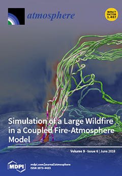
The Aullene fire (23 July 2009) burned more than 3000 ha of forest, of which 2000 ha during the first afternoon. This study explores by simulation the strong fire–atmosphere interactions leading to intense updrafts extending above the boundary layer and horizontal wind speeds feeding the fire. Simulation of such scenarios involves reproducing processes that scale from the flames to the larger regional smoke transport, requiring the use of a coupled fire–atmosphere model. View this paper.
  • Issues are regarded as officially published after their release is announced to the table of contents alert mailing list.
  • You may sign up for e-mail alerts to receive table of contents of newly released issues.
  • PDF is the official format for papers published in both, html and pdf forms. To view the papers in pdf format, click on the "PDF Full-text" link, and use the free Adobe Reader to open them.
Order results
Result details
Section
Select all
Export citation of selected articles as:
12 pages, 12643 KiB  
Article
An Ensemble Mean and Evaluation of Third Generation Global Climate Reanalysis Models
by Jeffrey D. Auger, Sean D. Birkel, Kirk A. Maasch, Paul A. Mayewski and Keah C. Schuenemann
Atmosphere 2018, 9(6), 236; https://doi.org/10.3390/atmos9060236 - 19 Jun 2018
Cited by 13 | Viewed by 4395
Abstract
We have produced a global ensemble mean of the four third-generation climate reanalysis models for the years 1981–2010. The reanalysis system models used in this study are National Centers for Environmental Prediction (NCEP) Climate Forecast System Reanalysis (CFSR), European Centre for Medium-Range Weather [...] Read more.
We have produced a global ensemble mean of the four third-generation climate reanalysis models for the years 1981–2010. The reanalysis system models used in this study are National Centers for Environmental Prediction (NCEP) Climate Forecast System Reanalysis (CFSR), European Centre for Medium-Range Weather Forecasts (ECMWF) Reanalysis Interim (ERA-I), Japan Meteorological Agency (JMA) 55-year Reanalysis (JRA-55), and National Aeronautics and Space Administration (NASA) Modern-Era Retrospective Analysis for Research and Applications (MERRA). Two gridded datasets are used as a baseline, for temperature the Global Historical Climatology Network (GHCN), and for precipitation the Global Precipitation Climatology Centre (GPCC). The reanalysis ensemble mean is used here as a comparison tool of the four reanalysis members. Meteorological fields investigated within the reanalysis models include 2-m air temperature, precipitation, and 500-hPa geopotential heights. Comparing the individual reanalysis models to the ensemble mean, we find that each perform similarly over large domains but exhibit significant differences over particular regions. Full article
(This article belongs to the Special Issue Precipitation: Measurement and Modeling)
Show Figures

Figure 1

17 pages, 8697 KiB  
Article
East Asian Summer Monsoon Representation in Re-Analysis Datasets
by Bo Huang, Ulrich Cubasch and Yan Li
Atmosphere 2018, 9(6), 235; https://doi.org/10.3390/atmos9060235 - 16 Jun 2018
Cited by 6 | Viewed by 4736
Abstract
Eight current re-analyses—NCEP/NCAR Re-analysis (NCEPI), NCEP/DOE Re-analysis (NCEPII), NCEP Climate Forecast System Re-analysis (CFSR), ECMWF Interim Re-analysis (ERA-Interim), Japanese 55-year Re-analysis (JRA-55), NASA Modern-Era Retrospective Analysis for Research and Applications (MERRA), NOAA Twentieth Century Re-analysis (20CR), and ECMWF’s first atmospheric re-analysis of the [...] Read more.
Eight current re-analyses—NCEP/NCAR Re-analysis (NCEPI), NCEP/DOE Re-analysis (NCEPII), NCEP Climate Forecast System Re-analysis (CFSR), ECMWF Interim Re-analysis (ERA-Interim), Japanese 55-year Re-analysis (JRA-55), NASA Modern-Era Retrospective Analysis for Research and Applications (MERRA), NOAA Twentieth Century Re-analysis (20CR), and ECMWF’s first atmospheric re-analysis of the 20th century (ERA-20C)—are assessed to clarify their quality in capturing the East Asian summer monsoon (EASM) rainfall structure and its associated general circulation. They are found to present similar rainfall structures in East Asia, whereas they illustrate some differences in rainfall intensity, especially at lower latitudes. The third generation of re-analysis shows a better estimate of rainfall structure than that in the first and extended generation of re-analysis. Given the fact that the rainfall is ingested by the data assimilation system, the re-analysis cannot improve its production of rainfall quality. The mean sea level pressure is generated by re-analysis, showing a significant uncertainty over the Tibetan Plateau and its surrounding area. In that region, the JRA-55 and MERRA have a negative bias (BIAS), while the other six re-analyses present a positive BIAS to the observed mean sea level pressure. The 20CR and the ERA-20C are ancillary datasets to analyse the EASM due to the fact that they only apply limit observations into the data assimilation system. These two re-analyses demonstrate a prominent difference from the observed winds in the upper-air. Although the upper level winds exhibit difference, the EASM index is consistent in the eight re-analyses, which are based upon the zonal wind over 850 hPa. Full article
(This article belongs to the Special Issue Precipitation: Measurement and Modeling)
Show Figures

Figure 1

16 pages, 3104 KiB  
Article
A Velocity Dealiasing Algorithm on Frequency Diversity Pulse-Pair for Future Geostationary Spaceborne Doppler Weather Radar
by Xuehua Li, Chuanzhi Wang, Zhengxia Qin, Jianxin He, Fang Liu and Qing Sun
Atmosphere 2018, 9(6), 234; https://doi.org/10.3390/atmos9060234 - 15 Jun 2018
Cited by 3 | Viewed by 3824
Abstract
Velocity ambiguity is one of the main challenges in accurately measuring velocity for the future Geostationary Spaceborne Doppler Weather Radar (GSDWR) due to its short wavelength. The aim of this work was to provide a novel velocity dealiasing method for frequency diversity for [...] Read more.
Velocity ambiguity is one of the main challenges in accurately measuring velocity for the future Geostationary Spaceborne Doppler Weather Radar (GSDWR) due to its short wavelength. The aim of this work was to provide a novel velocity dealiasing method for frequency diversity for the future implementation of GSDWR. Two different carrier frequencies were transmitted on the adjacent pulse-pair and the order of the pulse-pair was exchanged during the transmission of the next pulse-pair. The Doppler phase shift between these two adjacent pulses was estimated based on the technique of the frequency diversity pulse-pair (FDPP), and Doppler velocity was estimated on the sum of the Doppler phase within the adjacent pulse repetition time (PRT). From the theoretical result, the maximum unambiguous velocity estimated by FDPP is only decided by the interval time of the two adjacent pulses and radar wavelength. An echo signal model on frequency diversity was established to simulate echo signals of the GSDWR to verify the extension of the maximum unambiguous velocity and the accuracy of the velocity estimation for FDPP used on GSDWR. The study demonstrates that the FDPP algorithm can extend the maximum unambiguous velocity greater than the Stagger PRT method and the unambiguous range and velocity are no longer limited by the chosen value of pulse repetition frequency (PRF). In the Ka band, the maximum unambiguous velocity can be extended to 105 m/s when the interval time is 10 μs and most velocity estimation biases are less than 0.5 m/s. Full article
Show Figures

Figure 1

13 pages, 64372 KiB  
Communication
Snow Level Characteristics and Impacts of a Spring Typhoon-Originating Atmospheric River in the Sierra Nevada, USA
by Benjamin J. Hatchett
Atmosphere 2018, 9(6), 233; https://doi.org/10.3390/atmos9060233 - 15 Jun 2018
Cited by 14 | Viewed by 5469
Abstract
On 5–7 April 2018, a landfalling atmospheric river resulted in widespread heavy precipitation in the Sierra Nevada of California and Nevada. Observed snow levels during this event were among the highest snow levels recorded since observations began in 2002 and exceeded 2.75 km [...] Read more.
On 5–7 April 2018, a landfalling atmospheric river resulted in widespread heavy precipitation in the Sierra Nevada of California and Nevada. Observed snow levels during this event were among the highest snow levels recorded since observations began in 2002 and exceeded 2.75 km for 31 h in the northern Sierra Nevada and 3.75 km for 12 h in the southern Sierra Nevada. The anomalously high snow levels and over 80 mm of precipitation caused flooding, debris flows, and wet snow avalanches in the upper elevations of the Sierra Nevada. The origin of this atmospheric river was super typhoon Jelawat, whose moisture remnants were entrained and maintained by an extratropical cyclone in the northeast Pacific. This event was notable due to its April occurrence, as six other typhoon remnants that caused heavy precipitation with high snow levels (mean = 2.92 km) in the northern Sierra Nevada all occurred during October. Full article
(This article belongs to the Special Issue Tropical Cyclones and Their Impacts)
Show Figures

Figure 1

15 pages, 5233 KiB  
Article
PM1 Chemical Characterization during the ACU15 Campaign, South of Mexico City
by Dara Salcedo, Harry Alvarez-Ospina, Oscar Peralta and Telma Castro
Atmosphere 2018, 9(6), 232; https://doi.org/10.3390/atmos9060232 - 15 Jun 2018
Cited by 11 | Viewed by 4158
Abstract
The “Aerosoles en Ciudad Universitaria 2015” (ACU15) campaign was an intensive experiment measuring chemical and optical properties of aerosols in the winter of 2015, from 19 January to 19 March on a site in the south of Mexico City. The mass concentration and [...] Read more.
The “Aerosoles en Ciudad Universitaria 2015” (ACU15) campaign was an intensive experiment measuring chemical and optical properties of aerosols in the winter of 2015, from 19 January to 19 March on a site in the south of Mexico City. The mass concentration and chemical composition of the non-refractory submicron particulate matter (NR-PM1) was determined using an Aerodyne Aerosol Chemical Speciation Monitor (ACSM). The total NR-PM1 mass concentration measured was lower than reported in previous campaigns that took place north and east of the city. This difference might be explained by the natural variability of the atmospheric conditions, as well as the different sources impacting each site. However, the composition of the aerosol indicates that the aerosol is more aged (a larger fraction of the mass corresponds to sulfate and to low-volatility organic aerosol (LV-OOA)) in the south than the north and east areas; this is consistent with the location of the sources of PM and their precursors in the city, as well as the meteorological patterns usually observed in the metropolitan area. Full article
(This article belongs to the Special Issue Aerosol Mass Spectrometry)
Show Figures

Figure 1

3 pages, 153 KiB  
Editorial
Climate Change and Human Health—The Links to the UN Landmark Agreement on Disaster Risk Reduction
by Virginia Murray and Thomas David Waite
Atmosphere 2018, 9(6), 231; https://doi.org/10.3390/atmos9060231 - 15 Jun 2018
Cited by 3 | Viewed by 4202
(This article belongs to the Special Issue Impacts of Climate Change on Human Health)
14 pages, 1759 KiB  
Article
Thermochemical Properties of PM2.5 as Indicator of Combustion Phase of Fires
by Yuch-Ping Hsieh, Glynnis Bugna and Kevin Robertson
Atmosphere 2018, 9(6), 230; https://doi.org/10.3390/atmos9060230 - 14 Jun 2018
Cited by 3 | Viewed by 3465
Abstract
Past studies suggest that certain properties of fire emitted particulate matter (PM) relate to the combustion phase (flaming, smoldering) of biomass burning, but to date there has been little consideration of such properties for use as combustion phase indicators. We studied the thermochemical [...] Read more.
Past studies suggest that certain properties of fire emitted particulate matter (PM) relate to the combustion phase (flaming, smoldering) of biomass burning, but to date there has been little consideration of such properties for use as combustion phase indicators. We studied the thermochemical properties of PM2.5 emitted from experimental and prescribed fires using multi-element scanning thermal analysis (MESTA). Resulting thermograms show that the carbon from PM2.5 generally can be grouped into three temperature categories: low (peak ~180 °C), medium (peak between 180–420 °C), and high (peak > 420 °C) temperature carbons. PM2.5 from smoldering phase combustion is composed of much more low-temperature carbon (fraction of total carbon = 0.342 ± 0.067, n = 9) than PM2.5 from the flaming phase (fraction of total carbon = 0.065 ± 0.018, n = 9). The fraction of low-temperature carbon of the PM2.5 correlates well with modified combustion efficiency (MCE; r2 = 0.76). Therefore, this MESTA thermogram method can potentially be used as a combustion phase indicator solely based on the property of PM2.5. Since the MESTA thermogram of PM2.5 can be determined independently of MCE, we have a second parameter to describe the combustion condition of a fire, which may refine our understanding of fire behavior and improve the accuracy of emission factor determinations. This PM2.5 indicator should be useful for discerning differential diffusion between PM2.5 and gases and providing insight into the impact of PM emission on atmospheric environment and the public health. Full article
(This article belongs to the Special Issue Fire and the Atmosphere)
Show Figures

Graphical abstract

15 pages, 4512 KiB  
Article
Influences of the North Pacific Victoria Mode on the South China Sea Summer Monsoon
by Ruiqiang Ding, Jianping Li, Yu-heng Tseng, Lijuan Li, Cheng Sun and Fei Xie
Atmosphere 2018, 9(6), 229; https://doi.org/10.3390/atmos9060229 - 13 Jun 2018
Cited by 20 | Viewed by 6471
Abstract
Using the reanalysis data and the numerical experiments of a coupled general circulation model (CGCM), we illustrated that perturbations in the second dominant mode (EOF2) of springtime North Pacific sea surface temperature (SST) variability, referred to as the Victoria mode (VM), are closely [...] Read more.
Using the reanalysis data and the numerical experiments of a coupled general circulation model (CGCM), we illustrated that perturbations in the second dominant mode (EOF2) of springtime North Pacific sea surface temperature (SST) variability, referred to as the Victoria mode (VM), are closely linked to variations in the intensity of the South China Sea summer monsoon (SCSSM). The underlying physical mechanism through which the VM affects the SCSSM is similar to the seasonal footprinting mechanism (SFM). Thermodynamic ocean–atmosphere coupling helps the springtime SST anomalies in the subtropics associated with the VM to persist into summer and to develop gradually toward the equator, leading to a weakened zonal SST gradient across the western North Pacific (WNP) to central equatorial Pacific, which in turn induces an anomalous cyclonic flow over the WNP and westerly anomalies in the western equatorial Pacific that tend to strengthen the WNP summer monsoon (WNPSM) as well as the SCSSM. The VM influence on both the WNPSM and SCSSM is intimately tied to its influence on ENSO through westerly anomalies in the western equatorial Pacific. Full article
(This article belongs to the Special Issue Monsoons)
Show Figures

Figure 1

19 pages, 3151 KiB  
Article
A Closure Study of Total Scattering Using Airborne In Situ Measurements from the Winter Phase of TCAP
by Evgueni Kassianov, Larry K. Berg, Mikhail Pekour, James Barnard, Duli Chand, Jennifer Comstock, Connor Flynn, Arthur Sedlacek, John Shilling, Hagen Telg, Jason Tomlinson, Alla Zelenyuk and Jerome Fast
Atmosphere 2018, 9(6), 228; https://doi.org/10.3390/atmos9060228 - 12 Jun 2018
Cited by 2 | Viewed by 4574
Abstract
We examine the performance of our approach for calculating the total scattering coefficient of both non-absorbing and absorbing aerosol at ambient conditions from aircraft data. Our extended examination involves airborne in situ data collected by the U.S. Department of Energy’s (DOE) Gulf Stream [...] Read more.
We examine the performance of our approach for calculating the total scattering coefficient of both non-absorbing and absorbing aerosol at ambient conditions from aircraft data. Our extended examination involves airborne in situ data collected by the U.S. Department of Energy’s (DOE) Gulf Stream 1 aircraft during winter over Cape Cod and the western North Atlantic Ocean as part of the Two-Column Aerosol Project (TCAP). The particle population represented by the winter dataset, in contrast with its summer counterpart, contains more hygroscopic particles and particles with an enhanced ability to absorb sunlight due to the larger fraction of black carbon. Moreover, the winter observations are characterized by more frequent clouds and a larger fraction of super-micron particles. We calculate model total scattering coefficient at ambient conditions using size spectra measured by optical particle counters (OPCs) and ambient complex refractive index (RI) estimated from measured chemical composition and relative humidity (RH). We demonstrate that reasonable agreement (~20% on average) between the observed and calculated scattering can be obtained under subsaturated ambient conditions (RH < 80%) by applying both screening for clouds and chemical composition data for the RI-based correction of the OPC-derived size spectra. Full article
(This article belongs to the Section Aerosols)
Show Figures

Figure 1

13 pages, 8590 KiB  
Article
Statistical Analysis of Tropical Cyclones in the Solomon Islands
by Edward Maru, Taiga Shibata and Kosuke Ito
Atmosphere 2018, 9(6), 227; https://doi.org/10.3390/atmos9060227 - 12 Jun 2018
Cited by 12 | Viewed by 5597
Abstract
This study examines tropical cyclone (TC) activity around the Solomon Islands (SIs) using best track data from the Tropical Cyclone Warning Centre, Brisbane, and the Regional Specialized Meteorological Centre, Nadi. Analysis of long-term trends showed that the frequency of TCs has decreased in [...] Read more.
This study examines tropical cyclone (TC) activity around the Solomon Islands (SIs) using best track data from the Tropical Cyclone Warning Centre, Brisbane, and the Regional Specialized Meteorological Centre, Nadi. Analysis of long-term trends showed that the frequency of TCs has decreased in this region, while the average TC intensity has increased. Datasets were classified according to the phase of Madden–Julian Oscillation (MJO) and the index of El Niño Southern Oscillation (ENSO), provided by Bureau of Meteorology. The MJO significantly influenced TC activity in the SIs, with TC genesis occurring most frequently in phases 6–8. In contrast, TC genesis occurred less frequently in phase 5. ENSO also influenced TC genesis; more TCs were generated in El Niño periods. The TC genesis locations during El Niño (La Niña) periods were significantly displaced to the north (south) over the SIs. TCs generated during El Niño conditions tended to be strong. This study also explores the modulation of TCs in terms of the seasonal climatic variability of large-scale environmental variables such as sea surface temperature (SST), low-level relative vorticity, vertical wind shear, and upper level divergence. Full article
(This article belongs to the Special Issue Tropical Cyclones and Their Impacts)
Show Figures

Figure 1

23 pages, 15920 KiB  
Article
A Survey of Regional-Scale Blocking Patterns and Effects on Air Quality in Ontario, Canada
by Frank Dempsey
Atmosphere 2018, 9(6), 226; https://doi.org/10.3390/atmos9060226 - 12 Jun 2018
Cited by 1 | Viewed by 3519
Abstract
Blocking weather patterns cause persistent weather situations that alter typical wind and circulation patterns which may result in stagnant weather conditions at the surface and potentially adverse conditions that affect society, such as extended warmth, drought, precipitation or fog. One problem that may [...] Read more.
Blocking weather patterns cause persistent weather situations that alter typical wind and circulation patterns which may result in stagnant weather conditions at the surface and potentially adverse conditions that affect society, such as extended warmth, drought, precipitation or fog. One problem that may develop is adverse concentrations of air pollutants in populated regions that may persist for several days or longer. This study looks for possible correlation between blocking patterns and air quality episodes in southern Ontario, Canada. The method used was examination of various cases of air quality episodes. The meteorological details of these examples were examined to determine possible correlations with blocking patterns. Results of the comparisons revealed that various types of blocking patterns correlated with worsening air quality episodes in various regions of southern Ontario. The conclusion is that some large-scale as well as regional-scale blocking patterns may cause adverse air quality in different cities or regions of the province during any month, and forecasters need to be vigilant for these patterns. Full article
(This article belongs to the Special Issue Air Quality Prediction)
Show Figures

Figure 1

6 pages, 513 KiB  
Communication
The Similarity of the Action of Franklin and ESE Lightning Rods under Natural Conditions
by Vernon Cooray
Atmosphere 2018, 9(6), 225; https://doi.org/10.3390/atmos9060225 - 11 Jun 2018
Cited by 6 | Viewed by 4268
Abstract
In the lightning rods categorized as Early Streamer Emission (ESE) types, an intermittent voltage impulse is applied to the lightning rod to modulate the electric field at its tip in an attempt to speed up the initiation of a connecting leader from the [...] Read more.
In the lightning rods categorized as Early Streamer Emission (ESE) types, an intermittent voltage impulse is applied to the lightning rod to modulate the electric field at its tip in an attempt to speed up the initiation of a connecting leader from the lightning rod when it is under the influence of a stepped leader moving down from the cloud. In this paper, it is shown that, due to the stepping nature of the stepped leader, there is a natural modulation of the electric field at the tip of any lightning rod exposed to the lightning stepped leaders and this modulation is much more intense than any artificial modulation that is possible under practical conditions. Based on the results, it is concluded that artificial modulation of the electric field at the tip of lightning rods by applying voltage pulses is an unnecessary endeavor because the nature itself has endowed the tip of the lightning rod with a modulating electric field. Therefore, as far as the effectiveness of artificial modulation of the tip electric field is concerned, there could be no difference in the lightning attachment efficiency between ESE and Franklin lightning rods. Full article
(This article belongs to the Section Meteorology)
Show Figures

Graphical abstract

20 pages, 3183 KiB  
Article
Application of Intelligent Dynamic Bayesian Network with Wavelet Analysis for Probabilistic Prediction of Storm Track Intensity Index
by Ming Li and Kefeng Liu
Atmosphere 2018, 9(6), 224; https://doi.org/10.3390/atmos9060224 - 11 Jun 2018
Cited by 9 | Viewed by 3214
Abstract
The effective prediction of storm track (ST) is greatly beneficial for analyzing the development and anomalies of mid-latitude weather systems. For the non-stationarity, nonlinearity, and uncertainty of ST intensity index (STII), a new probabilistic prediction model was proposed based on dynamic Bayesian network [...] Read more.
The effective prediction of storm track (ST) is greatly beneficial for analyzing the development and anomalies of mid-latitude weather systems. For the non-stationarity, nonlinearity, and uncertainty of ST intensity index (STII), a new probabilistic prediction model was proposed based on dynamic Bayesian network (DBN) and wavelet analysis (WA). We introduced probability theory and graph theory for the first time to quantitatively describe the nonlinear relationship and uncertain interaction of the ST system. Then a casual prediction network (i.e., DBN) was constructed through wavelet decomposition, structural learning, parameter learning, and probabilistic inference, which was used for expression of relation among predictors and probabilistic prediction of STII. The intensity prediction of the North Pacific ST with data from 1961–2010 showed that the new model was able to give more comprehensive prediction information and higher prediction accuracy and had strong generalization ability and good stability. Full article
(This article belongs to the Section Meteorology)
Show Figures

Graphical abstract

18 pages, 4788 KiB  
Article
Estimation of the Impact of Ozone on Four Economically Important Crops in the City Belt of Central Mexico
by Luis Gerardo Ruiz-Suárez, Bertha Eugenia Mar-Morales, José Agustín García-Reynoso, Gema Luz Andraca-Ayala, Ricardo Torres-Jardón, José Santos García-Yee, Hugo Alberto Barrera-Huertas, Arturo Gavilán-García and Roberto Basaldud Cruz
Atmosphere 2018, 9(6), 223; https://doi.org/10.3390/atmos9060223 - 11 Jun 2018
Cited by 5 | Viewed by 4722
Abstract
In this work, we report the economic impact of exposure to high ozone concentrations on four important crops in the area of influence of the Mexico City Megalopolis. Estimated yield losses were as follows: maize: 3%; oats: 26%; beans: 14%; sorghum: 15%. The [...] Read more.
In this work, we report the economic impact of exposure to high ozone concentrations on four important crops in the area of influence of the Mexico City Megalopolis. Estimated yield losses were as follows: maize: 3%; oats: 26%; beans: 14%; sorghum: 15%. The information needed to estimate the impact of air pollution in Mexico is decidedly deficient. Regarding ozone, the coverage provided by the monitoring networks is strongly focused on urban monitoring and its consistency over time is highly irregular. Apart from the Mexico City Metropolitan Area (MCMA) and less than a handful of other cities, the quality of the data is poor. Ozone in rural areas can be estimated with air quality models. However, these models depend on a high-resolution emissions inventory, which has only been done through validation processes in the MCMA. With these limitations, we set out to estimate the economic impact of exposure to ozone in these crops with a varying degree of sensitivity to ozone in the city belt of Central Mexico. To this end, we developed a procedure that makes optimal use of the sparse information available for construction of AOT40 (accumulated exposure over the threshold of 40 ppb) exceedance maps for the 2011 growing season. We believe that, due to the way in which we dealt with the sparse information and the uncertainty regarding the available data, our findings lie on the safe side of having little knowledge such that they may be useful to decision-makers. We believe that this procedure can be extended to the rest of the country, and that it may be useful to developing countries with similar monitoring and modeling capacities. In addition, these impacts are not evenly distributed in the region and sometimes they were greater in municipalities that have a higher index of poverty. Air pollution arriving from urban areas increases the social inequalities to which these already vulnerable populations are exposed. Full article
(This article belongs to the Special Issue Tropospheric Ozone and Its Precursors)
Show Figures

Figure 1

16 pages, 3074 KiB  
Article
Changes in Cold Surge Occurrence over East Asia in the Future: Role of Thermal Structure
by Jin-Woo Heo, Chang-Hoi Ho, Tae-Won Park, Woosuk Choi, Jee-Hoon Jeong and Jinwon Kim
Atmosphere 2018, 9(6), 222; https://doi.org/10.3390/atmos9060222 - 10 Jun 2018
Cited by 16 | Viewed by 7740
Abstract
The occurrence of wintertime cold surges (CSs) over East Asia is largely controlled by the surface air temperature (SAT) distribution at high latitudes and thermal advection in the lower troposphere. The thermodynamic background state over northeastern Asia is associated with the strength of [...] Read more.
The occurrence of wintertime cold surges (CSs) over East Asia is largely controlled by the surface air temperature (SAT) distribution at high latitudes and thermal advection in the lower troposphere. The thermodynamic background state over northeastern Asia is associated with the strength of the East Asian winter monsoon and the variation of Arctic Oscillation. This study assesses the importance of the SAT structure with thermal advection in determining the frequency of CS occurrences over East Asia through the analysis of nine atmosphere–ocean coupled global climate models participating in the Coupled Model Intercomparison Project Phase 5. The historical simulations can reproduce the observed typical characteristics of CS development. On the basis of this model performance, ensemble-averaged future simulations under the representative concentration pathway 8.5 project a reduction in CS frequency by 1.1 yr−1 in the late 21st century (2065–2095) compared to the present-day period (1975–2005). The major reason for less frequent CSs in the future is the weakened cold advection, caused by notable SAT warming over the northern part of East Asia. These results suggest that changes in the meridional SAT structure and the associated changes in thermal advection would play a more substantial role than local warming in determining future changes in the frequency of CS occurrences over East Asia. Full article
(This article belongs to the Special Issue Monsoons)
Show Figures

Figure 1

19 pages, 768 KiB  
Article
Making Administrative Systems Adaptive to Emerging Climate Change-Related Health Effects: Case of Estonia
by Kati Orru, Mari Tillmann, Kristie L. Ebi and Hans Orru
Atmosphere 2018, 9(6), 221; https://doi.org/10.3390/atmos9060221 - 09 Jun 2018
Cited by 8 | Viewed by 4834
Abstract
To facilitate resilience to a changing climate, it is necessary to go beyond quantitative studies and take an in-depth look at the functioning of health systems and the variety of drivers shaping its effectiveness. We clarify the factors determining the effectiveness of the [...] Read more.
To facilitate resilience to a changing climate, it is necessary to go beyond quantitative studies and take an in-depth look at the functioning of health systems and the variety of drivers shaping its effectiveness. We clarify the factors determining the effectiveness of the Estonian health system in assessing and managing the health risks of climate change. Document analyses, expert interviews with key informants from health systems whose responsibilities are relevant to climate change, and analysis of a population-based survey conducted in 2015, indicate that the health effects of climate change have not been mainstreamed into policy. Therefore, many of the potential synergistic effects of combining information on health systems, environment, and vulnerable populations remain unexploited. The limited uptake of the issue of climate change-related health risks may be attributed to the lack of experience with managing extreme weather events; limited understanding of how to incorporate projections of longer-term health risks into policies and plans; unclear divisions of responsibility; and market liberal state approaches. Minority groups and urban dwellers are placing strong pressure on the health system to address climate change-related risks, likely due to their lower levels of perceived control over their physical wellbeing. The results have implications for national, community, and individual resilience in upper-middle income countries in Eastern Europe. Full article
(This article belongs to the Special Issue Impacts of Climate Change on Human Health)
Show Figures

Figure 1

20 pages, 5836 KiB  
Article
Forecasting the Impacts of Prescribed Fires for Dynamic Air Quality Management
by M. Talat Odman, Ran Huang, Aditya A. Pophale, Rushabh D. Sakhpara, Yongtao Hu, Armistead G. Russell and Michael E. Chang
Atmosphere 2018, 9(6), 220; https://doi.org/10.3390/atmos9060220 - 08 Jun 2018
Cited by 7 | Viewed by 4653
Abstract
Prescribed burning (PB) is practiced throughout the USA, most extensively in the southeast, for the purpose of maintaining and improving the ecosystem and reducing wildfire risk. However, PB emissions contribute significantly to trace gas and particulate matter loads in the atmosphere. In places [...] Read more.
Prescribed burning (PB) is practiced throughout the USA, most extensively in the southeast, for the purpose of maintaining and improving the ecosystem and reducing wildfire risk. However, PB emissions contribute significantly to trace gas and particulate matter loads in the atmosphere. In places where air quality is already stressed by other anthropogenic emissions, PB can lead to major health and environmental problems. We developed a PB impact forecasting system to facilitate the dynamic management of air quality by modulating PB activity. In our system, a new decision tree model predicts burn activity based on the weather forecast and historic burning patterns. Emission estimates for the forecast burn activity are input into an air quality model, and simulations are performed to forecast the air quality impacts of the burns on trace gas and particulate matter concentrations. An evaluation of the forecasts for two consecutive burn seasons (2015 and 2016) showed that the modeling system has promising forecasting skills that can be further improved with refinements in burn area and plume rise estimates. Since 2017, air quality and burn impact forecasts are being produced daily with the ultimate goal of incorporating them into the management of PB operations. Full article
(This article belongs to the Special Issue Fire and the Atmosphere)
Show Figures

Figure 1

24 pages, 5411 KiB  
Article
Dynamic and Thermodynamic Factors Associated with Different Precipitation Regimes over South China during Pre-Monsoon Season
by Wenqian Ma, Wenyu Huang, Zifan Yang, Bin Wang, Daiyu Lin and Xinsheng He
Atmosphere 2018, 9(6), 219; https://doi.org/10.3390/atmos9060219 - 07 Jun 2018
Cited by 8 | Viewed by 3689
Abstract
Nine precipitation regimes over South China are obtained by applying the Self-Organizing Map (SOM) technique to the sub-daily precipitation during the pre-monsoon season (April to June) of 1979–2015. These nine regimes are distinct from each other in terms of precipitation amount and spatial [...] Read more.
Nine precipitation regimes over South China are obtained by applying the Self-Organizing Map (SOM) technique to the sub-daily precipitation during the pre-monsoon season (April to June) of 1979–2015. These nine regimes are distinct from each other in terms of precipitation amount and spatial pattern. The relationships between precipitation and different atmospheric dynamic and thermodynamic factors (large-scale divergence, water vapor flux, low-level jet, precipitable water, convective available potential energy (CAPE), and K index) are explored under the nine regimes. The upper-level divergence performs best in indicating the geographic positions of precipitation centers, which are also modulated by the orientations of low-level jets. The estimation of water vapor transport reveals that there are two major moisture sources for the precipitation during the pre-monsoon season, i.e., the Bay of Bengal (for all the nine regimes) and the South China Sea and West Pacific Ocean (for five regimes). Furthermore, the occurrence probability of more precipitation increases with the water vapor transported from the South China Sea and West Pacific Ocean. Compared to CAPE, K index performs better in indicating the precipitation centers and has a tighter relationship with area-average precipitation. The precipitable water exhibits complicated relationships with spatial patterns and amounts of precipitation, indicating that it may be not a good indicator for precipitation during pre-monsoon season over South China. Estimation of the persistence and transformation probabilities for precipitation regimes reveals that the persistence probabilities basically decrease with the precipitation amounts, and the transformations between different precipitation regimes are inclined to be associated with the southward shifts of precipitation centers. Full article
(This article belongs to the Section Meteorology)
Show Figures

Figure 1

19 pages, 7903 KiB  
Article
Simulation of a Large Wildfire in a Coupled Fire-Atmosphere Model
by Jean-Baptiste Filippi, Frédéric Bosseur, Céline Mari and Christine Lac
Atmosphere 2018, 9(6), 218; https://doi.org/10.3390/atmos9060218 - 07 Jun 2018
Cited by 22 | Viewed by 5940
Abstract
The Aullene fire devastated more than 3000 ha of Mediterranean maquis and pine forest in July 2009. The simulation of combustion processes, as well as atmospheric dynamics represents a challenge for such scenarios because of the various involved scales, from the scale of [...] Read more.
The Aullene fire devastated more than 3000 ha of Mediterranean maquis and pine forest in July 2009. The simulation of combustion processes, as well as atmospheric dynamics represents a challenge for such scenarios because of the various involved scales, from the scale of the individual flames to the larger regional scale. A coupled approach between the Meso-NH (Meso-scale Non-Hydrostatic) atmospheric model running in LES (Large Eddy Simulation) mode and the ForeFire fire spread model is proposed for predicting fine- to large-scale effects of this extreme wildfire, showing that such simulation is possible in a reasonable time using current supercomputers. The coupling involves the surface wind to drive the fire, while heat from combustion and water vapor fluxes are injected into the atmosphere at each atmospheric time step. To be representative of the phenomenon, a sub-meter resolution was used for the simulation of the fire front, while atmospheric simulations were performed with nested grids from 2400-m to 50-m resolution. Simulations were run with or without feedback from the fire to the atmospheric model, or without coupling from the atmosphere to the fire. In the two-way mode, the burnt area was reproduced with a good degree of realism at the local scale, where an acceleration in the valley wind and over sloping terrain pushed the fire line to locations in accordance with fire passing point observations. At the regional scale, the simulated fire plume compares well with the satellite image. The study explores the strong fire-atmosphere interactions leading to intense convective updrafts extending above the boundary layer, significant downdrafts behind the fire line in the upper plume, and horizontal wind speeds feeding strong inflow into the base of the convective updrafts. The fire-induced dynamics is induced by strong near-surface sensible heat fluxes reaching maximum values of 240 kW m 2 . The dynamical production of turbulent kinetic energy in the plume fire is larger in magnitude than the buoyancy contribution, partly due to the sheared initial environment, which promotes larger shear generation and to the shear induced by the updraft itself. The turbulence associated with the fire front is characterized by a quasi-isotropic behavior. The most active part of the Aullene fire lasted 10 h, while 9 h of computation time were required for the 24 million grid points on 900 computer cores. Full article
(This article belongs to the Special Issue Fire and the Atmosphere)
Show Figures

Graphical abstract

16 pages, 4478 KiB  
Article
Coupled Simulations of Indoor-Outdoor Flow Fields for Cross-Ventilation of a Building in a Simplified Urban Array
by Yuki Murakami, Naoki Ikegaya, Aya Hagishima and Jun Tanimoto
Atmosphere 2018, 9(6), 217; https://doi.org/10.3390/atmos9060217 - 04 Jun 2018
Cited by 15 | Viewed by 3176
Abstract
Computational fluid dynamics simulations with a Reynolds-averaged Navier-Stokes model were performed for flow fields over a building array and inside a building in the array with different building opening positions. Ten combinations of opening locations were selected to investigate the effect of the [...] Read more.
Computational fluid dynamics simulations with a Reynolds-averaged Navier-Stokes model were performed for flow fields over a building array and inside a building in the array with different building opening positions. Ten combinations of opening locations were selected to investigate the effect of the locations on indoor cross-ventilation rates. The results of these simulations show that the exterior distributions of mean wind speed and turbulence kinetic energy hardly differ even though building openings exist. Although similar patterns of outdoor flow fields were observed, the opening positions produced two different types of ventilations: one-way and two-way. In one-way ventilation, the wind flows through the opening are unidirectional: diagonally downward at the windward wall. In two-way ventilation, both inflow and outflow simultaneously occur through the same opening. Determination of ventilation rates showed that the ventilation types can explain what type of ventilation rate may be significant for each opening location. Full article
Show Figures

Figure 1

32 pages, 3552 KiB  
Article
Does Marine Surface Tension Have Global Biogeography? Addition for the OCEANFILMS Package
by Scott Elliott, Susannah Burrows, Philip Cameron-Smith, Forrest Hoffman, Elizabeth Hunke, Nicole Jeffery, Yina Liu, Mathew Maltrud, Zachary Menzo, Oluwaseun Ogunro, Luke Van Roekel, Shanlin Wang, Michael Brunke, Meibing Jin, Robert Letscher, Nicholas Meskhidze, Lynn Russell, Isla Simpson, Dale Stokes and Oliver Wingenter
Atmosphere 2018, 9(6), 216; https://doi.org/10.3390/atmos9060216 - 04 Jun 2018
Cited by 10 | Viewed by 6055
Abstract
We apply principles of Gibbs phase plane chemistry across the entire ocean-atmosphere interface to investigate aerosol generation and geophysical transfer issues. Marine surface tension differences comprise a tangential pressure field controlling trace gas fluxes, primary organic inputs, and sea spray salt injections, in [...] Read more.
We apply principles of Gibbs phase plane chemistry across the entire ocean-atmosphere interface to investigate aerosol generation and geophysical transfer issues. Marine surface tension differences comprise a tangential pressure field controlling trace gas fluxes, primary organic inputs, and sea spray salt injections, in addition to heat and momentum fluxes. Mapping follows from the organic microlayer composition, now represented in ocean system models. Organic functional variations drive the microforcing, leading to (1) reduced turbulence and (by extension) laminar gas-energy diffusion; plus (2) altered bubble film mass emission into the boundary layer. Interfacial chemical behaviors are, therefore, closely reviewed as the background. We focus on phase transitions among two dimensional “solid, liquid, and gaseous” states serving as elasticity indicators. From the pool of dissolved organic carbon (DOC) only proteins and lipids appear to occupy significant atmospheric interfacial areas. The literature suggests albumin and stearic acid as the best proxies, and we distribute them through ecodynamic simulation. Consensus bulk distributions are obtained to control their adsorptive equilibria. We devise parameterizations for both the planar free energy and equation of state, relating excess coverage to the surface pressure and its modulus. Constant settings for the molecular surrogates are drawn from laboratory study and successfully reproduce surfactant solid-to-gas occurrence in compression experiments. Since DOC functionality measurements are rare, we group them into super-ecological province tables to verify aqueous concentration estimates. Outputs are then fed into a coverage, tension, elasticity code. The resulting two dimensional pressure contours cross a critical range for the regulation of precursor piston velocity, bubble breakage, and primary aerosol sources plus ripple damping. Concepts extend the water-air adsorption theory currently embodied in our OCEANFILMS aerosol emissions package, and the two approaches could be inserted into Earth System Models together. Uncertainties in the logic include kinetic and thermochemical factors operating at multiple scales. Full article
(This article belongs to the Special Issue Ocean Contributions to the Marine Boundary Layer Aerosol Budget)
Show Figures

Figure 1

17 pages, 3354 KiB  
Article
Assessment of Air Thermal Conditions in the Lowland Part of South-Western Poland for Agriculture Development Purposes
by Robert Kalbarczyk, Eliza Kalbarczyk, Monika Ziemiańska and Beata Raszka
Atmosphere 2018, 9(6), 215; https://doi.org/10.3390/atmos9060215 - 03 Jun 2018
Cited by 8 | Viewed by 3510
Abstract
The recognition of changes in the course of agricultural thermal periods is vital when it comes to determining appropriate measures for adapting agriculture to climate change. The present study examined changes in air temperature between 1951 and 2014 in the area of south-western [...] Read more.
The recognition of changes in the course of agricultural thermal periods is vital when it comes to determining appropriate measures for adapting agriculture to climate change. The present study examined changes in air temperature between 1951 and 2014 in the area of south-western Poland. A statistically significant, positive linear trend was confirmed for the annual average temperature, seasonal averages, and monthly averages in the periods spanning February–May and July–August. From the beginning of the 21st century, the period of winter dormancy of plants started increasingly later; farming and plant vegetation periods started increasingly earlier, and the period of active plant growth was prolonged. Among the considered agricultural periods, the growing season was the most prolonged. The duration of the farming period was also significantly longer, but the winter dormancy period was shortened. The negative linear trend of days when the temperature stood at <0 °C was statistically confirmed for temperature in the entire region and most of the stations. In terms of predicting the consequences of the changes that were observed today over the next decades, this is not an easy task. However, the nature of these changes suggests that further cultivation of winter crops may require far-reaching adaptation measures. Full article
(This article belongs to the Section Biometeorology)
Show Figures

Figure 1

21 pages, 13947 KiB  
Article
Impact of Biomass Home Heating, Cooking Styles, and Bread Toasting on the Indoor Air Quality at Portuguese Dwellings: A Case Study
by Nuno Canha, Joana Lage, Catarina Galinha, Susana Coentro, Célia Alves and Susana Marta Almeida
Atmosphere 2018, 9(6), 214; https://doi.org/10.3390/atmos9060214 - 01 Jun 2018
Cited by 19 | Viewed by 5140
Abstract
This study evaluated the emissions of specific indoor sources usually present in Portuguese dwellings in order to understand their impact on the indoor air quality. With this aim, three typical activities were studied including home heating using two types of fireplaces (open and [...] Read more.
This study evaluated the emissions of specific indoor sources usually present in Portuguese dwellings in order to understand their impact on the indoor air quality. With this aim, three typical activities were studied including home heating using two types of fireplaces (open and closed) and biofuels (pinewood and briquettes), cooking styles (frying and boiling) in different types of kitchen appliances, and several levels of bread toasting. The levels of specific pollutants were found to be above the established Portuguese limit values including VOCs, formaldehyde, and particulate matter (PM2.5 and PM10). Although these emissions are transient and short in duration, the resulting concentrations are high and can severely impact the occupants’ daily exposure. Besides promoting good ventilation, the choice of residential appliances with low emissions should be taken into account. In addition, it is important that occupants perform specific activities following the best practices so that their exposure to pollutants is minimized. Full article
(This article belongs to the Special Issue Indoor Air Pollution)
Show Figures

Figure 1

23 pages, 1308 KiB  
Article
Cluster Sampling Filters for Non-Gaussian Data Assimilation
by Ahmed Attia, Azam Moosavi and Adrian Sandu
Atmosphere 2018, 9(6), 213; https://doi.org/10.3390/atmos9060213 - 31 May 2018
Cited by 10 | Viewed by 4153
Abstract
This paper presents a fully non-Gaussian filter for sequential data assimilation. The filter is named the “cluster sampling filter”, and works by directly sampling the posterior distribution following a Markov Chain Monte-Carlo (MCMC) approach, while the prior distribution is approximated using [...] Read more.
This paper presents a fully non-Gaussian filter for sequential data assimilation. The filter is named the “cluster sampling filter”, and works by directly sampling the posterior distribution following a Markov Chain Monte-Carlo (MCMC) approach, while the prior distribution is approximated using a Gaussian Mixture Model (GMM). Specifically, a clustering step is introduced after the forecast phase of the filter, and the prior density function is estimated by fitting a GMM to the prior ensemble. Using the data likelihood function, the posterior density is then formulated as a mixture density, and is sampled following an MCMC approach. Four versions of the proposed filter, namely C MCMC , C HMC , MC- C HMC , and MC- C HMC are presented. C MCMC uses a Gaussian proposal density to sample the posterior, and C HMC is an extension to the Hamiltonian Monte-Carlo (HMC) sampling filter. MC- C MCMC and MC- C HMC are multi-chain versions of the cluster sampling filters C MCMC and C HMC respectively. The multi-chain versions are proposed to guarantee that samples are taken from the vicinities of all probability modes of the formulated posterior. The new methodologies are tested using a simple one-dimensional example, and a quasi-geostrophic (QG) model with double-gyre wind forcing and bi-harmonic friction. Numerical results demonstrate the usefulness of using GMMs to relax the Gaussian prior assumption especially in the HMC filtering paradigm. Full article
(This article belongs to the Special Issue Efficient Formulation and Implementation of Data Assimilation Methods)
Show Figures

Figure 1

18 pages, 1461 KiB  
Article
Impact of Management Practices on Methane Emissions from Paddy Grown on Mineral Soil over Peat in Central Hokkaido, Japan
by Habib Mohammad Naser, Osamu Nagata, Sarmin Sultana and Ryusuke Hatano
Atmosphere 2018, 9(6), 212; https://doi.org/10.3390/atmos9060212 - 31 May 2018
Cited by 4 | Viewed by 4899
Abstract
This study was carried out at Kita-mura near Bibai located in central Hokkaido, Japan, with the intention of investigating the effects of different agronomical managements on CH4 emissions from paddy fields on mineral soil over peat under farmers’ actual management conditions in [...] Read more.
This study was carried out at Kita-mura near Bibai located in central Hokkaido, Japan, with the intention of investigating the effects of different agronomical managements on CH4 emissions from paddy fields on mineral soil over peat under farmers’ actual management conditions in the snowy temperate region. Four fields were studied, including two fields with twice drainage (D1-M and D2-M) and also a single-drainage field (D3-S) under annual single-cropping and a paddy-fallow-paddy crop rotation as their systems. The other field was under single cropping annual with continuous flooding (CF-R) in the pattern of soybean (upland crop)-fallow-paddy. The mineral-soil thickness of these soil-dressed peatland fields varied from 20 to 47 cm. The amount of crop residues leftover in the fields ranged from 277 to 751 g dry matter m−2. Total CH4 emissions ranged from 25.3 to 116 g CH4-C m−2 per growing season. There was a significant relationship between crop-residue carbon (C) and total CH4 emissions during the rice-growing season. Methane fluxes from paddy soils had a strong interaction between readily available C source for methanogens and anaerobic conditions created by water management. Despite the differences in water regime and soil type, the average values of straw’s efficiency on CH4 production in this study were significantly higher than those of southern Japan and statistically identical with central Hokkaido. Our results suggest that the environmental conditions of central Hokkaido in association with crop-residue management had a significant influence on CH4 emission from paddy fields on mineral soil over peat. Rotation soybean (upland)-to-paddy followed by drainage-twice practices also largely reduces CH4 emission. However, mineral-soil dressing on peat could have a significant impact on suppression of CH4 emissions from beneath the peat reservoir. Full article
(This article belongs to the Special Issue C and N Cycling and Greenhouse Gases Emission in Agroecosystem)
Show Figures

Graphical abstract

2 pages, 152 KiB  
Correction
Correction: Recent Advances in Atmospheric Chemistry of Mercury
by Lin Si, Parisa A. Ariya and Atmosphere Editorial Office
Atmosphere 2018, 9(6), 211; https://doi.org/10.3390/atmos9060211 - 31 May 2018
Cited by 1 | Viewed by 4025
Abstract
The published paper [1] has been updated to remove instances of copied text from other publications [2–6].[...] Full article
(This article belongs to the Special Issue Atmospheric Metal Pollution)
16 pages, 3211 KiB  
Article
Development of a Distributed Modeling Framework to Estimate Thermal Comfort along 2020 Tokyo Olympic Marathon Course
by Satoshi Hirabayashi, Tsutomu Abe, Fumiko Imamura and Chie Morioka
Atmosphere 2018, 9(6), 210; https://doi.org/10.3390/atmos9060210 - 30 May 2018
Cited by 8 | Viewed by 4862
Abstract
Heat stress is an issue for marathon races in the summer, such as the one planned for the 2020 Tokyo Summer Olympic games. The Tokyo Metropolitan Government is planning to grow existing street trees’ canopies to enlarge their shade to reduce air temperature [...] Read more.
Heat stress is an issue for marathon races in the summer, such as the one planned for the 2020 Tokyo Summer Olympic games. The Tokyo Metropolitan Government is planning to grow existing street trees’ canopies to enlarge their shade to reduce air temperature and solar radiation. To formulate a baseline to assess the effect of street trees and buildings on human thermal comfort, Distributed-COMfort FormulA (D-COMFA), a prototype of a distributed computer model using a geographic information system (GIS) was developed. D-COMFA calculates the energy budget of a human body on a 1 m cell basis, using readily available datasets such as weather measurements and polygon data for street structures. D-COMFA was applied to a street segment along the marathon course in Tokyo on an hourly-basis on 9 August 2016, the hottest day in Tokyo in 2016. Our case study showed that the energy budget was positively related to the sky view factor, air temperature, and solar radiation. The energy budget was reduced on average by 26–62% in the shade throughout the day. Full article
(This article belongs to the Special Issue Urban Design and City Microclimates)
Show Figures

Figure 1

14 pages, 22139 KiB  
Article
Spatial Estimation of Thermal Indices in Urban Areas—Basics of the SkyHelios Model
by Dominik Fröhlich and Andreas Matzarakis
Atmosphere 2018, 9(6), 209; https://doi.org/10.3390/atmos9060209 - 29 May 2018
Cited by 30 | Viewed by 6344
Abstract
Thermal perception and stress for humans can be best estimated based on appropriate indices. Sophisticated thermal indices, e.g., the Perceived Temperature (PT), the Universal Thermal Climate Index (UTCI), or the Physiologically Equivalent Temperature (PET) do require the meteorological input parameters air temperature ( [...] Read more.
Thermal perception and stress for humans can be best estimated based on appropriate indices. Sophisticated thermal indices, e.g., the Perceived Temperature (PT), the Universal Thermal Climate Index (UTCI), or the Physiologically Equivalent Temperature (PET) do require the meteorological input parameters air temperature ( T a ), vapour pressure ( V P ), wind speed (v), as well as the different short- and longtime radiation fluxes summarized as the mean radiant temperature ( T m r t ). However, in complex urban environments, especially v and T m r t are highly volatile in space. They can, thus, only be estimated by micro-scale models. One easy way to apply the model for the determination of thermal indices within urban environments is the advanced SkyHelios model. It is designed to estimate sky view factor ( S V F ), sunshine duration, global radiation, wind speed, wind direction, T m r t considering reflections, as well as the three thermal indices PT, UTCI, and PET spatially and temporarily resolved with low computation time. Full article
(This article belongs to the Special Issue Atmospheric Effects on Humans—EMS 2017 Session)
Show Figures

Figure 1

13 pages, 7660 KiB  
Article
Cold Waves in Poznań (Poland) and Thermal Conditions in the City during Selected Cold Waves
by Arkadiusz M. Tomczyk, Marek Półrolniczak and Leszek Kolendowicz
Atmosphere 2018, 9(6), 208; https://doi.org/10.3390/atmos9060208 - 28 May 2018
Cited by 11 | Viewed by 3324
Abstract
The objective of the paper was to characterize the occurrence of cold days and cold waves in Poznań in the years 1966/67–2015/16, as well as to characterize thermal conditions in the city during selected cold waves in the years 2008/09–2015/16. The study was [...] Read more.
The objective of the paper was to characterize the occurrence of cold days and cold waves in Poznań in the years 1966/67–2015/16, as well as to characterize thermal conditions in the city during selected cold waves in the years 2008/09–2015/16. The study was based on daily data on maximum and minimum air temperature for station Poznań-Ławica from the years 1966/67–2015/16 and daily air temperature values from eight measurement points located in the territory of the city in different types of land use from the years 2008/08–2015/16. In addition, to characterize thermal conditions during selected days forming cold waves, satellite images were used, on the basis of which the land surface temperature (LST) was calculated. A cold day was defined as a day with daily maximum temperature (Tmax) below the value of 5th annual percentile of Tmax, and a cold wave was defined as at least five consecutive cold days. The study showed an increase in Tmax in winter, which translated to a decrease in the number of cold days over the last 50 years, although the changes were not statistically significant. Thermal conditions in the city showed high variability in the winter season and during the analyzed cold waves. Full article
(This article belongs to the Special Issue Impacts of Climate Change on Human Health)
Show Figures

Figure 1

14 pages, 1016 KiB  
Article
Contemporary Pyrogeography and Wildfire-Climate Relationships of South Dakota, USA
by Darren R. Clabo
Atmosphere 2018, 9(6), 207; https://doi.org/10.3390/atmos9060207 - 25 May 2018
Cited by 1 | Viewed by 3486
Abstract
A recent wildland fire history and climate database was compiled for South Dakota, USA (SD). Wildfires are generally a warm season phenomenon across central and western SD while eastern SD exhibits a spring peak in annual wildfire activity. It is hypothesized that regional [...] Read more.
A recent wildland fire history and climate database was compiled for South Dakota, USA (SD). Wildfires are generally a warm season phenomenon across central and western SD while eastern SD exhibits a spring peak in annual wildfire activity. It is hypothesized that regional climate and land use are the two primary drivers of the spatiotemporal wildfire distribution across the state. To assess the relative impacts of climate to wildfire activity, Spearman’s rank order correlation coefficients were calculated for monthly values of temperature, precipitation, and the Palmer Drought Modified Index (PMDI) as compared to both monthly area burned and numbers of fire starts data for each of the nine climate divisions in South Dakota. Results show statewide variations in significant correlations but positive temperature anomalies, negative precipitation anomalies, and negative values of the PMDI were most frequently associated with months showing substantial area burned and large numbers of wildfire starts. Time-lagged significant correlations were also seen implying month(s)-ahead predictive capabilities. Positive PMDI values were most significantly correlated to warm season wildfire activity suggesting that the influence of drought on wildfires within SD may be limited to the summer months. Full article
(This article belongs to the Special Issue Fire and the Atmosphere)
Show Figures

Figure 1

Previous Issue
Next Issue
Back to TopTop