
Spatial Identification, Prevention and Control of Epidemics in High-Rise Residential Areas Based on Wind Environments
1
School of Architecture, Chang’an University, 161 Chang’an Zhong Lu, Xi’an 710061, China
2
China Construction (Zhengzhou) Urban Development and Construction Co., Ltd., Zhengzhou 450000, China
*
Author to whom correspondence should be addressed.
Atmosphere 2023, 14(2), 205; https://doi.org/10.3390/atmos14020205
Submission received: 14 December 2022
/
Revised: 10 January 2023
/
Accepted: 12 January 2023
/
Published: 19 January 2023
(This article belongs to the Special Issue Air Pollution in China (2nd Edition))
Abstract
:The wind environment in residential areas can exert a direct or indirect influence on the spread of epidemics, with some scholars paying particular attention to the epidemic prevention and control of residential areas from the perspective of wind environments. As a result, it is urgent to re-examine the epidemic prevention response of residential spaces. Taking high-rise residential areas in Xi’an as an example, the article defines the air flow field area based on on-site wind environment measurements, crowd behavior annotation, and CFD simulation. Using the double-effect superposition of crowd behavior and risk space, the paper undertook a multiple identification strategy of epidemic prevention space. The identification methods and management and control strategies of epidemic prevention in high-rise residential areas are proposed. Additionally, the living environment of residential areas is optimized, and a healthy residential space is created. The transformation from concept and calls for action to space implementation is made to provide a reference for improving the space management and control capabilities in high-rise residential areas in China. The results of this study can be used as a guideline for future residential planning and design from the perspective of preventing airborne diseases.
1. Introduction
In the context of global urbanization on a super large scale with ultra-high density as well as high-frequency and large-span flows, new conflicts arise between urban planning and construction and the prevention and control of diseases and disasters. The concepts of healthy cities, resilient communities, and healthy residential areas have been successively proposed. The unexpected COVID-19 outbreak, a sudden public health incident, was a considerable test for China’s national urban governance system. Communities in urban areas are the basic unit for epidemic prevention and control, as well as the specific venues where the epidemic occurs and spreads. As high-density population and high-rise residential areas are more prone to cross-infection, they have become the focus of communities in prevention and control [1].
Pedestrian-level wind comfort and the generated danger by wind at a particular location need to be comprehensively assessed according to statistical meteorological data, aerodynamic information, and other important criteria [2]. In recent years, a large number of high-rise residential areas has emerged, and the “Three High” developments of high density, high height, and high intensity have aggravated the complexity of air turbulence inside residential areas [2]. Under the rapid development of industrialization and urbanization, many new challenges have arisen, such as increased pollutant discharge into outdoor environments, resulting in air quality degradation [3]. Some pollutants are not discharged at high altitudes where they would be effectively diluted; instead, they are spread around living buildings and distributed in outdoor environments. Because of the complex flow around buildings, released pollutants not only re-enter the building from which they were released, but also affect neighboring living environments. These bad conditions may cause secondary pollution and pose a threat to the public health of the occupants. To avoid this, it is necessary and important to understand in depth the airflow and pollutant diffusion in outdoor public areas. The air flow field formed in high-rise residential areas results in the differentiation of ventilation possibilities in the outdoor spaces of residential areas with air pollutants being difficult to disperse in some local spaces, which creates conditions for the breeding and spreading of viruses and leads to the concentration of pollution sources. To date, research methods for airflow and air pollutant diffusion in outdoor spaces included analytical methods, wind tunnel experiments, and numerical simulations by software [4]. The wind tunnel experiment was found to be more convenient than the existing field test and measurement; however, the wind tunnel experiment is more time-consuming and expensive [5]. Meanwhile, analytical models use mathematical equations that can forecast key physical processes to assess and estimate pollutant concentrations [6]. With the fast development of computer technology, the computational fluid dynamics (CFD) method has been increasingly used to assess and forecast the airflow and pollutant dispersion in cities, which can range from a single building to an entire urban block [7]. By improving Navier–Stokes equations, CFD could provide data for the entire flow field. Previous studies have proved the effectiveness of CFD in simulating outdoor environments. Computation efficiency is important in engineering applications so that it can provide rapid and informative simulations of airflow, pollution dispersion, and airborne diseases. Therefore, it is of practical significance to understand the transmission path of pollutants and viruses based on CFD simulation. To date, most previous studies [8,9,10,11,12,13] have assessed the distribution of pollution, and only a few have discussed virus transmission. In fact, viruses are not easily removed from crowds. Additionally, the virus can be spread by droplets, air, airborne dust, aerosols, etc. [14].
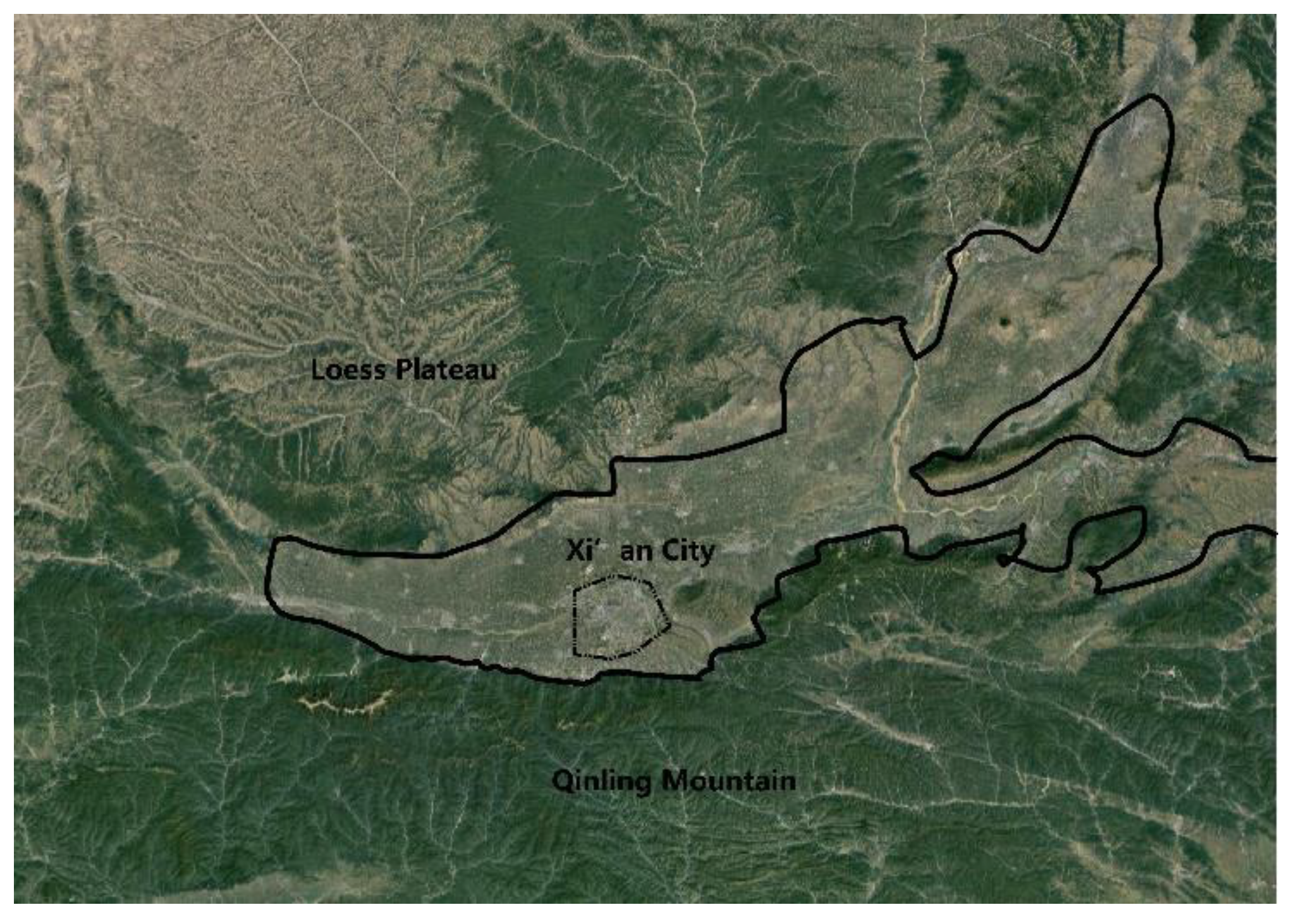
Many cities in northern China are seriously polluted in winter, especially Xi’an city, which is located in the middle of the Weihe River basin–Guanzhong basin, adjacent to the Weihe River and the Loess Plateau in the north and the Qinling Mountains in the south. Its special terrain directly leads to the severity of air pollution in winter (Figure 1).
Because of the complex situation, viruses can be easily suspended in the air and flow with the air in the form of aerosols, and its transmission distance can reach hundreds of meters or even further, increasing the risk of non-contact transmission [15]. Relevant studies have revealed that wind is connected to the occurrence, development, and prevalence of diseases and can directly or indirectly affect the spread of epidemic diseases through the replication and movement of epidemic microorganisms and vectors [16]. If an epidemic occurs, the transmission routes between the community and the outside environment should be restricted to limit the spread of the epidemic, and the indoor and outdoor spaces of residential areas will become the main place for the daily activities of the residents. Therefore, it is necessary to conduct research on the identification and control of epidemic prevention spaces in high-rise residential areas based on the wind environment.
At present, domestic and foreign scholars have mainly carried out research on optimization strategies or the evaluation of wind environments in high-rise residential areas [17,18,19,20,21,22,23,24,25,26], while relevant research on the simulation of wind environments in high-rise residential areas for epidemic prevention and control are rarely addressed by the scholars. The planning and response during public health emergencies focus on the change in concept and the call for action while ignoring the implementation of prevention spaces [27,28,29]. The COVID-19 outbreak reminds us of the importance of epidemic prevention and control in residential areas. Much work needs to be conducted to transform healthy residential areas from a concept to a reality, and it is still very difficult to realize the transformation of the core of residential areas. Planners and designers must accordingly make forward-looking responses.
Therefore, this article takes high-rise residential areas in Xi’an in winter as an example, and the identification and control of epidemic prevention spaces, field measurements, and the investigation and introduction of wind environmental simulation technology are taken into consideration to expound the characteristics of the wind environment in high-rise residential areas, the behavior characteristics of the crowd, and the spread of pollutants in the air flow field in spaces. To divide the area of the air flow field and take into consideration the double effect of population distribution and risk space for the assessment of risk and multiple identification of epidemic prevention space, recognition methods for epidemic prevention space of high-rise residential areas are proposed. Additionally, the spatial system for the prevention of epidemics characterized using “Spatial Division, Hierarchical Classification and Type Differentiated and Time Division” was developed to form a “Targeted Epidemic Prevention”-based emergency control scheme for the optimization of living environments in residential areas as well as to provide reference for improving the spatial control ability of China’s high-rise residential areas, which offers knowledge into a new concept in the prevention of epidemics in the case of daily or public health emergencies.
2. Research Design
2.1. Research Content and Objective
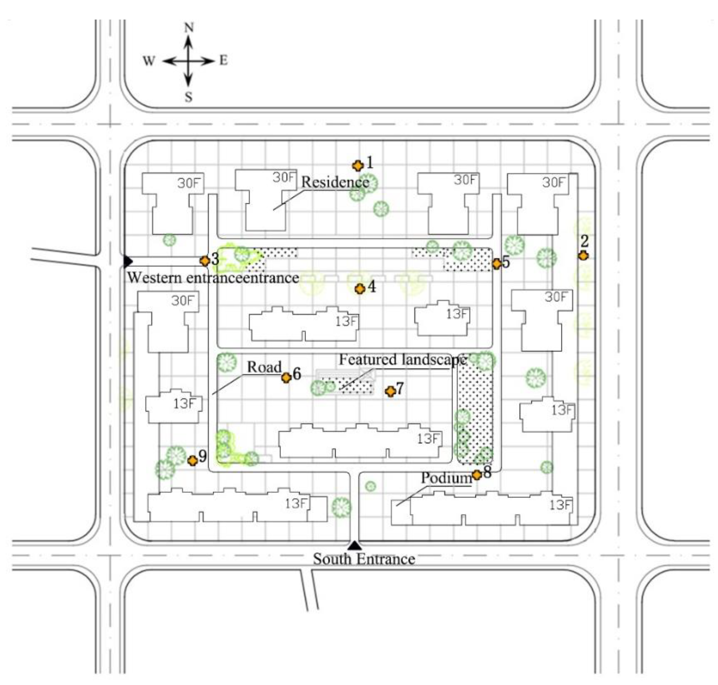
As previously mentioned, due to its special geographical conditions, Xi’an has become one of the cities with the worst air pollution in winter; therefore, the research object has great value for the population. In this study, a public residential area was selected to analyze the airflow and transmission mechanism of viruses. The object of this study is the high-rise residential area of Jingyuan in Xi’an, which is located in the Zhenguan Section of the Weiyang District, Xi’an city (Figure 2). This residential area is positioned as a middle- and high-grade residential area that emphasizes space for outdoor activities and focuses on creating leisure and entertainment. In order to ensure the scientific nature and representativeness of the research, the selected high-rise residential areas cover a variety of forms in space, including different building heights and architectural styles, and different types of air flow fields can be easily generated, which is conducive to the systematic identification of epidemic prevention spaces in high-rise residential areas and the construction of accurate control strategies. In order for the calculation results to be representative, this paper focused on the outdoor wind environment according to the dominant wind direction and the average wind speed of the dominant wind in winter in Xi’an. According to the GB 50736-2012 Design Code for Heating Ventilation and Air Conditioning of Civil Buildings [30] and the local meteorological data, the outdoor wind environmental parameters of Xi’an city in winter are determined as follows: the prevailing wind direction is from the northeast to the north and the average wind speed is 1.6 m/s.
2.2. Analytical Framework
Since the 1960s, scholars in social public management have realized that good risk management can lead to reducing the probability of errors in decision-making processes and avoiding the possibility of losses. Risk management can be divided into four stages: risk assessment, risk identification, risk control, and risk record [31]. Emerging public health events belong to the important content in the research of risk management, which is conducted by adopting the concept of targeted control for risk management (Figure 3). The pathogenesis risk can be assessed by the comparison of the associated data of “Flow Field Distribution–Population Distribution–Risky Space” to put forward a comprehensive emergency analysis framework from the perspective of spatial and temporal distribution with the focus of recognizing epidemic prevention space and control strategies, namely, to follow the logic of “Assessment–Recognition–Control“ in epidemic control.
In epidemic prevention, the logic of “Assessment–Recognition–Control” in epidemic prevention is consistent with the principles followed in space planning. Additionally, integrated innovation can be made for the subjects in the planning of urban and rural areas and in prevention science, environmental behavior, public health, and environment as well as social and public management, so that theoretical research on healthy residential areas can be transformed into practical application in space as soon as possible. Before designing the epidemic prevention space, it is necessary to fully understand the characteristics of the wind environment, human behavior, and the spatial paths of pollutant transmission in the air flow field of high-rise residential areas so as to carry out an efficient spatial response from the perspective of precise epidemic prevention.
2.3. Data Sources and Evaluation Methods
2.3.1. Data Sources and Assessment Method
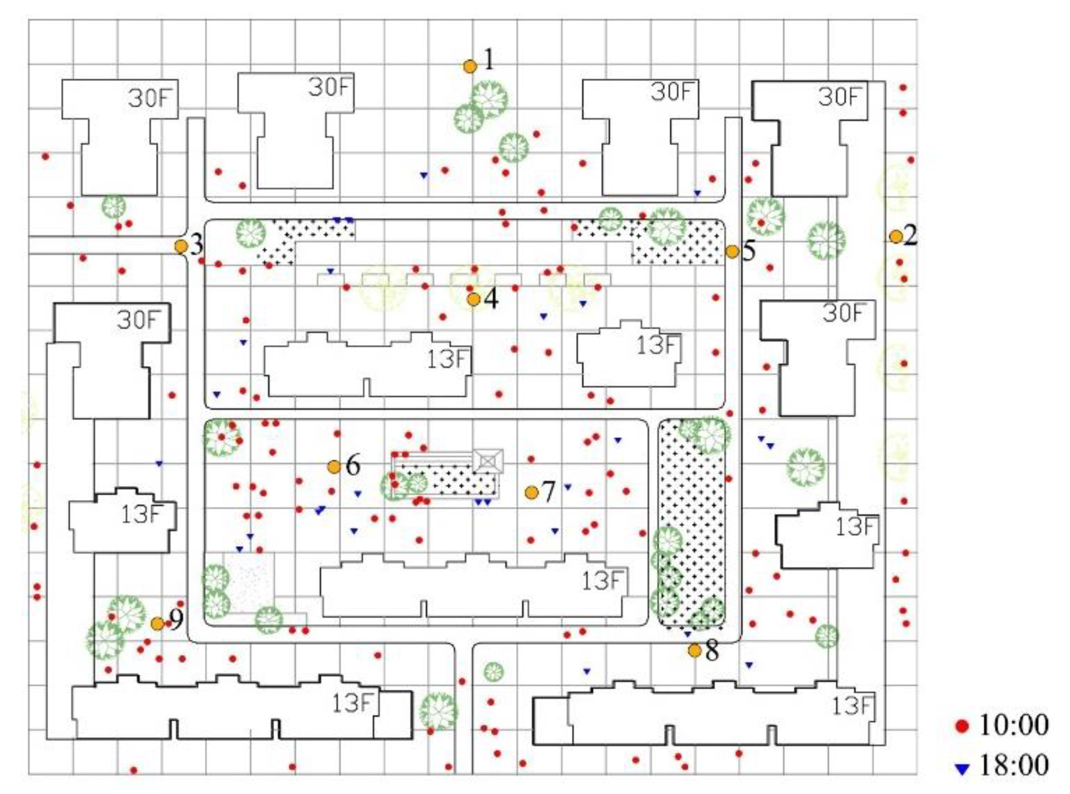
This study adopted the method of “Field Survey + Simulation” to analyze the characteristics of the wind environment, crowd behavior, and the residential area of Jingyuan in Xi‘an, combined with the spatial channels of pollutant transmission in the air flow field. This method was adopted by integrating the concept of risk management to respond to epidemics to the assessment of pathopoiesis risks, the recognition of epidemic prevention spaces, and the presentation of control and management strategies [20]. These include the following: ① Field measurement method. A total of 9 measuring points were taken into consideration and evenly arranged in the main activity space of residents (Figure 1). Typical winter meteorological days in Xi’an were selected and tested by hot-wire anemometer from 7:00 a.m. to 19:00 p.m. on 8 January 2020 to analyze the variation characteristics of the wind environment at different times in the space of residential areas of Jingyuan, so as to demonstrate the differentiated epidemic prevention and response thinking in different zones by time sharing. ② Behavior annotation method. The days 8 January 2020 (weekday) and 11 (weekend) were selected as the time to conduct the research on the behavior of the crowd in winter by collecting the distribution of the population in the residential area and numerous photos at 1 h intervals and recording the time of arrival and departure to gather statistics of the space distribution of activities of the residents, the number of people, and duration. Moreover, the law of behavior in outdoor spaces can be traced to provide support in basic data for risk assessment. ③ Simulation method for values. The 3D model for residential areas was built and relevant parameters on residential wind fields and others were set in PHOENICS 2015 to simulate and analyze the wind environment and qualitatively divide the air flow field area. The position and distribution of “Potential Risky Points” were identified by combining the double effect of crowd behavior and risk space.
The speed of the wind was less than 5 m/s as the pedestrian height around the building was less than 1.5m in the case of the prevailing wind speed and wind direction in winter by referring to the GB/T 50378-2019 “Evaluation Standards for Green Buildings” [32] and based on the existing research. Meanwhile, wind speeds greater than or equal to 1.04 m/s have no influence on the basic requirements for normal walking in outdoor spaces and dust is not raised to give rise to air pollution, which is beneficial to the disappearance of pollutants.
2.3.2. Software Simulation
According to Code for Design of Heating Ventilation and Air Conditioning of Civil Buildings (GB50736-2016), the average outdoor wind speed in Xi’an in winter is 1.6 m/s, and the prevailing wind direction is north–northeast (67.5°) [1]. PHOENICS is a reliable, cost-effective CFD program with a proven track record that can simulate fluid flow, heat or mass transfer, chemical reactions, and combustion for a wide range of applications. Considering the universality and cost-effectiveness of the engineering application, this paper used PHOENICS wind environment simulation software and the Reynolds-averaged Navier–Stokes (RANS) method to assess the wind environment of urban residential areas.
The basic concept to describe the 3D turbulent flow is described by non-hydrostatic incompressible Navier–Stokes equations in the Boussinesq-approximated form:
where and ) for i = 1,2,3. Due to air being treated as an incompressible fluid, an additional continuity equation has to be satisfied:
where (=104 sec-1) is the Coriolis parameter, is the local pressure perturbation, and is the potential temperature at level z. The temperature should represent average mesoscale conditions and is provided by a one-dimensional model running parallel to the main model.
According to the recommendations of the Japanese Architectural Society (AIJ), the size of the computing domain is 1300 (x) × 1300 (y) × 270 (z) (Table 1), setting the radius of the calculation field as 5 H and the height as 4 H based on the target building. The key researched area (1.5 m high in the pedestrian area) is the fifth grid above the ground, and the height of other grid cells are same. The AIJ suggests that each side of the building should be divided into at least 10 grids, so a horizontal and vertical hierarchy was created: the grid resolution was set to a 1 × 1 × 2 pixel system, and a sparse grid was set around with the grid gradient set to 1.3. We also compared the standard k-ε model and RNG k-ε predictability of turbulence in the model. Finding that the standard k-ε model is in good agreement with the experimental results for weak wind environment prediction, the standard k-ε model was selected. In this paper, the number of iterations was set as 2000 and the step size was 1. The calculations were stopped when the solution was fully convergent, and it was determined that the value of the specified observation point no longer changed or the root-mean-square residual was less than 10E-4.
Based on the above simulation mode, the software program mentioned above was employed for the calculation of the wind environment.
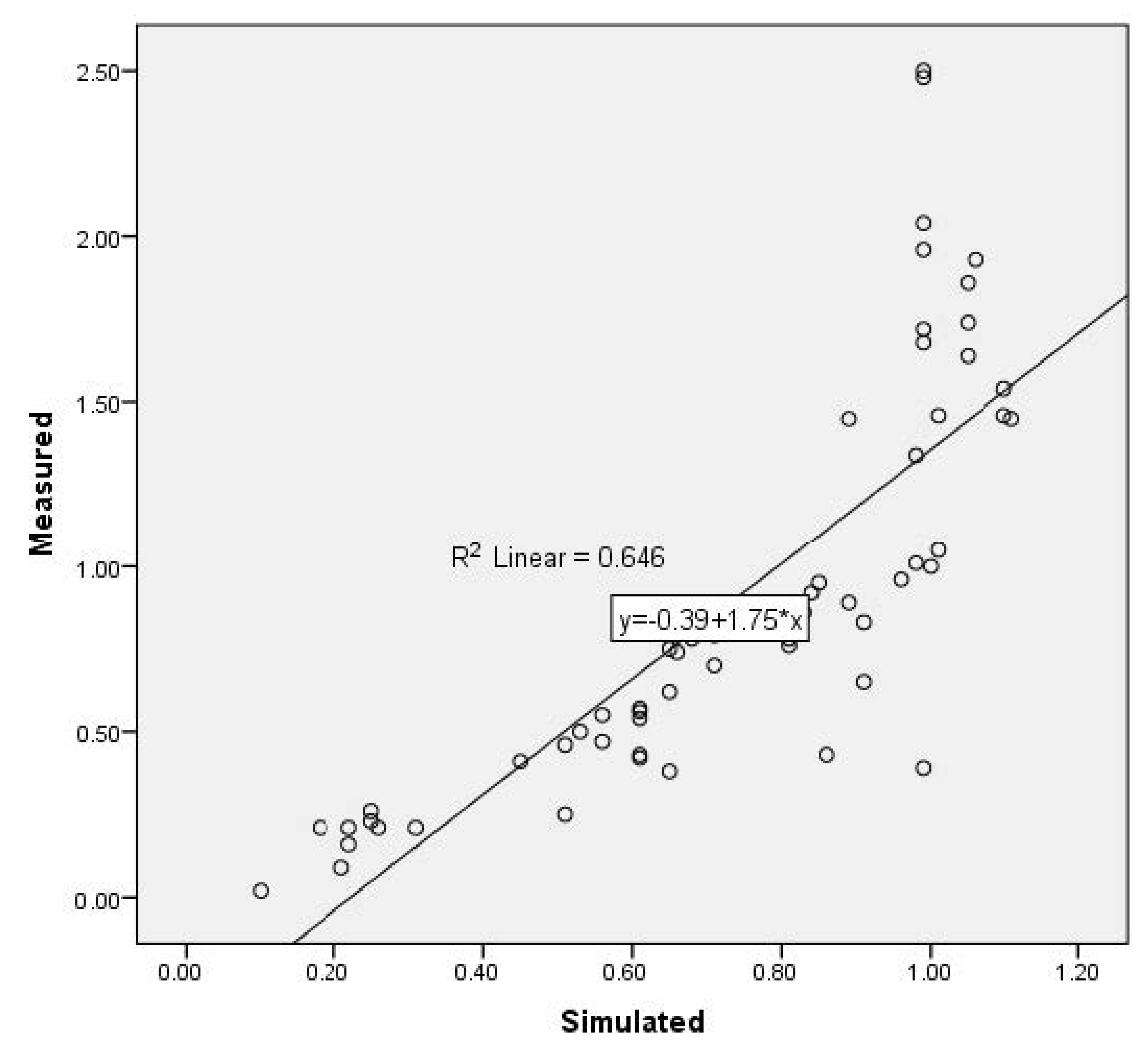
2.3.3. Validation of the Measured and Simulated Data
In this step, the process was validated through a comparison between the field measurements and simulation results. The coefficient of determination (R2), a measurement predicting the difference between the predicted and observed data, was used for assessing the accuracy of the software. The final result shows that the R2 is 0.646, which also explains that the software can fully restore the existing wind environment (Figure 4).
2.4. Research Foundation
2.4.1. Characteristics of the Wind Environment
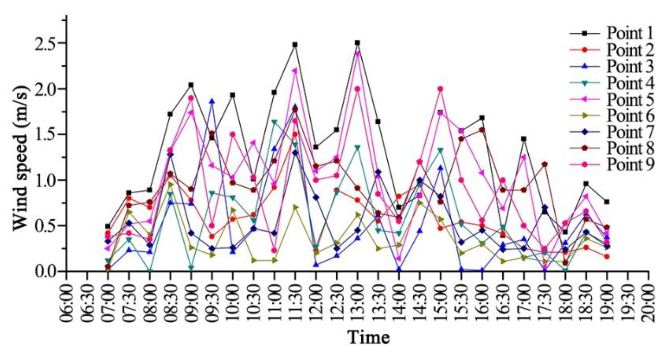
The wind speed at different spatial measuring points in high-rise residential areas varies greatly (Figure 5), and there are differences in the dispersal ability of air pollutants. Therefore, precise and efficient epidemic prevention should be carried out in different spaces. There was no obvious uniform law of wind speed variation in the test period (Figure 6). However, the wind speeds from 7:00 a.m. to 8:00 a.m. and from 18:00 p.m. to 19:00 p.m. were lower than 1.04 m/s, which is not conducive to the natural dissipation of pollutants. Therefore, the times mentioned above can be taken as the key periods for epidemic prevention in daily or public health emergencies.
2.4.2. Behavioral Characteristics of the Population
- (1)
- Time distribution and activity duration
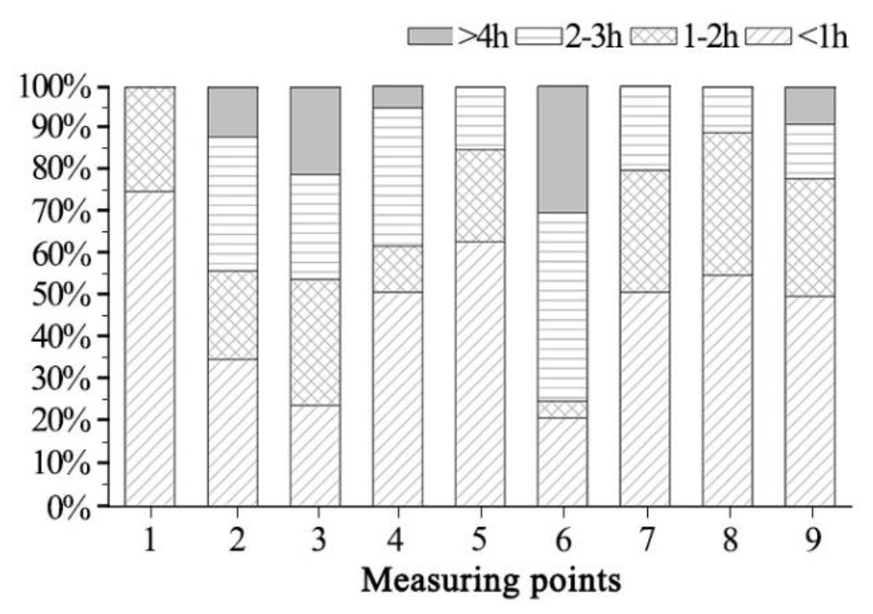
Through the on-site observation of people flow and activities, the working days and weekends in the residential area of Jingyuan in winter and the statistical results about outdoor activities are shown in Figure 7. People flow and activities occurred from 9:00 a.m. to 10:00 a.m. and from 14:00 p.m. to 15:00 p.m. There were less people performing outdoor activities from 12:00 a.m.–13:00 p.m. The number of people performing activities in the morning exceeded those in the afternoon, and the control of people’s behavior should be conducted in a better way according to time division. There were residents with activity durations of more than 4 h in measuring point 3 and measuring point 6, which take up the larger proportion of all the people. Simultaneously, there were relatively more people with an activity duration of less than 1 h in measuring point 1 and measuring point 5 (Figure 8). It can be seen that the activity duration in areas with less wind speed in winter is larger than those in areas with higher wind speed.
- (2)
- Population distribution and space utilization
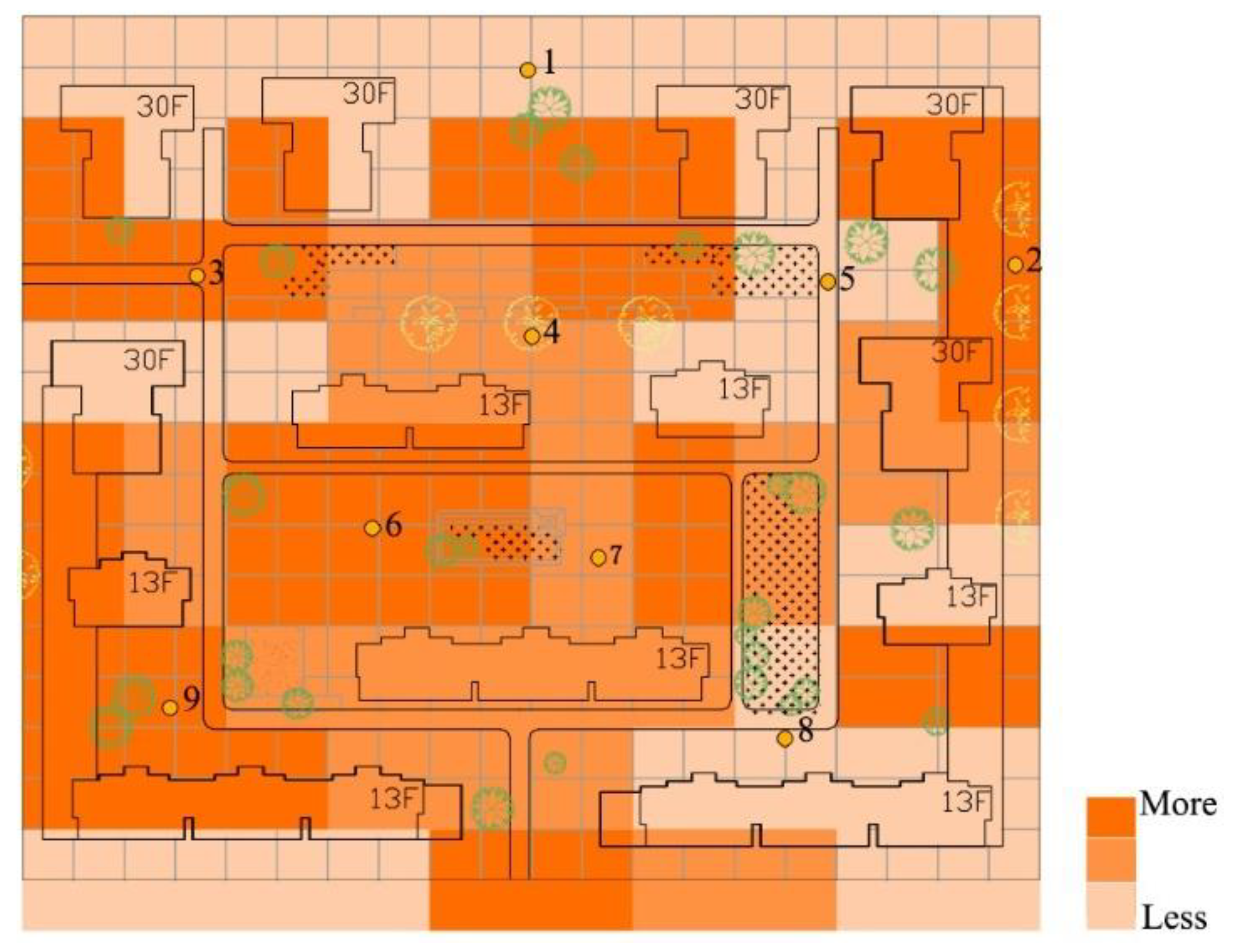
To annotate and assess statistics for the number of people performing activities in winter in the residential area of Jingyuan (Figure 9) to analyze the distribution of residents performing outdoor activities, people at 10:00 a.m. were chosen as the representatives for daytime and 18:00 p.m. was selected as the time for statistics at night, as during this period, there is no light outdoors, which leads to a difference compared to the daytime. In order to facilitate the comparative analysis of the distribution of the number of residents in the residential space, the square with an equal area of the site was divided into several parts, and the color of the block varies from light to dark, respectively representing the change in utilization rate from low to high. As can be seen in Figure 10, the utilization rates of measuring points 2, 3, 6 and 9 were the highest. Additionally, the overall wind speed of this space is low, and the residents frequently take shelter from the wind here in winter. The utilization rates of measuring points 4 and 7 were only second to those of the above-mentioned measuring points. The utilization of measuring points 5 and 8 was the lowest in comparison with that of all points mentioned. The wind speed is high in low-wind environments in winter, which causes greater interference to residents performing outdoor activities. According to the above analysis, the daily activities of residents are mainly conducted in areas with a low wind speed.
2.4.3. Spatial Path of Pollutant Transmission in Air Flow Fields
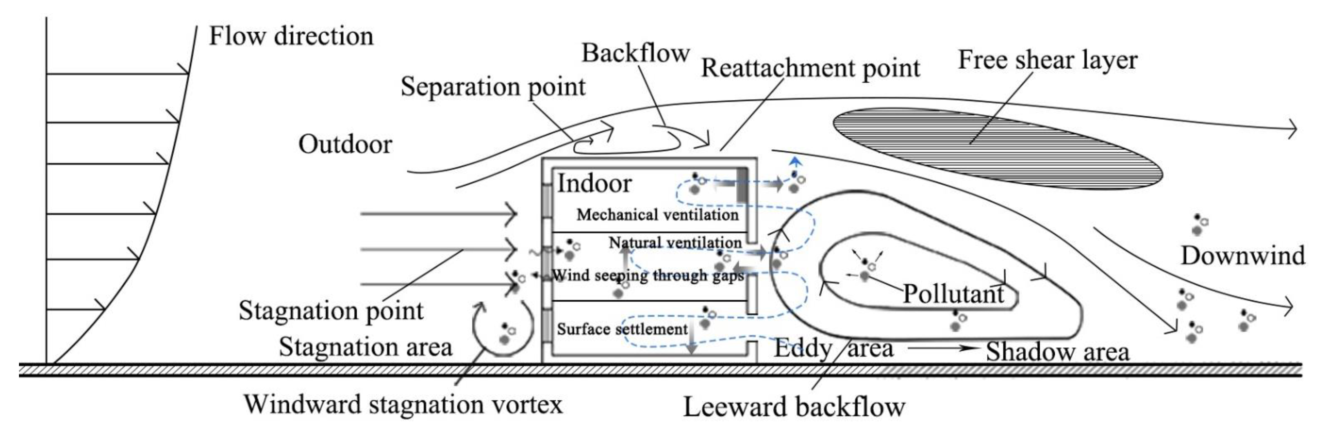
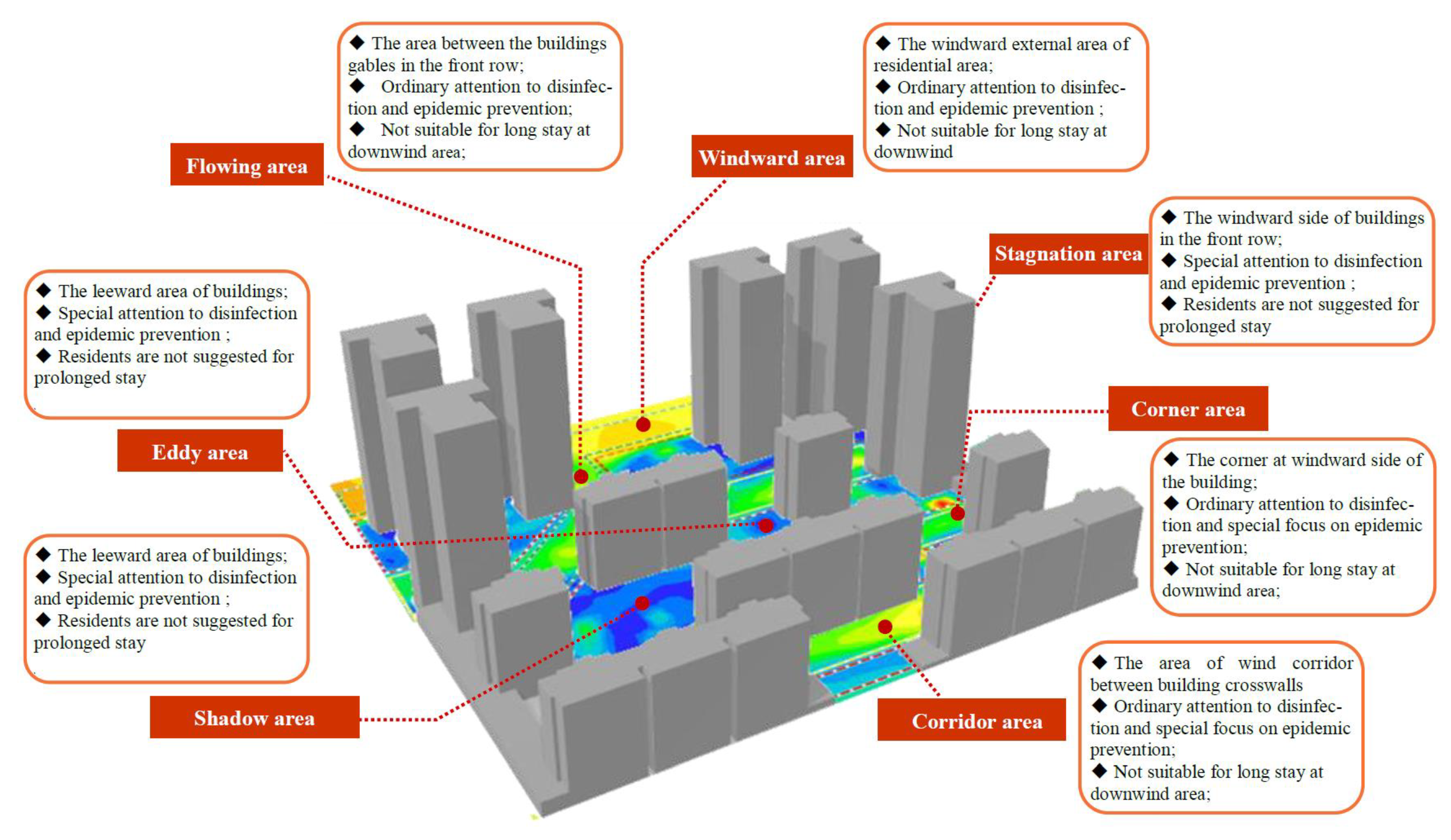
A different air distribution can be generated by different air flow fields, and as biological particles are presented in form of aerosols by integrating into airborne pollutants, the movement in different air distribution patterns is different [33] (Figure 11). There is significant resistance as the wind flows through the buildings. There are areas with less wind speed as the wind fails to pass through the side area of the building, namely, the shadow areas, in which eddy wind can also be easily generated due to the backflow phenomenon of the wind. These areas form near the building, slowing down or trapping germs in the swirling air flow and easily exchanging with indoor air to cause cross-infection. In the air flow field areas with better ventilation in residential areas (windward areas, flowing areas, corner areas, and corridor areas), air in high eddy wind is capable of carrying viruses in the upward direction to the downwind area, which is harmful for the health of residents [34].
3. Spatial Identification of Epidemic Prevention Spaces in High-Rise Residential Areas Based on the Wind Environment
According to the above-mentioned analysis and in order to facilitate the conduction of the analysis and identification of the epidemic prevention space from the perspective of the wind environment, firstly, CFD was used for the simulation of the wind environment of the high-rise residential area. The air flow field of the residential area was divided according to the condition of ordinary flow and there were seven areas in total: windward area, flowing area, corner area, corridor area, stagnation area, shadow area, and eddy area [35]. Secondly, based on the overlay analysis of “Flow Field Distribution–Population Distribution–Risky Space”, the risk of pathopoiesis of different spaces in high-rise residential areas can be assessed in a rational way. Finally, based on the concept of the control of the spatial division stipulated in “Standards in Comprehensive Epidemic Prevention in Urban Area (GB/T 51327-2018)”, the spatial division of the area with pathopoiesis can be established so as to build the foundation for epidemic control in high-rise residential areas (see Figure 12).
Based on the analysis of “Flow Field Distribution–Population Distribution–Risky Space”, the risks of different spaces in the high-rise residential area were assessed (Table 2): (1) The overall wind speed of the windward external area of the high-rise residential area and the area between the buildings gables in the front row is greater than 1.04 m/s, which is conducive for the natural dissipation for pollutants. Due to the diminishing velocity of the wind in the flow direction, the safety of the external fresh air should be ensured to prevent the input of air carrying a virus from the outside, resulting in the accumulation of the virus in the downwind area. However, the utilization rate of the space in the two regions is the lowest and the air flow field can hardly cause a negative influence on the indoor air quality, so the risk of pathopoiesis is relatively lower. (2) The wind speed of the corner of the windward side of the high-rise residential area and the area of the wind corridor between building crosswalls is about 1.04 m/s, which is conducive to the natural dissipation of pollutants. However, the dissipation level is limited, and the speed of incoming flow can be strengthened in the upwind direction of the corner and corridor areas, which is beneficial to the transmission of virus to the downwind direction, and thus the virus in the upwind direction is diluted. As the wind speed diminishes in the downwind area, the virus can accumulate and the utilization rate of the downward space by the residents is high, which increases the possibility of virus infection with certain risk of pathopoiesis. (3) The wind speed of the windward side of the front row of high-rise buildings and the leeward side of buildings is less than 1.04 m/s, which is not beneficial to the natural dissipation of outdoor pollutants and is more likely to cause cross-infection. The utilization rate of such areas by residents is the highest, which will definitely increase the hidden danger of cross-infection with a high risk of pathopoiesis. Above all, the pathopoiesis risk is relatively low in the windward external area of high-rise residential areas and the area between the gables of the front row of buildings. There are certain risks in the downwind direction of the corner of the windward side of high-rise residential areas and the wind corridor between the crosswalls of buildings, which is acknowledged as an area with moderate risk of pathopoiesia. The windward side of the front row of buildings of high-rise residential areas and the leeward side of buildings are considered to carry a risk of cross-infection with high pathopoiesis.
4. Spatial Control Strategies to Respond to Emerging Epidemics in High-Rise Residential Areas
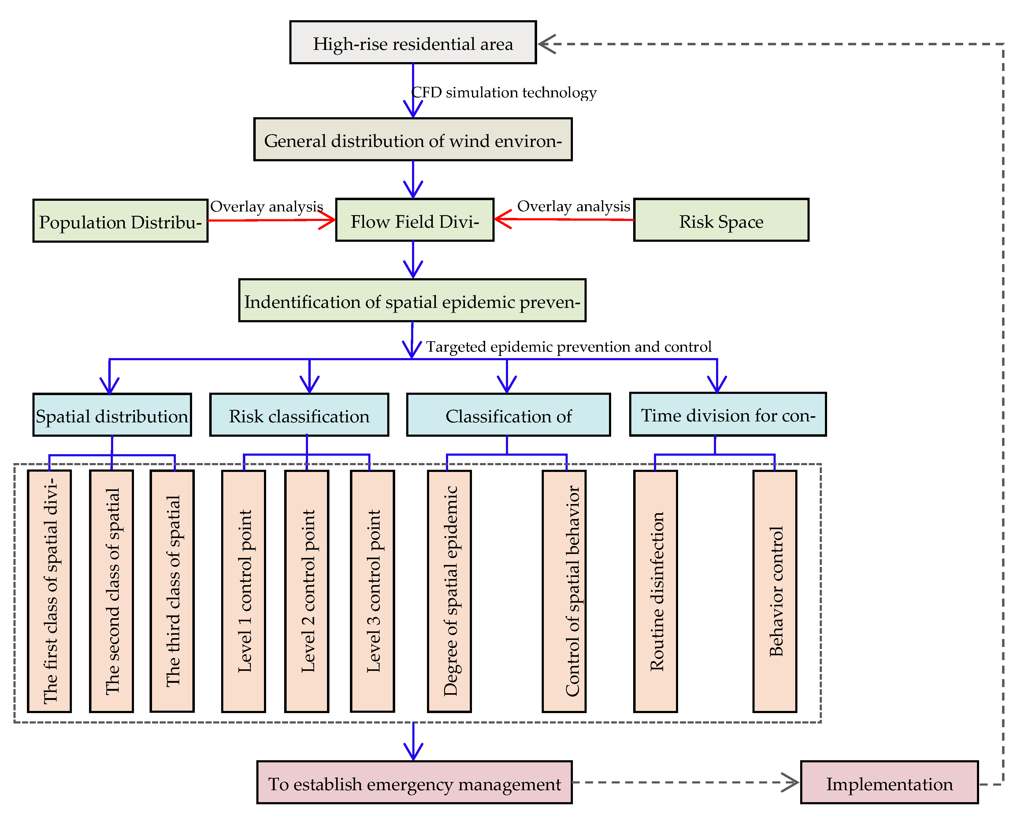
Scientific epidemic prevention and control should be conducted by the building of a hierarchical, dynamic, and detailed prevention and control plan, so that a scientific and timely response to the disease can be achieved at the lowest cost, and the comprehensive goals for epidemic prevention and control and social and economic development can be coordinated [36]. This research was conducted with the construction of a spatial system for epidemic prevention in high-rise residential areas based on the “Spatial Division, Hierarchical Classification and Type Differentiated and Time Division” by considering the spatial system of comprehensive disaster prevention, which includes spatial division, risk classification, classification of measures, and time division for control (Figure 13, Figure 14, Figure 15 and Figure 16, and Table 3).
4.1. Spatial System for Epidemic Prevention for High-Rise Residential Areas Based on “Spatial Division, Hierarchical Classification and Type Differentiated and Time Division”
- (1)
- Spatial division for epidemic prevention in high-rise residential areas
For epidemic prevention, zones can be created to provide emergency guidance. According to the risk assessment of pathopoiesis of high-rise residential spaces, the high-rise residential area is regarded as the main body for epidemic prevention, and the spatial divisions are created for epidemic prevention. The leeward side of buildings of the high-rise residential area and the windward side of the front row of buildings are regarded as the first level of spatial division for epidemic prevention. The corner of the windward side of the buildings and the wind corridor between the building crosswalls are classified as the second level of spatial division for epidemic prevention. Moreover, the external edge of the windward side of the residential area and the area between the building gables of the front row are known as the third level of spatial division for epidemic prevention.
The outdoor activities of residents should be conducted according to the different spatial divisions for epidemic prevention and the corresponding warning signs, and epidemic prevention and control centers in residential areas should be set up to clarify the rights and responsibilities of different epidemic prevention zones so as to facilitate the unified management of spatial rights and responsibilities. Epidemic prevention and sanitation facilities will thus be improved in residential areas, and successful epidemic prevention for daily or public health emergencies can be conducted.
- (2)
- The classification of the risks of epidemic prevention in high-rise residential areas
Risks are classified to strengthen precise epidemic prevention. Hierarchical control should be conducted by considering indoor and outdoor risk conditions based on construction plans for high-rise residential areas: As the residence is the main place of living for people, the shadow area, eddy area, and stagnation area formed in the periphery of the building are not conducive to the dissipation of pollutants. As a result, air carrying viruses can enter the indoor environment and the virus can lead to a more polluted area by returning air with a strong infectivity once the outbreak has emerged. Therefore, the leeward side of the high-rise building and the windward side of the front row of the building can be implemented, operating first-level control with the purpose of preventing it from spreading indoors. The wind speed in the upwind direction of the corner area and corridor area is fast, which is conducive to reducing the concentration of the virus to safety levels. However, the flowing air can carry the virus from a neighboring area to the downwind area, and as a result, the residents in the downwind area can become prone to infection. Therefore, a second level of control can be conducted in the corner area of the windward side of the building and the area of wind corridor between the building crosswalls to prevent wind circulation from the outside. As the air in the windward and flowing areas moves with ease, pathogenic bacteria cannot accumulate with ease. The quality of the indoor air can be influenced by the outdoor air, and the third level of control can be enforced to prevent the input of external pathogenic bacteria.
- (3)
- Classification of epidemic prevention measures in high-rise residential areas
Multiple measures can be applied and classified simultaneously. In high-rise residential areas, measures should be undertaken to improve the system of measures for epidemic prevention at the two levels of spatial epidemic prevention and spatial behavior control. In terms of the spatial epidemic prevention degree, a specific targeted space for elimination should be defined to carry out precise epidemic prevention. In the leeward side of high-rise buildings and the windward side of buildings in the front row, daily key cleaning and disinfection should be conducted, which should be taken as the key epidemic prevention areas in the case of public health emergencies. Daily cleaning and disinfection work should be conducted in the corner area of the windward side of the building and the wind corridor between the building crosswalls, which should be taken as key epidemic prevention areas in the case of public health emergencies. Daily cleaning and disinfection should also be carried out at the windward edge of residential areas and between the gable walls of buildings in the front row, and the areas should be used as common epidemic prevention areas in the case of public health emergencies. In terms of spatial behavior control, it is necessary to make clear that residents cannot stay in the space and to adopt corresponding outdoor activity space control, which is a necessary response strategy to control the spread of the epidemic. The windward side of buildings in the front row, the leeward side of high-rise buildings, and the downwind area with large wind speeds are the main spaces in which residents should not stay. Pollutants in these areas cannot dissipate with ease. When the concentration of the virus in the air reaches a certain level, it will lead to the infection of residents exposed to this air for a long time. On the basis of ensuring human comfort, the spaces with sound ventilation (including the upwind area of the windward corner area, the windward external area of the high-rise residential area, the gables of the front row of buildings, and the corridor area) are conducive to reducing the concentration of the infectious virus below the safety level in the air, which can be used as residential spaces suitable for activities. Thus, the epidemic prevention of individuals can be conducted well.
- (4)
- Time division for epidemic prevention and control in high-rise residential areas
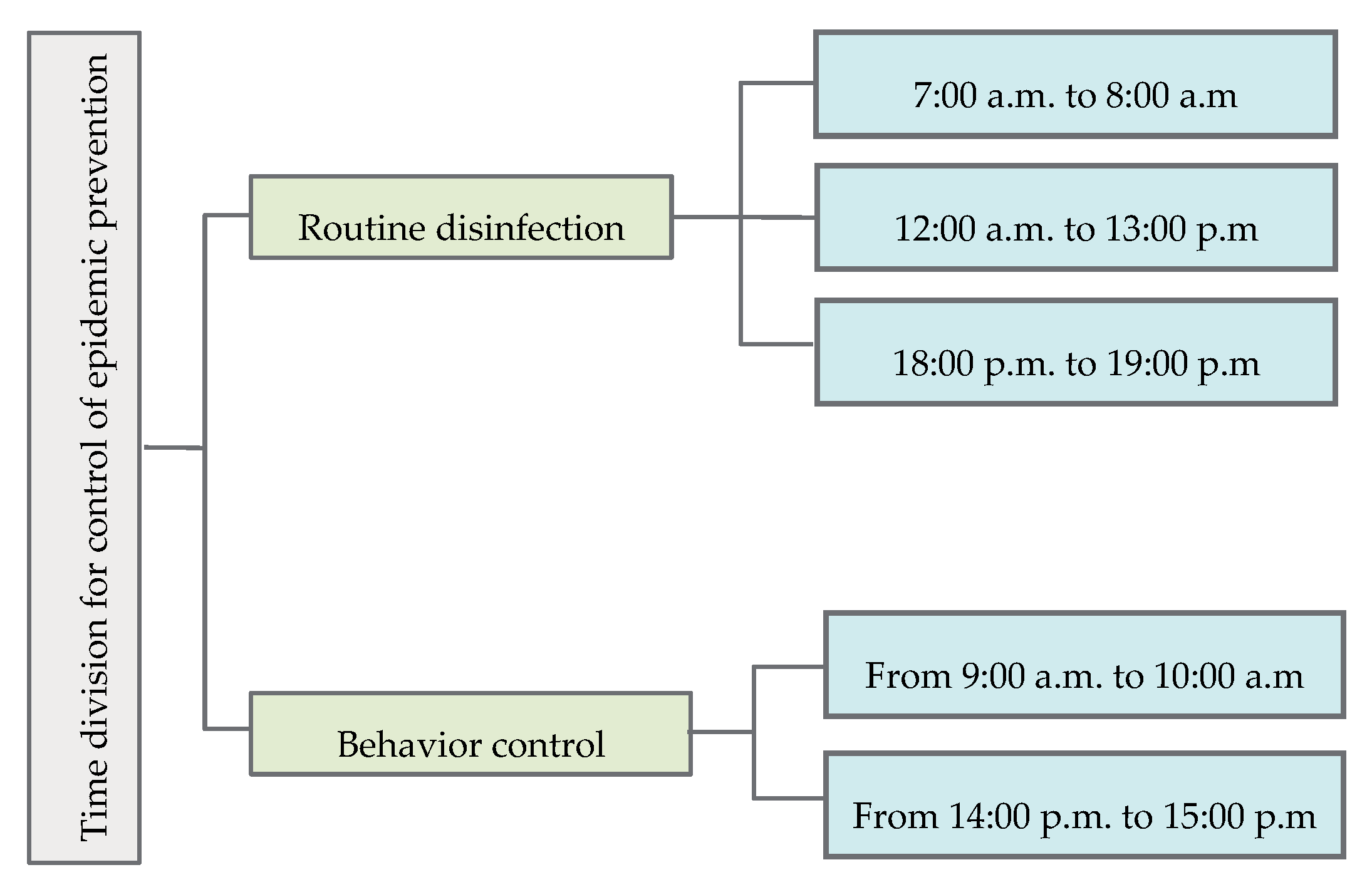
Time-division-based control should be implemented efficiently. According to the field measurements of the wind environment and the investigation of crowd behavior, the wind speed is lower than 1.04 m/s from 7:00 a.m. to 8:00 a.m. in the morning and from 18:00 p.m. to 19:00 p.m. in the evening, which is not conducive to the natural dissipation of pollutants. In winter, the main times for outdoor activities on weekends and working days are at 9:00 a.m.–10:00 a.m. and 14:00 p.m.–15:00 p.m., and the number of residents for outdoor activities is the lowest between 12:00 a.m. and 13:00 p.m. In order to ensure the health and safety of residents for outdoor activities in daily or public health emergencies, disinfection should be carried out in the morning from 7:00 a.m. to 8:00 a.m., from 12:00 a.m.–13:00 p.m., and from 18:00 p.m. to 19:00 p.m., and space behavior control should be carried out from 9:00 a.m.–10:00 a.m. and 14:00 p.m.–15:00 p.m.
4.2. The Establishment of a “Targeted Epidemic Prevention”-Based Emergency Management and Control Plan
The outbreak of the novel coronavirus at a large scale has attracted the concern of many scholars working in emerging health events with a focus on the transformation of concepts and calls for action. However, there is inadequate concern regarding the control plan for epidemic prevention in spaces, and maneuverability is not displayed. Therefore, the targeted emergence response plan was formulated from the perspective of the wind environment and the different spaces of high-rise residential areas (Figure 17 and Figure 18). To be specific, spatial divisions for air flow can be made as a basis, space identification for epidemic prevention can be regarded as the driving factor, and targeted management can thus be guaranteed.
- (1)
- Air flow can be made as the basis. CFD technology was adopted to simulate the wind environment of high-rise residential areas; as a result, the spatial division of air flow was not the only factor considered. The location and distribution of the people and risk spaces were also taken into consideration, including temporal distribution and duration of activities, the distribution of people and space utilization, and the transmission channels in the space of pollutants in the air flow field, which provide basic data support for the prevention and control of all kinds of emergency planning.
- (2)
- Space identification for epidemic prevention is the driving factor. Based on the spatial division of the air flow field and the double effect of “Population Distribution-Risk Space”, the multiple identification and evaluation of “Pathogenic Potential Risk Points” were conducted, which can accurately describe the pathogenic risks of different spatial environments in high-rise residential areas, establish multilevel areas with pathopoiesis, provide spatial information support for the establishment of epidemic prevention systems, and assist the decision-making processes for spatial control.
- (3)
- Targeted management should be guaranteed. The establishment of a spatial system for epidemic prevention based on “Spatial Division, Hierarchical Classification and Type Differentiated and Time Division” is conducive to the establishment of spatial rights, facilitating emergency organization and management, ensuring the implementation of epidemic prevention measures, and enhancing the epidemic prevention and response capability of high-rise residential areas in a dynamic and diversified way. The intensification of concept in control was developed to avoid rigid controls based on “One Size Fits All” approaches. Additionally, it is conducive to preventing relaxed attitudes toward epidemic prevention and control, and the main contents include spatial division, risk classification, classification of measures, and time division for control. The accurate control of spaces in the case of daily or public health emergencies can be achieved through the space layout with various elements.
4.3. Optimization of the Living Environment of High-Rise Residential Areas for Healthy Living Spaces
Infectious diseases seriously affect the health of residents in high-rise residential areas and that of the living environment of high-rise residential areas, and to a certain extent, the living environment in the high-rise residential area will exacerbate the spread of the disease. Therefore, the construction and improvement of the living environment in high-rise residential areas is conducive to curbing the spread of infectious diseases [37].
In view of the current situation of epidemic prevention in high-rise residential spaces and daily or public health emergency management and control, the spatial division for epidemic prevention, the layout of control points for epidemic prevention, key elimination spaces and the staying spaces not suitable for residents, and the key times for control of epidemic prevention should be clarified to effectively protect the health and safety of residents. In terms of the improvement of human living environments, it is necessary to set up complete emergency service facilities, mainly including command, medical treatment, material storage, shelter, and a sign guidance system, and a daily test system should be implemented for residents in high-rise residential areas.
For the construction of new high-rise residential areas in the future, attention should be paid to safety and health in addition to the requirements for the basic living, and the natural ventilation and circulation of fresh air should be considered in the layout design of buildings. For example, landscape design for residential areas can be made by considering the poorly ventilated spaces, which can not only improve the environmental quality of residential areas, but also prevent residents from staying there for a long time to prevent virus infection. By designing, e.g., stilt buildings, the ventilation of the residential area near the ground can be promoted on the premise of ensuring the floor area ratio.
5. Conclusions
In our study, based on the residential area of Jingyuan in Xi’an from the perspective of the wind environment, methods of spatial recognition of epidemic prevention are proposed in high-rise residential areas and a spatial system for epidemic prevention in high-rise residential areas was constructed to form the “Targeted Epidemic Prevention”-based emergence response control plan in high-rise residential areas so as to optimize the spatial control strategy in response to emerging outbreaks.
The fluctuating, unsteady air flows at the pedestrian level were calculated and can be used to understand how the virus spreads in the air. The requirements for epidemic prevention should be considered in the entire process of planning, construction, and management of current high-rise residential areas and newly built high-rise residential areas in the future so as to deal with daily or emerging public health events and to provide reference for improving the spatial control ability of China’s high-rise residential areas. Thus, new ideas for epidemic prevention and control under emerging health events can be proposed.
Our final results can be a strong guideline to obtain in-depth knowledge about the transmission of viruses in the air. In future studies, we will continue to study the transmission mechanism of viruses in the air.
6. Limitations and Outlook
In our study, we only considered the impact of wind on the transmission of viruses. Thus, the heat balance between the building and surface is beyond our scope, but in our future studies, we will continue to research the influence of heat balance on air flows.
Author Contributions
Writing—original draft preparation, J.Z. (Jianxin Zhang) and S.J.; writing—review and editing, J.Z. (Jingyuan Zhao) and X.M.; supervision, J.Z. (Jingyuan Zhao); funding acquisition, J.Z. (Jianxin Zhang). All authors have read and agreed to the published version of the manuscript.
Funding
This research was funded by the National Key R&D Program of China (2019YFD1100905), Natural Science Foundation of Shaanxi Province of China (2019JM-475), the Fundamental Research Funds for the Central Universities (300102418104), Shaanxi science and technology plan project key R & D plan general project (2022SF-066), and Research project on major theoretical and practical issues of philosophy and Social Sciences in Shaanxi Province (2022ND0245).
Institutional Review Board Statement
This study does not require ethical approval and we exclude this statement.
Informed Consent Statement
Not applicable.
Data Availability Statement
Not applicable.
Conflicts of Interest
The authors declare no conflict of interest. The funders had no role in the design of the study; in the collection, analyses, or interpretation of data; in the writing of the manuscript, or in the decision to publish the results.
Abbreviations
| Computational fluid dynamics | CFD |
References
- Liu, F.; Peng, R.; Huang, J.; Peng, Y. Plana and strategies of cities for coping with public health emergencies—A case study of Wuhan city. Planners 2020, 36, 72–77. [Google Scholar]
- Blocken, B.B.; Carmeliet, J. Pedestrian Wind Environment around Buildings: Literature Review and Practical Examples. J. Therm. Envel. Build. Sci. 2004, 28, 107–159. [Google Scholar] [CrossRef]
- Li, M.; Li, C.; Zhang, M. Exploring the spatial spillover effects of industrialization and urbanization factors on pollutants emissions in China’s Huang-Huai-Hai region. J. Clean. Prod. 2018, 195, 154–162. [Google Scholar] [CrossRef]
- Stathopoulos, T.; Hajra, B.; Bahloul, A. Analytical Evaluation of Dispersion of Exhaust from Rooftop Stacks on Buildings; Studies and Research Projects/Report R-576, Montréal; Institut de recherche Robert-Sauvé en santé et en sécurité du travail: Montréal, QC, Canada, 2008. [Google Scholar]
- Gousseau, P.; Blocken, B.; Stathopoulos, T.; van Heijst, G.J.F. CFD simulation of near-field pollutant dispersion on a high-resolution grid: A case study by LES and RANS for a building group in downtown Montreal. Atmos. Environ. 2011, 45, 266–279. [Google Scholar] [CrossRef] [Green Version]
- Ebrahimi, M.; Jahangirian, A. New analytical formulations for calculation of dispersion parameters of Gaussian model using parallel CFD. Environ. Fluid Mech. 2013, 13, 125–144. [Google Scholar] [CrossRef]
- Blocken, B.J.E. Computational Fluid Dynamics for urban physics: Importance, scales, possibilities, limitations and ten tips and tricks towards accurate and reliable simulations. Build. Environ. 2015, 91, 219–245. [Google Scholar] [CrossRef] [Green Version]
- Liu, S.; Pan, W.; Zhang, H.; Cheng, X.; Long, Z.; Chen, Q. CFD simulations of wind distribution in an urban community with a full-scale geometrical model. Build. Environ. 2017, 117, 11–23. [Google Scholar] [CrossRef]
- Liu, W.; You, R.; Zhang, J.; Chen, Q. Development of a fast fluid dynamics-based adjoint method for the inverse design of indoor environments. J. Build. Perform. Simul. 2017, 10, 326–343. [Google Scholar] [CrossRef]
- Lotrecchiano, N.; Sofia, D.; Giuliano, A.; Barletta, D.; Poletto, M. Pollution Dispersion from a Fire Using a Gaussian Plume Model. Int. J. Saf. Secur. Eng. 2020, 10, 431–439. [Google Scholar] [CrossRef]
- Mangia, C.; DeGrazia, G.A.; Rizza, U. An Integral Formulation for the Dispersion Parameters in a Shear–Buoyancy-Driven Planetary Boundary Layer for Use in a Gaussian Model for Tall Stacks. J. Appl. Meteorol. 2000, 39, 1913–1922. [Google Scholar] [CrossRef]
- Qin, H.; Hong, B.; Huang, B.; Cui, X.; Zhang, T. How dynamic growth of avenue trees affects particulate matter dispersion: CFD simulations in street canyons. Sustain. Cities Soc. 2020, 61, 102331. [Google Scholar] [CrossRef]
- Tominaga, Y.; Mochida, A.; Yoshie, R.; Kataoka, H.; Nozu, T.; Yoshikawa, M.; Shirasawa, T. AIJ guidelines for practical applications of CFD to pedestrian wind environment around buildings. J. Wind Eng. Ind. Aerodyn. 2008, 96, 1749–1761. [Google Scholar] [CrossRef]
- Zhen, M.; Zhou, D.; He, Y.; Yu, C.W.; Liu, Y.; Dong, Q. A review of breathable residential areas in Xi’an of China. Archit. Sci. Rev. 2018, 62, 58–65. [Google Scholar] [CrossRef]
- Qian, H.; Zhang, C.; Zheng, X. Mechanism and prediction method of aerosol transmission of respiratory infectious diseases. Chin. Sci. Bull. 2008, 63, 931–939. [Google Scholar] [CrossRef] [Green Version]
- Tu, G. Control of Nosocomial Infection and Airborne Transmission; Chinese Biosafety Committee, Collection of Biosafety Lectures: Beijing, China, 2004; pp. 311–320. [Google Scholar]
- Dong, X. Transmission Routes and Control of Epidemic Diseases in Buildings and Residential Area; Tsinghua University: Beijing, China, 2005. [Google Scholar]
- Hu, Y.; Liu, Z.; Tan, H. Study on influence of block scale based building layout on ventilation performance and evaluation method. Build. Sci. 2017, 33, 108–114. [Google Scholar]
- Zeng, S.; Tian, J.; Zeng, J. Study on ventilation efficiency and optimal layout of typical residential modules based on CFD simulation. Archit. J. 2019, 2, 24–30. [Google Scholar]
- Shui, T.; Liu, J.; Yuan, Q.; Qu, Y.; Jin, H.; Cao, J.; Liu, L.; Chen, X. Assessment of pedestrian-level wi-nd conditions in severe cold regions of China. Build. Environ. 2018, 135, 53–67. [Google Scholar] [CrossRef]
- Tang, J.W.; Nicolle, A.D.; Klettner, C.A.; Pantelic, J.; Wang, L.; Bin Suhaimi, A.; Tan, A.Y.L.; Ong, G.W.X.; Su, R.; Sekhar, C.; et al. Airflow Dynamics of Human Jets: Sneezing and Breathing—Potential Sources of Infectious Aerosols. PLoS ONE 2013, 8, e59970. [Google Scholar] [CrossRef] [Green Version]
- Nair, A.N.; Anand, P.; George, A.; Mondal, N. A review of strategies and their effectiveness in reducing indoor airborne transmission and improving indoor air quality. Environ. Res. 2022, 213, 113579. [Google Scholar] [CrossRef]
- Morawska, L.; Tang, J.W.; Bahnfleth, W.; Bluyssen, P.M.; Boerstra, A.; Buonanno, G.; Cao, J.; Dancer, S.; Floto, A.; Franchimon, F.; et al. How can airborne transmission of COVID-19 indoors be minimised? Environ. Int. 2020, 142, 105832. [Google Scholar] [CrossRef]
- Sajeev, V.; Anand, P.; George, A. Chapter 12—Indoor Air Pollution, Occupant Health, and Building System Controls—A COVID-19 Perspective; Aymen, A., Abdeltif, A., Tuan, A.N., Eds.; Hybrid and Combined Processes for Air Pollution Control; Elsevier: Amsterdam, The Netherlands, 2022; pp. 291–306. [Google Scholar] [CrossRef]
- Morawska, L.; Milton, D.K. It Is Time to Address Airborne Transmission of Coronavirus Disease 2019 (COVID-19). Clin. Infect. Dis. 2020, 71, 2311–2313. [Google Scholar] [CrossRef] [PubMed]
- Tang, J.W.; Bahnfleth, W.P.; Bluyssen, P.M.; Buonanno, G.; Jimenez, J.L.; Kurnitski, J.; Li, Y.; Miller, S.; Sekhar, C.; Morawska, L.; et al. Dismantling myths on the airborne transmission of severe acute respiratory syndrome coronavirus-2 (SARS-CoV-2). J. Hosp. Infect. 2021, 110, 89–96. [Google Scholar] [CrossRef]
- Tsichritzis, L.; Nikolopoulou, M. The effect of building height and façade area ratio on pedestrian wind comfort of London. J. Wind. Eng. Ind. Aerodyn. 2019, 191, 63–75. [Google Scholar] [CrossRef]
- Lei, C.; Ding, Z.; Xu, J. Reflections of urban planning in the face of covid-19 epidemic. Planners 2020, 36, 39–41. [Google Scholar]
- Lv, B. Preliminary thinking on the construction of public health emergency management system and response of urban space governance. Urban Dev. Stud. 2020, 27, 7–8. [Google Scholar]
- Yang, J.; Shi, B.; Shi, Y.; Li, Y. Thinking on the construction of multi-scale spatial epidemic prevention system in high-density cities. Urban Plan. 2020, 44, 17–24. [Google Scholar]
- Ministry of Housing and Urban-Rural Development. PRC.Design Specification of Heating Ventilation and Air Conditioning for Civil Buildings: GB 50736—2012; China Architecture & Building Press: Beijing, China, 2012.
- Howell, S.T. Firm type variation in the cost of risk management. J. Corp. Financ. 2020, 64, 101691. [Google Scholar] [CrossRef]
- Ministry of Housing and Urban-Rural Development. PRC.Evaluation Standards for Green Building: GB/T 50378-2019; China Architecture & Building Press: Beijing, China, 2019.
- He, Q.; Niu, J.; Gao, N.; Zhu, T.; Wu, J. CFD study of exhaled droplet transmission between occupants under different ventilation strategies in a typical office room. Build. Environ. 2011, 46, 397–408. [Google Scholar] [CrossRef]
- Zhan, L.; Shu, J.; Chen, L. Distribution characteristics of wind field and pollutant concentration field in determinant block. J. Meteorol. Environ. 2017, 33, 61–67. [Google Scholar]
- Li, Z. Numerical Simulation and Experimental Study on Three-Dimensional Building Wind Environment and Wind Pressure Distribution; Xi‘an University of Architecture and Technology: Xi‘an, China, 2006. [Google Scholar]
- Liu, B.; Guo, C. Promoting health through design—A brief introduction and inspiration to “active living by design” in the United States. Urban Plan. Int. 2006, 21, 60–66. [Google Scholar]
Figure 1.
The location of Xi’an city.

Figure 2.
Plan of the residential area of Jingyuan.

Figure 3.
Analytical framework for the spatial identification and control of epidemic prevention based on the wind environment.
Figure 3.
Analytical framework for the spatial identification and control of epidemic prevention based on the wind environment.

Figure 4.
Validation of the measured and simulated data.

Figure 5.
Wind speed variation box diagram of each measuring point in the residential area of Jingyuan.
Figure 5.
Wind speed variation box diagram of each measuring point in the residential area of Jingyuan.

Figure 6.
Diurnal variation of wind speed in the residential area of Jingyuan in winter.

Figure 7.
Time distribution for the activities of the residents.

Figure 8.
Duration of the activity of the residents in different measuring points.

Figure 9.
Population distribution in the residential area of Jingyuan at different periods in winter.
Figure 9.
Population distribution in the residential area of Jingyuan at different periods in winter.

Figure 10.
Space utilization of the residential area of Jingyuan.

Figure 11.
Schematic diagram of pollutant movement and propagation mechanism in air flow fields.

Figure 12.
Identification of epidemic prevention spaces based on the wind environment.

Figure 13.
Spatial division for epidemic prevention in high-rise residential areas.

Figure 14.
Classification of the risks of epidemic prevention in high-rise residential areas.

Figure 15.
Classification of epidemic prevention measures in high-rise residential areas.

Figure 16.
Time division for epidemic prevention and control in high-rise residential areas.

Figure 17.
A “Targeted Epidemic Prevention”-based emergency management and control plan for high-rise residential areas.
Figure 17.
A “Targeted Epidemic Prevention”-based emergency management and control plan for high-rise residential areas.

Figure 18.
Schematic diagram of control strategies for epidemic prevention spaces in high-rise residential areas.
Figure 18.
Schematic diagram of control strategies for epidemic prevention spaces in high-rise residential areas.


Table 1.
Boundary conditions and turbulence models.
| Computational domain | 1300 (x) × 1300 (y) × 270 (z) |
| Dominant wind speed (m/s) | 1.6 |
| Dominant wind direction (deg) | 67.5° |
| Turbulence model | Standard k-ε Model |
| Inflow boundary conditions | U = U0 (Z/Z0)α, α = 0.28, Z0 = 10 m, U0 = 2.38 m/s |
| k = 1.5·(I × U)2, I = 0.1 | |
| ε = Cμ·k3/2/ι, ι = 4·(Cμ·k)1/2Z0Z3/4/U0, Cμ = 0.09 | |
| Outflow boundary condition | Free pressure surface |
| Calculation convergence conditions | Root-mean-square residual error is less than 1 × 10⁻⁴ |
Table 2.
Spatial identification of epidemic prevention in high-rise residential areas based on the wind environment.
Table 2.
Spatial identification of epidemic prevention in high-rise residential areas based on the wind environment.
| Flow Field Distribution | Location Distribution | Wind Speed (m/s) | Population Distribution | Space Risk | Identification of Epidemic Prevention Space |
|---|---|---|---|---|---|
| Windward area | The windward external area of residential area | 1.33–2.38 | Lowest space utilization rate | Downwind of partition | Area with low risk of pathopoiesis |
| Flowing area | The area between the buildings’ gables in the front row | 1.06–1.78 | Lowest space utilization rate | Downwind of partition | Area with low risk of pathopoiesia |
| Corner area | The corner of the windward side of buildings | 0.92–1.66 | Relatively higher space utilization rate | Downwind of partition | Area with moderate risk of pathopoiesia |
| Corridor area | The wind corridor area between building crosswalls | 0.74–2.38 | Relatively higher space utilization rate | Downwind of Partition | Area with moderate risk of pathopoiesis |
| Stagnation area | The windward side of buildings in the front row | <1.04 | The highest space utilization rate | Whole partition + Indoor | Area with high risk of pathopoiesia |
| Shadow area | The leeward area of buildings | <1.04 | The highest space utilization rate | Whole partition + Indoor | Area with high risk of pathopoiesia |
| Eddy area | The leeward area of buildings | <1.04 | The highest space utilization rate | Whole partition + Indoor | Area with high risk of pathopoiesia |
Table 3.
Overview of the targeted spatial system for epidemic prevention in high-rise residential areas.
Table 3.
Overview of the targeted spatial system for epidemic prevention in high-rise residential areas.
| Spatial Division | Risk Classification | Classification of Measures | Time Division for Control | |
|---|---|---|---|---|
| Major measures | A system for assessing and identifying the pathogenic risk in high-rise residential areas should be established, with high-rise residential areas as the main body of epidemic prevention, and spatial divisions for epidemic prevention should be enforced. | According to the risk of infection in indoor and outdoor spaces, the risk conditions of different spatial divisions for epidemic prevention are defined to establish multilevel risk control points. | In order to prevent epidemics, measures for spatial epidemic prevention and spatial behavior control should define the targeted space for virus elimination and the space not suitable for residents staying in. | According to the wind environment and characteristics of the behavior of the residents at different time periods, the key control time for daily disinfection and resident behavior control should be defined for epidemic prevention and control. |
| Significance | The foundation of the space epidemic prevention system provides guidelines for epidemic prevention and emergency planning and facilitates the organization of management in emergencies | Prevention of outdoor and imported epidemics, and by taking consideration of risks of epidemic prevention indoors, the indoor and outdoor epidemic prevention can be achieved. | To ensure the targeted epidemic prevention to the maximum extent in high-rise residential areas, in order to be able to respond effectively in daily or emergency situations | Implement dynamic management to achieve a scientific and timely response to the epidemic at the lowest cost. |
| Demonstration of space |  |  |  |  |
Disclaimer/Publisher’s Note: The statements, opinions and data contained in all publications are solely those of the individual author(s) and contributor(s) and not of MDPI and/or the editor(s). MDPI and/or the editor(s) disclaim responsibility for any injury to people or property resulting from any ideas, methods, instructions or products referred to in the content. |
© 2023 by the authors. Licensee MDPI, Basel, Switzerland. This article is an open access article distributed under the terms and conditions of the Creative Commons Attribution (CC BY) license (https://creativecommons.org/licenses/by/4.0/).
Share and Cite
MDPI and ACS Style
Zhang, J.; Jiang, S.; Zhao, J.; Ma, X. Spatial Identification, Prevention and Control of Epidemics in High-Rise Residential Areas Based on Wind Environments. Atmosphere 2023, 14, 205. https://doi.org/10.3390/atmos14020205
AMA Style
Zhang J, Jiang S, Zhao J, Ma X. Spatial Identification, Prevention and Control of Epidemics in High-Rise Residential Areas Based on Wind Environments. Atmosphere. 2023; 14(2):205. https://doi.org/10.3390/atmos14020205
Chicago/Turabian StyleZhang, Jianxin, Shenqiang Jiang, Jingyuan Zhao, and Xuan Ma. 2023. "Spatial Identification, Prevention and Control of Epidemics in High-Rise Residential Areas Based on Wind Environments" Atmosphere 14, no. 2: 205. https://doi.org/10.3390/atmos14020205
Note that from the first issue of 2016, this journal uses article numbers instead of page numbers. See further details here.