Review

Impact of North African Sand and Dust Storms on the Middle East Using Iraq as an Example: Causes, Sources, and Mitigation

by
Salih Muhammad Awadh
Department of Geology, College of Science, University of Baghdad, Baghdad 10071, Iraq
Atmosphere 2023, 14(1), 180; https://doi.org/10.3390/atmos14010180
Submission received: 19 November 2022 / Revised: 8 January 2023 / Accepted: 11 January 2023 / Published: 13 January 2023
(This article belongs to the Special Issue Sand and Dust Storms: Impact and Mitigation Methods)

Abstract

:
This study aims to determine the reasons for the increase in the frequency of sand and dust storms in the Middle East and to identify their sources and mitigate them. A set of climatic data from 60 years (1960–2022) was analyzed. Sand storms in Iraq are a silty sand mature arkose composed of 72.7% sand, 25.1% silt, and 2.19% clay; the clay fraction in dust storms constitutes 70%, with a small amount of silt (20.6%) and sand (9.4%). Dust and sand storms (%) are composed of quartz (49.2, 67.1), feldspar (4.9, 20.9), calcite (38, 5), gypsum (4.8, 0.4), dolomite (0.8, 1.0), and heavy minerals (3.2, 6.6). Increasing temperatures in Iraq, by an average of 2 °C for sixty years, have contributed to an increase in the number of dust storms from 75 to 200 times annually. North African storms affect the Middle East, with a monthly average exceeding 300 g/m3 in peak dust seasons. To reduce the negative impacts on public health, property, and infrastructure, the study suggests solutions to mitigate them, including reducing carbon dioxide gas emissions to prevent the expansion of drought and the afforestation of the desert with plants adapted to drought using advanced techniques and avoiding land overuse.

1. Introduction

Sand and dust storms (SDSs) are natural phenomena that occur on a large scale all over the world. They are active in drylands, which constitute about half of the world’s land area. These phenomena are not recent or coincidental. Some dust storms (DS) contain airborne dust particles (ADPs) that are microscopic [1,2] and nanoscopic in nature and are added to the atmosphere due to human activities (mining, quarrying, blasting, coal dust, crystalline silica dust, etc.), or natural events (volcanoes, DSs, forest burning, and sea spray). These minute sizes cause lung diseases that may lead to the loss of life due to the accumulation of inhalable dust pollutants (100 µ) in the lungs [3]. The total suspended particles (TSPs) or airborne dust particles (ADPs) include the sum of >PM10 + PM10 + PM2.5 and are called deposited dust when settled out of the air. A study on the depths of the seas and the deposition of glaciers documented sandstorms that blew before the end of the Cretaceous period (70 million years ago) [4]. As documented by a Chinese study, dust storms that occurred in 351 AD caused the collapse of some houses, with human, animal, and agricultural losses [1]. Globally, about 24% of green lands and 41% of grazing lands are subject to moderate to severe wind erosion [5]. Subtropical desert areas and semi-arid and semi-humid regions are the main sources of dust generation at present, as dry soil is exposed to strong winds at certain times of the year. The dust-blowing regions of the world are concentrated in the northern hemisphere, specifically arid and semi-arid deserts extending from West Africa to northern China [6]. The Middle East and North Africa (MENA) are the most dust-prone regions in the world [7,8]. The Sahara is considered the main source of dust, generating between 61 and 366 million tons annually, and more than 100 million tons of dust fly westward over the Atlantic Ocean annually [9]. In dry areas, vegetation may not adequately protect the soil, the soil surface may be disturbed in response to inappropriate management practices, and climate plays an important role in soil surface stability. At present, SDSs are frequent. The frequency of storms has increased; for instance, they increased from 5 times in the 1950s to 20 times in the 1990s [10]. For example, apparent wind erosion in China in the semi-arid region is due to human grazing and tillage practices that have been carried out since the early twentieth century [11]. Storms have buried about 210,000 hectares of productive land in China due to wind erosion [12]. SDSs have been classified as meteorological and hydrological hazards [13]. Modeling studies have indicated that drought rates have significantly increased in semi-arid regions, especially the Northern Hemisphere, including Asia [14,15,16,17]. The MENA, South West Asia, and North East Asia are the regions with the highest SDS frequencies [18]. Iraq is one of the Asian countries that is exposed to drought and is significantly affected by climatic changes [19,20]. SDSs in Asia, including Iraq, are natural phenomena typically characterized by arid and semi-arid climates. The frequency, intensity, and geographical scope of SDSs have increased in recent decades, severely affecting the global economy, forcing airports and schools to close, and halting most public activities, in addition to agricultural production destruction and health consequences. ADPs can travel long distances, bringing pathogens and harmful substances with them and causing acute and chronic respiratory problems. DSs contribute to desertification, drought, and soil salinity, reduce water supplies, and impede the use of renewable energy sources [21]. SDSs have environmental, health, social, and economic impacts. As severe natural SDSs frequently occur in arid and semi-arid regions, they often cause extreme conditions across Iraq. The steady increase in the number of storms that have hit Iraq is well-noted. In April 2022, a single storm left 5000 people in hospitals and at least one person died [22,23]. A month later, another storm left 4000 people in hospitals, and Baghdad became one of the dustiest cities in the world as the city was covered in about 60 tons of dust on the same day [23]. Experts expect that Iraq will turn into a “dust bowl”, with around 300 SDSs per year by 2050. This study highlights climatic influences as a trigger for SDSs, their environmental, health, and socioeconomic impacts, and how to mitigate their intensity. This study also highlights the relationship between climatic changes and SDSs.

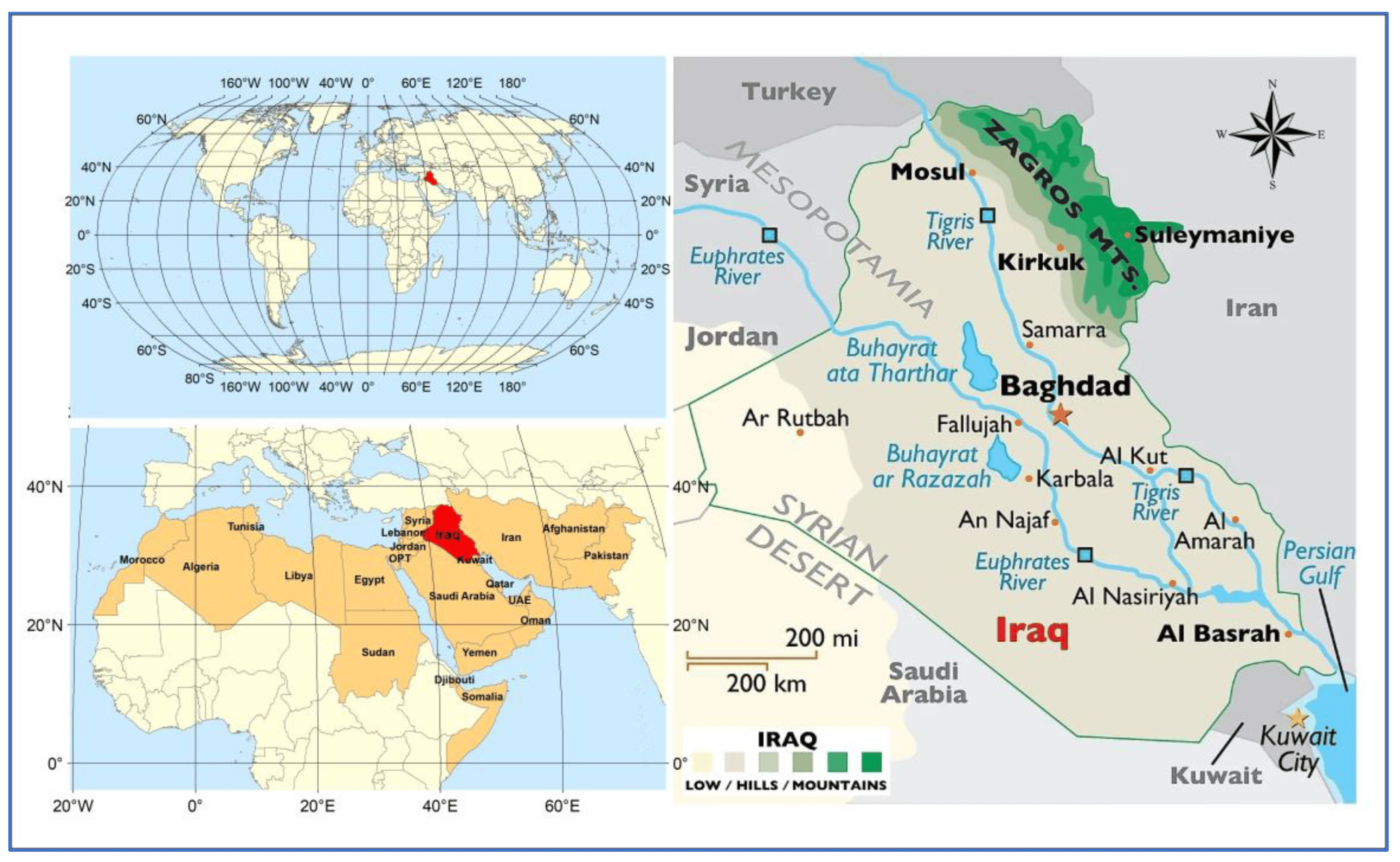
2. Data Collection, Methods, and Landforms

Since this study is a comprehensive review paper, part of the information has been derived from published research and studies and data from some specialized centers. Climatic data covering 60 years, from 1960 to 2020, and SDSs were frequently collected from the General Authority for Meteorological and Seismic Monitoring in Iraq. Carbon dioxide data were collected for the period from 1927 to 2020 from the Global Carbon Project. The Statistical Package for the Social Sciences (SPSS) computer application was used to analyze these data and give data analysis for descriptive and bivariate statistics, numerical result predictions, and predictions for identifying groups. As heavy minerals were separated using bromoform by [24,25] and identified using a reflected light microscope, the grain sizes and mineralogy of the SDSs were obtained from [26], which is based on [27]. The light minerals were petrographically identified and coupled with the XRD technique. Iraq is located in western Asia in the Middle East (Figure 1). The climate is heavily influenced by the topography, as Iraq has four main physiographic features—a mountain in the north, a desert in the west, a flood plain in the center that extends to the south containing marshes and wetlands, and a coastal environment near the Arabian Gulf delta [28]. Iraq has a varied topography, with the ground hardly rising above sea level in the extreme south and reaching 3600 m in the north. The physiographic landscape can be roughly divided into a rocky desert (west and southwest), a folded zone and steppes (north and northeastern) along the borders of Turkey and Iran, hills and plains (middle to south), and the marshy lowlands and delta of the Tigris and Euphrates (south) where the rivers drain into the Arabian Gulf. The Western and Southwestern Deserts are dry areas and part of the Syrian Desert [29], which also covers large parts of Syria, Jordan, and Saudi Arabia and is characterized by poor vegetation [30,31]. In the summer, Iraq’s climate is dry and hot, with daytime temperatures above 40 °C, with some days reaching 50 °C, and the relative humidity increases towards the Arabian Gulf [28]. Near-freezing temperatures are experienced. Dusty desert winds can blow for days throughout spring and summer and can even reach neighboring areas. Most precipitation occurs as rain or snow between November and April in the mountainous regions of the north and northeast. Winter temperatures here decline below 0 °C. The landscape becomes increasingly flat in the south, represented by the Tigris and Euphrates river delta [28]. The area is distinguished by its fertility, and flora is spread around the Tigris and Euphrates Rivers [32].

3. Results

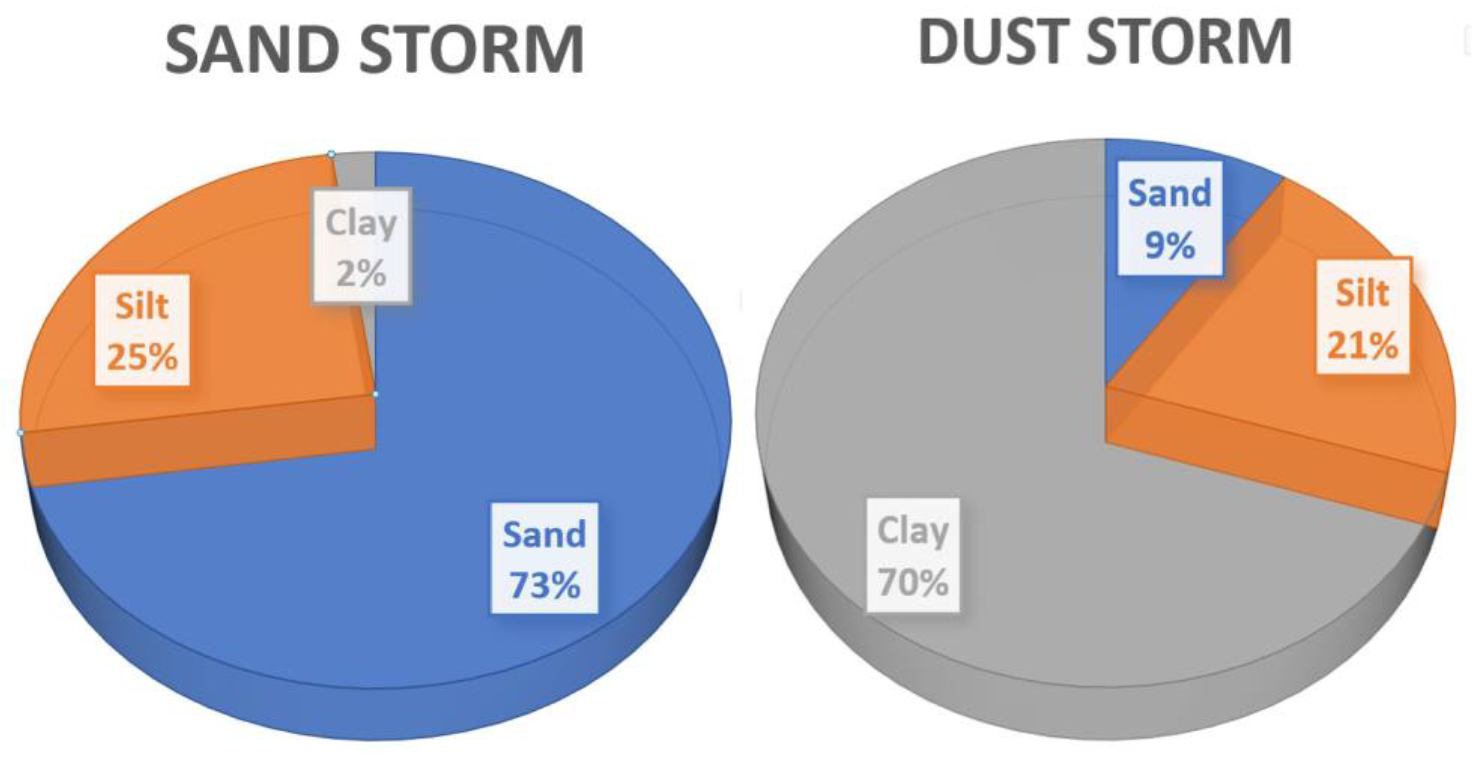
3.1. Particle Size and Composition of SDSs

The components of SDSs vary both minerally and chemically according to the source region and wind energy. The energy of the transport factor represented by the wind determines the size and weight of the particles transferred from the source area to the deposition area. The heavy particles are initially deposited, while the lighter particles are suspended and have a longer transmission distance. The residence time depends on the wind energy and the weight and shape of the particles. It is necessary to delve into the issues of mineralogical composition and grain size because of their close relationship with human health. SDSs have a large discrepancy in the distribution of grain sizes among sand, silt, and clay (Figure 2). The danger of dust storms (DSs) lies in the fact that they contain more fine particles, as they consist of 70% clay, while sand storms (SSs) contain only 2.1% of this particle size. Table 1 shows the mineral composition and grain size of selected samples from storms that have hit Iraq. Quartz and feldspar predominated in SSs and constituted an average of about 87% of the total mineral composition, while quartz, carbonates (calcite and dolomite), and gypsum predominated in dust storms, accounting for nearly 92%. There was also a share of heavy metals, which contributed 6.6% and 3.2% to SSs and DSs, respectively, including quartz (67.1, 49.2%), feldspar (20.9, 4.9%), calcite (5%, 38%), gypsum (0.4, 4.8%), dolomite (1.0, 0.8%), and heavy minerals (6.6, 3.2%).

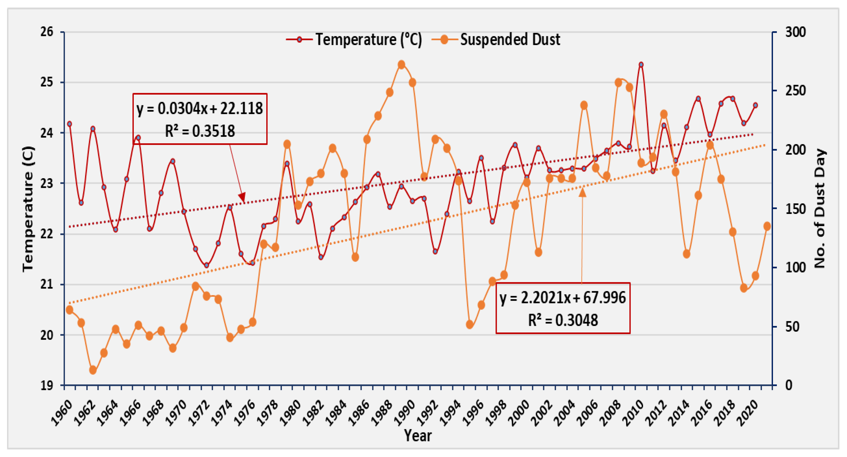
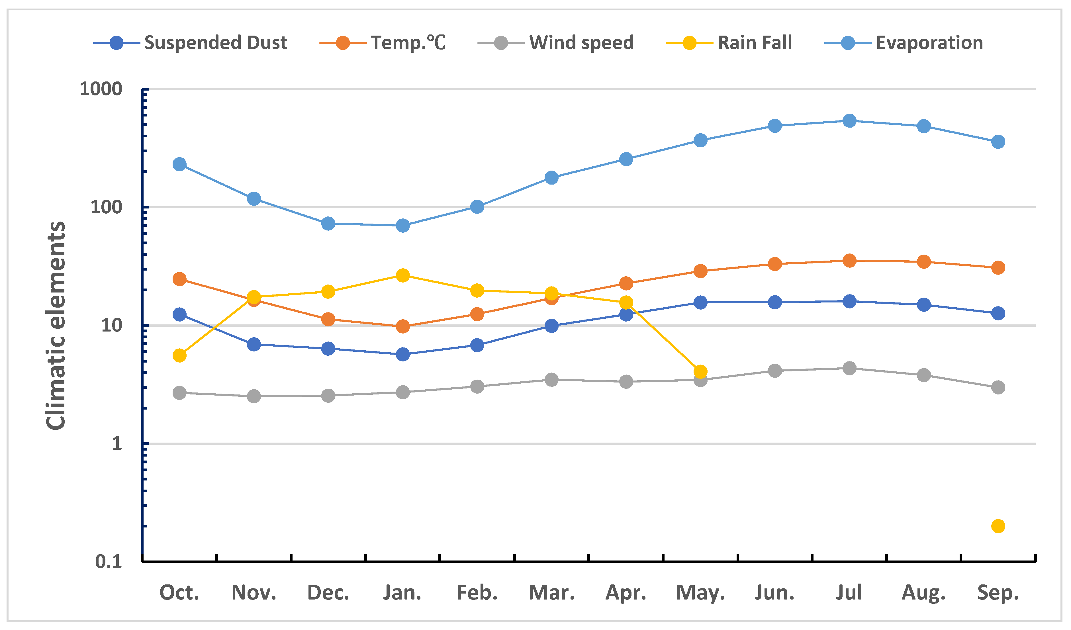
3.2. Effect of Temperature on SDS Blowing

The world is witnessing climate change, as temperatures have begun to increase in most countries of the world. Since Iraq is a semi-dryland country, it is exposed more often to SDSs, as the warming trends over drylands are twice as great as those over humid regions [33,34]. Climatic information shows that temperatures are steadily increasing in Iraq. The linear regressive curve shows an increase of 2 °C on average over sixty years, from 1960 to 2020 (Figure 3). The rise in temperature is associated with the emissions of carbon dioxide, with a direct relationship, and the results show the direct impact of each of these two variables (emissions of carbon dioxide and increase in warming) on the frequency of dust storms over Iraq. Accordingly, the number of dust storms increased from 75 to 200 times per year over 62 years (1960 to 2022), as shown in Figure 3. According to the CDIAC data, carbon dioxide is released from several sources, such as cement manufacturing, flaring, and the combustion of fossil fuels (solid, liquid, and gas). Burning liquid fuel produced the maximum carbon dioxide emissions between 1957 and 2007, while burning gas and operating cement plants produced the least. One of the causes of global warming is carbon dioxide, which is known to be massively emitted all over the world [28]. The annual carbon dioxide emission levels in Iraq for nearly a century from 1927 to 2020 are displayed in Figure 4a, and the per capita emissions are displayed in Figure 4b. These emissions are consistent with population growth, as the population of Iraq was 2,968,054 individuals in 1927, 4,816,185 in 1947, 6,536,109 in 1957, 8,261,527 in 1967, 11,479,000 in 1977, 16,335,199 in 1987, almost 20 million in 1997, and the population of Iraq now exceeds 35 million [35]. Various source types of fuel participate in CO2 emissions, and they are mostly emitted from oil, flaring, gas, cement, and coal for 93 years from 1927 to 2020, according to the analysis (Figure 4c).

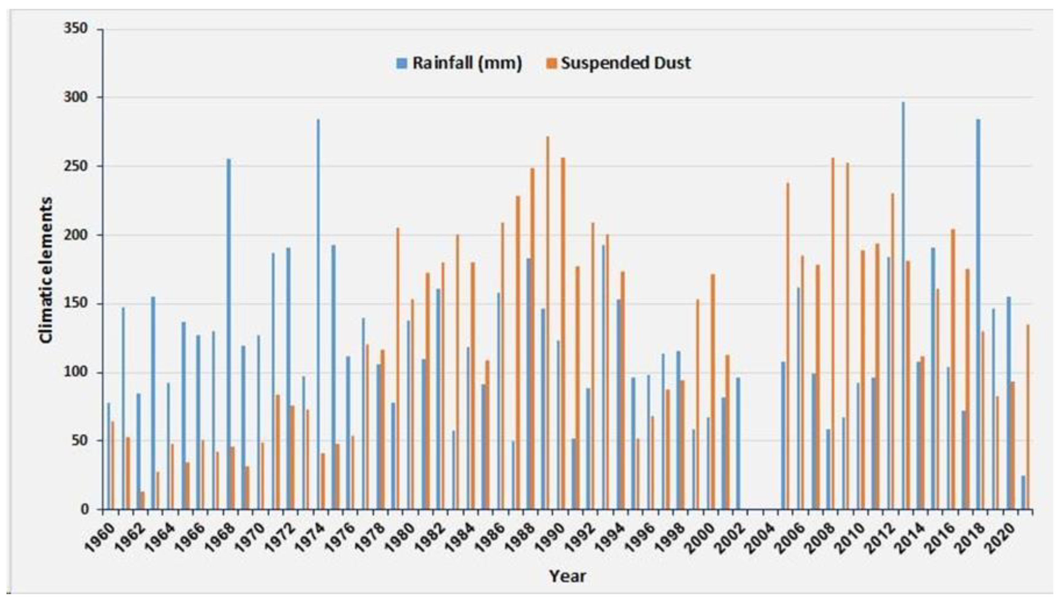
3.3. Precipitation, Wind Speed, and DSSs

The countries of Asia vary in climatic terms; Figure 5 shows the amount of rain in each country. Precipitation is concentrated in the southeastern part of Asia and decreases towards the west. The United Nations Food and Agriculture Organization (FAO) estimates that Iraq receives between 100 and 250 mm of precipitation yearly. A long-term prediction model predicted monthly rainfall rates and how the effect of SDSs in Iraq has resulted in lower rainfall in recent years compared to long-term means. Comparing the rainfall rate with the dusty days in Iraq for the long term, from 1960 to 2021, showed a significant negative correlation between increasing the frequency of SDSs with a decrease in rainfall over the past 61 years (1960–2021) (Figure 6 and Figure 7). The monthly model analysis for 60 years (1960–2020) displays how the suspended dust is correlated to the various climatic elements represented by rainfall, temperature, evaporation, and wind speed (Figure 8). A noticeable increase in wind speed rates was recorded from February to August, which is closely related to the frequency of DSs. Several physical factors are key influences on wind erosion [36]. Soil type particle composition, density, soil moisture, vegetation cover and its distribution, and landforms such as slope, roughness, and ridges are key factors in soil weathering and dust emissions [37,38]. The monthly wind speed averages in Iraq from 1960 to 2020, along with the wind direction, are illustrated in Figure 9. The direction of the wind indicates the source of SDSs [26,38,39,40]. The prevailing trend inferred from the 60-year wind speed analysis is from west to northwest. In applying remote sensing techniques, important regional sources have been determined, such as the SDNA, the Syrian Desert, the Turkish Anatolian plateau, and sites from the Arabian Peninsula, as well as local sites within Iraq.
DSSs during the winter are associated with southeast winds due to synoptic low-pressure systems and northwest winds after passing cold fronts. The latter wind is often referred to as the north of winter. In the spring (April–June), Iraq transitions from winter conditions to summer heat. Latitudinal cyclones are common in early spring but decrease towards the end of the season. In summer (July–September), Iraq is under thermal influence extending northwest of Pakistan and associated with the Asian summer monsoon. The influences of the Mediterranean with the thermal dip over Pakistan lead to northwesterly winds blowing over Iraq, referred to as the dry north. Typically, winds blow at 10–15 knots, although they might reach 25 knots for numerous hours or even days. Storms of 40 to 50 knots are frequent during these persistent winds [42]. In the majority of Iraq’s regions, there are frequent alterations in the wind strength throughout the day, with the nighttime winds being generally less severe [42]. Winter conditions start to return in the fall (October through December). The wind remains northwest but weakens, dropping to 5–10 knots. Rainfall resumes, mainly in the form of showers, beginning in October and gradually increasing during winter [42]. Dust sources are local and regional. Some dust source points are within Iraq and others are in neighboring countries, such as Syria, the Anatolian Plateau in Turkey, and countries as far away as the SDNA. The Western Desert, especially the southern part of it, and the alluvial plains in Iraq, including the marshes, are sources of dust. This indicates that northwesterly winds are particularly effective in generating DSs over Iraq. It has been estimated that approximately 50% of ADPs in the troposphere are composed of minerals mainly derived from deserts and their surroundings [43]. Bacteria and heavy metals are both capable of long-distance transportation via ADPs. Aerosols, particularly those carried by DSs, have the potential to be transported globally and could significantly affect the ecosystem and climate [44]. Aerosols are essential in the transport and deposition of atmospheric pollutants [45].

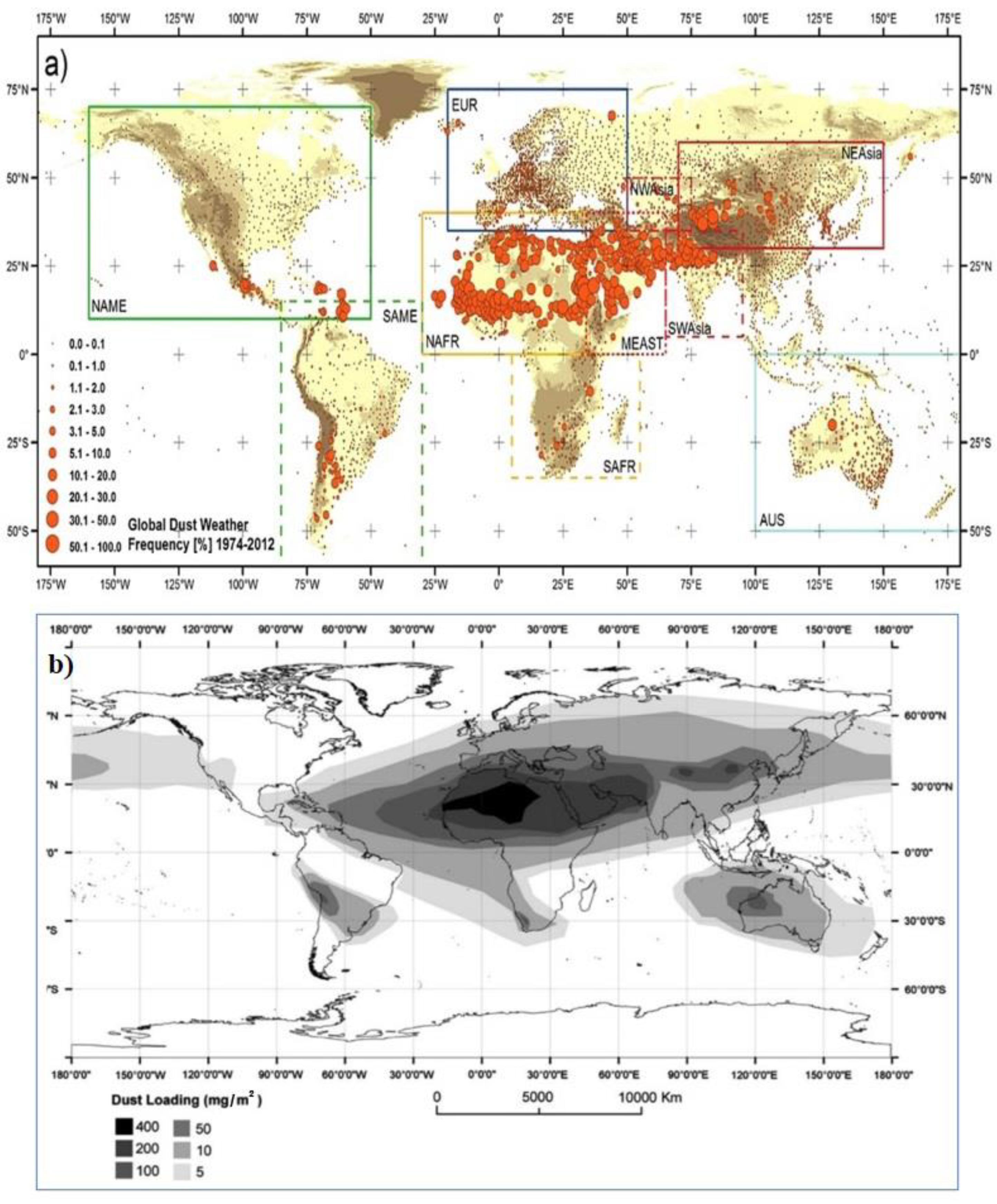
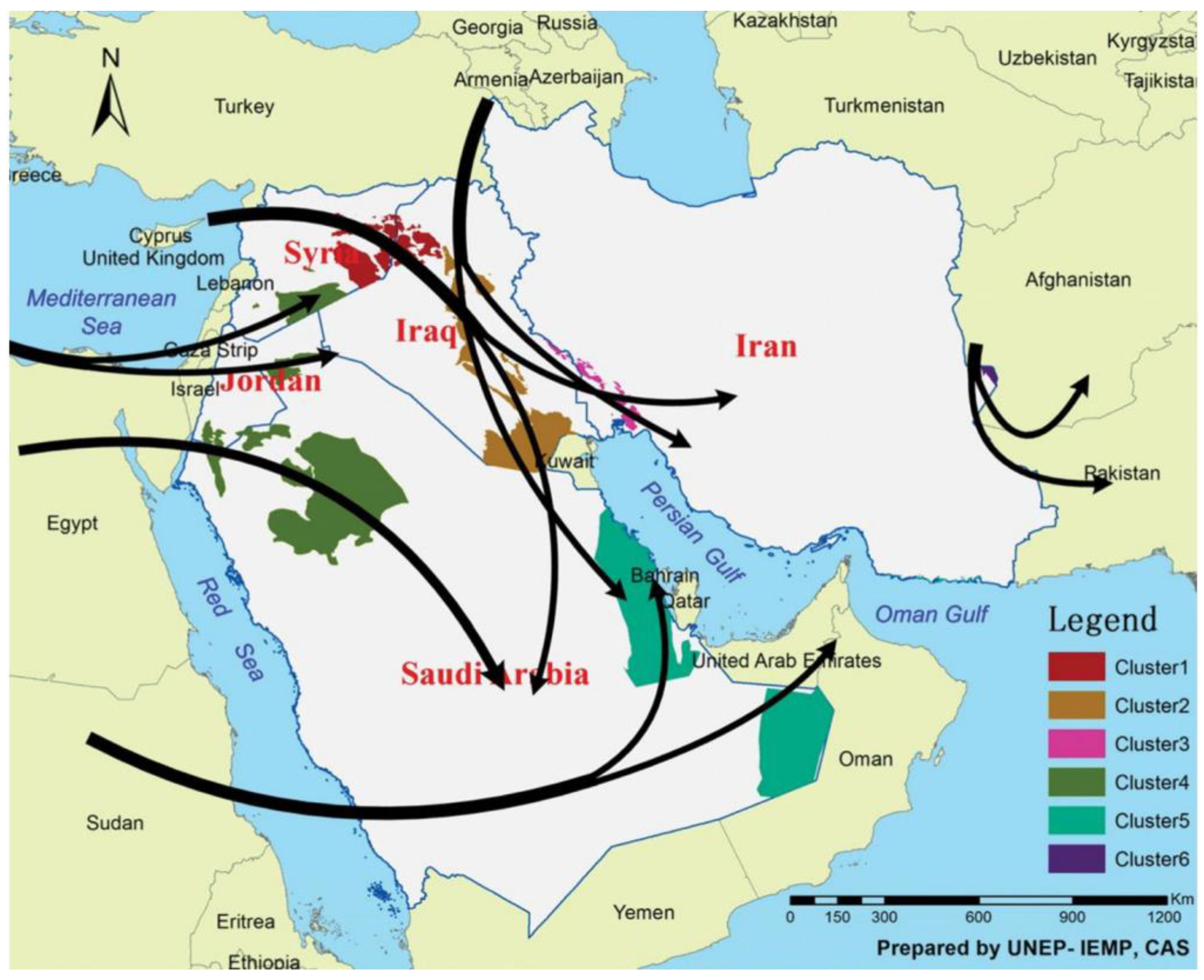
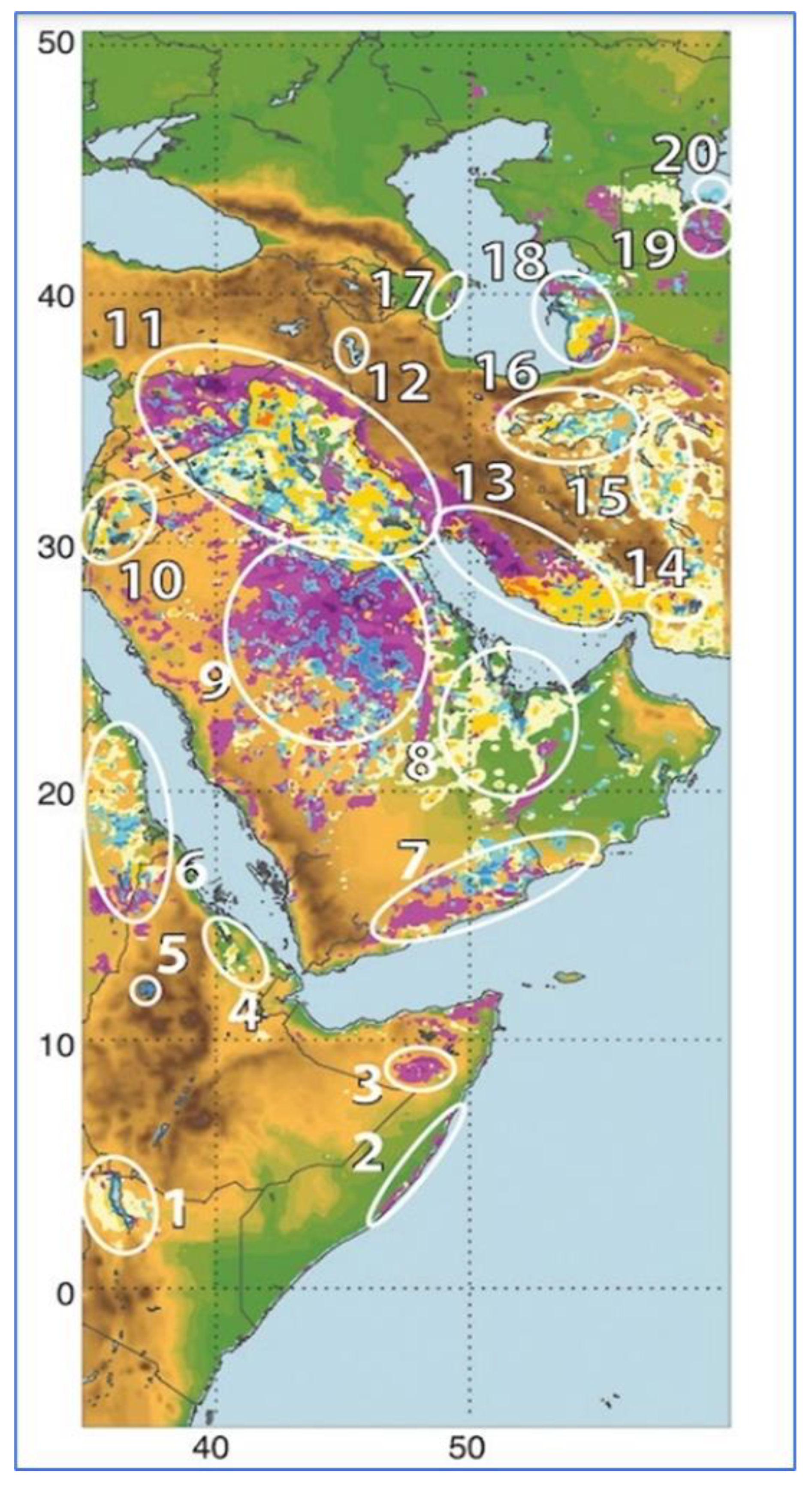
3.4. Dust Sources and Hot Spots

The MENA area is the dustiest place on earth. The Arabian Peninsula, Central Asia, Western and Eastern China, North and South America, and Australia all contribute to the total global output of SDSs. On the African continent, SDSs are a visible natural occurrence [46], supplying minerals to the Mediterranean and Black Seas via the Saharan DSs [47]. A global pattern of dust frequency is displayed in Figure 10a. The global atmospheric dust load is of a heterogeneous distribution, as it shows hot spots sourced from Africa (Figure 10b). Dust sources are of three origins—hydrologic, natural, and anthropogenic. The hydrologic source is related to different water features; the natural source is the dust that is released when less than 30% of the land is utilized; the anthropogenic sources are when more than 30% of the land is used [48]. Around the world, natural sources of dust account for 75% of emissions, with anthropogenic sources producing the remaining 25% [48]. The global dust emissions consist of 55% from NA and only 8% from anthropogenic sources. Worldwide, 31% of the sources of hydrologic dust are ephemeral water bodies, only 15% are naturally occurring, and the remaining 85% are anthropogenic [49]. Figure 11 shows the paths and hotspots of DSs in the MENA.
The vast majority of DSs in the Middle East come from a complex mixture of both natural and anthropogenic sources. The sources of dust sites in Saudi Arabia (site 9) are strikingly clustered around dry riverbeds (Figure 12). Dust from the area between the Tigris and Euphrates Rivers has a local natural source in Iraq, while in Syria, it is classified as anthropogenic. Dust sources in Jordan are classified as anthropogenic and hydrological, clustering along the Jordan River (site 10 in Figure 12). In Iran, lakes and large saline deserts are among the most prominent natural dust foci, except for dust sources in the northwestern part, which are anthropogenic.

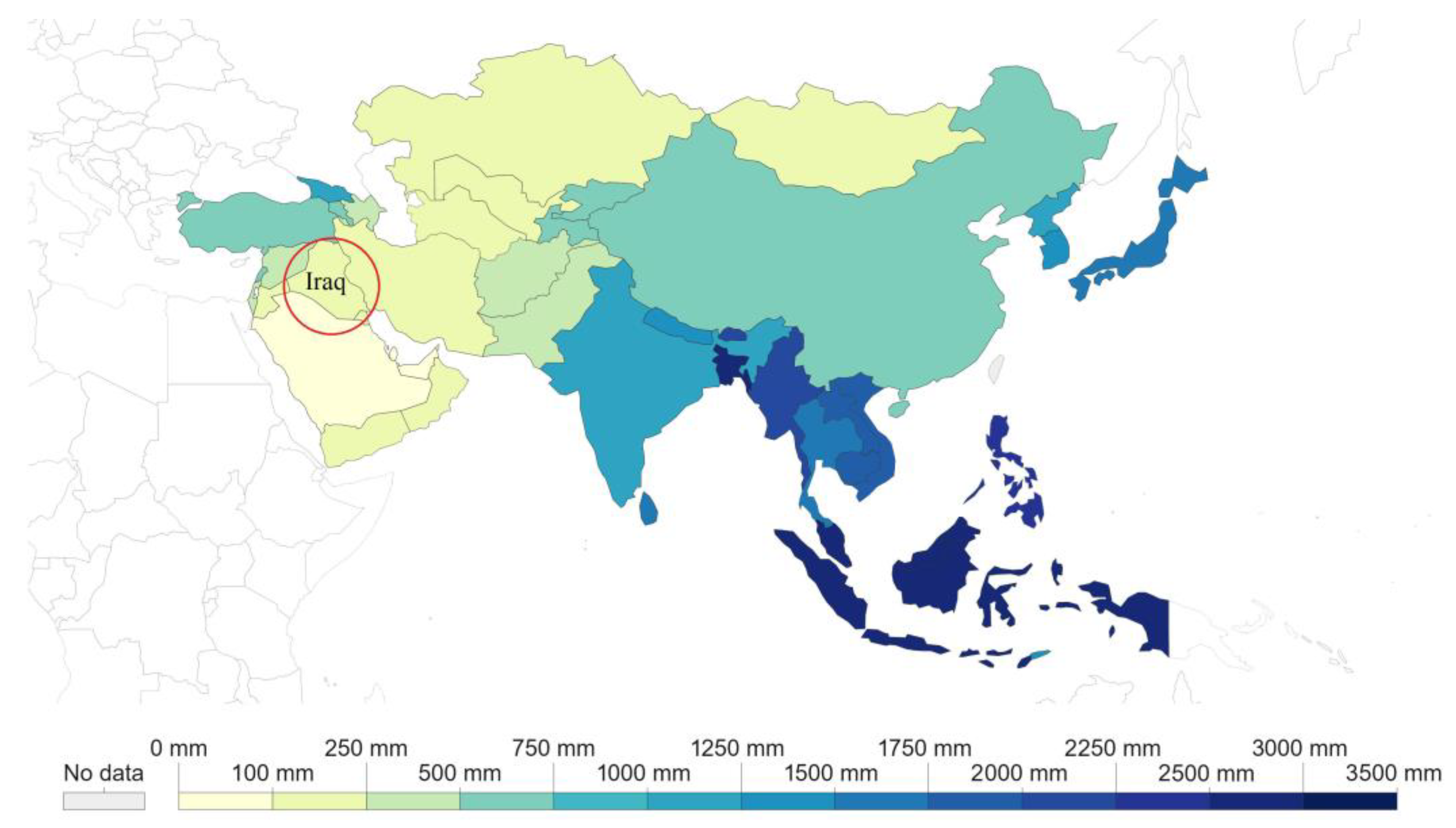
3.5. Environmental, Health, Social, and Economic Impacts of SDSs

The average cost of dust-related welfare losses in MENA is USD 150 billion, or more than 2.5% of the gross domestic product, with an estimated global cost of USD 3.6 trillion. SDSs in the MENA cause about USD 13 billion in lost gross domestic product annually. In Iraq, vast lands have vanished with the intensification of desertification, and 122 DSs and 283 dusty days were recorded in one year. Within the next decade, the number can increase to about 300 dust events per year. SDSs deposited 6.9 million tons on Iraq’s land on 11 April 2008 [26]. Approximately 8 million tons of fine soil particles leave Africa annually to form DSs. For example, up to 330,000 tons of sand fell on the city of Beijing in one night in 2006 [54]. One sandstorm deposited up to 10 million tons of dust particles over Great Britain at once [55]. SDSs contribute to poor air quality, and seven million people die according to estimates by the WHO. Up to 250,000 people contract potentially fatal diseases each year in Central Africa, and it is thought that SDSs are to blame for the spread of the meningitis viruses there. SDSs harm food security by destroying agricultural infrastructure, reducing the productivity of fertile topsoil, and directly affecting production. SDSs affect household income sharply, as millions of people cannot get to work due to a limit to their range of vision. They are risk factors for chronic diseases, such as lung cancer, acute lower respiratory infections, and cardiovascular and respiratory diseases that cause premature death [56]. Since 1900, Great Britain has experienced DS disasters 17 times. SDSs prevent coral reefs from receiving sunlight, and they spawn toxic algal blooms due to adding fine particles to water. Both continental and maritime ecosystems can obtain micronutrients from surface dust deposits. Dust transports of iron and phosphorus are known for helping marine biomass production in areas of the oceans suffering from a scarcity of these elements, and it is believed that SDNA dust fertilizes the Amazon rainforest. Despite these advantages, the regional climatic extremes, including drought and heat waves, are ecologically and economically relevant for agriculture and forestry [57,58,59,60]. Drought and heat affect plant health and productivity through the climatic challenge faced by farmers and decision-makers [61]. These effects will be evident in the coming decades because these two factors are related to the extreme weather events expected in the context of global climate change [62]. Dust particle accumulation can stunt plant development, dry up leaves, and harm harvests. It can block sunlight from reaching the sea floor, impacting the marine life cycle. Dust also has several detrimental effects on agriculture, including lowering crop yields by burying seedlings, causing plant tissue loss, lowering photosynthetic activity, and accelerating soil erosion. A few indirect effects of dust deposition include overflowing irrigation canals, blocking travel lanes, and degrading the water quality of rivers and streams. SDSs have had a direct impact on the weather, causing a 6 °C drop in temperature over the course of 8 h [26]. They have also been particularly harmful to human respiratory systems, increasing the number of fatalities and hospital admissions. According to [63], many suspended particulate matter components are respiratory irritants and may contain contaminants, toxins, heavy metals, salt, sulfur, pesticides, bacteria, and pollens; they provide poor air quality. Regarding DSs, they are 70% clay and have a size of less than 0.0039 mm [26]. Because samples from DSs cannot establish the presence of fibrous minerals, they are not carcinogenic. In addition, substances that are adsorbed on the surface of ADPs or suspended particulate matter may include carcinogens or mutagens [63]. PM2.5 stands for particle size categories that are likely to enter the lungs after being inhaled [63]. As a result of its penetration into the lungs, the clay fraction is harmful to human health. ADPs present significant risks to human health, and the size of the dust particles is the main factor for potential risks to human health. The WHO has determined that sizes >10 μm are not inhaled, but they are harmful to the skin and eyes and can cause conjunctivitis. As for particles less than 10 μm in size, they are respirable, and therefore, cause respiratory disorders such as asthma, tracheitis, pneumonia, allergic rhinitis, and silicosis. On the other hand, fine particles can penetrate the respiratory system and enter the bloodstream, causing cardiovascular disorders. Exposure to dust particles in a 2014 case study caused the premature deaths of approximately 400,000 people [64]. ADPs are fine solid particles that are added to the atmosphere due to human activities (mining, quarrying, blasting, coal dust, crystalline silica dust, etc.), or natural events (volcanoes, DSs, forest burning, and sea spray) [65]. These minute particles cause lung diseases that may lead to the loss of life. Inhalable dust pollutants (100 µ) accumulate in the lungs. ADPs of PM10 form a visible dust that is considered to be the least harmful to the human body due to self-cleaning mechanisms in the lungs, although some dust particles, such as silica, are dangerous in this particle size category. PM10 can irritate your eyes, nose, and throat. ADPs of PM 2.5 are invisible to the naked eye and enter the alveoli, reducing the efficiency of the lungs to breathe. The data of annual PM100 concentration and deaths per year in MENA countries is presented in Table 2. Dust particles with a size of less than 2.5 microns are more dangerous to health. They tend to lodge in the bronchi, bronchioles, and alveoli and even enter the bloodstream, resulting in irreversible damage to the lungs, which leads to lung cancer, silicosis, and black lung disease. Long-term exposure to fine particles severely affects public health, as it increases the proportion of deaths related to cardiovascular diseases and exacerbates respiratory problems, such as asthma or chronic bronchitis. As for its short-term health effects, it is represented by shortness of breath, irritation of the membranes of the eyes, nose, and throat, and sneezing. They increase environmental hazards. The effects of reduced vision brought on by ADPs also extend to ground and air transportation. Poor visibility can cause landings to be diverted and takeoffs to be delayed, which is dangerous for aircraft. Dust can also scour the surfaces of aircraft and harm their engines. Solar power plants’ output can be affected by dust, particularly those that depend on direct solar radiation. Solar panel dust buildup is a major concern for plant operators. It takes time and effort to keep solar collectors dust-free and prevent particulates from obstructing incoming energy. Dust affects the economy by causing harm to facilities, including highways and infrastructures. Costs are associated with removing sand from roads, cleaning up infiltrating dust within structures, accidents, material loss, and airline and vehicle traffic delays. The effects of ADPs operate similarly to global warming, as part of the solar radiation that enters the Earth’s atmosphere is trapped and the rest is scattered, reducing the amount reaching the surface. Additionally, they serve to scatter long-wave radiation in all directions by absorbing it from the surface. The size, shape, mineral content, and chemical composition of the particles all play major roles in how well ADPs can absorb solar energy. The MENA has some of the highest average PM2.5 and PM10 concentrations worldwide [66]. Iraqi, Egyptian, and Pakistani communities in the MENA experience disproportionately higher rates of premature death; up to 30,000 deaths may be linked to poor air quality.

3.6. Dust Reasons and Mitigation Methods

Natural and anthropogenic sources are the main reasons for induced dust. Wind erosion is the main natural driver of SDSs, which is also dependent on other climate and land characteristics [36]. SDSs have serious consequences for society, the economy, and the environment at local, regional, and worldwide scales. They are caused by three major factors: high winds, a lack of vegetation, and a lack of rainfall. The environmental and health risks posed by such storms cannot be eliminated, but their influence can be mitigated by implementing proper steps. In dry and semi-arid areas, DSs are a frequent meteorological hazard, typically brought on by cyclones or thunderstorms that have substantial pressure gradients that increase wind speed across large areas. The troposphere contains 40% of aerosols as wind-eroded dust [67]. The dry regions of Northern Africa, the Arabian Peninsula, Central Asia, and China are the main suppliers of dust particles; South Africa, Australia, and North America all contribute significantly too. Estimates of the annual global emissions of dust primarily vary from one to three gigatons. The low-pressure systems are primarily responsible for the DSs, and at least 13 pressure systems have affected the development of DSs in the studied area [68]. Human-induced factors contribute indirectly to SDSs, for instance, population increase, economic globalization, ecosystem management failure, unsustainable policy, land overuse, agricultural land use changed for urban development and waste disposal, using technology harmful to the atmosphere, migration to fragile lands, climate change and global warming, war, and political disorder. The Middle East region is predicted to be responsible for 24% of all worldwide dust emissions [69]. Major events have the power to spread SDSs over enormous distances, often crossing international borders, so that their effects spread beyond the regions from where they originate. Consequently, the problem can only be solved by the concerted efforts of several countries, not the state itself. It was found that carbon dioxide is a factor that contributes to climate change, the frequency of dust storms, and the temperature, which has increased in Iraq at a rate of about 5 °C every 45 years. [28]. By working to reduce air pollution levels and using early warning systems, countries can reduce the risks of strokes, heart disease, lung cancer, and asthma. Early warning systems allow people to take cover, close doors, and clear the streets, reducing the number of traffic accidents. They also allow farmers to bring in livestock and farm equipment and harvest all or part of the crop before the storm hits. Regional and international cooperation among countries is critical in tackling the underlying causes of SDSs and recovering ecosystems. When dealing with health emergencies, policymakers can use data from improved monitoring systems to assess whether illness outbreaks are the result of carried sand and dust or human transit. During poor land management, wind erosion is exacerbated by human activities that raise the soil, including tilling, grazing, and erosion. Poor land management practices, in addition to periods of drought, lead to erosion of the topsoil and blow DSs at a large scale. Such sources are possible to mitigate. If the dust is of natural origin, the mitigation of naturally sourced SDSs is achievable by stabilizing the surface and placing fences when blowing SDSs interfere with human operations. On a broad scale, however, neither is practicable nor desirable. Globally, the possibility for source mitigation is limited, making effect mitigation even more important. Mitigation requires monitoring, modeling, forecasting, and early warning systems that facilitate actions that can be taken in the short term. Forecasting DSs helps prepare for storms and reduces damage, such as providing additional equipment for hospital emergency rooms related to the respiratory system, determining when crops are planted and harvested, protecting livestock, arranging and resetting solar energy generation schedules, and scheduling maintenance and cleaning solar panels. Modeling and forecasting provide a good possibility for mitigating the effects of SDSs and require a great effort to design more intelligent models that predict global and regional dust. Dust models mimic the atmospheric dust cycle using mathematical and numerical methodologies, including how dust is emitted, transported, and deposited and how it interacts with solar radiation and clouds. Input parameters, such as the surface, soil, and meteorological features, can be used to calculate DS forecasts. Whatever the case, the input will be subject to some kind of error, including those related to spatio-temporal variations. According to the previous models, the relationship between wind and dust is non-linear and may lead to errors. The challenges ahead require the explicit treatment of convection currents, which cause sand and dust to fly upwards in arid and semi-arid regions. It is preferable to use numerical simulations of dust emissions in conjunction with actual satellite aerosol data to obtain the best forecast performance.

3.7. Desert Afforestation and Drought-Tolerant Plant Adaption

Annual global dust emissions have increased by 25 to 50% over the last century due to a combination of land use and climate change [50]. Protective belts provide the opportunity for soil stabilization in one country or between countries. Satellite information on climatic conditions can be used to determine the locations of dry soil that are expected to be sources of dust. One plan is to grow locally adapted plants with the development of barriers made of trees and shrubs to protect the soil erosion. It is possible to resort to advanced and quick strategies, such as employing the capabilities of drones to provide up-to-date information on the state of the soil, and scattering seeds in areas to be planted, with early monitoring through what is provided by the Regional Dust Center of the World Meteorological Organization, as it predicts the concentration of dust and the direction of its movements for 72 h. It is recommended to plant strong and attractive shrubs, which are the best plants for erosion control because they have an effective root system for soil stabilization. Many plant species are adapted to live in a desert environment and are resistant to drought. Xerophytes are a group of plants that have adapted to surviving in deserts’ wide range of temperatures and need little water [70]. A common example of a xerophyte is the Joshua tree, which belongs to the genus Yucca and is famous for its ability to survive in the desert [71]. This shrub produces a thick resin from its glandular trichomes that encase the leaves of the shrub, which helps prevent water loss by acting as a sealing agent [72]. Cacti, like the prickly pear, have thick waxy skin with few stomata, prevent water loss, and are an example of the adaptation of desert plants. Lamb’s ear is a medium-sized ground-covering plant with leaves borne on a long stalk and purple flowers that bloom in late spring, attracting butterflies, hummingbirds, bees, and other pollinators. Soft hair covers its leaves, which helps it withstand drought. It can spread seeds from the flowers, covering the ground more quickly. Silverberry (Elaeagnus pungent) is a drought-tolerant shrub that grows very quickly at 8 cm per year, creating barriers and windbreaks when it reaches a height of 30 cm [73]. The plant has small white flowers with a pleasant fragrance. The desert bird of paradise (Caesalpinia gilliesii) is a desert plant with red and yellow flowers that bring hummingbirds and pollinators, and it has a high drought tolerance [74]. Heavenly bamboo is a drought-tolerant plant that gives a stunning view through all seasons. The leaves of this plant change colors in every season of the year and do not fall in the fall season. Rosemary is a strong shrub that is grown as a ground cover and prefers to live in the high desert [75]. It tolerates drought and gives elegance to the place, as it has light blue fragrant flowers. Copying ancient techniques for desert restoration is very attractive and sustainable, such as using water from the air instead of expensive electricity and energy.

4. Conclusions

The findings of the current study can be summarized as follows:
  • There has been a noticeable rise in annual global dust emissions due to a combination of changes in land use and climate over the past century. The production of SDSs worldwide is influenced by the SDNA, South Africa, Arabia, Central Asia, West and East China, North and South America, and Australia.
  • Massive regional dust plumes originate from the SDNA, which is the dustiest region in the world, east of the Syrian Desert, Anatolia in Turkey, the Arabian Peninsula, and some local point sources within Iraq.
  • These sand and dust loads are characterized by clay-sized particles that make up only 2% of the components of SSs, but up to 70% of those of DSs, which consist mainly of quartz, followed by feldspar, calcite, dolomite, and gypsum. In comparison, DSs consist mainly of calcite, followed by feldspar, gypsum, and dolomite. SSs contain more heavy minerals than DSs.
  • The regions that are the most common sources of DSs in the ME are the SDNA, and the dry lands of Saudi Arabia, Syria, and Jordan, as indicated by the heavy mineral groups and satellite images.
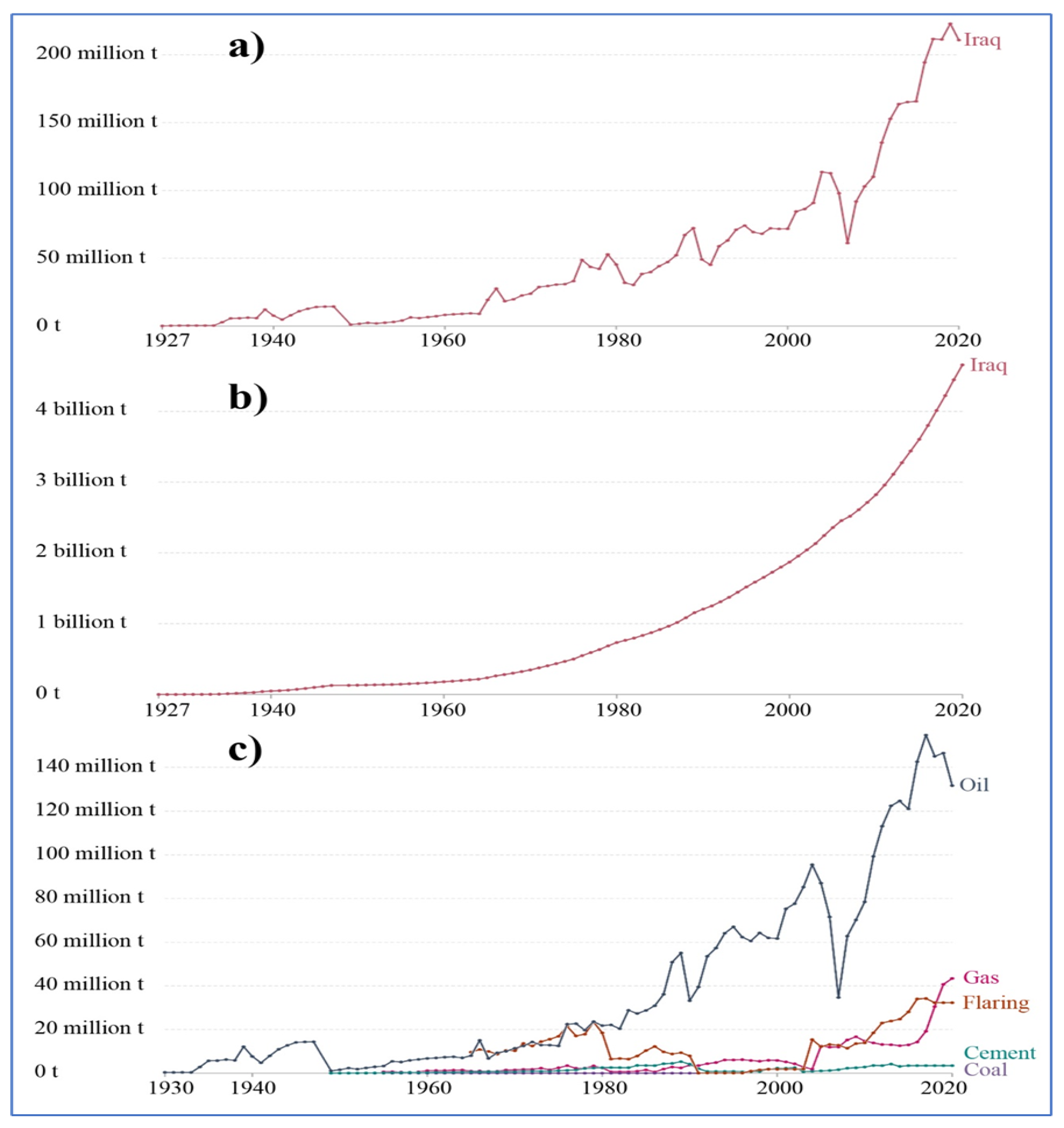
  • The frequency of blowing DSs is related to the wind speed and its direction, as the prevailing wind directions indicate that most of the dust sources come from the west and northwest, which indicates the major role of the African continent in supplying the Middle East with dust. Drought in Iraq has created a suitable atmosphere for DSs. The dust frequency in Iraq increased during the period from 1960 to 2022 from 75 to 200 times per year and was associated with the temperature, which increased by 2 °C in response to carbon dioxide emissions, which were less than 50 tons in 1960 and reached more than 220 million tons in 2022. On the other hand, the decrease in rainfall over the past 61 years (1960 to 2021) indicates a negative relationship with the increasing frequency of SDSs.
  • Land degradation caused by human activity and natural causes leads to wind erosion, which contributes to the increased frequency of SDSs [76]. Soil stabilization is one of the most important measures to mitigate the negative health and environmental and economic impacts of SDSs, which are mediated by afforestation by planting plants that adapt to the environment and resist drought in the desert.
  • Advanced strategies should be adopted, including a drone technology strategy, which is an ideal method for agriculture, as seeds can be sown over vast areas within a short time, and cities fenced with tree belts. These strategies should be applied in conjunction with addressing the causes of drought, such as reducing carbon emissions and taking care of land uses according to a satisfactory environmental system that prevents the encroachment of agricultural lands, reducing green lands.
  • Ultimately, this paper recommends a detailed study of the dust vertical profile in the atmosphere and clarifies how each scale affects public health and the environment.

Funding

This research received no external funding.

Institutional Review Board Statement

Not applicable.

Informed Consent Statement

Not applicable.

Data Availability Statement

The data presented in this study are available upon request from the corresponding author.

Acknowledgments

The author is very grateful to the staff working in the General Authority for Meteorology and Seismic Monitoring for providing the climatic data necessary to complete this research.

Conflicts of Interest

The author declare that he has no known competing financial interest or personal relationships that could have appeared to influence the work reported in this paper.

References

  1. Al-Dabbas, M.; Abbas, M.A.; Al-Khafaji, R. The mineralogical and micro-organisms effects of regional dust storms over Middle East region. Int. J. Water Resour. Arid. Environ. 2011, 1, 129–141. [Google Scholar]
  2. Al-Dabbas, M.A.; Ayad, A.M.; Al-Khafaji, R.M. Dust storms loads analyses-Iraq. Arab. J. Geosci. 2012, 5, 121–131. [Google Scholar] [CrossRef]
  3. Guo, Y.T.; Zhang, J.; Wang, S.G.; She, F.; Li, X. Long-term characterization of major water-soluble inorganic ions in PM10 in coastal site on the Japan Sea. J. Atmos. Chem. 2011, 68, 299–316. [Google Scholar] [CrossRef]
  4. Youlin, Y.; Squires, V.; Qi, L. Global Alarm: Dust and Sandstorms from the World’s Drylands; United Nations: New York, NY, USA, 2022. [Google Scholar]
  5. Scherr, S.J. Soil Degradation: A Threat to Developing-Country Food Security by 2020? International Food Policy Research Institute: Washington, DC, USA, 1999; Volume 27. [Google Scholar]
  6. Sivakumar, M.V. Impacts of sand storms/dust storms on agriculture. In Natural Disasters and Extreme Events in Agriculture; Springer: Berlin/Heidelberg, Germany, 2005; pp. 159–177. [Google Scholar]
  7. Zoljoodi, M.; Didevarasl, A.; Saadatabadi, A.R. Dust events in the western parts of Iran and the relationship with drought expansion over the dust-source areas in Iraq and Syria. Atmos. Clim. Sci. 2013, 3, 33894. [Google Scholar] [CrossRef]
  8. Prospero, J.M.; Ginoux, P.; Torres, O.; Nicholson, S.E.; Gill, T.E. Environmental characterization of global sources of atmospheric soil dust identified with the Nimbus 7 Total Ozone Mapping Spectrometer (TOMS) absorbing aerosol product. Rev. Geophys. 2002, 40, 2-1–2-31. [Google Scholar] [CrossRef]
  9. Swap, R.; Ulanski, S.; Cobbett, M.; Garstang, M. Temporal and spatial characteristics of Saharan dust outbreaks. J. Geophys. Res. Atmos. 1996, 101, 4205–4220. [Google Scholar] [CrossRef]
  10. Meng, Z.; Lu, B. Dust events as a risk factor for daily hospitalization for respiratory and cardiovascular diseases in Minqin, China. Atmos. Environ. 2007, 41, 7048–7058. [Google Scholar] [CrossRef]
  11. Guo, Z.; Huang, N.; Dong, Z.; Van Pelt, R.S.; Zobeck, T.M. Wind erosion induced soil degradation in Northern China: Status, measures and perspective. Sustainability 2014, 6, 8951–8966. [Google Scholar] [CrossRef] [Green Version]
  12. Huang, X.; Zhao, H.; Xu, B. Wind erosion on field in a semiarid area of China. In Proceedings of the International Symposium on Wind Erosion, Manhattan, KS, USA, 3–5 June 1997; Volume 50. [Google Scholar]
  13. UNDRR. Hazard Definition and Classification Review; UNDRR and ISC: Geneva, Switzerland, 2020. [Google Scholar]
  14. Fu, C.; Diaz, H.F.; Dong, D.; Fletcher, J.O. Changes in atmospheric circulation over Northern Hemisphere oceans associated with the rapid warming of the 1920s. Int. J. Climatol. 1999, 19, 581–606. [Google Scholar] [CrossRef]
  15. Barlow, M.; Cullen, H.; Lyon, B. Drought in central and southwest Asia: La Nina, the warm pool, and Indian Ocean 15 precipitation. J. Clim. 2002, 15, 697–700. [Google Scholar] [CrossRef]
  16. Dai, A.; Trenberth, K.E.; Qian, T. A global dataset of Palmer Drought Severity Index for 1870–2002: Relationship with soil moisture and effects of surface warming. J. Hydrometeorol. 2004, 5, 1117–1130. [Google Scholar] [CrossRef]
  17. Lotsch, A.; Friedl, M.A.; Anderson, B.T.; Tucker, C.J. Response of terrestrial ecosystems to recent Northern Hemispheric 30 drought. Geophys. Res. Lett. 2005, 32, L06705. [Google Scholar] [CrossRef] [Green Version]
  18. Orlovsky, L.; Tolkacheva, G.; Orlovsky, N.; Mamedov, B. Dust storms as a factor of atmospheric air pollution in the Aral Sea basin. WIT Trans. Ecol. Environ. 2004, 74, 10. [Google Scholar]
  19. Awadh, S.M. A preliminary assessment of the geochemical factors affecting groundwater and surface water quality around the rural communities in Al-Anbar, Western Desert of Iraq. Environ. Earth Sci. 2018, 77, 83. [Google Scholar] [CrossRef]
  20. Awadh, S.M.; Al-Sulttani, A.H.; Yaseen, Z.M. Temporal dynamic drought interpretation of Sawa Lake: Case study located at the Southern Iraqi region. Nat. Hazards 2022, 112, 619–638. [Google Scholar] [CrossRef]
  21. Awadh, S.M.; Al-Mimar, H.; Yaseen, Z.M. Groundwater availability and water demand sustainability over the upper mega aquifers of Arabian Peninsula and west region of Iraq. Environ. Dev. Sustain. 2021, 23, 1–21. [Google Scholar] [CrossRef]
  22. Middleton, N.; Kashani, S.S.; Attarchi, S.; Rahnama, M.; Mosalman, S.T. Synoptic causes and socio-economic consequences of a severe dust storm in the Middle East. Atmosphere 2021, 12, 1435. [Google Scholar] [CrossRef]
  23. Shuker, Z. Dust Storms and Climate Change: A Crisis for the Iraqi Economy, and the Need for Multilateral Solutions; The Institute of Regional and International Studies: Islamabad, Iraq, 2022. [Google Scholar]
  24. Grosz, A.E.; Berquist, C.R.; Fischler, C.T. A procedure for assessing heavy-mineral resources potential of the continental shelf sediments. In Heavy Mineral Studies. Virginia Inner Continental Shelf; Berquist, C.R., Jr., Ed.; Virginia Division of Mineral Resources Publication: Charlottesville, VA, USA, 1990; Volume 103, pp. 50–76. [Google Scholar]
  25. Mange, M.A.; Maurer, H.F. Heavy Minerals in Color; Chapman and Hall: New York, NY, USA, 1992. [Google Scholar]
  26. Awadh, S.M. Geochemistry and mineralogical composition of the airborne particles of sand dunes and dust storms settled in Iraq and their environmental impacts. Environ. Earth Sci. 2012, 66, 2247–2256. [Google Scholar] [CrossRef]
  27. Folk, R.L. Petrology of Sedimentary Rocks; Hemphill Publishing Company: Vienna, Austria, 1974; p. 182. [Google Scholar]
  28. Awadh, S.M.; Ahmad, L.M. Climatic prediction of the terrestrial and coastal areas of Iraq. Arab. J. Geosci. 2012, 5, 465–469. [Google Scholar] [CrossRef]
  29. Alsous, M.M. The environmental control of urban planning in the Syrian desert cities. In E3S Web of Conferences; EDP Sciences: Les Ulis, France, 2019; Volume 91, p. 05008. [Google Scholar]
  30. Al-Dousari, A.; Omar, A.; Al-Hemoud, A.; Aba, A.; Alrashedi, M.; Alrawi, M.; Rashki, A.; Petrov, P.; Ahmed, M.; Al-Dousari, N.; et al. A Success Story in Controlling Sand and Dust Storms Hotspots in the Middle East. Atmosphere 2022, 13, 1335. [Google Scholar] [CrossRef]
  31. Shepherd, G.; Terradellas, E.; Baklanov, A.; Kang, U.; Sprigg, W.; Nickovic, S.; Darvishi Boloorani, A.; Al-Dousari, A.; Basart, S.; Benedetti, A.; et al. Global Assessment of Sand and Dust Storms; United Nations Environment Programme (UNEP): New York, NY, USA, 2016. [Google Scholar]
  32. Awadh, S.M.; Ahmed, R.M. Hydrochemistry and pollution probability of selected sites along the Euphrates River, Western Iraq. Arab. J. Geosci. 2013, 6, 2501–2518. [Google Scholar] [CrossRef]
  33. Huang, J.; Wang, T.; Wang, W.; Li, Z.; Yan, H. Accelerated dryland expansion under climate change. Nat. Clim. Change 2016, 6, 166–171. [Google Scholar] [CrossRef]
  34. Al-Dabbas, M.; Al-Khafaji, R. Some Geochemical, textural and radioactive characteristics of the sandstorms loads blown over Baghdad and Ramadi cities, middle Iraq. In Proceedings of the 1st Conference on Dust Storms and Their Environmental Effects, Baghdad, Iraq, 17–18 October 2012; Volume 17, p. 18. [Google Scholar]
  35. Iraq National Population Commission. Iraq Population Situation Analysis Report; Iraq National Population Commission: Baghdad, Iraq, 2012. [Google Scholar]
  36. World Bank. Sand and Dust Storms in the Middle East and North Africa Region, Sources, Costs, and Solutions; World Bank: Washington, DC, USA, 2019. [Google Scholar]
  37. Yuan, H.; Zhuang, G.; Rahn, K.A.; Zhang, X.; Li, Y. Composition and mixing of individual particles in dust and nondust conditions of north China, spring 2002. J. Geophys. Res. Atmos. 2006, 111, D20. [Google Scholar] [CrossRef] [Green Version]
  38. Awadh, S.M. Atmospheric pollution of Baghdad city, Iraq. In Proceedings of the 3rd Scientific Conference of College of Science, Baghdad, Iraq, 24–26 March 2009; Volume 1, pp. 1727–1740. [Google Scholar]
  39. Habib, H.R.; Awadh, S.M.; Muslim, M.Z. Toxic heavy metals in soil and some plants in Baghdad, Iraq. Al-Nahrain J. Sci. 2012, 15, 1–16. [Google Scholar] [CrossRef]
  40. Awadh, S.M. Cd, Ni, and Pb distribution and pollution assessment in roadside dust from Baghdad City and Western Iraqi Desert. Arab. J. Geosci. 2015, 8, 315–323. [Google Scholar] [CrossRef]
  41. Frère, M. The FAO agroclimatological data base: Its use in studying rice-weather relationships. In Proceedings of the Weather and Rice: Proceedings of the International Workshop on the Impact of Weather Parameters on Growth and Yield of Rice, Rome, Italy, 7–10 April 1987; International Rice Research Institute: Los Baños, Philippines, 1987; Volume 41. [Google Scholar]
  42. Mishaal, A.; Nassir, S.; Khamees, A.B.; Abdulsattar, M.A. The temporal and spatial distribution of wind factor in Iraq. Karbala Int. J. Mod. Sci. 2020, 6, 53–61. [Google Scholar] [CrossRef] [Green Version]
  43. Díaz-Hernández, J.L.; Martín-Ramos, J.D.; López-Galindo, A. Quantitative analysis of mineral phases in atmospheric dust deposited in the south-eastern Iberian Peninsula. Atmos. Environ. 2011, 45, 3015–3024. [Google Scholar] [CrossRef]
  44. Clarke, A.D.; Collins, W.G.; Rasch, P.J.; Kapustin, V.N.; Moore, K.; Howell, S.; Fuelberg, H.E. Dust and pollution transport on global scales: Aerosol measurements and model predictions. J. Geophys. Res. 2001, 106, 32555–32569. [Google Scholar] [CrossRef]
  45. Carmichael, G.R.; Zhang, Y.; Chen, L.L.; Hong, M.S.; Ueda, H. Seasonal variation of aerosol composition at Cheju Island, Korea. Atmos. Environ. 1996, 30, 2407–2416. [Google Scholar] [CrossRef]
  46. Yang, Y.; Victor, S.; Lu, Q. Global Alarm: Dust and Sandstorms from the World’s Drylands; UNESCO, United Nations: New York, NY, USA, 2001; p. 343. [Google Scholar]
  47. University Corporation for Atmospheric Research. Forecasting Dust Storms; University Corporation for Atmospheric Research: Boulder, CO, USA, 2008. [Google Scholar]
  48. Heft-Neal, S.; Burney, J.; Bendavid, E.; Voss, K.K.; Burke, M. Dust pollution from the Sahara and African infant mortality. Nat. Sustain. 2020, 3, 863–871. [Google Scholar] [CrossRef]
  49. Zhang, B.; Tsunekawa, A.; Tsubo, M. Identification of dust hot spots from multi-resolution remotely sensed data in eastern China and Mongolia. Water Air Soil Pollut. 2015, 226, 117. [Google Scholar] [CrossRef]
  50. Shao, Y.; Klose, M.; Wyrwoll, K.H. Recent global dust trend and connections to climate forcing. J. Geophys. Res. Atmos. 2013, 118, 11–107. [Google Scholar] [CrossRef]
  51. De Longueville, F.; Hountondji, Y.C.; Henry, S.; Ozer, P. What do we know about effects of desert dust on air quality and human health in West Africa compared to other regions? Sci. Total Environ. 2010, 409, 1–8. [Google Scholar] [CrossRef] [Green Version]
  52. Cao, H.; Amiraslani, F.; Liu, J.; Zhou, N. Identification of dust storm source areas in West Asia using multiple environmental datasets. Sci. Total Environ. 2015, 502, 224–235. [Google Scholar] [CrossRef]
  53. Ginoux, P.; Prospero, J.M.; Gill, T.E.; Hsu, N.C.; Zhao, M. Global-scale attribution of anthropogenic and natural dust sources and their emission rates based on MODIS Deep Blue aerosol products. Rev. Geophys. 2012, 50, 3. [Google Scholar] [CrossRef]
  54. Fu, S.; Li, K.; Xia, X.J.; Xu, X.B. Polycyclic aromatic hydrocarbons residues in sandstorm depositions in Beijing, China. Bull. Environ. Contam. Toxicol. 2009, 82, 162–166. [Google Scholar] [CrossRef]
  55. Farmer, A.M. The effects of dust on vegetation—A review. Environ. Pollut. 1993, 79, 63–75. [Google Scholar] [CrossRef]
  56. UNEP; WMO; UNCCD. Global Assessment of Sand and Dust Storms; United Nations Environment Programme: Nairobi, Kenya, 2016. [Google Scholar]
  57. Gilgen, A.K.; Buchmann, N. Response of temperate grasslands at different altitudes to simulate summer drought differed but scaled with annual precipitation. Biogeosciences 2009, 6, 2525–2539. [Google Scholar] [CrossRef] [Green Version]
  58. IPCC. Summary for policymakers. In Managing the Risks of Extreme Events and Disasters to Advance Climate Change Adaptation. A Special Report of Working Groups I and II of the Intergovernmental Panel on Climate Change; Field, C.B., Barros, V., Stocker, T.F., Qin, D., Dokken, D.J., Ebi, K.L., Mastrandrea, K.J., Mach, G.-K., Plattner, S.K., Allen, M., et al., Eds.; Cambridge University Press: Cambridge, MA, USA, 2012; pp. 1–19. [Google Scholar]
  59. Smith, P.; Gregory, P.J. Climate change and sustainable food production. Proc. Nutr. Soc. 2013, 72, 21–28. [Google Scholar] [CrossRef] [Green Version]
  60. Nair, P.R. Grand challenges in agroecology and land use systems. Front. Environ. Sci. 2014, 2, 1. [Google Scholar] [CrossRef] [Green Version]
  61. Ingram, J.S.I.; Gregory, P.J.; Izac, A.M. The role of agronomic research in climate change and food security policy. Agric. Ecosyst. Environ. 2008, 126, 4–12. [Google Scholar] [CrossRef]
  62. Feller, U.; Vaseva, I.I. Extreme climatic events: Impacts of drought and high temperature on physiological processes in agronomically important plants. Front. Environ. Sci. 2014, 2, 39. [Google Scholar] [CrossRef]
  63. Alonso, R.; Biland, L.; Chavis, P.; Gellete, D. The potential for fugitive dust problems at the Salton Sea if water levels are lowered significantly from current conditions. In Proceedings of the Summary of the Salton Sea Science Office Workshop, La Quinta, CA, USA, 3–4 April 2002. [Google Scholar]
  64. Amato, F.; Cassee, F.R.; van der Gon, H.A.D.; Gehrig, R.; Gustafsson, M.; Hafner, W.; Harrison, R.M.; Jozwicka, M.; Kelly, F.J.; Moreno, T.; et al. Urban air quality: The challenge of traffic non-exhaust emissions. J. Hazard. Mater. 2014, 275, 31–36. [Google Scholar] [CrossRef] [PubMed]
  65. Jang, H.; Topal, E. Transformation of the Australian mining industry and future prospects. Min. Technol. 2020, 129, 120–134. [Google Scholar] [CrossRef]
  66. Ostro, B.; World Health Organization. Outdoor Air Pollution: Assessing the Environmental Burden of Disease at National and Local Levels; World Health Organization: Geneva, Switzerland, 2004. [Google Scholar]
  67. Tie, X.; Madronich, S.; Walters, S.; Edwards, D.P.; Ginoux, P.; Mahowald, N.; Zhang, R.; Lou, C.; Brasseur, G. Assessment of the global impact of aerosols on tropospheric oxidants. J. Geophys. Res. Atmos. 2005, 110, D3. [Google Scholar] [CrossRef] [Green Version]
  68. Al-Qadi, T.A. The Impact of Upper and Surface Pressure Systems on the Creation of Dust Storms in Iraq. Ph.D. Dissertation, University of Baghdad, College of Arts, Department of Geography, Baghdad, Iraq, 2001; p. 217. [Google Scholar]
  69. Ginoux, P.; Prospero, J.M.; Torres, O.; Chin, M. Long-term simulation of global dust distribution with the GOCART model: Correlation with North Atlantic Oscillation. Environ. Model. Softw. 2004, 19, 113–128. [Google Scholar] [CrossRef]
  70. Hevly, R.H. Adaptations of cheilanthoid ferns to desert environments. J. Ariz. Acad. Sci. 1963, 2, 164–175. [Google Scholar] [CrossRef]
  71. Hertrampf, J.W.; Piedad-Pascual, F. Yucca schidigera extract. In Handbook on Ingredients for Aquaculture Feeds; Springer: Dordrecht, The Netherlands, 2000; pp. 551–555. [Google Scholar]
  72. Riederer, M.; Schreiber, L. Protecting against water loss: Analysis of the barrier properties of plant cuticles. J. Exp. Bot. 2001, 52, 2023–2032. [Google Scholar] [CrossRef]
  73. Morrow, B.H. Best Plants for New Mexico Gardens and Landscapes: Keyed to Cities and Regions in New Mexico and Adjacent Areas; UNM Press: Albuquerque, NM, USA, 2016. [Google Scholar]
  74. Martin, C.A.; Warren, P.S.; Kinzig, A.P. Neighborhood socioeconomic status is a useful predictor of perennial landscape vegetation in residential neighborhoods and embedded small parks of Phoenix, AZ. Landsc. Urban Plan. 2004, 69, 355–368. [Google Scholar] [CrossRef]
  75. Gerhart, V.J.; Kane, R.; Glenn, E.P. Recycling industrial saline wastewater for landscape irrigation in a desert urban area. J. Arid. Environ. 2006, 6, 473–486. [Google Scholar] [CrossRef]
  76. Al-Dousari, A.M.; Alsaleh, A.; Ahmed, M.; Misak, R.; Al-Dousari, N.; Al-Shatti, F.; Elrawi, M.; William, T. Off-road vehicle tracks and grazing points in relation to soil compaction and land degradation. Earth Syst. Environ. 2019, 3, 471–482. [Google Scholar] [CrossRef]
Figure 1. The location of Iraq (red color) and the MENA (brown color) in the world.
Atmosphere 14 00180 g001
Figure 2. Grain size analyses of the SDSs in Iraq.
Atmosphere 14 00180 g002
Figure 3. The annual mean temperature in Iraq for 1960–2020.
Atmosphere 14 00180 g003
Figure 4. (a), Annual CO2 emissions in Iraq from fossil fuels and industry (1927–2020), land use changes are not included; (b), cumulative CO2 emissions show the total sum of CO2 produced from fossil fuels and cement since 1950, land use changes are not included; (c), carbon dioxide emitted from fuel in Iraq.
Atmosphere 14 00180 g004
Figure 5. Average annual precipitation (mm/year) in Asia, including Iraq (sourced from the FAO of the United Nations via the World Bank); [41].
Atmosphere 14 00180 g005
Figure 6. Total rainfall and number of SDSs from 1960 to 2021.
Atmosphere 14 00180 g006
Figure 7. Bar shape shows the increase in the frequency of DSs with a decrease in rainfall over the past 61 years (1960–2021).
Atmosphere 14 00180 g007
Figure 8. Monthly model analysis of the climatic elements for 60 years (1960–2020); every variable is at logarithmic scale.
Atmosphere 14 00180 g008
Figure 9. Monthly wind speed averages in Iraq from 1960 to 2020, and a rose diagram showing that west and northwest are the dominant wind directions in Iraq.
Atmosphere 14 00180 g009
Figure 10. (a) A global scale of dust frequency for the period of January 1974 to December 2012 according to [50]; (b) dust load spatial distribution showing hot spots sourced from Africa, according to [51].
Atmosphere 14 00180 g010
Figure 11. Paths and point sources of the SDSs in the MENA [52].
Atmosphere 14 00180 g011
Figure 12. Distribution of day/year (%), with dust optical depth > 0.2 over the ME [53].
Atmosphere 14 00180 g012
Table 1. Size and mineralogical analyses of SDSs in Iraq [21].
StormStat.Size Fractions (%)* Light Minerals (%)* Heavy Minerals (%)
SandSiltClayQtzFelCalGypDolZiPyHoChMaToGa
SSsMin.66211.051101.80.10.16.6
Av.72.725.12.265235.00.41.0
Max.78324.07230121.12.0
SDSD6.15.51.510.10.25.20.51
DSsMin.6.01768333.3252.20.53.2
Av.9.420.670495.0365.02.4
Max.132372557.9578.11.2
SD3.53.02.011.32.316.23.00.9
* Qtz = quartz; Fel = feldspar; Cal = calcite; Zi = zircon; Py = pyroxene; Ho = Hornblende; Ch = chlorite; Ma = magnetite; To = tourmaline; Ga = garnet.
Table 2. Annual PM10 concentrations, deaths, and disability-adjusted life years (DALYs) in MENA countries, according to Ostro [66].
CountryPopulationAnnual PM10Urban PopulationDeaths per YearDALYs */Capital per Year
Afghanistan24,07627164000.3
Egypt71,5501363215,5002
Iran68,669684291001
Iraq27,4561675810,3006
Palestine6574538014001.1
Jordan537169497001.1
Kuwait2617129743001.1
Lebanon396543744001.6
Libya57991218518003
Morocco30,15227379000.2
Oman2479124363001.1
Pakistan155,3331652730,0002
Qatar7645765<1000.4
Saudi Arabia23,047914025001.1
Syria18,389893818000.9
Tunisia999646308000.6
United Arab Emirates3947109702000.7
Yemen20,478821511000.7
Disclaimer/Publisher’s Note: The statements, opinions and data contained in all publications are solely those of the individual author(s) and contributor(s) and not of MDPI and/or the editor(s). MDPI and/or the editor(s) disclaim responsibility for any injury to people or property resulting from any ideas, methods, instructions or products referred to in the content.

