
The Widespread Use of Remote Sensing in Asbestos, Vegetation, Oil and Gas, and Geology Applications

Abstract
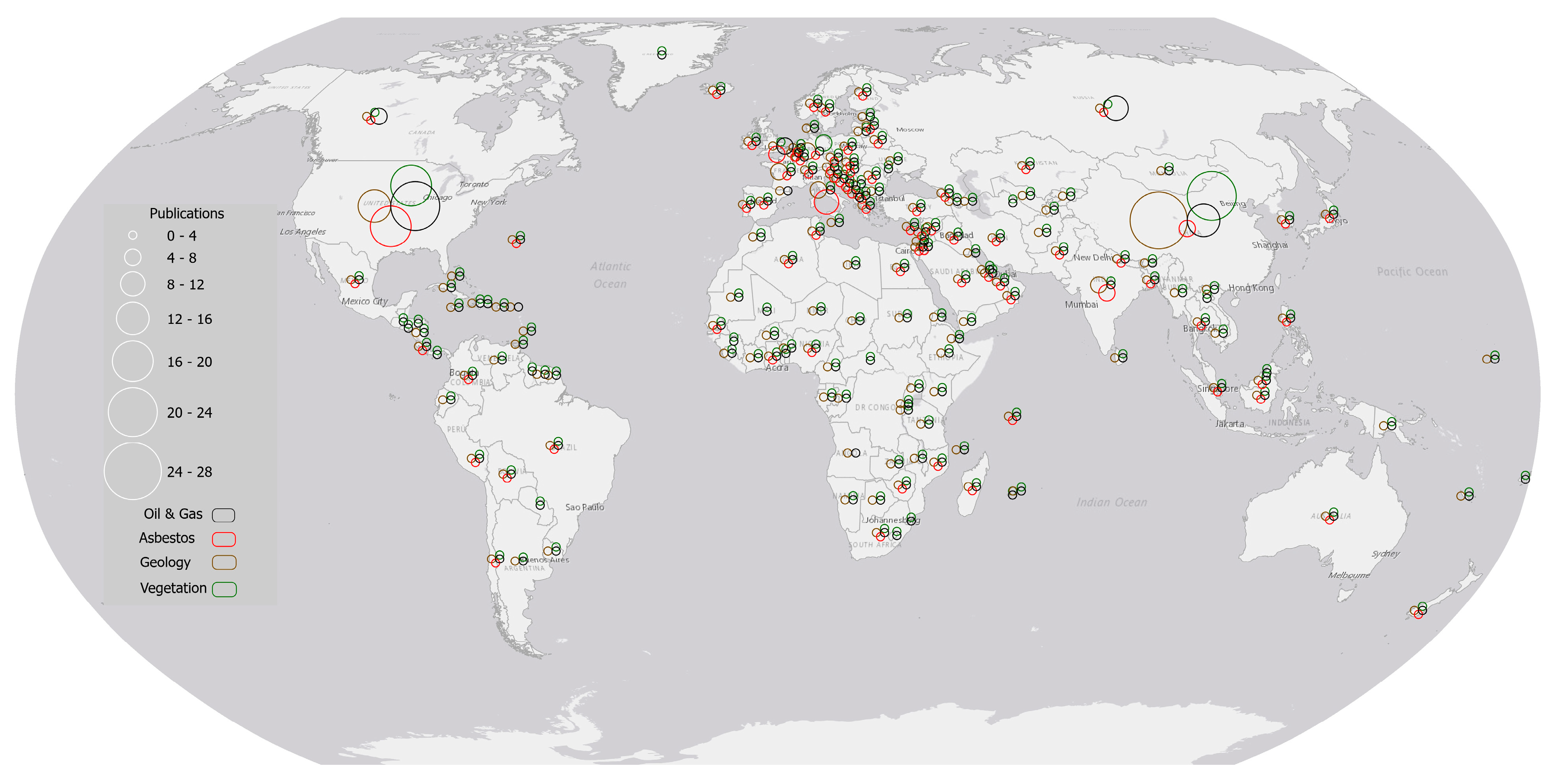
:1. Introduction
2. Methodology
3. Remote Sensing and Asbestos–Cement Roofs
4. Remote Sensing and Vegetation
5. Remote Sensing and Oil and Gas
6. Geology Applications
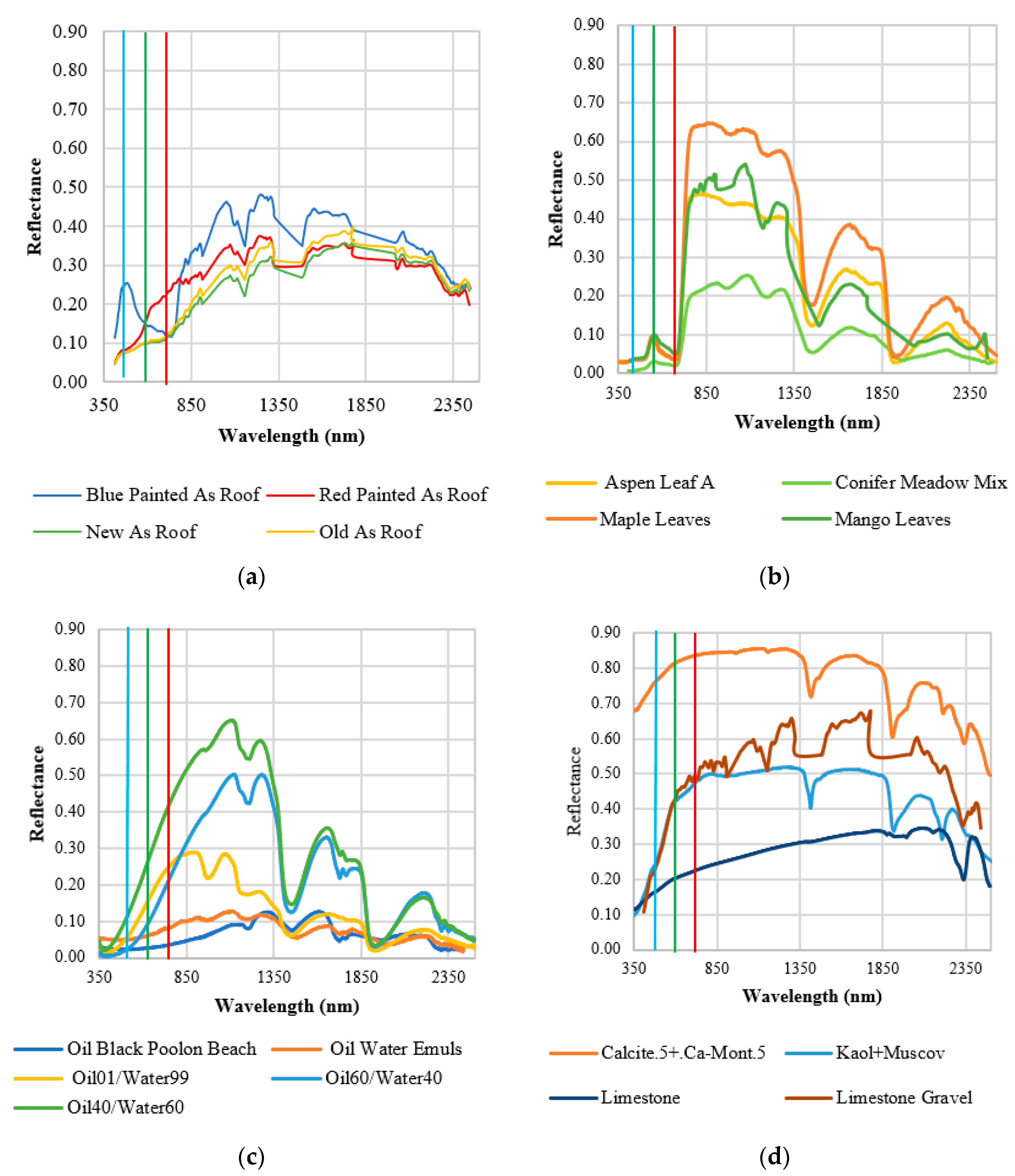
7. Spectral Signature
8. Conclusions
9. Recommendations
Author Contributions
Funding
Institutional Review Board Statement
Informed Consent Statement
Data Availability Statement
Acknowledgments
Conflicts of Interest
Appendix A

| Material | Location | Image Taking Tool | Type of Sensor/Satellite | Number of Bands | Ground Resolution | Methodology | Year | Ref. |
|---|---|---|---|---|---|---|---|---|
| Asbestos | Follonica and Rimini, Italy | Overflight | MIVIS | 102 | 3.0–4.0 m | Spectral Angle Mapper (SAM) | 2008 | [118] |
| Asbestos | Rome, Italia | Overflight | MIVIS | 102 | 4.0 m | Spectral Angle Mapper (SAM) | 2012 | [57] |
| Asbestos | Hyderabad, India | Satellite | QuickBird | 3 | Panchromatic = 0.61–072 m; VNIR = 2.44–2.88 m | PCA-based; line-detection-based | 2012 | [119] |
| Asbestos | Barcelona, Spain | Overflight | Hyperspectral | 32 | 2.0–2.4 m | Integration of rooftop greenhouses | 2017 | [120,121] |
| Asbestos | Lombardía, Italy | Overflight | MIVIS | 102 | 3.0 m | Spectral Angle Mapper (SAM) | 2018 | [54] |
| Asbestos | Debrecen, Hungary | Satellite | WorldView-2 | 8 | Panchromatic = 2 m VNIR= 0.5 m | LDFA = Linear Discriminant Function Analysis; QDFA = Quadratic Discriminant Function Analysis; RF = Random Forest; | 2018 | [56] |
| Asbestos | Prato, Italy | Satellite | WorldView-3 | 16 | Panchromatic = 0.31 m; VNIR = 1.24 m; SWIR= 3.70 m | QGIS Plugin named RoofClassify | 2019 | [30] |
| Asbestos | Chęciny, Poland | Overflight | Orthophotomap | 3 | 0.25 m | Convolutional Neural Networks (CNNs) | 2020 | [44] |
| Asbestos | São José do Rio Preto, Brazil | Satellite | WorldView-3 | 16 | Panchromatic = 0.31 m; VNIR = 1.24 m | Maximum likelihood, mahalanobis distance, and minimum distance. | 2020 | [122] |
| Asbestos | Chęciny and Baranów, Poland | Overflight | Orthophotomap | 3 | 0.25 m | Convolutional Neural Networks (CNNs) | 2022 | [123] |
| Asbestos | Paldal-dong, Daegu, South Korea | Overflight | Orthophotomap | NA | NA | Visual counting method | 2022 | [124] |
| Exploration of oil | Southern Tunisia | Satellite | Landsat Enhanced Thematic Mapper (ETM+); ASTER Red–Green–Blue (RGB) radar (RADARSAT) | See the reference | 10 m to 100 m | Interpretation of the Shuttle Radar Topography Mission (SRTM) Digital Elevation Models (DEMs) | 2006 | [125] |
| Hydrocarbon seepages | Campos Basin, Brazil and Bay of Campeche, SE Gulf of Mexico | Satellite | ASTER | 9 | VNIR= 15 m; SWIR= 30 m; Thermal Infrared (TIR) = 90 m. | Spectral processing of the data; selection and preprocessing (e.g., atmospheric compensation) of ASTER imagery containing seepage records; mapping the extension of oil over water through some classification scheme (e.g., Fuzzy Clustering); selection of representative spectra from seepage pixels extracted from ASTER imagery; integration of multivariate statistics processing. | 2012 | [126] |
| Exploration of oil | Louisiana (USA) (Deep Horizon) and Campo Basin, Brazil | Satellite | EOS AM (Terra) and EOS PM (Aqua) Moderate-Resolution Imaging Spectroradiometer (MODIS) | 36 | 250–1000 m | Object-based image analysis (OBIA) | 2014 | [87] |
| Gas leak | Kelowna, Canada | Unmanned aerial vehicle (UAV) | Laser Methane mini-G SA3C50A | NA | Not specified. Flight altitudes: 25–30 m | Off-the-shelf laser-based methane detector into a multirotor UAV | 2017 | [127] |
| Hydrocarbon seepages | Gulf of Mexico | Satellite | RADARSAT-2; ASTER and WorldView-2 | See the reference | 1–15 m | Oil/emulsion thickness classification using Satellite Synthetic Aperture Radar (SAR) | 2020 | [128] |
| Gas leak | Katowice, Poland | Unmanned aerial vehicle (UAV) | LaserMethane mini SA3C321-BE | NA | Not specified. Flight altitudes: 3.5 m, 6 m, 9 m, 12 m, 15 m, 18 m, 21 m, and 25 m | Data cleaning; background/leakage gas concentration determination; location of the leakage estimation. | 2021 | [129] |
| Hydrocarbon seepages | Sudd Wetlands in South Sudan | Satellite | Sentinel-1; Sentinel-2 | 13 | 10–60 m | Random Forest (RF) | 2021 | [130] |
| Hydrocarbon seepages | Louisiana (USA) (Deep Horizon) | Satellite | Sentinel-1 and RADARSAT-2 | Not specified. | Sentinel-1 = 20m; RADARSAT-2 = 50 m | Faster Region-based Convolutional Neural Network (Faster R-CNN) model | 2022 | [131] |
| Hydrocarbon seepages | Matruh Basin, Egypt | Satellite y Hyperspectral | EO-1 (ALI) and Landsat-7; EO-1 (HYPERION) | 6; 4; 49; 49 | 30 m for all sensors | Spectral Angle Mapper (SAM) | 2022 | [132] |
| Gold exploration | Southeastern Desert of Egypt | Satellite | ASTER and ETM+ | 6 | Not specified | Band ratioing, principal component analysis (PCA), false-color composition (FCC), and frequency filtering (FFT-RWT) | 2012 | [133] |
| General mineral identification | Girón, Colombia | Satellite | Hyperion- Satellite EO-1 | 220 | 30 m | Spectral Angle Mapper (SAM) | 2015 | [134] |
| Geologic mapping | Edembo area, Algerian Sahara | Satellite | Multispectral ASTER | 9 | VNIR = 15 m; SWIR = 30 m; thermal infrared (TIR) = 90 m. | Maximum likelihood classifier method (MLC) | 2016 | [135] |
| Map alteration minerals | Southeast Spain | Satellite | WorldView-3 imagery and ASTER TIR | See the reference | Panchromatic = 0.31 m; VNIR = 1.24 m; SWIR = 3.70 m TIR =90 m. | Spectral Angle Mapper (SAM) | 2019 | [48] |
| Groundwater exploration | Gongola Basin, Nigeria | Satellite | Landsat 8 | 3 | Not specified | Detection of lineaments through geophysical gravity | 2020 | [136] |
| Mineral exploration | Semna region, Eastern Desert (ED) of Egypt | Satellite | Multispectral ASTER | 9 | VNIR = 15 m; SWIR = 30 m; thermal infrared (TIR) = 90 m. | The ASTER data were enhanced in terms of mapping lithological units and the hydrothermal zones | 2010 | [137] |
| Kimberlite exploration | Kimberlite Province, Lesotho | Satellite | ASTER, Shuttle Radar Topography Mission (SRTM) Digital Elevation Model (DEM) and Google Earth | 9 | VNIR = 15 m; SWIR = 30 m | Spectral Angle Mapper (SAM) | 2021 | [138] |
| Iron mineral | Çankırı Province, Turkie | Satellite | Sentinel-2 | 13 | 5, 30 and 60 m | Spectral Angle Mapper (SAM) | 2021 | [139] |
| Structural framework and mineral occurrences | Nimas-Khadra, Southern Arabian | Satellite | ASTER | 14 | VNIR = 15 m SWIR = 30 m TIR = 90 m | Geophysical and image analyses to identify the tectonic framework and establish the relationship of the lithology and tectonic features with the known and prospective mineral occurrences | 2022 | [140] |
| Structural geology measurements of lava flows | Lake Assal, Djibouti | Satellite | Pleiades | 5 | 0.5 m | Mouse Mode (MM) and Virtual Reality (VR) approaches | 2022 | [141] |
| Crustal deformation | Niger Delta Basin | Satellite | Landsat 8, Advanced Land Observation Satellite (ALOS), World 3D DEM | See the reference | 30 m | Integration of satellite images | 2022 | [142] |
| Geological lineaments | Central Turkey | Satellite | Landsat 8; Advanced Land Observing Satellite (ALOS) | 8 | 30 m; 10–100 m | Preprocessing of both optical and radar images, the image enhancement, and the determination of optimal parameter values employed in the extraction of lineaments from the data sets and the verification and the interpretation of the resultant lineament maps | 2022 | [143] |
| Vegetation Indices (VIs) | Formulas | Study Area | Observations | Year | Ref. |
|---|---|---|---|---|---|
| Simple Ratio | SR = NIR/Red | Marysville, USA | A two-wavelength reflectance ratio R745/R675 was developed for an objective index of turf color | 1968 | [144] |
| Normalized Difference Vegetation Index | NDVI = (NIR − Red)/(NIR + Red) | Texas, USA | Multispectral satellite images are used. A method has been developed for quantitative measurement of vegetation conditions over broad regions using ERTS-1 MSS data | 1974 | [145] |
| Green Vegetation Index | GVI = (−0.2848 TM1) + (−0.2435 TM2) + (−0.5436 TM3) + (0.7243 TM4) + (0.0840 TM5) + (−0.18 TM7) | Worldwide | This index minimizes the effects of background soil while emphasizing green vegetation. It uses global coefficients that weigh the pixel values to generate new transformed bands. It is also known as the Landsat TM Tasseled Cap green vegetation index | 1976 | [146] |
| Difference Vegetation Index | DVI = NIR-Red | Maryland, USA | In situ collected spectrometer data were used | 1979 | [147] |
| Soil-Adjusted Vegetation Index | SAVI = (1.5 (NIR − Red))/(NIR + Red + 0.5) | Arizona, USA | Similar to NDVI; nevertheless, it is a proposed index that minimizes soil brightness influences involving red and near-infrared (NIR) spectra | 1988 | [148] |
| Infrared Percentage Vegetation Index | IPVI = NIR/(NIR + Red) | Worldwide | The near-infrared (NIR) versus red “infrared percentage vegetation index,” NIR/(NIR + Red), is functionally and linearly equivalent to the Normalized Difference Vegetation Index, (NIR-Red/(NIR + Red). Advantageously, it is both computationally faster and never negative | 1990 | [149] |
| Global Environmental Monitoring Index | GEMI = η (1 − 0.25 η) + (Red − 0.125)/(1 − Red) η = 2(NIR2 − Red2) + 1.5NIR + 0.5Red)/(NIR + Red + 0.5) | Worldwide | Designed specifically to reduce the relative effects of these undesirable atmospheric perturbations | 1992 | [150] |
| Atmospherically Resistant Vegetation Index Difference Vegetation | ARVI = (NIR − (Red − γ(Blue − Red)))/(NIR + (Red − γ(Blue − Red))) | Worldwide | MODIS sensor. ARVI has a similar dynamic range to the NDVI but is on average four times less sensitive to atmospheric effects than the NDVI | 1992 | [151] |
| Modified Soil-Adjusted Vegetation Index 2 | MSAVI2 = (2 NIR + 1-√((2 IR + 1)-8 (NIR-Red)))/2 | Tucson, USA | This index is a simpler version of the MSAVI proposed by Qi et al. (1994), which improves upon the Soil-Adjusted Vegetation Index (SAVI). It reduces soil noise and increases the dynamic range of the vegetation signal. MSAVI2 is based on an inductive method that does not use a constant L value (as with SAVI) to highlight healthy vegetation [152] | 1994 | [153] |
| Nonlinear Index | NLI = (NIR2 − Red)/(NIR2 + Red) | Detroit, USA | Multispectral satellite images are used. A comparison between 3D crop model and several VIs is proposed focusing on soil brightness, optical properties of canopy elements, leaf angle distribution, and spacing, among others. The authors found that VIs using off-nadir reflectances are more informative and useful than those based on nadir reflectances; the optimal VI and sun/view geometries are usually different for inferring different parameters, depending on canopy architecture; and LAI can be practically estimated by VI only for homogeneous canopies | 1994 | [154] |
| Renormalized Difference Vegetation Index | RDVI = (NIR − Red)/√(NIR + Red) | Toulouse, France | Similar to NDVI; nevertheless, a VI to minimize soil effects is proposed | 1995 | [155] |
| Structurally Independent Pigment | SIPI = (NIR–Blue)/(NIR–Red) | Barcelona, Spain | The index minimizes the confounding effect of leaf surface and mesophyll structure | 1995 | [156] |
| Optimized Soil-Adjusted Vegetation Index | OSAVI = (NIR − Red)/(NIR + Red + 0.16) | Nottingham, UK | Similar to NDVI; nevertheless, the value of the parameter X is critical in the minimization of soil effects. A value of 0.16 is proposed | 1996 | [157] |
| Green Atmospherically Resistant Index | GARI = (NIR – [Green-γ(Blue – Red)])/(NIR + [Green-γ(Blue – Red)]) | Worldwide | MODIS sensor. GARI is tailored to the concept of ARVI. Resistant to atmospheric effects as ARVI but more sensitive to a wide range of Chl-a concentrations. While NDVI and ARVI are sensitive to vegetation fraction and to rate of absorption of photosynthetic solar radiation, a green vegetation index such as GARI should be added to sense the concentration of chlorophyll, to measure the rate of photosynthesis, and to monitor plant stress. | 1996 | [158] |
| Modified Simple Ratio | MSR = ((NIR/Red) − 1)/(√(NIR/Red) + 1) | Ottawa, Canada | Multispectral satellite images are used to classify boreal forests. They evaluate several vegetation indices against experimental data sets for their performance in terms of the ability to minimize the error induced by noise in remote sensing data. The authors propose a nonlinear index that has the advantage of both low noise effects and good linearity with biophysical parameters | 1996 | [159] |
| Green Normalized Difference Vegetation Index | GNDVI = (NIR − Green)/NIR + Green) | Worldwide | Satellite images for remote sensing of chlorophyll concentration | 1998 | [160] |
| Green Leaf Index (GLI) | GLI = ((Green – Red) + (Green – Blue))/(2*Green + Red + Blue) | Oregon, USA | This index was originally designed for use with a digital RGB camera to measure wheat cover, where the red, green, and blue digital numbers (DNs) range from 0 to 255 GLI values range from −1 to +1. Negative values represent soil and nonliving features, while positive values represent green leaves and stems [152]. | 2001 | [161] |
| Enhanced Vegetation Index | EVI = 2.5 (NIR-Red)/(NIR + (6 Red) − (7.5 Blue) + 1) | Worldwide | The study was performed using the Moderate Resolution Imaging Spectroradiometer (MODIS), which is a 36-band imaging radiometer, on the NASA Earth Observing System (EOS) satellites Terra [162] | 2002 | [163] |
| Leaf Area Index | LAI = 3.618 × EVI – 0.118 | Denmark | Multispectral data were acquired with the Compact Airborne Spectral Imager (CASI). The results allowed for the evaluation of the spatial variations in the photosynthetic light, nitrogen, and water use efficiencies. While photosynthesis was linearly related to transpiration, the light use efficiency (LUE) was found to be dependent on nitrogen concentrations | 2002 | [164] |
| Visible Atmospherically Resistant Index | VARI = (Green − Red)/(Green + Red − Blue) | Nebraska, USA | The goal of this study was to investigate the information content of reflectance spectra of crops in the visible and near-infrared range of the spectrum and develop a technique for remote estimation of vegetation fraction | 2002 | [165] |
| Transformed Difference Vegetation Index | TDVI = 1.5((NIR-Red)/√(NIR2 + Red + 0.5)) | Ottawa, Canada | This index shows the same sensitivity as the Soil-Adjusted Vegetation Index (SAVI) to the optical properties of bare soil subjacent to the cover. It does not saturate like NDVI and SAVI and it shows an excellent linearity as a function of the rate of vegetation cover | 2002 | [166] |
| Green Chlorophyll Index | GCI = (NIR + Green) − 1 | Lincoln, USA | This index is used to estimate leaf chlorophyll content across a wide range of plant species. Having broad NIR and green wavelengths provides a better prediction of chlorophyll content while allowing for more sensitivity and a higher signal-to-noise ratio [152] | 2003 | [167] |
| Sum Green Index | SGI = Green | California, USA | SGI is the mean of reflectance across the 500 nm to 600 nm portion of the spectrum. The sum is then normalized by the number of bands to convert it back to units of reflectance. The value of this index ranges from 0 to more than 50 (in units of % reflectance). The common range for green vegetation is 10 to 25 percent reflectance [152]. | 2003 | [168] |
| Wide Dynamic Range Vegetation Index | WDRVI = (a NIR-Red)/(a NIR + Red) | Lincoln, NE, USA | This index is similar to NDVI, but it uses a weighting coefficient (a) to reduce the disparity between the contributions of the near-infrared and red signals to the NDVI. The WDRVI is particularly effective in scenes that have moderate-to-high vegetation density when NDVI exceeds 0.6. NDVI tends to level off when vegetation fraction and leaf area index (LAI) increase, whereas the WDRVI is more sensitive to a wider range of vegetation fractions and to changes in LAI. The weighting coefficient (a) can range from 0.1 to 0.2. ENVI uses a value of 0.2, as recommended by Henebry, Viña, and Gitelson (2004) [152] | 2004 | [169] |
| Green Optimized Soil-Adjusted Vegetation Index | GOSAVI = (NIR-Green)/(NIR + Green + 0.16) | North Carolina, USA | This index was originally designed with color–infrared photography to predict nitrogen requirements for corn. It is similar to OSAVI, but it substitutes the green band for red [152] | 2005 | [170] |
| Green Difference | GDVI = NIR - Green | North Carolina Coastal Plain, USA | Aerial photography used for nitrogen requirements in corn | 2006 | [171] |
| Green Ratio Vegetation Index | GRVI = NIR/Green | North Carolina Coastal Plain, USA | Aerial photography used for nitrogen requirements in corn | 2006 | [171] |
| Modified Nonlinear Index | MNLI = ((NIR2 − Red) × (1 + L))/(NIR2 + Red + L) | Colorado, USA | Multispectral satellite images. The impact of using band ratio and vegetation indices of the AWIFS sensor images to the crop classification accuracy is empirically investigated via supervised classification. The research indicates that appropriately used vegetation indices and image ratios can potentially improve crop classification accuracy | 2008 | [172] |
| MERIS terrestrial chlorophyll index | MTCI = (R740 − R705)/(R705 − R665) | Southampton, UK | This paper reports on the design and indirect evaluation of a surrogate REP index for use with spectral data recorded at the standard band settings of the Medium Resolution Imaging Spectrometer (MERIS). This index, termed the MERIS terrestrial chlorophyll index (MTCI), was evaluated using model spectra, field spectra, and MERIS data | 2010 | [173] |
| Normalized Area Over Reflectance Curve | Where ρ is the reflectance; λ is the wavelength; ρmax is the maximum far-red reflectance, corresponding to reflectance at the wavelength “b”; and “a” and “b” are the integration limits surrounding the chlorophyll well centered at ∼670 nm. | Valencia, Spain | The Normalized Area Over Reflectance Curve (NAOC) is proposed as a new index for remote sensing estimation of the leaf chlorophyll content of heterogeneous areas with different crops, different canopies, and different types of bare soil. This index is based on the calculation of the area over the reflectance curve obtained by high spectral resolution reflectance measurements determined from the integral of the red–near-infrared interval and divided by the maximum reflectance in that spectral region | 2010 | [75] |
| Triangular Greenness Index | TGI = ((λRed − λBlue)(ρRed − ρGreen) − (λRed − λGreen)(ρRed − ρBlue))/2 | Maryland, USA | This index approximates the area of a triangle bounding a leaf reflectance spectrum, where the vertices are in the red, green, and blue wavelengths. The Lambda (λ) terms represent the center wavelengths of the respective bands. The Rho (ρ) terms represent the pixel values of those bands. The original TGI equation (Hunt et al., 2011) used 670 nm, 550 nm, and 480 nm for the red, green, and blue wavelength centers, with a 10 nm band width [152] | 2011 | [174] |
| WorldView Improved Vegetative Index | WV-VI = (NIR2-Red)/(NIR2 + Red) | Maryland, USA | This index uses WorldView-2 bands to compute NDVI. The value of this index ranges from −1 to 1. The common range for green vegetation is 0.2 to 0.8 [152] | 2012 | [175] |
| Enhanced Normalized Difference Vegetation Index | ENDVI = ((NIR + Green) − (2 × Blue))/((NIR + Green) + (2 × Blue)) | Carlstadt, USA | The blue channel for NDVI can be used equally as well for the visible absorption channel as the Kodak film using red as the visible absorption channel Maxar found that better results are achieved using red and green as the reflective channels while using blue as the absorption channel | 2015 | [176,177,178,179] |
References
- Furukawa, K. Resource Base: Global Distribution and Characteristics of Estuaries and Associated Coastal Shores. Treatise Estuar. Coast. Sci. 2012, 1, 207–228. [Google Scholar] [CrossRef]
- Earthdata What Is Remote Sensing? 2022. Available online: https://www.earthdata.nasa.gov/learn/backgrounders/remote-sensing (accessed on 23 September 2022).
- Horning, N. Remote Sensing. Encycl. Ecol. 2019, 7, 404–413. [Google Scholar] [CrossRef]
- Xiong, X.; Butler, J. Volume 1 Overview. Compr. Remote Sens. 2018, 1, 1–6. [Google Scholar] [CrossRef]
- Calvet, J.-C.; Albergel, C.; Baghdadi, N.; Leroux, D.; Munier, S. Chapter 6—Remote sensing. Water Resour. Mediterr. Reg. 2020, 1, 137–156. [Google Scholar] [CrossRef]
- Haus, H.A.; Melcher, J.R. Electromagnetic Fields and Energy; Prentice Hall: Cambridge, MA, USA, 1989. [Google Scholar]
- Lorrain, P. Fundamentals of Electromagnetic Phenomena; W.H. Freeman: New York, NY, USA, 2000. [Google Scholar]
- Adler, R.B.; Chu, L.J.; Fano, R.M. Electromagnetic Energy Transmission and Radiation; The MIT Press: Cambridge, MA, USA, 1968. [Google Scholar]
- Ting, D. Thermal radiation. Thermofluids 2022, 357–372. [Google Scholar] [CrossRef]
- Rani, M.; Masroor, M.; Kumar, P. Remote sensing of Ocean and Coastal Environment—Overview. Remote Sens. Ocean Coast. Environ. 2021, 1, 1–15. [Google Scholar] [CrossRef]
- Krug, L.A.; Platt, T.; Sathyendranath, S.; Barbosa, A.B. Ocean surface partitioning strategies using ocean colour remote Sensing: A review. Prog. Oceanogr. 2017, 155, 41–53. [Google Scholar] [CrossRef]
- Gale, M.G.; Cary, G.J.; Van Dijk, A.I.J.M.; Yebra, M. Forest fire fuel through the lens of remote sensing: Review of approaches, challenges and future directions in the remote sensing of biotic determinants of fire behaviour. Remote Sens. Environ. 2021, 255, 112282. [Google Scholar] [CrossRef]
- Yu, Y.; Fu, L.; Cheng, Y.; Ye, Q. Multi-view distance metric learning via independent and shared feature subspace with applications to face and forest fire recognition, and remote sensing classification. Knowledge-Based Syst. 2022, 243, 108350. [Google Scholar] [CrossRef]
- de Jesus, C.S.L.; Delgado, R.C.; Wanderley, H.S.; Teodoro, P.E.; Pereira, M.G.; Lima, M.; de Ávila Rodrigues, R.; da Silva Junior, C.A. Fire risk associated with landscape changes, climatic events and remote sensing in the Atlantic Forest using ARIMA model. Remote Sens. Appl. Soc. Environ. 2022, 26, 100761. [Google Scholar] [CrossRef]
- Wetherley, E.B.; Roberts, D.A.; Tague, C.L.; Jones, C.; Quattrochi, D.A.; McFadden, J.P. Remote sensing and energy balance modeling of urban climate variability across a semi-arid megacity. Urban Clim. 2021, 35, 100757. [Google Scholar] [CrossRef]
- Avand, M.; Moradi, H.; lasboyee, M.R. Using machine learning models, remote sensing, and GIS to investigate the effects of changing climates and land uses on flood probability. J. Hydrol. 2021, 595, 125663. [Google Scholar] [CrossRef]
- Ganci, G.; Cappello, A.; Bilotta, G.; Del Negro, C. How the variety of satellite remote sensing data over volcanoes can assist hazard monitoring efforts: The 2011 eruption of Nabro volcano. Remote Sens. Environ. 2020, 236, 111426. [Google Scholar] [CrossRef]
- McAlpin, D.; Meyer, F.J. Multi-sensor data fusion for remote sensing of post-eruptive deformation and depositional features at Redoubt Volcano. J. Volcanol. Geotherm. Res. 2013, 259, 414–423. [Google Scholar] [CrossRef]
- Fu, X.; Yao, L.; Xu, W.; Wang, Y.; Sun, S. Exploring the multitemporal surface urban heat island effect and its driving relation in the Beijing-Tianjin-Hebei urban agglomeration. Appl. Geogr. 2022, 144, 102714. [Google Scholar] [CrossRef]
- Bovolo, F.; Bruzzone, L.; Solano-Correa, Y.T. Multitemporal Analysis of Remotely Sensed Image Data. Compr. Remote Sens. 2018, 2, 156–185. [Google Scholar] [CrossRef]
- Wu, X.; Xiao, Q.; Wen, J.; You, D.; Hueni, A. Advances in quantitative remote sensing product validation: Overview and current status. Earth-Sci. Rev. 2019, 196, 102875. [Google Scholar] [CrossRef]
- Rivera-Marin, D.; Dash, J.; Ogutu, B. The use of remote sensing for desertification studies: A review. J. Arid Environ. 2022, 206, 104829. [Google Scholar] [CrossRef]
- Veettil, B.K.; Hong Quan, N.; Hauser, L.T.; Doan Van, D.; Quang, N.X. Coastal and marine plastic litter monitoring using remote sensing: A review. Estuar. Coast. Shelf Sci. 2022, 279, 108160. [Google Scholar] [CrossRef]
- Wang, P.; Bayram, B.; Sertel, E. A comprehensive review on deep learning based remote sensing image super-resolution methods. Earth-Sci. Rev. 2022, 232, 104110. [Google Scholar] [CrossRef]
- Ali, A.M.; Abouelghar, M.; Belal, A.A.; Saleh, N.; Yones, M.; Selim, A.I.; Amin, M.E.S.; Elwesemy, A.; Kucher, D.E.; Maginan, S.; et al. Crop Yield Prediction Using Multi Sensors Remote Sensing (Review Article). Egypt. J. Remote Sens. Space Sci. 2022, 25, 711–716. [Google Scholar] [CrossRef]
- Liu, C.; Xing, C.; Hu, Q.; Wang, S.; Zhao, S.; Gao, M. Stereoscopic hyperspectral remote sensing of the atmospheric environment: Innovation and prospects. Earth-Sci. Rev. 2022, 226, 103958. [Google Scholar] [CrossRef]
- Chen, Z.; Deng, L.; Luo, Y.; Li, D.; Marcato Junior, J.; Nunes Gonçalves, W.; Awal Md Nurunnabi, A.; Li, J.; Wang, C.; Li, D. Road extraction in remote sensing data: A survey. Int. J. Appl. Earth Obs. Geoinf. 2022, 112, 102833. [Google Scholar] [CrossRef]
- Shirmard, H.; Farahbakhsh, E.; Müller, R.D.; Chandra, R. A review of machine learning in processing remote sensing data for mineral exploration. Remote Sens. Environ. 2022, 268, 112750. [Google Scholar] [CrossRef]
- Asadzadeh, S.; de Oliveira, W.J.; de Souza Filho, C.R. UAV-based remote sensing for the petroleum industry and environmental monitoring: State-of-the-art and perspectives. J. Pet. Sci. Eng. 2022, 208, 109633. [Google Scholar] [CrossRef]
- Tommasini, M.; Bacciottini, A.; Gherardelli, M. A QGIS Tool for Automatically Identifying Asbestos Roofing. ISPRS Int. J. Geo-Inf. 2019, 8, 131. [Google Scholar] [CrossRef] [Green Version]
- Stevulova, N.; Estokova, A.; Holub, M.; Singovszka, E. Demolition waste contaminated with asbestos. Adv. Toxic. Constr. Build. Mater. 2022, 1, 261–283. [Google Scholar] [CrossRef]
- Obmiński, A. Asbestos cement products and their impact on soil contamination in relation to various sources of anthropogenic and natural asbestos pollution. Sci. Total Environ. 2022, 848, 157275. [Google Scholar] [CrossRef]
- OMS. Eliminación de las Enfermedades Relacionadas con el Asbestos. 2020. Available online: https://www.who.int/es/news-room/fact-sheets/detail/asbestos-elimination-of-asbestos-related-diseases (accessed on 2 December 2022).
- Frank, A.L.; Joshi, T.K. The global spread of asbestos. Ann. Glob. Heal. 2014, 80, 257–262. [Google Scholar] [CrossRef]
- Villamizar, G.; Camero, G. Asbesto en Colombia. Fundamentos Para el Debate; Universidad Nacional de Colombia: Bogotá, Colombia, 2019. [Google Scholar]
- Książek, J. Methods for Detection of Asbestos-Cement Roof ng Sheets. Geomatics Environ. Eng. 2014, 8, 59–76. [Google Scholar] [CrossRef]
- Hemminki, K.; Försti, A.; Chen, T.; Hemminki, A. Incidence, mortality and survival in malignant pleural mesothelioma before and after asbestos in Denmark, Finland, Norway and Sweden. BMC Cancer 2021, 21, 1189. [Google Scholar] [CrossRef] [PubMed]
- Statista. Major Countries in Worldwide Asbestos Mine Production in 2021. 2021. Available online: https://www.statista.com/statistics/264923/world-mine-production-of-asbestos/ (accessed on 7 October 2022).
- Carmonaa, R.E.; Rivera Rosalesa, R.M. Asbestosis y mesotelioma pleural maligno. Rev. Fac. Med. 2013, 52, 5–17. [Google Scholar]
- Selikoff, I.J.; Lee, D.H.K. Asbestos and disease. Asbestos Dis. 1979, 36, 157–158. [Google Scholar] [CrossRef] [Green Version]
- Navarro-Vargas, J.R.; Villamizar, G.A. Artículo de Reflexión El largo y sinuoso camino de la enfermedad laboral en Colombia. El caso de la asbestosis. Rev. De La Acad. Nac. De Med. 2019, 231–240. [Google Scholar]
- Neitzel, R.L.; Sayler, S.K.; Demond, A.H.; d’Arcy, H.; Garabrant, D.H.; Franzblau, A. Measurement of asbestos emissions associated with demolition of abandoned residential dwellings. Sci. Total Environ. 2020, 722, 137891. [Google Scholar] [CrossRef] [PubMed]
- Frassy, F.; Candiani, G.; Rusmini, M.; Maianti, P.; Marchesi, A.; Nodari, F.R.; Via, G.D.; Albonico, C.; Gianinetto, M. Mapping asbestos-cement roofing with hyperspectral remote sensing over a large mountain region of the Italian western alps. Sensors 2014, 14, 15900–15913. [Google Scholar] [CrossRef] [PubMed] [Green Version]
- Krówczyńska, M.; Raczko, E.; Staniszewska, N.; Wilk, E. Asbestos-cement roofing identification using remote sensing and convolutional neural networks (CNNs). Remote Sens. 2020, 12, 408. [Google Scholar] [CrossRef] [Green Version]
- Suomalainen, J.; Oliveira, R.A.; Hakala, T.; Koivumäki, N.; Markelin, L.; Näsi, R.; Honkavaara, E. Direct reflectance transformation methodology for drone-based hyperspectral imaging. Remote Sens. Environ. 2021, 266, 112691. [Google Scholar] [CrossRef]
- Pfitzner, K.; Bartolo, R.; Whiteside, T.; Loewensteiner, D.; Esparon, A. Multi-temporal spectral reflectance of tropical savanna understorey species and implications for hyperspectral remote sensing. Int. J. Appl. Earth Obs. Geoinf. 2022, 112, 102870. [Google Scholar] [CrossRef]
- Scopus. Scopus Research. 2020. Available online: https://unicartagena.elogim.com:2085/results/results.uri?sort=plf-f&src=s&st1=Asbestos+&nlo=&nlr=&nls=&sid=ab9cb7ceaa0a84c920417ae66c0e2036&sot=b&sdt=cl&cluster=scoaffilctry%2C%22Colombia%22%2Ct&sl=24&s=TITLE-ABS-KEY%28Asbestos+%29&cl=t&offset=21&origin=r (accessed on 7 October 2020).
- Bedini, E. Application of WorldView-3 imagery and ASTER TIR data to map alteration minerals associated with the Rodalquilar gold deposits, southeast Spain. Adv. Space Res. 2019, 63, 3346–3357. [Google Scholar] [CrossRef]
- Carlos Chicaíza-Rojas, L.; Francisco Lopez-Parra, J. Uso de imágenes satelitales para detección y cuantificación de asbesto. DYNA 2014, 81, 1–2. [Google Scholar]
- The European Space Agency. WorldView-3 Instruments. 2022. Available online: https://earth.esa.int/eogateway/missions/worldview-3 (accessed on 13 December 2022).
- Szabó, S.; Burai, P.; Kovács, Z.; Szabó, G.; Kerényi, A.; Fazekas, I.; Paládi, M.; Buday, T.; Szabó, G. Testing algorithms for the identification of asbestos roofing based on hyperspectral data. Environ. Eng. Manag. J. 2014, 143, 512900. [Google Scholar] [CrossRef]
- Cilia, C.; Panigada, C.; Rossini, M.; Candiani, G.; Pepe, M.; Colombo, R. Mapping of Asbestos Cement Roofs and Their Weathering Status Using Hyperspectral Aerial Images. ISPRS Int. J. Geo-Inf. 2015, 4, 928–941. [Google Scholar] [CrossRef]
- Gibril, M.B.A.; Shafri, H.Z.M.; Hamedianfar, A. New semi-automated mapping of asbestos cement roofs using rule-based object-based image analysis and Taguchi optimization technique from WorldView-2 images. Int. J. Remote Sens. 2017, 38, 467–491. [Google Scholar] [CrossRef]
- Bassani, C.; Cavalli, R.M.; Cavalcante, F.; Cuomo, V.; Palombo, A.; Pascucci, S.; Pignatti, S. Deterioration status of asbestos-cement roofing sheets assessed by analyzing hyperspectral data. Remote Sens. Environ. 2007, 109, 361–378. [Google Scholar] [CrossRef]
- Norman, M.; Mohd Shafri, H.Z.; Idrees, M.O.; Mansor, S.; Yusuf, B. Spatio-statistical optimization of image segmentation process for building footprint extraction using very high-resolution WorldView 3 satellite data. Geocarto Int. 2019, 35, 1124–1147. [Google Scholar] [CrossRef]
- Abriha, D.; Kovács, Z.; Ninsawat, S.; Bertalan, L.; Balázs, B.; Szabó, S. Identification of roofing materials with Discriminant Function Analysis and Random Forest classifiers on pan-sharpened WorldView-2 imagery—A comparison. Hungarian Geogr. Bull. 2018, 67, 375–392. [Google Scholar] [CrossRef] [Green Version]
- Fiumi, L.; Campopiano, A.; Casciardi, S.; Ramires, D. Method validation for the identification of asbestos–cement roofing. Appl. Geomatics 2012, 4, 55–64. [Google Scholar] [CrossRef]
- Wu, P.-Y.; Sandels, C.; Mjörnell, K.; Mangold, M.; Johansson, T. Predicting the presence of hazardous materials in buildings using machine learning. Build. Environ. 2022, 213, 108894. [Google Scholar] [CrossRef]
- Ashtari, A.; Alizadeh, B. A comparative study of machine learning classifiers for secure RF-PUF-based authentication in internet of things. Microprocess. Microsyst. 2022, 93, 104600. [Google Scholar] [CrossRef]
- LeCun, Y.; Boser, B.; Denker, J.S.; Henderson, D.; Howard, R.E.; Hubbard, W.; Jackel, L.D. Backpropagation Applied to Handwritten Zip Code Recognition. Neural Comput. 1989, 1, 541–551. [Google Scholar] [CrossRef]
- Krizhevsky, B.A.; Sutskever, I.; Hinton, G.E. ImageNet Classification with Deep Convolutional Neural Networks. Commun. ACM 2012, 60, 84–90. [Google Scholar] [CrossRef] [Green Version]
- Kazan-Allen, L. Asbestos Profile: European Union; International Asbestos Ban Secretariat: Bruxelles, Belgium, 2019; Available online: http://www.ibasecretariat.org/prof_eu.php (accessed on 23 September 2022).
- Norman, M.; Shafri, H.Z.M.; Mansor, S.; Yusuf, B.; Radzali, N.A.W.M. Fusion of multispectral imagery and LiDAR data for roofing materials and roofing surface conditions assessment. Int. J. Remote Sens. 2020, 41, 1–22. [Google Scholar] [CrossRef]
- García-Pardo, K.A.; Moreno-Rangel, D.; Domínguez-Amarillo, S.; García-Chávez, J.R. Remote sensing for the assessment of ecosystem services provided by urban vegetation: A review of the methods applied. Urban For. Urban Green. 2022, 74, 127636. [Google Scholar] [CrossRef]
- Neinavaz, E.; Schlerf, M.; Darvishzadeh, R.; Gerhards, M.; Skidmore, A.K. Thermal infrared remote sensing of vegetation: Current status and perspectives. Int. J. Appl. Earth Obs. Geoinf. 2021, 102, 102415. [Google Scholar] [CrossRef]
- Pérez-Cabello, F.; Montorio, R.; Alves, D.B. Remote sensing techniques to assess post-fire vegetation recovery. Curr. Opin. Environ. Sci. Heal. 2021, 21, 100251. [Google Scholar] [CrossRef]
- Andreatta, D.; Gianelle, D.; Scotton, M.; Dalponte, M. Estimating grassland vegetation cover with remote sensing: A comparison between Landsat-8, Sentinel-2 and PlanetScope imagery. Ecol. Indic. 2022, 141, 109102. [Google Scholar] [CrossRef]
- Meusburger, K.; Bänninger, D.; Alewell, C. Estimating vegetation parameter for soil erosion assessment in an alpine catchment by means of QuickBird imagery. Int. J. Appl. Earth Obs. Geoinf. 2010, 12, 201–207. [Google Scholar] [CrossRef]
- Henrich, V.; Krauss, G.; Götze, C.; Sandow, C. Index DataBase. A Database for Remote Sensing Indices. 2012. Available online: https://www.indexdatabase.de/db/i.php (accessed on 29 September 2022).
- Huang, S.; Tang, L.; Hupy, J.P.; Wang, Y.; Shao, G. A commentary review on the use of normalized difference vegetation index (NDVI) in the era of popular remote sensing. J. For. Res. 2021, 32, 1–6. [Google Scholar] [CrossRef]
- Beltrán Hernández, D.H. Aplicación de Indices de Vegetación Para Evaluar Procesos de Restauración Ecológica en el Parque Forestal Embalse del Neusa; Universidad Militar Nueva Granada: Neusa, Colombia, 2017. [Google Scholar]
- Song, Y.; Chen, B.; Ho, H.C.; Kwan, M.-P.; Liu, D.; Wang, F.; Wang, J.; Cai, J.; Li, X.; Xu, Y.; et al. Observed inequality in urban greenspace exposure in China. Environ. Int. 2021, 156, 106778. [Google Scholar] [CrossRef]
- Sánchez-Méndez, A.G.; Arguijo-Hernández, S.P. Análisis de imágenes multiespectrales para la detección de cultivos y detección de plagas y enfermedades en la producción de café. Res. Comput. Sci. 2018, 147, 309–317. [Google Scholar] [CrossRef]
- Pedrali, L.D.; Borges Júnior, N.; Pereira, R.S.; Tramontina, J.; Alba, E.; Marchesan, J. Multispectral remote sensing for determining dry severity levels of pointers in Eucalyptus spp. Sci. For. 2019, 122, 224–234. [Google Scholar]
- Vales, J.J.; Pino, I.; Granado, L.; Prieto, R.; Méndez, E.; Rodríguez, M.; Giménez de Azcárate, F.; Ortega, E.; Moreira, J.M. Cartografía de la afección y recuperación vegetal del incendio de Las Peñuelas en Moguer (Huelva) con imágenes satelitales. Rev. Teledetección 2020, 57, 79. [Google Scholar] [CrossRef]
- Michalijos, M.P.; Uboldi, J. Propuesta metodológica para la evaluación de áreas afectadas por incendios mediante el uso de imágenes satelitales (Sierra de la Ventana, Argentina). Rev. Geogr. Norte Gd. 2013, 56, 223–234. [Google Scholar] [CrossRef]
- Delegido, J.; Alonso, L.; González, G.; Moreno, J. Estimating chlorophyll content of crops from hyperspectral data using a normalized area over reflectance curve (NAOC). Int. J. Appl. Earth Obs. Geoinf. 2010, 12, 165–174. [Google Scholar] [CrossRef]
- Saito, H.; Uchiyama, S.; Teshirogi, K. Rapid vegetation recovery at landslide scars detected by multitemporal high-resolution satellite imagery at Aso volcano, Japan. Geomorphology 2022, 398, 107989. [Google Scholar] [CrossRef]
- Dennison, P.E.; Roberts, D.A. The effects of vegetation phenology on endmember selection and species mapping in southern California chaparral. Remote Sens. Environ. 2003, 87, 295–309. [Google Scholar] [CrossRef]
- Dennison, P.E.; Roberts, D.A. Endmember selection for multiple endmember spectral mixture analysis using endmember average RMSE. Remote Sens. Environ. 2003, 87, 123–135. [Google Scholar] [CrossRef]
- Kokaly, R.F.; Despain, D.G.; Clark, R.N.; Livo, K.E. Mapping vegetation in Yellowstone National Park using spectral feature analysis of AVIRIS data. Remote Sens. Environ. 2003, 84, 437–456. [Google Scholar] [CrossRef] [Green Version]
- Frassy, F.; Maianti, P.; Marchesi, A.; Nodari, F.R.; Dalla Via, G.; De Paulis, R.; Biffi, P.G.; Gianinetto, M. Satellite remote sensing for hydrocarbon exploration in new venture areas. In Proceedings of the 2015 IEEE International Geoscience and Remote Sensing Symposium (IGARSS), Milan, Italy, 26–31 July 2015; pp. 2884–2887. [Google Scholar] [CrossRef]
- Fingas, M.; Wang, Z.; Fieldhouse, B.; Smith, P. Environment Canada Arctic and Marine Oil Spill Program Technical Seminar (AMOP) Proceedings. 2003. Available online: https://www.researchgate.net/publication/256925779_The_correlation_of_chemical_characteristics_of_an_oil_to_dispersant_effectiveness (accessed on 2 December 2022).
- Salisbury, J.W.; D’Aria, D.M.; Sabins, F.F. Thermal infrared remote sensing of crude oil slicks. Remote Sens. Environ. 1993, 45, 225–231. [Google Scholar] [CrossRef]
- Sabins, F.F. Remote sensing for petroleum exploration, Part 1: Overview of imaging systems. Lead. Edge 2012, 17, 467. [Google Scholar] [CrossRef]
- Desmond, D.S.; Crabeck, O.; Lemes, M.; Harasyn, M.L.; Mansoori, A.; Saltymakova, D.; Fuller, M.C.; Rysgaard, S.; Barber, D.G.; Isleifson, D.; et al. Investigation into the geometry and distribution of oil inclusions in sea ice using non-destructive X-ray microtomography and its implications for remote sensing and mitigation potential. Mar. Pollut. Bull. 2021, 173, 112996. [Google Scholar] [CrossRef] [PubMed]
- Aweda, E.D.; Adeyewa, Z.D. Inter annual variation of vegetation anomaly over Nigeria using satellite-derived index. Adv. Appl. Sci. Res. 2011, 2, 468–475. [Google Scholar]
- Obida, C.B.; Blackburn, G.A.; Whyatt, J.D.; Semple, K.T. Counting the cost of the Niger Delta’s largest oil spills: Satellite remote sensing reveals extensive environmental damage with >1million people in the impact zone. Sci. Total Environ. 2021, 775, 145854. [Google Scholar] [CrossRef]
- Maianti, P.; Rusmini, M.; Tortini, R.; Dalla Via, G.; Frassy, F.; Marchesi, A.; Rota Nodari, F.; Gianinetto, M. Monitoring large oil slick dynamics with moderate resolution multispectral satellite data. Nat. Hazards 2014, 73, 473–492. [Google Scholar] [CrossRef]
- Gianinetto, M.; Frassy, F.; Marchesi, A.; Maianti, P.; De Paulis, R.; Biffi, P.G.; Nodari, F.R. Mapping large-scale microseepage signals for supporting oil and gas exploration in new ventures. Int. Geosci. Remote Sens. Symp. 2016, 2016, 5430–5433. [Google Scholar] [CrossRef]
- Bhadra, B.K.; Pathak, S.; Nanda, D.; Gupta, A.; Rao, S.S. Spectral characteristics of talc and mineral abundance mapping in the Jahazpur Belt of Rajasthan, India using AVIRIS-NG data. Int. J. Remote Sens. 2020, 41, 8757–8777. [Google Scholar] [CrossRef]
- Camacho-Velasco, A.; Vargas-García, C.A.; Rojas-Morales, F.A.; Castillo-Castelblanco, S.F.; Arguello-Fuentes, H. Aplicaciones y retos del sensado remoto hiperespectral en la geología colombiana. Rev. Fac. Ing. 2015, 24, 17–29. [Google Scholar] [CrossRef] [Green Version]
- Carrino, T.A.; Crósta, A.P.; Toledo, C.L.B.; Silva, A.M. Hyperspectral remote sensing applied to mineral exploration in southern Peru: A multiple data integration approach in the Chapi Chiara gold prospect. Int. J. Appl. Earth Obs. Geoinf. 2018, 64, 287–300. [Google Scholar] [CrossRef]
- Thannoun, R.G. Mapping lithological and mineralogical units using hyperspectral imagery. Malaysian J. Sci. 2021, 40, 93–106. [Google Scholar] [CrossRef]
- Fan, Y.; Wan, Y.; Wang, H.; Yang, X.; Liang, M.; Pan, C.; Zhang, S.; Wang, W.; Tan, F. Application of an airborne hyper-spectral survey system CASI/SASI in the gold-silver-lead-zinc ore district of Huaniushan, Gansu, China. Geol. Croat. 2021, 74, 73–83. [Google Scholar] [CrossRef]
- Lyu, P.; He, L.; He, Z.; Liu, Y.; Deng, H.; Qu, R.; Wang, J.; Zhao, Y.; Wei, Y. Research on remote sensing prospecting technology based on multi-source data fusion in deep-cutting areas. Ore Geol. Rev. 2021, 138, 104359. [Google Scholar] [CrossRef]
- Dkhala, B.; Mezned, N.; Gomez, C.; Abdeljaouad, S. Hyperspectral field spectroscopy and SENTINEL-2 Multispectral data for minerals with high pollution potential content estimation and mapping. Sci. Total Environ. 2020, 740, 140160. [Google Scholar] [CrossRef] [PubMed]
- Peyghambari, S.; Zhang, Y. Hyperspectral remote sensing in lithological mapping, mineral exploration, and environmental geology: An updated review. J. Appl. Remote. Sens. 2021, 15, 031501. [Google Scholar] [CrossRef]
- Coulter, D.W.; Harris, P.D.; Wickert, L.M.; Zhou, X. Advances in Spectral Geology and Remote Sensing: 2008–2017. In Proceedings of the Exploration 17: Sixth Decennial International Conference on Mineral Exploration, Toronto, ON, Canada, 21–25 October 2017; pp. 23–50. [Google Scholar]
- Asadzadeh, S.; de Souza Filho, C.R. A review on spectral processing methods for geological remote sensing. Int. J. Appl. Earth Obs. Geoinf. 2016, 47, 69–90. [Google Scholar] [CrossRef]
- Henrich., V.; Götze, C.; Jung, A.; Sandow, C.; Thürkow, D.; Glaesser, C. Development of an Online Indices Database: Motivation, Concept and Implementation | Request PDF. 2009. Available online: https://www.researchgate.net/publication/259802556_Development_of_an_online_indices_database_Motivation_concept_and_implementation (accessed on 29 September 2022).
- Ukrainski, P. IDB: A Remote Sensing Indices Database. 2022. Available online: http://www.50northspatial.org/idb-remote-sensing-indices-database/ (accessed on 29 September 2022).
- Zhang, X.; Pazner, M.; Duke, N. Lithologic and mineral information extraction for gold exploration using ASTER data in the south Chocolate Mountains (California). ISPRS J. Photogramm. Remote Sens. 2007, 62, 271–282. [Google Scholar] [CrossRef]
- Kumar, C.; Chatterjee, S.; Oommen, T.; Guha, A. Automated lithological mapping by integrating spectral enhancement techniques and machine learning algorithms using AVIRIS-NG hyperspectral data in Gold-bearing granite-greenstone rocks in Hutti, India. Int. J. Appl. Earth Obs. Geoinf. 2020, 86, 102006. [Google Scholar] [CrossRef]
- Amici, S.; Piscini, A.; Buongiorno, M.F.; Pieri, D. Geological classification of Volcano Teide by hyperspectral and multispectral satellite data. Int. J. Remote Sens. 2013, 34, 3356–3375. [Google Scholar] [CrossRef]
- Bachri, I.; Hakdaoui, M.; Raji, M.; Teodoro, A.C.; Benbouziane, A. Machine Learning Algorithms for Automatic Lithological Mapping Using Remote Sensing Data: A Case Study from Souk Arbaa Sahel, Sidi Ifni Inlier, Western Anti-Atlas, Morocco. ISPRS Int. J. Geo-Inf. 2019, 8, 248. [Google Scholar] [CrossRef] [Green Version]
- Caruso, A.S.; Clarke, K.D.; Tiddy, C.J.; Lewis, M.M. Airborne hyperspectral characterisation of hydrothermal alteration in a regolith-dominated terrain, southern Gawler Ranges, South Australia. Aust. J. Earth Sci. 2020, 68, 590–608. [Google Scholar] [CrossRef]
- Sandoval, P.J.M.; González, J.A.C. Principios y Aplicaciones de la Percepción Remota en el Cultivo de la Caña de Azúcar en Colombia; Centro de investigación de la >caña de azúcar de Colombia: Cali, Colombia, 2012. [Google Scholar]
- Negi, H.S.; Shekhar, C.; Singh, S.K. Snow and glacier investigations using hyperspectral data in the Himalaya. Curr. Sci. 2015, 108, 892–902. [Google Scholar]
- Kokaly, R.F.; Clark, R.N.; Swayze, G.A.; Livo, K.E.; Hoefen, T.M.; Pearson, N.C.; Wise, R.A.; Benzel, W.M.; Lowers, H.A.; Driscoll, R.L.; et al. USGS Spectral Library Version 7: U.S. Geological Survey Data Series 1035; U.S. Geological Survey: Reston, VA, USA, 2017.
- Bonifazi, G.; Capobianco, G.; Serranti, S. Asbestos containing materials detection and classification by the use of hyperspectral imaging. J. Hazard. Mater. 2018, 344, 981–993. [Google Scholar] [CrossRef] [PubMed]
- Samsudin, S.H.; Shafri, H.Z.M.; Hamedianfar, A. Development of spectral indices for roofing material condition status detection using field spectroscopy and WorldView-3 data. J. Appl. Remote Sens. 2016, 10, 025021. [Google Scholar] [CrossRef]
- Kokaly, R.F.; Couvillion, B.R.; Holloway, J.A.M.; Roberts, D.A.; Ustin, S.L.; Peterson, S.H.; Khanna, S.; Piazza, S.C. Spectroscopic remote sensing of the distribution and persistence of oil from the Deepwater Horizon spill in Barataria Bay marshes. Remote Sens. Environ. 2013, 129, 210–230. [Google Scholar] [CrossRef] [Green Version]
- Clark, R.N.; Swayze, G.A.; Leifer, I.; Livo, K.E.; Lundeen, S.; Eastwood, M.; Green, R.O.; Kokaly, R.F.; Hoefen, T.; Sarture, C.; et al. A Method for Qualitative Mapping of Thick Oil Spills Using Imaging Spectroscopy. U.S. Geol. Surv. 2010, 2010, 51. [Google Scholar]
- De Jong, S.M. Chapter 1 Basics of Remote Sensing. In Remote Sensing Image Analysis: Including the Spatial Domain; Springer: Dordrecht, The Netherlands, 2007; pp. 1–15. [Google Scholar] [CrossRef]
- Liu, J.; Fan, J.; Yang, C.; Xu, F.; Zhang, X. Novel vegetation indices for estimating photosynthetic and non-photosynthetic fractional vegetation cover from Sentinel data. Int. J. Appl. Earth Obs. Geoinf. 2022, 109, 102793. [Google Scholar] [CrossRef]
- Ma, X.Q.; Leng, P.; Liao, Q.Y.; Geng, Y.J.; Zhang, X.; Shang, G.F.; Song, X.; Song, Q.; Li, Z.L. Prediction of vegetation phenology with atmospheric reanalysis over semiarid grasslands in Inner Mongolia. Sci. Total Environ. 2022, 812, 152462. [Google Scholar] [CrossRef]
- Bai, Y.; Li, S.; Liu, M.; Guo, Q. Assessment of vegetation change on the Mongolian Plateau over three decades using different remote sensing products. J. Environ. Manag. 2022, 317, 115509. [Google Scholar] [CrossRef]
- Sun, W.; Liu, S.; Zhang, X.; Zhu, H. Performance of hyperspectral data in predicting and mapping zinc concentration in soil. Sci. Total Environ. 2022, 824, 153766. [Google Scholar] [CrossRef]
- Ge, X.; Ding, J.; Teng, D.; Xie, B.; Zhang, X.; Wang, J.; Han, L.; Bao, Q.; Wang, J. Exploring the capability of Gaofen-5 hyperspectral data for assessing soil salinity risks. Int. J. Appl. Earth Obs. Geoinf. 2022, 112, 102969. [Google Scholar] [CrossRef]
- Zambrano Prado P., L. Assessing Building’s Rooftops Potencial to Integrate Food, Water and Energy Sysitems: The Use of Remote Sensing Technology and Percemptual Aspects in a Mediterranean Region. Universitat Autonoma de Barcelona. 2021. Available online: https://www.tdx.cat/bitstream/10803/674530/1/plzp1de1.pdf (accessed on 2 September 2022).
- Kit, O.; Lüdeke, M.; Reckien, D. Texture-based identification of urban slums in Hyderabad, India using remote sensing data. Appl. Geogr. 2012, 32, 660–667. [Google Scholar] [CrossRef]
- Nadal, A.; Alamús, R.; Pipia, L.; Ruiz, A.; Corbera, J.; Cuerva, E.; Rieradevall, J.; Josa, A. Urban planning and agriculture. Methodology for assessing rooftop greenhouse potential of non-residential areas using airborne sensors. Sci. Total Environ. 2017, 601, 493–507. [Google Scholar] [CrossRef] [PubMed] [Green Version]
- Zini, E. Esperienze ed Esigenze di ARPA Lombardia di Utilizzazione del Telerilevamento Iperspettrale nei Monitoraggi e nei Controlli Ambientali; San Piero a Grado (Pisa). 2018. Available online: http://conferenzecisam.it/convegni/c-i-s-a-m-2018-1/documenti/Zini_ARPALombardia.pdf (accessed on 28 November 2022).
- Lorenz, C.; Chiaravalloti-Neto, F.; de Oliveira Lage, M.; Quintanilha, J.A.; Parra, M.C.; Dibo, M.R.; Fávaro, E.A.; Guirado, M.M.; Nogueira, M.L. Remote sensing for risk mapping of Aedes aegypti infestations: Is this a practical task? Acta Trop. 2020, 205, 105398. [Google Scholar] [CrossRef] [PubMed]
- Raczko, E.; Krówczyńska, M.; Wilk, E. Asbestos roofing recognition by use of convolutional neural networks and high-resolution aerial imagery. Testing different scenarios. Build. Environ. 2022, 217, 109092. [Google Scholar] [CrossRef]
- Zhang, Y.L.; Hong, W.H.; Kim, Y.C. Methods for assessing asbestos-containing roofing slate distribution in an area with poor dwelling conditions. J. Clean. Prod. 2022, 358, 132032. [Google Scholar] [CrossRef]
- Sobral, B.S.; de Oliveira-Júnior, J.F.; Alecrim, F.; Gois, G.; Muniz-Júnior, J.G.; de Bodas Terassi, P.M.; Pereira-Júnior, E.R.; Lyra, G.B.; Zeri, M. PERSIANN-CDR based characterization and trend analysis of annual rainfall in Rio De Janeiro State, Brazil. Atmos. Res. 2020, 238, 104873. [Google Scholar] [CrossRef]
- Lammoglia, T.; de Souza Filho, C.R. Mapping and characterization of the API gravity of offshore hydrocarbon seepages using multispectral ASTER data. Remote Sens. Environ. 2012, 123, 381–389. [Google Scholar] [CrossRef]
- Emran, B.J.; Tannant, D.D.; Najjaran, H. Low-altitude aerial methane concentration mapping. Remote Sens. 2017, 9, 823. [Google Scholar] [CrossRef] [Green Version]
- Garcia-Pineda, O.; Staples, G.; Jones, C.E.; Hu, C.; Holt, B.; Kourafalou, V.; Graettinger, G.; DiPinto, L.; Ramirez, E.; Streett, D.; et al. Classification of oil spill by thicknesses using multiple remote sensors. Remote Sens. Environ. 2020, 236, 111421. [Google Scholar] [CrossRef]
- Iwaszenko, S.; Kalisz, P.; Słota, M.; Rudzki, A. Detection of natural gas leakages using a laser-based methane sensor and uav. Remote Sens. 2021, 13, 510. [Google Scholar] [CrossRef]
- Löw, F.; Stieglitz, K.; Diemar, O. Terrestrial oil spill mapping using satellite earth observation and machine learning: A case study in South Sudan. J. Environ. Manag. 2021, 298, 113424. [Google Scholar] [CrossRef] [PubMed]
- Huang, X.; Zhang, B.; Perrie, W.; Lu, Y.; Wang, C. A novel deep learning method for marine oil spill detection from satellite synthetic aperture radar imagery. Mar. Pollut. Bull. 2022, 179, 113666. [Google Scholar] [CrossRef]
- El-Hadidy, S.M.; Alshehri, F.; Sahour, H.; Abdelmalik, K.W. Detecting hydrocarbon micro-seepage and related contamination, probable prospect areas, deduced from a comparative analysis of multispectral and hyperspectral satellite images. J. King Saud Univ.-Sci. 2022, 34, 102192. [Google Scholar] [CrossRef]
- Zoheir, B.; Emam, A. Integrating geologic and satellite imagery data for high-resolution mapping and gold exploration targets in the South Eastern Desert, Egypt. J. Afr. Earth Sci. 2012, 66, 22–34. [Google Scholar] [CrossRef]
- Ghulam, A.; Amer, R.; Kusky, T.M. Mineral exploration and alteration zone mapping in eastern desert of Egypt using aster data. In Proceedings of the ASPRS 2010 Annual Conference, San Diego, CA, USA, 26–30 April 2010. [Google Scholar]
- Lamri, T.; Djemaï, S.; Hamoudi, M.; Zoheir, B.; Bendaoud, A.; Ouzegane, K.; Amara, M. Satellite imagery and airborne geophysics for geologic mapping of the Edembo area, Eastern Hoggar (Algerian Sahara). J. Afr. Earth Sci. 2016, 115, 143–158. [Google Scholar] [CrossRef]
- Epuh, E.E.; Okolie, C.J.; Daramola, O.E.; Ogunlade, F.S.; Oyatayo, F.J.; Akinnusi, S.A.; Emmanuel, E.O.I. An integrated lineament extraction from satellite imagery and gravity anomaly maps for groundwater exploration in the Gongola Basin. Remote Sens. Appl. Soc. Environ. 2020, 20, 100346. [Google Scholar] [CrossRef]
- Eldosouky, A.M.; El-Qassas, R.A.Y.; Pour, A.B.; Mohamed, H.; Sekandari, M. Integration of ASTER satellite imagery and 3D inversion of aeromagnetic data for deep mineral exploration. Adv. Space Res. 2021, 68, 3641–3662. [Google Scholar] [CrossRef]
- Muavhi, N.; Tessema, A. Identification of potential targets for kimberlite exploration using satellite imagery and map combination approach in the Lesotho Kimberlite Province. Ore Geol. Rev. 2021, 132, 104001. [Google Scholar] [CrossRef]
- Soydan, H.; Koz, A.; Düzgün, H.Ş. Secondary Iron Mineral Detection via Hyperspectral Unmixing Analysis with Sentinel-2 Imagery. Int. J. Appl. Earth Obs. Geoinf. 2021, 101, 102343. [Google Scholar] [CrossRef]
- Zouaghi, T.; Harbi, H. Airborne geophysics and remote sensing of an Nimas-Khadra area, southern Arabian shield: New insights into structural framework and mineral occurrences. Adv. Space Res. 2022, 70, 3649–3673. [Google Scholar] [CrossRef]
- Jaud, M.; Geoffroy, L.; Chauvet, F.; Durand, E.; Civet, F. Potential of a virtual reality environment based on very-high-resolution satellite imagery for structural geology measurements of lava flows. J. Struct. Geol. 2022, 158, 104569. [Google Scholar] [CrossRef]
- Epuh, E.E.; Moshood, A.I.; Okolie, C.J.; Daramola, O.E.; Akinnusi, S.A.; Arungwa, I.D.; Orji, M.J.; Olanrewaju, H.O.; Fatoyinbo, A.A. Integration of satellite gravimetry, multispectral imagery and digital elevation model for investigating crustal deformation in the Niger Delta Basin. Geosyst. Geoenviron. 2022, 1, 100067. [Google Scholar] [CrossRef]
- Tözün, K.A.; Özyavaş, A. Automatic detection of geological lineaments in central Turkey based on test image analysis using satellite data. Adv. Space Res. 2022, 69, 3283–3300. [Google Scholar] [CrossRef]
- Birth, G.S.; McVey, G.R. Measuring the Color of Growing Turf with a Reflectance Spectrophotometer. Agron. J. 1968, 60, 640–643. [Google Scholar] [CrossRef]
- Rouse, J.W.J.; Haas, R.H.; Schell, J.A.; Deering, D.W.; Haas, R.H.; Schell, J.A.; Deering, D.W. Monitoring vegetation systems in the great plains with erts. Conference Paper, NASA. In Proceedings of the Goddard Space Flight Center 3d ERTS-1 Symp, Houston, TX, USA, 1974. [Google Scholar]
- Kauth, R.J.; Thomas, G.S.P. The Tasselled Cap—A Graphic Description of the Spectral-Temporal Development of Agricultural Crops as Seen by Landsat; Pordue University: West Lafayette, IN, USA, 1976. [Google Scholar]
- Tucker, C.J. Red and photographic infrared linear combinations for monitoring vegetation. Remote Sens. Environ. 1979, 8, 127–150. [Google Scholar] [CrossRef]
- Huete, A.R. A soil-adjusted vegetation index (SAVI). Remote Sens. Environ. 1988, 25, 295–309. [Google Scholar] [CrossRef]
- Crippen, R.E. Calculating the vegetation index faster. Remote Sens. Environ. 1990, 34, 71–73. [Google Scholar] [CrossRef]
- Pinty, B.; Verstraete, M.M. GEMI: A non-linear index to monitor global vegetation from satellites. Vegetatio 1992, 101, 15–20. [Google Scholar] [CrossRef]
- Kaufman, Y.J.; Tanre, D. Atmospherically resistant vegetation index (ARVI) for EOS-MODIS. IEEE Trans. Geosci. Remote Sens. 1992, 30, 261–270. [Google Scholar] [CrossRef]
- L3Harris. Broadband Greenness. 2022. Available online: https://www.l3harrisgeospatial.com/docs/broadbandgreenness.html#:~:text=State%20University%2C%202005.-,Green%20Vegetation%20Index%20(GVI),range%20from%20-1%20to%201 (accessed on 27 September 2022).
- Qi, J.; Chehbouni, A.; Huete, A.R.; Kerr, Y.H.; Sorooshian, S. A modified soil adjusted vegetation index. Remote Sens. Environ. 1994, 48, 119–126. [Google Scholar] [CrossRef]
- Goel, N.S.; Qin, W. Influences of canopy architecture on relationships between various vegetation indices and LAI and Fpar: A computer simulation. Remote Sens. Rev. 1994, 10, 309–347. [Google Scholar] [CrossRef]
- Roujean, J.L.; Breon, F.M. Estimating PAR absorbed by vegetation from bidirectional reflectance measurements. Remote Sens. Environ. 1995, 51, 375–384. [Google Scholar] [CrossRef]
- Penuelas, J.; Baret, F.; Filella, I. Semi-empirical indices to assess carotenoids/chlorophyll a ratio from leaf spectral reflectance. Photosynthetica 1995, 31, 221–230. [Google Scholar]
- Rondeaux, G.; Steven, M.; Baret, F. Optimization of soil-adjusted vegetation indices. Remote Sens. Environ. 1996, 55, 95–107. [Google Scholar] [CrossRef]
- Gitelson, A.A.; Kaufman, Y.J.; Merzlyak, M.N. Use of a green channel in remote sensing of global vegetation from EOS-MODIS. Remote Sens. Environ. 1996, 58, 289–298. [Google Scholar] [CrossRef]
- Chen, J.M. Evaluation of Vegetation Indices and a Modified Simple Ratio for Boreal Applications. Can. J. Remote Sens. 1996, 22, 229–242. [Google Scholar] [CrossRef]
- Gitelson, A.A.; Merzlyak, M.N. Remote sensing of chlorophyll concentration in higher plant leaves. Adv. Space Res. 1998, 22, 689–692. [Google Scholar] [CrossRef]
- Louhaichi, M.; Borman, M.M.; Johnson, D.E. Spatially Located Platform and Aerial Photography for Documentation of Grazing Impacts on Wheat. Geocarto Int. 2001, 16, 65–70. [Google Scholar] [CrossRef]
- Minnett, P.J. Satellite Remote Sensing of Sea Surface Temperatures. Encycl. Ocean Sci. Second Ed. 2001, 1, 91–102. [Google Scholar] [CrossRef]
- Huete, A.; Didan, K.; Miura, T.; Rodriguez, E.P.; Gao, X.; Ferreira, L.G. Overview of the radiometric and biophysical performance of the MODIS vegetation indices. Remote Sens. Environ. 2002, 83, 195–213. [Google Scholar] [CrossRef]
- Boegh, E.; Soegaard, H.; Broge, N.; Schelde, K.; Thomsen, A.; Hasager, C.B.; Jensen, N.O. Airborne multispectral data for quantifying leaf area index, nitrogen concentration, and photosynthetic efficiency in agriculture. Remote Sens. Environ. 2002, 81, 179–193. [Google Scholar] [CrossRef]
- Gitelson, A.A.; Stark, R.; Grits, U.; Rundquist, D.; Kaufman, Y.; Derry, D. Vegetation and soil lines in visible spectral space: A concept and technique for remote estimation of vegetation fraction. Int. J. Remote Sens. 2002, 23, 2537–2562. [Google Scholar] [CrossRef]
- Bannari, A.; Asalhi, H.; Teillet, P.M. Transformed difference vegetation index (TDVI) for vegetation cover mapping. IEEE Int. Geosci. Remote Sens. Symp. 2002, 5, 3053–3055. [Google Scholar]
- Gitelson, A.A.; Gritz, Y.; Merzlyak, M.N. Relationships between leaf chlorophyll content and spectral reflectance and algorithms for non-destructive chlorophyll assessment in higher plant leaves. J. Plant Physiol. 2003, 160, 271–282. [Google Scholar] [CrossRef]
- Lobell, D.B.; Asner, G.P. Hyperion studies of crop stress in Mexico. In Proceedings of the 12th JPL Airborne Earth Science Workshop, Pasadena, CA, USA, 12–16 January 2004; pp. 1–6. [Google Scholar]
- Gitelson, A.A. Wide Dynamic Range Vegetation Index for Remote Quantification of Biophysical Characteristics of Vegetation. J. Plant Physiol. 2004, 161, 165–173. [Google Scholar] [CrossRef] [Green Version]
- Sripada, R.P. Determining In-Season Nitrogen Requirements for Corn Using Aerial Color-Infrared Photography; North Carolina State University: Raleigh, NC, USA, 2005. [Google Scholar]
- Sripada, R.P.; Heiniger, R.W.; White, J.G.; Meijer, A.D. Aerial Color Infrared Photography for Determining Early In-Season Nitrogen Requirements in Corn. Agron. J. 2006, 98, 968–977. [Google Scholar] [CrossRef]
- Yang, Z.; Willis, P.; Mueller, R. Impact of Band-Ratio Enhanced AWiFS Image to Crop Classification Accuracy. Proc. Pecora. 2008, 17, 1–11. [Google Scholar]
- Dash, J.; Curran, P.J. The MERIS terrestrial chlorophyll index. Int. J. Remote Sens. 2004, 25, 5403–5413. [Google Scholar] [CrossRef]
- Raymond Hunt, E.; Daughtry, C.S.T.; Eitel, J.U.H.; Long, D.S. Remote Sensing Leaf Chlorophyll Content Using a Visible Band Index. Agron. J. 2011, 103, 1090–1099. [Google Scholar] [CrossRef] [Green Version]
- Wolf, A.F. Using WorldView-2 Vis-NIR multispectral imagery to support land mapping and feature extraction using normalized difference index ratios. In Proceedings of the Algorithms and Technologies for Multispectral, Hyperspectral, and Ultraspectral Imagery XVIII, Baltimore, MD, USA, 14 May 2012; Society of Photo-Optical Instrumentation Engineers (SPIE): Bellingham, DC, USA; Volume 8390, pp. 188–195. [Google Scholar] [CrossRef]
- MaxMax. Enhanced Normalized Difference Vegetation Index (ENDVI). 2015. Available online: https://www.maxmax.com/endvi.htm (accessed on 26 September 2022).


Disclaimer/Publisher’s Note: The statements, opinions and data contained in all publications are solely those of the individual author(s) and contributor(s) and not of MDPI and/or the editor(s). MDPI and/or the editor(s) disclaim responsibility for any injury to people or property resulting from any ideas, methods, instructions or products referred to in the content. |
© 2023 by the authors. Licensee MDPI, Basel, Switzerland. This article is an open access article distributed under the terms and conditions of the Creative Commons Attribution (CC BY) license (https://creativecommons.org/licenses/by/4.0/).
Share and Cite
Torres Gil, L.K.; Valdelamar Martínez, D.; Saba, M. The Widespread Use of Remote Sensing in Asbestos, Vegetation, Oil and Gas, and Geology Applications. Atmosphere 2023, 14, 172. https://doi.org/10.3390/atmos14010172
Torres Gil LK, Valdelamar Martínez D, Saba M. The Widespread Use of Remote Sensing in Asbestos, Vegetation, Oil and Gas, and Geology Applications. Atmosphere. 2023; 14(1):172. https://doi.org/10.3390/atmos14010172
Chicago/Turabian StyleTorres Gil, Leydy K., David Valdelamar Martínez, and Manuel Saba. 2023. "The Widespread Use of Remote Sensing in Asbestos, Vegetation, Oil and Gas, and Geology Applications" Atmosphere 14, no. 1: 172. https://doi.org/10.3390/atmos14010172