The Role of Weather during the Greek–Persian “Naval Battle of Salamis” in 480 B.C.

Abstract
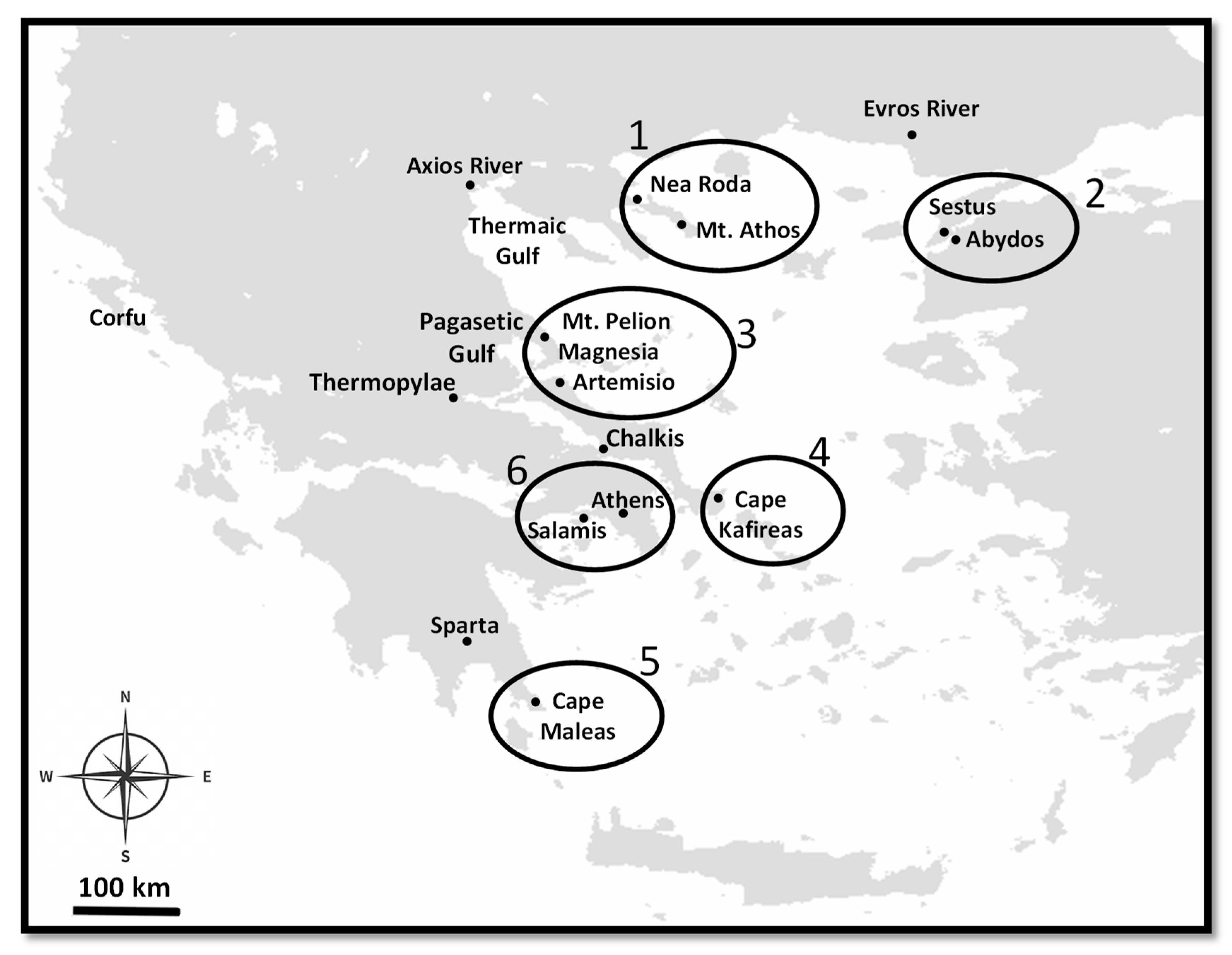
:1. Introduction
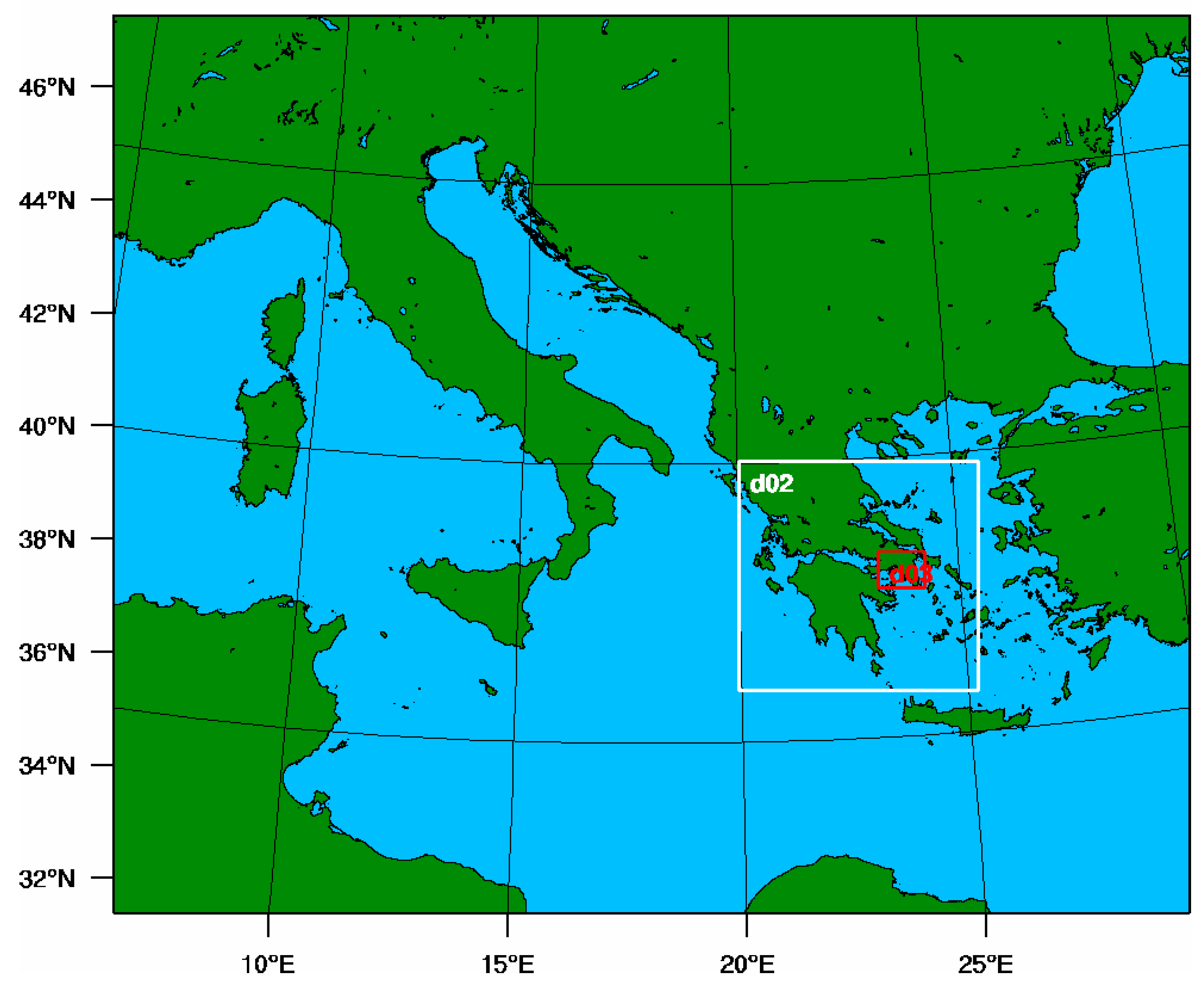
2. Methodology
2.1. Observational Data
2.2. Reanalysis and Modeling
3. Results
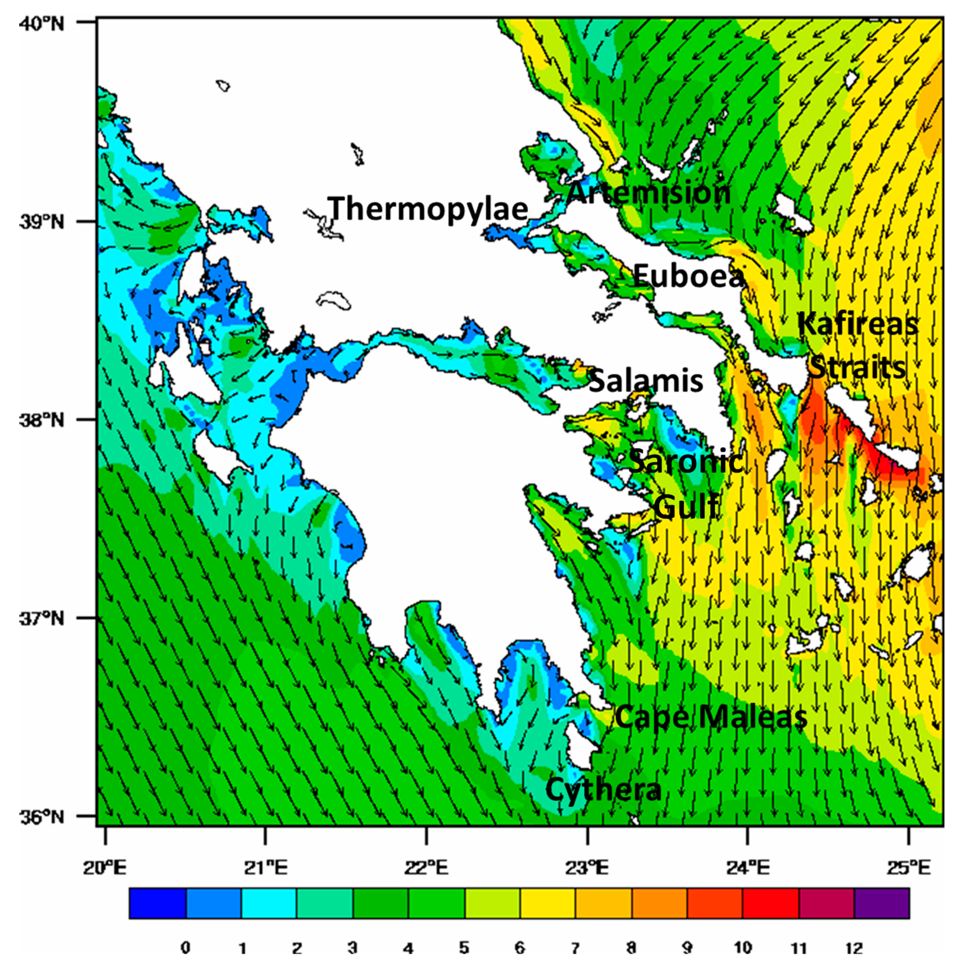
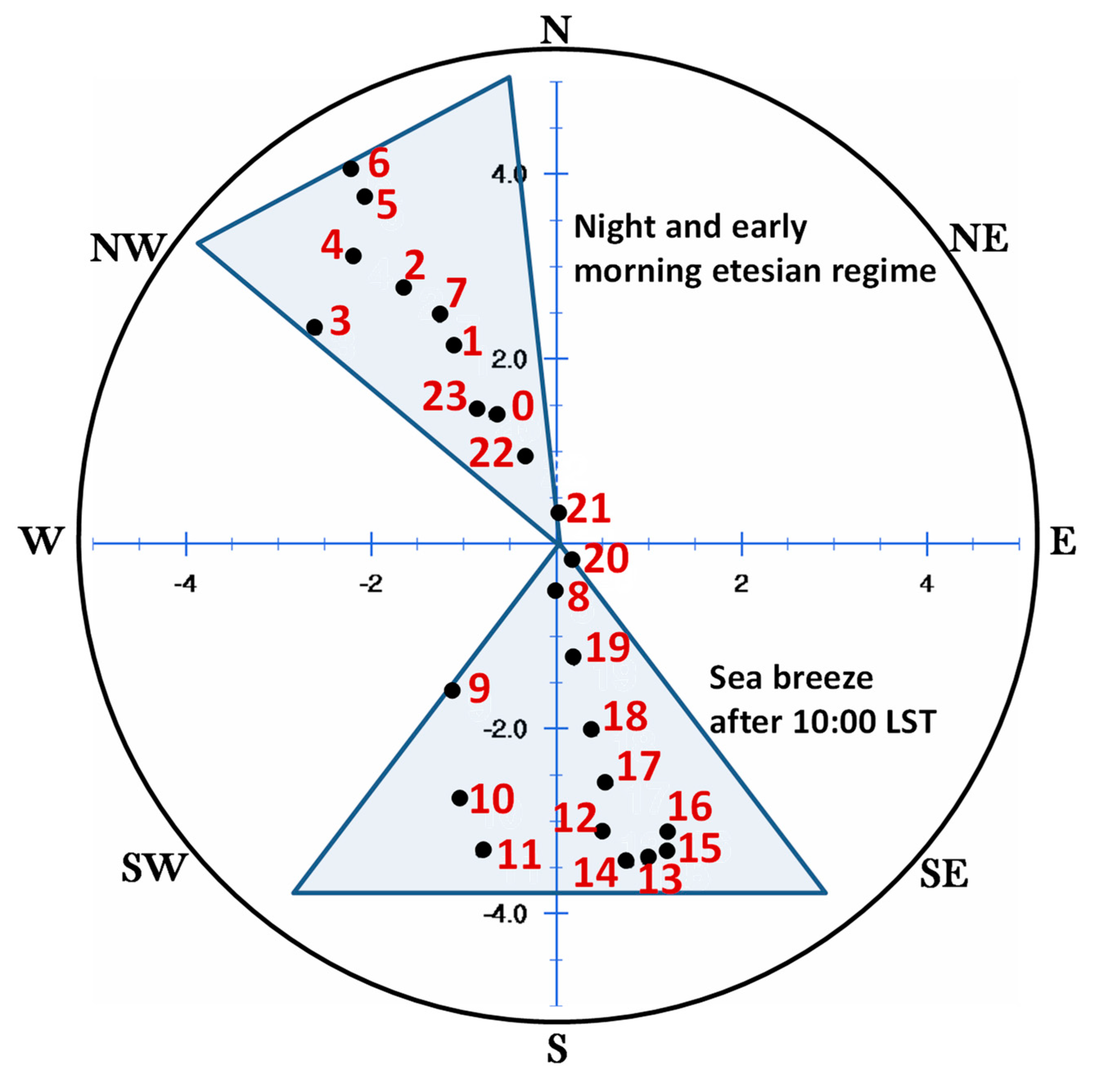
3.1. Climatology of Synoptic Scale Dynamics
3.2. The Course of Weather Conditions during the Battle
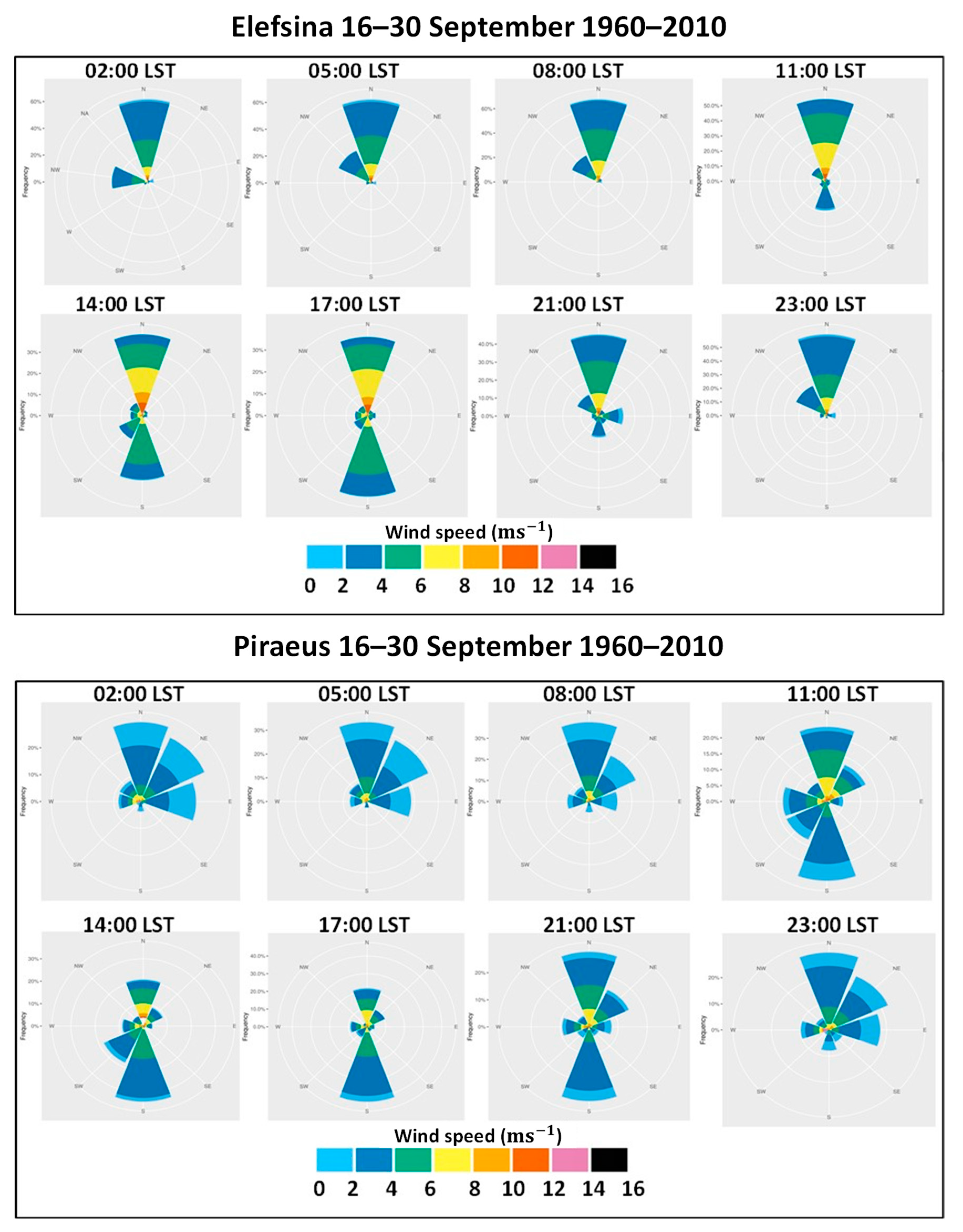
3.2.1. Station Measurements
3.2.2. Model Simulations
Before the Battle
During the Battle
After the Battle
4. Conclusions and Discussion
Author Contributions
Funding
Acknowledgments
Conflicts of Interest
References
- Tsonis, A.; Zerefos, C. “Aristotle’s Μετεωρολογικά: Meteorology Then and Now. Available online: http://www.archaeopress.com/ArchaeopressShop/Public/download.asp?id={F42484FB-B6EB-405C-9E66-4D982C45E746}) (accessed on 10 July 2020).
- Godley, A.D. Herodotus Histories, Books V-VII; Harvard University Press: Cambridge, MA, USA, 1922. [Google Scholar]
- Perrin, B. Plutarch’s Lives; Harvard University Press: Cambridge, MA, USA, 1914. [Google Scholar]
- Godley, A.D. Herodotus Books VIII-IX; Harvard University Press: Cambridge, MA, USA, 1922. [Google Scholar]
- Aeschylus, The Persae; Cambridge University Press: Cambridge, UK, 1960.
- Hersbach, H.; Bell, B.; Berrisford, P.; Hirahara, S.; Horányi, A.; Muñoz-Sabater, J.; Nicolas, J.; Peubey, C.; Radu, R.; Schepers, D.; et al. The ERA5 global reanalysis. Q. J. R. Meteorol. Soc. 2020, 146, 1999–2049. [Google Scholar] [CrossRef]
- Skamarock, W.C.; Klemp, J.B.; Dudhia, J.; Gill, D.O.; Barker, D.M.; Duda, M.G.; Huang, X.Y.; Wang, W.; Powers, J.G. A Description of the Advanced Research WRF Version 3. Available online: https://opensky.ucar.edu/islandora/object/technotes%3A500/datastream/PDF/view (accessed on 10 July 2020).
- Melas, D.; Ziomas, I.; Klemm, O.; Zerefos, C. Anatomy of the sea-breeze circulation in Athens area under weak large-scale ambient winds. Atmos. Environ. 1998, 32, 2223–2237. [Google Scholar] [CrossRef]
- Melas, D.; Ziomas, I.; Klemm, O.; Zerefos, C. Flow dynamics in Athens area under moderate large-scale winds. Atmos. Environ. 1998, 32, 2209–2222. [Google Scholar] [CrossRef]
- Repapis, C.; Zerefos, C.S.; Tritakis, B. On the Etesians over the Aegean. Proc. Acad. Athens 1977, 52, 572–606. [Google Scholar]
- Hammond, N.G.L. The Battle of Salamis. J. Hell. Stud. 1956, 76, 32–54. [Google Scholar] [CrossRef]
- Morton, J. The Role of the Physical Environment in Ancient Greek Seafaring; Brill: Leiden, The Netherlands, 2001. [Google Scholar]
- Maheras, P. Le probleme des Etesiens. Mediterranee 1980, 40, 57–66. [Google Scholar] [CrossRef]
- Kallos, G.; Kassomenos, P.; Pielke, R.A. Synoptic and mesoscale weather conditions during air pollution episodes in Athens, Greece. Bound. Layer Meteorol. 1993, 63, 163–184. [Google Scholar] [CrossRef]
- Poupkou, A.; Zanis, P.; Nastos, P.; Papanastasiou, D.; Melas, D.; Tourpali, K.; Zerefos, C. Present climate trend analysis of the Etesian winds in the Aegean Sea. Theor. Appl. Climatol. 2011, 106, 459–472. [Google Scholar] [CrossRef]
- Tyrlis, E.; Lelieveld, J. Climatology and dynamics of the summer Etesian winds over the eastern Mediterranean. J. Atmos. Sci. 2013, 70, 3374–3396. [Google Scholar] [CrossRef]
- Dafka, S.; Xoplaki, E.; Toreti, A.; Zanis, P.; Tyrlis, E.; Zerefos, C.; Luterbacher, J. The Etesians: From observations to reanalysis. Clim. Dyn. 2016, 47, 1569–1585. [Google Scholar] [CrossRef]


| Hour (LST) | Climatological Wind Regimes | Ancient Source |
|---|---|---|
| 00:00–07:00 | NW winds up to 3–4 ms−1 possibly assist the Persians to take battle positions during the night without being noticed by the Greeks. In addition, Aristides manages to pass unnoticed through the Persian ships and join the Greek fleet | [4] (Hdt. 70.) (…So when they passed the word to put out to sea, they brought their ships out to Salamis and quietly ranged themselves along the shore in their several positions…) [4] (Hdt. 76.) (…These things they did in silence, so that the enemy might not take any notice of them….) [4] (Hdt. 81.) (….Aristides accordingly came forward and told them that he had come from Aegina and had escaped with difficulty without being perceived by those who were blockading them….) |
| 07:00–09:00 | Preparations and speeches delay the beginning of the battle by 1–2 h. At the time between sunrise (~07:15 LST) and embarkation, another trireme covers the 10-mile distance from Aegina towards Salamis (a trip of about 1–1.5 h, bearing in mind an average trireme speed of 8–10 miles per hour). | [4] (Hdt.83.) (….at the break of dawn, they made an assembly of those who fought on board the ships and addressed them, Themistocles made a speech which was the most eloquent of all; [….] and thus having wound up his speech, he ordered them to board their ships. These then proceeded to embark, and in the meantime, the trireme which had gone away to bring the sons of Aiacos came from Aegina….) |
| 09:00–10:00 | At first light, the Greek ships, instead of trying to escape (as the Persians would have expected), appear in perfect battle formation and their war paean echoes on the rocks of Salamis The Greeks delay their counterattack by backing towards the shore. This was most probably part of their strategic plan to lure the Persians further into the narrow channel while also waiting for the sea breeze to take effect | [5] (Aeschylus, Persae 386) (….Advance, ye sons of Greece, free your country, free your wives, your children, the temples of your gods and the sacred tombs of your ancestors; now the fight is for all of them….) “Ὦ παῖδες Ἑλλήνων ἴτε, ἐλευθεροῦτε πατρίδ’, ἐλευθεροῦτε δὲ παῖδας, γυναῖκας, θεῶν τέ πατρῴων ἕδη, θήκας τε προγόνων· νῦν ὑπὲρ πάντων ἀγών.” [4] (Hdt. 84.) (…Then the Hellenes put out all their ships, and while they were putting out from shore, the Barbarians attacked them immediately. Now the other Hellenes began backing their ships and were about to run them aground […] It is also reported that an apparition of a woman was seen by them, and that when she appeared, she encouraged them to the fight so that the whole of the army of the Hellenes heard it, while she reproached them in these words: “Madmen, how far will you still back your ships?”….) “Ὦ δαιμόνιοι, μέχρι κόσου ἔτι πρύμνην ἀνακρούεσθε;” |
| ~10:00 | The Greeks counterattack at the same time as the wind changes from NW to SE | [3] (Plut. Them. 14.) (…Themistocles made sure that the Greek ships were lined up opposite the Persian ones at the specific time when a strong wind blew from the sea bringing waves to the straits…) “ἢ τὴν εἰωθυῖαν ὥραν παραγενέσθαι, τὸ πνεῦμα λαμπρὸν ἐκ πελάγους ἀεὶ καὶ κῦμα διὰ τῶν στενῶν κατάγουσαν” |
| 10:00–11:00 | At the beginning of the sea-battle the Corinthians are accused of putting up sails towards Elefsis. This would only be possible under a southeast sea breeze. | [4] (Hdt. 94.) (…As regards Adeimantos, the commander of the Corinthians, the Athenians say that right at the beginning when the ships were engaging in the fight, being struck with panic and terror he put up his sails and fled away; and when the Corinthians saw the admiral’s ship fleeing, they departed likewise….) |
| 11:00–19:00 | The battle takes place under sea breeze conditions. The incoming southeast wind flow into Salamis Straits possibly contributes to the disorganization of the Persian fleet by steering the higher Persian ships perpendicularly to the rams of the Greek triremes. The strengthening southeast sea breeze does not allow the Persians to hoist sails for a fast retreat towards the open Saronic Gulf. They are not able to reform and counterattack or to transfer the conflict to the open sea. The turmoil in the narrow straits increases and the Persian fleet is trapped in a “pincer” created by the Greek fleet with the aid of the local winds. | [4] (Hdt. 86.) (…because the Hellenes fought in order and ranged in their places, while the Barbarians were no longer ranged in order nor did anything with design …) [3] (Pl. Them. 14) (…The wind falling on the higher Persian decks steered them and offered their sides to the attacking Greek ships…) “ καὶ τοῖς καταστρώμασιν ὑψορόφους καὶ βαρείας ἐπιφερομένας ἔσφαλλε προςπίπτον, καὶ παρεδίδου πλαγίας τοῖς Ἕλλησιν ὀξέως προςφερομένοις ” |
| 19:00 until the next morning | After sunset (~19:15 LST) the battle wrecks are taken by the west wind “Zephyrus” towards the coasts of Attica | [4] (Hdt.96.) (…. many of the wrecks were taken by Zephyrus and brought to that strand in Attica which is called Colias…) “τῶν δὲ ναυηγίων πολλὰ ὑπολαβὼν ἄνεμος ζέφυρος ἔφερε τῆς Ἀττικῆς ἐπὶ τὴν ἠιόνα τὴν καλεομένην Κωλιάδα” |
© 2020 by the authors. Licensee MDPI, Basel, Switzerland. This article is an open access article distributed under the terms and conditions of the Creative Commons Attribution (CC BY) license (http://creativecommons.org/licenses/by/4.0/).
Share and Cite
Zerefos, C.; Solomos, S.; Melas, D.; Kapsomenakis, J.; Repapis, C. The Role of Weather during the Greek–Persian “Naval Battle of Salamis” in 480 B.C. Atmosphere 2020, 11, 838. https://doi.org/10.3390/atmos11080838
Zerefos C, Solomos S, Melas D, Kapsomenakis J, Repapis C. The Role of Weather during the Greek–Persian “Naval Battle of Salamis” in 480 B.C. Atmosphere. 2020; 11(8):838. https://doi.org/10.3390/atmos11080838
Chicago/Turabian StyleZerefos, Christos, Stavros Solomos, Dimitris Melas, John Kapsomenakis, and Christos Repapis. 2020. "The Role of Weather during the Greek–Persian “Naval Battle of Salamis” in 480 B.C." Atmosphere 11, no. 8: 838. https://doi.org/10.3390/atmos11080838