


Dynamics of Forest Vegetation in an Urban Agglomeration Based on Landsat Remote Sensing Data for the Period 1990–2022: A Case Study
 ,
,
Abstract
:1. Introduction
2. Background
3. Materials
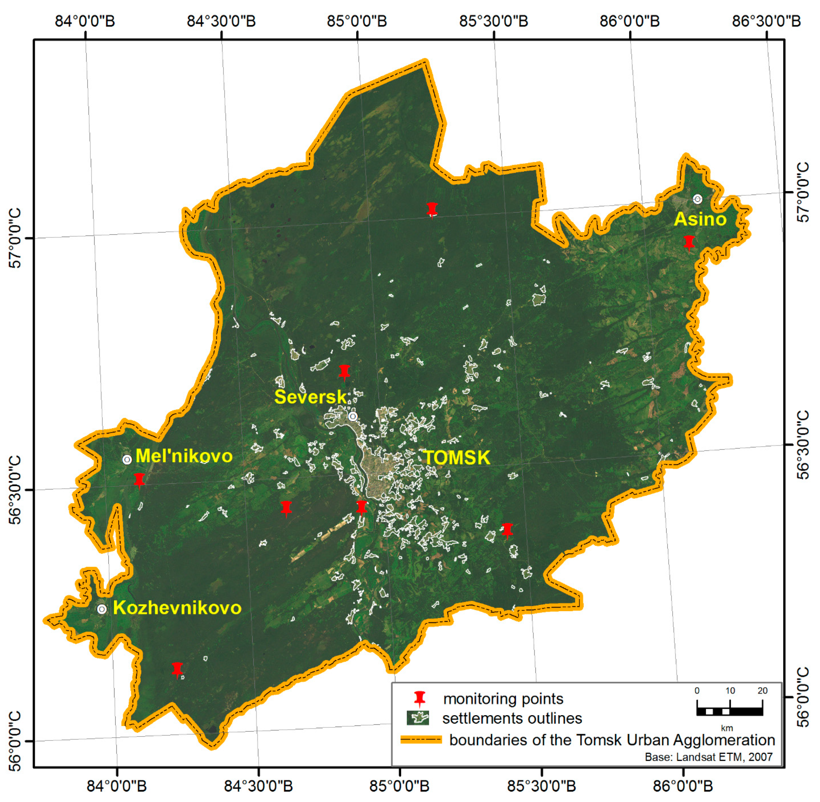
3.1. Study Area
3.2. Data
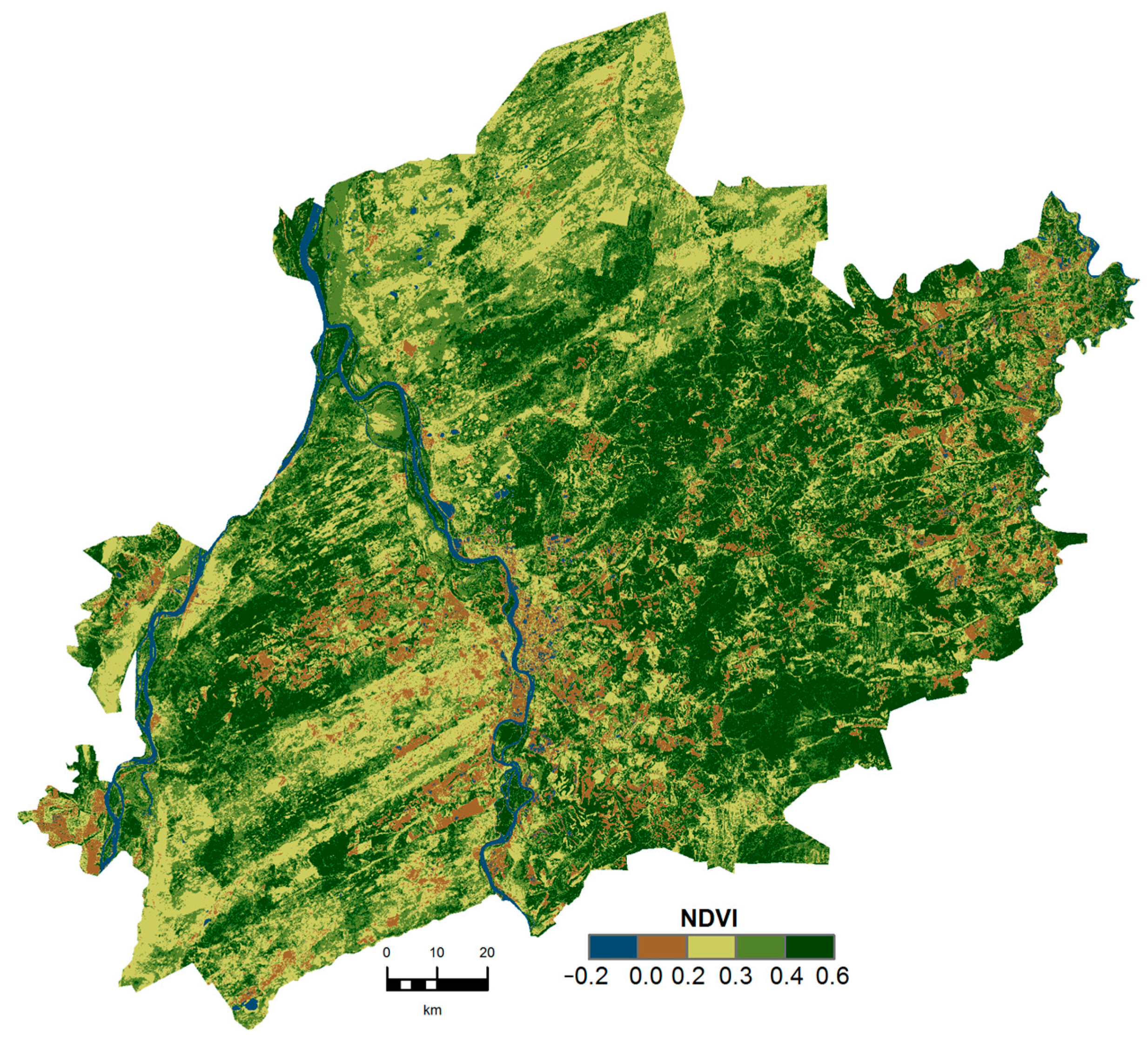
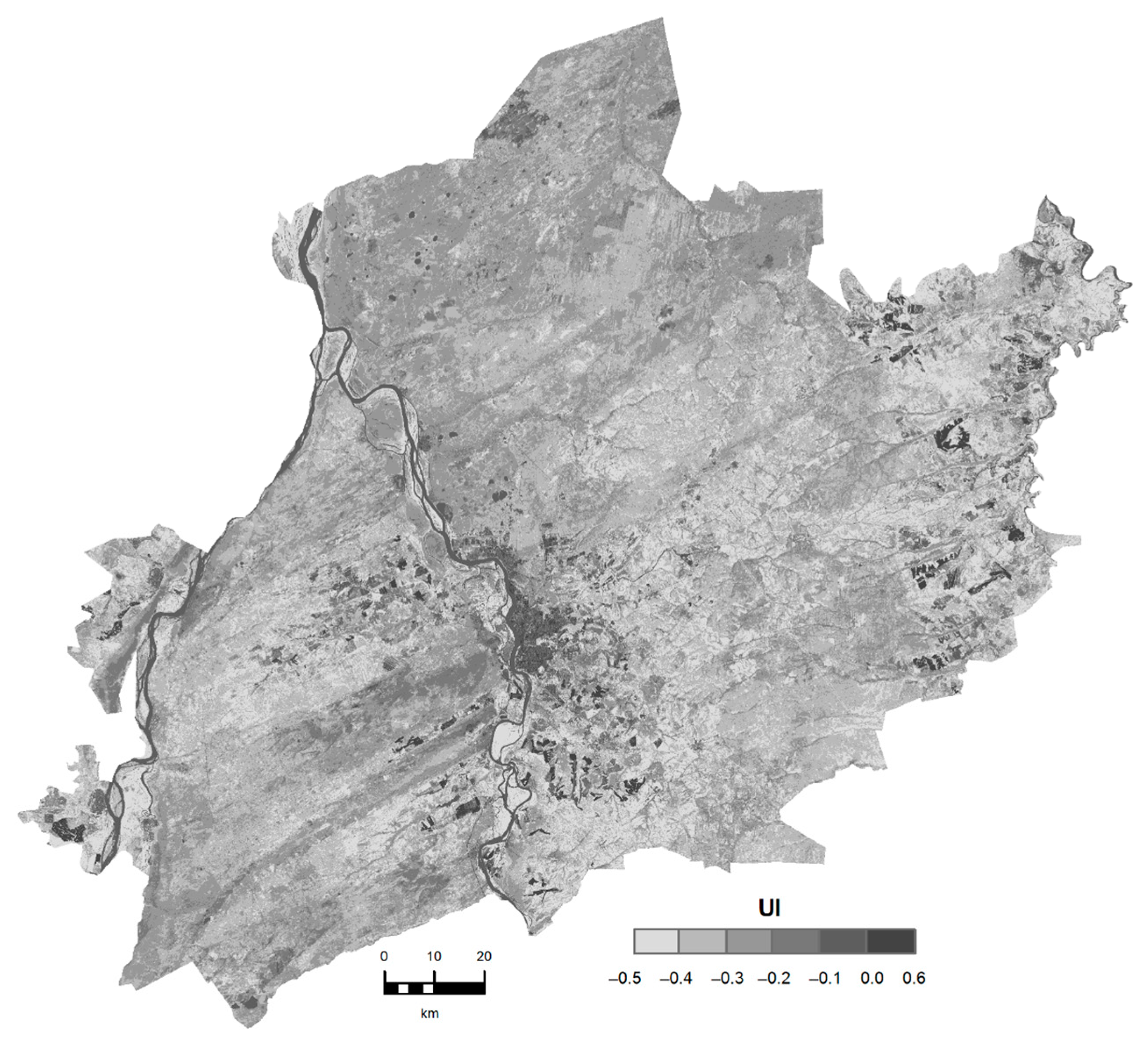
3.3. Spectral Indexes
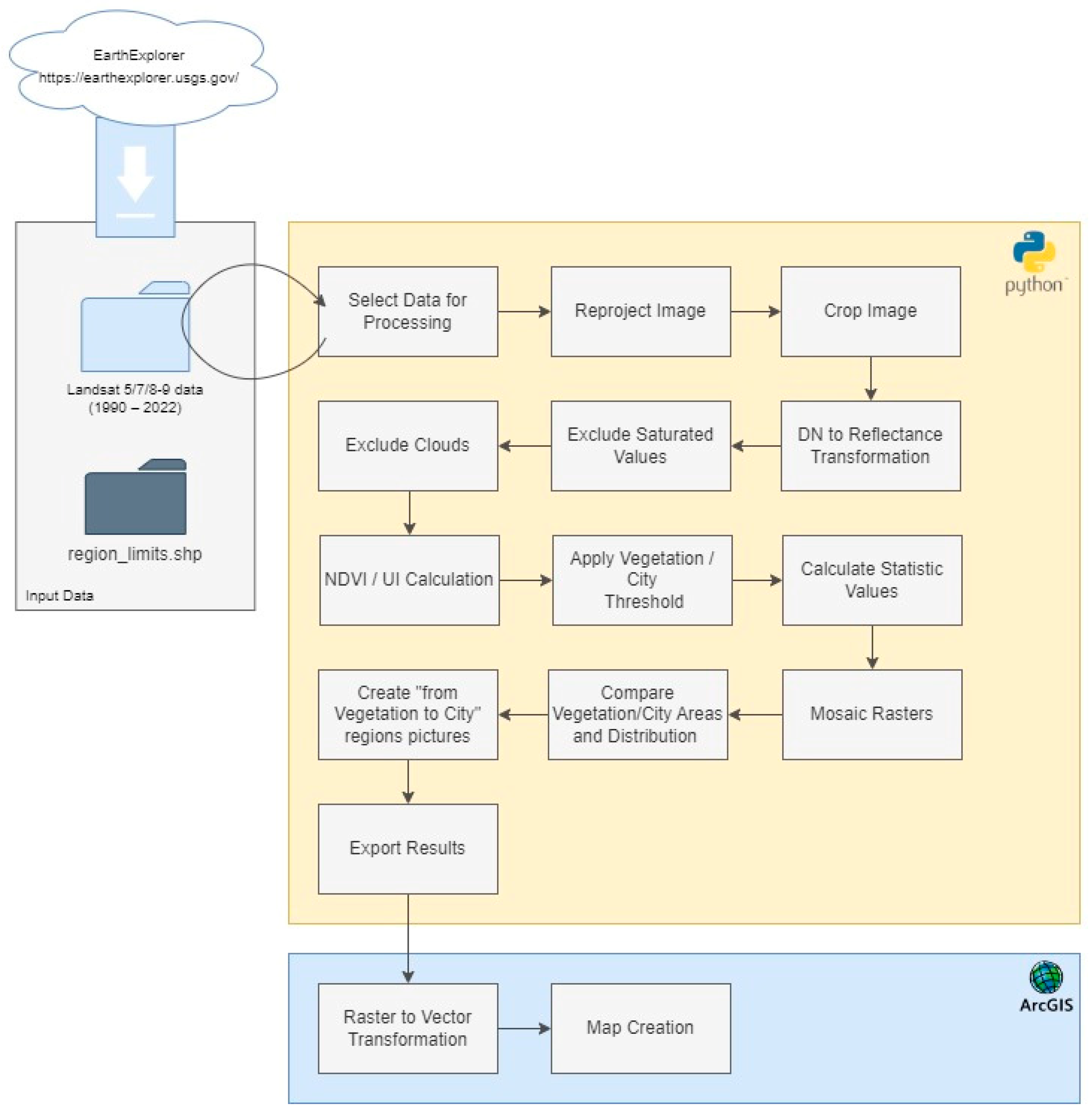
4. Methods
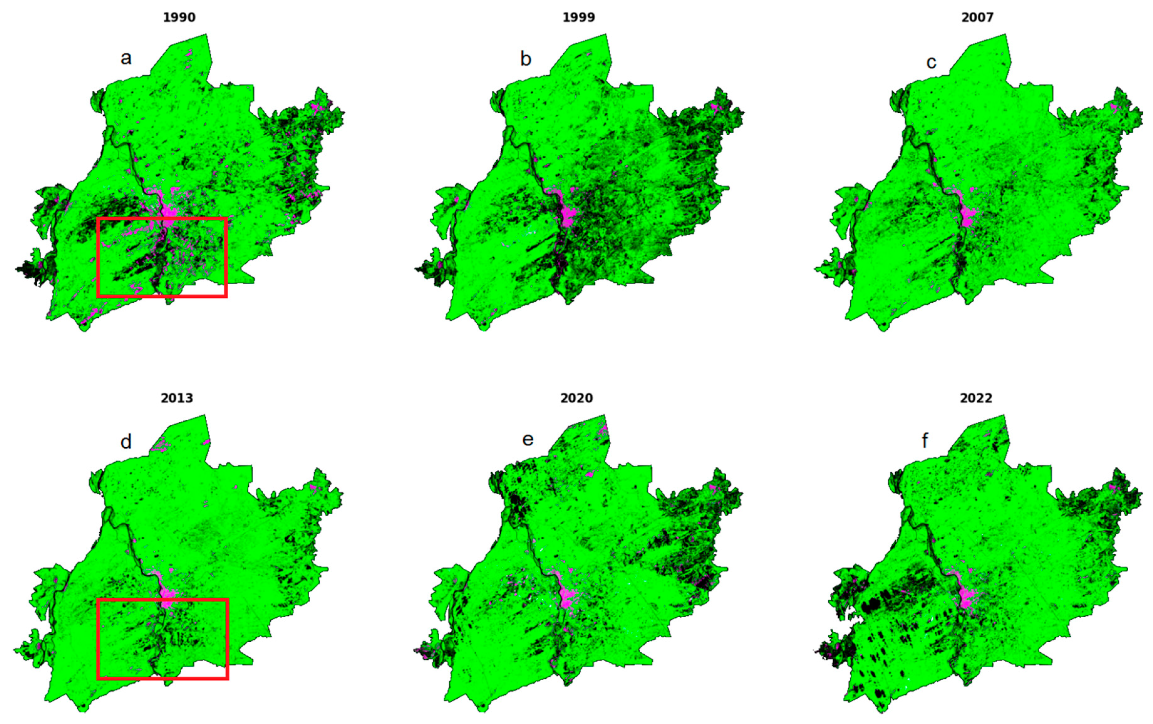
5. Results and Discussion
6. Conclusions
Author Contributions
Funding
Data Availability Statement
Conflicts of Interest
References
- Jingyi Yang, J.; Wang, Z.; Pan, Y. Shifts in plant ecological strategies in remnant forest patches along urbanization gradients. For. Ecol. Manag. 2022, 524, 120540. [Google Scholar] [CrossRef]
- Veselkin, D.V. Urbanization increases the range, but not the depth, of forest edge influences on Pinus sylvestris bark pH. Urban For. Urban Greening 2022, 79, 127819. [Google Scholar] [CrossRef]
- Mitchell, M.G.E.; Devisscher, T. Strong relationships between urbanization, landscape structure, and ecosystem service multifunctionality in urban forest fragments. Landsc. Urban Plan. 2022, 228, 104548. [Google Scholar] [CrossRef]
- Chen, X.; Zhang, X.; Wei, H. Urbanization induced changes in the accumulation mode of organic carbon in the surface soil of subtropical forests. CATENA 2022, 214, 106264. [Google Scholar] [CrossRef]
- Vacca, P.; Caballero, D.; Planas, E. WUI fire risk mitigation in Europe: A performance-based design approach at home-owner level. J. Saf. Sci. Resil. 2020, 1, 97–105. [Google Scholar] [CrossRef]
- Vaiciulyte, S.; Hulse, L.M.; Veeraswamy, A. Exploring ‘wait and see’ responses in French and Australian WUI wildfire emergencies. Saf. Sci. 2022, 155, 105866. [Google Scholar] [CrossRef]
- Hysa, A. Indexing the vegetated surfaces within WUI by their wildfire ignition and spreading capacity, a comparative case from developing metropolitan areas. Int. J. Disaster Risk Reduct. 2021, 63, 102434. [Google Scholar] [CrossRef]
- Pohjola, J.; Turunen, J.; Ikonen, A.T.K. On the inclusion of forest exposure pathways into a stylized lake-farm scenario in a geological repository safety analysis. J. Environ. Radioact. 2022, 255, 107019. [Google Scholar] [CrossRef]
- Ahmadvand, S.; Khadivi, M.; Sowlati, T. Bi-objective optimization of forest-based biomass supply chains for minimization of costs and deviations from safety stock. Energy Convers. Manag. 2021, 11, 100101. [Google Scholar] [CrossRef]
- Unver, S.; Ergenc, I. Safety risk identification and prioritize of forest logging activities using analytic hierarchy process (AHP). Alex. Eng. J. 2020, 60, 1591–1599. [Google Scholar] [CrossRef]
- Barta, K.A.; Hais, M.; Heurich, M. Characterizing forest disturbance and recovery with thermal trajectories derived from Landsat time series data. Remote Sens. Environ. 2022, 282, 113274. [Google Scholar] [CrossRef]
- Viana-Soto, A.; Okujeni, A.; Hostert, P. Quantifying post-fire shifts in woody-vegetation cover composition in Mediterranean pine forests using Landsat time series and regression-based unmixing. Remote Sens. Environ. 2022, 281, 113239. [Google Scholar] [CrossRef]
- Maeda, E.E.; Formaggio, A.R.; Hansen, M.C. Predicting forest fire in the Brazilian Amazon using MODIS imagery and artificial neural networks. Int. J. Appl. Earth Obs. Geoinf. 2009, 11, 265–272. [Google Scholar] [CrossRef]
- Silveira, E.M.O.; Radeloff, V.C.; Pidgeon, A.M. Nationwide native forest structure maps for Argentina based on forest inventory data, SAR Sentinel-1 and vegetation metrics from Sentinel-2 imagery. Remote Sens. Environ. 2022, 285, 113391. [Google Scholar] [CrossRef]
- Eskandari, S.; Sarab, S.A.M. Mapping land cover and forest density in Zagros forests of Khuzestan province in Iran: A study based on Sentinel-2, Google Earth and field data. Ecol. Inform. 2022, 70, 101727. [Google Scholar] [CrossRef]
- Do-Hyung, K.; Joseph, O.; Sexton, P.N.; Chengquan, H.; AnupamAnand, S.C.; Feng, M.; John, R. Townshcnd Global, Landsat-based forest-cover change from 1990 to 2000. Remote Sens. Environ. 2014, 155, 178–193. [Google Scholar]
- Yankovich, K.S.; Yankovich, E.P.; Baranovskiy, N.V. Classification of Vegetation to Estimate Forest Fire Danger Using Landsat 8 Images: Case Study (2019). Math. Probl. Eng. 2019, 6296417. [Google Scholar] [CrossRef]
- Baranovskiy, N.V.; Yankovich, K.S.; Yankovich, E.P. Preliminary estimation of forest fire danger using LANDSAT images over Baikal Lake basin forests (2018). In Proceedings of the 24th International Symposium on Atmospheric and Ocean Optics: Atmospheric Physics, Tomsk, Russian, 13 December 2018; p. 10833. [Google Scholar]
- Zhou, X.; Hao, Y.; Di, L.; Wang, X.; Chen, C.; Chen, Y.; Nagy, G.; Jancso, T. Improving GEDI Forest Canopy Height Products by Considering the Stand Age Factor Derived from Time-Series Remote Sensing Images: A Case Study in Fujian, China. Remote Sens. 2023, 15, 467. [Google Scholar] [CrossRef]
- Shamsuzzoha, M.; Ahamed, T. Shoreline Change Assessment in the Coastal Region of Bangladesh Delta Using Tasseled Cap Transformation from Satellite Remote Sensing Dataset. Remote Sens. 2023, 15, 295. [Google Scholar] [CrossRef]
- Ullah, W.; Ahmad, K.; Ullah, S.; Tahir, A.A.; Javed, M.F.; Nazir, A.; Abbasi, A.M.; Aziz, M.; Mohamed, A. Analysis of the relationship among land surface temperature (LST), land use land cover (LULC), and normalized difference vegetation index (NDVI) with topographic elements in the lower Himalayan region. Heliyon 2023, 9, e13322. [Google Scholar] [CrossRef]
- ENVI—Image Processing and Analysis Software Solution. Available online: https://www.ittvis.com/envi/ (accessed on 14 January 2023).
- ScanEx Image Processor. Available online: https://www.scanex.ru/software/obrabotka-izobrazheniy/scanex-image-processor/ (accessed on 14 January 2023).
- SARproZ. Available online: https://www.scanex.ru/software/obrabotka-izobrazheniy/sarproz/ (accessed on 14 January 2023).
- Python. Available online: https://www.python.org/ (accessed on 14 January 2023).
- Michael, A.; Wulder, J.C.; White, S.N.; Goward, J.G.; Masek, J.R.; Irons, M.H.; Warren, B.; Cohen, T.R.; Loveland, C.E. Woodcock, Landsat continuity: Issues and opportunities for land cover monitoring. Remote Sens. Environ. 2008, 112, 955–969. [Google Scholar] [CrossRef]
- Landsat Satellite Missions. Available online: https://www.usgs.gov/landsat-missions/landsat-satellite-missions (accessed on 27 December 2022).
- Michael, A.; Wulder, D.P.; Roy, V.C.; Radeloff, T.R.; Loveland, M.C.; Anderson, D.M.; Johnson, S.H.; Zhu, Z.; Theodore, A.; Scambos, N.P.; et al. Cook, Fifty years of Landsat science and impacts. Remote Sens. Environ. 2022, 280, 113195. [Google Scholar] [CrossRef]
- Landsat Collection 2. Available online: https://www.usgs.gov/landsat-missions/landsat-collection-2 (accessed on 27 December 2022).
- Phiri, D.; Simwanda, M.; Salekin, S.; Nyirenda, V.R.; Murayama, Y.; Ranagalage, M. Sentinel-2 Data for Land Cover/Use Mapping: A Review. Remote Sens. 2020, 12, 2291. [Google Scholar] [CrossRef]
- Morell-Monzó, S.; Estornell, J.; Sebastiá-Frasquet, M.-T. Comparison of Sentinel-2 and High-Resolution Imagery for Mapping Land Abandonment in Fragmented Areas. Remote Sens. 2020, 12, 2062. [Google Scholar] [CrossRef]
- Dara, A.; Baumann, M.; Kuemmerle, T.; Pflugmacher, D.; Rabe, A.; Griffiths, P.; Hölzel, N.; Kamp, J.; Freitag, M.; Hostert, P. Mapping the timing of cropland abandonment and recultivation in northern Kazakhstan using annual Landsat time series. Remote Sens. Environ. 2018, 213, 49–60. [Google Scholar] [CrossRef]
- Müller, D.; Leitão, P.J.; Sikor, T. Comparing the determinants of cropland abandonment in Albania and Romania using boosted regression trees. Agric. Syst. 2013, 117, 66–77. [Google Scholar] [CrossRef]
- Yin, H.; Prishchepov, A.V.; Kuemmerle, T.; Bleyhl, B.; Buchner, J.; Radeloff, V.C. Mapping agricultural land abandonment from spatial and temporal segmentation of Landsat time series. Remote Sens. Environ. 2018, 210, 12–24. [Google Scholar] [CrossRef]
- Kuemmerle, T.; Hostert, P.; Radeloff, V.C.; Linden, S.; Perzanowski, K.; Kruhlov, I. Cross-border Comparison of Post-socialist Farmland Abandonment in the Carpathians. Ecosystems 2008, 11, 614–628. [Google Scholar] [CrossRef]
- Grădinaru, S.R.; Kienast, F.; Psomas, A. Using multi-seasonal Landsat imagery for rapid identification of abandoned land in areas affected by urban sprawl. Ecol. Indic. 2019, 96, 79–86. [Google Scholar] [CrossRef]
- Prishchepov, A.V.; Radeloff, V.C.; Dubinin, M.; Alcantara, C. The effect of Landsat ETM/ETM image acquisition dates on the detection of agricultural land abandonment in Eastern Europe. Remote Sens. Environ. 2012, 126, 195–209. [Google Scholar] [CrossRef]
- Baumann, M.; Kuemmerle, T.; Elbakidze, M.; Ozdogan, M.; Radeloff, V.C.; Keuler, N.S.; Prishchepov, A.V.; Kruhlov, I.; Hostert, P. Patterns and drivers of post-socialist farmland abandonment in Western Ukraine. Land Use Policy 2011, 28, 552–562. [Google Scholar] [CrossRef]
- Koroleva, N.V.; Tihonova, E.V.; Ershov, D.V.; Saltykov, A.N.; Gavrilyuk, E.A.; Pugachevskij, A.V. Ocenka masshtabov zarastaniya nelesnyh zemel’ v nacional’nom parke “Smolenskoe poozer’e” za 25 let po sputnikovym dannym Landsat (Assessment of the extent of non-forest lands growing in the Smolensk Lakeland National Park for 25 years using satellite data Landsat). Lesovedenie 2018, 2, 83–96. [Google Scholar]
- Phiri, D.; Morgenroth, J. Developments in Landsat Land Cover Classification Methods: A Review. Remote Sens. 2017, 9, 967. [Google Scholar] [CrossRef] [Green Version]
- Schowengerdt, R.A. Techniques for Image Processing and Classifications in Remote Sensing; Academic Press: Cambridge, MA, USA, 2012. [Google Scholar]
- Potapov, P.; Turubanova, S.; Matthew, C. Hansen, Regional-scale boreal forest cover and change mapping using Landsat data composites for European Russia. Remote Sens. Environ. 2011, 115, 548–561. [Google Scholar] [CrossRef]
- Campbell, J.B.; Wynne, R.H. Introduction to Remote Sensing; Guilford Press: New York, NY, USA, 2011; Volume 5. [Google Scholar]
- Lu, D.; Weng, Q. A survey of image classification methods and techniques for improving classification performance. Int. J. Remote Sens. 2007, 28, 823–870. [Google Scholar] [CrossRef]
- Coppin, P.; Jonckheere, I.K.; Nackaerts, B.; Muys, E. Lambin Review Digital change detection methods in ecosystem monitoring: A review. Int. J. Remote Sens. 2004, 25, 1565–1596. [Google Scholar] [CrossRef]
- Yeprintsev, S.A.; Klepikov, O.V.; Shekoyan, S.V. Remote sensing of the Earth as a method of assessing environmental quality of urban areass. Zdo rov’e Naseleniya i Sreda. Obitaniya 2020, 4, 5–12. [Google Scholar] [CrossRef]
- Guindon, B.; Zhang, Y.; Dillabaugh, C. Landsat urban mapping based on a combined spectral–spatial methodology. Remote Sens. Environ. 2004, 92, 218–232. [Google Scholar] [CrossRef]
- Masek, J.G.; Lindsay, F.E.; Goward, S.N. Dynamics of urban growth in the Washington DC Metropolitan Area, 1973–1996, from Landsat observations. Int. J. Remote Sens. 2000, 21, 3473–3486. [Google Scholar] [CrossRef]
- Chai, B.; Li, P. An ensemble method for monitoring land cover changes in urban areas using dense Landsat time series data. ISPRS J. Photogramm. Remote Sens. 2023, 195, 29–42. [Google Scholar] [CrossRef]
- Schneider, A. Monitoring land cover change in urban and peri-urban areas using dense time stacks of Landsat satellite data and a data mining approach. Remote Sens. Environ. 2012, 124, 689–704. [Google Scholar] [CrossRef]
- Czekajlo, A.; Nicholas, C.; Coops, M.A.; Wulder, T.H.; Joanne, C. Matilda van den Bosch, W. Mapping dynamic peri-urban land use transitions across Canada using Landsat time series: Spatial and temporal trends and associations with socio-demographic factors. Computers Environ. Urban Syst. 2021, 88, 101653. [Google Scholar] [CrossRef]
- Zha, Y.; Gao, J.; Ni, S. Use of normalized difference built-up index in automatically mapping urban areas from TM imagery. Int. J. Remote Sens. 2003, 24, 583–594. [Google Scholar] [CrossRef]
- Ridd, M.K. Exploring a V-I-S (vegetation-impervious surface-soil) model for urban ecosystem analysis through remote sensing: Comparative anatomy for cities. Int. J. Remote Sens. 1995, 16, 2165–2185. [Google Scholar] [CrossRef]
- Curtis, E.; Woodcock, T.R.; Loveland, M.H.; Bauer, M.E. Transitioning from change detection to monitoring with remote sensing: A paradigm shift. Remote Sens. Environ. 2020, 238, 111558. [Google Scholar] [CrossRef]
- Draft Scheme of Territorial Planning of the Tomsk Region. Explanatory Note. Volume 1 “Regulations on Territorial Planning”. Available online: https://tomsk.gov.ru/tomskaja-aglomeratsija (accessed on 15 December 2022). (In Russian)
- Dyukarev, A.G.; Pologova, N.N.; Lapshina, E.D. Natural Resource Zoning of the Tomsk Region; Spektr Publishing House: Tomsk, Russia, 1997; p. 40. [Google Scholar]
- Evseeva, N.S. Geography of the Tomsk Region. (Natural Conditions and Resources); Publishing House of Tomsk University: Tomsk, Russia, 2001; p. 223. [Google Scholar]
- USGS. Available online: https://earthexplorer.usgs.gov/ (accessed on 14 January 2023).
- Elmore, A.; Mustard, J.F.; Manning, S.J.; Lobell, D.B. Quantifying vegetation change in semiarid Environments: Precision and accuracy of spectral mixture analysis and the Normalized Difference Vegetation Index. Remote Sens. Environ. 2000, 73, 87–102. [Google Scholar] [CrossRef]
- Howard, J.A. Remote Sensing of Forest Resources: Theory and Application; Chapman & Hall: New York, NY, USA, 1991; p. 420. [Google Scholar]
- Rouse, J.W.; Haas, R.H.; Schell, J.A.; Deering, D.W. Monitoring vegetation systems in the Great Plains with ERTS. Third ERTS Symp. NASA 1973, 351, 309–317. [Google Scholar]
- Gao, B.C. NDWI—A Normalized Difference Water Index for Remote Sensing of Vegetation Liquid Water from Space. Remote Sens. Environ. 1996, 58, 257–266. [Google Scholar] [CrossRef]
- McFeeters, S.K. The use of the normalized difference water index (NDWI) in the delineation of open water features. Int. J. Remote Sens. 1996, 17, 1425–1432. [Google Scholar] [CrossRef]
- Kawamura, M.; Jayamana, S.; Tsujiko, Y. Relation between social and environmental conditions in Colombo Sri Lanka and the urban index estimated by satellite remote sensing data. Int. Arch. Photogramm. Remote Sens. 1996, 31, 321–326. [Google Scholar]
- Kawamura, M.; Jayamanna, S.; Tsujiko, Y. Quantitative evaluation of urbanization in developing countries using satellite data. J. Environ. Syst. Eng. 1997, 580, 45–54. [Google Scholar] [CrossRef] [PubMed] [Green Version]
- Kawamura, M.; Jayamanna, S.; Tsujiko, Y.; Sugiyama, A. Comparison of urbanization of four Asian cities using satellite data. J. Environ. Syst. Eng. 1998, 608, 97–105. [Google Scholar] [CrossRef] [PubMed] [Green Version]
- Available online: https://landsat.usgs.gov/landsat-8-l8-data-users-handbook (accessed on 27 December 2022).
- Abdelal, R. National Purpose in the World Economy: Post-Soviet States in Comparative Perspective; Cornell University Press: Ithaca, NY, USA, 2005. [Google Scholar]
- Kot, V.; Barsukova, A.; Strielkowski, W.; Krivko, M.; Smutka, L. International Trade in the Post-Soviet Space: Trends, Threats, and Prospects for the Internal Trade within the Eurasian Economic Union. J. Risk Financ. Manag. 2023, 16, 16. [Google Scholar] [CrossRef]
- Forest Code of the Russian Federation of December 4, 2006 N 200-FZ (LK RF) (as amended). Available online: https://base.garant.ru/77707148/ (accessed on 14 January 2023).
- Kuznetsov, G.V.; Baranovskiy, N.V. Focused sun’s rays and forest fire danger: New concept (2013) Proceedings of SPIE. Int. Soc. Opt. Eng. 2013, 8890, 889011. [Google Scholar]
- Bazarova, O.; Bazarov, A.; Baranovskiy, N.; Sychev, R.; Atutov, E. Impact of Population Income on the Number of Forest Fires: A Case Study. Int. Rev. Model. Simul. 2022, 15, 36–46. [Google Scholar] [CrossRef]
- Rehman, A.U.; Mian, S.H.; Usmani, Y.S.; Abidi, M.H.; Mohammed, M.K. Modeling Consequences of COVID-19 and Assessing Its Epidemiological Parameters: A System Dynamics Approach. Healthcare 2023, 11, 260. [Google Scholar] [CrossRef]
- Ettehadi Osgouei, P.; Kaya, S.; Sertel, E.; Alganci, U. Separating Built-Up Areas from Bare Land in Mediterranean Cities Using Sentinel-2A Imagery. Remote Sens. 2019, 11, 345. [Google Scholar] [CrossRef] [Green Version]
- Baranovskiy, N.V.; Karanina, S.Y.; Kocheeva, N.A.; Belikova, M.Y. Lightning discharges distribution estimation over the Tomsk region in 2010–2015 Proceedings of SPIE. Int. Soc. Opt. Eng. 2018, 10833, 108337S. [Google Scholar]
- Buramuge, V.A.; Ribeiro, N.S.; Olsson, L.; Bandeira, R.R.; Lisboa, S.N. Tree Species Composition and Diversity in Fire-Affected Areas of Miombo Woodlands, Central Mozambique. Fire 2023, 6, 26. [Google Scholar] [CrossRef]
- Amroussia, M.; Viedma, O.; Achour, H.; Abbes, C. Predicting Spatially Explicit Composite Burn Index (CBI) from Different Spectral Indices Derived from Sentinel 2A: A Case of Study in Tunisia. Remote Sens. 2023, 15, 335. [Google Scholar] [CrossRef]
- Baranovskiy, N. A simplified mathematical model for estimating the anthropogenic load on forest areas in the context of forest fires. Int. Multidiscip. Sci. GeoConference Surv. Geol. Min. Ecol. Manag. 2019, 19, 723–730. [Google Scholar]
- Baranovskiy, N.V.; Ignateva, A.V. Mathematical Modeling of Human Activity on Forested Areas from Point Objects of Railway Infrastructure in a Two-Dimensional Statement. Int. J. Eng. Appl. 2022, 10, 15–28. [Google Scholar] [CrossRef]
- Podolskaya, A.S.; Ershov, D.V.; Shulyak, P.P. Application of the method for assessing the likelihood of forest fires in ISDM-Rosleskhoz. Mod. Probl. Remote Sens. Earth Space 2011, 8, 118–126. [Google Scholar]
- Rasterio Python Tool. Available online: https://pypi.org/project/rasterio/ (accessed on 8 February 2023).
- Fiona Python Tool. Available online: https://pypi.org/project/Fiona/ (accessed on 8 February 2023).


| Municipality Name | Territory km2 | Population 1 January 2016 |
|---|---|---|
| Tomsk | 297.20 | 590,826 |
| Seversk | 485.65 | 114,549 |
| Tomsk area | 10,035.22 | 72,386 |
| West part of | ||
| Asinovskoe area: | ||
| Asino | 89.85 | 24,615 |
| Bolshedorohovo | 249.97 | 950 |
| Novikovskoe | 272.93 | 1308 |
| Yagodnoe | 297.00 | 1394 |
| Northen East part of | ||
| Kozhevnikovo area: | ||
| Kozhevnikovo | 397.12 | 8351 |
| East part of | ||
| Shegarskiy area: | ||
| Pobeda | 223.41 | 2134 |
| Shegarskoe | 202.30 | 8789 |
| Total agglomeration | 12,550.65 | 825,302 |
| Part of Tomsk region | 3.96% | 76.65% |
| ID | Name | Date | Satellite | Cloud Cover, % | Path/Row |
|---|---|---|---|---|---|
| 1 | LT05_L2SP_148020_19890626_20201008_02_T1 | 26 June 1989 | LANDSAT_5 | 1.0 | 148/20 |
| 2 | LT05_L2SP_148021_19900613_20200915_02_T1 | 13 June 1990 | LANDSAT_5 | 2.0 | 148/21 |
| 3 | LE07_L2SP_147020_19990709_20200918_02_T1 | 9 July 1999 | LANDSAT_7 | 0.0 | 147/20 |
| 4 | LE07_L2SP_147021_19990709_20200918_02_T1 | 9 July 1999 | LANDSAT_7 | 0.0 | 147/21 |
| 5 | LE07_L2SP_149020_19990707_20200918_02_T1 | 7 July 1999 | LANDSAT_7 | 0.0 | 149/20 |
| 6 | LE07_L2SP_149021_19990707_20200918_02_T1 | 7 July 1999 | LANDSAT_7 | 0.0 | 149/21 |
| 7 | LT05_L2SP_148020_20070714_20200830_02_T1 | 14 July 2007 | LANDSAT_5 | 0.0 | 148/20 |
| 8 | LT05_L2SP_148021_20070714_20200830_02_T1 | 14 July 2007 | LANDSAT_5 | 0.0 | 148/21 |
| 9 | LC08_L2SP_148020_20130714_20200912_02_T1 | 14 July 2013 | LANDSAT_8 | 0.9 | 148/20 |
| 10 | LC08_L2SP_148021_20130714_20200912_02_T1 | 14 July 2013 | LANDSAT_8 | 0.01 | 148/21 |
| 11 | LC08_L2SP_148020_20200818_20200823_02_T1 | 18 August 2020 | LANDSAT_8 | 5.1 | 148/20 |
| 12 | LC08_L2SP_148021_20200802_20200914_02_T1 | 2 August 2020 | LANDSAT_8 | 0.09 | 148/21 |
| 13 | LC09_L2SP_148020_20220613_20220615_02_T1 | 13 June 2022 | LANDSAT_9 | 1.74 | 148/20 |
| 14 | LC08_L2SP_149021_20220612_20220617_02_T1 | 12 June 2022 | LANDSAT_8 | 9.88 | 149/21 |
| 15 | LC09_L2SP_147021_20220809_20220811_02_T1 | 9 August 2022 | LANDSAT_9 | 1.2 | 147/21 |
| Band | Landsat 5 TM | LANDSAT 7 ETM+ | Landsat 8/9 OLI |
|---|---|---|---|
| Band number: Wavelength | Band number: Wavelength | Band number: Wavelength | |
| Blue | Band 1: 0.45–0.52 | Band 1: 0.45–0.52 | Band 2: 0.45–0.51 |
| Green | Band 2: 0.52–0.60 | Band 2: 0.52–0.60 | Band 3: 0.53–0.59 |
| Red | Band 3: 0.63–0.69 | Band 3: 0.63–0.69 | Band 4: 0.64–0.67 |
| Near Infrared | Band 4: 0.76–0.90 | Band 4: 0.77–0.90 | Band 5: 0.85–0.88 |
| SWIR 2 | Band 7: 2.08–2.35 | Band 7: 2.08–2.35 | Band 7: 2.11–2.29 |
| N | Year | Evant | Impact |
|---|---|---|---|
| 1 | 1990 | USSR was destroyed | Economical chaos in the Russian Federation |
| 2 | 1999 | Political elites transfer | New aims to stable situation in the Russian Federation |
| 3 | 2007 | All-Russian reformation of Forestry | Reduction in forest services, transfer of responsibilities from state to regional level |
| 4 | 2013 | Last stable year before sanctions against the Russian Federation | Sanctions led to economical problems in the Russian Federation |
| 5 | 2020 | COVID-19 Pandemic | Corruption of external connections with partners in the world, unemployment was increased |
| 6 | 2022 | Current time, new sanctions against the Russian Federation | Sanctions led to economical problems in the Russian Federation |
| Year | Vegetation Area, km2 |
|---|---|
| 1990 | 9758.949 |
| 1999 | 9324.871 |
| 2007 | 10,650.63 |
| 2013 | 11,137.16 |
| 2020 | 10,108.4 |
| 2022 | 10,011.07 |
Disclaimer/Publisher’s Note: The statements, opinions and data contained in all publications are solely those of the individual author(s) and contributor(s) and not of MDPI and/or the editor(s). MDPI and/or the editor(s) disclaim responsibility for any injury to people or property resulting from any ideas, methods, instructions or products referred to in the content. |
© 2023 by the authors. Licensee MDPI, Basel, Switzerland. This article is an open access article distributed under the terms and conditions of the Creative Commons Attribution (CC BY) license (https://creativecommons.org/licenses/by/4.0/).
Share and Cite
Yankovich, E.P.; Yankovich, K.S.; Baranovskiy, N.V. Dynamics of Forest Vegetation in an Urban Agglomeration Based on Landsat Remote Sensing Data for the Period 1990–2022: A Case Study. Remote Sens. 2023, 15, 1935. https://doi.org/10.3390/rs15071935
Yankovich EP, Yankovich KS, Baranovskiy NV. Dynamics of Forest Vegetation in an Urban Agglomeration Based on Landsat Remote Sensing Data for the Period 1990–2022: A Case Study. Remote Sensing. 2023; 15(7):1935. https://doi.org/10.3390/rs15071935
Chicago/Turabian StyleYankovich, Elena Petrovna, Ksenia Stanislavovna Yankovich, and Nikolay Viktorovich Baranovskiy. 2023. "Dynamics of Forest Vegetation in an Urban Agglomeration Based on Landsat Remote Sensing Data for the Period 1990–2022: A Case Study" Remote Sensing 15, no. 7: 1935. https://doi.org/10.3390/rs15071935