
The Vanishing and Renewal Landscape of Urban Villages Using High-Resolution Remote Sensing: The Case of Haidian District in Beijing

Abstract
:
1. Introduction
2. Study Area and Data
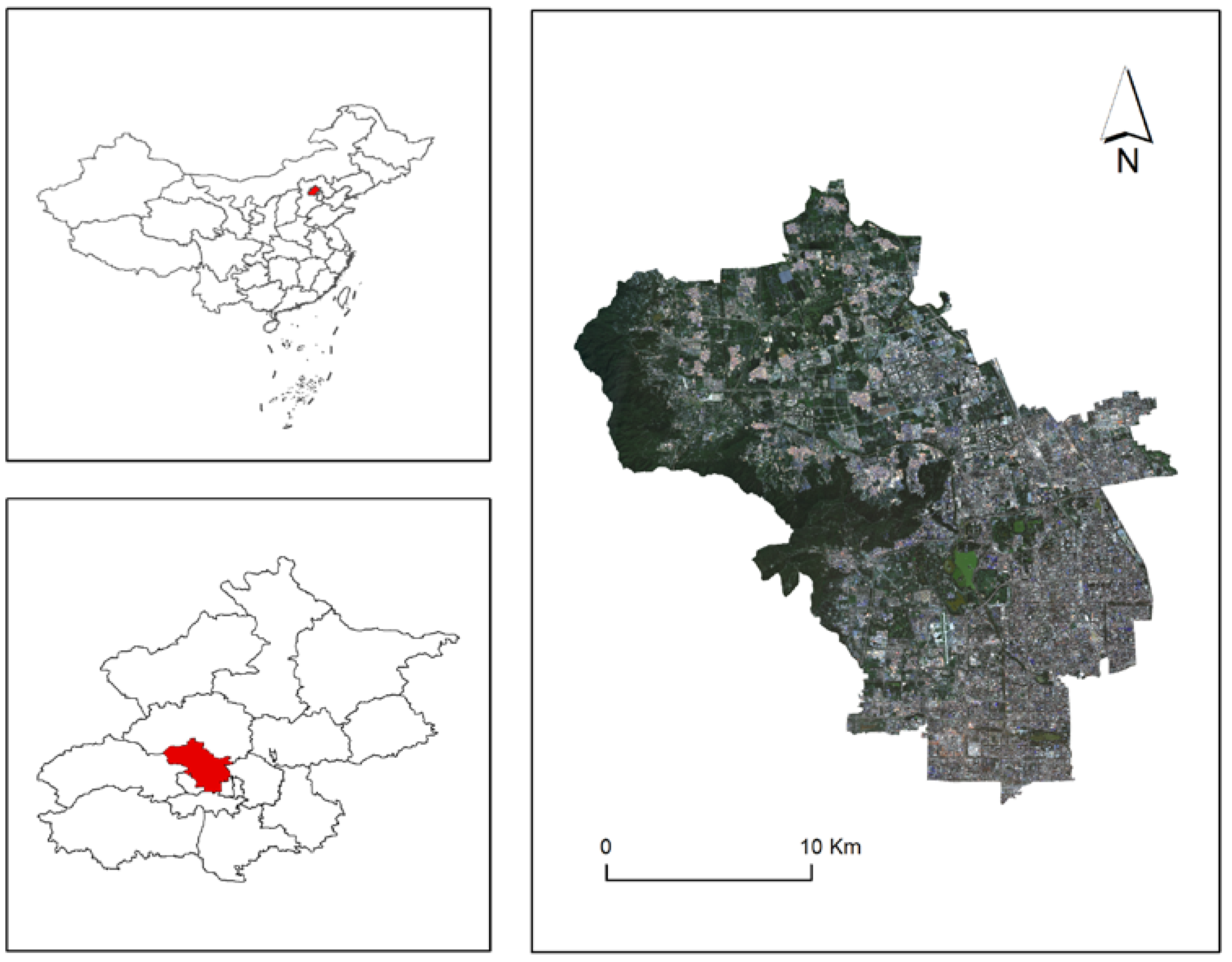
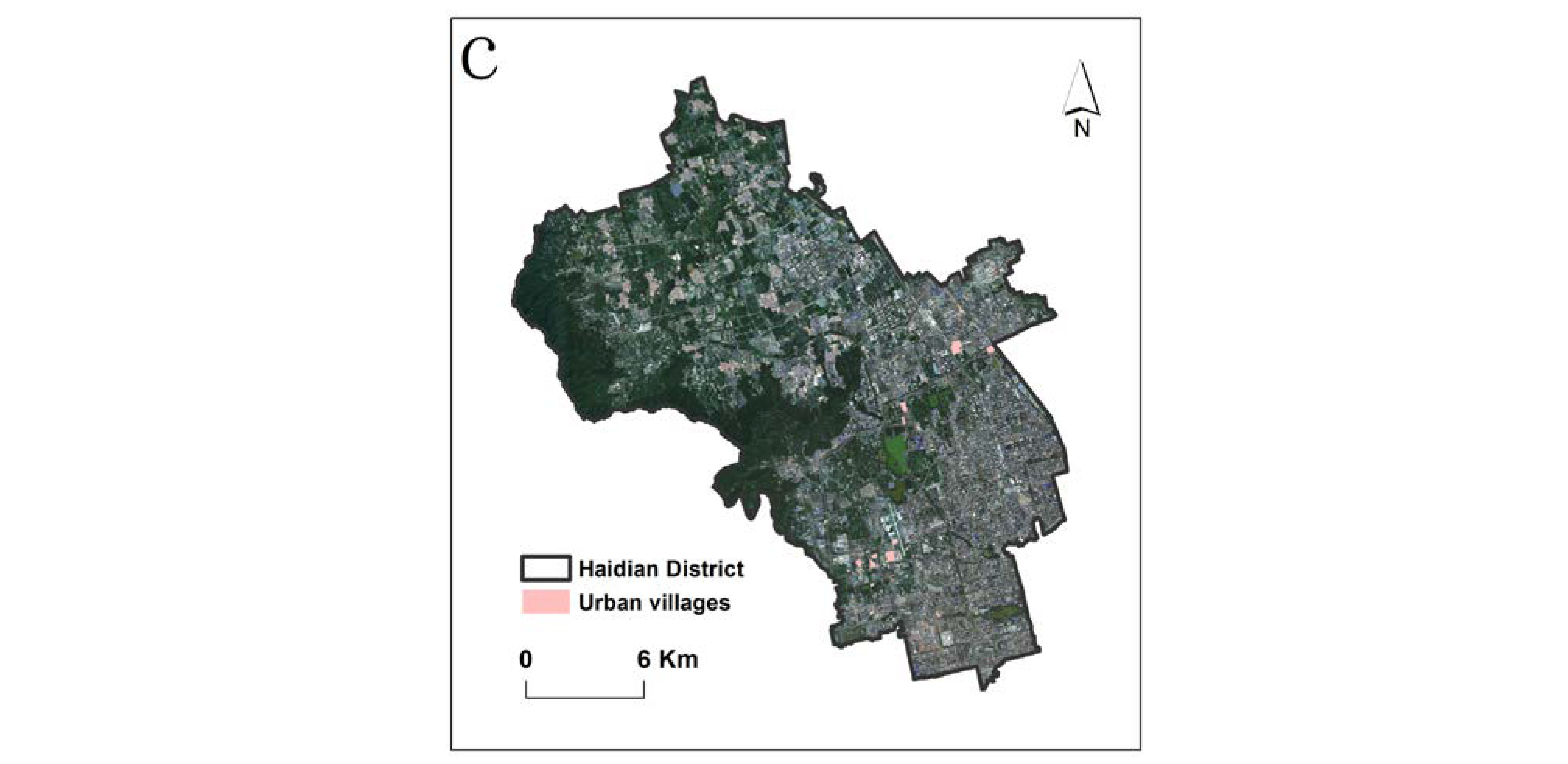
2.1. Study Area
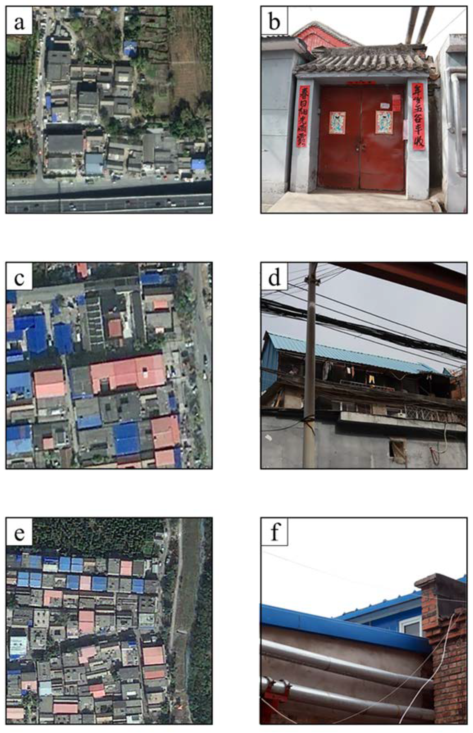
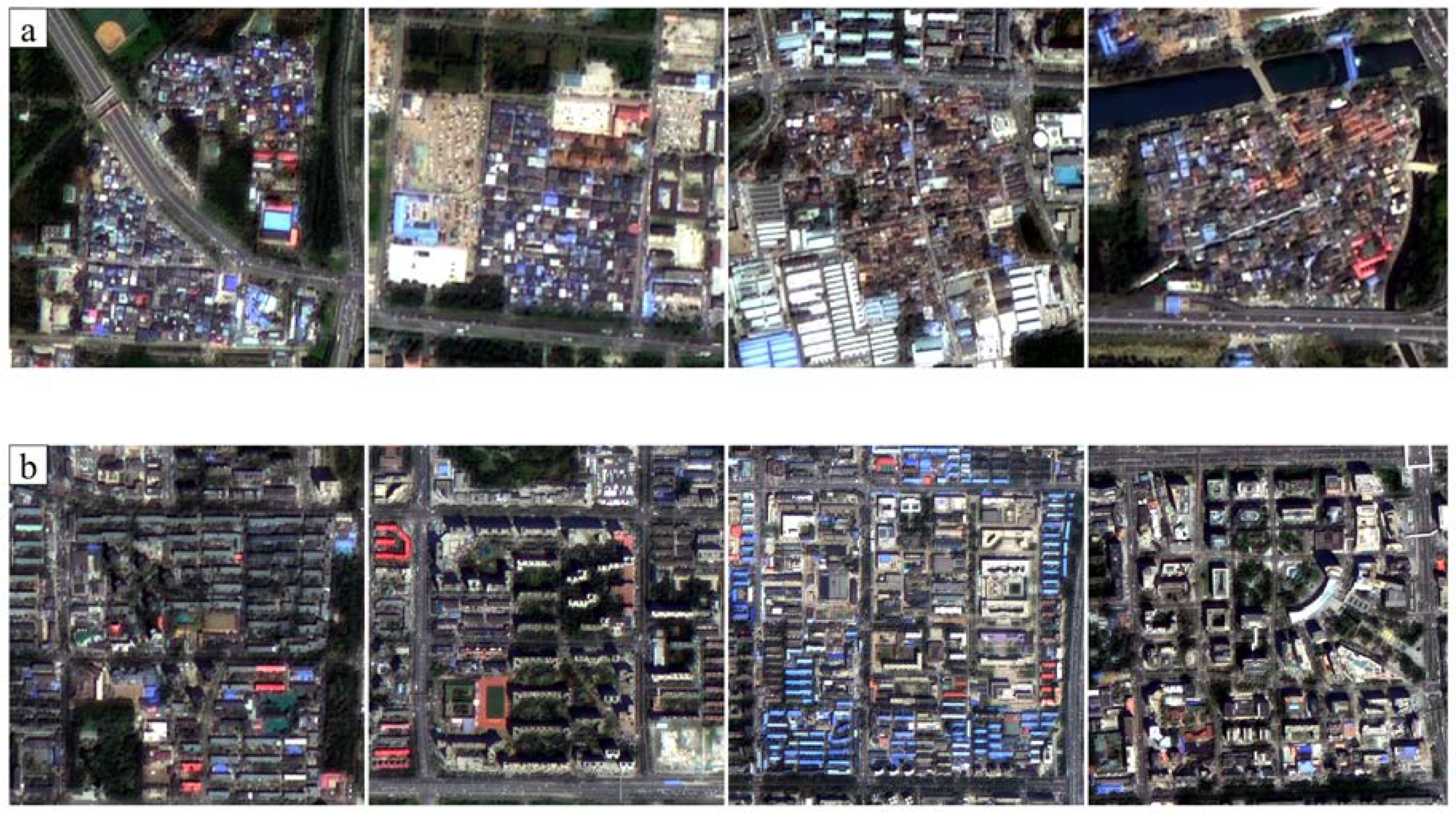
2.2. Study Object
2.3. Datasets
2.3.1. GF-1 Satellite’s High-Resolution Remote Sensing Images
2.3.2. Open Street Map (OSM)
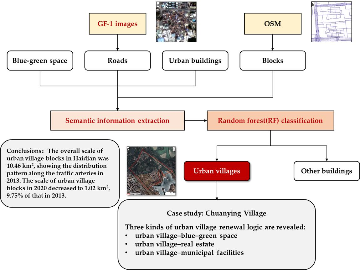
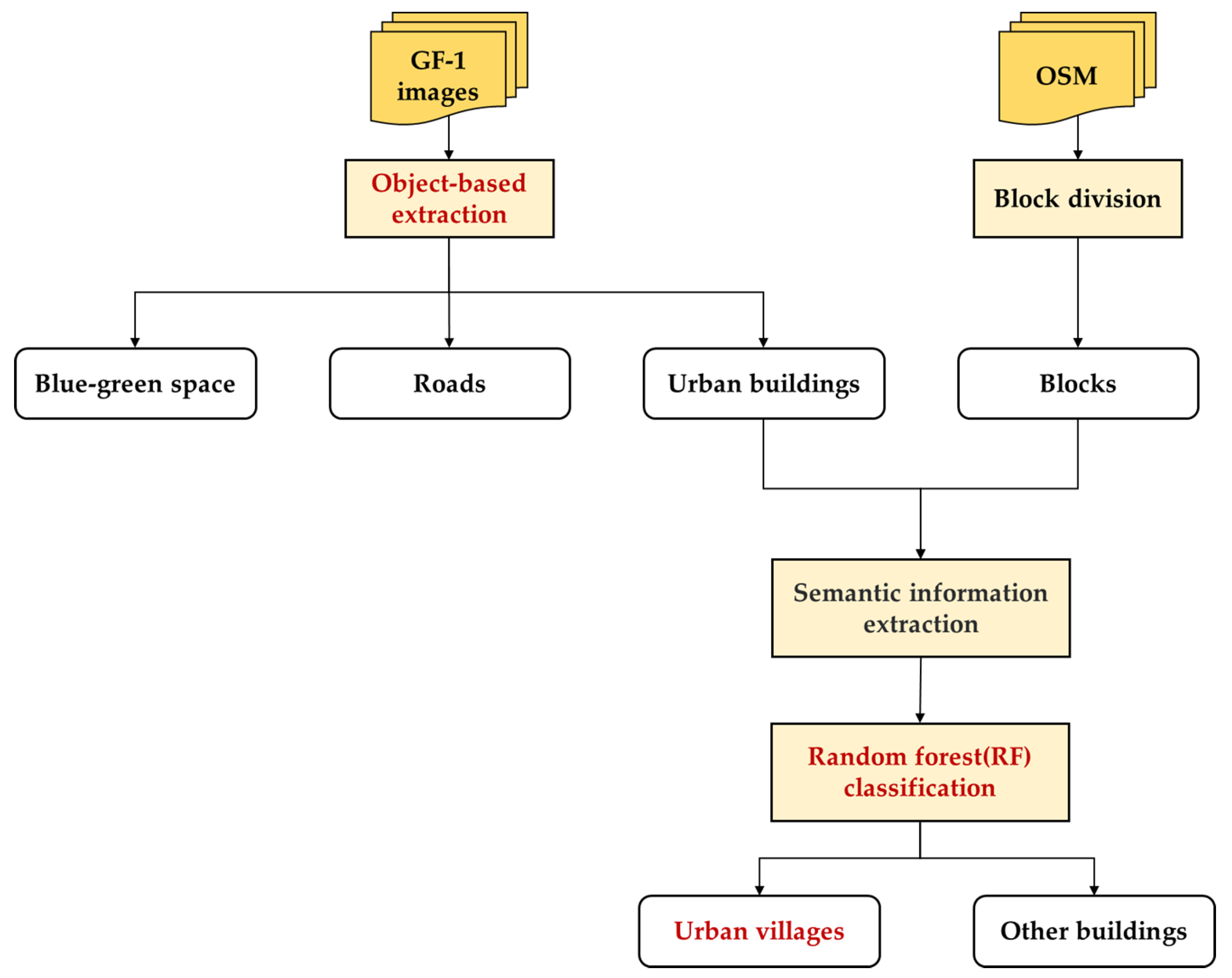
3. Method
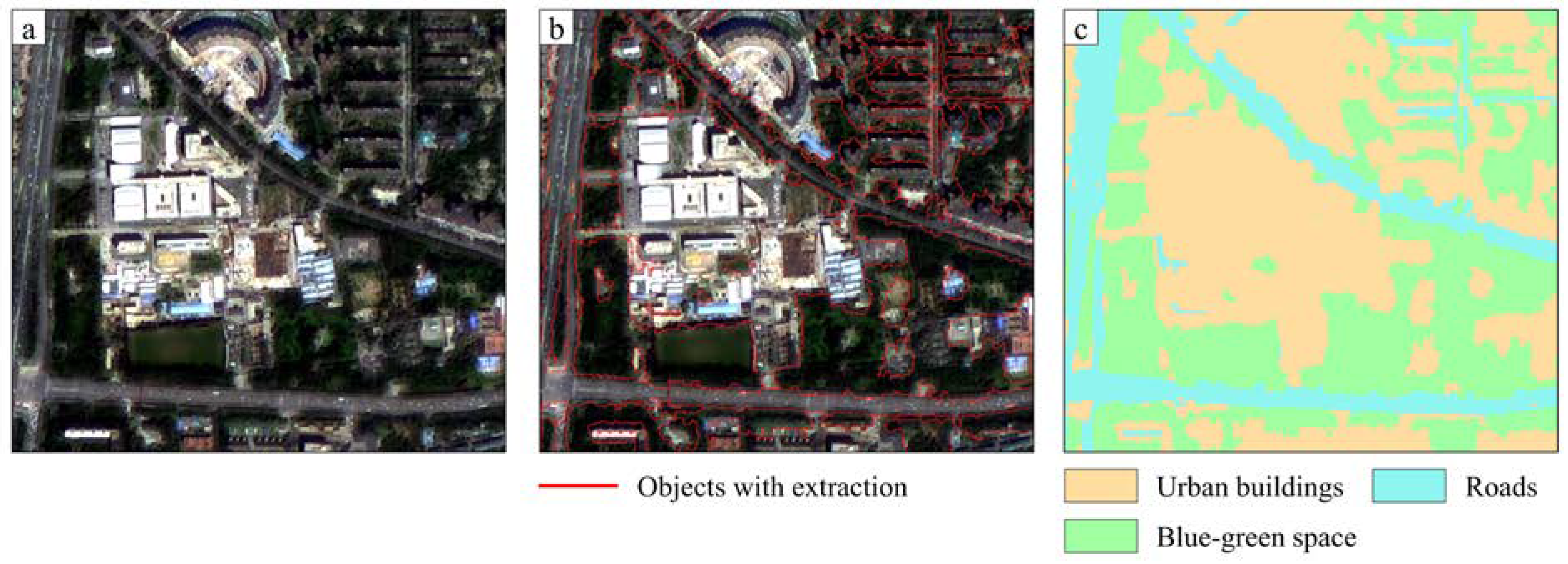
3.1. Scene Segmentation
3.2. Building Information Extraction
3.3. Scene-Based Urban Village Recognition
- Randomly sample the training set m times to obtain a sample set D with sample size m.
- Randomly select k attribute features among all attribute features and select the best segmented attribute features as nodes to construct the decision tree.
- Repeat the above two steps T times, i.e., T decision trees are built.
- These T decision trees form an RF and decide which category the data finally belongs to by voting.
3.4. Accuracy Verification
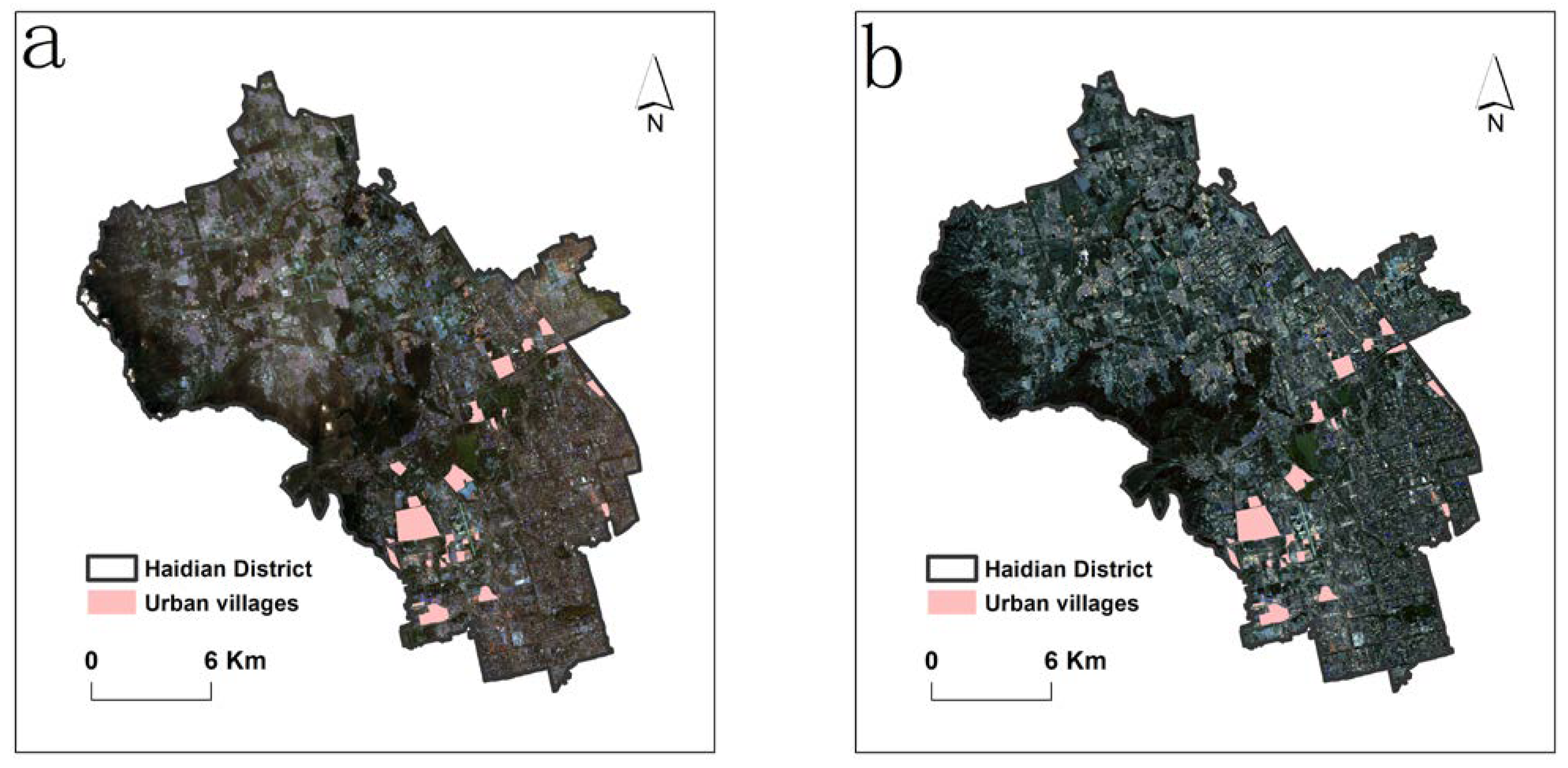
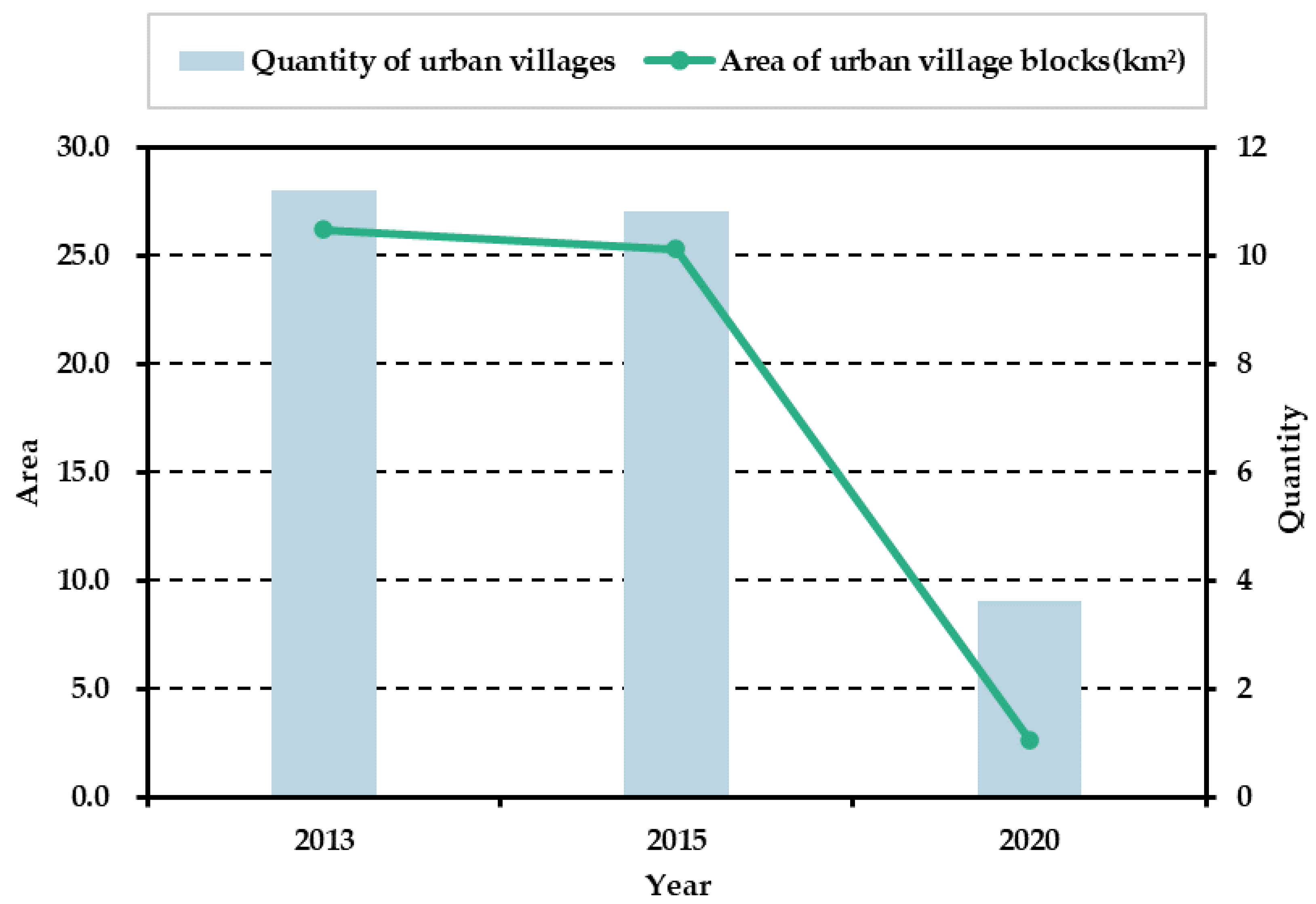
4. Spatiotemporal Distribution
4.1. Spatial Distribution
4.2. Quantitative Analysis
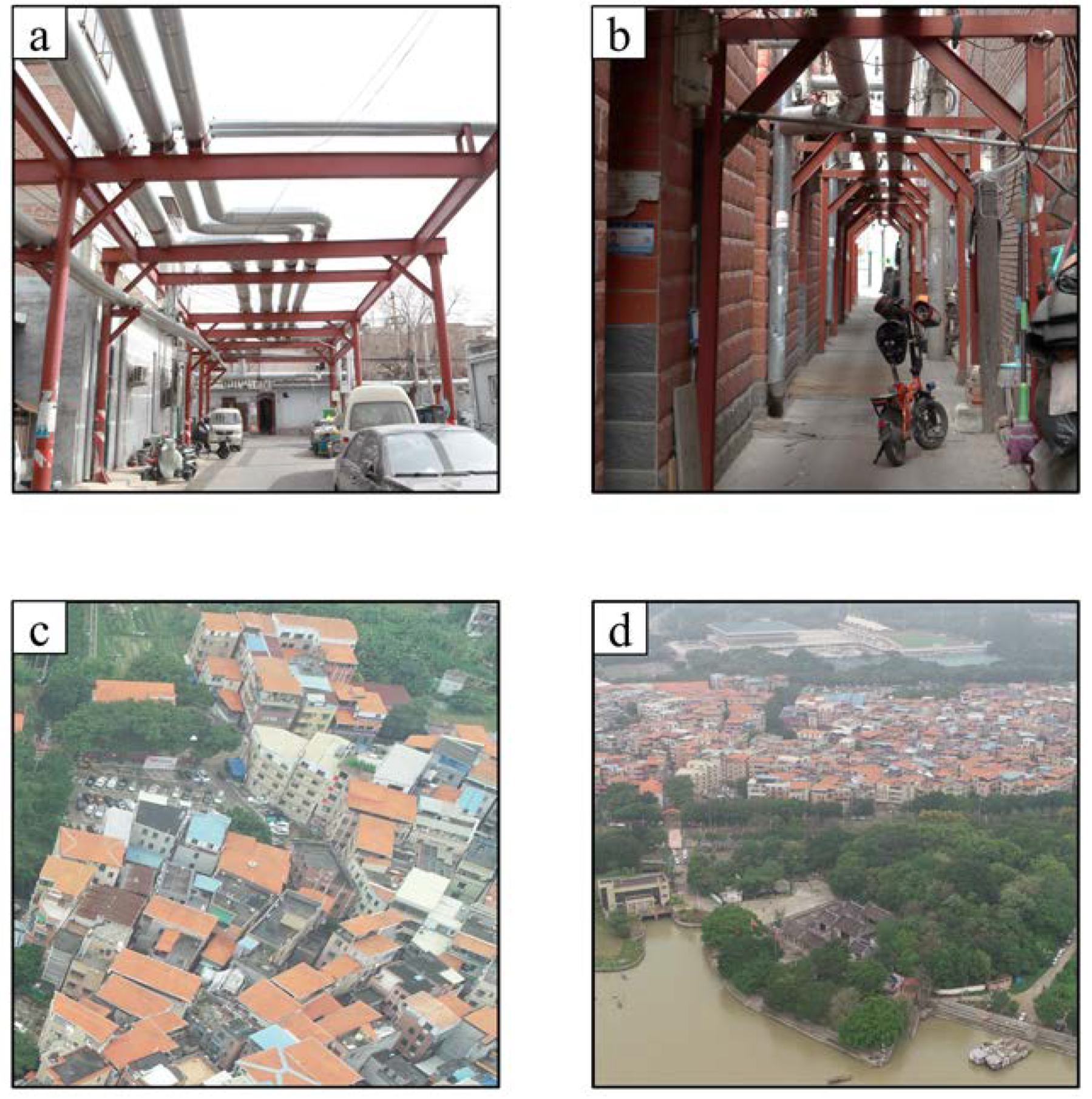
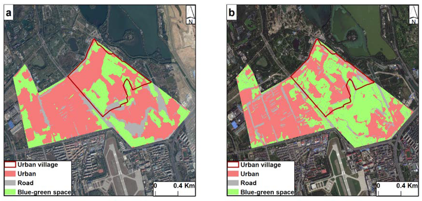
5. Case Study of Chuanying Village
5.1. Resident Health Orientation: Transformation of Urban Villages into Blue–Green Spaces
5.2. Local Financial Orientation: Transformation of Urban Villages into Real Estate
5.3. Public Service Orientation: Transformation of Urban Villages into Municipal Facilities
6. Conclusions
- 1.
- In terms of identification methods, a scene-based recognition method was used to identify urban villages in Haidian District based on the remote sensing data of GF-1 satellite. This method uses the high-level semantic information of urban villages to identify urban village areas by extracting, counting, and analyzing the overall features of buildings within the blocks. However, using the scene-based identification method for urban village identification has certain flaws. First, the suitability of the scene, namely, the correct division of the blocks, is extremely important for the method. Second, certain tiny urban villages are not correctly identified during the recognition process, mainly because of the weak influence of small urban village buildings on the overall features of the whole block. Thus, the overall features of the block still tend to be urban buildings. Therefore, the fine delineation of scenes must be focused on in future research. Given the limited capability of optical images in urban mapping, multidimensional identification of urban villages can also be considered in the future by combining multisource data, such as POI data and population data, including the height of buildings and the development of multifunctional buildings.In terms of scale, this paper focuses more on the trend changes and spatial and temporal patterns of urban villages as a whole. Changes within the urban village, including changes in building density and floor area ratio, will likewise affect the attributes and functions of the urban village as a migrant cluster. Such a phenomenon may not be ruled out: part of the peripheral land of an urban village is given away (perhaps farmland), but the building density and floor area ratio in its center increases. Although the area of the urban village block is reduced in this case, it has a stronger capacity to accommodate migrants and therefore a broader employment hinterland that can be radiated externally. Therefore, higher resolution remote sensing images, more accurate remote sensing interpretation techniques, block-based demographic data and related economic and social data should be used to resolve the accommodation capacity and its radiating capacity of internal urban villages as migrant clusters.
- 2.
- In terms of the transferability of the research, the scene-based approach has great potential for complex urban structure detection, particularly in modeling and portraying complex scenarios, which also play an active role in transferability studies. Due to Beijing’s capital function and Beijing’s high level of urbanization, Haidian District exhibits a relatively ideal state of urban village regeneration—only a decrease in urban villages without the emergence of new urban villages either in terms of area or location. The emergence of new urban villages will obviously present a more complex land use flow and a more integrated urban village renewal pattern in the study of the overall urban system. As urbanization in China is still growing at a high rate, new periurban villages may gradually become urban villages as the urban fringe sprawls. Therefore, the question answered in this study, i.e., “What has become of the disappearing urban villages?” can be extended to “How do new urban villages emerge and how do they transform?” in further research. The type of research can be expanded from mature megacities to medium and large cities undergoing rapid urbanization. The scope of research will be expanded from Beijing to other research regions worldwide to provide experiences and insights on informal settlements and the development of urban sprawl in Africa and Latin America.
- 3.
- In terms of policy revelation, given the advent of urban renewal in urban planning practice, a single flow of land to real estate is no longer feasible in terms of local finance and urban ecology. An integrated, multieffective, and systematic approach to renewal that combines financial gains and public services is being sought instead. Urban green parks have become an important flow of land in urban villages in urban regeneration because of the positive role of blue–green space in improving the health of residents, the quality of life of citizens, and the urban environment and climate regulation of cities. These parks also contribute to the green and low-carbon sustainable development of cities. On the other hand, given the detailed analysis of urban village land flows in this study, local governments are already realizing different and differentiated urban functions through multiple urban village urban renewal land flows in practice. We are committed to introducing a product portfolio for urban renewal in urban villages that balances the fiscal budget and residents’ wellbeing in future research. In particular, we are devoted to establishing an urban renewal model for urban villages with the view of maintaining a balance between fiscal budget and residents’ wellbeing by measuring the revenue and cost of real estate, the value and cost of landscape and ecology brought by the construction of green parks, and the value and cost of public services brought by large-scale municipal projects. Moreover, the externalities, such as the impact of land prices in the surrounding areas before and after the transformation and the revenue brought by the accessibility of transportation roads, are considered. The model is used to simulate different shares and proportions of land flow in urban villages under various scenarios of location and economic development. It also provides guidance and reference for global urban renewal policymakers and urban planners.
Author Contributions
Funding
Data Availability Statement
Conflicts of Interest
References
- Schmidt-Traub, G.; Kroll, C.; Teksoz, K.; Durand-Delacre, D.; Sachs, J.D. National baselines for the Sustainable Development Goals assessed in the SDG Index and Dashboards. Nat. Geosci. 2017, 10, 547–555. [Google Scholar] [CrossRef] [Green Version]
- Sverdlik, A. Ill-health and poverty: A literature review on health in informal settlements. Environ. Urban 2011, 23, 123–155. [Google Scholar] [CrossRef]
- Liu, Y.; He, S.; Wu, F.; Chris, W. Urban villages under China’s rapid urbanization: Unregulated assets and transitional neighbourhoods. Habitat Int. 2010, 34, 135–144. [Google Scholar] [CrossRef]
- Qi, W.; Liu, S.; Gao, X.; Zhao, M. Modeling the spatial distribution of urban population during the daytime and at night based on land use: A case study in Beijing. China J. Geogr. Sci. 2015, 25, 756–768. [Google Scholar] [CrossRef]
- Fang, C.; Zhou, C.; Gu, C.; Chen, L.; Li, S. A proposal for the theoretical analysis of the interactive coupled effects between urbanization and the eco-environment in mega-urban agglomerations. J. Geogr. Sci. 2017, 27, 1431–1449. [Google Scholar] [CrossRef]
- Liu, R.; Wong, T. Urban village redevelopment in Beijing: The state-dominated formalization of informal housing. Cities 2018, 72, 160–172. [Google Scholar] [CrossRef]
- Wu, X.; Treiman, D.J. The household registration system and social stratification in China: 1955–1996. Demography 2004, 41, 363–384. [Google Scholar] [CrossRef] [PubMed] [Green Version]
- Deng, Y.; Qi, W.; Fu, B.; Wang, K. Geographical transformations of urban sprawl: Exploring the spatial heterogeneity across cities in China 1992–2015. Cities 2020, 105, 102415. [Google Scholar] [CrossRef]
- Li, Z.; Wu, F. Residential Satisfaction in China’s Informal Settlements: A Case Study of Beijing, Shanghai, and Guangzhou. Urban Geogr. 2013, 34, 923–949. [Google Scholar] [CrossRef] [Green Version]
- Van Oostrum, M. Access, density and mix of informal settlement: Comparing urban villages in China and India. Cities 2021, 117, 103334. [Google Scholar] [CrossRef]
- Gurran, N.; Pill, M.; Maalsen, S. Hidden homes? Uncovering Sydney’s informal housing market. Urban Stud. 2021, 58, 1712–1731. [Google Scholar] [CrossRef]
- Zheng, S.; Long, F.; Fan, C.C.; Gu, Y. Urban Villages in China: A 2008 Survey of Migrant Settlements in Beijing. Eurasian Geogr. Econ. 2009, 50, 425–446. [Google Scholar] [CrossRef] [Green Version]
- Hussain, T.; Abbas, J.; Wei, Z.; Ahmad, S.; Bi, X.; Zhu, G. Impact of Urban Village Disamenity on Neighboring Residential Properties: Empirical Evidence from Nanjing through Hedonic Pricing Model Appraisal. J. Urban Plan. Dev. 2021, 147, 04020055. [Google Scholar] [CrossRef]
- Wang, Y.; Wang, Y.; Wu, J. Urbanization and Informal Development in China: Urban Villages in Shenzhen. Int. J. Urban Reg. Res. 2009, 33, 957–973. [Google Scholar] [CrossRef]
- Wu, F.; Zhang, F.; Webster, C. Informality and the Development and Demolition of Urban Villages in the Chinese Peri-urban Area. Urban Stud. 2013, 50, 1919–1934. [Google Scholar] [CrossRef]
- Li, L.; Lin, J.; Li, X.; Wu, F. Redevelopment of urban village in China—A step towards an effective urban policy? A case study of Liede village in Guangzhou. Habitat Int. 2014, 43, 299–308. [Google Scholar] [CrossRef]
- Lai, Y.; Peng, Y.; Li, B.; Lin, Y. Industrial land development in urban villages in China: A property rights perspective. Habitat Int. 2014, 41, 185–194. [Google Scholar] [CrossRef] [Green Version]
- Deng, Y.; Chen, R.; Yang, J.; Li, Y.; Jiang, H.; Liao, W.; Sun, M. Identify urban building functions with multisource data: A case study in Guangzhou, China. Int. J. Geogr. Inf. Sci. 2022, 36, 2060–2085. [Google Scholar] [CrossRef]
- Chen, D.; Tu, W.; Cao, R.; Zhang, Y.; He, B.; Wang, C.; Shi, T.; Li, Q. A hierarchical approach for fine-grained urban villages recognition fusing remote and social sensing data. Int. J. Appl. Earth Obs. Geoinf. 2022, 106, 102661. [Google Scholar] [CrossRef]
- Zhao, L.; Ren, H.; Cui, C.; Huang, Y. A Partition-Based Detection of Urban Villages Using High-Resolution Remote Sensing Imagery in Guangzhou, China. Remote Sens. 2020, 12, 2334. [Google Scholar] [CrossRef]
- Tewolde, M.G.; Cabral, P. Urban Sprawl Analysis and Modeling in Asmara, Eritrea. Remote Sens. 2011, 3, 2148–2165. [Google Scholar] [CrossRef] [Green Version]
- Liu, X.; Liang, X.; Li, X.; Xu, X.; Ou, J.; Chen, Y.; Li, S.; Wang, S.; Pei, F. A future land use simulation model (FLUS) for simulating multiple land use scenarios by coupling human and natural effects. Landsc. Urban Plan. 2017, 168, 94–166. [Google Scholar] [CrossRef]
- Guan, Q.; Yang, L.; Pan, N.; Lin, J.; Xu, C.; Wang, F.; Liu, Z. Greening and Browning of the Hexi Corridor in Northwest China: Spatial Patterns and Responses to Climatic Variability and Anthropogenic Drivers. Remote Sens. 2018, 10, 1270. [Google Scholar] [CrossRef] [Green Version]
- Tobler, W. On the First Law of Geography: A Reply. Assoc. Am. Geogr. 2004, 94, 304–310. [Google Scholar] [CrossRef]
- Niu, N.; Jin, H. Integrating multiple data to identify building functions in China’s urban villages. Environ. Plan B Urban Anal. City Sci. 2021, 48, 1527–1542. [Google Scholar] [CrossRef]
- Zhu, Y.; Geiss, C.; So, E.; Jin, Y. Multitemporal Relearning With Convolutional LSTM Models for Land Use Classification. IEEE J. Sel. Top Appl. Earth Obs. Remote Sens. 2021, 14, 3251–3265. [Google Scholar] [CrossRef]
- Liu, H.; Wu, C. Developing a Scene-Based Triangulated Irregular Network (TIN) Technique for Individual Tree Crown Reconstruction with LiDAR Data. Forests 2020, 11, 28. [Google Scholar] [CrossRef] [Green Version]
- Gao, Y.; Shahab, S.; Ahmadpoor, N. Morphology of Urban Villages in China: A Case Study of Dayuan Village in Guangzhou. Urban Sci. 2020, 4, 23. [Google Scholar] [CrossRef]
- Weiss, M.; Jacob, F.; Duveiller, G. Remote sensing for agricultural applications: A meta-review. Remote Sens. Environ. 2020, 236, 111402. [Google Scholar] [CrossRef]
- Schneider, A.; Friedl, M.A.; Potere, D. Mapping global urban areas using MODIS 500-m data: New methods and datasets based on ‘urban ecoregions’. Remote Sens. Environ. 2010, 114, 1733–1746. [Google Scholar] [CrossRef]
- Ma, L.; Li, M.; Ma, X.; Cheng, L.; Du, P.; Liu, Y. A review of supervised object-based land-cover image classification. ISPRS J. Photogramm. Remote Sens. 2017, 130, 277–293. [Google Scholar] [CrossRef]
- Rodriguez-Galiano, V.F.; Ghimire, B.; Rogan, J.; Chica-Olmo, M.; Rigol-Sanchez, J.P. An assessment of the effectiveness of a random forest classifier for land-cover classification. ISPRS J. Photogramm. Remote Sens. 2012, 67, 93–104. [Google Scholar] [CrossRef]
- Hao, P.; Geertman, S.; Hooimeijer, P.; Sliuzas, R. The Land-Use Diversity in Urban Villages in Shenzhen. Environ. Plan A Econ. Sci. 2012, 44, 2742–2764. [Google Scholar] [CrossRef]
- Liu, Y.; Zhang, F.; Wu, F.; Liu, Y.; Li, Z. The subjective wellbeing of migrants in Guangzhou, China: The impacts of the social and physical environment. Cities 2017, 60, 333–342. [Google Scholar] [CrossRef]
- Zhu, Q.; Xu, X.; Sun, Z.; Liang, D.; An, X.; Chen, L.; Yang, G.; Huang, L.; Xu, S.; Yang, M. Estimation of Winter Wheat Residue Coverage Based on GF-1 Imagery and Machine Learning Algorithm. Agronomy 2022, 12, 1051. [Google Scholar] [CrossRef]
- Calka, B.; Moscicka, A. Usefulness of OSM and BDOT10k Data for Developing Tactile Maps of Historic Parks. Appl. Sci. 2022, 12, 9731. [Google Scholar] [CrossRef]
- Weiss, D.; Nelson, A.; Gibson, H.; Temperley, W.; Peedell, S.; Lieber, A.; Hancher, M.; Poyart, E.; Belchior, S.; Fullman, N.; et al. A global map of travel time to cities to assess inequalities in accessibility in 2015. Nature 2018, 553, 333–336. [Google Scholar] [CrossRef]
- Chen, Y.; Jiang, L. Influencing Factors of Direct Carbon Emissions of Households in Urban Villages in Guangzhou, China. Int. J. Environ. Res. Public Health 2022, 19, 17054. [Google Scholar] [CrossRef]
- Huang, X.; Liu, H.; Zhang, L. Spatiotemporal Detection and Analysis of Urban Villages in Mega City Regions of China Using High-Resolution Remotely Sensed Imagery. IEEE Trans. Geosci. Remote Sens. 2014, 53, 3639–3657. [Google Scholar] [CrossRef]
- Wu, Y.; Zhang, Y.; Han, Z.; Zhang, S.; Li, X. Examining the Planning Policies of Urban Villages Guided by China’s New-Type Urbanization: A Case Study of Hangzhou City. Int. J. Environ. Res. Public Health 2022, 19, 16596. [Google Scholar] [CrossRef]
- Hao, P.; Geertman, S.; Hooimeijer, P.; Sliuzas, R. Spatial Analyses of the Urban Village Development Process in Shenzhen, China. Int. J. Geogr. Inf. Sci. 2013, 37, 2177–2197. [Google Scholar] [CrossRef]


| Confusion Matrix | True Value | ||
|---|---|---|---|
| Positive | Negative | ||
| Predicted Value | Positive | TP | FP (Type II) |
| Negative | FN (Type I) | TN | |
Disclaimer/Publisher’s Note: The statements, opinions and data contained in all publications are solely those of the individual author(s) and contributor(s) and not of MDPI and/or the editor(s). MDPI and/or the editor(s) disclaim responsibility for any injury to people or property resulting from any ideas, methods, instructions or products referred to in the content. |
© 2023 by the authors. Licensee MDPI, Basel, Switzerland. This article is an open access article distributed under the terms and conditions of the Creative Commons Attribution (CC BY) license (https://creativecommons.org/licenses/by/4.0/).
Share and Cite
Wei, H.; Cao, Y.; Qi, W. The Vanishing and Renewal Landscape of Urban Villages Using High-Resolution Remote Sensing: The Case of Haidian District in Beijing. Remote Sens. 2023, 15, 1835. https://doi.org/10.3390/rs15071835
Wei H, Cao Y, Qi W. The Vanishing and Renewal Landscape of Urban Villages Using High-Resolution Remote Sensing: The Case of Haidian District in Beijing. Remote Sensing. 2023; 15(7):1835. https://doi.org/10.3390/rs15071835
Chicago/Turabian StyleWei, Hubin, Yue Cao, and Wei Qi. 2023. "The Vanishing and Renewal Landscape of Urban Villages Using High-Resolution Remote Sensing: The Case of Haidian District in Beijing" Remote Sensing 15, no. 7: 1835. https://doi.org/10.3390/rs15071835