1. Introduction
A large number of frozen archaeological sites are under threat due to receding glacial ice and permafrost [
1]. Due to the often difficult accessibility in high altitude and high latitude regions as well as poor visibility of sites, artifacts are frequently discovered by chance rather than through systematic surveys. Once the presence of archaeological remains is established, more methodical investigations follow, leading to a clustering of known sites. However, the site distributions remain largely incomplete and many sites are destroyed before they are recorded [
2].
Global climate change has led to a rapid and continuing decline of cryogenic environments. Glaciers are receding and losing mass, and this development is accelerating [
3,
4]. Snow cover in the Northern hemisphere has decreased over the past decade while ice mass loss of the Greenland and Antarctic ice sheet has increased [
5] (p. 42). Glaciers are predicted to lose substantial amounts of volume, decreasing 15–55% (RCP 2.6) to 35–85% (RCP 8.5) by 2100 [
3] (p. 62). Many of the smaller archaeologically important ice patches will melt much earlier. Archaeologically relevant near surface permafrost will recede between 37% (RCP 2.6) and 81% (RCP 8.5) by 2100 [
5] (p. 62).
While finds from frozen archaeological contexts have been recovered for more than a century, their importance for understanding past human use of cryogenic environments such as high alpine or high latitude regions only became clear much later. In the 1960s the Norwegian O. Farbregd [
6] (p. 9) coined the term glacial archaeology (glasial arkeologi), but the published finds from frozen contexts in Norway only reached a broader international audience in the 1990s [
7]. The exploration of archaeological sites in high altitude cryogenic environments in central Europe was boosted by the discovery of Ötzi “the Iceman” in the Alps in 1991 [
8]. Glacial archaeology in North America became a research topic in 1997 when dung-rich ice patches in the Yukon revealed archaeozoological finds as well as artifacts spanning a range of 8000 years [
9]. Frozen human remains were also found in North America in 1999 when the Kwäday Dän Ts’inchi was recovered with an assemblage of well-preserved archaeological materials [
10]. The spectacular organic preservation in cryogenic environments sparked the interest of archaeologists worldwide and led to a recognition of the potential frozen contexts have for our understanding of the prehistoric use of mountain and arctic environments as well as for reconstructing the paleoecology and economies in a prehistoric setting [
8,
9,
10,
11,
12,
13]. The creation of the Journal of Glacial Archaeology in 2014 gave the niche field a platform for debate and publication of results.
Central Norway and the southern reaches of the country have yielded a substantial archive of glacial archaeological information in the past years. In Innlandet County, more than 3500 finds have been collected through continuous work over the past 15 years [
14]. The finds’ dates range from 4000 BCE to modern times and encompass mostly organic artifacts which are rarely preserved at all in other archaeological contexts, much less in such pristine condition. In most cases, artifacts and sites in the area are related to hunting activities, in particular reindeer hunting [
15,
16]. However, select sites, such as the Lendbreen ice patch, formed through travel routes in the mountains. Other than the usual hunting sites, these locations yield transportation-related finds, clothing, and other items of everyday use [
17,
18].
The north of the country remains relatively unexplored with regards to glacial archaeology. While occasional chance finds are made, northern Norway so far lacks consistent efforts in surveys of ice patches, and thus, little is known about the state of glacial archaeological sites. Here we present the preliminary results of a remote sensing and on-ground survey in 2021 and 2022 on the arctic island of Seiland and elaborate upon the usage of remote sensing data and GIS analysis for glacial archaeology surveys.
2. The Study Area
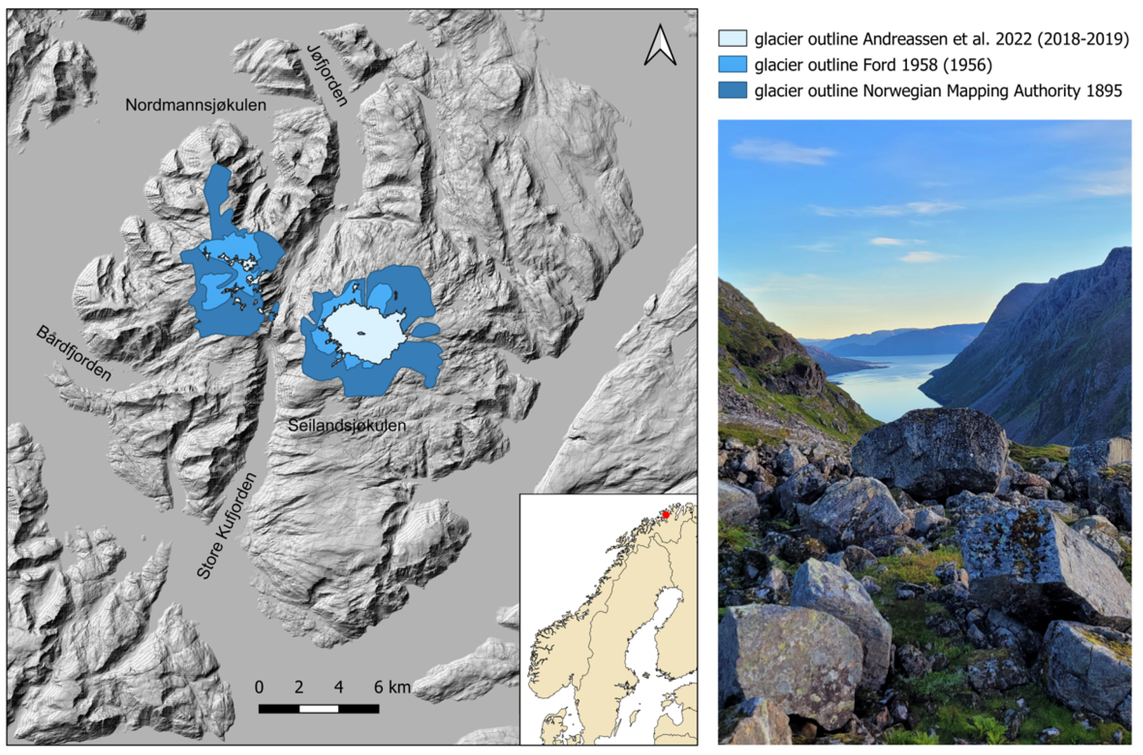
Seiland is one of the largest islands in mainland Norway (
Figure 1). Lying in Finnmark (Norway’s largest county), Seiland has an area of 583.65 km
2 and is divided in half by the two municipalities Alta and Hammerfest. It lies in a system of fjords and wide sounds, sheltered from the volatile Norwegian Sea in the west behind the larger Sørøya island. Topographically, it consists of a thin strip of rugged but seasonally arable land along parts of the coastline which then quickly rises hundreds of metres from the sea to a high plateau situated at ca. 600–1000 m above sea level. Seiland peaks at 1078 m a.s.l. at Seilandstuva, surrounded by Nordmannsjøkelen. Along many parts of the coastline, the mountains fall steeply into the sea. Several long fjords and large bays cut inland. Store Kufjorden in the south and Jøfjorden coming from the north divide the island into two halves, separated by the pass Riehppi (Sami)/Straumskaret (Norwegian) and a valley with a total length from sea to sea of just 6 km. On either side of the pass, the plateau has historically had two glaciers—the larger Seilandsjøkulen on the east side and the smaller and patchier Nordmannsjøkulen to the west, in addition to numerous local ice patches. Historical maps and older orthophotos show that the glaciers have shrunk significantly in the past 100 years (
Figure 1), and may well have been connected during the Little Ice Age (ca. 1500–1800 CE). The Nordmannsjøkulen on the western half of the island and Seilandsjøkulen on the eastern half have both shrunk since the late 1800s. Nordmannsjøkulen has almost completely disappeared. How dramatic the melt has been over the past decades is illustrated by a description from Jacobsen in 1983 [
19] (p. 507): “Nordmannsbreen [glacier] is 28,818 km
2 in total size […]. The glacier is 9 km long in the north–south direction and 5 km wide. The icecap is completely covered in snow most of the year. During particularly warm summers the top snow ablates, uncovering the blue-tinted ice sheet […]. However, this only takes place one or two times over a 20 year period.” The 1895 topographic map shows large stretches of the plateau covered in ice (
Figure 1). A first dedicated documentation was created in the 1950s by D. C. Ford [
20] finding that Seilandsjøkulen had diminished by 56% since 1895 and that the remaining bodies of ice of Nordmannsjøkulen “appear to be residual and very thin” [
20]. Since then, the melt has continued and Nordmannsjøkulen is largely gone, while Seilandsjøkulen continues to lose mass.
3. Historical Background and Previous Archaeological Research
Based on the inventory of archaeological sites of the Troms and Finnmark County Authority Section for Cultural Heritage, Seiland’s known archaeological sites are virtually all situated along the coast line. The shores of Seiland have been subject to human activity for at least 9000 years, and the oldest archaeological remains are represented by open air sites in the northern part of the island over 30 m a.s.l. [
22], one of which was unknown until we incidentally identified it during the survey. The date is currently not confirmed by a radiocarbon date, but lithics indicate that this is a likely time for the site’s emergence. We hypothesized that the site distribution on Seiland is possibly more reflective of modern accessibility and survey activity rather than prehistoric economic usage. While fisheries in the waters surrounding Seiland are rich and likely were a primary food source in prehistory, it is unlikely that the high plateau did not see any economic usage. Rare chance finds from the plateau indicate at least some level of hunting activity [
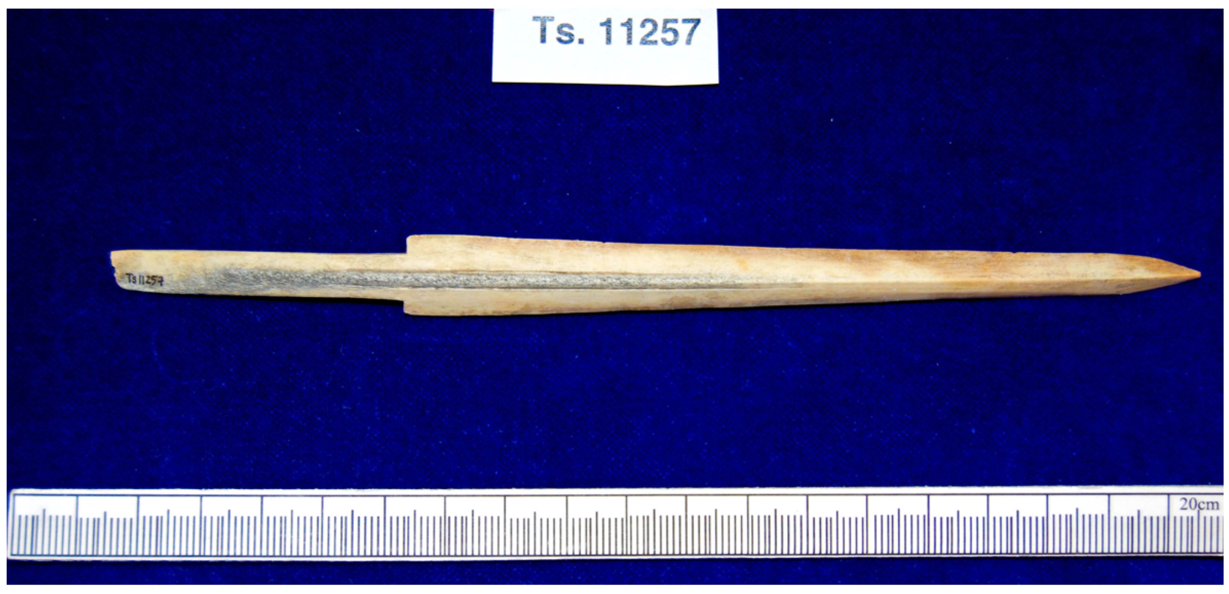
23]. In the 1990s and 2000s, two stray finds were chanced upon by reindeer herders. No archaeological structures have ever been found on the plateau. The only finds from the interior are one antler arrowhead (
Figure 2) and one iron arrowhead with organic remains still partly intact. Both of these stem from areas which suggest they may have melted out from local ice patches [
23].
Historically, the reindeer herding Sami population of Finnmark has used the island as a summer pasture for their flocks. This is still true today, and the island is divided into two administrative pasture zones belonging to the
siida (i.e., cooperative Sami family groups) Seiland west and east. According to Vorren [
24], who carried out an extensive investigation into reindeer-herding Sami migratory patterns in the period 1953–57, there were three Sami
siida groups using Seiland as summer pasture for their reindeer herds, consisting of twelve families. Two of these
siida still pasture herds in the southern part of the island, while the third group uses the northeastern peninsula. All of them have winter pastures in the Kautokeino-Karasjok region and migrate seasonally between the interior and the coast [
24].
Although the Sami population in historical times have been generally divided into mobile reindeer-herding Sami and more sedentary Sami groups, this seems to be of a late Medieval to early post-Medieval origin. Before the emergence of large-scale reindeer herding, groups in the interior subsisted on hunting, fishing and foraging, following the seasons, while the coastal Sami carried on living in farmsteads or hamlets, subsisting on fishing, foraging, hunting and agropastoral practices with livestock such as sheep/goats and cattle. However, at least since the Late Iron Age, Sami groups have held small groups of reindeer within their households for transport use and as decoys during wild reindeer hunting [
25,
26].
The sounds, fjords and banks of Finnmark have historically been known to support fairly large settlements in prehistoric times [
27]. The Norwegian state has controlled the coast and taxation of the region at least since the Middle Ages (ca. 1000–1400) [
28]. Norse settlements are known to have existed as far north as the border between Troms and Finnmark, with scattered finds from peripheral Norse settlements in western Finnmark [
29]. This suggests that Seiland may lie in a liminal zone between Sami and Norse populations of the Iron and Middle Ages. Northern Troms and Finnmark are the only regions of Norway where remains of Stone Age structures still can be found in the landscape, due to relatively low developmental and agricultural pressure on the region in modern times. Structures from later periods such as the Sami Iron Age (c. 1–1000 CE) and the Middle Ages include turf houses and marine mammal processing pits. Later still, the archaeological record is dominated by Norwegian and Sami fishing hamlets and farmsteads from the early modern period (c. 1400–1800 CE) (cf [
29]). Finally, Basque and Dutch whalers are known to have been operating in the fjord systems from the late 1500s to early 1700s, depleting the northern Norwegian right whale populations and leaving behind elusive archaeological structures in bays and inlets [
30]. Despite these well-attested prehistoric and historical population groups, the Seiland mountain plateau is virtually archaeologically empty.
In the past years, LiDAR data has shown that the interior of Finnmark contains tens of thousands of hunting pits in large, elaborate systems [
31]. Preliminary surveys have discovered systems of stone-built hunting blinds, all mainly for hunting wild reindeer. In addition, the mobile Sami groups have left remains such as fireplaces, tent rings, ritual sites, graves and husbandry structures throughout the landscape. Often, patterns emerging from archaeological site distributions are the result of survey activities and do not show the full picture of past human behavior. Reindeer herding is ubiquitous in Finnmark today, and there are no wild herds left in Northern Scandinavia. However, it is recognized to be a fairly recent practice, believed to have started in the early Middle Ages and not completed until the early modern period [
32]. Thus, the hunting of reindeer would have been the most common way of acquiring meat, hides and bone for subsistence and trade throughout prehistory.
For the above-mentioned reasons, we considered the Seiland plateau as a prime area to investigate upland activities in prehistory and early historic periods of arctic Norway and check for potentially archaeologically productive ice patches.
4. Survey Site Selection
In order to narrow down the area of interest, it was necessary to exclude areas of the ice where finds are unlikely to occur due to difficulties of access as well as areas that are unlikely to preserve artifacts due to the conditions in the ice. While there have been finds made in larger active glacial ice (c.f. [
13,
33]), these were rather fortuitous circumstances and the finds are often severely damaged. Constantly moving ice tends to destroy items inside it over time through grinding and pressure. It is, therefore, helpful to first identify ice with minimal dynamics where survival of artifacts is more likely. These areas can be smaller ice and snow patches but also glacier fringes which have lost so much mass that they no longer flow.
The Norwegian mapping authority provides high-resolution digital elevation models based on LiDAR data, which are ideal for such applications. The data can be accessed through
https://hoydedata.no/LaserInnsyn2/ (accessed on 30 November 2022). We decided to perform a surface analysis based on [
34] which had previously been applied for landscape archaeological analysis [
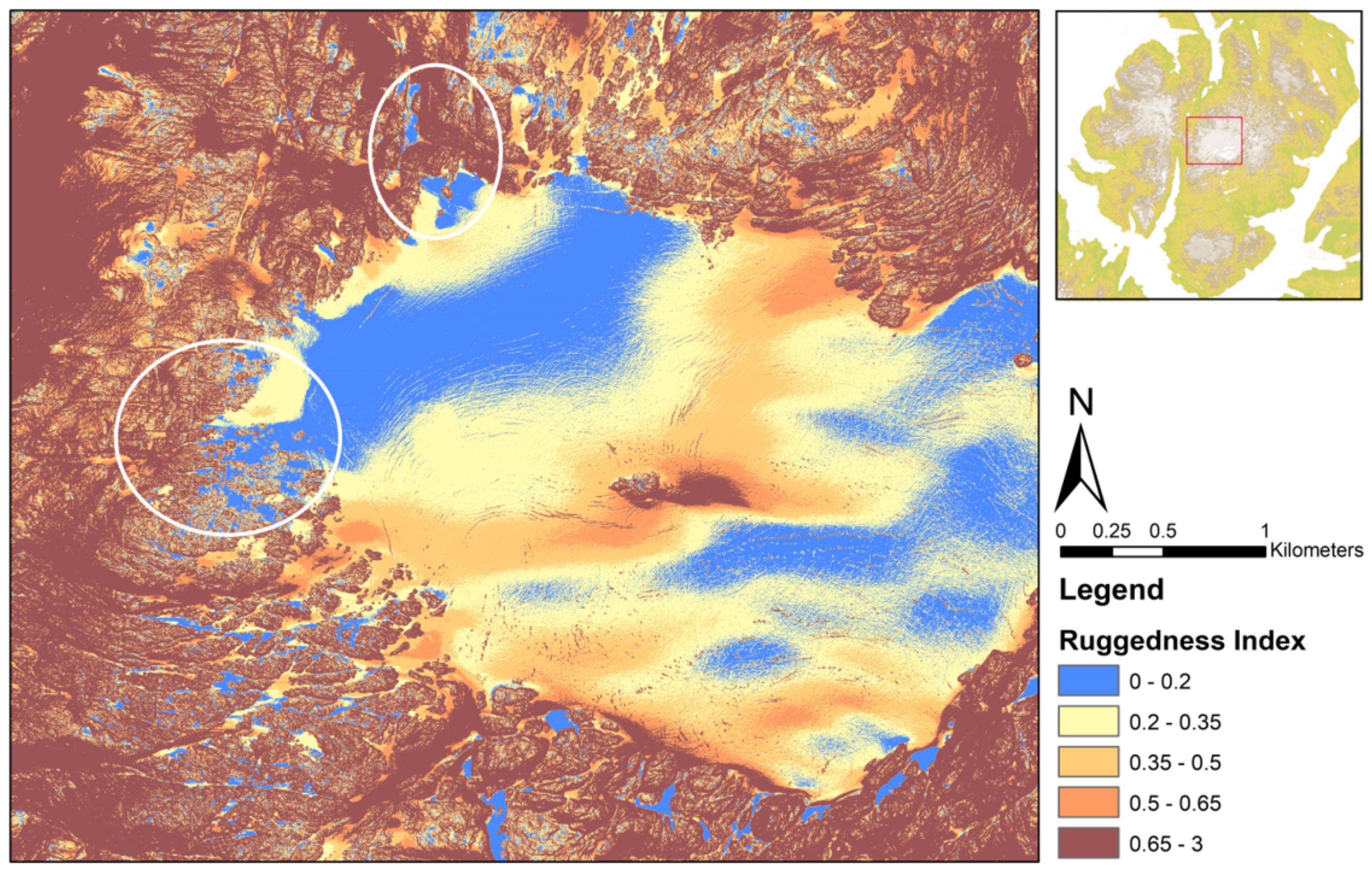
35]. This allowed us to measure topographic heterogeneity and allowed us to easily distinguish rugged ice-free terrain from glaciated surfaces (
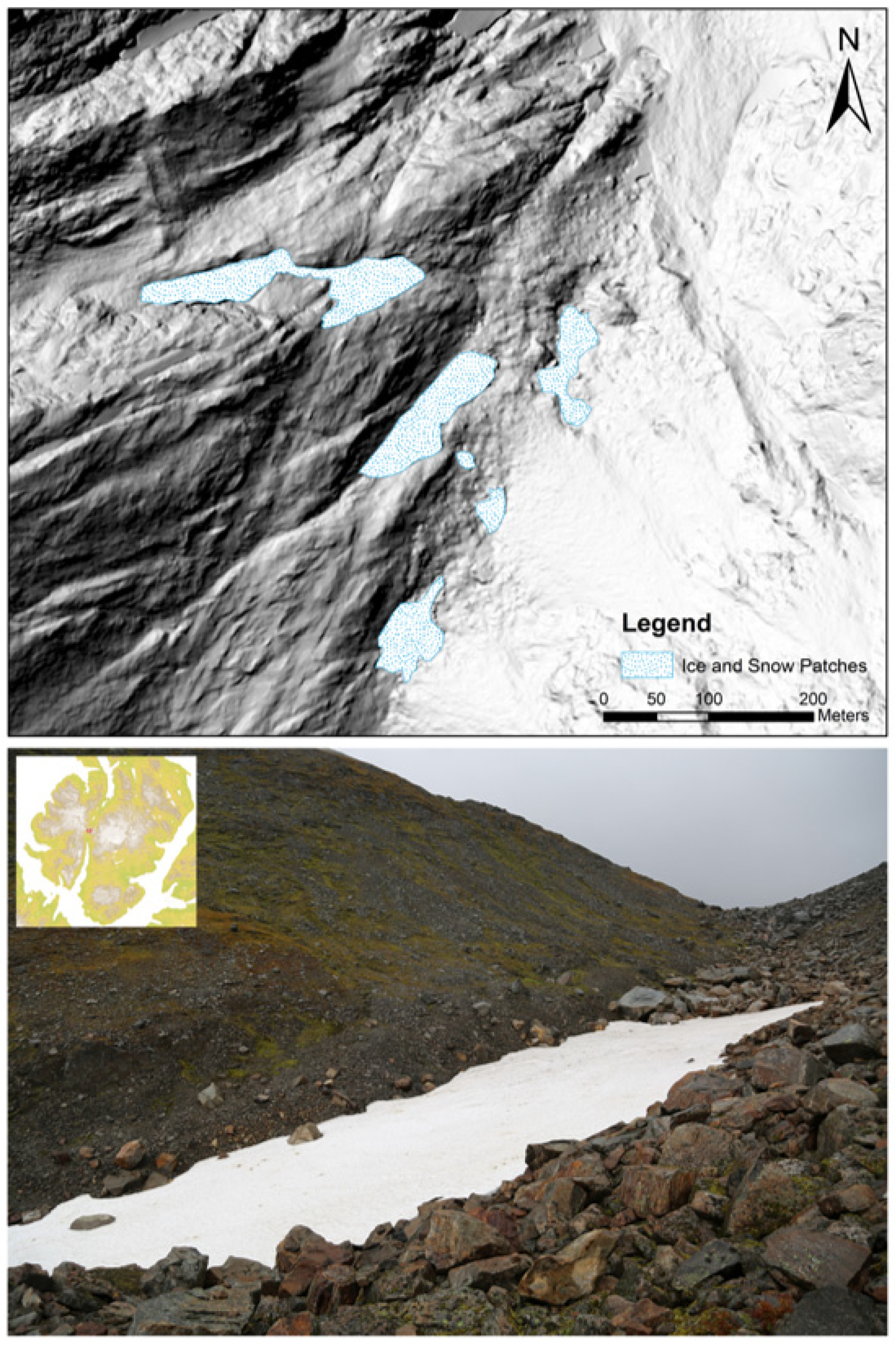
Figure 3). The topographic ruggedness index was created to highlight the relative elevation difference between neighboring cells in a digital elevation model. The index computes the difference in elevation between a central pixel and the adjacent eight pixels. Each of the eight elevation differences is then squared. All the values are summed and the square root is taken to arrive at the final result for the pixel. The index is ideal for highlighting crevasses and cracks in the ice, indicating where a lot of movement occurs and where it remains relatively stable. Of course, depending on the time of the year in which the data was acquired, snow cover on top of the glacier can even out these differences. We used LiDAR data acquired in summer and early fall during peak melt (NDH Hammerfest 2 pkt 2020). Snow cover is thus not likely to influence the analyses to a large extent. In any case, one has to pay attention and properly contextualize the results when calculating such an index. As presented in
Figure 3, there are a plethora of smaller non-moving ice patches in the western and northern part of Seilandsjøkulen.
After identifying areas with non-moving ice and snow, we used the NIR/SWIR band ratio for mapping debris-free glaciers based on Sentinel 2A datasets. Through applying a scene specific threshold, which we determined visibly, we also included slightly darker ice at the margins of glaciers and ice patches, as suggested by [
36] and different from [
37,
38] who use a general threshold of 2. We removed isolated pixels with a 3 × 3 median filter before thresholding, and then converted the mapped areas to polygons. While Pan et al. [
36] remove small ice patches in order to arrive at a more consistent dataset for larger glaciers, we omit this step. These small ice patches are often exactly what one is looking for in an archaeological context.
We then used high-resolution aerial imagery provided by the Norwegian Mapping Authority to delineate the smaller patches we wanted to visit. Of course, an index-based mapping method such as the Normalized Difference Snow/Ice Index (NDSII) [
39] would have been easy to apply, but given the availability of much higher resolution optical data, we chose to map the limited survey area through visual interpretation.
Accessibility
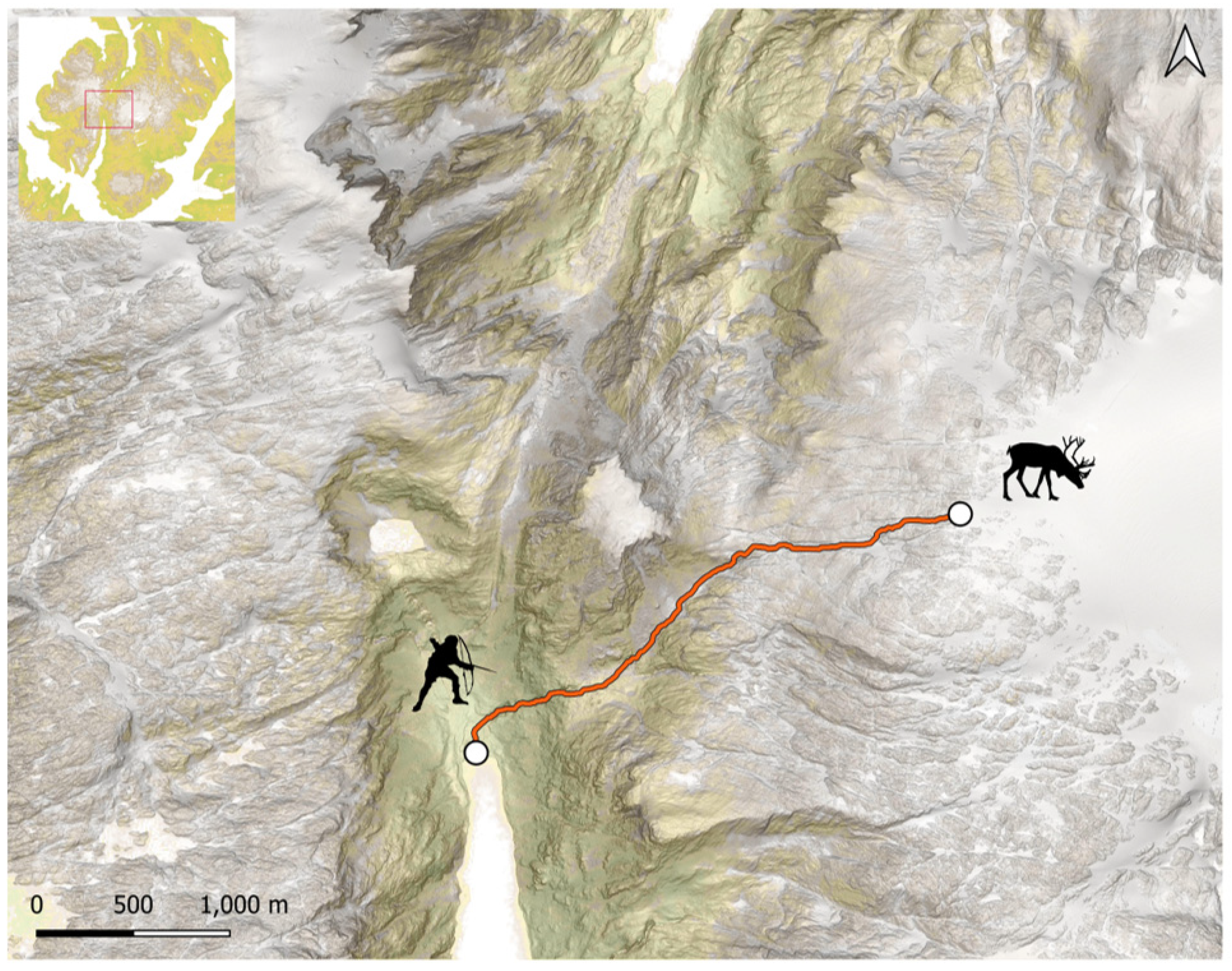
The accessibility of the plateau is a major constraint to human and animal traffic and thus correlated with the chance of discovering archaeological artifacts. Understanding the terrain is crucial for identifying areas of increased human activity. Least cost paths are an analytical tool in archaeology that has to be applied with the appropriate care and sensitivity to local variables and conditions. Especially in the Arctic, there is a strong seasonality aspect to landscape usage. The high plateau of Seiland would not likely have seen much activity during the late fall and winter months. Family ties and conflict between different social entities might have forbidden people from taking certain paths. Local taboos and sacred locations could have influenced the choice of routes up to the plateau. The physical capabilities of the individual accessing the plateau also potentially define the routes which can be taken. All these factors are difficult to account for and we thus concede that the least cost path analysis performed here has limited validity for social and cultural interpretations. We purely regard it as an exploratory tool which indicates the possibilities for humans to move through the jagged terrain.
An additional benefit of such analyses is that they assist in the preparation for on-ground surveys by allowing researchers to at least approximately plan routes before reaching the area of interest. We ran simple slope-based least cost path analyses with starting points on the shores of Store Kufjord in the south, Bårdfjord in the West, and Jøfjord in the north. The starting points were chosen on the innermost beaches of each large fjord. Given the rugged terrain with steep slopes and cliffs, it is reasonable to assume that topography is the main factor in choosing a path through the landscape. This was clearly confirmed when we conducted our exploratory on-ground survey as we often encountered situations where the terrain is not passable without rope work. We therefore used slope as the main determining factor for finding a path through the island. We marked small ponds and lakes as untraversable on our cost surface as they represent barriers during the summertime. It is generally possible to find a way across the small rivulets and creeks which are ever-present in this landscape; thus, they do not constitute a major hindrance for choosing a path from the shoreline to the plateau.
We used an approximately 1.0 m resolution LiDAR-derived DEM provided by the Norwegian Mapping Authority and calculated the slope as a cost surface in QGIS. We then selected all pixels belonging to lakes and ponds and excluded them from the least cost path analyses (
Figure 4). The least cost path analyses were conducted employing Dijkstra’s algorithm [
40]. We assumed that reindeer and hunters would use similar tracks between the lush pastures near the shoreline and the ice patches on the plateau where they seek refuge from insects and heat in summer (cf. [
16]). It is important to see least cost paths not as an absolute valid result but rather an exploratory approach which is necessarily oversimplified [
41]. During the exploratory ground survey, we were able to effectively use some of the calculated paths in order to get up to and descend from the eastern plateau. In many cases, however, we could have chosen different paths without expending too much additional energy. Especially when descending in this very steep terrain, the ideal path is not always obvious.
5. Exploratory Ground Survey
Before a productive ice patch is identified, it makes little sense to conduct an intensive survey with organized line walking parallel to the melting ice margins. We, therefore, conducted exploratory surveys through day-long hikes along the edges of non-moving ice. Surveys should be timed to the period between peak melt and first snowfall, which in the area of interest, leaves a narrow window between August and early September. Due to the steep mountainous terrain and our limited knowledge of the area, we opted to be dropped by sailboat on the shore and then hike to the plateau with light pack. We had the option to establish camp on the plateau once sites were identified, but kept minimal equipment for the exploratory phase in order to increase the speed and area covered. Apart from all-weather gear, we only carried GPS equipment for first mapping efforts, equipment for test pitting, and packaging material for collecting decaying or vulnerable artifacts immediately upon discovery. We conducted two exploratory on-ground surveys in 2021 and 2022 supported by sailboat, returning to the vessel at the end of each field day.
In the first year, a small team of two archaeologists and three citizen scientists approached the plateau from the south through the pass. The narrowness of the southern fjord (Store Kufjord) and its steep sides is conducive of cold violent fall winds making anchoring with a vessel a dangerous undertaking. After a failed landing attempt due to upcoming stormy weather, the team approached the western side of the island through Bårdfjord. This gave us a chance to survey the area around a small lake on the western plateau where one of the arrowheads was reportedly found. While we were able to locate the remains of several deceased reindeer, no archaeological artifacts were found. We surveyed several ice and snow patches, but the poor visibility and intermittent rain, fog, and snow at the beginning of September made the work difficult.
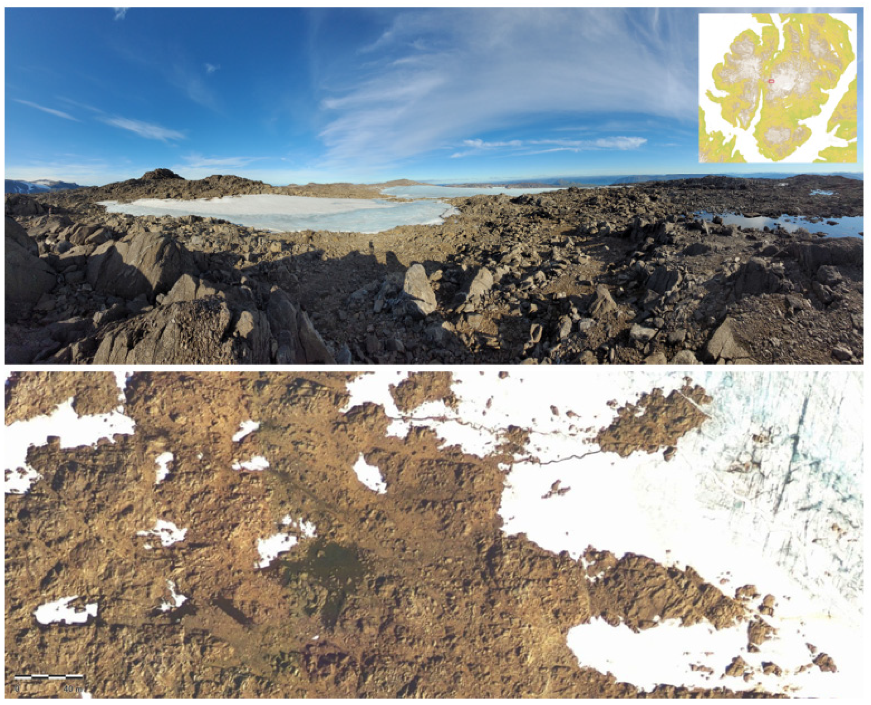
After unsuccessful survey hikes, we returned to Store Kufjord and scaled the pass. As a direct route across the island, the pass had early on attracted our attention. We had hypothesized that an ice patch marked on the 1895 map of Seiland might be archaeologically productive, considering that it provided an easily walkable surface in comparison with the surrounding slopes which are littered with boulders. The steep sides of the pass naturally direct passers-by over the patch, thus making it more likely that items would have ended up in the ice. LiDAR data showed remaining ice patches, some of which seemed to be remnants of larger ice accumulations. On closer inspection, however, we determined that the ice has completely melted away and that these patches now consist only of perennial snow (
Figure 5).
On the eastern plateau, the terrain was significantly more rugged than anticipated. Large boulder fields which were once covered in snow and ice are now an obstacle for both humans and reindeer. The vegetation is scarce above 600 m a.s.l., which makes moving easier, but reindeer tracks only occasionally provide a clear path towards the plateau. Around the edge of Seilandsjøkulen, vegetation is largely absent and the lichen free zone stretches for several hundred meters as a further testimony of rapidly retreating ice (
Figure 6). Perennial snow patches and snow-free ice margins were surveyed, but without success. Close to the pass, we were able to document several archaeological structures made from local stone. Recent artifacts made from wood (cut or carved sticks and branches) were clearly of anthropogenic origin and were thus documented. All of the items were found far removed from solid ice and thus can be assumed to be of modern date as they had plastic parts or industrially manufactured nails associated with them. The first snowfall arrived earlier than expected and prematurely ended the survey efforts for the season, effectively hindering access to the western plateau.
Mindful of the quickly changing weather conditions, the second season started in mid-August of 2022. Apart from an arctic storm with wind speeds of 60 knt (Beaufort scale 11) which forced us to seek shelter in the harbor of Hammerfest, a fair-weather window allowed for several hikes up to the eastern plateau, this time approaching from the north through Jøfjord. We reached the edge of the glacier several times, but the extremely rugged terrain left by the receding ice made an organized survey along the ice edges unfeasible. Apart from small windblown wood fragments and an additional carved stick, no further artifacts were recovered. Plastic bottles and occasional cartridge cases show recent hunting and hiking activity in the area.
Newly Documented Archaeological Structures
While the survey was unsuccessful with regards to discovering archaeologically productive ice patches, a number of previously undocumented stone-made structures were found in vicinity of the main pass of the island (
Figure 7). These structures were not visible in any of the remote sensing data we employed. We had been alerted to possible archaeological structures on the ridge by the spokesperson of the western
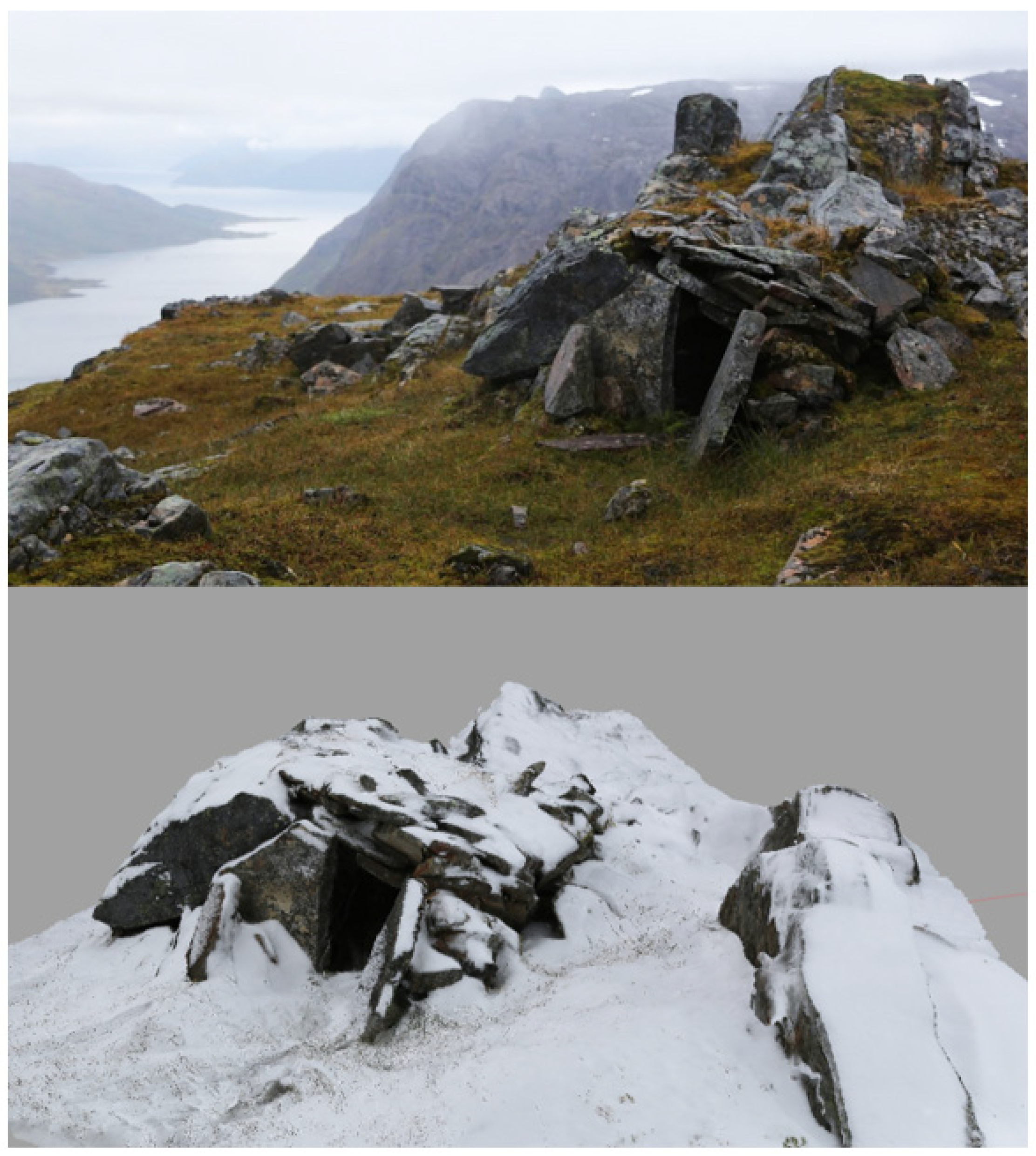
siida, Nils Henrik Sara, who mentioned his father and grandfather used them occasionally during the latter half of the 20th century. Due to the size of the structures and the fact that construction materials were taken from the immediate vicinity, they are not even discernable on the very high resolution orthophotographs of the Norwegian Mapping Authority. This once again shows the importance of conducting on-ground surveys when employing remote sensing methods in an archaeological context.
The eastern side of the pass is characterized by a steep cliff face and does not permit access to the eastern plateau. The western side, however, allows for hiking several steep steps to the western plateau and finding a connection to Bårdfjord on the western side of the island. Towards the north, passing a sequence of lakes, the shore of Jøfjord can be reached. The structures we identified are thus strategically located within the landscape and reachable from the north, south, and west. A series of small shelters had been built on the ridge overlooking the pass. Only one of them was found largely intact (
Figure 7). It might have been used for shelter until recently and is still useful in case of quickly emerging adverse weather events. The shelters use naturally occurring slabs and incorporate natural features into their outline, making even an on-ground detection difficult at times (
Figure 8).
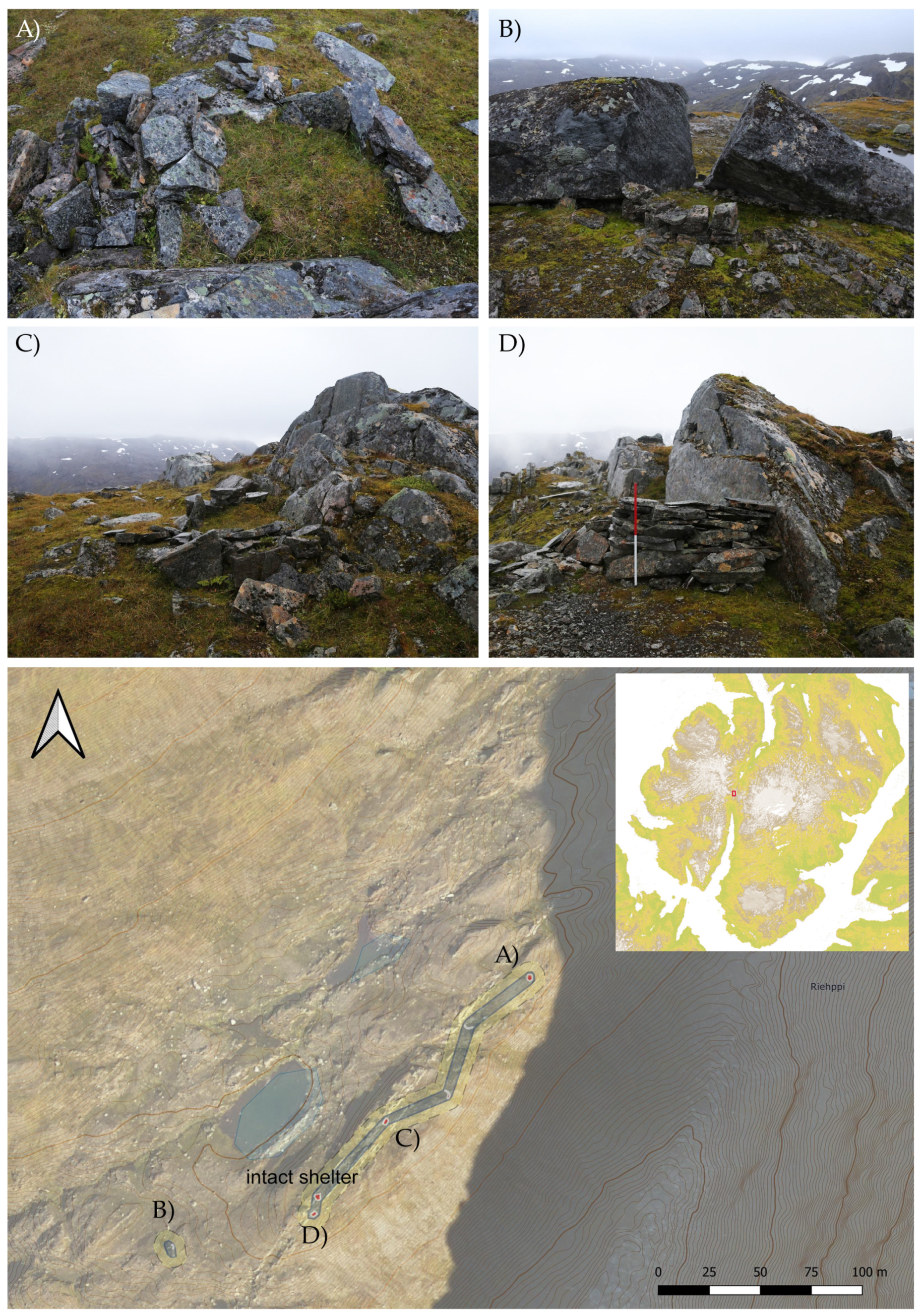
We documented four more structures (
Figure 8) which are possibly related to sheltering but might also have been used for hunting purposes. The area around the structures features a number of smaller ponds and moss-lichen coverage ideal for reindeer grazing, whereas around 50 m higher the landscape consists of bare rock and boulder fields where vegetation becomes increasingly sparse.
We excavated two 40 × 40 cm test pits inside structure (A) and structure (C) (
Figure 8). The layers at this altitude in the Arctic are very thin and comparable with what can be expected in Alpine contexts. The limited organic material is reused and mixed with plant roots, making the recovery of datable material difficult. Structure (C) did not yield any organic material which could be considered free of contaminants and thus suitable for dating. We were able to recover a ca. 1 cm long piece of charcoal from structure (A), clearly of anthropogenic origin, likely connected to a fire lit close to the entrance of the structure.
The radiocarbon date (
Table 1) for the charcoal piece found in the test pit unfortunately gives a wide range of possible calibrated dates for the structure. We used OxCal v4.4.4 [
42] with atmospheric data from [
43] to calibrate the date with the Intcal20 calibration curve and determined the following probabilities: 1670–1710 calCE (15.3%); 1718–1780 calCE (23.6%); 1797–1822 calCE (10.1%); and 19.6% probability for the sample dating to 1905 calCE or later.
6. Discussion
Chance finds of an iron and an antler arrowhead from the plateau had indicated that the inland plateau of Seiland had been used for hunting for potentially several thousands of years. The ice patches and glaciers of the island are receding quickly and potentially yielding archaeological finds including organics which are prone to decay once they are freed from the ice. While we were unable to locate further archaeological finds coming directly from the ice, we do not exclude that there are additional artifacts to be recovered. Unfortunately, we have been unsuccessful in identifying archaeologically productive ice patches. The pass crossing the island from north to south is completely ice free and only shows perennial snow patches which cover an area of large boulders. The extreme ruggedness of this terrain makes it very difficult to survey, and additional finds will likely only be made by chance. The pass is the only route on the island which would have been frequented regularly and where we thus would have expected larger accumulations of finds. Up on the high plateau, most finds are likely to be hunting related equipment. The loss of arrows and other material tends to be infrequent and the area which can be used for hunting is extensive. This leads to a situation in which only a few potential archaeological finds are spread over a wide area. Stone-built hunting blinds, which are a frequently observed structure in other parts of Finnmark, are largely unnecessary on the plateau, as there are many natural rock formations allowing a hunter to hide and stalk.
The extensive preparation for an exploratory glacial archaeology survey, however, has helped in defining areas of interest and planning the routes through the rugged terrain. Being able to identify non-moving ice patches beforehand, proved to be advantageous in reducing the survey area and singling out locations in which archaeological finds might have survived. Of course, simple least cost analyses based on slope cannot be taken as an accurate guidance for hikes, but in the often steep and rugged terrain of the island, they provide an indication of where animal tracks might be found. In arctic conditions with quickly changing weather on the plateau, precipitation and at times very bad visibility, these analyses also allow for orientation and focus during an exploratory survey. The employed ruggedness index in combination with high-resolution elevation models helped identify ice that is not exhibiting extensive dynamics which would destroy artifacts. This method could be easily applied to other glacial archaeological contexts and be useful in making a selection of survey sites if time and resource restrictions demand being selective.
The volatile weather on the plateau is likely also a reason for the construction of the archaeological structures we documented in the vicinity of the pass. It is not surprising that shelters were used throughout the past centuries on the high plateau of Seiland, but they constitute a new type of archaeological site in the island’s interior which has so far been unknown for archaeological structures. Reindeer herding has been an important economic activity in the region since at least the Late Middle Ages and thus herding and hunting related shelters should be expected at such a high altitude in the Arctic. The number of documented shelters is too small to merit a detailed typological analysis. They tend to be rectangular in shape and constructed from local stone. Where possible, they take into account natural features of the landscape and direct the entrance away from the main local wind directions. Organic material of anthropogenic origin was scarce in the test pits we excavated, but the dated context shows a usage of such structures possibly as early as the 17th century. More extensive surveys of the areas west of the pass might reveal additional structures as our documentation efforts were cut short by an early snow fall in the first week of September.
7. Conclusions
Despite not being successful in identifying archaeologically productive ice patches, we have applied and ground tested methods for incorporating remote sensing and GIS analyses into glacial archaeology surveys. The applied methods allow the narrowing down of the area of interest and identifying ice patches and glacier margins which do not display movement, thus increasing the chance of surviving organic finds. The survey of the island’s mountain pass led to the unexpected discovery of a new type of archaeological structure related to sheltering and possibly also hunting activities. Radiocarbon dating of charcoal obtained through test pitting likely places the usage of these structures in the past 200–300 years with continued usage into modern times. Although the application of remote sensing methods has not directly led to the identification and documentation of archaeological sites, it is a crucial component for the contextualization of the newly mapped structures. Conducting the survey also highlighted the importance of ground truthing areas that appear to be archaeologically empty, as many archaeological structures in high altitude and high latitude areas are faint and ephemeral, effectively hiding from the eye of the unknowing observer.
Author Contributions
Conceptualization, G.C.; methodology, G.C. and T.B.; software, G.C. and T.B.; validation, G.C., T.P.S. and N.S.; formal analysis, G.C. and T.P.S.; investigation, G.C., T.P.S., N.S. and T.B.; resources, G.C. and T.P.S.; data curation, G.C. and T.B.; writing—original draft preparation, G.C.; writing—review and editing, G.C., T.P.S., T.B. and N.S.; visualization, G.C. and T.P.S.; supervision, G.C.; project administration, G.C.; funding acquisition, G.C. All authors have read and agreed to the published version of the manuscript.
Funding
The field research was supported by an individual project grant of the Swiss Young Academy of Sciences as well as a Rolex Explorers Club Grant.
Data Availability Statement
All relevant data are contained within the manuscript.
Acknowledgments
The authors would like to thank citizen scientists B. Chan, A. Schorneck, M. Jeitziner, G. Caspari, and T. Røed as well as captain M. Halvorsen for data collection and expedition logistics. Some data were provided through SARchaeology: Exploiting Satellite SAR for Archaeological Prospection and Heritage Site Protection (ID. 58113).
Conflicts of Interest
The authors declare no conflict of interest.
References
- Hollesen, J.; Callanan, M.; Dawson, T.; Fenger-Nielsen, R.; Friesen, T.M.; Jensen, A.; Markham, A.; Martens, V.V.; Pitulko, V.; Rockman, M. Climate change and the deteriorating archaeological and environmental archives of the Arctic. Antiquity 2018, 92, 573–586. [Google Scholar] [CrossRef]
- Caspari, G. Tracking the Cold: Remote Sensing for Glacial Archaeology. J. Glacial Archaeol. 2021, 5, 85–102. [Google Scholar] [CrossRef]
- Hugonnet, R.; McNabb, R.; Berthier, E.; Menounos, B.; Nuth, C.; Girod, L.; Farinotti, D.; Huss, M.; Dussaillant, I.; Brun, F.; et al. Accelerated global glacier mass loss in the early twenty-first century. Nature 2021, 592, 726–731. [Google Scholar] [CrossRef]
- Barry, R.G. The status of research on glaciers and global glacier recession: A review. Prog. Phys. Geogr. Earth Environ. 2006, 30, 285–306. [Google Scholar] [CrossRef]
- Pachauri, R.K.; Allen, M.R.; Barros, V.R.; Broome, B.; Cramer, W.; Christ, R.; Church, J.A.; Clarke, L.; Dahe, Q.; Dasgupta, P.; et al. Climate Change 2014: Synthesis Report. Contribution of Working Groups I, II and III to the Fifth Assessment Report of the Intergov-Ernmental Panel on Climate Change; Cambridge University Press: Cambridge, UK; New York, NY, USA, 2013; p. 151. [Google Scholar]
- Farbregd, O. Glasial arkeologi. Nicolay-Arkeol. Tidskr. 1968, 4, 9–11. [Google Scholar]
- Dixon, E.J.; Callanan, M.E.; Hafner, A.; Hare, P.G. The emergence of glacial archaeology. J. Glacial Archaeol. 2014, 1, 1–9. [Google Scholar] [CrossRef]
- Seidler, H.; Bernhard, W.; Teschler-Nicola, M.; Platzer, W.; Zur Nedden, D.; Henn, R.; Oberhauser, A.; Sjovold, T. Some anthro-pological aspects of the prehistoric Tyrolean ice man. Science 1992, 258, 455–457. [Google Scholar] [CrossRef]
- Farnell, R.; Hare, P.G.; Blake, E.; Bowyer, V.; Schweger, C.; Greer, S.; Gotthardt, R. Multidisciplinary Investigations of Alpine Ice Patches in Southwest Yukon, Canada: Paleoenvironmental and Paleobiological Investigations. Arctic 2004, 57, 247–259. [Google Scholar] [CrossRef] [Green Version]
- Beattie, O.; Apland, B.; Blake, E.W.; Cosgrove, J.A.; Gaunt, S.; Greer, S.; Mackie, A.P.; Mackie, K.E.; Straathof, D.; Thorp, V.; et al. The Kwädāy Dän Ts’ ínchi discovery from a glacier in British Columbia. Can. J. Archaeol./J. Can. D’archéologie 2000, 24, 129–147. [Google Scholar]
- Dixon, E.J.; Manley, W.F.; Lee, C.M. The emerging archaeology of glaciers and ice patches: Examples from Alaska’s Wrangell-St. Elias National Park and Preserve. Am. Antiq. 2005, 70, 129–143. [Google Scholar] [CrossRef]
- Taylor, W.; Clark, J.K.; Reichhardt, B.; Hodgins, G.W.L.; Bayarsaikhan, J.; Batchuluun, O.; Whitworth, J.; Nansalmaa, M.; Lee, C.M.; Dixon, E.J. Investigating reindeer pastoralism and exploitation of high mountain zones in northern Mongolia through ice patch archaeology. PLoS ONE 2019, 14, e0224741. [Google Scholar] [CrossRef] [Green Version]
- Taylor, W.; Hart, I.; Pan, C.; Bayarsaikhan, J.; Murdoch, J.; Caspari, G.; Klinge, I.; Pearson, K.; Bikhumar, U.; Shnaider, S.; et al. High altitude hunting, climate change, and pastoral resilience in eastern Eurasia. Sci. Rep. 2021, 11, 14287. [Google Scholar] [CrossRef]
- Pilø, L.; Finstad, E.; Wammer, E.U.; Post-Melbye, J.R.; Rømer, A.H.; Andersen, R.; Barrett, J.H. On a Mountain High: Finding and Documenting Glacial Archaeological Sites During the Anthropocene. J. Field Archaeol. 2022, 47, 149–163. [Google Scholar] [CrossRef]
- Callanan, M. Central Norwegian Snow Patch Archaeology: Patterns Past and Present. Arctic 2012, 65, 178–188. [Google Scholar] [CrossRef] [Green Version]
- Pilø, L.; Finstad, E.; Ramsey, C.B.; Martinsen, J.P.R.; Nesje, A.; Solli, B.; Wangen, V.; Callanan, M.; Barrett, J.H. The chronology of reindeer hunting on Norway’s highest ice patches. R. Soc. Open Sci. 2018, 5, 171738. [Google Scholar] [CrossRef] [Green Version]
- Pilø, L.; Finstad, E.; Barrett, J.H. Crossing the ice: An Iron Age to medieval mountain pass at Lendbreen, Norway. Antiquity 2020, 94, 437–454. [Google Scholar] [CrossRef] [Green Version]
- Vedeler, M.; Jørgensen, L.B. Out of the Norwegian glaciers: Lendbreen—A tunic from the early first millennium AD. Antiquity 2013, 87, 788–801. [Google Scholar] [CrossRef] [Green Version]
- Jacobsen, R. Sørøysund Lokalhistorie; Sørøysund Kommune: Hammerfest, Norway, 1983. [Google Scholar]
- Ford, D.C. Seilandsjøkulen and Nordmannsjøkulen, Finnmark, Norway. J. Glaciol. 1958, 3, 249–252. [Google Scholar] [CrossRef] [Green Version]
- Andreassen, L.M.; Nagy, T.; Kjøllmoen, B.; Leigh, J.R. Glacier Area Outline 2018–2019. 2022. Available online: https://nve.brage.unit.no/nve-xmlui/handle/11250/2836926 (accessed on 26 February 2022).
- Andreassen, R.L.; Mydske, N. Rapport Fra Kulturminneregistrering, LNG-Terminal i Nord-Norge; Tromsø Museum. Available online: https://www.nb.no/items/904301420622b7dbf928b48c98f19851 (accessed on 26 February 2022).
- Johansen, H.M. Gaver fra sør og andre tegn på kontakt og felleskap. Flytting og forandringi Finnmarks fortid. Artik. Fra Mus. I Finnmark 2002, 12–127. [Google Scholar]
- Vorren, Ø. Finnmarksamenes nomadisme I & II; Universitetsforlaget: Tromso, Norway; Bergen, Norway; Oslo, Norway, 1962; p. 2. [Google Scholar]
- Vorren, Ø.; Manker, E. Samekulturen. En Kulturhistorisk Oversikt; Universitetsforlaget: Tromso, Norway; Bergen, Norway; Oslo, Norway, 1976. [Google Scholar]
- Hansen, L.-I.; Olsen, B. Samenes Historie Fram Til 1750; Cappelen Akademisk: Oslo, Norway, 2004; p. 1. [Google Scholar]
- Damm, C.B.; Skandfer, M.; Jørgensen, E.K.; Sjögren, P.; Vollan, K.W.; Jordan, P.D. Investigating long-term human ecodynamics in the European Arctic: Towards an integrated multi-scalar analysis of early and mid Holocene cultural, environmental and palaeodemographic sequences in Finnmark County, Northern Norway. Quat. Int. 2020, 549, 52–64. [Google Scholar] [CrossRef]
- Hansen, L.I. The Overlapping Taxation Areas of the North and the Nature of the Russian-Norwegian Border in Medieval and Early Modern Times. In Russia—Norway. Physical and Symbolic Borders; Jackson, J., Nielsen, J., Eds.; In Languages of Slavonic Culture; 2005; pp. 40–62. Available online: http://www.lrc-press.ru/pics/previews/ru/(791)blok%20Jackson-2005.pdf (accessed on 26 February 2022).
- Amundsen, C.; Henriksen, J.; Myrvoll, E.; Olsen, B.; Urbanczyk, P. Crossing borders: Multi-room houses and interethnic contacts in Europe’s extreme North’. Fennosc. Archaeol. 2003, 20, 79–100. [Google Scholar]
- Nilsen, G. Marine Mammal Train Oil Production Methods: Experimental Reconstructions of Norwegian Iron Age Slab-Lined Pits. J. Marit. Archaeol. 2016, 11, 197–217. [Google Scholar] [CrossRef] [Green Version]
- Myrvoll, E.R.; Thuestad, A.; Holm-Olsen, I.M. Wild reindeer hunting in Arctic Norway: Landscape, reindeer migration patterns and the distribution of hunting pits in Finnmark. Fennosc. Archaeol. 2011, XXVIII, 3–17. [Google Scholar]
- Bjørnstad, G.; Flagstad, Ø.; Hufthammer, A.K.; Røed, K.H. Ancient DNA reveals a major genetic change during the transition from hunting economy to reindeer husbandry in northern Scandinavia. J. Archaeol. Sci. 2012, 39, 102–108. [Google Scholar] [CrossRef]
- Alterauge, A.; Providoli, S.; Moghaddam, N.; Lösch, S. Death in the Ice: Re-investigations of the Remains from the Theodul Glacier (Switzerland). J. Glacial Archaeol. 2015, 2, 35–50. [Google Scholar] [CrossRef]
- Riley, S.J.; DeGloria, S.D.; Elliot, R. Index that quantifies topographic heterogeneity. Intermt. J. Sci. 1999, 5, 23–27. [Google Scholar]
- Caspari, G.; Donato, S.; Jendryke, M. Remote sensing and citizen science for assessing land use change in the Musandam (Oman). J. Arid. Environ. 2019, 171, 104003. [Google Scholar] [CrossRef]
- Pan, C.G.; Pope, A.; Kamp, U.; Dashtseren, A.; Walther, M.; Syromyatina, M.V. Glacier recession in the Altai Mountains of Mongolia in 1990–2016. Geogr. Ann. Ser. A Phys. Geogr. 2018, 100, 185–203. [Google Scholar] [CrossRef]
- Bishop, M.P.; Olsenholler, J.A.; Shroder, J.F.; Barry, R.G.; Raup, B.H.; Bush, A.B.; Copland, L.; Dwyer, J.L.; Fountain, A.G.; Wessels, R.; et al. Global Land Ice Measurements from Space (GLIMS): Remote sensing and GIS investigations of the Earth’s cryosphere. Geocarto Int. 2004, 19, 57–84. [Google Scholar] [CrossRef]
- Bhambri, R.; Bolch, T. Glacier mapping: A review with special reference to the Indian Himalayas. Prog. Phys. Geogr. Earth Environ. 2009, 33, 672–704. [Google Scholar] [CrossRef] [Green Version]
- Xiao, X.; Shen, Z.; Qin, X. Assessing the potential of VEGETATION sensor data for mapping snow and ice cover: A Normalized Difference Snow and Ice Index. Int. J. Remote Sens. 2001, 22, 2479–2487. [Google Scholar] [CrossRef]
- Rees, W. Least-cost paths in mountainous terrain. Comput. Geosci. 2004, 30, 203–209. [Google Scholar] [CrossRef]
- Herzog, I. A review of case studies in archaeological least-cost analysis. Archeol. E Calc. 2014, 25, 223–239. [Google Scholar]
- Bronk Ramsey, C. Bayesian Analysis of Radiocarbon Dates. Radiocarbon 2009, 51, 337–360. [Google Scholar] [CrossRef] [Green Version]
- Reimer, P.J.; Austin, W.E.N.; Bard, E.; Bayliss, A.; Blackwell, P.G.; Ramsey, C.B.; Butzin, M.; Cheng, H.; Edwards, R.L.; Friedrich, M.; et al. The IntCal20 Northern Hemisphere Radiocarbon Age Calibration Curve (0–55 cal kBP). Radiocarbon 2020, 62, 725–757. [Google Scholar] [CrossRef]
| Disclaimer/Publisher’s Note: The statements, opinions and data contained in all publications are solely those of the individual author(s) and contributor(s) and not of MDPI and/or the editor(s). MDPI and/or the editor(s) disclaim responsibility for any injury to people or property resulting from any ideas, methods, instructions or products referred to in the content. |
© 2023 by the authors. Licensee MDPI, Basel, Switzerland. This article is an open access article distributed under the terms and conditions of the Creative Commons Attribution (CC BY) license (https://creativecommons.org/licenses/by/4.0/).


