
Benchmarking Different SfM-MVS Photogrammetric and iOS LiDAR Acquisition Methods for the Digital Preservation of a Short-Lived Excavation: A Case Study from an Area of Sinkhole Related Subsidence

 , ,
, ,  ,
,  and
and
Abstract
:1. Introduction
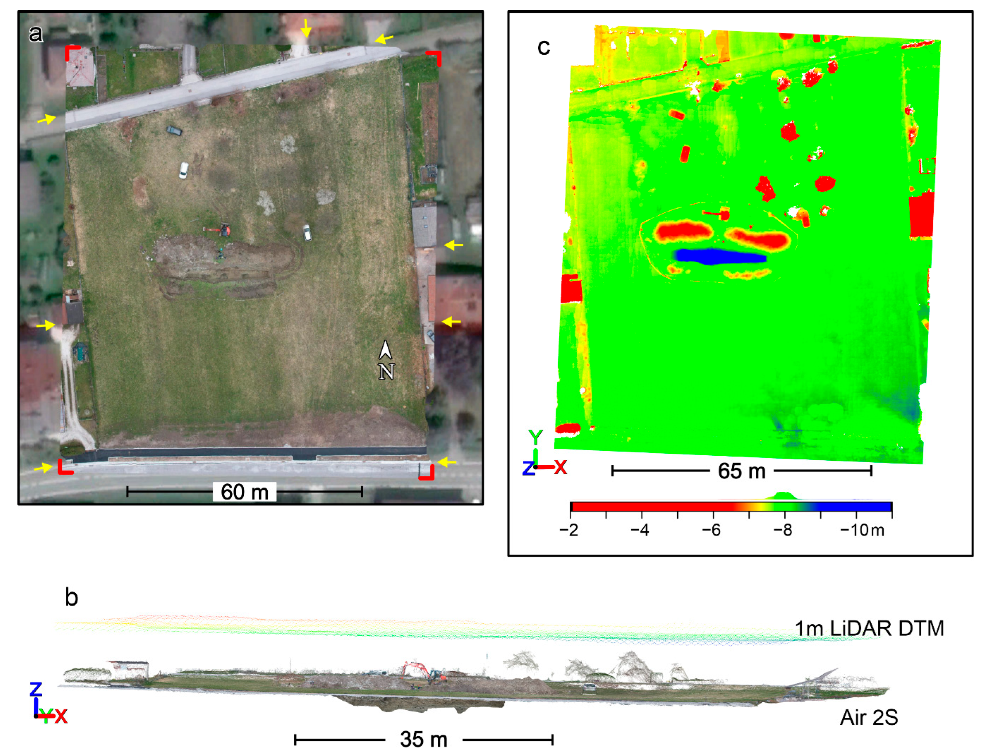
2. Methods
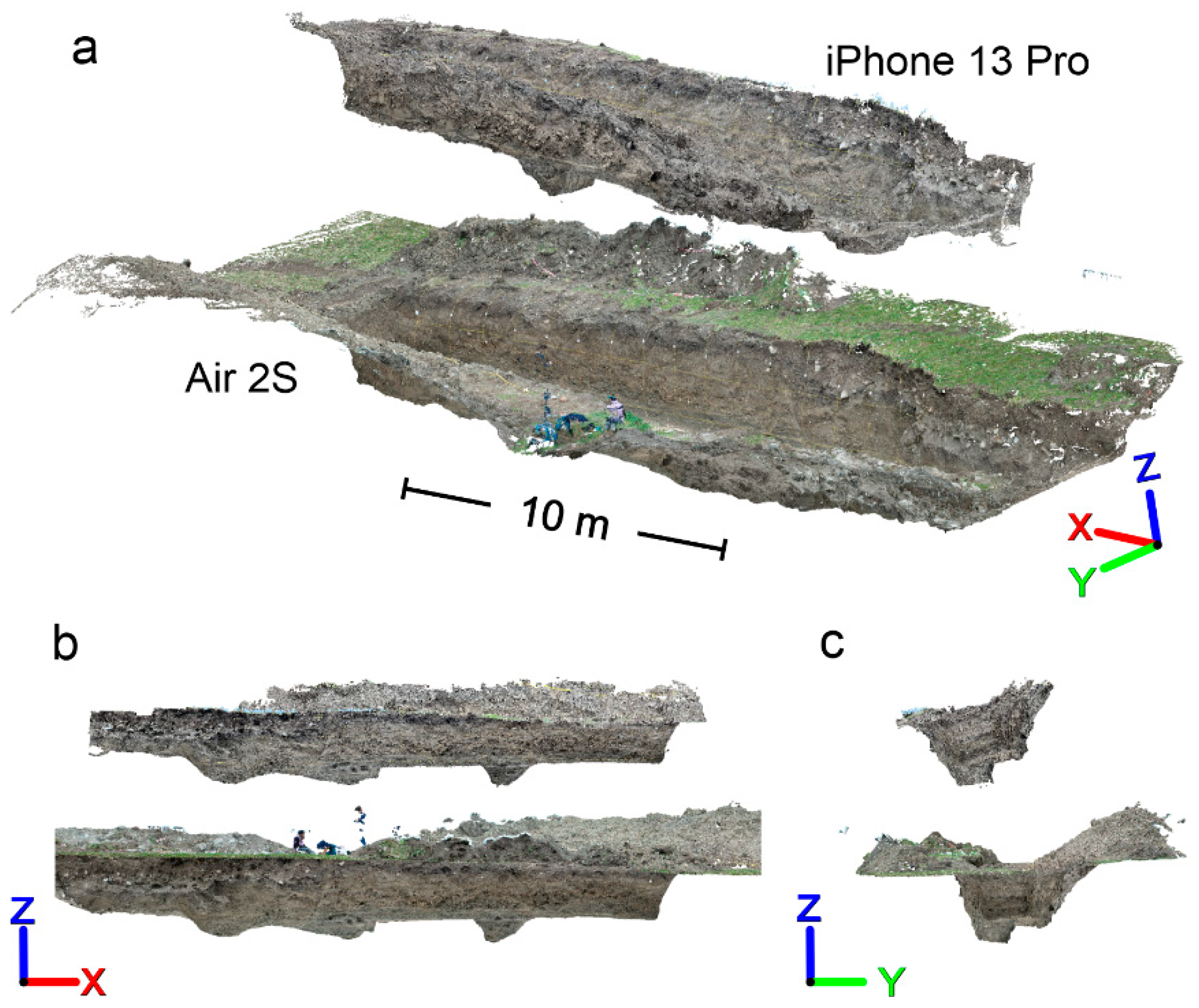
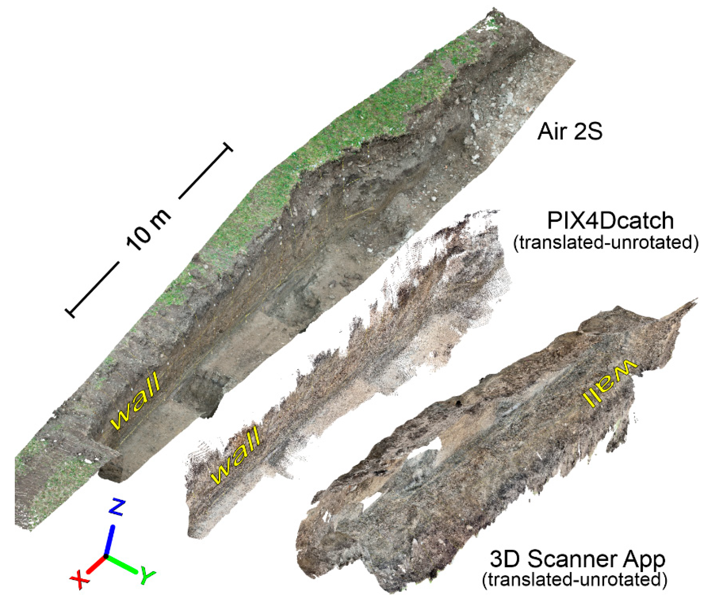
3. Processing Outline and Results
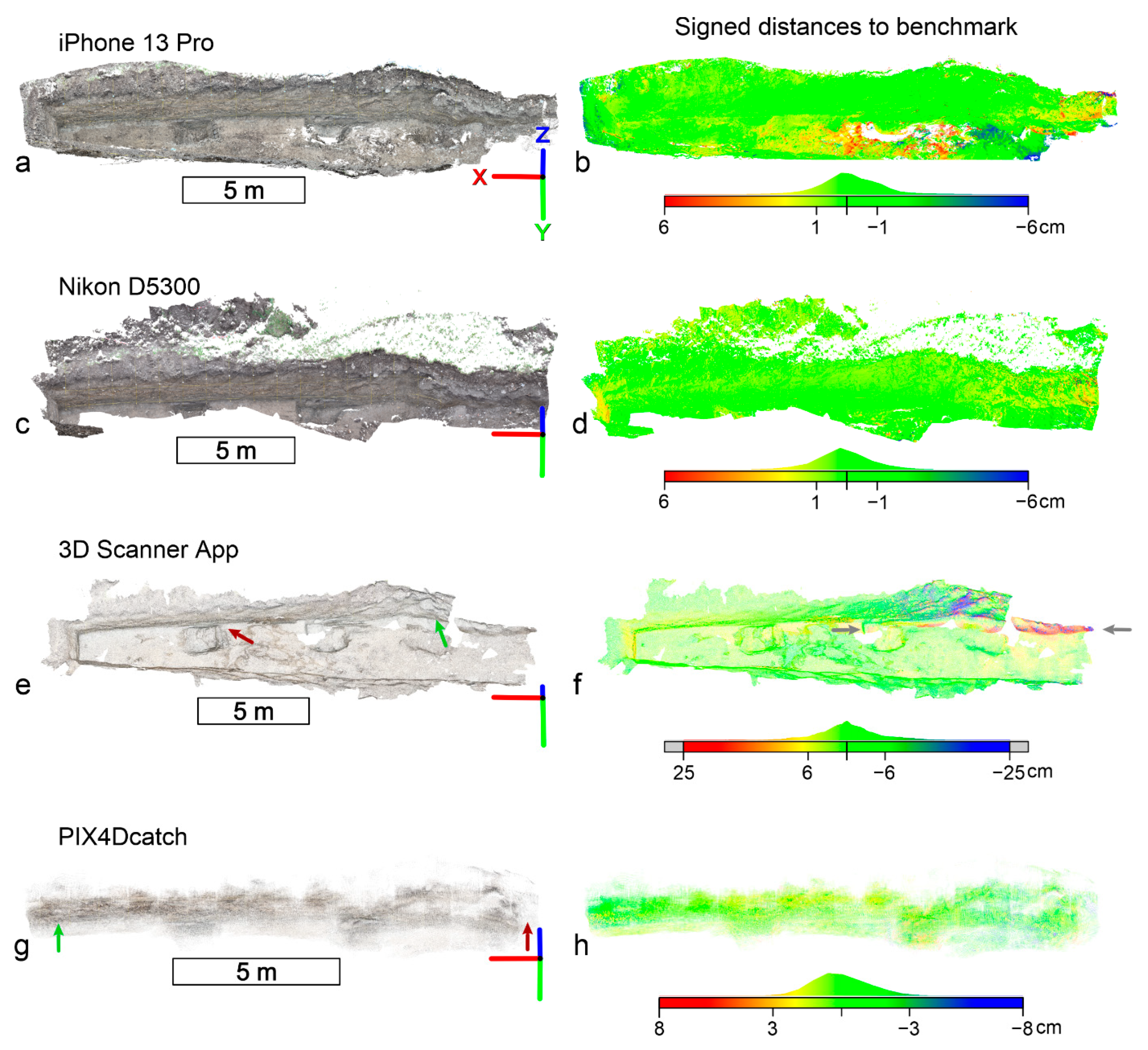
3.1. Comparative Analysis in CloudCompare
3.2. Orthomosaics
4. Discussion
4.1. Scaling and Orientation Accuracy of SfM-MVS Models
4.2. Scaling and Orientation Accuracy of the iPhone LiDAR Reconstructions
4.3. Internal Accuracy of Reconstructions
4.4. Orthopanels
4.5. Final Remarks
5. Conclusions
Author Contributions
Funding
Data Availability Statement
Acknowledgments
Conflicts of Interest
References
- Pavlis, T.L.; Langford, R.; Hurtado, J.; Serpa, L. Computer-Based Data Acquisition and Visualization Systems in Field Geology: Results from 12 Years of Experimentation and Future Potential. Geosphere 2010, 6, 275–294. [Google Scholar] [CrossRef]
- Micheletti, N.; Chandler, J.H.; Lane, S.N. Investigating the Geomorphological Potential of Freely Available and Accessible Structure-from-Motion Photogrammetry Using a Smartphone. Earth Surf. Process. Landf. 2015, 40, 473–486. [Google Scholar] [CrossRef] [Green Version]
- Jaud, M.; Kervot, M.; Delacourt, C.; Bertin, S. Potential of Smartphone SfM Photogrammetry to Measure Coastal Morphodynamics. Remote Sens. 2019, 11, 2242. [Google Scholar] [CrossRef] [Green Version]
- Corradetti, A.; Seers, T.D.; Billi, A.; Tavani, S. Virtual Outcrops in a Pocket: The Smartphone as a Fully Equipped Photogrammetric Data Acquisition Tool. GSA Today 2021, 31, 4–9. [Google Scholar] [CrossRef]
- Luetzenburg, G.; Kroon, A.; Bjørk, A.A. Evaluation of the Apple IPhone 12 Pro LiDAR for an Application in Geosciences. Sci. Rep. 2021, 11, 22221. [Google Scholar] [CrossRef] [PubMed]
- An, P.; Fang, K.; Zhang, Y.; Jiang, Y.; Yang, Y. Assessment of the Trueness and Precision of Smartphone Photogrammetry for Rock Joint Roughness Measurement. Meas. J. Int. Meas. Confed. 2022, 188, 110598. [Google Scholar] [CrossRef]
- Tavani, S.; Billi, A.; Corradetti, A.; Mercuri, M.; Bosman, A.; Cuffaro, M.; Seers, T.D.; Carminati, E. Smartphone Assisted Fieldwork: Towards the Digital Transition of Geoscience Fieldwork Using LiDAR-Equipped IPhones. Earth Sci. Rev. 2022, 227, 103969. [Google Scholar] [CrossRef]
- Devoto, S.; Macovaz, V.; Mantovani, M.; Soldati, M.; Furlani, S. Advantages of Using UAV Digital Photogrammetry in the Study of Slow-Moving Coastal Landslides. Remote Sens. 2020, 12, 3566. [Google Scholar] [CrossRef]
- Panara, Y.; Menegoni, N.; Carboni, F.; Inama, R. 3D Digital Outcrop Model-Based Analysis of Fracture Network along the Seismogenic Mt. Vettore Fault System (Central Italy): The Importance of Inherited Fractures. J. Struct. Geol. 2022, 161, 104654. [Google Scholar] [CrossRef]
- Prabhakaran, R.; Urai, J.L.; Bertotti, G.; Weismüller, C.; Smeulders, D.M.J. Large-Scale Natural Fracture Network Patterns: Insights from Automated Mapping in the Lilstock (Bristol Channel) Limestone Outcrops. J. Struct. Geol. 2021, 150, 104405. [Google Scholar] [CrossRef]
- Xu, X.; Aiken, C.L.V.; Bhattacharya, J.P.; Corbeanu, R.M.; Nielsen, K.C.; McMechan, G.A.; Abdelsalam, M.G. Creating Virtual 3-D Outcrop. Lead. Edge 2000, 19, 197–202. [Google Scholar] [CrossRef]
- Pringle, J.K.; Clark, J.D.; Westerman, A.R.; Stanbrook, D.A.; Gardiner, A.R.; Morgan, B.E.F. Virtual Outcrops: 3-D Reservoir Analogues. J. Virtual Explor. 2001, 4, 51–55. [Google Scholar] [CrossRef]
- Bellian, J.A.; Kerans, C.; Jennette, D.C. Digital Outcrop Models: Applications of Terrestrial Scanning Lidar Technology in Stratigraphic Modeling. J. Sediment. Res. 2005, 75, 166–176. [Google Scholar] [CrossRef] [Green Version]
- McCaffrey, K.J.W.; Jones, R.R.; Holdsworth, R.E.; Wilson, R.W.; Clegg, P.; Imber, J.; Holliman, N.; Trinks, I. Unlocking the Spatial Dimension: Digital Technologies and the Future of Geoscience Fieldwork. J. Geol. Soc. London. 2005, 162, 927–938. [Google Scholar] [CrossRef] [Green Version]
- Buckley, S.J.; Enge, H.D.; Carlsson, C.; Howell, J.A. Terrestrial Laser Scanning for Use in Virtual Outcrop Geology. Photogramm. Rec. 2010, 25, 225–239. [Google Scholar] [CrossRef]
- Jones, R.R.; Pringle, J.K.; McCaffrey, K.J.W.; Imber, J.; Wightman, R.H.; Guo, J.; Long, J.J. Extending Digital Outcrop Geology into the Subsurface. In CSP010 Outcrops Revitalized: Tools, Techniques and Applications; Martinsen, O.J., Pulham, A.J., Haughton, P., Sullivan, M.D., Eds.; SEPM (Society for Sedimentary Geology): Tulsa, OK, USA, 2011; pp. 31–50. ISBN 978-1-56576-306-7. [Google Scholar]
- Howell, J.A.; Martinius, A.W.; Good, T.R. The Application of Outcrop Analogues in Geological Modelling: A Review, Present Status and Future Outlook. Geol. Soc. Lond. Spec. Publ. 2014, 387, 1–25. [Google Scholar] [CrossRef]
- Inama, R.; Menegoni, N.; Perotti, C. Syndepositional Fractures and Architecture of the Lastoni Di Formin Carbonate Platform: Insights from Virtual Outcrop Models and Field Studies. Mar. Pet. Geol. 2020, 121, 104606. [Google Scholar] [CrossRef]
- Bonali, F.L.; Corti, N.; Russo, E.; Marchese, F.; Fallati, L.; Mariotto, F.P.; Tibaldi, A. Commercial-UAV-Based Structure from Motion for Geological and Geohazard Studies. In Building Knowledge for Geohazard Assessment and Management in the Caucasus and Other Orogenic Regions; Springer: Berlin/Heidelberg, Germany, 2021; pp. 389–427. [Google Scholar]
- Uradziński, M.; Bakuła, M. Assessment of Static Positioning Accuracy Using Low-Cost Smartphone GPS Devices for Geodetic Survey Points’ Determination and Monitoring. Appl. Sci. 2020, 10, 5308. [Google Scholar] [CrossRef]
- Tavani, S.; Corradetti, A.; Granado, P.; Snidero, M.; Seers, T.D.; Mazzoli, S. Smartphone: An Alternative to Ground Control Points for Orienting Virtual Outcrop Models and Assessing Their Quality. Geosphere 2019, 15, 2043–2052. [Google Scholar] [CrossRef] [Green Version]
- Tavani, S.; Pignalosa, A.; Corradetti, A.; Mercuri, M.; Smeraglia, L.; Riccardi, U.; Seers, T.D.; Pavlis, T.L.; Billi, A. Photogrammetric 3D Model via Smartphone GNSS Sensor: Workflow, Error Estimate, and Best Practices. Remote Sens. 2020, 12, 3616. [Google Scholar] [CrossRef]
- Tavani, S.; Granado, P.; Riccardi, U.; Seers, T.D.; Corradetti, A. Terrestrial SfM-MVS Photogrammetry from Smartphone Sensors. Geomorphology 2020, 367, 107318. [Google Scholar] [CrossRef]
- Fernández, O.; Muñoz, J.A.; Arbués, P.; Falivene, O.; Marzo, M. Three-Dimensional Reconstruction of Geological Surfaces: An Example of Growth Strata and Turbidite Systems from the Ainsa Basin (Pyrenees, Spain). Am. Assoc. Pet. Geol. Bull. 2004, 88, 1049–1068. [Google Scholar] [CrossRef]
- Bistacchi, A.; Griffith, W.A.; Smith, S.A.F.; Di Toro, G.; Jones, R.R.; Nielsen, S. Fault Roughness at Seismogenic Depths from LIDAR and Photogrammetric Analysis. Pure Appl. Geophys. 2011, 168, 2345–2363. [Google Scholar] [CrossRef]
- Vasuki, Y.; Holden, E.-J.; Kovesi, P.; Micklethwaite, S. Semi-Automatic Mapping of Geological Structures Using UAV-Based Photogrammetric Data: An Image Analysis Approach. Comput. Geosci. 2014, 69, 22–32. [Google Scholar] [CrossRef]
- Seers, T.D.; Hodgetts, D. Comparison of Digital Outcrop and Conventional Data Collection Approaches for the Characterization of Naturally Fractured Reservoir Analogues. Geol. Soc. London Spec. Publ. 2014, 374, 51–77. [Google Scholar] [CrossRef]
- Pavlis, T.L.; Mason, K.A. The New World of 3D Geologic Mapping. GSA Today 2017, 27, 4–10. [Google Scholar] [CrossRef]
- Seers, T.D.; Sheharyar, A.; Tavani, S.; Corradetti, A. Virtual Outcrop Geology Comes of Age: The Application of Consumer-Grade Virtual Reality Hardware and Software to Digital Outcrop Data Analysis. Comput. Geosci. 2022, 159, 105006. [Google Scholar] [CrossRef]
- Bemis, S.P.; Micklethwaite, S.; Turner, D.; James, M.R.; Akciz, S.; Thiele, S.T.; Bangash, H.A. Ground-Based and UAV-Based Photogrammetry: A Multi-Scale, High-Resolution Mapping Tool for Structural Geology and Paleoseismology. J. Struct. Geol. 2014, 69, 163–178. [Google Scholar] [CrossRef]
- Pringle, J.K.; Westerman, A.R.; Clark, J.D.; Drinkwater, N.J.; Gardiner, A.R. 3D High-Resolution Digital Models of Outcrop Analogue Study Sites to Constrain Reservoir Model Uncertainty: An Example from Alport Castles, Derbyshire, UK. Pet. Geosci. 2004, 10, 343–352. [Google Scholar] [CrossRef]
- Westoby, M.J.; Dunning, S.A.; Woodward, J.; Hein, A.S.; Marrero, S.M.; Winter, K.; Sugden, D.E. Instruments and Methods: Sedimentological Characterization of Antarctic Moraines Using Uavs and Structure-from-Motion Photogrammetry. J. Glaciol. 2015, 61, 1088–1102. [Google Scholar] [CrossRef]
- Nesbit, P.R.; Durkin, P.R.; Hugenholtz, C.H.; Hubbard, S.M.; Kucharczyk, M. 3-D Stratigraphic Mapping Using a Digital Outcrop Model Derived from UAV Images and Structure-from-Motion Photogrammetry. Geosphere 2018, 14, 2469–2486. [Google Scholar] [CrossRef] [Green Version]
- Favalli, M.; Fornaciai, A.; Mazzarini, F.; Harris, A.; Neri, M.; Behncke, B.; Pareschi, M.T.; Tarquini, S.; Boschi, E. Evolution of an Active Lava Flow Field Using a Multitemporal LIDAR Acquisition. J. Geophys. Res. Solid Earth 2010, 115, B11. [Google Scholar] [CrossRef] [Green Version]
- Brodu, N.; Lague, D. 3D Terrestrial Lidar Data Classification of Complex Natural Scenes Using a Multi-Scale Dimensionality Criterion: Applications in Geomorphology. ISPRS J. Photogramm. Remote Sens. 2012, 68, 121–134. [Google Scholar] [CrossRef] [Green Version]
- Carrivick, J.L.; Smith, M.W. Fluvial and Aquatic Applications of Structure from Motion Photogrammetry and Unmanned Aerial Vehicle/Drone Technology. WIREs Water 2019, 6, 1–17. [Google Scholar] [CrossRef] [Green Version]
- Turner, D.; Lucieer, A.; de Jong, S.M. Time Series Analysis of Landslide Dynamics Using an Unmanned Aerial Vehicle (UAV). Remote Sens. 2015, 7, 1736. [Google Scholar] [CrossRef] [Green Version]
- Lucieer, A.; de Jong, S.M.; Turner, D. Mapping Landslide Displacements Using Structure from Motion (SfM) and Image Correlation of Multi-Temporal UAV Photography. Prog. Phys. Geogr. Earth Environ. 2014, 38, 97–116. [Google Scholar] [CrossRef]
- Fang, K.; An, P.; Tang, H.; Tu, J.; Jia, S.; Miao, M.; Dong, A. Application of a Multi-Smartphone Measurement System in Slope Model Tests. Eng. Geol. 2021, 295, 106424. [Google Scholar] [CrossRef]
- Fu, L.; Zhu, J.; Li, W.-L.; You, J.-G.; Hua, Z.-Y. Fast Estimation Method of Volumes of Landslide Deposit by the 3D Reconstruction of Smartphone Images. Landslides 2021, 18, 3269–3278. [Google Scholar] [CrossRef]
- Santos, I.; Henriques, R.; Mariano, G.; Pereira, D.I. Methodologies to Represent and Promote the Geoheritage Using Unmanned Aerial Vehicles, Multimedia Technologies, and Augmented Reality. Geoheritage 2018, 10, 143–155. [Google Scholar] [CrossRef]
- Burnham, B.; Bond, C.; Flaig, P.; van der Kolk, D.; Hodgetts, D. Outcrop Conservation: Promoting Accessibility, Inclusivity, and Reproducibility through Digital Preservation. Sediment. Rec. 2022, 20, 5–14. [Google Scholar] [CrossRef]
- Reitman, N.G.; Bennett, S.E.K.; Gold, R.D.; Briggs, R.W.; DuRoss, C.B. High-Resolution Trench Photomosaics from Image-Based Modeling: Workflow and Error Analysis. Bull. Seismol. Soc. Am. 2015, 105, 2354–2366. [Google Scholar] [CrossRef]
- Carrera, C.C.; Asensio, L.A.B. Augmented Reality as a Digital Teaching Environment to Develop Spatial Thinking. Cartogr. Geogr. Inf. Sci. 2017, 44, 259–270. [Google Scholar] [CrossRef]
- Whitmeyer, S.J.; Atchinson, C.; Collins, T.D. Using Mobile Technologies to Enhance Accessibility and Inclusion in Field- Based Learning Enhance Accessibility and Inclusion. GSA Today 2020, 30, 4–10. [Google Scholar] [CrossRef]
- Bond, C.E.; Cawood, A.J. A Role for Virtual Outcrop Models in Blended Learning–Improved 3D Thinking and Positive Perceptions of Learning. Geosci. Commun. 2021, 4, 233–244. [Google Scholar] [CrossRef]
- Uzkeda, H.; Poblet, J.; Magán, M.; Bulnes, M.; Martín, S.; Fernández-Martínez, D. Virtual Outcrop Models: Digital Techniques and an Inventory of Structural Models from North-Northwest Iberia (Cantabrian Zone and Asturian Basin). J. Struct. Geol. 2022, 157, 104568. [Google Scholar] [CrossRef]
- Eusden, J.D.; Duvall, M.; Bryant, M. Google Earth Mashup of the Geology in the Presidential Range, New Hampshire: Linking Real and Virtual Field Trips for an Introductory Geology Class. Geol. Soc. Am. Spec. Pap. 2012, 492, 355–366. [Google Scholar]
- Cliffe, A.D. A Review of the Benefits and Drawbacks to Virtual Field Guides in Today’s Geoscience Higher Education Environment. Int. J. Educ. Technol. High. Educ. 2017, 14. [Google Scholar] [CrossRef] [Green Version]
- Harknett, J.; Whitworth, M.; Rust, D.; Krokos, M.; Kearl, M.; Tibaldi, A.; Bonali, F.L.; Van Wyk de Vries, B.; Antoniou, V.; Nomikou, P.; et al. The Use of Immersive Virtual Reality for Teaching Fieldwork Skills in Complex Structural Terrains. J. Struct. Geol. 2022, 163, 104681. [Google Scholar] [CrossRef]
- Pugsley, J.H.; Howell, J.A.; Hartley, A.; Buckley, S.J.; Brackenridge, R.; Schofield, N.; Maxwell, G.; Chmielewska, M.; Ringdal, K.; Naumann, N.; et al. Virtual Field Trips Utilizing Virtual Outcrop: Construction, Delivery and Implications for the Future. Geosci. Commun. 2022, 5, 227–249. [Google Scholar] [CrossRef]
- Rutkofske, J.E.; Pavlis, T.L.; Ramirez, S. Applications of Modern Digital Mapping Systems to Assist Inclusion of Persons with Disabilities in Geoscience Education and Research. J. Struct. Geol. 2022, 161, 104655. [Google Scholar] [CrossRef]
- Cawood, A.; Bond, C. ERock: An Open-Access Repository of Virtual Outcrops for Geoscience Education. GSA Today 2019, 29, 36–37. [Google Scholar] [CrossRef]
- Senger, K.; Betlem, P.; Birchall, T.; Buckley, S.J.; Coakley, B.; Eide, C.H.; Flaig, P.P.; Forien, M.; Galland, O.; Gonzaga, L.; et al. Using Digital Outcrops to Make the High Arctic More Accessible through the Svalbox Database. J. Geosci. Educ. 2021, 69, 123–137. [Google Scholar] [CrossRef]
- Buckley, S.J.; Howell, J.A.; Naumann, N.; Lewis, C.; Chmielewska, M.; Ringdal, K.; Vanbiervliet, J.; Tong, B.; Mulelid-Tynes, O.S.; Foster, D.; et al. V3Geo: A Cloud-Based Repository for Virtual 3D Models in Geoscience. Geosci. Commun. 2022, 5, 67–82. [Google Scholar] [CrossRef]
- Zini, L.; Calligaris, C.; Forte, E.; Petronio, L.; Zavagno, E.; Boccali, C.; Cucchi, F. A Multidisciplinary Approach in Sinkhole Analysis: The Quinis Village Case Study (NE-Italy). Eng. Geol. 2015, 197, 132–144. [Google Scholar] [CrossRef]
- Busetti, A.; Calligaris, C.; Forte, E.; Areggi, G.; Mocnik, A.; Zini, L. Non-Invasive Methodological Approach to Detect and Characterize High-Risk Sinkholes in Urban Cover Evaporite Karst: Integrated Reflection Seismics, PS-INSAR, Leveling, 3D-GPR and Ancillary Data. a Ne Italian Case Study. Remote Sens. 2020, 12, 3814. [Google Scholar] [CrossRef]
- Gortani, M. Le Doline Alluvionali. Nat. Mont. 1965, 3, 120–128. [Google Scholar]
- Calligaris, C.; Devoto, S.; Galve, J.P.; Zini, L.; Pérez-Peña, J.V. Integration of Multi-Criteria and Nearest Neighbour Analysis with Kernel Density Functions for Improving Sinkhole Susceptibility Models: The Case Study of Enemonzo (NE Italy). Int. J. Speleol. 2017, 46, 191–204. [Google Scholar] [CrossRef] [Green Version]
- Calligaris, C.; Devoto, S.; Zini, L. Evaporite Sinkholes of the Friuli Venezia Giulia Region (NE Italy). J. Maps 2017, 13, 406–414. [Google Scholar] [CrossRef] [Green Version]
- Gutiérrez, F.; Guerrero, J.; Lucha, P. A Genetic Classification of Sinkholes Illustrated from Evaporite Paleokarst Exposures in Spain. Environ. Geol. 2008, 53, 993–1006. [Google Scholar] [CrossRef]
- Gutiérrez, F.; Parise, M.; De Waele, J.; Jourde, H. A Review on Natural and Human-Induced Geohazards and Impacts in Karst. Earth-Sci. Rev. 2014, 138, 61–88. [Google Scholar] [CrossRef]
- Girardeau-Montaut, D. Cloud Compare—3D Point Cloud and Mesh Processing Software. Available online: https://www.danielgm.net/cc/ (accessed on 17 April 2022).
- Chase, P.P.C.; Clarke, K.H.; Hawkes, A.J.; Jabari, S.; Jakus, J.S. Apple IPhone 13 Pro Lidar Accuracy Assessment for Engineering Applications. In Proceedings of the 2022: The Digital Reality of Tomorrow, Fredericton, NB, Canada, 23–25 August 2022; pp. 1–10. [Google Scholar]
- Sanz-Ablanedo, E.; Chandler, J.H.; Rodríguez-Pérez, J.R.; Ordóñez, C. Accuracy of Unmanned Aerial Vehicle (UAV) and SfM Photogrammetry Survey as a Function of the Number and Location of Ground Control Points Used. Remote Sens. 2018, 10, 1606. [Google Scholar] [CrossRef] [Green Version]
- Buckley, S.J.; Ringdal, K.; Naumann, N.; Dolva, B.; Kurz, T.H.; Howell, J.A.; Dewez, T.J.B. LIME: Software for 3-D Visualization, Interpretation, and Communication of Virtual Geoscience Models. Geosphere 2019, 15, 222–235. [Google Scholar] [CrossRef]
- Verhoeven, G. Taking Computer Vision Aloft—Archaeological Three-Dimensional Reconstructions from Aerial Photographs with Photoscan. Archaeol. Prospect. 2011, 18, 67–73. [Google Scholar] [CrossRef]
- Remondino, F. Heritage Recording and 3D Modeling with Photogrammetry and 3D Scanning. Remote Sens. 2011, 3, 1104. [Google Scholar] [CrossRef] [Green Version]
- Ruggles, S.; Clark, J.; Franke, K.W.; Wolfe, D.; Reimschiissel, B.; Martin, R.A.; Okeson, T.J.; Hedengren, J.D. Comparison of Sfm Computer Vision Point Clouds of a Landslide Derived from Multiple Small Uav Platforms and Sensors to a Tls-Based Model. J. Unmanned Veh. Syst. 2016, 4, 246–265. [Google Scholar] [CrossRef]
- Kelly, J.; Sukhatme, G.S. Visual-Inertial Sensor Fusion: Localization, Mapping and Sensor-to-Sensor Self-Calibration. Int. J. Rob. Res. 2011, 30, 56–79. [Google Scholar] [CrossRef] [Green Version]
- James, M.R.; Robson, S. Mitigating Systematic Error in Topographic Models Derived from UAV and Ground-Based Image Networks. Earth Surf. Process. Landf. 2014, 39, 1413–1420. [Google Scholar] [CrossRef] [Green Version]
- Niethammer, U.; James, M.R.; Rothmund, S.; Travelletti, J.; Joswig, M. UAV-Based Remote Sensing of the Super-Sauze Landslide: Evaluation and Results. Eng. Geol. 2012, 128, 2–11. [Google Scholar] [CrossRef]
- Tavani, S.; Corradetti, A.; Billi, A. High Precision Analysis of an Embryonic Extensional Fault-Related Fold Using 3D Orthorectified Virtual Outcrops: The Viewpoint Importance in Structural Geology. J. Struct. Geol. 2016, 86, 200–210. [Google Scholar] [CrossRef]
- Menegoni, N.; Inama, R.; Crozi, M.; Perotti, C. Early Deformation Structures Connected to the Progradation of a Carbonate Platform: The Case of the Nuvolau Cassian Platform (Dolomites—Italy). Mar. Pet. Geol. 2022, 138, 105574. [Google Scholar] [CrossRef]
- Gattolin, G.; Preto, N.; Breda, A.; Franceschi, M.; Isotton, M.; Gianolla, P. Sequence Stratigraphy after the Demise of a High-Relief Carbonate Platform (Carnian of the Dolomites): Sea-Level and Climate Disentangled. Palaeogeogr. Palaeoclimatol. Palaeoecol. 2015, 423, 1–17. [Google Scholar] [CrossRef]
- Corradetti, A.; Tavani, S.; Russo, M.; Arbués, P.C.; Granado, P. Quantitative Analysis of Folds by Means of Orthorectified Photogrammetric 3D Models: A Case Study from Mt. Catria, Northern Apennines, Italy. Photogramm. Rec. 2017, 32, 480–496. [Google Scholar] [CrossRef]
- Cawood, A.J.; Corradetti, A.; Granado, P.; Tavani, S. Detailed Structural Analysis of Digital Outcrops: A Learning Example from the Kermanshah-Qulqula Radiolarite Basin, Zagros Belt, Iran. J. Struct. Geol. 2022, 154, 104489. [Google Scholar] [CrossRef]
- Jablonska, D.; Pitts, A.; Di Celma, C.; Volatili, T.; Alsop, G.I.; Tondi, E. 3D Outcrop Modelling of Large Discordant Breccia Bodies in Basinal Carbonates of the Apulian Margin, Italy. Mar. Pet. Geol. 2021, 123, 104732. [Google Scholar] [CrossRef]
- McCaffrey, K.J.W.; Feely, M.; Hennessy, R.; Thompson, J. Visualization of Folding in Marble Outcrops, Connemara, Western Ireland: An Application of Virtual Outcrop Technology. Geosphere 2008, 4, 588. [Google Scholar] [CrossRef] [Green Version]
- Nesbit, P.R.; Boulding, A.D.; Hugenholtz, C.H.; Durkin, P.R.; Hubbard, S.M. Visualization and Sharing of 3D Digital Outcrop Models to Promote Open Science. GSA Today 2020, 30, 4–10. [Google Scholar] [CrossRef] [Green Version]
- Nesbit, P.R.; Hubbard, S.M.; Hugenholtz, C.H. Direct Georeferencing UAV-SfM in High-Relief Topography: Accuracy Assessment and Alternative Ground Control Strategies along Steep Inaccessible Rock Slopes. Remote Sens. 2022, 14, 490. [Google Scholar] [CrossRef]
- Thiele, S.T.; Grose, L.; Samsu, A.; Micklethwaite, S.; Vollgger, S.A.; Cruden, A.R. Rapid, Semi-Automatic Fracture and Contact Mapping for Point Clouds, Images and Geophysical Data. Solid Earth 2017, 8, 1241–1253. [Google Scholar] [CrossRef]


| Device | Positioning System | Sensor | Image Resolution | Lens Parameters | Production Year |
|---|---|---|---|---|---|
| DJI Air 2S | GPS + GLONASS + Galileo | 1” CMOS | 20 MP | f/2.8, 22 mm (35 mm equivalent) | 2021 |
| Nikon D5300 | GPS | CMOS APS-C | 24.2 MP | f/3.5–5.6 G VR | 2014 |
| iPhone 13 Pro | GPS + GLONASS + Galileo + QZSS + Beidou | dual pixel PDAF | 12.2 MP | 5.7 mm f/1.5, 26 mm (35 mm equivalent) | 2021 |
Publisher’s Note: MDPI stays neutral with regard to jurisdictional claims in published maps and institutional affiliations. |
© 2022 by the authors. Licensee MDPI, Basel, Switzerland. This article is an open access article distributed under the terms and conditions of the Creative Commons Attribution (CC BY) license (https://creativecommons.org/licenses/by/4.0/).
Share and Cite
Corradetti, A.; Seers, T.; Mercuri, M.; Calligaris, C.; Busetti, A.; Zini, L. Benchmarking Different SfM-MVS Photogrammetric and iOS LiDAR Acquisition Methods for the Digital Preservation of a Short-Lived Excavation: A Case Study from an Area of Sinkhole Related Subsidence. Remote Sens. 2022, 14, 5187. https://doi.org/10.3390/rs14205187
Corradetti A, Seers T, Mercuri M, Calligaris C, Busetti A, Zini L. Benchmarking Different SfM-MVS Photogrammetric and iOS LiDAR Acquisition Methods for the Digital Preservation of a Short-Lived Excavation: A Case Study from an Area of Sinkhole Related Subsidence. Remote Sensing. 2022; 14(20):5187. https://doi.org/10.3390/rs14205187
Chicago/Turabian StyleCorradetti, Amerigo, Thomas Seers, Marco Mercuri, Chiara Calligaris, Alice Busetti, and Luca Zini. 2022. "Benchmarking Different SfM-MVS Photogrammetric and iOS LiDAR Acquisition Methods for the Digital Preservation of a Short-Lived Excavation: A Case Study from an Area of Sinkhole Related Subsidence" Remote Sensing 14, no. 20: 5187. https://doi.org/10.3390/rs14205187