
Inundation Resilience Analysis of Metro-Network from a Complex System Perspective Using the Grid Hydrodynamic Model and FBWM Approach: A Case Study of Wuhan


Abstract
:
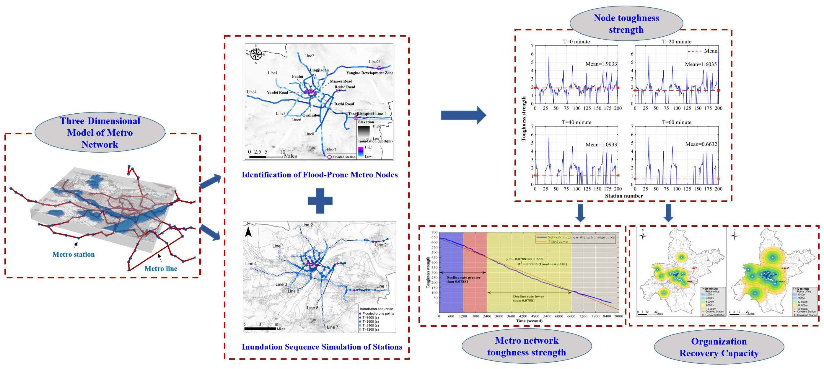
1. Introduction
2. Methodology and Materials
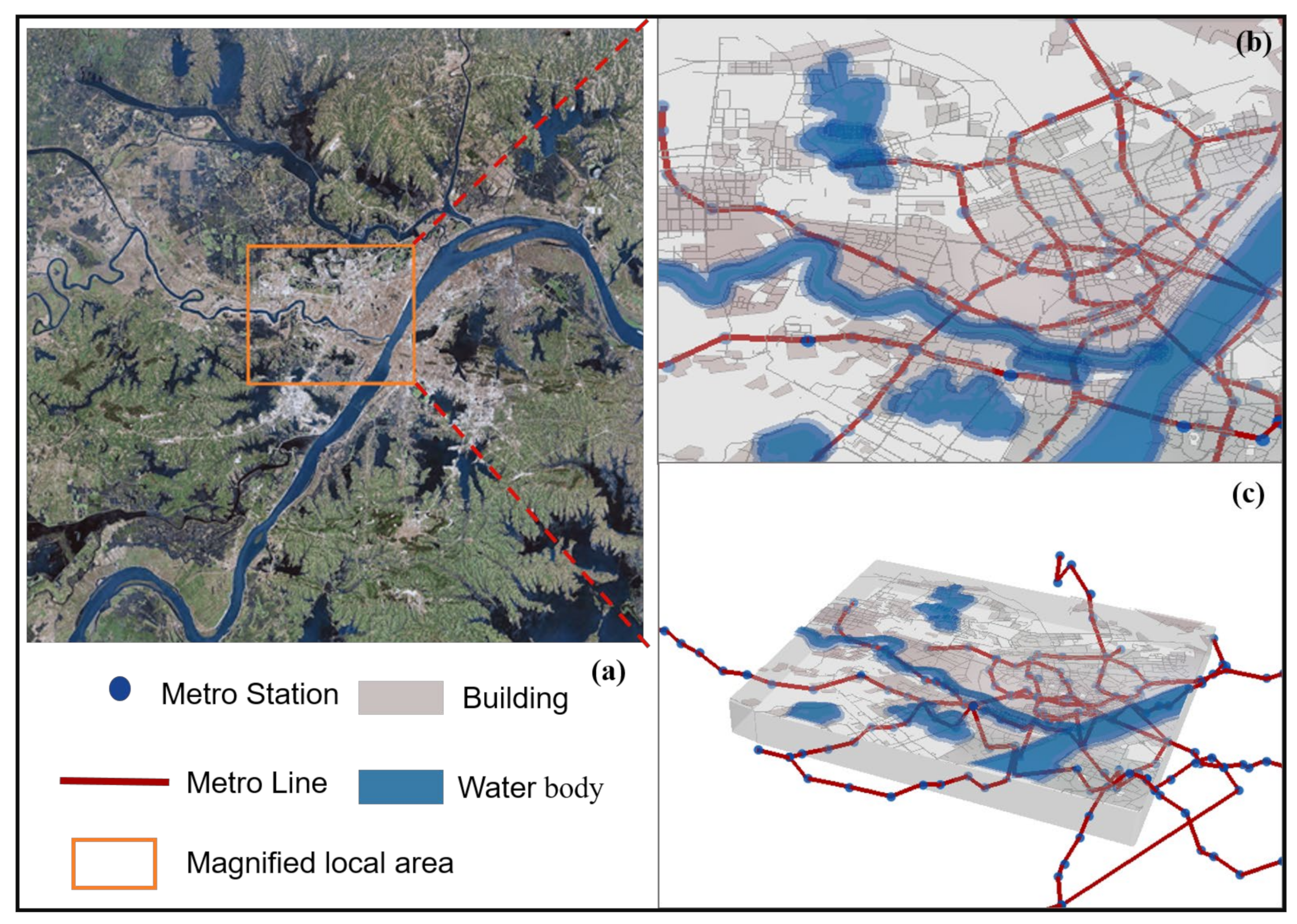
2.1. Study Area
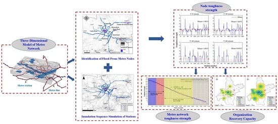
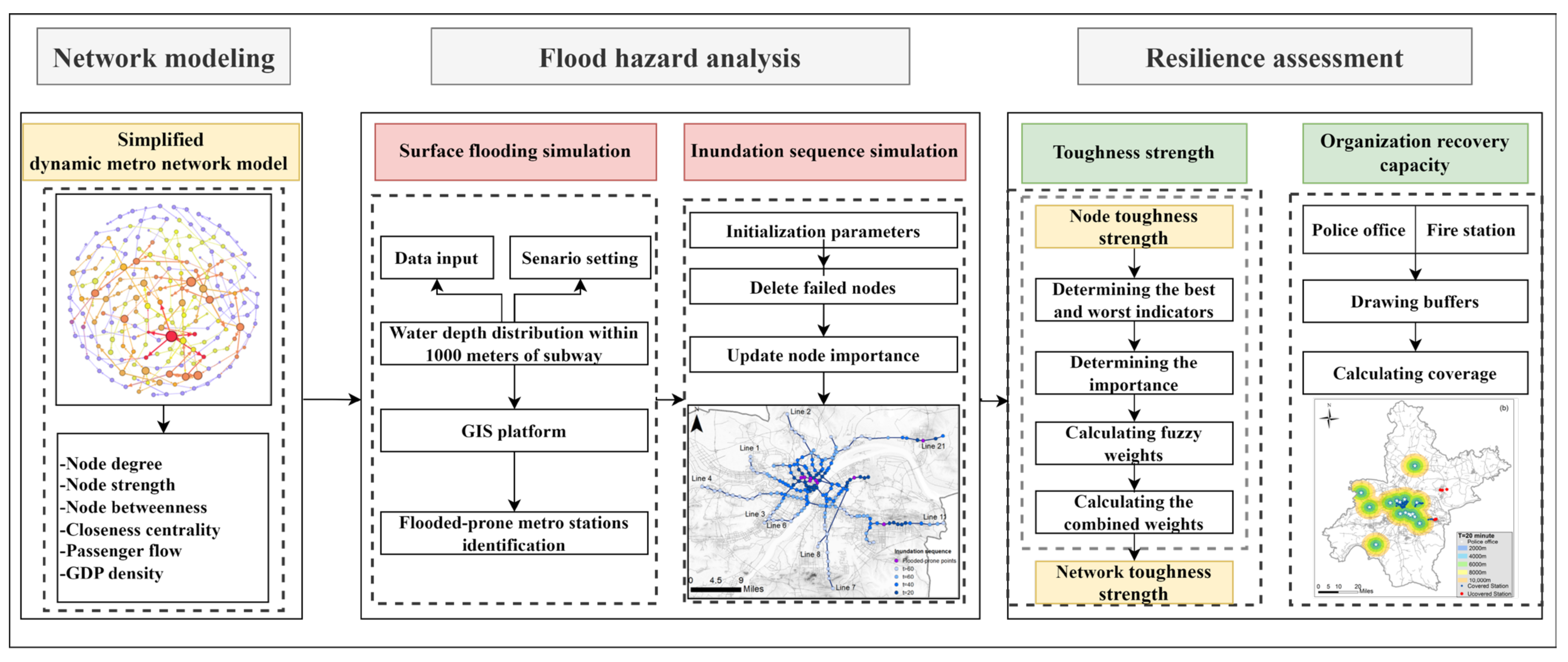
2.2. Network Modeling: Simplified Three-Dimensional Model of Metro Network under Flood Evolution Scenario
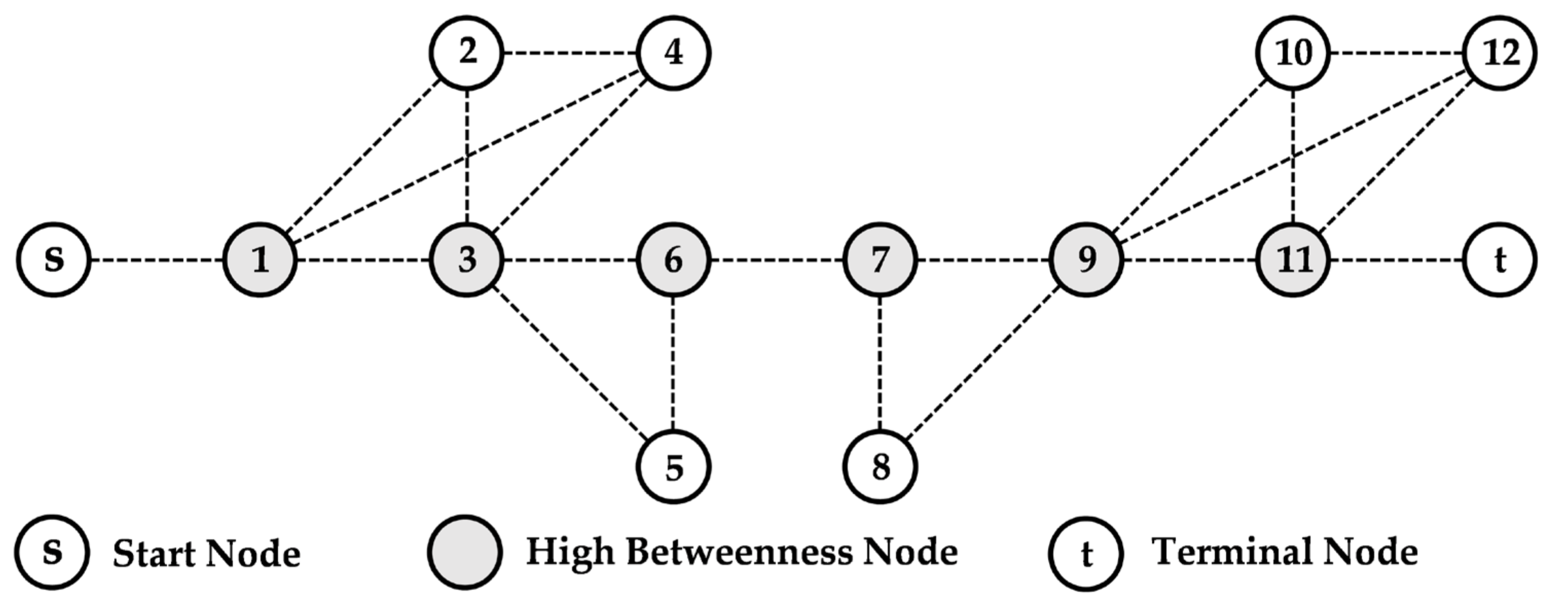
2.2.1. Basic Network
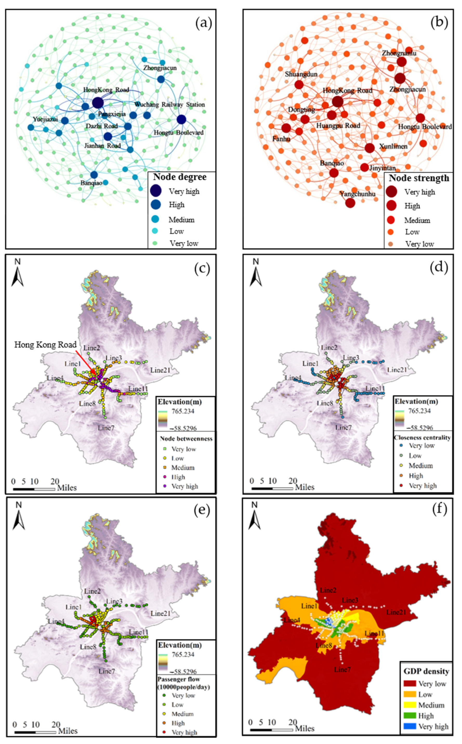
2.2.2. Node Characteristics
- Node Degree
- 2.
- Node Strength
- 3.
- Node Betweenness
- 4.
- Closeness Centrality
- 5.
- Passenger Flow
- 6.
- GDP Density
2.2.3. Node Toughness Strength
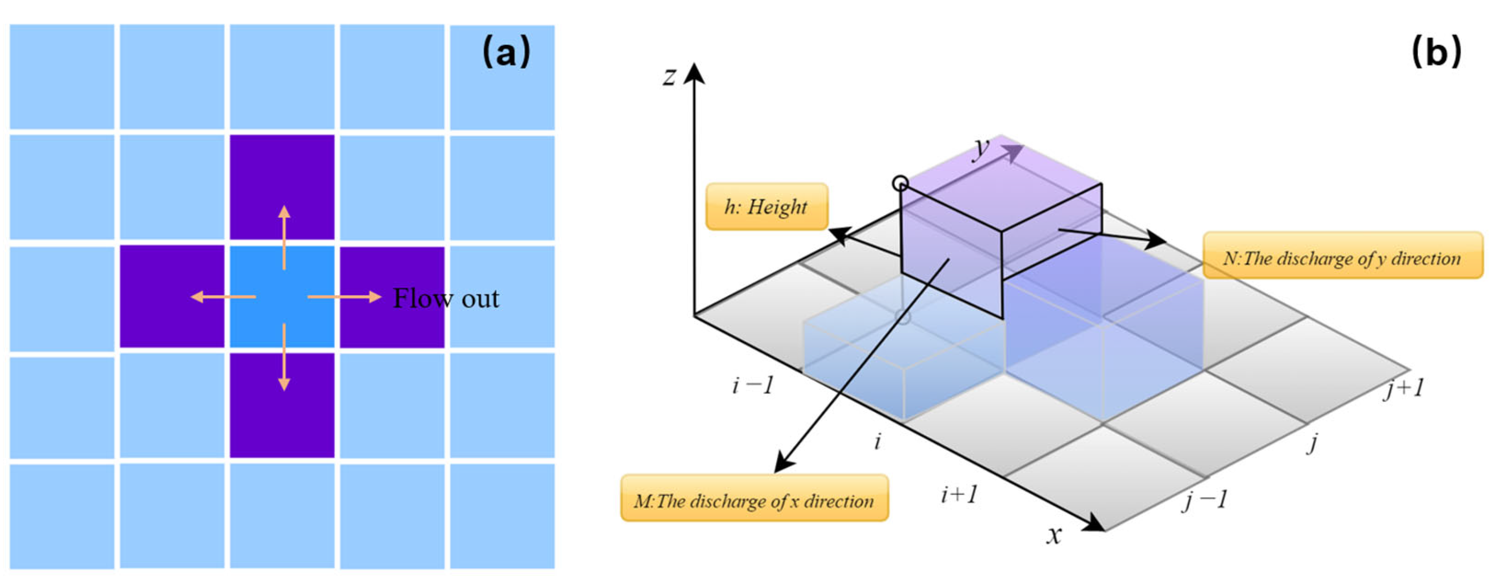
2.3. Flood Hazard Simulation
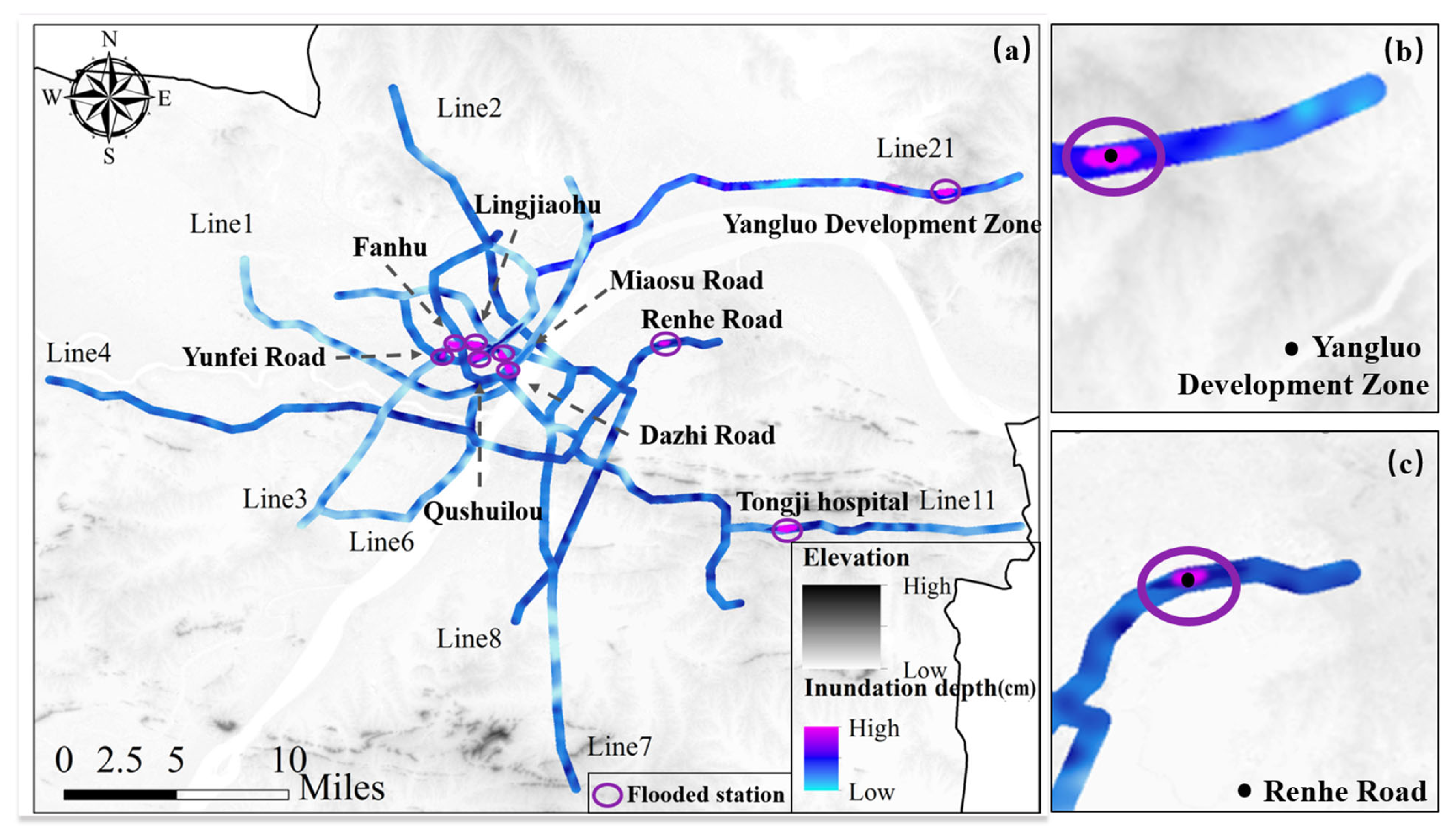
2.3.1. Surface Flooding Simulation: Identification of Flood-Prone Metro Nodes
- Inundation simulation
- 2.
- Rain design
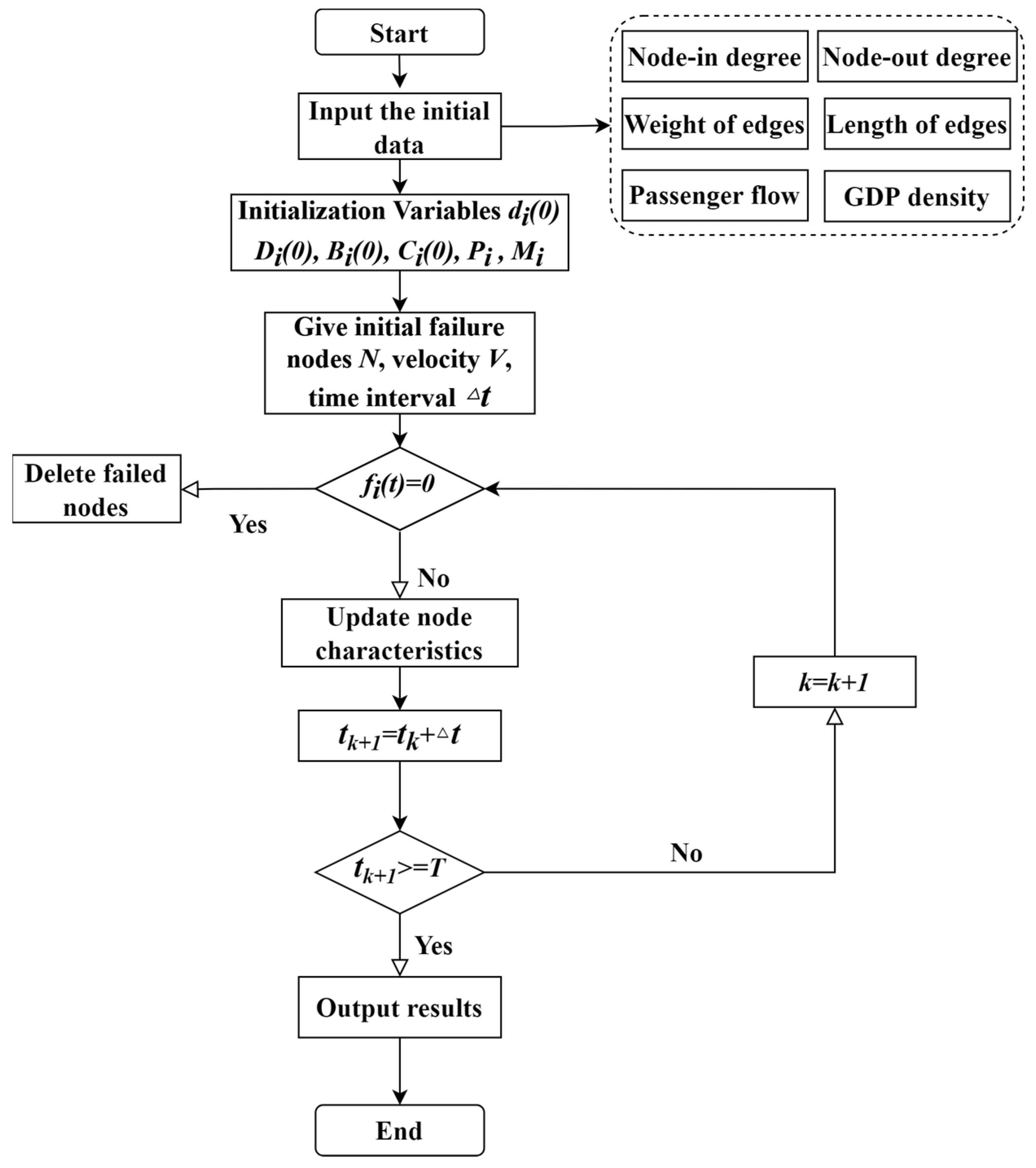
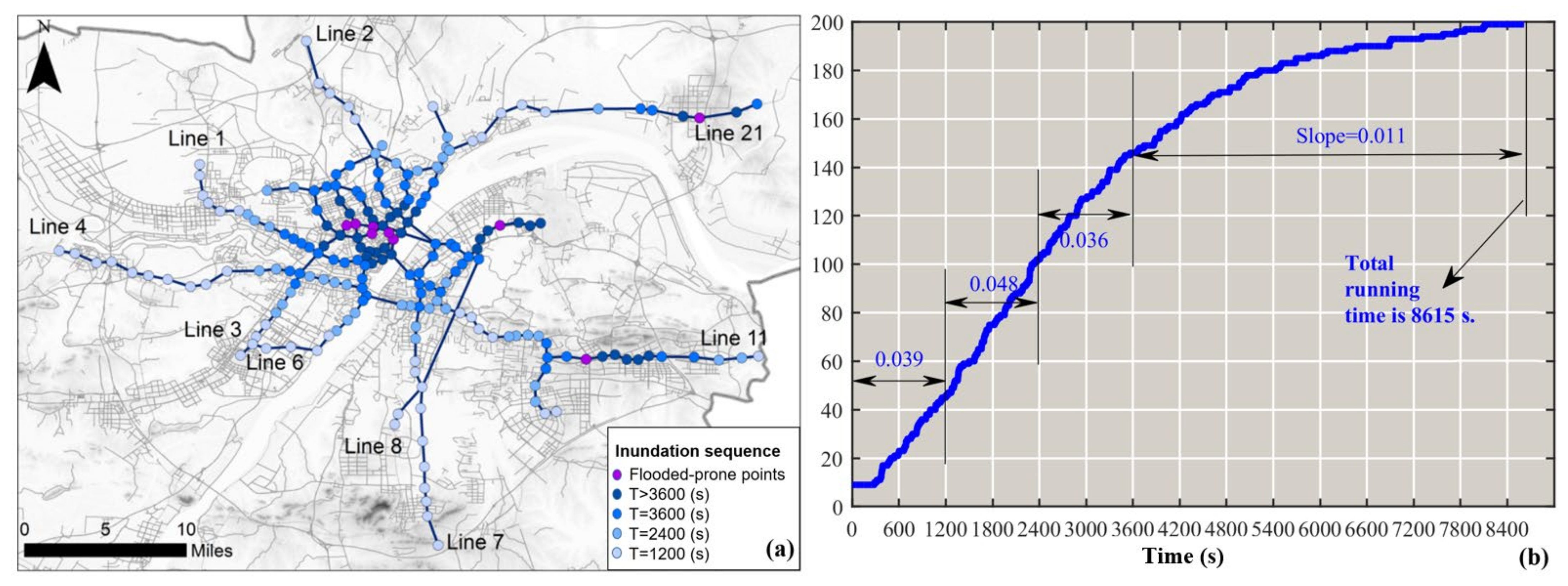
2.3.2. Inundation Sequence Simulation of Stations: Dynamic Node Breakdown Algorithm
2.4. Resilience Assessment Model of Metro Network
2.4.1. Toughness Strength Assessment Model for Metro Network
- ①
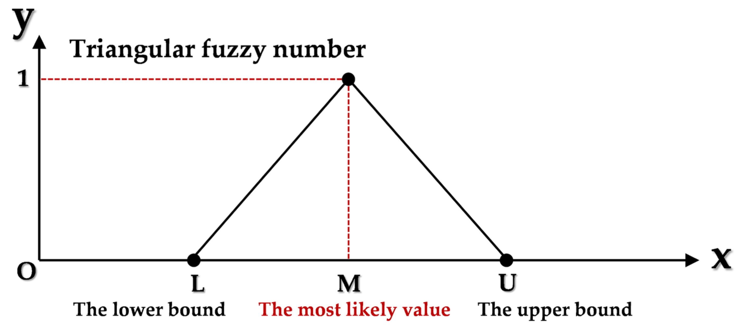
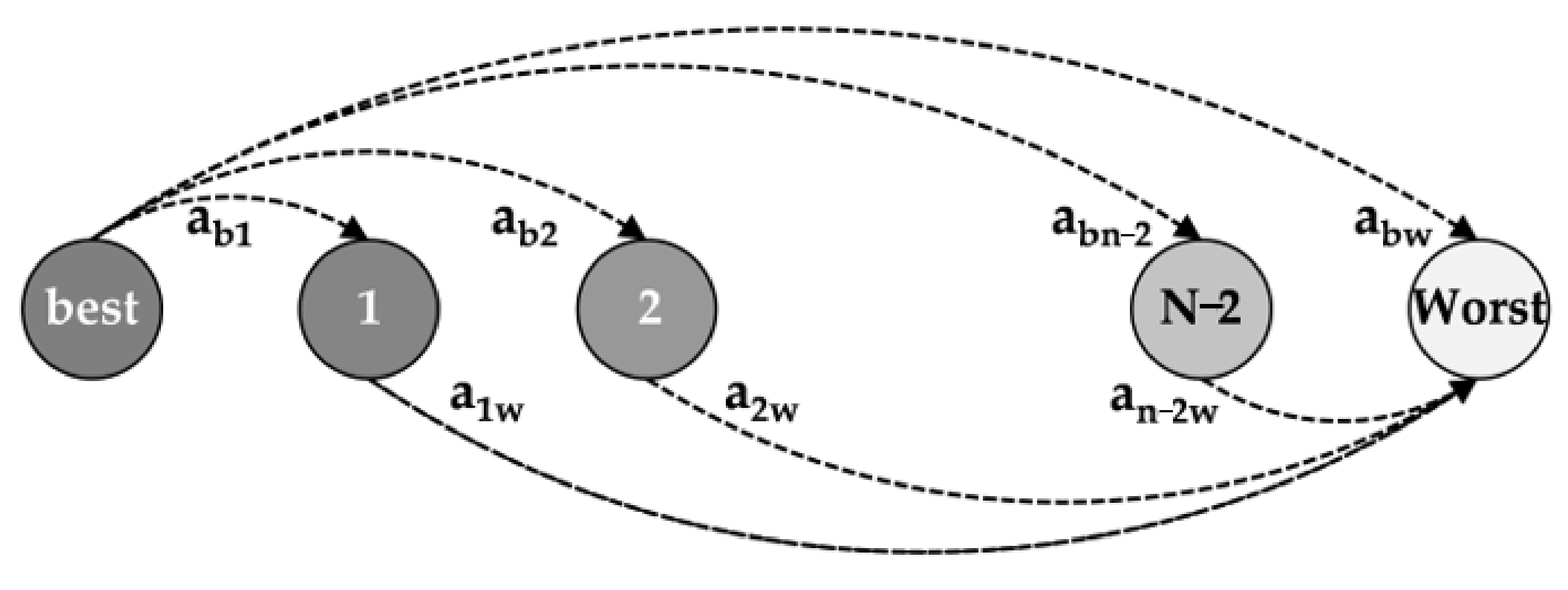
- Calculation of node toughness strength index weights: FBWM
- ②
- Toughness Strength of Metro Network
2.4.2. Organization Recovery Capacity of Metro Network
3. Results and Discussion
3.1. Data Source
3.2. Flood Hazard Analysis of Metro Network
3.2.1. Flooded Node Breakdown Analysis
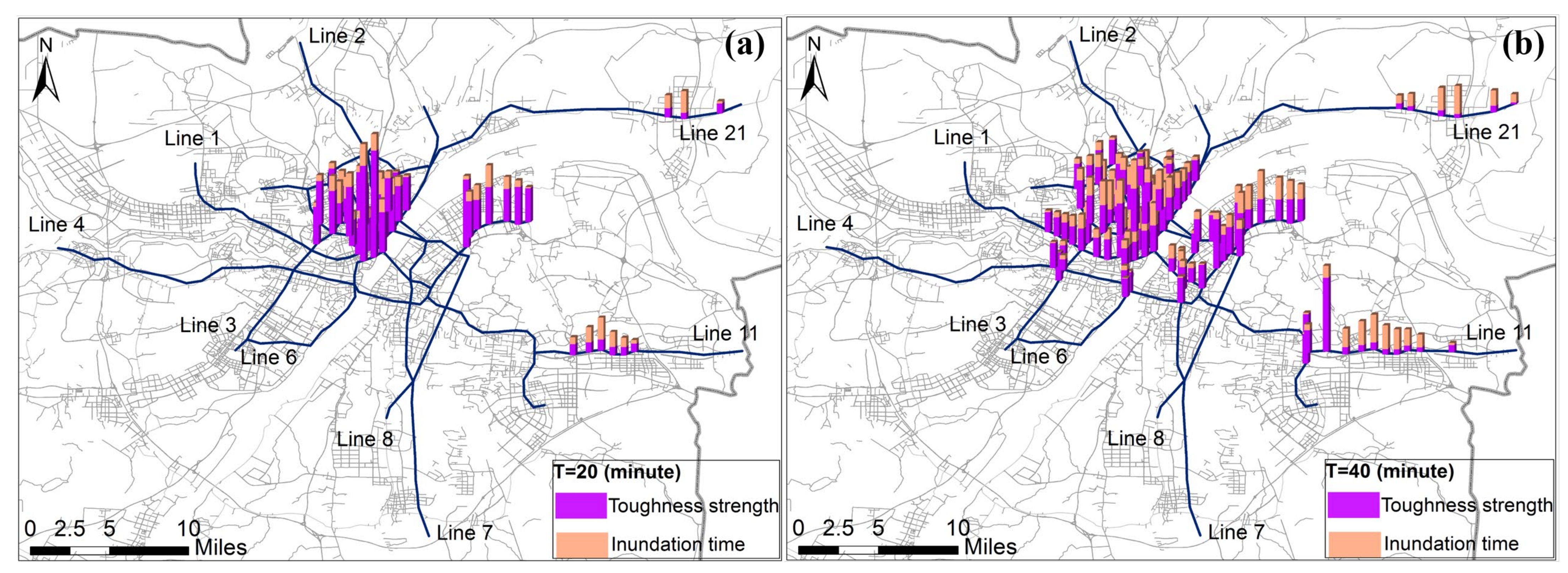
3.2.2. Node Dynamic Breakdown Process
3.3. Resilience Assessment of Metro Network
3.3.1. Evaluation of Node Toughness Strength Weights
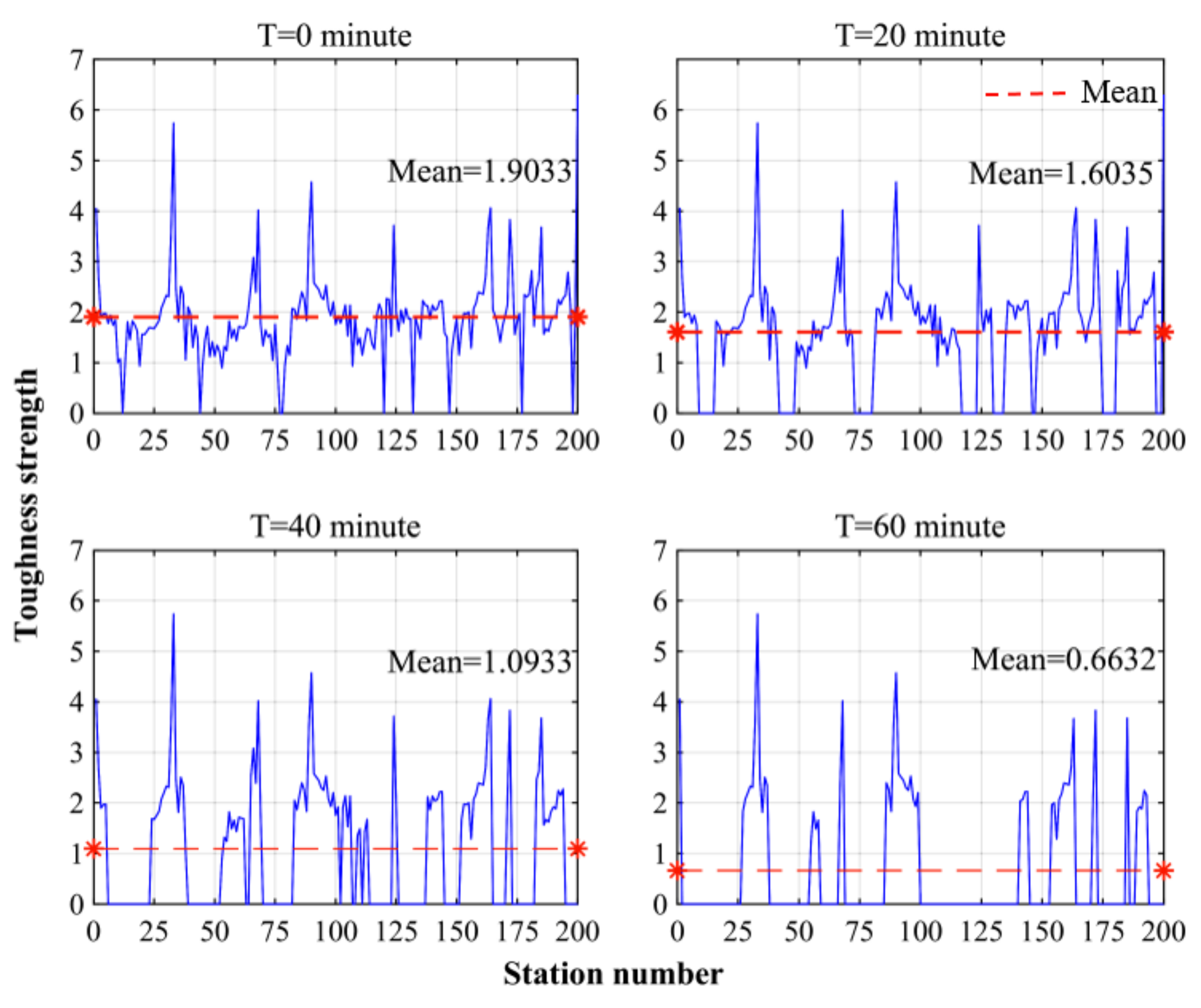
3.3.2. Node Toughness Strength Analysis
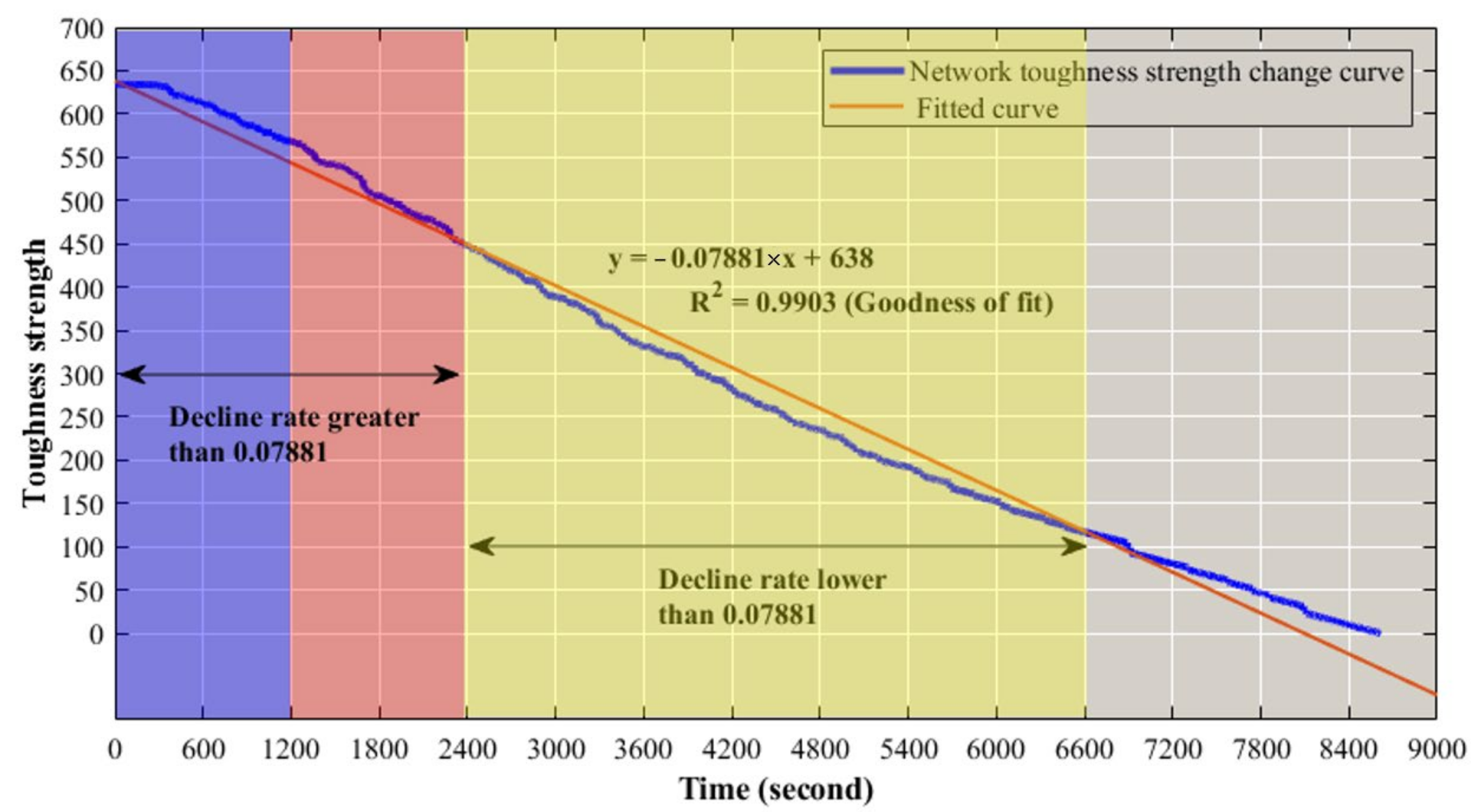
3.3.3. Toughness Strength Analysis of Network
3.3.4. Organization Recovery Capacity Evaluation
3.4. Resilience Enhancement Discussion of Metro Network
- Improve node toughness strength
- 2.
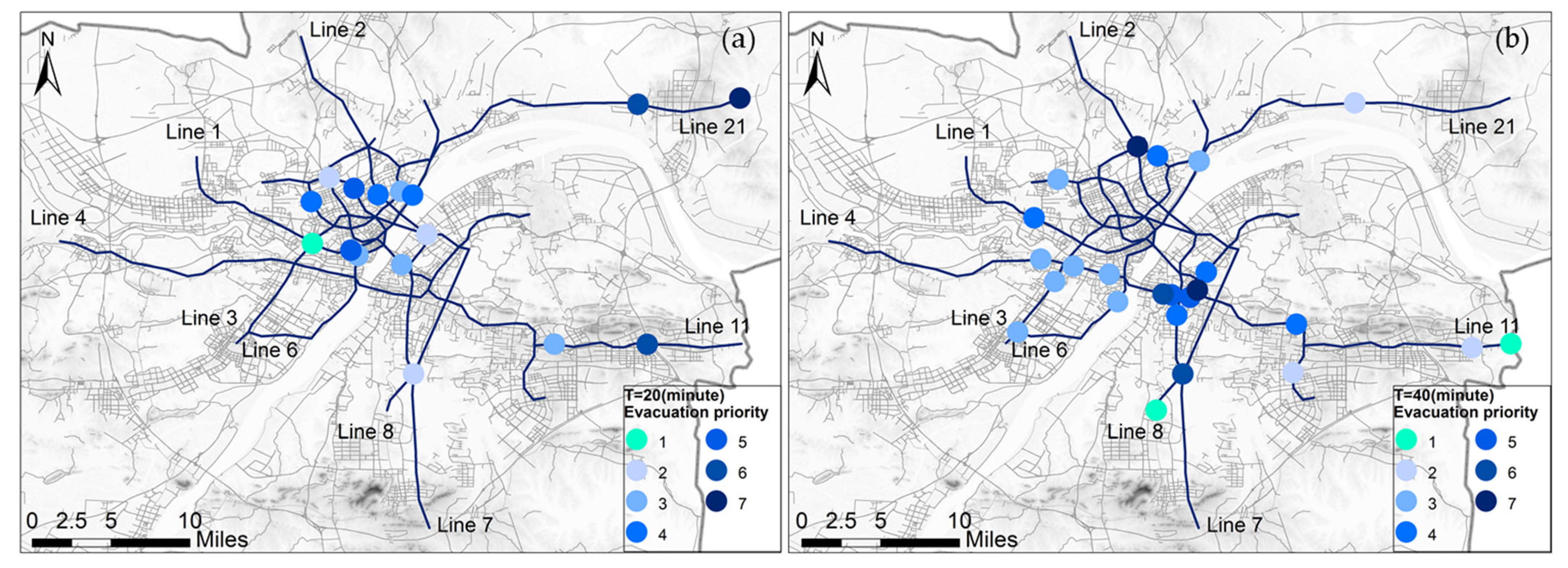
- Determine the priority of rescue and evacuation nodes
4. Conclusions
- The article establishes a simplified three-dimensional model of a complex metro network by topological methods while considering the slope directions between stations. The simplified dynamic network of metro nodes combines the topological characteristics of the metro system with the features of flood evolution. This paper presents research on urban metro flood risk from regional metro network resilience.
- The grid hydrodynamic is modeled to fully utilize high-precision DEM data for inundation prediction without preprocessing and meshing, significantly reducing processing time. This alternative model provides comparable results to conventional software for regional maximum flood extent, depth, and inundation duration. The grid hydrodynamic model perfectly identified the surface flood-prone points in this paper.
- The dynamic node breakdown algorithm was developed to obtain the subsurface flooding node sequence by inputting the node adjacency matrix and the distance between nodes. The principle of the algorithm is easy to understand. The calculation results are accurate and conform to the law of flood dispersion. The dynamic node breakdown algorithm finally obtains the whole metro network flooded process and the change of node toughness strength.
- The node toughness strength was estimated by combining the natural and social attributes of the nodes through the FBWM method. As a newer multi-criteria decision-making method, FBWM optimizes the minimum error by nonlinear programming equations and preserves the fuzzy information using fuzzy triangular numbers.
- Based on the above conclusions, the resilience of the Wuhan metro network was assessed. The rate of decline in the toughness strength of the metro network is higher than 0.079 and is maximum within the first 40 min. Organization recovery capacity during this period could reach 94.64%, achieving the rescue of most flooded nodes. In response to the evaluated resilience results, this paper proposes a resilience enhancement proposal based on improving the node toughness strength and determining the priority of rescue and evacuation nodes.
Author Contributions
Funding
Data Availability Statement
Acknowledgments
Conflicts of Interest
Appendix A
References
- Hapuarachchi, H.A.P.; Wang, Q.J.; Pagano, T.C. A review of advances in flash flood forecasting. Hydrol. Process. 2011, 25, 2771–2784. [Google Scholar] [CrossRef]
- Petit-Boix, A.; Sevigné-Itoiz, E.; Rojas-Gutierrez, L.A.; Barbassa, A.P.; Josa, A.; Rieradevall, J.; Gabarrell, X. Floods and consequential life cycle assessment: Integrating flood damage into the environmental assessment of stormwater Best Management Practices. J. Clean. Prod. 2017, 162, 601–608. [Google Scholar] [CrossRef] [Green Version]
- Global Assessment Report 2019. Geneva, Switzerland. Available online: https://www.undrr.org/publication/global-assessment-report-disaster-risk-reduction-2019 (accessed on 2 October 2021).
- Miller, J.D.; Hutchins, M. The impacts of urbanization and climate change on urban flooding and urban water quality: A review of the evidence concerning the United Kingdom. J. Hydrol. Reg. Stud. 2017, 12, 345–362. [Google Scholar] [CrossRef] [Green Version]
- Chan, F.K.S.; Griffiths, J.A.; Higgitt, D.; Xu, S.; Zhu, F.; Tang, Y.; Xu, Y.; Thorne, C.R. “Sponge City” in China—A breakthrough of planning and flood risk management in the urban context. Land Use Policy 2018, 76, 772–778. [Google Scholar] [CrossRef]
- Hallegatte, S.; Green, C.; Nicholls, R.J.; Corfee-Morlot, J. Future flood losses in major coastal cities. Nat. Clim. Chang. 2013, 3, 802–806. [Google Scholar] [CrossRef]
- Zhou, Q.; Mikkelsen, P.S.; Halsnæs, K.; Arnbjerg-Nielsen, K. Framework for economic pluvial flood risk assessment considering climate change effects and adaptation benefits. J. Hydrol. 2012, 414, 539–549. [Google Scholar] [CrossRef]
- U.N. World Urbanization Prospects: The 2018 Revision. 2018. Available online: https://www.un.org/development/desa/publications/2018-revision-of-world-urbanization-prospects.html (accessed on 10 October 2021).
- Pour, S.H.; Abd Wahab, A.K.; Shahid, S.; Asaduzzaman, M.; Dewan, A. Low impact development techniques to mitigate the impacts of climate-change-induced urban floods: Current trends, issues and challenges. Sustain. Cities Soc. 2020, 62, 102373. [Google Scholar] [CrossRef]
- Li, L.Y.; Uyttenhove, P.; Vaneetvelde, V. Planning green infrastructure to mitigate urban surface water flooding risk—A methodology to identify priority areas applied in the city of Ghent. Landsc. Urban Plan. 2020, 194, 103703. [Google Scholar] [CrossRef]
- Nguyen, T.T.; Ngo, H.H.; Guo, W.S.; Wang, X.C.C.; Ren, N.Q.; Li, G.B.; Ding, J.; Liang, H. Implementation of a specific urban water management—Sponge City. Sci. Total Environ. 2019, 652, 147–162. [Google Scholar] [CrossRef]
- UITP. World Metro Figures 2018. 2018. Available online: https://cms.uitp.org/wp/wp-content/uploads/2020/06/Statistics-Brief-World-metro-figures-2018V3_WEB.pdf (accessed on 11 October 2021).
- Lyu, H.; Zhou, W.; Shen, S.; Zhou, A. Inundation risk assessment of metro system using AHP and TFN-AHP in Shenzhen. Sustain. Cities Soc. 2020, 56, 102103. [Google Scholar] [CrossRef]
- Forero-Ortiz, E.; Martínez-Gomariz, E.; Cañas Porcuna, M. A review of flood impact assessment approaches for underground infrastructures in urban areas: A focus on transport systems. Hydrol. Sci. J. 2020, 65, 1943–1955. [Google Scholar] [CrossRef]
- Alfieri, L.; Feyen, L.; Dottori, F.; Bianchi, A. Ensemble flood risk assessment in Europe under high end climate scenarios. Glob. Environ. Chang. 2015, 35, 199–212. [Google Scholar] [CrossRef]
- Jongman, B.; Hochrainer-Stigler, S.; Feyen, L.; Aerts, J.C.; Mechler, R.; Botzen, W.J.; Bouwer, L.M.; Pflug, G.; Rojas, R.; Ward, P.J. Increasing stress on disaster-risk finance due to large floods. Nat. Clim. Chang. 2014, 4, 264–268. [Google Scholar] [CrossRef]
- Aerts, J.C.; Botzen, W.J.; Clarke, K.C.; Cutter, S.L.; Hall, J.W.; Merz, B.; Michel-Kerjan, E.; Mysiak, J.; Surminski, S.; Kunreuther, H. Integrating human behaviour dynamics into flood disaster risk assessment. Nat. Clim. Chang. 2018, 8, 193–199. [Google Scholar] [CrossRef] [Green Version]
- Lyu, H.M.; Shen, S.L.; Zhou, A.N.; Yang, J. Risk assessment of mega-city infrastructures related to land subsidence using improved trapezoidal FAHP. Sci. Total Environ. 2020, 717, 135310. [Google Scholar] [CrossRef]
- Lyu, H.; Sun, W.; Shen, S.; Arulrajah, A. Flood risk assessment in metro systems of mega-cities using a GIS-based modeling approach. Sci. Total Environ. 2018, 626, 1012–1025. [Google Scholar] [CrossRef]
- Wang, G.; Liu, Y.; Hu, Z.; Zhang, G.; Liu, J.; Lyu, Y.; Gu, Y.; Huang, X.; Zhang, Q.; Liu, L. Flood Risk Assessment of Subway Systems in Metropolitan Areas under Land Subsidence Scenario: A Case Study of Beijing. Remote Sens. 2021, 13, 637. [Google Scholar] [CrossRef]
- Yin, J.; Yu, D.P.; Yin, Z.; Liu, M.; He, Q. Evaluating the impact and risk of pluvial flash flood on intra-urban road network: A case study in the city center of Shanghai, China. J. Hydrol. 2016, 537, 138–145. [Google Scholar] [CrossRef] [Green Version]
- Suarez, P.; Anderson, W.; Mahal, V.; Lakshmanan, T.R. Impacts of flooding and climate change on urban transportation: A systemwide performance assessment of the Boston Metro Area. Transp. Res. Part D Transp. Environ. 2005, 10, 231–244. [Google Scholar] [CrossRef]
- Von Ferber, C.; Holovatch, T.; Holovatch, Y.; Palchykov, V. Public transport networks: Empirical analysis and modeling. Eur. Phys. J. B 2009, 68, 261–275. [Google Scholar] [CrossRef] [Green Version]
- Derrible, S.; Kennedy, C. The complexity and robustness of metro networks. Phys. A 2010, 389, 3678–3691. [Google Scholar] [CrossRef]
- Zhang, D.; Du, F.; Huang, H.; Zhang, F.; Ayyub, B.M.; Beer, M. Resiliency assessment of urban rail transit networks: Shanghai metro as an example. Saf. Sci. 2018, 106, 230–243. [Google Scholar] [CrossRef]
- Zhang, J.; Wang, Z.; Wang, S.; Shao, W.; Zhao, X.; Liu, W. Vulnerability assessments of weighted urban rail transit networks with integrated coupled map lattices. Reliab. Eng. Syst. Saf. 2021, 214, 107707. [Google Scholar] [CrossRef]
- Wu, X.T.; Dong, H.R.; Tse, C.K.; Ho, I.W.H.; Lau, F.C.M. Analysis of metro network performance from a complex network perspective. Phys. A 2018, 492, 553–563. [Google Scholar] [CrossRef]
- Gao, B.; Qin, Y.; Xiao, X.; Zhu, L. K-means Clustering Analysis of Key Nodes and Edges in Beijing Subway Network. J. Transp. Syst. Eng. Inf. Technol. 2014, 14, 207–213. [Google Scholar]
- Yao, L.; Sun, L.; Wang, W.; Xia, X. Connection Facility Layout Model of Subway Stations. Adv. Mech. Eng. 2015, 7, 457508. [Google Scholar] [CrossRef]
- Kurant, M.; Thiran, P. Extraction and analysis of traffic and topologies of transportation networks. Phys. Rev. E 2006, 74, 036114. [Google Scholar] [CrossRef] [Green Version]
- Yinghua, S.; Yuzhi, L.; Feizhou, H.; Yiyun, M. Vulnerability of Two-layer Traffic Network of Bus and Subway under Waterlogging Condition Based on Complex Network Theory. Saf. Environ. Eng. 2021, 28, 114–120. [Google Scholar]
- Zou, Q.; Zhou, J.; Zhou, C.; Song, L.; Guo, J. Comprehensive flood risk assessment based on set pair analysis-variable fuzzy sets model and fuzzy AHP. Stoch. Environ. Res. Risk Assess. 2013, 27, 525–546. [Google Scholar] [CrossRef]
- Gai, L.; Nunes, J.P.; Baartman, J.E.M.; Zhang, H.; Wang, F.; de Roo, A.; Ritsema, C.J.; Geissen, V. Assessing the impact of human interventions on floods and low flows in the Wei River Basin in China using the LISFLOOD model. Sci. Total Environ. 2019, 653, 1077–1094. [Google Scholar] [CrossRef]
- Anderson, M.; Kavvas, M.; Mierzwa, M. Developing probabilistic representations of climatic influences on hydrological response using a coupled hydrological-atmospheric model. Hydrolog. Sci. J. 2003, 48, 693–708. [Google Scholar] [CrossRef] [Green Version]
- Dottori, F.; Martina, M.L.V.; Figueiredo, R. A methodology for flood susceptibility and vulnerability analysis in complex flood scenarios. J. Flood Risk Manag. 2018, 11, S632–S645. [Google Scholar] [CrossRef]
- MIKE 21-2D Modelling of Coast and Sea. Available online: https://www.mikepoweredbydhi.com/areas-of-application/coast-and-sea (accessed on 18 October 2021).
- Evaluation of Inundation Models. Available online: https://xueshu.baidu.com/usercenter/paper/show?paperid=1b23e91716eed7b35c353be76309e5ae&site=xueshu_se (accessed on 21 October 2021).
- Benchmarking of 2D Hydraulic Modelling Packages. Available online: https://www.researchgate.net/publication/257343214_Benchmarking_of_2D_Hydraulic_Modelling_Packages (accessed on 21 October 2021).
- Teng, J.; Jakeman, A.J.; Vaze, J.; Croke, B.F.W.; Dutta, D.; Kim, S. Flood inundation modelling: A review of methods, recent advances and uncertainty analysis. Environ. Modell. Softw. 2017, 90, 201–216. [Google Scholar] [CrossRef]
- Wilson, M.; Bates, P.; Alsdorf, D.; Forsberg, B.; Horritt, M.; Melack, J.; Frappart, F.; Famiglietti, J. Modeling large-scale inundation of Amazonian seasonally flooded wetlands. Geophys. Res. Lett. 2007, 34, L15404. [Google Scholar]
- Zheng, Y.Z.; Sun, H. An Integrated Approach for the Simulation Modeling and Risk Assessment of Coastal Flooding. Water 2020, 12, 2076. [Google Scholar] [CrossRef]
- Ishigaki, T.; Toda, K.; Inoue, K. Hydraulic model tests of inundation in urban area with underground space. In Proceedings of the 30th IAHR Congress, Thessaloniki, Greece, 24–29 August 2003; pp. 487–493. [Google Scholar]
- Toda, K.; Kawaike, K.; Yoneyama, N.; Fukakusa, S.; Yamamoto, D. Underground Inundation Analysis by Integrated Urban Flood Model. In Advances in Water Resources and Hydraulic Engineering; Zhang, C.K., Tang, H.W., Eds.; Springer: Nanjing, China, 2009; Volume 1–6, pp. 166–171. [Google Scholar]
- Yoneyama, N.; Toda, K.; Aihata, S.; Yamamoto, D. Numerical Analysis for Evacuation Possibility from Small Underground Space in Urban Flood. In Advances in Water Resources and Hydraulic Engineering; Zhang, C.K., Tang, H.W., Eds.; Springer: Nanjing, China, 2009; Volume 1–6, pp. 107–112. [Google Scholar]
- Wu, J.S.; Li, N.; Liu, W.Y.; Zhou, S.L. Numerical modeling of flooding current flow over the underground complex staircases with a GPU-based SPH method. J. Saf. Environ. 2019, 19, 774–779. [Google Scholar]
- Forero-Ortiz, E.; Martinez-Gomariz, E.; Porcuna, M.C.; Locatelli, L.; Russo, B. Flood Risk Assessment in an Underground Railway System under the Impact of Climate Change—A Case Study of the Barcelona Metro. Sustainability 2020, 12, 5291. [Google Scholar] [CrossRef]
- Shao, W. Critical rainfall intensity for safe evacuation from underground spaces with flood prevention measures. J. Zhejiang Univ-Sci. A 2010, 11, 668–676. [Google Scholar] [CrossRef]
- Wu, J.S.; Shengdi, X.; Hui, Z. A review of experimental and numerical simulation studies on flooding in urban underground spaces. China Saf. Sci. J. 2016, 26, 1–6. [Google Scholar]
- Wu, J.; Fang, W.; Hu, Z.; Hong, B. Application of Bayesian Approach to Dynamic Assessment of Flood in Urban Underground Spaces. Water 2018, 10, 1112. [Google Scholar] [CrossRef] [Green Version]
- Son, A.; Kim, B.; Han, K. A Simple and Robust Method for Simultaneous Consideration of Overland and Underground Space in Urban Flood Modeling. Water 2016, 8, 494. [Google Scholar] [CrossRef] [Green Version]
- Han, Y.; Shin, E.T.; Eum, T.S.; Song, C.G. Inundation Risk Assessment of Underground Space Using Consequence-Probability Matrix. Appl. Sci. 2019, 9, 1196. [Google Scholar] [CrossRef] [Green Version]
- Kazakis, N.; Kougias, I.; Patsialis, T. Assessment of flood hazard areas at a regional scale using an index-based approach and Analytical Hierarchy Process: Application in Rhodope-Evros region, Greece. Sci. Total Environ. 2015, 538, 555–563. [Google Scholar] [CrossRef]
- Lyu, H.; Shen, S.; Zhou, A.; Zhou, W. Flood risk assessment of metro systems in a subsiding environment using the interval FAHP-FCA approach. Sustain. Cities Soc. 2019, 50, 101682. [Google Scholar] [CrossRef]
- Xu, H.; Ma, C.; Lian, J.; Xu, K.; Chaima, E. Urban flooding risk assessment based on an integrated k-means cluster algorithm and improved entropy weight method in the region of Haikou, China. J. Hydrol. 2018, 563, 975–986. [Google Scholar] [CrossRef]
- Yang, W.; Xu, K.; Lian, J.; Ma, C.; Bin, L. Integrated flood vulnerability assessment approach based on TOPSIS and Shannon entropy methods. Ecol. Indic. 2018, 89, 269–280. [Google Scholar] [CrossRef]
- Zhao, Y.; Gong, Z.; Wang, W.; Luo, K. The comprehensive risk evaluation on rainstorm and flood disaster losses in China mainland from 2004 to 2009: Based on the triangular gray correlation theory. Nat. Hazards. 2014, 71, 1001–1016. [Google Scholar] [CrossRef]
- Guo, S.; Zhao, H. Fuzzy best-worst multi-criteria decision-making method and its applications. Knowl.-Based Syst. 2017, 121, 23–31. [Google Scholar] [CrossRef]
- Rezaei, J. Best-worst multi-criteria decision-making method. Omega 2015, 53, 49–57. [Google Scholar] [CrossRef]
- Kourgialas, N.N.; Karatzas, G.P. A national scale flood hazard mapping methodology: The case of Greece—Protection and adaptation policy approaches. Sci. Total Environ. 2017, 601, 441–452. [Google Scholar] [CrossRef]
- Tehrany, M.S.; Pradhan, B.; Mansor, S.; Ahmad, N. Flood susceptibility assessment using GIS-based support vector machine model with different kernel types. Catena 2015, 125, 91–101. [Google Scholar] [CrossRef]
- Wang, Z.; Lai, C.; Chen, X.; Yang, B.; Zhao, S.; Bai, X. Flood hazard risk assessment model based on random forest. J. Hydrol. 2015, 527, 1130–1141. [Google Scholar] [CrossRef]
- Du, Z.; Tang, J.; Qi, Y.; Wang, Y.; Han, C.; Yang, Y. Identifying critical nodes in metro network considering topological potential: A case study in Shenzhen City-China. Phys. A 2020, 539, 122926. [Google Scholar] [CrossRef]
- Wuhan Local Standards DB4201/T 641 2020. Wuhan, China. Available online: https://max.book118.com/html/2021/0123/7116125135003045.shtm (accessed on 6 February 2022).


| Difference of Terrain (m) | Weights from Low to High Terrain Nodes | Weights from High to Low Terrain Nodes |
|---|---|---|
| 0–6 | 0.5 | 0.6 |
| 6–12 | 0.4 | 0.7 |
| 12–18 | 0.3 | 0.8 |
| 18–24 | 0.2 | 0.9 |
| 24–30 | 0.1 | 1 |
| Linguistic Terms | Membership Function (L,M,N) |
|---|---|
| Equally important (EI) | (1,1,1) |
| Weakly important (WI) | (2/3,1,3/2) |
| Fairly important (FI) | (3/2,2,5/2) |
| Very important (VI) | (5/2,3,7/2) |
| Absolutely important (AI) | (7/2,4,9/2) |
| Data | Source |
|---|---|
| Remote-sensing data | http://eds.ceode.ac.cn/nuds/freedataquery (accessed on 15 December 2021) |
| DEM (30 m × 30 m) | http://www.gscloud.cn (accessed on 20 November 2021) |
| Design Formula of Rainstorm Intensity | Wuhan local standards DB4201/T 641 2020 (accessed on 6 December 2021) |
| Metro passenger flow in Wuhan | https://iwuhan.org/webapps/WuhanMetroFlowDetail/ (accessed on 12 January 2022) |
| GDP density | http://tjj.hubei.gov.cn/tjsj/ (accessed on 15 December 2021) |
| Number of metro stations | https://www.wuhanrt.com/public_forward.aspx (accessed on 15 December 2021) |
| Distance between metro stations | https://www.wuhanrt.com/public_forward.aspx (accessed on 7 November 2021) |
| Elevation within the metro network. | https://www.wuhanrt.com/public_forward.aspx (accessed on 7 January 2022) Fieldwork estimation(Estimated from subway floors) |
| Indicators\Category | The Ability to Receive Flood (25%) | The Ability to Transmit Flood (25%) | The Risk of Casualties (20%) | The Risk of Economic Loss (20%) | The Importance of Location (10%) | Best Indicators/Bj |
|---|---|---|---|---|---|---|
| Node degree | 25% | 25% | - | - | - | EI |
| Node strength | - | 25% | - | - | - | FI |
| Node betweenness | 20% | 20% | - | - | WI | |
| Closeness centrality | - | - | - | - | 10% | AI |
| Passenger flow | - | - | 20% | - | - | VI |
| GDP density | - | - | - | 20% | - | VI |
| Indicators | Fuzzy Weight | Comprehensive Weight |
|---|---|---|
| Node degree | (0.3046, 0.3088, 0.3489) | 0.3148 |
| Node strength | (0.1420, 0.1420, 0.1829) | 0.1488 |
| Node betweenness | (0.2382, 0.2382, 0.3152) | 0.2510 |
| Closeness centrality | (0.0830, 0.0834, 0.0951) | 0.0853 |
| Passenger flow | (0.0919, 0.1051, 0.1130) | 0.1042 |
| GDP density | (0.0919, 0.1051, 0.1130) | 0.1042 |
Publisher’s Note: MDPI stays neutral with regard to jurisdictional claims in published maps and institutional affiliations. |
© 2022 by the authors. Licensee MDPI, Basel, Switzerland. This article is an open access article distributed under the terms and conditions of the Creative Commons Attribution (CC BY) license (https://creativecommons.org/licenses/by/4.0/).
Share and Cite
Sun, H.; Li, M.; Jiang, H.; Ruan, X.; Shou, W. Inundation Resilience Analysis of Metro-Network from a Complex System Perspective Using the Grid Hydrodynamic Model and FBWM Approach: A Case Study of Wuhan. Remote Sens. 2022, 14, 3451. https://doi.org/10.3390/rs14143451
Sun H, Li M, Jiang H, Ruan X, Shou W. Inundation Resilience Analysis of Metro-Network from a Complex System Perspective Using the Grid Hydrodynamic Model and FBWM Approach: A Case Study of Wuhan. Remote Sensing. 2022; 14(14):3451. https://doi.org/10.3390/rs14143451
Chicago/Turabian StyleSun, Hai, Meixin Li, Hui Jiang, Xuejing Ruan, and Wenchi Shou. 2022. "Inundation Resilience Analysis of Metro-Network from a Complex System Perspective Using the Grid Hydrodynamic Model and FBWM Approach: A Case Study of Wuhan" Remote Sensing 14, no. 14: 3451. https://doi.org/10.3390/rs14143451