Article

Hydrological Characteristics Change of Hala Lake and Its Response to Climate Change, 1987–2018

1
College of Earth and Environmental Sciences, Lanzhou University, Lanzhou 730000, China
2
Innovation Academy for Precision Measurement Science and Technology, Chinese Academy of Sciences, Wuhan 430077, China
3
Key Laboratory of Geological Survey and Evaluation of Ministry of Education, China University of Geosciences (Wuhan), Wuhan 430074, China
4
Faculty of Geographical Sciences, Yunnan Normal University, Kunming 650000, China
5
Technology and Innovation Centre for Environmental Geology and Geohazards Prevention, School of Earth Sciences, Lanzhou University, Lanzhou 730000, China
*
Author to whom correspondence should be addressed.
Remote Sens. 2022, 14(12), 2886; https://doi.org/10.3390/rs14122886
Submission received: 30 March 2022 / Revised: 20 May 2022 / Accepted: 10 June 2022 / Published: 16 June 2022
(This article belongs to the Topic Cryosphere: Changes, Impacts and Adaptation)

Abstract

:
Lakes on the Tibetan Plateau (TP) are an indicator of global climate change. The study on the factors driving lake change on the TP can help us understand its response to climate change. In this study, Landsat and ICESat data were used to obtain the variations of area, water level, and storage of Hala Lake and the area of glaciers in the Hala Lake Basin during 1987–2018. Combined with meteorological data, climate change trends and the factors driving Hala Lake change in the last 30 years were analyzed. The contribution of glacier mass loss to lake recharge was estimated by the water balance of Hala Lake. The results showed that Hala Lake has experienced three stages: slight expansion (1987–1994), shrinkage (1995–2001) and rapid expansion (2002–2018) during the study period. The rate of glacial melting continued to decline during the study period. Precipitation was the main factor that drove the hydrological characteristic changes in Hala Lake. The step change points of annual precipitation and temperature occurred in 2001, almost the same time that Hala Lake began expanding rapidly.

1. Introduction

The Tibetan Plateau (TP), the highest and largest plateau in the world, is an amplifier of climate change. From 1982 to 2012, the average temperature rise on the TP was twice the global average [1]. There are many glaciers and lakes on the TP, which is called the Water Tower of Asia [2]. Lakes on the TP are highly sensitive to global changes due to their high altitude and low impact from human activities [3,4]. They are not only affected by precipitation and evaporation, but also by glacier retreat and permafrost degradation caused by temperature rise [5]. Therefore, it is necessary to understand lake dynamics and their relationship with climate change on the TP.
At present, the research on lakes on the TP focuses on examining the changes in lake area [6], level [7,8,9,10] and storage [11,12,13] based on field measurements and remote sensing data. In recent decades, lakes on the TP have generally expanded [12,13,14,15], except for lakes located in the southeastern TP [16,17,18,19]. The number and total area of lakes on the TP have also increased [20]. Lakes on the TP expanded faster than at other times during 2003–2009 [8,11].
The cause of the expansion of the lakes on the TP is a matter of debate. Zhu and Wu’s research showed that the main reason for the expansion of Nam Co Lake was increased glacier meltwater caused by rising temperatures during 1992–2004 [21]. Glacial meltwater contributes about half of the increased water storage in glacier-fed lakes in the Tanggula Mountains [22] and the northwestern part of the TP [23]. Li et al. found that the lakes in the continuous permafrost region expanded, while the glacier-fed lakes either remained stable or shrank in the isolated permafrost region; they believed that the permafrost degradation was greater than the impact of glacial melting on the lakes [14]. There was some research showing that increased precipitation on the TP is the main reason for the lakes’ expansion in recent decades [10,16,24,25]. The results simulated by hydrological models also indicate that the expansion of Selin co Lake [26] and lakes in the central and southern TP [27] is caused by the increase in precipitation. Evaporation decreased [28] with dropping wind speeds on the TP [29,30]. The 4% increase in the water level of Nam Co Lake was caused by the reduction of lake evaporation during the period 1998–2008 [31].
Climate patterns over the TP are influenced by westerlies, Indian monsoon and East Asian monsoon [32,33,34]. Hala Lake, which is fed by glaciers and in an area with almost no human activity, is an ideal area to study the response of lakes to climate change because it is located in the transition region of the East Asian monsoon, Indian monsoon and the westerlies and is very sensitive to climate change [35].
In this study, remote sensing data was used to extract the area and water level of Hala Lake and the glacier area of Hala Lake Basin from 1987 to 2018. Changes in Hala Lake’s water storage were calculated from the area and the water level. Combined with meteorological data, the factors driving change at Hala Lake were analyzed to understand the impact of climate change on the lake during 1987–2018. The change in the area of Hala Lake in 31 recent years can be divided into three stages: slight expansion (1987–1994), shrinkage (1995–2001) and rapid expansion (2002–2018). Therefore, in this study, we analyzed the driving factors of hydrological characteristics change during these three phases.

2. Materials and Methods
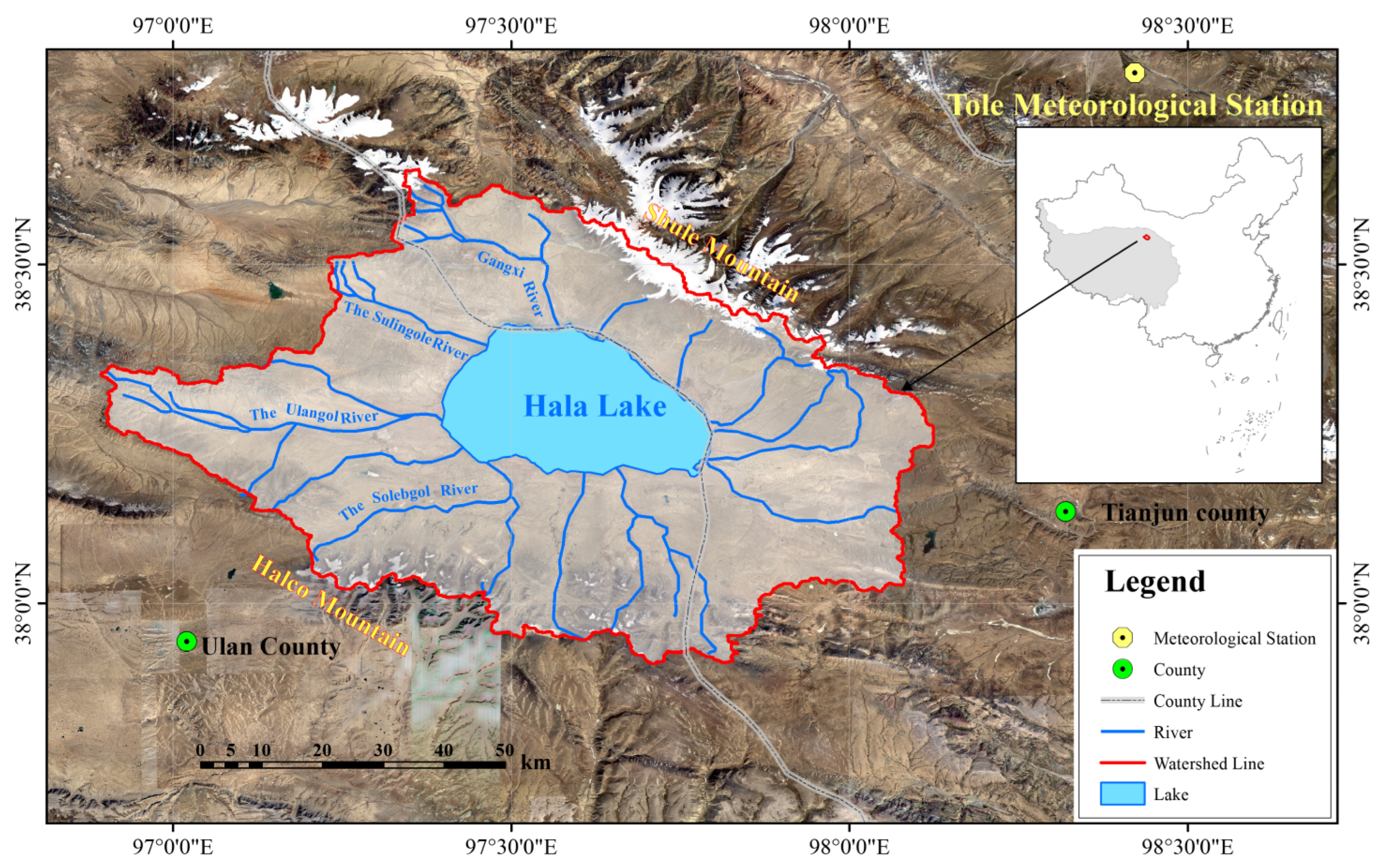
2.1. Study Area

Hala Lake Basin is located in the Qilian Mountains in the north of the TP, with the Basin area of 4793   km 2 (Figure 1). Hala Lake is a closed saline lake with an altitude of about 4078   m . The average depth and maximum depth of Hala Lake is 27.14   m and 65   m , respectively. The water storage is about 161 × 10 8   m 3 . There are more than 40 short rivers with small flows and 118 glaciers that feed into Hala Lake. The climate in the Hala Lake Basin is dry and cold.

2.2. Estimating Lake Water Storage Change and the Uncertainty

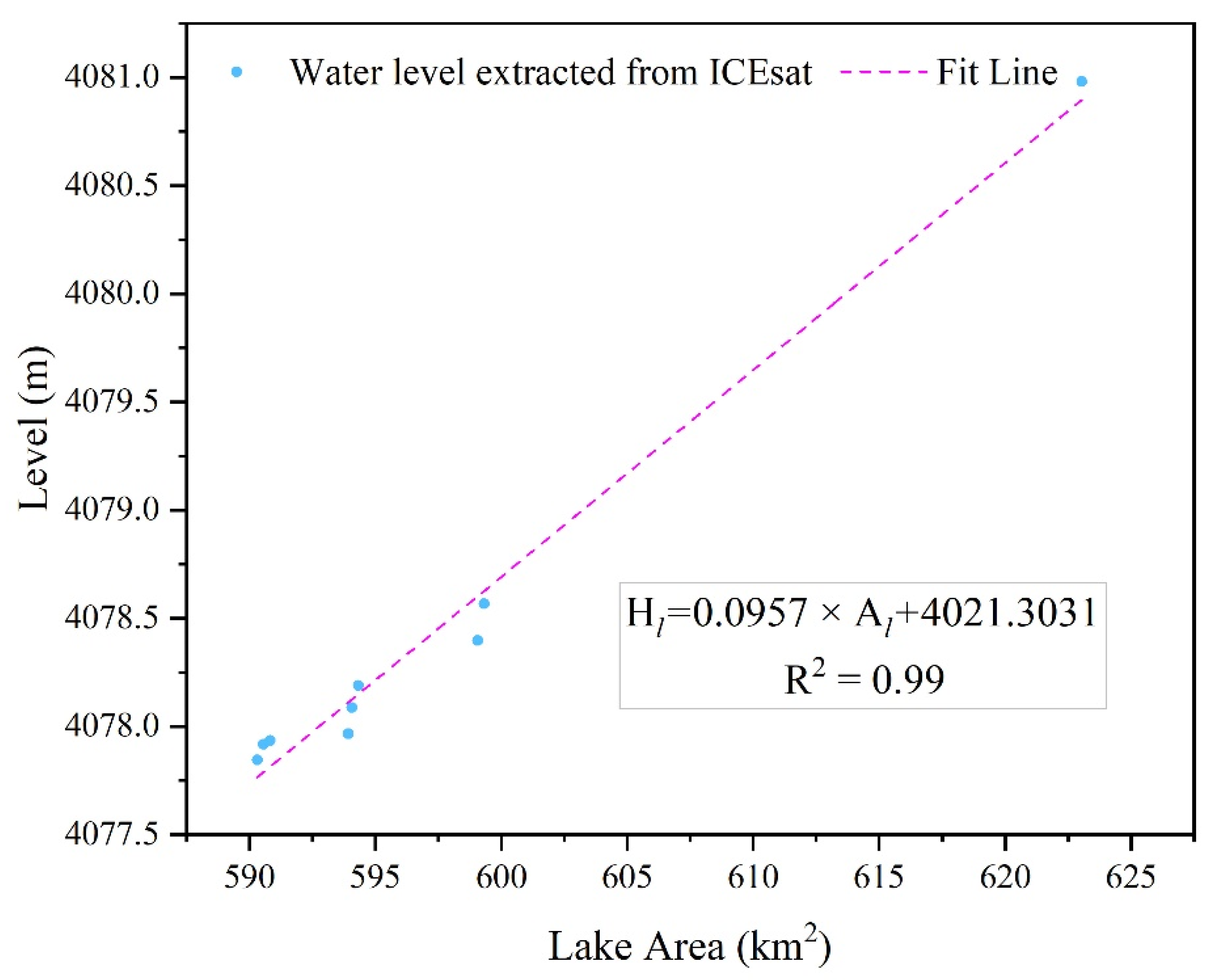
2.2.1. Lake Water Storage Change Estimate

In this study, Landsat surface reflection data in Google Earth Engine (GEE) were used to extract the area of Hala Lake during 1987–2018. Only cloud-free images acquired from August to September every year were selected to avoid cloud pollution and exclude periods of lake freezing. The normalized water index algorithm(NDWI) [36] which has the highest accuracy in extracting the area of lakes on the TP [37] was used to determine the extent of Hala Lake. All the Landsat images were processed using cloud computing technology based on the GEE platform. The interannual variation of water area was estimated using the average lake area during August to September each year.
The ICESat1 data (https://search.earthdata.nasa.gov, accessed 18 December 2018) and ICESat2 data (https://nsidc.org/data/, accessed 17 June 2021) was used to extract the water level of Hala Lake from 2003 to 2009 and 2018 because elevation estimates from ICESat1 and ICESat2 are much more precise compared to those from radar altimetry [38,39,40]. The water level data was converted from ellipsoidal heights of WGS84 to orthometric heights of EGM2008. The level-surface area relationship curve (LRC) method correlated the water surface area with the water level data to fit the water level-area curve [41]. The LRC could be used to estimate the water level with area as the input. In this study, the LRC was constructed by the area and level of Hala Lake obtained from Landsat and ICESat data which acquired time closest:
H l = 0.0957 × A l + 4021.3031   R 2 = 0.99
where H l is the water level ( m ) and A l is the water area ( km 2 ).
The water levels, which cannot be extracted from ICESat data, can be estimated by LRC (Figure 2) according to corresponding water areas. The following formula was used to estimate the change of water storage of Hala Lake between different years i and j :
  d V l i , j = d H l i , j × A l i + A l i A l j + A l j / 3
where A l i   m 2   and   A l j   m 2 are the lake water areas in the year i and j and d H l i , j   m and d V l i , j   m 3 are the changes in lake water levels and storage separately between year i and j .

2.2.2. Uncertainty of Lake Water Storage Change

To obtain the LRC curve, two sets of water level-area data are sufficient, and other sets of observations are redundant. The mean square error σ w l of water level estimated by LRC can be calculated by the equation below:
σ w l = V T V r  
where V is an error vector of water levels used to construct LRC, and r is the number of redundant observations. In this study, the σ w l is ±   0.13   m . The median error of the difference between two water levels can be estimated using the following equation:
σ d H l i , j = 2 σ w l
The difference between the area of Hala Lake abstracted by visual interpretation of a Sentinel-2 image (13 July 2018) and the result of a Landsat8 image (17 July 2018) abstracted by normalized water index algorithm is 2.59   km 2 . Assuming that the difference above is the median error of the lake area, the relative error is only 0.4%. The median error of Hala Lake area A l i in the i can be calculated by a formula as follows:
σ A l i = 0.4 % × A l i
Based on the nonlinear error propagation law and Equation (2), the median error of d V l i , j can be calculated by the following formula:
σ d V l i , j = 1 3 A l i + A l i A l j + A l j σ d H l i , j 2 + d H l i , j + d H l i , j A l j 2 A l i A l j 2 σ A l i 2 + d H l i , j + d H l i , j A l j 2 A l i A l j 2 σ A l j 2
The uncertainty of lake water storage change is given in 1 sigma confidence level. The lake level estimation is the primary source of error of the lake water storage change estimation according to Equation (6). The σ d V l 1987 , 1994 is larger than d V l 1987 , 1994 because Hala Lake was relatively stable during 1987–1994. The relative error of d V l 1995 , 2001 and d V l 2002 , 2018 as percentages were estimated to be 18.9 % and 5 % , respectively.

2.3. Estimating Glacier Mass Loss and the Uncertainty

2.3.1. Glacier Area Extraction and Glacier Mass Loss Estimation

The seasonal snowfall may occur in all seasons except summer in the Hala Lake Basin. To avoid seasonal snowfall, Landsat images taken on cloudless days from July to September each year were selected to map the glacier extents using thresholded ratio images RED/SWIR(TM3/TM5) [42,43,44] in this study. Holes on the glacier map smaller than 0.05   km 2 which were probably caused by rock debris were repaired by a morphological reconstruction operation [45]. Only glaciers larger than 0.05   km 2 were mapped because a smaller area criterion would likely include many snow patches [46].
Landsat images obtained in 1990, 1995, 1999, 2002, 2006, 2010, 2013 and 2018 meet the requirements above and can be used to extract glaciers in the Hala Lake Basin. The glacier area of other years during the study period were obtained by interpolation. There was no data about the glaciers during 1987–1990 in the Hala Lake Basin; the annual change in the glacial area from 1987 to 1990 was thought to be the same as during 1990–1995.
The glacier volume–area relation can be used to estimate glacier volume change by the change of glacier area [47,48,49,50]. In this study, an empirical formula of glacier volume–area established by Liu [51] was used to estimate the glacier volume in the Hala Lake Basin:
V G = 0.04 × A G 1.35
where V G and A G are glacier volume ( km 3 ) and area ( km 2 ), respectively. The glacier volume change can be estimated by the following equation:
Δ V G i , j = V G i V G j
where V G i and V G j are glacier volume in different years i   and j . In this study, we suppose an average glacier density of 850   kg · m 3 [52], and glacier mass loss G l was fully converted into lake water when we estimated the impact of glaciers on Hala Lake. The lake water converted by glacier mass loss G l i , j during i j years can be calculated by the following equation:
G l i , j = 0.85 × Δ V G i , j

2.3.2. Uncertainty of Glacier Mass Loss

The glacier area error can be estimated by the following equation [53]:
ε = N A h p
where ε   m 2 is the error of glacier area, N is the number of pixels on the edge of the glacier and A h p   m 2 is the area of the ground corresponding to half a pixel. Assuming that the ε is the median error of glacier area σ A G , the relative error r G i can be calculated by the ratio of the median error σ A G i to the glacier area A G i   m 2 in the i year. In this study, only the relative error of 1990, 1995, 1999, 2002, 2006, 2010, 2013 and 2018 can be obtained. The relative errors of the other years during the study period are replaced by the average of the relative errors 4.45 % of the eight years. The median error of glacier area A G i can be calculated by a formula as follows:
σ A G i = r G i A G i
The equation that follows can estimate the median error of glacier volume σ V G :
σ V G = 0.054 σ A G 0.35
The median error of glacier volume change between different years i and j can be estimated by an equation as follows:
σ Δ V G i , j = σ V G i 2 + σ V G j 2
The median error of glacier mass loss σ G l i , j is calculated based on σ Δ V G i , j :
σ G l i , j = 0.85 σ Δ V G i , j
The uncertainty of glacier mass loss is also given in 1 sigma confidence level. The glacier area estimation is the primary source of error of the glacier mass loss estimation in this study. The relative error of G l 1987 , 1994 , G l 1995 , 2001 and G l 2002 , 2018 as percentages were estimated to be 5.72 % , 11.88 % and 5.43 % , respectively.

2.4. Water Balance

Hala Lake Basin is an endorheic Basin, and its water budget can be expressed by the following equation:
d V = R + P   w E w
where d V is the storage change of Hala Lake. Hala Lake is supplied mainly by runoff R and precipitation on the lake surface P w . Runoff R includes groundwater exchange and surface runoff caused by land surface precipitation, permafrost thawing and glacial meltwater. The water level of Hala Lake is affected by lake surface evaporation E w . P   w and E w can be calculated as the following equation:
P w = P r e c i p i t a t i o n × A l a k e
E w = E × K × A l a k e
where A l a k e is the area of Hala Lake. The datasets of monthly 0.5 ° × 0.5 ° grid-based precipitation and temperature over China, which were generated by spatial interpolation based on data of 2472 meteorological stations in China, provided by the China Meteorological Data Service Centre (https://data.cma.cn), were used to estimate the precipitation and temperature in the Hala Lake Basin. In this study, the pan evaporation E   ( mm ) from the nearest meteorological station (Tole Meteorological Station (Figure 1)) to the Hala Lake Basin were used to estimate lake surface evaporation, and K is a conversion coefficient between the evaporation pan and the evaporation of the lake surface. Two kinds of evaporation pans of ∅ 20 and E-601B were used in the Tole Meteorological Station, with conversion coefficients of K 20 = 0.60 and K E 601 B = 0.68 , respectively [54,55].

2.5. Statistical Methods

The method of the non-parametric Mann–Kendall statistical test [56,57,58] can be used to extract step change points [37,59,60] and trends [61,62] in time series of climate parameters. For a given time series x 1 , x 2 , x n :
m i = j = 1 i f x i x j   1 i n
where   f x can be defined as the following:
f x = 1 ,         x > 0 0 ,         x 0
Under the null hypothesis (no step change points), The normal distribution statistic t k can be described as follows:
t k = i = 1 k m i   1 k n
The mean E t k and variance D t k of t k can be defined as follows:
E t k = k k 1 / 4 D t k = k k 1 2 k + 5 / 72
U F k is the normalized variable statistic of t k , and the formula is as follows:
U F k = t k E t k / D t k
All U F k 1 k n can form a curve U F . The time series x 1 , x 2 , x n has an increasing trend when U F k > 0 ; otherwise, it has a decreasing trend. The curve U B can be obtained by the above method to process the opposite time series x n , x n 1 , x 1 . The intersection of curve U F and U B represents the time of the step change point.
In addition, linear regression analysis and Poisson correlation analysis were used to analyze the trend of time series data and the relationship between Hala Lake water storage change and climate factors in this study.

3. Results

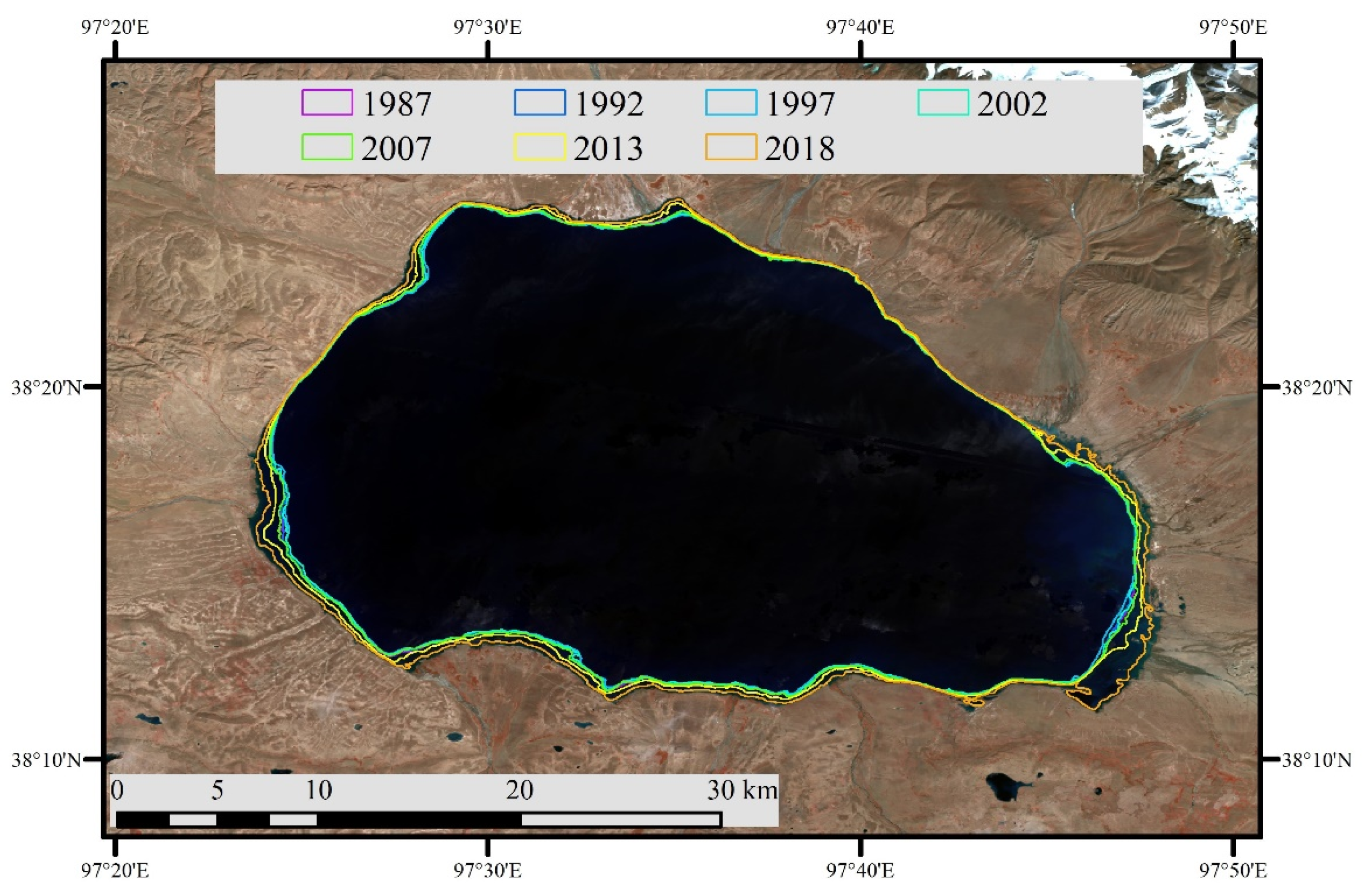
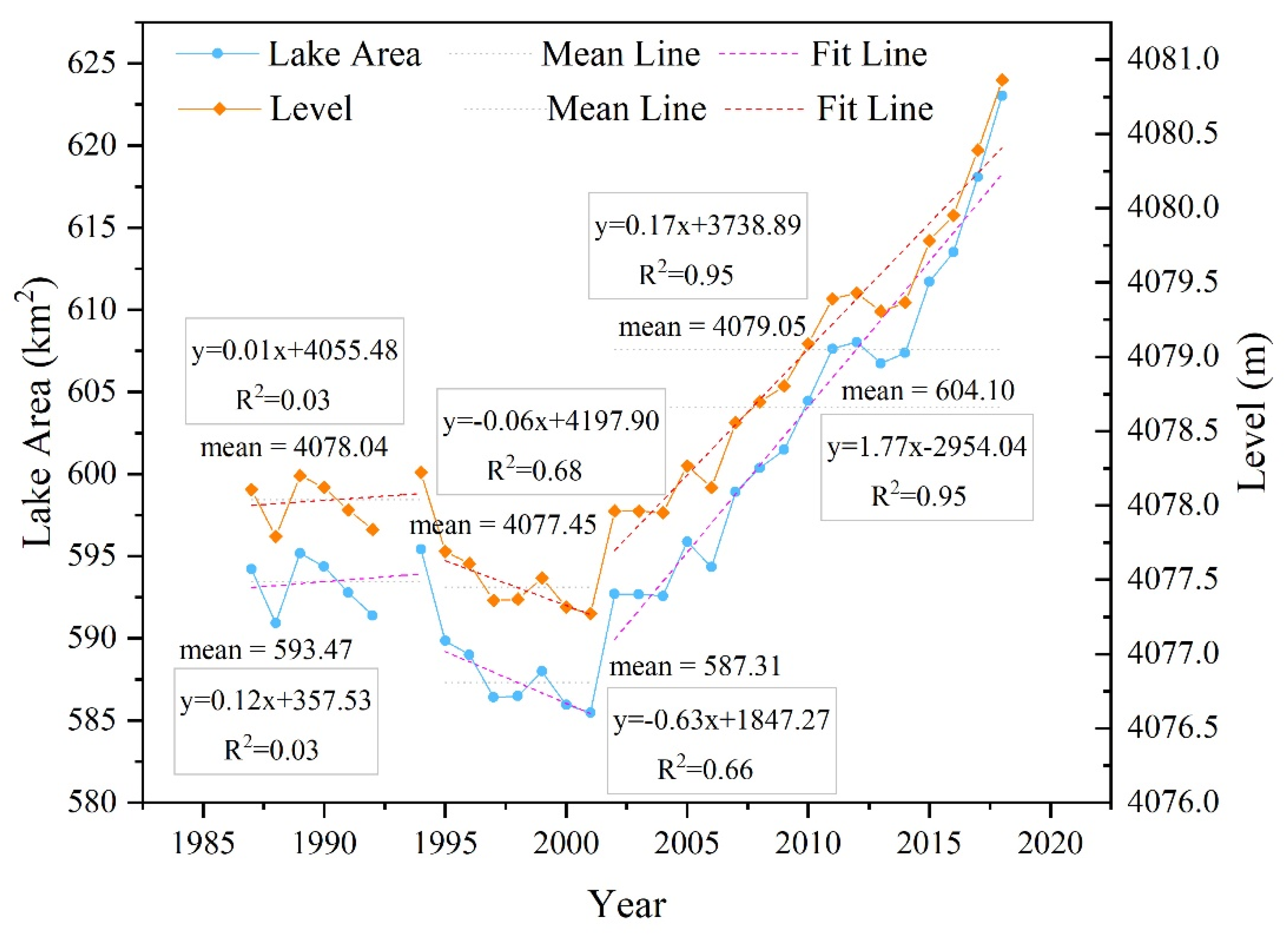
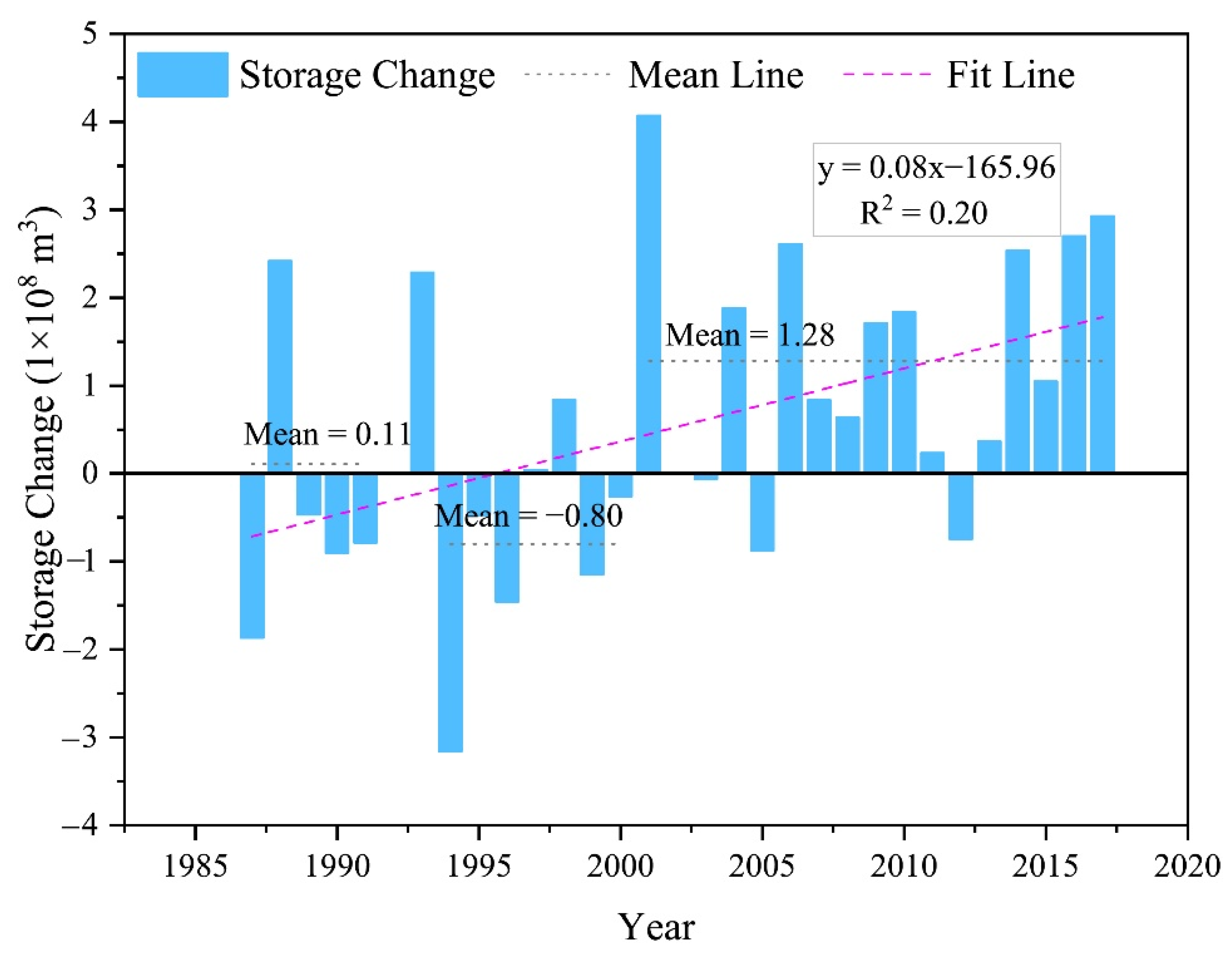
3.1. Changes in Area, Water Level and Storage of Hala Lake

As shown in Figure 3, the changes in the shoreline were mainly distributed in the north, southwest and southeast of the lake. The average annual area of Hala Lake was 593.47 ± 1.8   km 2 . From 1995 to 2001, the area of Hala Lake decreased continuously with a change rate of 1.42   km 2 · y 1 and reached the minimum area of 585.482   km 2 in 2001 (Figure 4). The area of Hala Lake expanded rapidly with a rate of 2.21   km 2 · y 1   from 2002 to 2018 and reached 623.031   km 2 in 2018.
The water level of Hala Lake increased slightly during 1987–1994 (Figure 4). The water level of Hala Lake was 4078.1 ± 0.13   m (Figure 4). The water level of Hala Lake decreased 0.71   m from 1995 to 2001 and reached the lowest level of 4077.272   m in 2001. The water level of Hala Lake rose by 3.59   m with a rate of 0.21   m · y 1 during 2002–2018 and reached a maximum of 4080.862   m in 2018 (Figure 4).
The average annual change of water storage of Hala Lake was 0.14 × 10 8   m 3 · y 1 during 1987–1994 (Figure 5). The storage of Hala Lake decreased 3.87 × 10 8   m 3 from 1995 to 2001 and increased by 21.69 × 10 8   m 3 , with an average annual increase rate of about 1.28 × 10 8   m 3 · y 1 , from 2002 to 2018 (Figure 5).

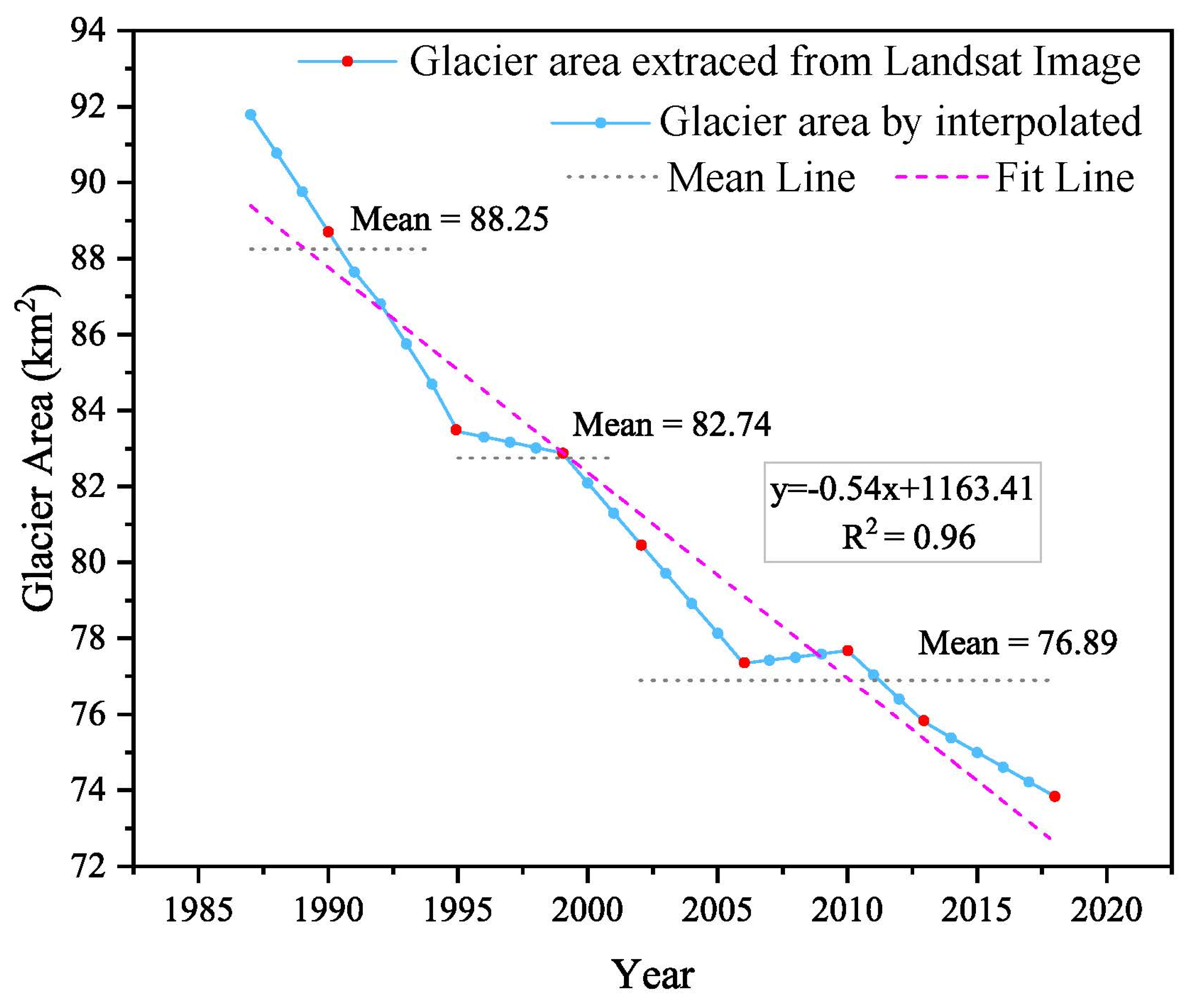
3.2. Glacier Area Change and Mass Loss in Hala Lake Basin

From 1987 to 2018, the glacier area of Hala Lake Basin declined (Figure 6). During 1987–1994, the glacier in Hala Lake Basin retreated about 7.07   km 2 . The annual glacial area decreased by 1.01   km 2 · y 1 , and annual glacial mass loss was about 2.23 × 10 8   m 3 · y 1 . The glacier area shrank at a rate of 0.48   km 2 · y 1 ,and glacial mass loss was about 1.05 × 10 8   m 3 · y 1 during 1995–2001. Between 2002 and 2018, the glacier area decreased from 81.3   km 2 to 73.84   km 2 . The annual glacial area declined 0.44   km 2 · y 1 and annual material loss was about   0.93 × 10 8   m 3 · y 1 .

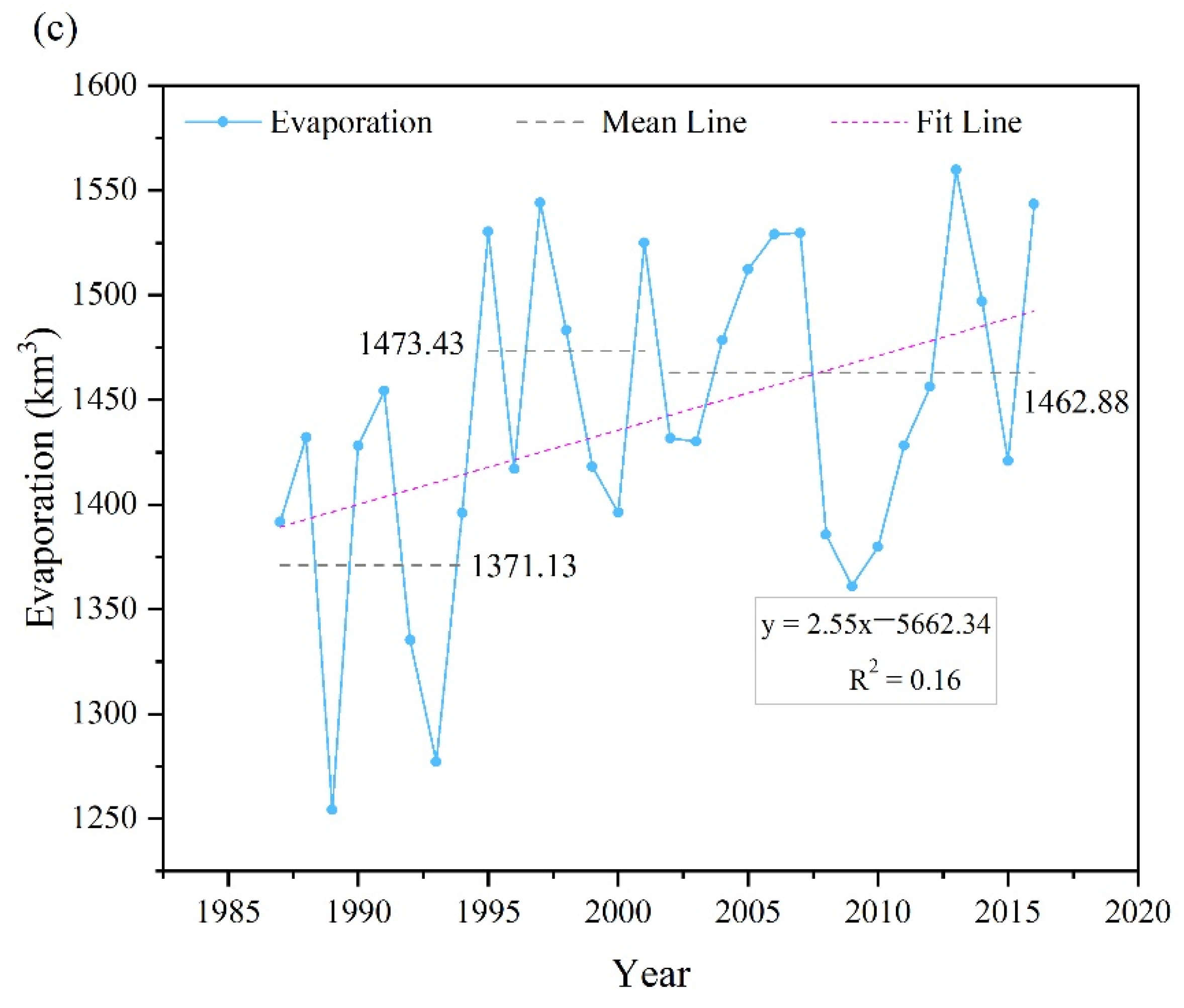
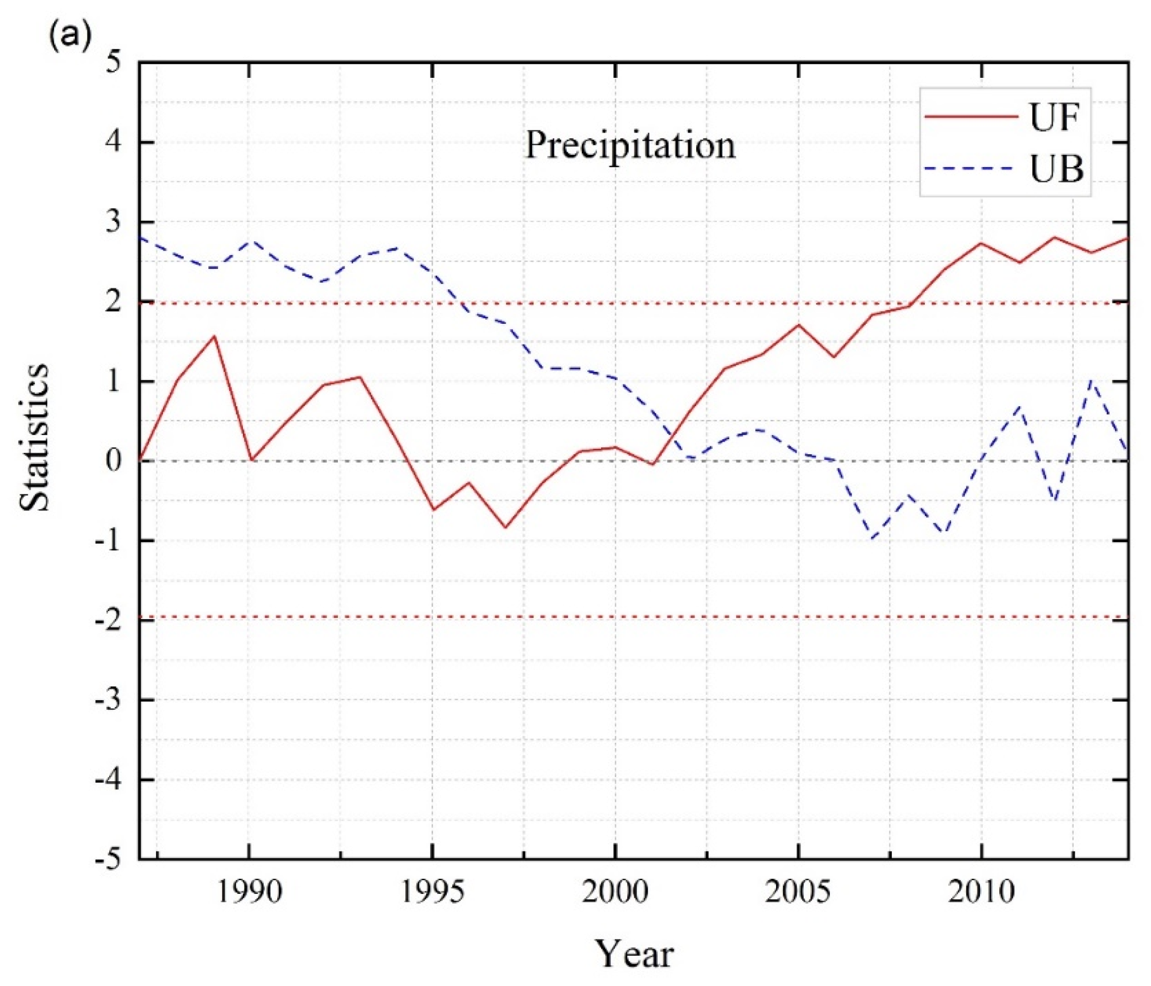
3.3. Changes in Climatic Parameters

From 1987 to 2018, precipitation in the Hala Lake Basin increased with fluctuations. The average annual precipitation from 1987 to 1994 was about 343   mm . From 1995 to 2001, which was the driest during the study period, the average annual precipitation decreased   29.2   mm compared to 1987 to 1994 (Figure 7a). As illustrated in Figure 8a, the Mann–Kendall step change point test showed that the change point of annual precipitation in the Hala Lake Basin occurred in 2001. The annual average precipitation increased by   106.9   mm compared with before 2001 (Figure 7a). The wetting trend is associated with simultaneously weakened westerlies over the TP [63].
The temperature of Hala Lake Basin was on the rise during the research period. During 1987–1994, the average annual temperature was 4.97   ° C. The average annual temperature of 1995–2001 was 0.57   ° C higher than that from 1987 to 1994 (Figure 7b). The temperature change point in the Hala Lake Basin occurred in 2001 (Figure 8b). The average annual temperature reached 4.0   ° C after 2001 (Figure 7b).
The evaporation in the Hala Lake Basin also increased with fluctuations. The annual average evaporation was 1371.5 mm during 1987–1994 and increased to 1473 mm from 1995 to 2001. During 2002–2018, the average annual evaporation was 1462 mm which was 90.5mm higher than the first stage but slightly lower than that from 1995 to 2001 (Figure 7c). The results of the Mann–Kendall test cannot indicate the change point of evaporation because the curves U F and U B intersect at three points (Figure 8c).

3.4. Water Balance of Hala Lake

The water supply of Hala Lake is mainly through runoff R and lake surface precipitation P w , and water loss is mainly through lake surface evaporation E w . The difference between supply and loss is the water storage change d V .
As shown in Table 1, the average annual runoff and lake surface precipitation were about 3.00 × 10 8   m 3 · y 1   and 2.03 × 10 8   m 3 · y 1 , respectively, and the average annual lake surface evaporation was 4.92 × 10 8   m 3 · y 1 from 1987 to 1994. At the same time, the average annual water storage change was 0.11 × 10 8   m 3 · y 1 . The area of Hala Lake experienced a slight increase during this period.
Hala Lake dropped in level and area during 1995–2001. The average annual runoff and lake surface precipitation in Hala Lake decreased by 0.54 × 10 8   m 3 · y 1 and 0.1 × 10 8   m 3 · y 1 than during 1987 to 1994, respectively, while evaporation increased, and the average annual water storage changed by −0.80 × 10 8   m 3 · y 1 .
The area of Hala Lake expanded rapidly from 2002 to 2018. The average annual runoff and water surface precipitation increased to 3.85 × 10 8   m 3 · y 1   and 2.76 × 10 8   m 3 · y 1 , respectively. Although lake evaporation increased with the expansion of Hala Lake, water supply was greater than loss, and the average annual water storage increased by 1.33 × 10 8   m 3 · y 1 .

4. Discussion on Storage Change of Hala Lake

4.1. The Driving Factors of Water Storage Change of Hala Lake

The water storage change of Hala Lake is the result of a variety of hydrometeorological factors. There was no significant change in precipitation and temperature in the Hala Lake Basin   p < 0.01 during 1987–1994. The glaciers retreated at the fastest rate in this stage over the study period. The annual average glacial mass loss account for 44 %   of lake water supply. The slight increase of water storage in Hala Lake (Table 1) may be caused by the mass loss of glaciers and the relatively low evaporation in the Basin at that time.
The water storage change of Hala Lake was affected mainly by precipitation and temperature (Table 2) from 1995 to 2001. The glacier continued to shrink with the temperature rise in the Hala Lake Basin. However, the annual average glacial mass loss only accounted for 24% of the lake’s water supply as the rate of glacial retreat declined. At the same time, precipitation was also on the decline in this stage. The lake water supply was 0.61 × 10 8   m 3 · y 1 lower than during 1987–1994. On the other hand, evaporation was the highest over the study period. The decline in precipitation and glacial mass loss with the increase in evaporation led to the shrinking of Hala Lake during this period.
During 2002–2018, the glaciers retreated at the lowest rate of the study period. The annual average glacial mass loss accounted for only 14.2 % of the water supply of Hala Lake. Remarkably, there was even a slight increase in the glacier area between 2006 and 2010. The annual average evaporation decreased slightly (Figure 8c) compared with 1995 to 2001. Less evaporation could be caused by more clouds and less solar radiation. However, the water lost to evaporation from the lake surface was higher than that of the previous stages (Table 1). Hala Lake was still in an expanding state which indicated that the increase of precipitation offset the effects of lake surface evaporation increase and glacial mass loss decrease and was the main reason for the expansion of Hala Lake.

4.2. Compared with Previous Studies

Comparing previous publications with this study, it can be seen that the changes of lakes and climate on the TP have spatial–temporal differences. In the southeast of the TP, Yamzho Yumco [64] and Paiku co [17] have decreased in water area and level in recent decades. In the central TP, Nam co Lake began to expand in 1971, and expansion accelerated after 1992 [21]. Co Nag, Daru Co, Dung Co, Pung Co, Co Ngoin, Bam Co and Neri Punco have experienced an obvious increase since 1997. The areas of Cuona Lake and Zigetang Lake greatly expanded after 1998 [65]. The step change points in precipitation in the central TP occurred in 1997 [37]. Aksai Chin Lake and Bangdag Co, located in the cool and dry northwest of the TP, have expanded since 1997 [66]. In the northeast of the TP, Hala Lake and Qinghai Lake began to expand after 2001 and 2004, respectively [6]. The step change points of temperature and precipitation in the Hala Lake Basin occurred in 2001.
The spatial–temporal differences in changes of lakes and climate over the TP could be connected with changes in atmospheric circulation from the 1990s. In the southeast of the TP, the decrease in rainfall, which is associated with a weakening of the Southern Oscillation and relaxation of the meridional temperature gradient over the Indian Ocean [67], lead to the shrinkage of lakes. In the inner TP, the increase of summer precipitation could be linked with the AMO. The AMO has been in a positive phase (warm anomaly of the North Atlantic Ocean surface) since the mid-1990s, which has led to both a northward shift and weakening of the subtropical westerly jet stream at 200 hPa near the TP through a wave train of cyclonic and anticyclonic anomalies over Eurasia. These anomalies are characterized by an anomalous anticyclone to the east of the internal TP and an anomalous cyclone to the west of the internal TP. The former weakens the westerly winds, trapping water vapor over the inner TP, while the latter facilitates water vapor intruding from the Arabian Sea into the inner TP [63]. The poleward shift of the East Asian westerly jet stream [68] and the enhanced East Asian Summer Monsoon circulation under a warming climate [69] could be responsible for the wetting trend in the north (including the northwest and the northeast) of the TP.
Some studies have revealed that glacier melting has been accelerated in the past decade over the TP [70,71,72]. However, the rate of glacial retreat in the Hala Lake Basin has slowed over the study period. The contribution of glacial mass loss on lake expansion on the TP has also showed spatial–temporal variability. The study of Lei et al. [73] showed that glacier mass loss accounted for 11.7 % , 28.7 %   and 11.4 %   of the total lake level rise of Siling Co, Nam Co and Pung Co, respectively. Ke et al. [72] revealed that the massive lake water increase was essentially not from the mass loss of glaciers which represents only about 4.7 ± 8.8% of the lake water change. Brun et al. [74] demonstrated that glacier mass loss did have a limited contribution to the lake volume increase (19 ± 21% for the whole Tibetan plateau) from 1994 to 2015. The results of Wu [75] showed that the glacier mass loss in the Hala Lake Basin accounted for 39.65 % of the increase of water storage in Hala Lake during 2000–2016. The contribution of glacier mass loss to the Hala Lake expansion was overestimated in the study of Wu because he did not consider water surface evaporation, which is the main consumption mode of inland lakes.

5. Conclusions

In this study, changes in Hala Lake, glaciers and climate change in the Hala Lake Basin were investigated. The driving factors of the changing dynamics of Hala Lake were analyzed.
During 1987–2018, Hala Lake has undergone three stages of slight expansion, shrinkage and rapid expansion. During 1987–1994, the area of Hala Lake was relatively stable, with an average area of 593.47   km 2 and an average water level of 4078.1   m . The water level and storage of Hala Lake decreased by 0.95   m   and 5.61 × 10 8   m 3 from 1995 to 2001 respectively. The area of Hala Lake shrank to 585.482   km 2 in 2001, which was the smallest over the study period. Hala Lake expanded rapidly from 2002 to 2018. By 2018, the area had expanded to 623.10   km 2 . The water level and storage increased by 3.59   m and 21.69 × 10 8   m 3   during 2002–2018.
The rate of glacier melting continued to decline during the study period. The annual average glacial mass loss due to rising temperatures accounted for 44%, 24% and 14.2% of lake recharge during 1987–1994, 1995–2001, 2002–2018, respectively.
Precipitation is the main factor in the rapid expansion of Hala Lake during 2002–2018. This study also found that the time of Hala Lake’s rapid expansion was closely associated with the step change points of annual precipitation and temperature based on the Mann–Kendall test.
From 2011 to 2100, the overall change in regional average annual precipitation is not evident, and air temperatures increase monotonously in the Qilian Mountains [76]. An increase in meltwater from glaciers caused by higher temperatures could lead to the expansion of Hala Lake. At the same time, higher temperatures and larger areas of Hala Lake also led to more consumption of lake water. Hala Lake will be in a stable state when lake water supply and consumption balance in the future.

Author Contributions

Conceptualization, Z.J. and J.W.; methodology, H.Z.; software, Y.Z.; validation, J.Z.; data curation, H.Z. and C.W.; writing—original draft preparation, Z.J. and J.W.; writing—review and editing, X.C. All authors have read and agreed to the published version of the manuscript.

Funding

This research supported by the National Natural Science Foundation of China (Grand No.41201437; Grand No.41861015; Grand No.42171381) and the Fundamental Research Funds for the Central Universities (lzujbky-2021-ey05).

Data Availability Statement

Data available on request from the first author.

Conflicts of Interest

The authors declare no conflict of interest.

References

  1. Chen, B.; Zhang, X.; Tao, J.; Wu, J.; Wang, J.; Shi, P.; Zhang, Y.-J.; Yu, C. The impact of climate change and anthropogenic activities on alpine grassland over the Qinghai-Tibet Plateau. Agric. For. Meteorol. 2014, 189–190, 11–18. [Google Scholar] [CrossRef]
  2. Immerzeel, W.W.; Van Beek, L.P.H.; Bierkens, M.F.P. Climate change will affect the Asian Water Towers. Science 2010, 328, 1382–1385. [Google Scholar] [CrossRef] [PubMed]
  3. Lei, Y.; Zhu, Y.; Wang, B.; Yao, T.; Yang, K.; Zhang, X.; Zhai, J.; Ma, N. Extreme Lake Level Changes on the Tibetan Plateau Associated With the 2015/2016 El Niño. Geophys. Res. Lett. 2019, 46, 5889–5898. [Google Scholar] [CrossRef]
  4. Yang, R.; Zhu, L.; Wang, J.; Ju, J.; Ma, Q.; Turner, F.; Guo, Y. Spatiotemporal variations in volume of closed lakes on the Tibetan Plateau and their climatic responses from 1976 to 2013. Clim. Chang. 2017, 140, 621–633. [Google Scholar] [CrossRef]
  5. Yang, R.; Zhu, L.; Liu, C.; Ju, J.; Qiao, B.; Han, B. Recent lake changes of the Asia Water Tower and their climate response: Progress, problems and prospects. Chin. Sci. Bull. 2019, 64, 2796–2806. [Google Scholar] [CrossRef] [Green Version]
  6. Luo, C.; Xu, C.; Cao, Y.; Tong, L. Monitoring of water surface area in Lake Qinghai from 1974 to 2016. J. Lake Sci. 2017, 29, 1245–1253. [Google Scholar] [CrossRef] [Green Version]
  7. Zhang, G.; Xie, H.; Kang, S.; Yi, D.; Ackley, S.F. Monitoring lake level changes on the Tibetan Plateau using ICESat altimetry data (2003–2009). Remote Sens. Environ. 2011, 115, 1733–1742. [Google Scholar] [CrossRef]
  8. Zhang, G.; Xie, H.; Duan, S.; Tian, M.; Yi, D. Water level variation of Lake Qinghai from satellite and in situ measurements under climate change. J. Appl. Remote Sens. 2011, 5, 053532. [Google Scholar] [CrossRef]
  9. Song, C.; Ye, Q.; Cheng, X. Shifts in water-level variation of Namco in the central Tibetan Plateau from ICESat and CryoSat-2 altimetry and station observations. Sci. Bull. 2015, 60, 1287–1297. [Google Scholar] [CrossRef] [Green Version]
  10. Song, C.; Huang, B.; Ke, L.; Richards, K.S. Seasonal and abrupt changes in the water level of closed lakes on the Tibetan Plateau and implications for climate impacts. J. Hydrol. 2014, 514, 131–144. [Google Scholar] [CrossRef]
  11. Zhang, B.; Wu, Y.; Zhu, L.; Wang, J.; Li, J.; Chen, D. Estimation and trend detection of water storage at Nam Co Lake, central Tibetan Plateau. J. Hydrol. 2011, 405, 161–170. [Google Scholar] [CrossRef]
  12. Song, C.; Huang, B.; Ke, L. Modeling and analysis of lake water storage changes on the Tibetan Plateau using multi-mission satellite data. Remote Sens. Environ. 2013, 135, 25–35. [Google Scholar] [CrossRef]
  13. Zhang, J.; Hu, Q.; Li, Y.; Li, H.; Li, J. Area, lake-level and volume variations of typical lakes on the Tibetan Plateau and their response to climate change, 1972–2019. Geo-Spat. Inf. Sci. 2021, 24, 458–473. [Google Scholar] [CrossRef]
  14. Li, Y.; Liao, J.; Guo, H.; Liu, Z.; Shen, G. Patterns and Potential Drivers of Dramatic Changes in Tibetan Lakes, 1972–2010. PLoS ONE 2014, 9, e111890. [Google Scholar] [CrossRef] [Green Version]
  15. Wan, W.; Xiao, P.; Feng, X.; Li, H.; Ma, R.; Duan, H.; Zhao, L. Monitoring lake changes of Qinghai-Tibetan Plateau over the past 30 years using satellite remote sensing data. Chin. Sci. Bull. 2014, 59, 1021–1035. [Google Scholar] [CrossRef]
  16. Lei, Y.; Yang, K.; Wang, B.; Sheng, Y.; Bird, B.W.; Zhang, G.; Tian, L. Response of inland lake dynamics over the Tibetan Plateau to climate change. Clim. Chang. 2014, 125, 281–290. [Google Scholar] [CrossRef]
  17. Lei, Y.; Yao, T.; Yang, K.; Bird, B.W.; Tian, L.; Zhang, X.; Wang, W.; Xiang, Y.; Dai, Y.; Zhou, J.; et al. An integrated investigation of lake storage and water level changes in the Paiku Co basin, central Himalayas. J. Hydrol. 2018, 562, 599–608. [Google Scholar] [CrossRef] [Green Version]
  18. Ye, Q.; Zhu, L.; Zheng, H.; Naruse, R.; Zhang, X.; Kang, S. Glacier and lake variations in the Yamzhog Yumco basin, southern Tibetan Plateau, from 1980 to 2000 using remote-sensing and GIS technologies. J. Glaciol. 2007, 53, 673–676. [Google Scholar] [CrossRef] [Green Version]
  19. Chu, D.; Qiong, P.U.; Zhuoma, L.; Zhu, L.; Zhang, X.; Ciren, P.; Yangzongamp, D.; Rui, S. Remote sensing analysis on lake area variations of Yamzho Yumco in Tibetan Plateau over the past 40 a. J. Lake Sci. 2012, 24, 494–502. [Google Scholar] [CrossRef]
  20. Wu, H.; Jiang, Q.; Cheng, B. Study of dynamic changes of lakes in Qinghai-Tibet Plateau based on remote sensing and GIS. Glob. Geol. 2007, 26, 66–70. [Google Scholar] [CrossRef]
  21. Zhu, L.; Xie, M.; Wu, Y. Quantitative analysis of lake area variations and the influence factors from 1971 to 2004 in the Nam Co basin of the Tibetan Plateau. Chin. Sci. Bull. 2010, 55, 1294–1303. [Google Scholar] [CrossRef]
  22. Song, C.; Sheng, Y. Contrasting evolution patterns between glacier-fed and non-glacier-fed lakes in the Tanggula Mountains and climate cause analysis. Clim. Chang. 2015, 135, 493–507. [Google Scholar] [CrossRef]
  23. Qiao, B.; Zhu, L. Differences and cause analysis of changes in lakes of different supply types in the north-western Tibetan Plateau. Hydrol. Process. 2017, 31, 2752–2763. [Google Scholar] [CrossRef]
  24. Zhang, G.; Yao, T.; Shum, C.K.; Yi, S.; Yang, K.; Xie, H.; Feng, W.; Bolch, T.; Wang, L.; Behrangi, A.; et al. Lake volume and groundwater storage variations in Tibetan Plateau’s endorheic basin. Geophys. Res. Lett. 2017, 44, 5550–5560. [Google Scholar] [CrossRef]
  25. Yang, K.; Wu, H.; Qin, J.; Lin, C.; Tang, W.; Chen, Y. Recent climate changes over the Tibetan Plateau and their impacts on energy and water cycle: A review. Glob. Planet. Chang. 2014, 112, 79–91. [Google Scholar] [CrossRef]
  26. Zhou, J.; Wang, L.; Zhang, Y.; Guo, Y.; Li, X.; Liu, W. Exploring the water storage changes in the largest lake (Selin Co) over the Tibetan Plateau during 2003–2012 from a basin-wide hydrological modeling. Water Resour. Res. 2015, 51, 8060–8086. [Google Scholar] [CrossRef] [Green Version]
  27. Biskop, S.; Maussion, F.; Krause, P.; Fink, M. Differences in the water-balance components of four lakes in the southern-central Tibetan Plateau. Hydrol. Earth Syst. Sci. 2016, 20, 209–225. [Google Scholar] [CrossRef] [Green Version]
  28. Zhang, Y.; Liu, C.; Tang, Y.; Yang, Y. Trends in pan evaporation and reference and actual evapotranspiration across the Tibetan Plateau. J. Geophys. Res. Atmos. 2007, 112, 1–12. [Google Scholar] [CrossRef]
  29. You, Q.; Kang, S.; Flügel, W.-A.; Pepin, N.; Yan, Y.; Huang, J. Decreasing wind speed and weakening latitudinal surface pressure gradients in the Tibetan Plateau. Clim. Res. 2010, 42, 57–64. [Google Scholar] [CrossRef] [Green Version]
  30. Lin, C.; Yang, K.; Qin, J.; Fu, R. Observed Coherent Trends of Surface and Upper-Air Wind Speed over China since 1960. J. Clim. 2013, 26, 2891–2903. [Google Scholar] [CrossRef] [Green Version]
  31. Ma, N.; Szilagyi, J.; Niu, G.-Y.; Zhang, Y.; Zhang, T.; Wang, B.; Wu, Y. Evaporation variability of Nam Co Lake in the Tibetan Plateau and its role in recent rapid lake expansion. J. Hydrol. 2016, 537, 27–35. [Google Scholar] [CrossRef]
  32. Yao, T.D.; Thompson, L.; Yang, W.; Yu, W.S.; Gao, Y.; Guo, X.J.; Yang, X.X.; Duan, K.Q.; Zhao, H.B.; Xu, B.Q.; et al. Different glacier status with atmospheric circulations in Tibetan Plateau and surroundings. Nat. Clim. Chang. 2012, 2, 663–667. [Google Scholar] [CrossRef]
  33. Yao, T.; Masson-Delmotte, V.; Gao, J.; Yu, W.; Yang, X.; Risi, C.; Sturm, C.; Werner, M.; Zhao, H.; He, Y.; et al. A review of climatic controls on δ18O in precipitation over the Tibetan Plateau: Observations and simulations. Rev. Geophys. 2013, 51, 525–548. [Google Scholar] [CrossRef]
  34. An, Z.; Kutzbach, J.E.; Prell, W.L.; Porter, S.C. Evolution of Asian monsoons and phased uplift of the Himalaya–Tibetan plateau since Late Miocene times. Nature 2001, 411, 62–66. [Google Scholar] [CrossRef]
  35. Cao, J.; Zhang, J.W.; Zhang, C.J.; Chen, F.H. Environmental Changes During the Past 800 Years Recorded in Lake Sediments from Hala Lake on The Northern Tibetan Plateau. Quat.Sci. 2007, 27, 100–107. [Google Scholar] [CrossRef]
  36. McFeeters, S.K. The use of the Normalized Difference Water Index (NDWI) in the delineation of open water features. Int. J. Remote Sens. 1996, 17, 1425–1432. [Google Scholar] [CrossRef]
  37. Zhang, R.; Zhu, L.; Ma, Q.; Chen, H.; Liu, C.; Zubaida, M. The consecutive lake group water storage variations and their dynamic response to climate change in the central Tibetan Plateau. J. Hydrol. 2021, 601, 126615. [Google Scholar] [CrossRef]
  38. Gao, H. Satellite remote sensing of large lakes and reservoirs: From elevation and area to storage. WIREs Water 2015, 2, 147–157. [Google Scholar] [CrossRef]
  39. Urban, T.J.; Schutz, B.E.; Neuenschwander, A.L. A Survey of ICESat Coastal Altimetry Applications: Continental Coast, Open Ocean Island, and Inland River. Terr. Atmos. Ocean. Sci. 2008, 19, 1–19. [Google Scholar] [CrossRef] [Green Version]
  40. Jarihani, A.A.; Callow, J.N.; Johansen, K.; Gouweleeuw, B. Evaluation of multiple satellite altimetry data for studying inland water bodies and river floods. J. Hydrol. 2013, 505, 78–90. [Google Scholar] [CrossRef]
  41. Cai, X.; Gan, W.; Ji, W.; Zhao, X.; Wang, X.; Chen, X. Optimizing Remote Sensing-Based Level–Area Modeling of Large Lake Wetlands: Case Study of Poyang Lake. IEEE J. Sel. Top. Appl. Earth Obs. Remote Sens. 2014, 8, 471–479. [Google Scholar] [CrossRef]
  42. Racoviteanu, A.; Paul, F.; Raup, B.; Khalsa, S.J.; Armstrong, R. Challenges and recommendations in mapping of glacier parameters from space: Results of the 2008 Global Land Ice Measurements from Space (GLIMS) Workshop, Boulder, Colorado, USA. Ann. Glaciol. 2009, 50, 53–69. [Google Scholar] [CrossRef] [Green Version]
  43. Andreassen, L.M.; Paul, F.; Kääb, A.; Hausberg, J.E. Landsat-derived glacier inventory for Jotunheimen, Norway, and deduced glacier changes since the 1930s. Cryosphere 2008, 2, 131–145. [Google Scholar] [CrossRef] [Green Version]
  44. Paul, F.; Kääb, A. Perspectives on the production of a glacier inventory from multispectral satellite data in Arctic Canada: Cumberland Peninsula, Baffin Island. Ann. Glaciol. 2005, 42, 59–66. [Google Scholar] [CrossRef] [Green Version]
  45. Vincent, L. Morphological grayscale reconstruction in image analysis: Applications and efficient algorithms. IEEE Trans. Image Process. 1993, 2, 176–201. [Google Scholar] [CrossRef] [PubMed] [Green Version]
  46. Bolch, T.; Menounos, B.; Wheate, R. Landsat-based inventory of glaciers in western Canada, 1985–2005. Remote Sens. Environ. 2010, 114, 127–137. [Google Scholar] [CrossRef]
  47. Radić, V.; Hock, R. Glaciers in the Earth’s Hydrological Cycle: Assessments of Glacier Mass and Runoff Changes on Global and Regional Scales. Surv. Geophys. 2013, 35, 813–837. [Google Scholar] [CrossRef]
  48. Gao, Y.P.; Yao, X.J.; Liu, S.Y.; Qi, M.M.; Gong, P.; An, N.N.; Li, X.F.; Duan, Y.H. Methods and Future Trend of Ice Volume Calculation of Glacier. Arid Land Geogr. 2018, 41, 64–73. [Google Scholar] [CrossRef]
  49. Adhikari, S.; Marshall, S.J. Glacier volume-area relation for high-order mechanics and transient glacier states. Geophys. Res. Lett. 2012, 39, 132–133. [Google Scholar] [CrossRef]
  50. Bahr, D.B.; Meier, M.F.; Peckham, S. The physical basis of glacier volume-area scaling. J. Geophys. Res. Solid Earth 1997, 102, 20355–20362. [Google Scholar] [CrossRef]
  51. Liu, S.; Sun, W.; Shen, Y.; Gang, L. Glacier changes since the Little Ice Age maximum in the western Qilian Shan, northwest China, and consequences of glacier runoff for water supply. J. Glaciol. 2003, 49, 117–124. [Google Scholar] [CrossRef] [Green Version]
  52. Huss, M. Density assumptions for converting geodetic glacier volume change to mass change. Cryosphere 2013, 7, 877–887. [Google Scholar] [CrossRef] [Green Version]
  53. Liu, S.; Yao, X.; Guo, W.; Xu, J.; Shangguan, D.; Wei, J.; Bao, W.; Wu, L. The contemporary glaciers in China based on the Second Chinese Glacier Inventory. Acta Geogr. Sin. 2015, 70, 3–16. [Google Scholar] [CrossRef]
  54. Ren, G.H.; Li, M.Q.; Zhang, W.M. Conversion Coefficient of Small Evaporation Pan into E-601B Pan in China. J. Appl. Meteorol. Sci. 2002, 13, 508–512. [Google Scholar] [CrossRef]
  55. Shi, C.X.; Niu, K.Y.; Chen, T.Z.; Zhu, X.Y. The Study of Pan Coefficients of Evaporation Pans of Water. Sci. Geogr. Sin. 1986, 6, 305–313. [Google Scholar] [CrossRef]
  56. Mann, H.B. Nonparametric tests against trend. Econometrica 1945, 13, 245–259. [Google Scholar] [CrossRef]
  57. Kendall, M.G. Rank Correlation Measures; Charles Griffin: London, UK, 1975; Volume 202, p. 12. [Google Scholar]
  58. Sneyers, R. Sur l’analyse statistique des séries d’observations. Ciel Terre 1977, 93, 186. [Google Scholar]
  59. Goossens, C.; Berger, A. Annual and Seasonal Climatic Variations over the Northern Hemisphere and Europe during the Last Century. Ann. Geophys. 1986, 4, 385–400. [Google Scholar]
  60. Fu, C.B.; Wang, Q. The Difinition and Detection of the Abrupt Climatic Change. Sci. Atmos. Sin. 1992, 16, 482–493. [Google Scholar] [CrossRef]
  61. Li, B.; Chen, Y.; Xiong, H. Quantitatively evaluating the effects of climate factors on runoff change for Aksu River in northwestern China. Theor. Appl. Climatol. 2016, 123, 97–105. [Google Scholar] [CrossRef]
  62. Shen, S.; Song, C.; Cheng, C.; Ye, S. The coupling impact of climate change on streamflow complexity in the headwater area of the northeastern Tibetan Plateau across multiple timescales. J. Hydrol. 2020, 588, 124996. [Google Scholar] [CrossRef]
  63. Sun, J.; Yang, K.; Guo, W.; Wang, Y.; He, J.; Lu, H. Why Has the Inner Tibetan Plateau Become Wetter since the Mid-1990s? J. Clim. 2020, 33, 8507–8522. [Google Scholar] [CrossRef]
  64. Bian, D.; Du, J.; Hu, J. Response of the water level of the Yamzho Yumco to climate change during 1975-2006. J. Glaciol. Geocryol. 2009, 31, 6. [Google Scholar]
  65. Liu, J.; Wang, S.; Yu, S.; Yang, D.; Zhang, L. Climate warming and growth of high-elevation inland lakes on the Tibetan Plateau. Glob. Planet. Chang. 2009, 67, 209–217. [Google Scholar] [CrossRef]
  66. Qiao, B.; Zhu, L.; Wang, J.; Ju, J.; Ma, Q.; Liu, C. Estimation of lakes water storage and their changes on the northwestern Tibetan Plateau based on bathymetric and Landsat data and driving force analyses. Quat. Int. 2017, 454, 56–67. [Google Scholar] [CrossRef]
  67. Naidu, C.V.; Durgalakshmi, K.; Krishna, K.M.; Rao, S.R.; Satyanarayana, G.C.; Lakshminarayana, P.; Rao, L.M. Is summer monsoon rainfall decreasing over India in the global warming era? J. Geophys. Res. Atmos. 2009, 114. [Google Scholar] [CrossRef] [Green Version]
  68. Gao, Y.; Cuo, L.; Zhang, Y. Changes in Moisture Flux over the Tibetan Plateau during 1979–2011 and Possible Mechanisms. J. Clim. 2014, 27, 1876–1893. [Google Scholar] [CrossRef]
  69. He, C.; Wang, Z.; Zhou, T.; Li, T. Enhanced Latent Heating over the Tibetan Plateau as a Key to the Enhanced East Asian Summer Monsoon Circulation under a Warming Climate. J. Clim. 2019, 32, 3373–3388. [Google Scholar] [CrossRef]
  70. Hugonnet, R.; McNabb, R.; Berthier, E.; Menounos, B.; Nuth, C.; Girod, L.; Farinotti, D.; Huss, M.; Dussaillant, I.; Brun, F.; et al. Accelerated global glacier mass loss in the early twenty-first century. Nature 2021, 592, 726–731. [Google Scholar] [CrossRef]
  71. Zhou, Y.; Li, Z.; Li, J.; Zhao, R.; Ding, X. Glacier mass balance in the Qinghai–Tibet Plateau and its surroundings from the mid-1970s to 2000 based on Hexagon KH-9 and SRTM DEMs. Remote Sens. Environ. 2018, 210, 96–112. [Google Scholar] [CrossRef]
  72. Ke, L.; Song, C.; Wang, J.; Sheng, Y.; Ding, X.; Yong, B.; Ma, R.; Liu, K.; Zhan, P.; Luo, S. Constraining the contribution of glacier mass balance to the Tibetan lake growth in the early 21st century. Remote Sens. Environ. 2021, 268, 112779. [Google Scholar] [CrossRef]
  73. Lei, Y.; Yao, T.; Bird, B.W.; Yang, K.; Zhai, J.; Sheng, Y. Coherent lake growth on the central Tibetan Plateau since the 1970s: Characterization and attribution. J. Hydrol. 2013, 483, 61–67. [Google Scholar] [CrossRef]
  74. Brun, F.; Treichler, D.; Shean, D.; Immerzeel, W.W. Limited Contribution of Glacier Mass Loss to the Recent Increase in Tibetan Plateau Lake Volume. Front. Earth Sci. 2020, 8, 495. [Google Scholar] [CrossRef]
  75. Wu, H.B.; Yang, M.; Yang, C.L.; Li, Y.N. Effect of glacier mass loss on water level fluctuation of lake in Hala Lake basin. J. Water Resour. Water Eng. 2016, 27, 13–20. [Google Scholar] [CrossRef]
  76. Liu, L.-Y.; Wang, X.-J.; Gou, X.-H.; Yang, M.-X.; Zhang, Z.-H. Projections of surface air temperature and precipitation in the 21st century in the Qilian Mountains, Northwest China, using REMO in the CORDEX. Adv. Clim. Chang. Res. 2022, 13, 344–358. [Google Scholar] [CrossRef]
Figure 1. Map of the Hala Lake Basin.
Remotesensing 14 02886 g001
Figure 2. Relationship between the water level of Hala Lake and its lake area.
Remotesensing 14 02886 g002
Figure 3. The changes in the shorelines of Hala Lake during 1987–2018.
Remotesensing 14 02886 g003
Figure 4. The water area and level of Hala Lake during 1987–2018.
Remotesensing 14 02886 g004
Figure 5. The storage change of Hala Lake during 1987–2018.
Remotesensing 14 02886 g005
Figure 6. The area of glaciers in the Hala Lake Basin from 1997 to 2018.
Remotesensing 14 02886 g006
Figure 7. The changes in precipitation, temperature and evaporation of the Hala Lake Basin from 1987 to 2018.
Remotesensing 14 02886 g007aRemotesensing 14 02886 g007b
Figure 8. Trend test and abrupt change point detection of temperature, precipitation and evaporation in the Hala Lake watershed; the red dotted lines are the thresholds at a significant level of 95%; statistics are the values of UF and UB.
Remotesensing 14 02886 g008aRemotesensing 14 02886 g008b
Table 1. The Hala Lake water balance from 1987 to 2018.
Water Balance Components1987–19941995–20012002–2018
Annual Average
( 1 × 10 8   m 3   y 1 )
Annual Average
( 1 × 10 6   m 3   y 1 )
Annual Average
( 1 × 10 6   m 3   y 1 )
Lake water supply R 3.02.463.85
P w 2.031.932.76
Loss of lake water E W 4.925.195.28
d v *+0.11−0.80+1.33
* “−” means a decrease in water storage; “+” indicates an increase in water storage.
Table 2. The Pearson correlation coefficient between the storage change of Hala Lake and climate factors.
d v P T E
1987–2018 0.4   0.31   + 0.06
1987–1994 0.28 0.04 0.14
1995–2001 0.91   0.80   0.54
2002–2018 0.45 + 0.07 0.20
Note: + p < 0.1 ; * p < 0.05 ; ** p < 0.01 (significant at these levels). d v : Storage change of Hala Lake; P : Precipitation; T: Temperature; E: Evaporation.
Publisher’s Note: MDPI stays neutral with regard to jurisdictional claims in published maps and institutional affiliations.

