

Effects of Urban Planning on Ecosystem Services: The Umbria Region Seismic Crater


Department of Civil, Construction-Architectural and Environmental Engineering, University of L’Aquila, Via Giovanni Gronchi, 16, 67100 L’Aquila, Italy
*
Author to whom correspondence should be addressed.
Sustainability 2023, 15(9), 7674; https://doi.org/10.3390/su15097674
Submission received: 23 March 2023
/
Revised: 3 May 2023
/
Accepted: 5 May 2023
/
Published: 7 May 2023
(This article belongs to the Special Issue Sustainable Spatial Planning Based on Ecosystem Services, Green Infrastructure and Nature-Based Solutions)
Abstract
:The earthquake in central Italy in 2016 led to a profound urban and natural landscape transformation. The role of territorial planning in this kind of situation is extremely important because it allows the orientation of future settlement choices through appropriate interpretative keys of the existing territorial dynamics. This work aims to analyze the effects of the planning choices made in the post-earthquake period in the seismic crater municipalities of the Umbria region. Using the InVEST models, these studies regard the comparison of the effects of in-force plans on ecosystem services such as habitat quality and carbon storage. The data about the mosaic of the municipal urban planning tools are derived from specific actions produced under two LIFE projects (SUNLIFE and IMAGINE). The comparison makes it possible to identify how and to what extent the transformative scenarios, linked to the new condition, change the spatial planning compared to the previous one and the effects on the provision of ecosystem services. The knowledge of the latter aspect allows optimization of the methods of urban transformation that will be implemented. Moreover, this process of optimizing the provision of essential ecosystem services could certainly play a key role in the enhancement and economic recovery of these areas.
1. Introduction
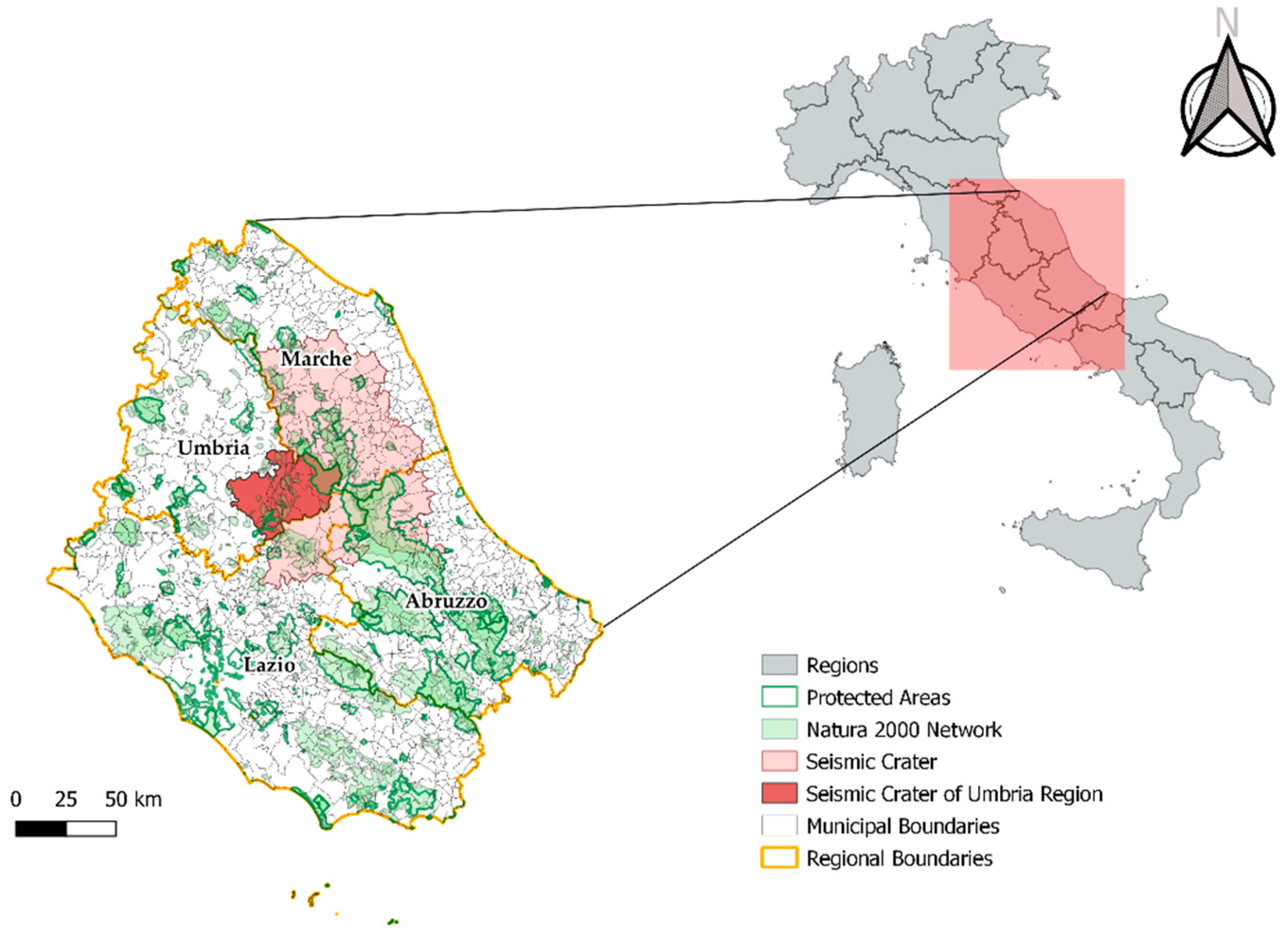
Among the most seismically dangerous areas in Europe, the Italian Apennines have, in recent years, been affected by numerous seismic events of significant intensity [1,2]. The seismic events caused significant damage to the historical centers, and consequently, a reorganization of urban structures [3,4]. This reorganization was highly dependent on the demographic and urban dimensions of the municipalities involved. It has had an internal structural component (aimed at rebuilding the damaged heritage) and a functional external one (both assigning new roles to the centers and recreating relationships). Both processes are still ongoing and have led to a new urban geography of the inner areas of central Italy. The earthquakes that occurred from 2009 to 2016 affected several important urban centers (L’Aquila 2009; Amatrice 2016; Norcia 2017) located in four different Italian regions (Umbria, Abruzzo, Lazio, and Marche) [5]. Following each earthquake, several regulative measures were issued with the aim of defining the municipalities concerned within which the reconstruction processes were defined. The effects of the earthquake directly affected economic activities, housing stock, and local communities, and also, the indirect effects on the environmental system were not negligible. There were effects such as: landscape fragmentation, the loss of crops and food resources, deteriorating water quality and water availability, soil erosion that led to the future reduction in agricultural production, the loss or deterioration of natural habitat, and threatened or reduced biodiversity [6,7,8,9]. The regulations issued in the various seismic craters have generated an important consumption of soil related to the construction in different areas of “temporary” housing, much of which today needs indispensable support from recovery operations (e.g., project C.A.S.E. (Sustainable and Eco-friendly Seismic Complexes) and the S.A.E. (Housing Solutions in Emergency)), and also for the possibility of providing their own accommodation [10]. Many of these achievements largely escaped the control of spatial planning and contributed to an increase in the pre-existing dispersed configuration that characterized these areas [11]. Often many of these buildings were built in areas at risk (landslides, floods) and without considering the environmental component. For example, little attention has been paid to the effects on the environmental system in terms of the loss of ecosystem services, environmental fragmentation, habitat degradation, and habitat loss [12,13,14]. Figure 1 shows that the central Apennines represents an extremely important reservoir of biodiversity in the national and European context. There are in fact several National Parks and Natura 2000 network sites. As for the Umbria region, the protected territory corresponds to 19% of the entire regional area, which consists of a National Park, seven Regional Parks, and numerous areas of the Natura 2000 network. This paper focuses on the urban transformations that have affected the municipalities of the 2016 earthquake crater in the Umbria region with the aim of evaluating the effects of these changes on the ecosystem services (carbon storage and sequestration and habitat quality) while analyzing whether, in the municipalities that have updated their urban plan, the important aspect of the ecological value of these territories has been considered.
2. Study Area
The study area concerns the 15 municipalities of the Umbria region included in the seismic crater of 2016 (Figure 1). A first list was compiled with the Decree-Law No. 189 of 17 October 2016 inserting 62 centers distributed over 4 regions. This list was then updated with Decree-Law No. 205 of 11 November 2016 following the earthquake of 30 October 2016, before arriving at the final list of the 69 municipalities included in the seismic crater described in Annex 2 of Law No. 229 of 15 December 2016. In summary, the 2016 earthquake involved 4 regions, 10 provinces, and 138 municipalities [15]. The studied area covers an area of 1400 km2 (17% of the regional area). In these municipalities, the population in 2021 was about 55,000 inhabitants (6.4% of the regional population). This value is lower than the 2016 population which was 57,560 inhabitants, equal to 6.5% of the regional population [16]. From an environmental point of view, 5% of the study area is covered by protected areas and some of the municipalities involved fall within the boundaries of the Monti Sibillini National Park (Preci and Norcia) and the Nera River Regional Park (Arrone, Ferentillo, Montefranco, Polino). There are several Natura 2000 sites and protected areas; for this reason, this area is important in the environmental context of central Italy, for the system of connections between areas with different degrees of protection.
3. Materials and Methods
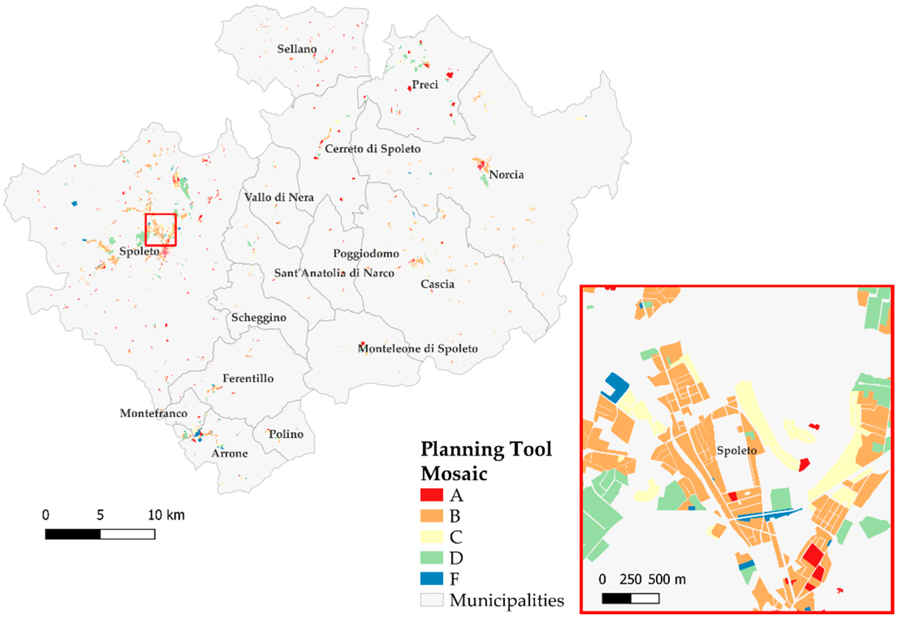
The analysis was conducted using data from different sources. First, a survey of municipal urban plans was carried out considering the 2015–2021 timeframe. The main reason for this research was to verify which municipalities had updated their urban plans following the earthquake in 2016. In this way, it was possible to reconstruct the framework of the transformations planned by the municipalities before and after the earthquake. This allowed verification of the behavior adopted by individual municipalities to respond to the seismic emergency. As already described in previous works [17,18,19], the synoptic descriptions associated with the allowed transformative types are extremely different between the various entities. To analyze the regulatory framework of new urbanization, the mosaic of municipal plans (Planning Tool Mosaic, PTM) was created for the study area (Figure 2). The PTM required the retrieval of plans at the institutional portals of the individual municipalities, a pre-elaboration (georeferencing, digitization, elaboration of the union framework) and the reclassification according to the homogeneous territorial zones defined by Ministerial Decree 2 April 1968, No. 1444. This process involves a certain discretion in the zonal attribution; however, this is a reversible process because the original description of the area is always preserved in the database. The territorial zones are thus defined as:
- (A)
- parts of the territory concerned by urban agglomerations that have a historical, artistic character and of particular environmental value or portions of them, including surrounding areas, which may be considered to be an integral part, for those characteristics, of the agglomerations themselves;
- (B)
- parts of the territory that have been totally or partially built up, other than (A) zones: partially built up are those areas in which the covered area of existing buildings is not less than 12.5% of the buildable area and in which the territorial density exceeds 1.5 m3/m2;
- (C)
- parts of the territory intended for new settlement complexes, which are unbuilt or in which the pre-existing building does not reach the limits of surface area and density referred to in point (B);
- (D)
- parts of the territory intended for new settlements for industrial installations or similar;
- (F)
- parts of the territory intended for equipment and installation of general interest, public spaces, or spaces reserved for collective activities, public green, or parking, with the exclusion of spaces intended for road locations.
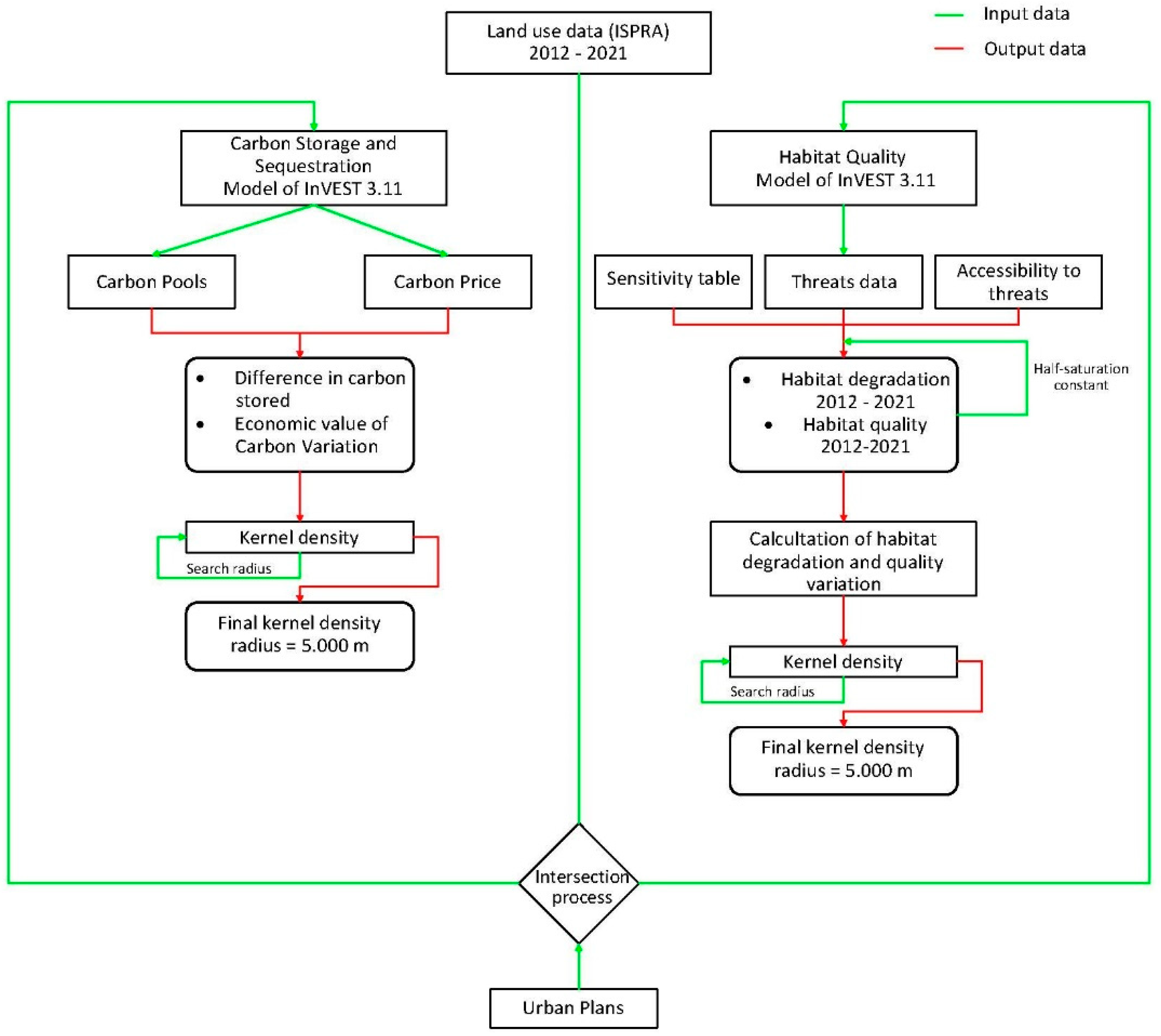
The ecosystem services analysis was conducted through the open-source software InVEST (Integrated Assessment of Ecosystem Services and Tradeoffs) version: “InVEST 3.11.0 Workbench”, which is a suite of models, including that of Carbon Storage and Sequestration (CSS) and that of Habitat Quality (HQ). These two models were used in this study. The methodologies used for the evaluation of models follow the flowchart already tested in other geographical areas [20], and were customized for this work as shown in Figure 3.
The ISPRA (Istituto Superiore per la Protezione e la Ricerca Ambientale) data on land use were used for the assessment of these ecosystem services. The data used can be found at the following link https://www.isprambiente.gov.it/it/banche-dati/banche-dati-folder/suolo-e-territorio/uso-del-suolo (accessed on 15 September 2022). Two years were considered: 2012 (the one closest to the date of the earthquake) and 2021. The geometric resolution of the data is 10 m/pixel. The analysis of the amount of carbon stored was carried out using the Carbon Storage and Sequestration model. The model (based on the IPCC guidelines [21]) requires four types of carbon pools: epigeal biomass, hypogeal biomass, soil and dead organic matter. Input data for land use were derived from the SimulSoil database using the different sources [22,23,24] and adjusting the legend to the one in the ISPRA land cover data. SimulSoil is a computer application that allows to perform balances of ecosystem functions of the territory. The tool allows downloading a land use data package at the national level [25].
The economic value of the seized carbon (expressed in EUR/ton) was derived from Trading Economics (carbon price from the ETS (Emission Trading Systems) market on 15 September 2022 https://tradingeconomics.com/commodity/carbon (accessed on 15 September 2022). Moreover, the assessment of habitat quality input data refers to the same two chrono sections as previously indicated, using the SimulSoil database for the adaptation of the legends for inclusion in the relevant InVEST model. Parameters relating to habitat suitability and threats present in the investigated territory were also included in the input [20].
The sensitivity of the habitat to the threats considers the interferences of the anthropized system and the agricultural areas, and therefore is classified as follows:
Urban: codes 3 and 4 of the ISPRA legend (Table 1), both for the 2012 scenario and for the 2021 scenario;
Agricultural: codes 11, 12, 13, 14, 16 ISPRA legend (Table 1), both for the 2012 scenario and for the 2021 scenario.
For this type of model, a buffer of 1 km was made on the boundary of the study area; in this way, it is possible to consider the edge effect caused by Habitat Quality in the model of InVEST. Edge effects refer to changes in the biological and physical conditions that occur at a patch boundary and within adjacent patches. The identification of the hotspots and coldspots related to the losses of ecosystem services investigated in output to the InVEST model was evaluated through the Kernel analysis with a bandwidth of 5000 m. This distance results from an iterative process aimed at identifying the distance at which such concentrations emerge clearly. We used the QGIS v.3.16 tool “Kernel Density Estimation” choosing as Kernel shape “Epanechnikov”.
4. Results
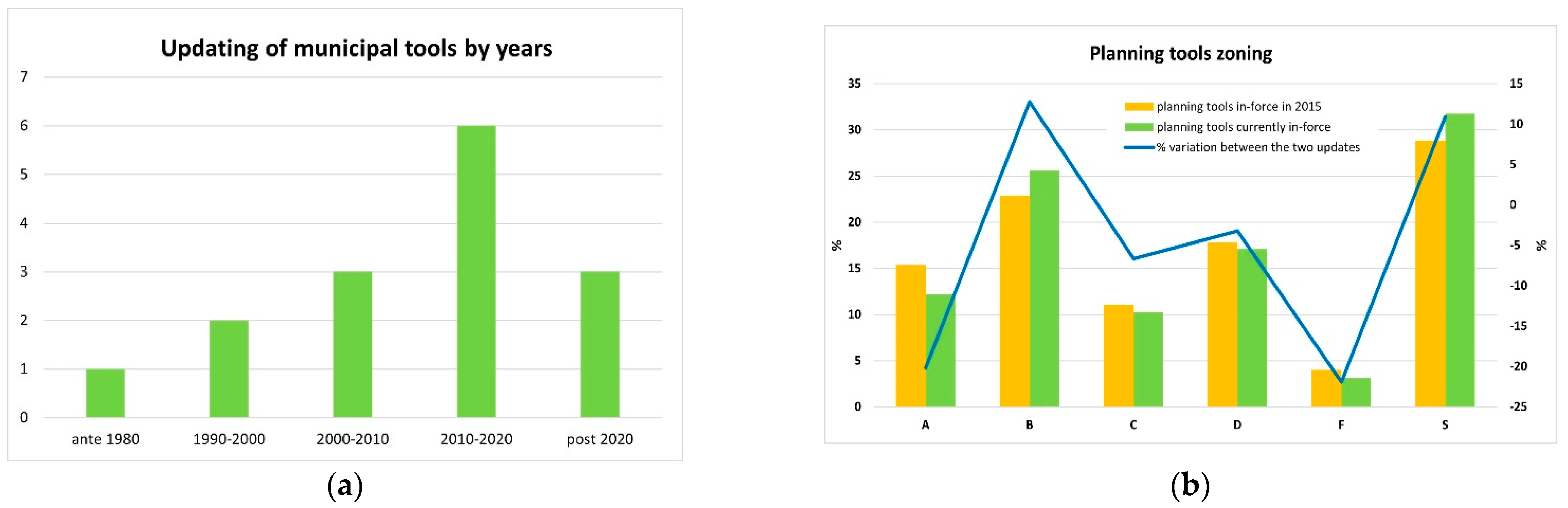
As shown in Figure 4a, 9 of the 15 municipalities analyzed have an urban plan that was updated after 2010, of which 7 updated their instrument after the earthquake of 2016. The analysis was carried out by studying changes in urban plans and their effects on the territory in terms of the loss of ability to provide the ecosystem services previously mentioned. The updated plans, when compared with the previous ones, show an increase in areas destined for urban completion, together with those destined for services (Figure 4b). For the same period, the demographic trend analysis reveals a demographic decline for all the municipalities. This phenomenon is typical of the Italian inland areas and it is now accentuated by the recent earthquakes. On the other hand, the excessive oversize of the transformative forecasts of the plans emerges. In fact, despite the demographic decline, the sizing of the plans is widened. Their full implementation would have significant effects on the environmental system.
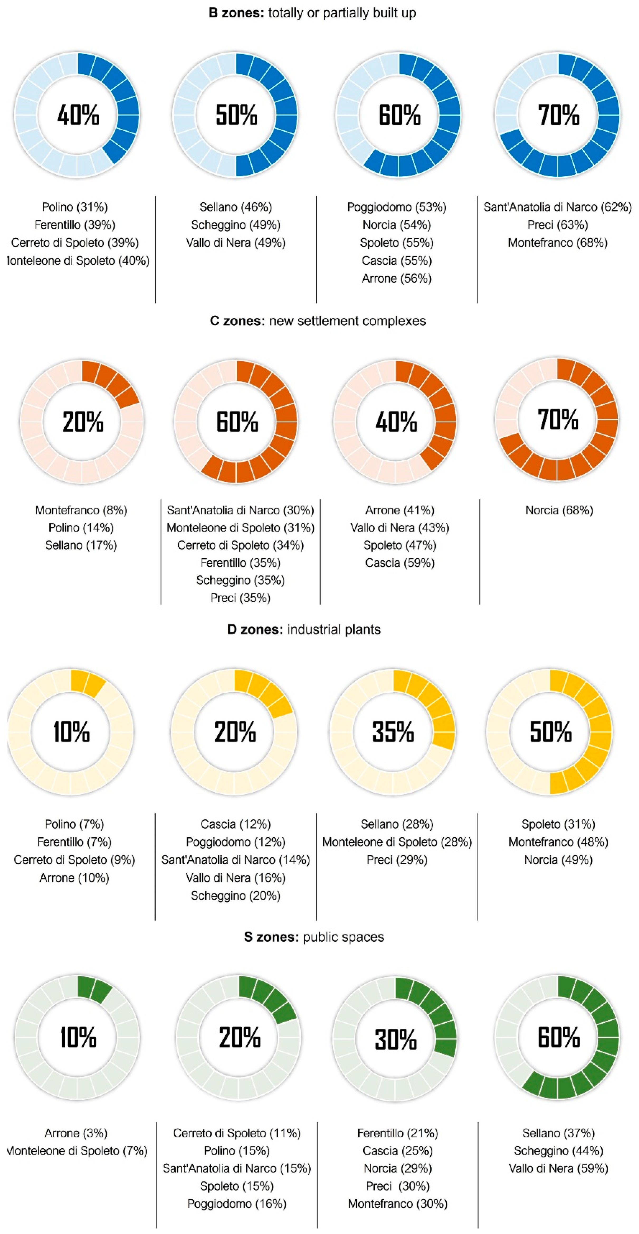
Moreover, many of these predictions are still out of date. As shown in Figure 5, planned but not yet urbanized areas of most municipalities are very high. Residential areas (zones B and C) in most of the analyzed territories do not exceed 50% of the implemented areas. Lower percentages are found both for production areas (D zones) and for areas intended for services (S zones).
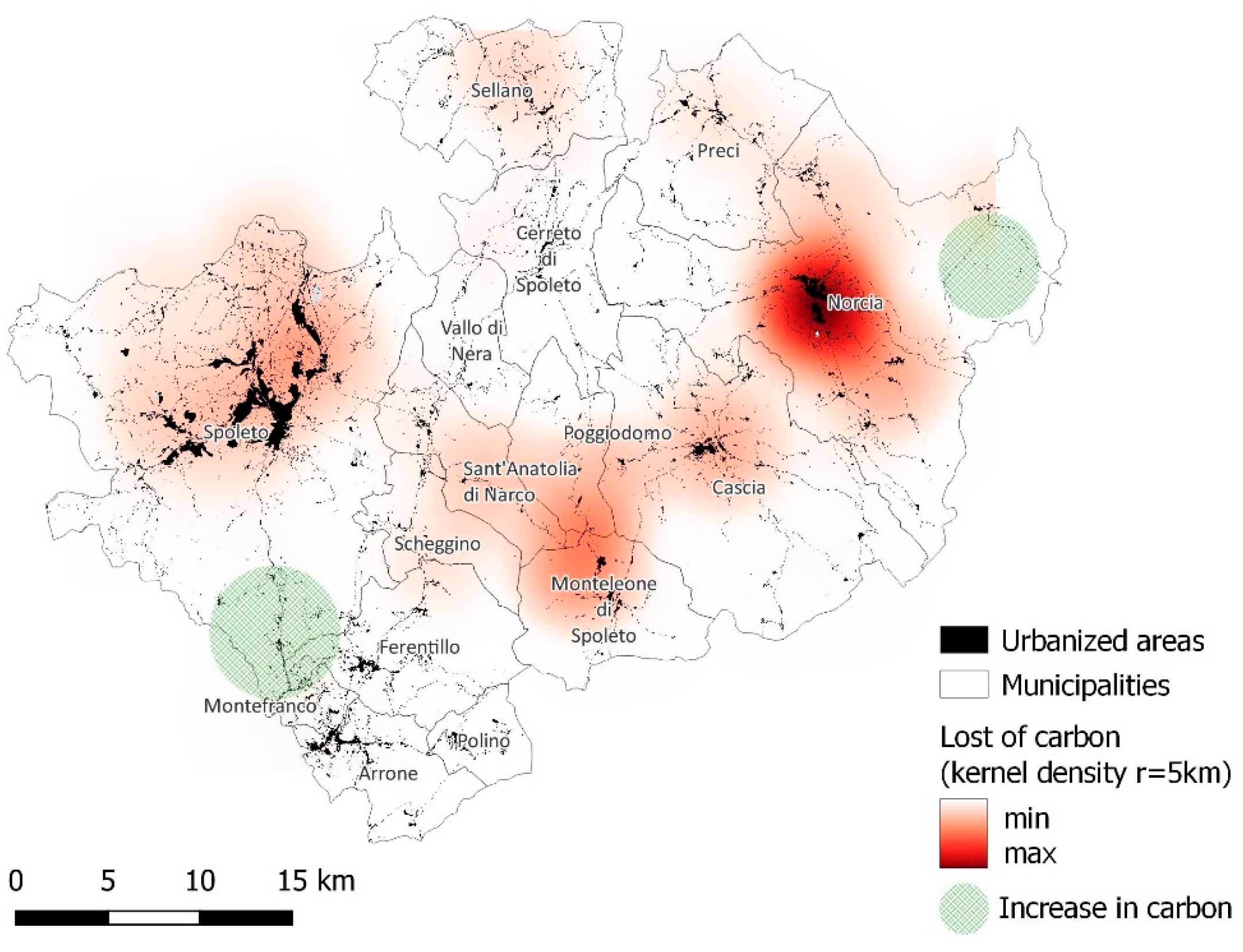
Regarding the assessment of the ecosystem services, the first analysis carried out concerned changes linked to land use changes between 2012 and 2021. This allows both evaluation of the geographical location of the variations (positive and negative) and to understand which were the drivers that led to this new arrangement. The lack of carbon sink amounts to about 950 Mg, and is more concentrated in the municipality of Norcia, and in the municipality of Monteleone di Spoleto (Figure 6). In the latter case, these are losses linked to changes in land use that are not particularly linked to the urbanization processes resulting from the earthquake but rather to different types of use. In the case of the municipality of Norcia, as shown in Figure 7 the aspects related to the first response to the housing emergency have played a major role in the loss of the ability of the soils to store carbon. Moreover, in the municipality of Norcia, and in particular in the territory bordering the Marche and Lazio Regions, the abandonment of some agricultural areas has led to an increase in the capacity of these soils to store carbon (in green in Figure 6). The same condition was found in the territories between the municipalities of Montefranco and Spoleto. In economic terms, the total loss of these changes amounts to around 8000 EUR/y.
As previously mentioned, in this work, the effects of plan choices on two ecosystem services are highlighted. Specifically, the scenarios obtained from the urban forecasts of the pre- and post-earthquake plans are compared. Using InVEST models shows that the capacity to store carbon in 2021 was over 16 million Mg of carbon. The hypothetical scenario derived from the implementation of the settlement forecasts, contained in the plans, was constructed through the overlap of the PTM to land uses of 2021. In other words, it was assumed that the current uses were entirely replaced by urban ones as provided by the plans. The data output of this process was used as data input into InVEST to verify the loss of capacity to store carbon of the soil involved. There was a difference of about 132,000 Mg of carbon equivalent to an economic loss of about EUR 10 million. The municipalities in which the loss of carbon storage is greatest are Spoleto (67,122 Mg), Norcia (14,900 Mg), and Cascia (12,980 Mg). For the municipalities that updated their plans, the 2016 urban forecasts were compared with the ones of 2021. Significant negative variations in carbon storage capacity were detected in the municipalities of Norcia and Poggiodomo. For the municipality of Cascia, the removal of several residential and productive areas has had a positive impact in terms of soil storage capacity.
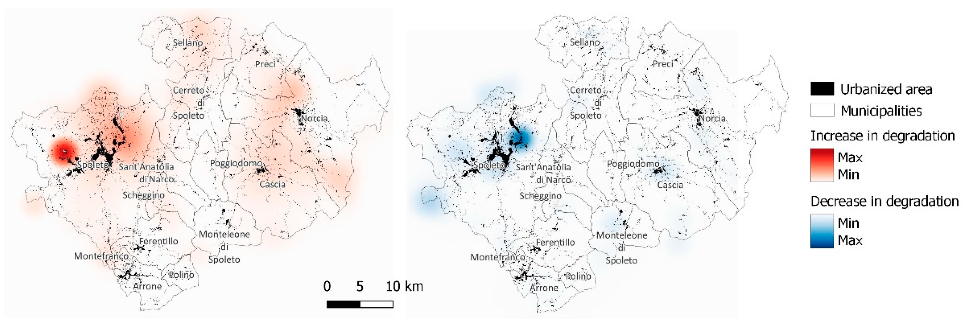
The effects of land use variations on the quality of habitats are shown in Figure 8. Additionally, in this case, a kernel analysis was carried out using a 5000 m bandwidth. A significant increase in degradation of the habitat quality was found in the municipality of Spoleto, specifically in the hamlet of San Giovanni di Baiano and San Martino in Trignano. This phenomenon is mainly due to the increase in agricultural activity with the loss of forest areas. Additionally, in Norcia, the situation was similar but linked to the construction of new urban areas resulting from the earthquake. Conversely, increases in the habitat quality were found in the municipality of Spoleto (hamlets of Cortaccione and Eggi). The reasons for this occurrence are linked to both the increase in forest areas and to changes in crop typologies.
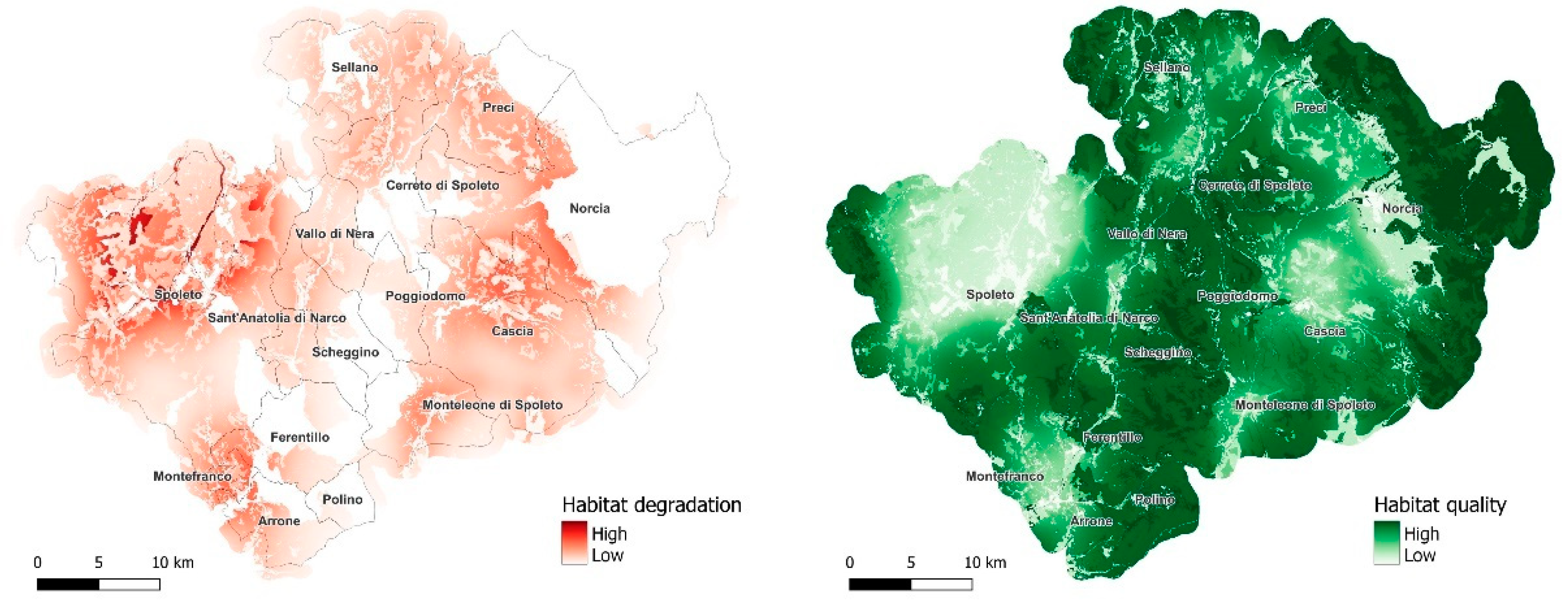
Moreover, this ecosystem service was carried out as an analysis to evaluate the effect of the implementation of the plans’ forecasts. The image in Figure 9 and Table 2 show the results obtained. Currently, more than 22 km2 of the transformative forecasts of the plans remain to be implemented, most of which are intended for services (9.8 km2) and residential use (9.1 km2). The greatest impact in terms of habitat degradation would be in the municipality of Spoleto, which alone concentrates 45% of the areas for residential use not yet implemented and about 60% of those intended for services. The area between the municipalities of Norcia and Cascia, as already highlighted above, could potentially suffer further negative effects linked to the implementation of the forecasts, which, as shown in Table 2, still have outdated percentages higher than 50% of the zonal destinations considered.
Even in the municipality of Preci, there is over 150 ha of land with urban destinations not yet implemented, and that would lead to a depletion in the quality of habitats in an area of high ecological value affected by the Sibillini Mountains National Park. The rugged morphology that marks the border between Umbria and the Marche that affects the municipalities of Norcia and Preci, together with the presence of the National Park, represent the reasons for the high quality of the habitats found in this area.
5. Discussion
This work is part of a research project that analyses the effects of urban change and land use on ecosystem services. Specifically, there are several works that analyze these issues. Nowadays, ecosystem services (ES) mapping is attracting growing interest from landscape and urban planning, but its operationalization in actual decision making is still limited. The mapping of ES capacity, flow, and demand can contribute to the successful integration of the ES approach in landscape and urban planning because it provides a comprehensive picture of the ES delivery process, considering both ecological and social underlying factors [26,27]. The theme of ecosystem services (SE) in support of urban planning practices becomes fundamental for the preliminary assessment of environmental effects and the consequent economic and social consequences of urbanization [28]. The environmental approach to land use planning is mainly referred to in the bureaucratic procedure of plans’ approval rather than the construction of a knowledge system embedded within the strategic environmental assessment procedure. Notably, a great number of skills are required to improve the technical framework for land use sustainability considering its practical application [29]. Urban planning practices should integrate soil quality evaluation procedures to achieve rational urban planning with regard to soil consumption and to ensure less destructive methods with regard to the capacity of the soil to perform its environmental functions. The methods should facilitate effective soil evaluation, and enable planners to recognise the environmental quality of soil, its properties, spatial location, and extent in urban and suburban areas. The outputs of the methods should be developed to the level where they can be easily integrated into existing planning procedures and used in local communities with little adaptation by local experts [27,30].
In this specific case study, the highest limit is linked to the territorial scale. In fact, the study area is small to correctly evaluate some ecosystem services, but, at the same time, it is necessary to work at this scale to fully understand the changes in land use induced by the earthquake. These transformations occurred in a very short time compared to non-emergency periods.
The results of the work clearly show the effects in terms of the loss of the ability of soils to store carbon and those related to changes in habitat quality. The study also quantified the economic damage due to the possible implementation of all the urban planning forecasts, a loss that amounts to about EUR 10 million /y. The consumption of land that occurred in the considered period is linked in large part to the construction of both the S.A.E. concentrated mainly in the municipalities of Norcia, Preci, and Cascia and of private interventions to respond to the housing emergency caused by the earthquake [31]. The laws refer to temporary structures but not to the restoration of the original soil condition at the end of the emergency. This happened also in L’Aquila, after the 2009 earthquake.
As proof of the above, the municipalities that have updated the urban plan after the earthquake of 2016 indicated these areas in the plan as “Aree per la gestione dell’emergenza Sisma 2016” (Regional Law No.8/2018 of the Umbria region), which are areas for the management of the emergency after the earthquake. For these areas, after the emergency, this is preventing the maintenance and recovery of existing buildings, equipment, technological systems, and open spaces during the emergency period. At the end of this phase, however, restoration of the previous conditions is not foreseen, but the predictions of urban reuse are in accordance with what is stated in Art. 26 of the Regional Law No.8/2018 of the Umbria region. In essence, for these areas, the legislation attributes a large panel of possibilities for reuse. These areas could therefore be used for: areas equipped or to be equipped for recreational–tourist–sports use, public facilities, civil protection functions, residential settlements, settlements for activities and services—tourism, sport, leisure, hospitality, reuse of reception equipment—tourism, settlement for activities and services, and areas for any relocation of functions and services. If on the one hand, the pre-existing ecosystem services will barely be recovered, it is true that their geographical position is felt to integrate the existing building fabric. In fact, the S.A.E. are in areas adjacent to the already urbanized territory and this has contained land consumption (e.g.: construction of new ancillary and connecting roads) and made these areas, as mentioned, potentially integrable in the pre-existing urban context.
On the contrary, the criteria used for the localization choices of the interventions in the earthquake of L’Aquila in 2009 did not foresee this possibility at all [32,33] as these are mainly aimed at limiting hydrogeological risk. Moreover, it should be stressed that none of the residential areas (B and C) of the old urban plan (1975) of the capital of the Abruzzo region have been affected by the emergency interventions of public initiatives (project C.A.S.E. and M.A.P. (temporary housing modules)) [34] with the result of creating, in fact, new parts of the cities in areas mainly for agricultural use, without consequent planning of the necessary services. The recovery for many of these areas and their re-functionalization in the urban context, already heavily dispersed, seems extremely difficult and complex [35].
6. Conclusions
This work on the one hand highlights the effects on the environmental system (ecosystem services) linked to the 2016 earthquake emergency, and on the other shows the differences with the L’Aquila earthquake (2009) in terms of urban transformation management. As underlined in this work, these differences require different approaches in view of the restoration/improvement of both the ecosystem services provision and the urban dynamics management. In this sense, the assessment of the ecosystem services before and after the earthquake provides a clear framework of the losses generated by the urban transformations induced by the emergency. In addition, this analysis provides a view of the environmental potential of these territories. An important novelty of the work is that relating to the assessment of the change in the provision of ecosystem services in an area affected by a large-scale calamitous event that triggered a series of social, environmental, and urban changes that in normal conditions would have involved a certainly wider time interval.
Indeed, the earthquake of 2016 that affected the central Italian Apennines profoundly upset the social, urban, and environmental dynamics of the centers involved. The processes of demographical desertification [36,37], already underway in some of the areas investigated, were further intensified, in particular in the hamlets, some of which suffered profound structural damage to the housing stock. Often they were houses used only in particular periods of the year, and for this reason, it is highly unlikely that they will be rebuilt in the near future, mainly because of legislative restrictions.
In these areas, the transformative energies that were in sharp decline left room for the resumption of natural processes and ecosystem services associated with a consequent increase in ecological value. The earthquake of 2016, as often happens in these cases, marked a point break in the existing equilibrium in the area. In the larger municipalities such as Cascia and Norcia, the realization of the S.A.E. has generated new land consumption in the immediate area from before where it was used for agricultural purposes or where the vegetational aspect prevailed.
As mentioned, these areas represent new parts of the future city settlement, which will be strongly integrated into the existing fabric. In the new plan of Norcia, the issue of the containment of land consumption has been one of the objectives and the actions taken move in this direction, favoring the recomposition of the urban margins and limiting the settlement’s dispersion. Moreover, for the municipality of Cascia, the positive effects of both carbon sinks and habitat quality are attributable to the new zoning plan that has essentially removed many of the areas with urban destinations not implemented in the previous instrument.
The same act approved by the Umbria region, with which a specific measure of the Decree-law for the earthquake is implemented (Art. 14 D.L. No. 8 of 9 February 2017, published in the Official Gazette No. 33 of 9 February 2017), provided that the regional authority could buy housing as an alternative measure to the S.A.E., thus encouraging the reuse of existing housing assets not damaged by the earthquake. These buildings then became part of the public housing stock and were used for the public response to the housing emergency. While this issue has nevertheless been addressed in the urban plans approved after 2015 and in the regional measures, none of these focus on ecosystem services. An attempt has been made to provide an immediate response to the housing emergency without considering at the same time the potential loss of eco-systemic services. This work, however, highlights both the effects of the territorial dynamics induced by the earthquake on ecosystem services and the possible loss resulting from the implementation of the transformative predictions present today in the plans. If in the first case, it is not possible to go back, much can be carried out in the second. Many of these plans are oversized in the forecasts and not related to the real demographic dynamics of the territories to which they refer. Re-linking the urban forecast with demographic trends would allow a secure land saving as well as it being in line with target 11.3 of the Agenda 2030 (by 2030 enhance inclusive and sustainable urbanization and capacities for participatory, integrated, and sustainable human settlement planning and management in all countries) [38]. Knowledge of the ecosystem services provided by the soil, together with the current urban planning would allow planners to geographically position the new parts of the built area so as to maximize performance in terms of services and minimize the environmental impacts. It is clear that a limit is linked to the reduced territorial scale of investigation, which could lead to non-exhaustive assessments of the ecosystem services. The future research lines, as also indicated in the LIFE IMAGINE project, intend to extend these assessments to the entire regional territory to provide an overall framework of the environmental potential. This could allow orientation of the future urban plan in an ecosystem, safeguarding the potential of the territories and also in anticipation of future emergencies.
Author Contributions
Conceptualization, F.Z., C.M. and G.D.P.; methodology, C.M. and G.D.P.; software, G.D.P.; validation, F.Z. and C.M.; investigation, C.M. and G.D.P.; data curation, G.D.P.; writing—original draft preparation, C.C. and F.Z.; writing—review and editing, F.Z. and C.M.; visualization, C.M. and C.C. All authors have read and agreed to the published version of the manuscript.
Funding
This research was funded by Integrated Project LIFE IMAGINE UMBRIA (LIFE19 IPE/IT/000015—Integrated MAnagement and Grant Investments for the N2000 NEtwork in Umbria).
Conflicts of Interest
The authors declare no conflict of interest.
References
- Zullo, F.; Marucci, A.; Fiorini, L.; Romano, B. The Italian Apennines between earthquakes, high naturalness and urban growth. Environ. Plan. B Urban Anal. City Sci. 2020, 47, 716–731. [Google Scholar] [CrossRef]
- Console, R.; Vannoli, P.; Falcone, G. Magnitude distribution and clustering properties of the 3-D seismicity in Central Apennines (Italy). Geophys. J. Int. 2023, 233, 2004–2020. [Google Scholar] [CrossRef]
- Romano, B.; Zullo, F.; Fiorini, L.; Ciabò, S.; Marucci, A. Sprinkling: An Approach to Describe Urbanization Dynamics in Italy. Sustainability 2017, 9, 97. [Google Scholar] [CrossRef]
- Domenella, L.; Galasso, M.; Marinelli, G.; Rotondo, F. Planning seismic Inner Areas in Central Italy. Experimental application for the infrastructural project, lifeline and resilient public space in the shrinking territory. Transp. Res. Procedia 2022, 60, 140–147. [Google Scholar] [CrossRef]
- Brando, G.; Pagliaroli, A.; Cocco, G.; Di Buccio, F. Site effects and damage scenarios: The case study of two historic centers following the 2016 Central Italy earthquake. Eng. Geol. 2020, 272, 105647. [Google Scholar] [CrossRef]
- Duan, Y.; Di, B.; Ustin, S.L.; Xu, C.; Xie, Q.; Wu, S.; Li, J.; Zhang, R. Changes in ecosystem services in a montane landscape impacted by major earthquakes: A case study in Wenchuan earthquake-affected area, China. Ecol. Indic. 2021, 126, 107683. [Google Scholar] [CrossRef]
- Cui, P.; Chen, X.-Q.; Zhu, Y.-Y.; Su, F.-H.; Wei, F.-Q.; Han, Y.-S.; Liu, H.-J.; Zhuang, J.-Q. The Wenchuan Earthquake (12 May 2008), Sichuan Province, China, and resulting geohazards. Nat. Hazards 2011, 56, 19–36. [Google Scholar] [CrossRef]
- Zhang, J.; Hull, V.; Xu, W.; Liu, J.; Ouyang, Z.; Huang, J.; Wang, X.; Li, R. Impact of the 2008 Wenchuan earthquake on biodiversity and giant panda habitat in Wolong Nature Reserve, China. Ecol. Res. 2011, 26, 523–531. [Google Scholar] [CrossRef]
- Wang, Y.K.; Fu, B.; Xu, P. Evaluation the impact of earthquake on ecosystem services. Procedia Environ. Sci. 2012, 13, 954–966. [Google Scholar] [CrossRef]
- Contreras, D.; Blaschke, T.; Kienberger, S.; Zeil, P. Spatial connectivity as a recovery process indicator: The L’Aquila earthquake. Technol. Forecast. Soc. Chang. 2013, 80, 1782–1803. [Google Scholar] [CrossRef]
- Contreras, D.; Forino, G.; Blaschke, T. Measuring the progress of a recovery process after an earthquake: The case of L’Aquila, Italy. Int. J. Disaster Risk Reduct. 2018, 28, 450–464. [Google Scholar] [CrossRef]
- Iannella, M.; Liberatore, L.; Biondi, M. The effects of a sudden urbanization on micromammal communities: A case study of post-earthquake L’Aquila (Abruzzi Region, Italy). Ital. J. Zool. 2016, 83, 255–262. [Google Scholar] [CrossRef]
- Gargiulo, C.; Zoppi, C. Planning, Nature and Ecosystem Services; FedOA-Federico II University Press: Naples, Italy, 2019. [Google Scholar]
- Zoppi, C.; Lai, S. Land-taking processes: An interpretive study concerning an Italian region. Land Use Policy 2014, 36, 369–380. [Google Scholar] [CrossRef]
- Commissario Straordinario Ricostruzione SISMA 2016. Flash Rep” Sisma 2016 3° trim 2019. 2019, p. 340. Available online: https://sisma2016data.it/report/FlashRep_Restyling_A4_full_30_settembre-2.pdf (accessed on 31 October 2022).
- Istat. Statistiche Demografiche. Available online: https://www.istat.it/ (accessed on 31 October 2022).
- Fiorini, L.; Zullo, F.; Marucci, A.; Di Dato, C.; Romano, B. Planning Tool Mosaic (PTM): A Platform for Italy, a Country Without a Strategic Framework. Land 2021, 10, 279. [Google Scholar] [CrossRef]
- Francesco, Z.; Cristina, M.; Chiara, C.; Bernardino, R. Ecological connectivity efficiency: A study for Maiella National Park and Abruzzo, Lazio and Molise National Park. In SUPTM 2022: 1st Conference on Future Challenges in Sustainable Urban Planning & Territorial Management; Universidad Politécnica de Cartagena: Cartagena, Spain, 2022. [Google Scholar] [CrossRef]
- Montaldi, C.; Zullo, F.; Cattani, C.; Di Pietro, G. Effects of urban planning on ecosystem services. The Umbria Region Seismic Crater. In Proceedings of the 4th ESP Ecosystem Services Partnership Europe Regional Conference, Heraklion, Greece, 12 October 2022. [Google Scholar]
- Zullo, F.; Montaldi, C.; Di Pietro, G.; Cattani, C. Land Use Changes and Ecosystem Services: The Case Study of the Abruzzo Region Coastal Strip. ISPRS Int. J. Geo-Inf. 2022, 11, 588. [Google Scholar] [CrossRef]
- Eggleston, H.S. (Ed.) 2006 IPCC Guidelines for National Greenhouse Gas Inventories; Institute for Global Environmental Strategies: Hayama, Japan, 2006. [Google Scholar]
- Di Cosmo, L.; Gasparini, P.; Tabacchi, G. A national-scale, stand-level model to predict total above-ground tree biomass from growing stock volume. For. Ecol. Manag. 2016, 361, 269–276. [Google Scholar] [CrossRef]
- Sallustio, L.; De Toni, A.; Strollo, A.; Di Febbraro, M.; Gissi, E.; Casella, L.; Geneletti, D.; Munafò, M.; Vizzarri, M.; Marchetti, M. Assessing habitat quality in relation to the spatial distribution of protected areas in Italy. J. Environ. Manag. 2017, 201, 129–137. [Google Scholar] [CrossRef]
- Di Fabbio, A.; Di Leginio, M.; Fumanti, F.; Rischia, I. Progetto SIAS—Sviluppo Di Indicatori Ambientali Sul Suolo in Italia; APAT. Available online: https://www.isprambiente.gov.it/files/doc-suoli/14dileginio.pdf (accessed on 22 March 2023).
- Simulsoil. User Guide. Available online: http://www.sam4cp.eu/wp-content/uploads/2018/06/SimulSoil_UserGuide-it.pdf (accessed on 15 February 2023).
- Baró, F.; Palomo, I.; Zulian, G.; Vizcaino, P.; Haase, D.; Gómez-Baggethun, E. Mapping ecosystem service capacity, flow and demand for landscape and urban planning: A case study in the Barcelona metropolitan region. Land Use Policy 2016, 57, 405–417. [Google Scholar] [CrossRef]
- Salata, S.; Giaimo, C. Nuovi paradigmi per la pianificazione urbanistica: I servizi ecosistemici per il buon uso del suolo. In Un Nuovo Ciclo Della Pianificazione Urbanistica Tra Tattica e Strategia; Planum-Publisher: Rome, Italy; Milan, Italy, 2016; pp. 197–202. [Google Scholar]
- Helian, L.; Shilong, W.; Guanglei, J.; Ling, Z. Changes in land use and ecosystem service values in Jinan, China. Energy Procedia 2011, 5, 1109–1115. [Google Scholar] [CrossRef]
- Joint Research Centre, Institute for Energy and Transport; Bertoldi, P. 9th International Conference on Energy Efficiency in Commercial Buildings and Smart Communities; Bertoldi, P., Ed.; Publications Office: Luxembourg, 2016; Available online: https://data.europa.eu/doi/10.2790/290244 (accessed on 22 March 2023).
- Vrščaj, B.; Poggio, L.; Marsan, F.A. A method for soil environmental quality evaluation for management and planning in urban areas. Landsc. Urban Plan. 2008, 88, 81–94. [Google Scholar] [CrossRef]
- Trombadore, A.; Paolini, M. ReCycle Norcia—The metamorphosis of temporary housing solutions via permanence and innovation. TECHNE-J. Technol. Archit. Environ. 2020, 20, 222–235. [Google Scholar] [CrossRef]
- Zullo, F.; Rusci, S. Lo shock sismico al servizio della speculazione: Dinamiche immobiliari e rendita urbana nella città dell’Aquila. Arch. Studi Urbani E Reg. 2021, 129, 137–159. [Google Scholar] [CrossRef]
- Marucci, A.; Fiorini, L.; Zullo, F. L’effetto Delle Politiche Emergeniali Sull’odierno Assetto Della Città Dell’aquila; Franco Angeli: Milan, Italy, 2019. [Google Scholar]
- Sette, C.; Montaldi, C. Riqualificazione urbana e coesione territoriale nelle aree interne italiane. Urban Inf. Plan. 2022; online. [Google Scholar]
- Forino, G. Riflessioni geografiche sul disaster management a L’Aquila. Semest. Studi E Ric. Geogr. 2012, 1. [Google Scholar] [CrossRef]
- Morettini, G. All’ombra dei mille campanili. Dinamiche demografiche di lungo periodo nell’area del cratere sismico del 2016 e 2017. Pop. E Storia 2019, 1, 19–41. [Google Scholar] [CrossRef]
- Ugolini, A.; Conforti, A. A quando ritorneremo e l’orologio sopra la porta ricomincerà a pulsare». Strategie e problemi della ricostruzione nei centri abbandonati delle Marche dopo il sisma del 2016. ArcHistoR 2020, 846–869. [Google Scholar] [CrossRef]
- Calka, B.; Orych, A.; Bielecka, E.; Mozuriunaite, S. The Ratio of the Land Consumption Rate to the Population Growth Rate: A Framework for the Achievement of the Spatiotemporal Pattern in Poland and Lithuania. Remote Sens. 2022, 14, 1074. [Google Scholar] [CrossRef]
Figure 1.
Geographical view of the seismic crater with areas under environmental protection.

Figure 2.
Geographical view of the study area with Planning Tool Mosaic. Detail of PTM on the right.
Figure 2.
Geographical view of the study area with Planning Tool Mosaic. Detail of PTM on the right.

Figure 3.
Flowchart of used analysis methodology.

Figure 4.
Information about municipal urban plans in force in the study area: (a) Updating period of municipal planning tools. (b) Comparison of the territorial zones between municipal urban plans in force before 2015 and currently in force.
Figure 4.
Information about municipal urban plans in force in the study area: (a) Updating period of municipal planning tools. (b) Comparison of the territorial zones between municipal urban plans in force before 2015 and currently in force.

Figure 5.
Geographical view of the study area with Planning Tool Mosaic. Detail of PTM on the right.
Figure 5.
Geographical view of the study area with Planning Tool Mosaic. Detail of PTM on the right.

Figure 6.
Variation in carbon sequestration between 2012 and 2021 in plans of municipalities that updated the urban plans.
Figure 6.
Variation in carbon sequestration between 2012 and 2021 in plans of municipalities that updated the urban plans.

Figure 7.
Comparison between the pre-earthquake and post-earthquake geography of the main urban area of the municipality of Norcia.
Figure 7.
Comparison between the pre-earthquake and post-earthquake geography of the main urban area of the municipality of Norcia.

Figure 8.
Increasing and decreasing changes in habitat quality in the area surveyed between 2012 and 2021. The variations are a function of land use changes.
Figure 8.
Increasing and decreasing changes in habitat quality in the area surveyed between 2012 and 2021. The variations are a function of land use changes.

Figure 9.
Effects on the quality of the habitats linked to the possible implementation of all the settlement forecasts contained in existing municipal urban plans.
Figure 9.
Effects on the quality of the habitats linked to the possible implementation of all the settlement forecasts contained in existing municipal urban plans.


Table 1.
Legend of ISPRA land uses for the study area.
| ISPRA Legend | |
|---|---|
| CODE | Description |
| 2 | Forest use |
| 3 | Quarries and mines |
| 4 | Urban and similar areas |
| 5 | Water uses |
| 11 | Arable crops |
| 12 | Forage |
| 13 | Permanent crops |
| 14 | Agro-forestry areas |
| 16 | Other agricultural uses |
| 61 | Wetland areas |
| 62 | Other non-economic uses |
Table 2.
Total and percentage planning forecasts not yet implemented for each zone type in the municipalities investigated.
Table 2.
Total and percentage planning forecasts not yet implemented for each zone type in the municipalities investigated.
| Municipalities | B + C Zones | D Zones | S Zones | |||
|---|---|---|---|---|---|---|
| Surface (ha) | Planned but Not Urbanized Areas (%) | Surface (ha) | Planned but Not Urbanized Areas (%) | Surface (ha) | Planned but Not Urbanized Areas (%) | |
| Arrone | 75.0 | 52.4 | 26.8 | 52.9 | 48.9 | 77.3 |
| Cascia | 182.8 | 56.7 | 10.1 | 43.0 | 85.3 | 75.0 |
| Cerreto di Spoleto | 65.3 | 68.4 | 10.7 | 67.4 | 41.9 | 88.7 |
| Ferentillo | 50.8 | 63.7 | 11.9 | 69.1 | 10.5 | 70.5 |
| Montefranco | 24.2 | 42.5 | 6.7 | 94.0 | 5.2 | 68.1 |
| Monteleone di Spoleto | 42.5 | 61.4 | 2.0 | 78.4 | 13.4 | 90.6 |
| Norcia | 200.9 | 44.1 | 43.2 | 32.4 | 173.7 | 72.8 |
| Poggiodomo | 15.3 | 53.6 | 0.0 | 0.0 | 7.9 | 84.4 |
| Polino | 19.0 | 76.1 | 5.3 | 89.3 | 2.4 | 88.4 |
| Preci | 110.0 | 67.8 | 100.2 | 77.1 | 1.6 | 72.0 |
| Sant’Anatolia di Narco | 20.9 | 57.1 | 12.0 | 72.8 | 31.1 | 84.8 |
| Scheggino | 10.6 | 64.4 | 5.0 | 64.8 | 11.9 | 57.1 |
| Sellano | 66.9 | 47.6 | 6.0 | 83.1 | 44.3 | 62.5 |
| Spoleto | 795.6 | 51.4 | 363.6 | 53.9 | 754.4 | 83.2 |
| Vallo di Nera | 22.0 | 60.6 | 3.0 | 54.6 | 3.0 | 48.9 |
| Total | 1701.8 | 53.8 | 606.5 | 58.1 | 1235.7 | 80.0 |
Disclaimer/Publisher’s Note: The statements, opinions and data contained in all publications are solely those of the individual author(s) and contributor(s) and not of MDPI and/or the editor(s). MDPI and/or the editor(s) disclaim responsibility for any injury to people or property resulting from any ideas, methods, instructions or products referred to in the content. |
© 2023 by the authors. Licensee MDPI, Basel, Switzerland. This article is an open access article distributed under the terms and conditions of the Creative Commons Attribution (CC BY) license (https://creativecommons.org/licenses/by/4.0/).
Share and Cite
MDPI and ACS Style
Cattani, C.; Montaldi, C.; Di Pietro, G.; Zullo, F. Effects of Urban Planning on Ecosystem Services: The Umbria Region Seismic Crater. Sustainability 2023, 15, 7674. https://doi.org/10.3390/su15097674
AMA Style
Cattani C, Montaldi C, Di Pietro G, Zullo F. Effects of Urban Planning on Ecosystem Services: The Umbria Region Seismic Crater. Sustainability. 2023; 15(9):7674. https://doi.org/10.3390/su15097674
Chicago/Turabian StyleCattani, Chiara, Cristina Montaldi, Gianni Di Pietro, and Francesco Zullo. 2023. "Effects of Urban Planning on Ecosystem Services: The Umbria Region Seismic Crater" Sustainability 15, no. 9: 7674. https://doi.org/10.3390/su15097674
Note that from the first issue of 2016, this journal uses article numbers instead of page numbers. See further details here.