Article

Two-Scaled Identification of Landscape Character Types and Areas: A Case Study of the Yunnan–Vietnam Railway (Yunnan Section), China

1
College of Landscape Architecture and Horticulture Sciences, Southwest Forestry University, Kunming 650224, China
2
College of Biodiversity and Conservation, Southwest Forestry University, Kunming 650224, China
*
Authors to whom correspondence should be addressed.
Sustainability 2023, 15(7), 6173; https://doi.org/10.3390/su15076173
Submission received: 3 February 2023 / Revised: 19 March 2023 / Accepted: 31 March 2023 / Published: 3 April 2023
(This article belongs to the Topic Sustainability in Heritage and Urban Planning)

Abstract

:
In recent decades, the role of heritage railways has gradually shifted from transportation, economy, and trade to tourism, culture, and ecology. The heritage railway landscape is experiencing multiple changes along with a value ambiguity problem. There is a need to comprehensively recognize this landscape in order to promote the transformations and monitor the changes. Inspired by Landscape Character Assessment (LCA), this paper adopts a two-scaled identification framework of landscape character types and areas of the Yunnan–Vietnam Railway (Yunnan section) by integrating holistic and parametric methods. At the regional scale, the landscape character was divided by five natural variables: landform, vegetation, hydrology, soil, and geology. At the corridor scale, the landscape character was classified by five natural and cultural variables: altitude, slope, aspect, land use, and heritage density. At these two scales, k-prototype cluster analysis and multiresolution segmentation (MRS) tool were used to identify landscape character types and areas. The results showed that there were 11 different landscape character types and 80 landscape character areas at the regional scale, and 12 different landscape character types and 58 landscape character areas at the corridor scale. Furthermore, the composition, area, and distribution of these landscape character types and areas were described. The results of this study can form a database for planning, management, and evaluation of the railway.

1. Introduction

Heritage railways have played an important role in history from the first advent of steam trains in the world [1]. Today, most are in poor repair and unable to compete with road transport due to their inefficiency and slowness [2]. Through travel literature and other advertisements, people have begun to accept railways as a daily mode of transportation, and the appeal of such railways is growing. The heritage railway tourism industry has recently seen a resurgence of interest in travel by historic train [3,4]. Moreover, in many countries around the world, heritage railways are being converted into railway museums, greenways, or parks [5,6,7]. Tourism, culture, and ecological values are becoming increasingly important with respect to railways. Management and planning of heritage railways, however, is becoming too heritage-oriented to ignore the railway natural landscape, and there is incomplete understanding of the railway landscape. Landscape can be clearly explained when it is classified by spatial units, which is of great significance for recognition of its abundance and heterogeneity [8]. LCA combines natural and cultural landscapes with people’s perceptions [9,10]; it is a method for recognizing the spatial units that provide a locality its “sense of place” and pinpointing the heterogeneity of adjacent areas [11,12]. Moreover, it can be carried out at many different scales, and provides a framework for the implementation of the European Landscape Convention (ELC) [13,14].
In recent years, landscape character research methods have proliferated. The existing research methods used in the study of landscape character are primarily divided into holistic and parametric methods. Holistic methods tend to be intuitive, descriptive, and expert-oriented [15], and exclude the quantitative indicators of visual perception proposed in recent studies [16]. Parametric methods, on the other hand, tend to overlay or combine maps of different topics into a new comprehensive map [17]. The growth of open digital resources and the advancement of statistical methods have greatly promoted the development of parametric methods. ArcGIS overlay analysis of thematic maps, statistical analysis, or a combination of these two analyses are universally utilized [18,19]. Although relatively objective, parametric methods are highly dependent on the selection of the data, and are limited by differences in data sources, time, resolution, and scale [20,21,22]. When using this approach, it is important to capture, sort, and combine the available data sources [23,24]. Using a single method to study landscape characteristics is not suitable for all locations, and the integration of multiple methods is an inevitable trend. Inspired by the idea of multi-scale classification for LCA, research frameworks that integrate holistic and parametric approaches are beginning to emerge [25]. Yang and Gao adopted a framework for classifying landscape character types and areas using two-step cluster analysis and the MRS tool [26]. However, this framework does not take into account the correlation of landscape character variables and the mixed attributes of data. In addition, despite its widespread use in rural areas and national parks, LCA has not yet been extended to railway research.
The main objective of this study is to provide a more efficient and flexible LCA framework that can recognize the landscape characteristics of railways. Our specific objectives are: (i) to describe two-scaled identification of landscape character types and areas for the railway by integrating holistic and parametric methods, which can provide a reference for other heritage railway or linear heritage research; and (ii) to identify the natural and cultural characteristics of a heritage railway at two scales in order to provide a basic database for future planning, management, and evaluation.

2. Materials and Methods
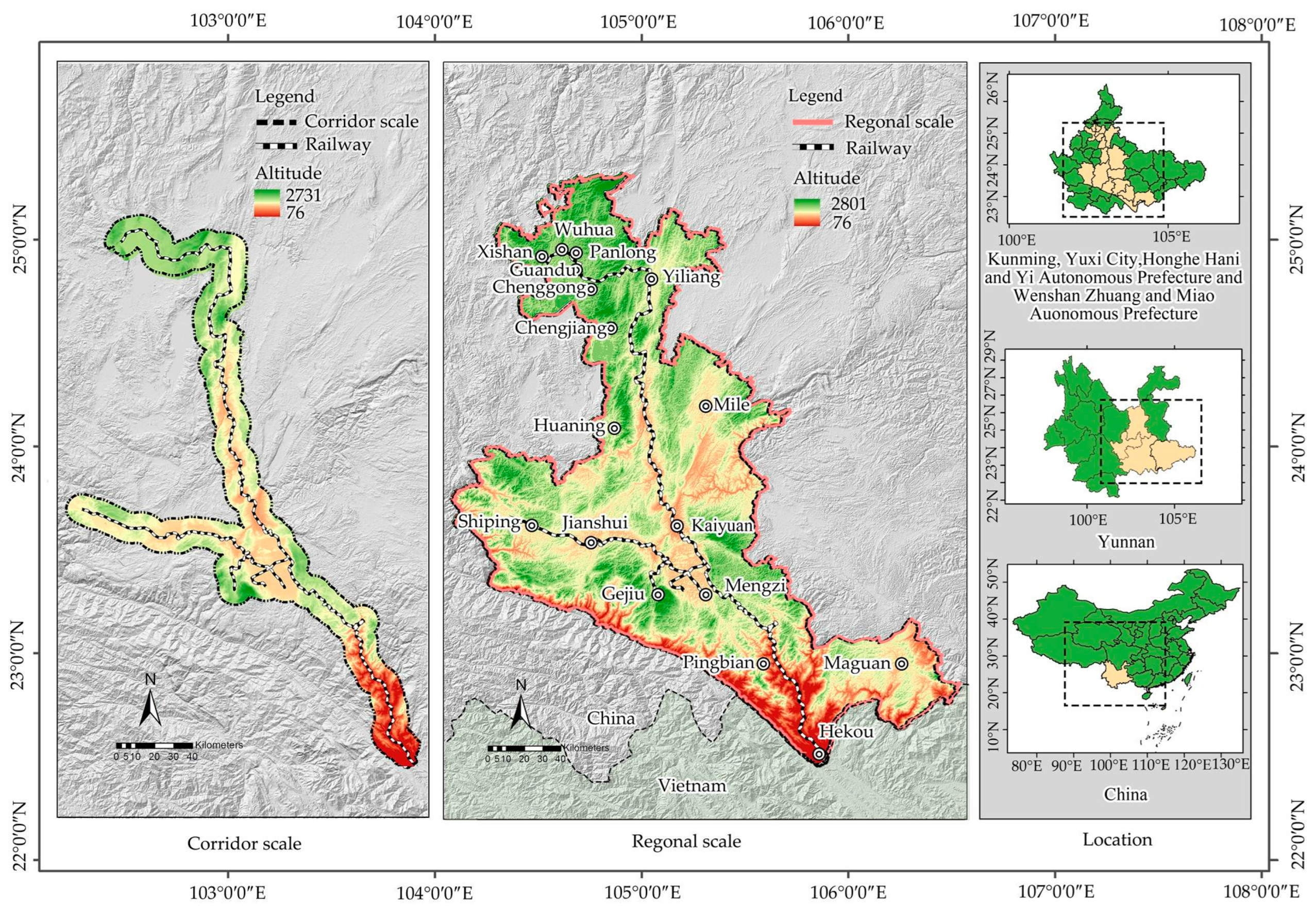
2.1. Study Area

The Yunnan–Vietnam Railway, connecting Haiphong (the largest port city in northern Vietnam) and Kunming (the capital city of Yunnan, China), has a long history of over 120 years. The railway traverses 854 km, of which the Vietnam section (from Haiphong to Laocai) is 389 km and the Yunnan section (from Hekou to Kunming) is 465 km [3]. The Yunnan–Vietnam Railway was the first international alpine narrow-gauge railway in China, and is an outstanding example of Asian alpine narrow-gauge railway technology at the turn of the 20th century. It played an important role in the transformation and economic development of Yunnan and Vietnam. Its name was inscribed on the first edition of the Chinese Industrial Heritage List in 2018 [4]. A rich and heterogeneous landscape, including undulating mountains, natural rivers, plateaus, valleys, and many historical sites, is distributed along the railway. This paper adopted a hierarchical classification framework, and the study area included two-scaled boundaries. At the regional scale, it was made up of 17 counties, districts, and county-level cities along or near the railway. At the corridor scale, it was determined as a 15.8 km-wide linear buffer along the railway, which covered 76.9% of the total resource points (Figure 1).

2.2. Selection of the Variables and Data Sources at Two Scales

At the regional scale (using 1 km × 1 km grid cells and 30 m spatial resolution), the landscape character was divided by five variables (landform, vegetation, hydrology, soil, and geology) to explore the natural features of the railway on a large scale. The five variables were graded into 45 landscape indicators, and the first letters of the variables were used as capitalized acronyms to represent these landscape indicators (Table 1). The correlation tests between the variables were conducted before clustering as the correlation could affect the clustering results [27]. Chi-squared and Lambda tests were used to determine the correlation of the five categorical variables, which were relatively independent for their low correlation. The Digital Elevation Model (DEM, ASTER GDEM 30M) was obtained from the Geospatial Data Cloud website (http://www.gscloud.cn/search, accessed on 21 May 2022). The hydrological data were calculated based on the DEM in ArcGIS. The soil and vegetation datasets were collected from the Institute of Soil Science, Chinese Academy of Sciences. The data on landforms (2016, 1:2,700,000) and geology (2014, 1:2,700,000) were obtained from the China Geological Survey website (https://www.cgs.gov.cn/, accessed on 5 June 2022).
At the corridor scale (using 0.5 km × 0.5 km grid cells and 12.5 m spatial resolution), we focused on the natural and cultural features of the railway and its surrounding environment. The landscape character was classified by six variables: altitude, relief, slope, aspect, land use, and heritage density. Pearson analysis was used to analyze the correlations of five continuous variables. The correlation coefficient between slope and relief was 0.974, showing high correlation. Considering its influence on railway landscape character, the relief variable was excluded. Finally, five variables were selected and divided into 24 indicators, which were coded with Greek alphabet characters such as α and β (Table 2). The DEM data (ALOS 12.5 M DEM) were obtained from the Alaska Satellite Facility website (ASF, https://search.asf.alaska.edu/, accessed on 3 June 2022). The datasets for slope and aspect were calculated based on the DEM. Sentinel-2 data (10 m resolution) from the United States Geological Survey website (USGS, https://earthexplorer.usgs.gov/, accessed on 2 June 2022) were used. The data on land use were calculated based on the Sentinel-2 data in ENVI. There were 300 heritage sites identified along the railway, involving industrial railway heritage, Chinese traditional villages, and various national scenic and historic areas. Heritage density was calculated using 1 km × 1 km grid cells.

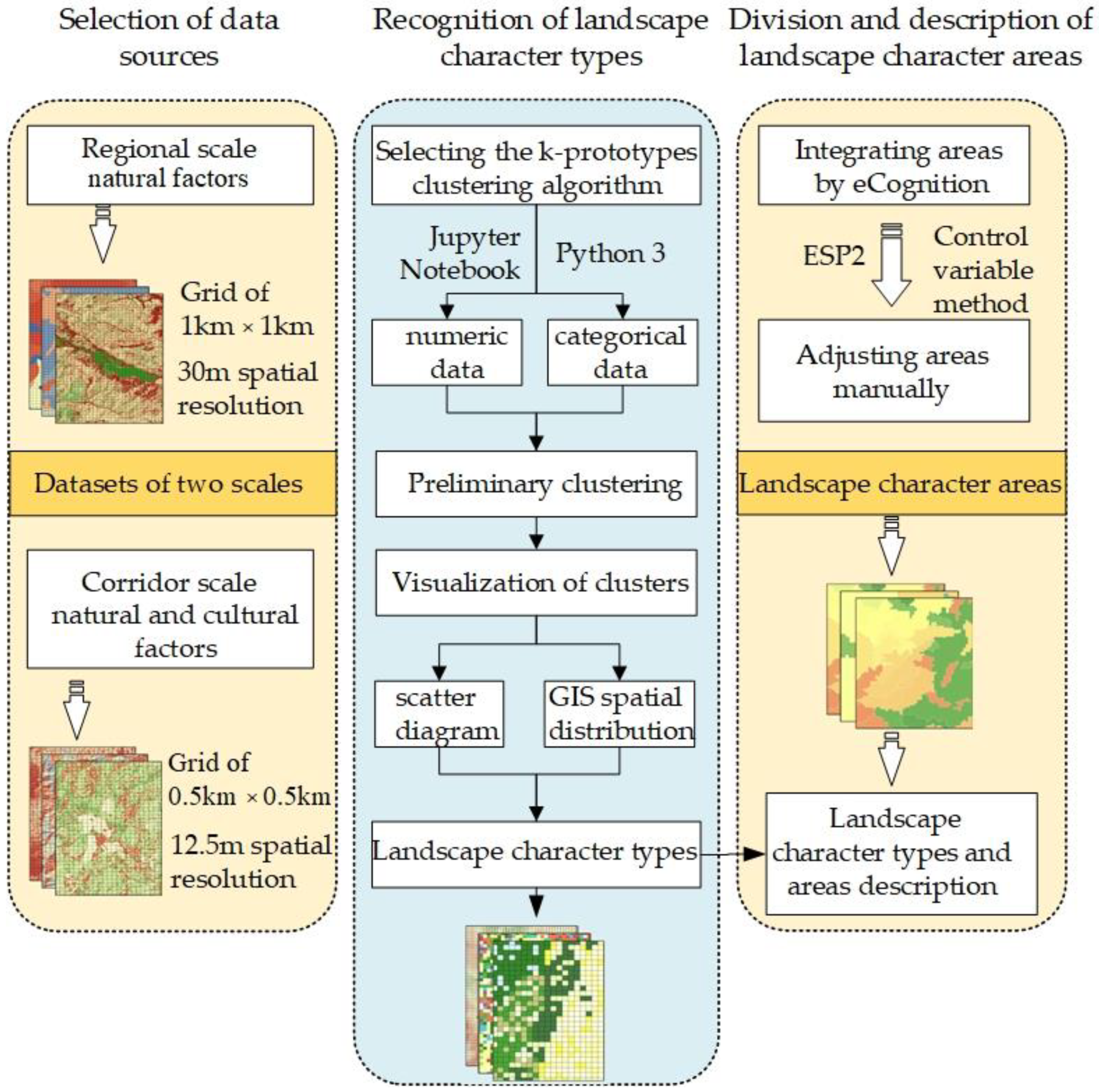
2.3. Analysis Methods

This paper adopted a methodological framework combining the holistic and parametric approaches. The framework primarily included three-stage process: (a) selection of data sources; (b) recognition of landscape character types; and (c) division and description of landscape character areas (Figure 2).
First, all the data variables were entered into ArcGIS in order to unify the coordinate system, spatial resolution, and grid cells at each scale. A 30 m spatial resolution and 1 km × 1 km grid cells were selected for the regional scale, while 12.5 m spatial resolution and 0.5 km × 0.5 km grid cells were selected for the corridor scale. All variables were divided into grid cells in order to establish a matrix that connected the variables and the grid cells through extracted multi-values to point and spatial join tools. In this way, it was ensured that each grid cell had unique corresponding landscape indicators. For example, one grid cell at the regional scale could consist of the indicators L3, V5, H7, S4, and G3. The connection matrix at the two scales was imported into SPSS25. Standardized processing and correlation analysis were performed to eliminate the influence of dimensionality and ensure the independence of the variables.
Second, the data matrix was imported into the Jupyter Notebook platform and the Python programming language was used to program the k-prototypes clustering algorithm. The landscape character types were classified by scatter plots and spatial distribution of clusters. The landscape character types were represented by landscape indicator codes; when a ratio of landscape indicator to landscape character type X accounted for more than 60%, it was indicated as “X”, as “{X}” for a ratio between 30% and 60%, and as “(X)” for a ratio between 10% and 30%. When a ratio accounted for less than 10%, it was not represented. The purpose of clustering is to divide a set of data objects into multiple clusters in such a way that the data objects in one cluster are more similar than those in the other clusters [28,29]. The initial prototype of the k-prototypes algorithm was a k-means algorithm, which was primarily used to analyze numerical data. Then, the k-modes algorithm was extended to a k-means algorithm to deal with categorical data [30]. The k-prototypes algorithm integrates the k-means and k-modes algorithms, which can be applied to analyze numerical and categorical mixed data [31,32]. In this paper, we selected the k-prototypes clustering algorithm as a parameterized method for identifying landscape character types by fully considering the mixed attributes of landscape variables. The objective function is as follows [33]:
E = i = 1 n j = 1 k w i j d x i , u j
where w i l is an element of the partition matrix, W n × k . x i ( i = 1 , n ) are the objects in the dataset, u j (j = 1…k) are the prototype observations or the representative vectors for clusters, and d ( x i , u j ) is the degree of dissimilarity, defined below:
  d x i , u j = m = 1 q ( x i m u j m ) + γ j = p + 1 m δ ( x i m , u j m )  
where the first term is the squared Euclidean distance for the numerical variables and the second term is the simple matching dissimilarity for categorical attributes. Here, γ is the weight for categorical attributes, and the simple matching dissimilarity is
δ ( a , b ) = 0                 a = b 1                 a b
Finally, the landscape character areas were delimited by multiresolution segmentation (MRS) and manual delineation. MRS is a bottom-up region merging technique that is commonly used for the classification of objects; it has frequently been applied to image processing and classification [34]. The control variable method was used to set the MRS parameters. We first set the scale and compactness parameters to 100 and 0.5, then successively tested the segmentation effect of shape parameters from 0 to 0.9 to determine the best shape parameter a). Then, the scale parameter and shape parameter were set to 100 and a, respectively, and the segmentation effect of the compactness parameters of 0–1 were tested successively to establish the compactness parameter b. After the shape and compactness parameters were established, the scale parameter c was determined by estimating the peak value of the plug-in by estimating the scale parameter (ESP2). In this way, parameters a, b, and c of the segmentation were obtained. As the results were always over-segmented, manual delineation was used to adjust the results.

3. Results

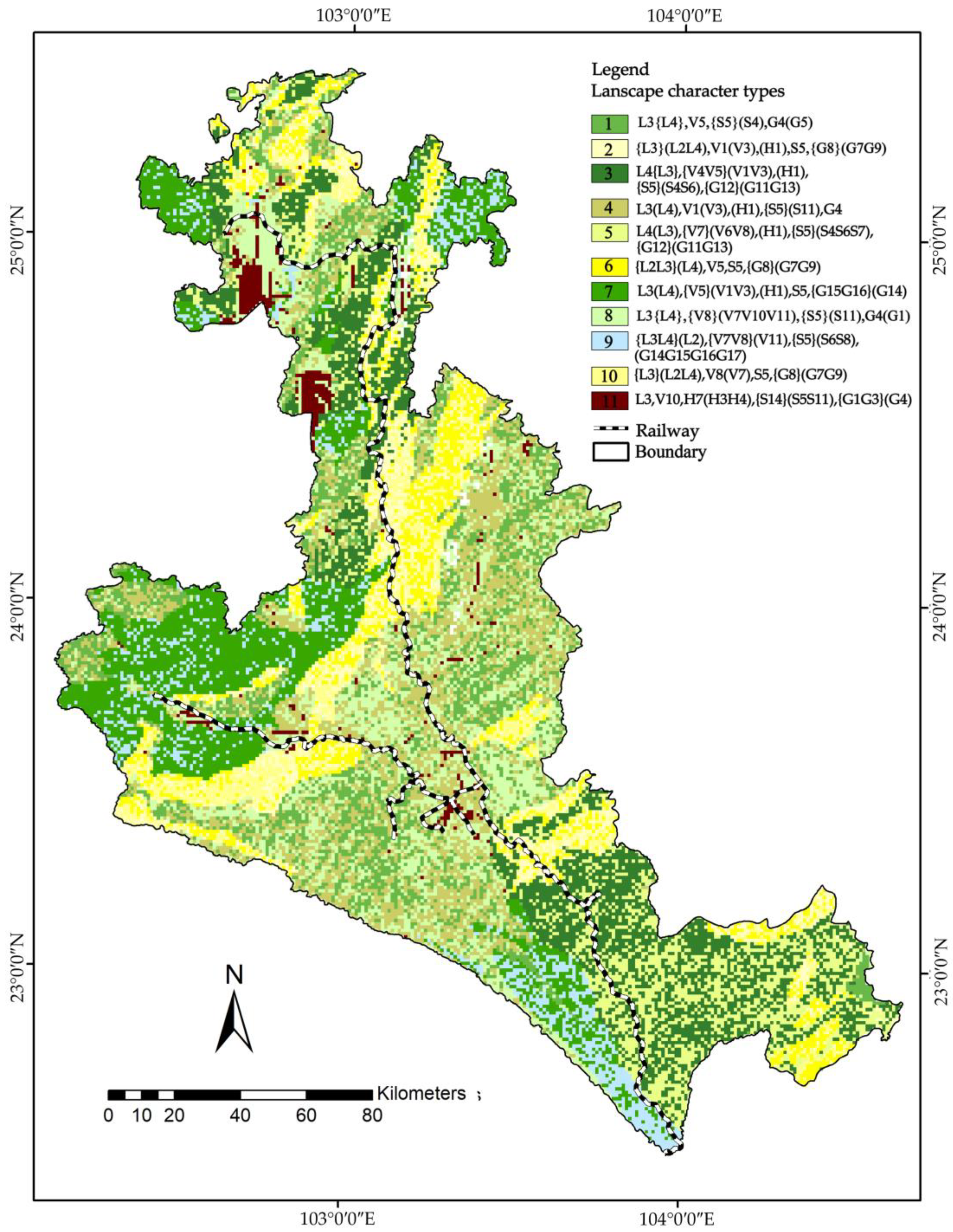
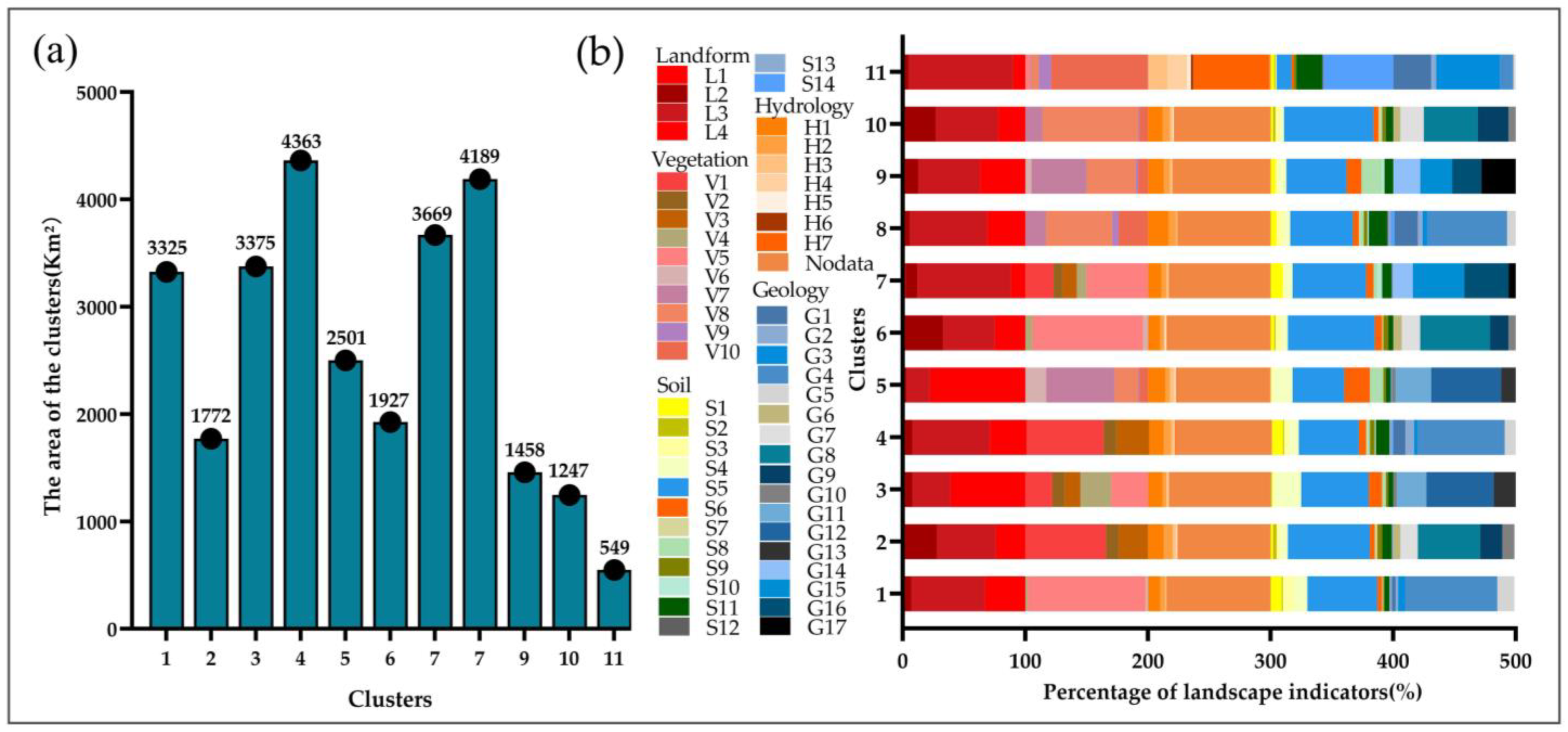
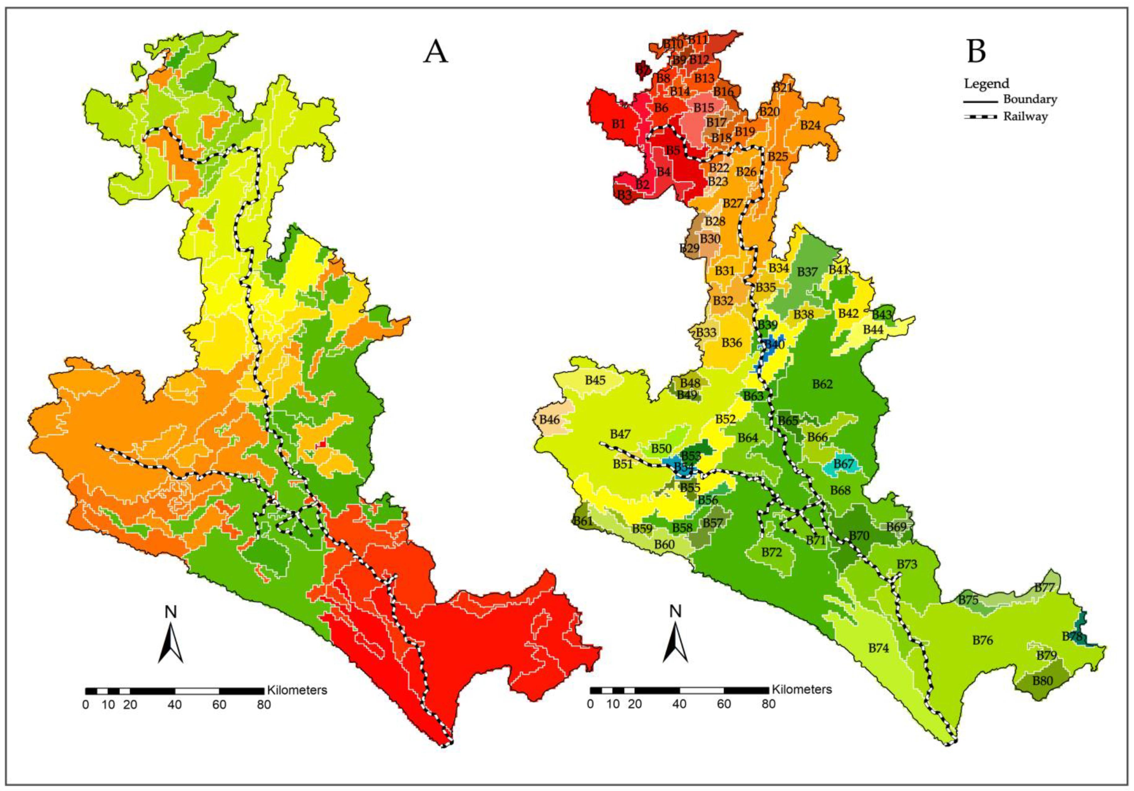
3.1. Landscape Character Types and Areas at the Regional Scale

At the regional scale, five variables for 45 landscape indicators were divided into 30,591 grid cells. Eleven landscape character types were classified by the scatter plots and spatial distribution of clusters (Figure 3). Type 3 covered a maximum area of 4363 km2, type 11 covered a minimum area of 549 km2, and the other clusters covered more than 1000 km2 (Figure 4a). The ratios of the landscape indicators to the landscape character types were expressed by coding as detailed in the materials and methods section. Figure 3 and Figure 4b show that “L3L4, V1V5V8V10, S5, H7 G4” accounted for more than 60% and were prominent characteristics of the types; “{L3L4}, {V4V5V7V8}, {S5S14}, {G1G3G8G12G15G16}” accounted for 30–60% and were typical characteristics; and “(L2L3L4), (V1V3V6V8V7V10V11), (S4S5S6S7S8S11), (G1G4G5G7G9G11G13G14G15G16 G17)” accounted for 10–30% and were general characteristics. The ratios of the landscape indicators to the landscape character types indicated the common feature of the railway that landform was prominent in or features typical of a plateau lake basin subregion or karst middle mountain platform subregion. The vegetation included various types of needleleaf forests in the subtropical zone, as well as grasslands and steppes in both the subtropical and tropical zones. The hydrology was characterized by plateau lakes and natural rivers where the soil was dominated by red earths, while the geology included various typologies of the Triassic system, Cambrian system, Devonian system, Nanhua system, Mesoproterozoic system, Quaternary system, and Jurassic system.
The MRS tool was used to divide the landscape character areas. To ensure the segmentation effect, the scale, shape, and compactness parameters were set to 200, 0.4, and 0.1, respectively. A total of 98 landscape character areas were divided in eCognition (Figure 5A). Then, 80 landscape character areas were divided after manual adjustment (Figure 5B). The distribution of the landscape character areas in Kunming City and Yuxi City was relatively compact, while the distribution of the areas in Honghe Hani and Yi Autonomous Prefecture and Wenshan Zhuang and Miao Autonomous Prefecture was relatively sparse. The landscape character areas gradually decreased in number from north to south. The landscape character areas were more distributed when closer to an urban area and vice versa. In order to further identify the landscape character of the Yunnan–Vietnam Railway (Yunnan Section), 26 landscape character areas along the railway were selected to be named and described according to the prominent or typical features of the landscape character types and field survey (Appendix A) (Table 3). All of the 26 landscape character areas contained red earths, which was a highly representative landscape character along the railway. According to the landform statistics, seventeen landscape character areas contained plateau lake basin, three landscape character areas contained karst middle mountain platform, and six landscape character areas contained both plateau lake basin and karst middle mountain platform. According to the geology statistics, nine landscape character areas included the Triassic system, six landscape character areas included the Devonian system, three landscape character areas included the Cambrian system, and the others included mixed landscape indicators. In addition, there were several special areas. For instance, the landscape character areas for B5, B51, B54, and B71 were characterized as having urban and lake features, and B27, B73, B74, and B76 were characterized as having karst middle mountain platform and tropical rain forest, grassland, and shrub features.

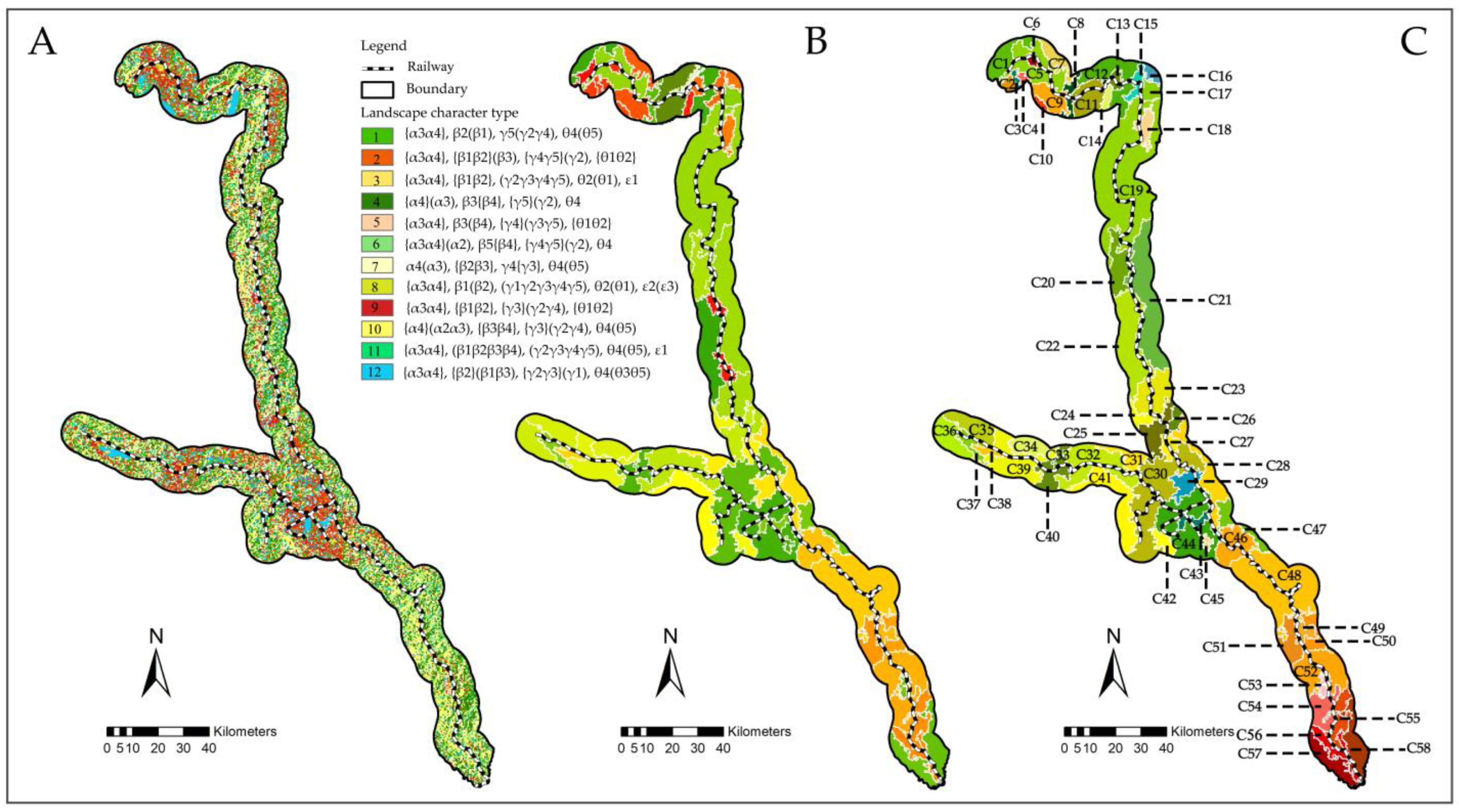
3.2. Landscape Character Types and Areas at the Corridor Scale

At the corridor scale, five variables of the 24 landscape indicators were divided into 35,554 grid cells. Combined with the scatter plots and the spatial distribution of clusters, 12 landscape character types were identified (Figure 6A). Type 6 covered a maximum area of 1224.4 km2 and type 7 covered a minimum area of 17.75 km2 (Figure 7a). Figure 6A and Figure 7b showed that “α4, β1β2β3, γ4γ5, θ2θ4, ε1ε2” were the prominent landscape characteristics of the types, “{α3α4}, {β1β2β3β4}, {γ2γ3γ4γ5}, {θ1θ2}” were typical characteristics, and “(α2α3), (β1β2β3β4), (γ1γ2γ3γ4γ5), (θ1θ2θ3θ5), (ε3)” were the general characteristics (Figure 3). The ratios of the landscape indicators to the landscape character types showed a common feature of the railway, namely, that altitude was prominent in or typical of a middle-high altitude and a high altitude. The slope and aspect were diverse, encompassing flat slope, gentle slope, sunny slope, shady slope, etc. The land use included various types of arable land, built area, and forest land, while the heritage density was characterized by low and medium densities, with zero to four heritage points per square kilometer.
An effective segmentation was received when the parameters for scale, shape, and compactness were set to 100, 0.1, and 0.5, respectively. A total of 63 landscape character areas were divided in eCognition (Figure 6B). Then, 58 landscape character areas were divided after manual adjustment (Figure 6C). The landscape character areas were more distributed when they were closer to an urban area and vice versa. The landscape character areas were named and described by the landscape character types and the field survey (see Appendix B), as shown in Table 4. All of the 58 landscape character areas contained middle–high altitude and high altitude characteristics, which were highly representative landscape characters. Land use was the key variable for dividing the landscape character areas. The five areas containing water landscape characters were located in Dianchi, Fuxian, Yangzonghai, Yilong, and Datunhai Lake; 23 were characterized by forest land, 13 were characterized by arable land and built area types, and the others included mixed types of arable land, forest land, and built area. The landscape character areas for C6, C27, and C45 were characterized by medium- and low-heritage densities, which primarily covered the urban areas of Kunming City and the Kaiyuan and Mengzi County Cities.

4. Discussion

The landscape variables or indicators represent the spatial patterns of the entire landscape mosaic [35]. The classification of the landscape character of the variables (or indicators) by the clustering method can clearly explain the landscape, which is conducive to capturing its abundance and uniqueness [7]. At present, progress has been made in multi-scale research on landscape character. There are large-scale studies using national, regional, and local scales or large, medium, and small scales, regardless of the administrative scales, as well as studies using the region, corridor, and settlement scales [26,36,37]. On the basis of previous studies, in this paper we selected a combination of holistic and parametric methods to divide the two-scaled landscape character of the Yunnan–Vietnam Railway (Yunnan section) by considering the correlations, dimensional differences, and data mixture attributes of the landscape variables.
Our results showed that there 11 landscape character types and 80 landscape character areas at the regional scale and 12 landscape character types and 58 landscape character areas at the corridor scale. Landscape character types and areas were quite diverse in the different areas and scales for the different data sources, clustering methods, and identification modes [38]. For instance, Chongming Island in Shanghai was divided into 6 landscape character types, 18 landscape character sub-types, and 87 landscape character areas [39], while there were 17 landscape character types and 192 landscape character areas in Wuyishan National Park [40].
The landscape character types of the heritage railway were dominated by “L3L4, V1V5V8V10, S5, H7 G4L3, V5, G4” and typical in “{L3L4}, {V4V5V7V8}, {S5S14}, {G1G3G8G12G15G16}”at the regional scale, and were dominated by “α4, β1β2β3, γ4γ5, θ2θ4, ε1ε2” and typical in “{α3α4}, {β1β2β3β4}, {γ2γ3γ4γ5}, {θ1θ2}”at corridor scale. We took the prominent and typical characteristics as the basis for the division and description of landscape character areas, which is similar to previous research [41,42]. The main difference was that we analyzed the general characteristics. In addition, the ratios of the landscape indicators to the variables were closely related to the landscape character types. The higher the ratios, the more likely they were to be prominent or typical landscape types. The ratio of the red earths indicator to the soil variable was 55% at the regional scale and that of the forest land indicator to the land use variable was 58% at the corridor scale, both of which were prominent or typical features in the landscape character types at each scale. This was confirmed by the results of Li’s study on the landscape character of traditional settlements in the Wuling Mountain area at the regional scale [37]. Thus, landscape character types can be used to represent the ratios of the landscape indicators to the variables, which is of great importance for studying the spatial mosaic patterns of linear heritage landscapes and the data mining of resource features.
The spatial distribution of landscape character areas indicated that the landscape character areas were more distributed when closer to an urban area and vice versa. At the regional scale, the distribution of the landscape character areas in Kunming City and Yuxi City was relatively compact, while the distribution of the areas in Honghe Hani and Yi Autonomous Prefecture and Wenshan Zhuang and Miao Autonomous Prefecture was relatively sparse. The landscape character areas gradually decreased in number from north to south. At the corridor scale, the distribution of the landscape character areas in Kunming City, Jianshui County, Mengzi City, Kaiyuan County of Honghe Hani, and Yi Autonomous Prefecture was relatively compact, while the distribution in other areas was sparse. This was mainly because the areas were divided according to landscape character types and field survey. Urban areas contained more landscape types and more diverse combinations. For example, in urban areas there were landscape character areas characterized by water areas, arable land, and built areas, while the natural areas were dominated by forest land at the corridor scale. In addition, the concentration of the heritage railway was primarily in urban areas, which could also be divided into landscape character areas with medium- and low-heritage densities. The distribution of industrial heritage in natural areas was relatively sparse, making it difficult to form a heritage agglomeration area. The spatial distribution features of the landscape character areas could provide basic references for railway revitalization in each administrative region.
The two-scaled identification of landscape character provides a baseline for redefining the complex boundaries of the Yunnan–Vietnam Railway (Yunnan Section) and a framework for better management, planning, and judgement with respect to the landscape. The main limitations of this paper are two-fold: on the one hand, we adopted a top-down method for identifying the landscape character, ignoring public perceptions [43,44,45]; on the other hand, our study did not address landscape decisions. In future research, more detailed hierarchical identification involving public perceptions and landscape decisions should be realized.

5. Conclusions

This paper adopted a two-scaled identification framework of landscape character types and areas along the Yunnan–Vietnam Railway (Yunnan section) by integrating holistic and parametric methods. This framework was able to effectively identify the natural and cultural characteristics of the railway. Due to the flexibility of the method and data sources, it can be applied to other heritage railways or similar linear heritage sites. We identified 11 landscape character types and 80 landscape character areas at the regional scale and 12 landscape character types and 58 landscape character areas at the corridor scale. The identified landscape character types and areas can help in explaining those characteristics that provide a locality with its ‘sense of place’ and pinpointing the heterogeneity of adjacent areas, which is of great significance for landscape management, planning, and evaluation. The indicator composition, area, and distribution of these landscape character types and areas were described. The ratios of the landscape indicators to the variables were closely related to the landscape character types. The higher the ratios, the more likely they were to be prominent or typical landscape types. The spatial distribution of the landscape character areas indicated that they were more distributed when closer to an urban area and vice versa. These analysis results can help planners, managers, and stakeholders to scientifically understand the overall and individual characteristics of the types and distribution rules of areas.

Author Contributions

Conceptualization, Y.W. and J.W.; methodology, Y.W.; software, Y.W.; validation, J.D. and J.K.; formal analysis, C.C.; investigation, Y.W.; resources, M.L.; data curation, C.C.; writing—original draft preparation, Y.W.; writing—review and editing, Y.W.; visualization, Y.W.; supervision, J.W.; project administration, J.W.; funding acquisition, J.W. All authors have read and agreed to the published version of the manuscript.

Funding

This research was funded by the National Natural Science Foundation of China (Project name: Study on Silicon biomineralization in bamboos; project code: 31460169) as well as the Scientific Research Foundation of Yunnan Educational Committee (Project name: Study on the landscape composition of the Yunnan-Vietnam Railway in the context of National Cultural Park; project code: 2022Y613).

Institutional Review Board Statement

Not applicable.

Informed Consent Statement

Not applicable.

Data Availability Statement

All data generated or analyzed during this study are included in the published article.

Acknowledgments

We are grateful to our team for data collection and to the people who gave us directions and explanations in the field.

Conflicts of Interest

The authors declare no conflict of interest.

Appendix A. Field Survey Sheet at the Regional Scale

Sustainability 15 06173 i001

Appendix B. Field Survey Sheet at the Corridor Scale

Sustainability 15 06173 i002

References

  1. Eizaguirre-Iribar, A.; Grijalba, O. A methodological proposal for the analysis of disused railway lines as territorial structuring elements: The case study of the Vasco-Navarro railway. Land Use Policy 2020, 91, 104406. [Google Scholar] [CrossRef]
  2. Quattrone, M.; Tomaselli, G.; D’Emilio, A.; Russo, P. Analysis and evaluation of abandoned railways aimed at greenway conversion: A methodological application in the Sicilian landscape using multi-criteria analysis and geographical information system. J. Agric. Eng. 2018, 49, 151–163. [Google Scholar] [CrossRef] [Green Version]
  3. Li, Q. Development of the Yunnan Section of the Yunnan-Vietnam Railway Heritage Corridor. Arch. Cult. 2011, 8, 100–101. [Google Scholar]
  4. Sang, K.; Fontana, G.L.; Piovan, S.E. Assessing railway landscape by AHP process with GIS: A study of the Yunnan-Vietnam railway. Remote Sens. 2022, 14, 603. [Google Scholar] [CrossRef]
  5. Akbulut, G.; Artvinli, E. Effects of Turkish railway museums on cultural tourism. Procedia. Soc. Behav. Sci. 2011, 19, 131–138. [Google Scholar] [CrossRef] [Green Version]
  6. Rovelli, R.; Senes, G.; Fumagalli, N.; Sacco, J.; De Montis, A. From railways to greenways: A complex index for supporting policymaking and planning. A case study in Piedmont (Italy). Land Use Policy 2020, 99, 104835. [Google Scholar] [CrossRef]
  7. Sim, J.; Miller, P. Understanding an Urban Park through Big Data. Int. J. Environ. Res. Public Health 2019, 16, 3816. [Google Scholar] [CrossRef] [Green Version]
  8. Antrop, M.; Van Eetvelde, V. Holistic aspects of suburban landscapes: Visual image interpretation and landscape metrics. Landsc. Urban Plan. 2000, 50, 43–58. [Google Scholar] [CrossRef]
  9. Bartlett, D.; Gomez-Martin, E.; Milliken, S.; Parmer, D. Introducing landscape character assessment and the ecosystem service approach to India: A case study. Landsc. Urban Plan. 2017, 167, 257–266. [Google Scholar] [CrossRef]
  10. Koblet, O.; Purves, R.S. From online texts to Landscape Character Assessment: Collecting and analyzing first-person landscape perception computationally. Landsc. Urban Plan. 2020, 197, 103757. [Google Scholar] [CrossRef]
  11. Fairclough, G.; Sarlöv Herlin, I.; Swanwick, C. Landscape character approaches in global, disciplinary and policy context: An introduction. In Routledge Handbook of Landscape Character Assessment: Current Approaches to Characterization and Assessment, 2nd ed.; Fairclough, G., Sarlöv Herlin, I., Swanwick, C., Eds.; Routledge: London, UK, 2018; pp. 3–20. [Google Scholar]
  12. Patru-Stupariu, I.; Nita, A. Impacts of the European Landscape Convention on interdisciplinary and transdisciplinary research. Landsc. Ecol. 2022, 37, 1211–1225. [Google Scholar] [CrossRef]
  13. Butler, A. Dynamics of integrating landscape values in landscape character assessment: The hidden dominance of the objective outsider. Landsc. Res. 2016, 41, 239–252. [Google Scholar] [CrossRef] [Green Version]
  14. Hermann, A.; Kuttner, M.; Hainz-Renetzeder, C.; Konkoly-Gyuró, É.; Tirászi, Á.; Brandenburg, C.; Wrbka, T. Assessment framework for landscape services in European cultural landscapes: An Austrian Hungarian case study. Ecol. Indic. 2014, 37, 229–240. [Google Scholar] [CrossRef]
  15. Brabyn, L. Classifying landscape character. Landsc. Res. 2009, 34, 299–321. [Google Scholar] [CrossRef]
  16. Tveit, M.; Ode, A.; Fry, G. Key concepts in a framework for analyzing visual landscape character. Landsc. Res. 2006, 31, 229–255. [Google Scholar] [CrossRef]
  17. Wu, Y.; Wang, H.; Zhang, B. Landscape Character Diversity and Zoning Management: Case of Wuhan Metropolitan Area. J. Urban Plan. Dev. 2021, 147, 04020062. [Google Scholar] [CrossRef]
  18. Karasov, O.; Vieira, A.; Külvik, M.; Chervanyov, I. Landscape coherence revisited: GIS-based mapping in relation to scenic values and preferences estimated with geolocated social media data. Ecol. Indic. 2020, 111, 105973. [Google Scholar] [CrossRef]
  19. Qian, J.; Xiang, W.; Liu, Y.; Meng, X. Incorporating landscape diversity into greenway alignment planning. Urban For. Urban Green. 2018, 35, 45–56. [Google Scholar] [CrossRef]
  20. Chuman, T.; Romportl, D. Multivariate classification analysis of cultural landscapes: An example from the Czech Republic. Landsc. Urban Plan. 2010, 98, 200–209. [Google Scholar] [CrossRef]
  21. Kaminski, A.; Bauer, D.M.; Bell, K.P.; Loftin, S.C.; Nelson, E.K. Using landscape metrics to characterize towns along an urban-rural gradient. Landsc. Ecol. 2021, 36, 1–20. [Google Scholar] [CrossRef]
  22. Antrop, M.; Van Eetvelde, V. Landscape Dynamics and Evolution. In Landscape Perspectives: The Holistic Nature of Landscape; Antrop, M., Van Eetvelde, V., Eds.; Springer: Dordrecht, The Netherlands, 2017; pp. 141–176. ISBN 978-94-024-1183-6. [Google Scholar]
  23. Simensen, T.; Halvorsen, R.; Erikstad, L. Methods for landscape characterization and mapping: A systematic review. Land Use Policy 2018, 75, 557–569. [Google Scholar] [CrossRef]
  24. Cullotta, S.; Barbera, G. Mapping traditional cultural landscapes in the Mediterranean area using a combined multidisciplinary approach: Method and application to Mount Etna (Sicily, Italy). Landsc. Urban Plan. 2011, 100, 98–108. [Google Scholar] [CrossRef]
  25. Van Eetvelde, V.; Antrop, M. A stepwise multi-scaled landscape typology and characterization for trans-regional integration, applied on the federal state of Belgium. Landsc. Urban Plan. 2009, 91, 160–170. [Google Scholar] [CrossRef] [Green Version]
  26. Yang, D.; Gao, C.; Li, L.; Van Eetvelde, V. Multi-scaled identification of landscape character types and areas in Lushan National Park and its fringes, China. Landsc. Urban Plan. 2020, 201, 103844. [Google Scholar] [CrossRef]
  27. Song, Z.; Zhao, Y.; Long, B. A Quantitative method for cultural landscape zoning in traditional Chinese villages and its applications: A case study based on Chongqing. J. South Archit. 2022, 2, 1–10. [Google Scholar]
  28. Li, C.; Wu, X.; Cheng, X.; Fan, C.; Li, Z.; Fang, H.; Shi, C. Identification and analysis of vulnerable populations for malaria based on K-prototypes clustering. Environ. Res. 2019, 176, 10856. [Google Scholar] [CrossRef]
  29. Preud’homme, G.; Duarte, K.; Dalleau, K.; Lacomblez, C.; Bresso, E.; Smaïl-Tabbone, M.; Girerd, N. Head-to-head comparison of clustering methods for heterogeneous data: A simulation-driven benchmark. Sci. Rep. 2021, 11, 4202. [Google Scholar] [CrossRef]
  30. Grané, A.; Albarrán, I.; Lumley, R. Visualizing Inequality in Health and Socioeconomic Wellbeing in the EU: Findings from the SHARE Survey. Int. J. Environ. Res. Public Health 2020, 17, 7747. [Google Scholar] [CrossRef]
  31. Najjar, A.; Reinharz, D.; Girouard, G.; Gagné, C. A two-step approach for mining patient treatment pathways in administrative healthcare databases. Artif. Intell. Med. 2018, 87, 34–48. [Google Scholar] [CrossRef]
  32. Nouraei, H.; Nouraei, H.; Rabkin, S.W. Comparison of Unsupervised Machine Learning Approaches for Cluster Analysis to Define Subgroups of Heart Failure with Preserved Ejection Fraction with Different Outcomes. Bioengineering 2022, 9, 175. [Google Scholar] [CrossRef]
  33. Yin, J.; Gongsang, Q.; Wang, L.; Li, C.; Wu, X. Identification of vulnerable populations and knowledge, attitude, and practice analysis of echinococcosis in Tibet Autonomous Region of China. Environ. Res. 2020, 190, 110061. [Google Scholar] [CrossRef]
  34. Mohan Vamsee, A.; Kamala, P.; Martha, T.R.; Vinod Kumar, K.; Jai Sankar, G.; Amminedu, E. A tool assessing optimal multi-scale image segmentation. J. Indian Soc. Remote Sens. 2018, 46, 31–41. [Google Scholar] [CrossRef]
  35. Li, X.; Yan, P.; Liu, B. Geomorphological classification of aeolian-fluvial interactions in the desert region of north China. J. Arid Environ. 2019, 172, 10421. [Google Scholar] [CrossRef]
  36. Warnock, S.; Griffiths, G. Landscape characterization: The living landscapes approach in the UK. Landsc. Res. 2015, 40, 261–278. [Google Scholar] [CrossRef]
  37. Li, G.; Zhang, B. Identification of landscape character types for trans-regional integration in the Wuling Mountain multi-ethnic area of southwest China. Landsc. Urban Plan. 2017, 162, 25–35. [Google Scholar] [CrossRef]
  38. Atik, M.; Işıklı, R.C.; Ortaçeşme, V.; Yıldırım, E. Exploring a combination objective and subjective assessment in landscape classification: Side case from Turkey. Appl. Geogr. 2017, 83, 130–140. [Google Scholar] [CrossRef]
  39. Ding, D.; Jing, Y.; Wu, Y.; Shi, T. Landscape character assessment of water-land ecotone in an island area for landscape environment promotion. J. Clean. Prod. 2020, 259, 120934. [Google Scholar] [CrossRef]
  40. Yuan, Y.; Zhang, J.; Xu, H.; Zhou, M.; Zhu, L. Study on Landscape Character Identification of Mountain Type National Park: A Case Study of Wuyishan National Park. J. Jiangxi Sci. 2022, 40, 134–139. [Google Scholar]
  41. Koç, A.; Yılmaz, S. Landscape character analysis and assessment at the lower basin-scale. Appl. Geogr. 2020, 125, 102359. [Google Scholar] [CrossRef]
  42. Atik, M.; Işikli, R.C.; Ortaçeşme, V.; Yildirim, E. Definition of landscape character areas and types in Side region, Antalya-Turkey with regard to land use planning. Land Use Policy 2015, 44, 90–100. [Google Scholar] [CrossRef]
  43. Van Eetvelde, V.; Antrop, M. Indicators for assessing changing landscape character of cultural landscapes in Flanders (Belgium). Land Use Policy 2009, 26, 901–910. [Google Scholar] [CrossRef]
  44. Primdahl, J.; Kristensen, L.S. Landscape strategy making and landscape characterization experiences from Danish experimental planning processes. Landsc. Res. 2016, 41, 227–238. [Google Scholar] [CrossRef]
  45. Wartmann, F.M.; Acheson, E.; Purves, R.S. Describing and comparing landscapes using tags, texts, and free lists: An interdisciplinary approach. Int. J. Geogr. Inf. Sci. 2018, 32, 1572–1592. [Google Scholar] [CrossRef] [Green Version]
Figure 1. Location and two-scaled boundaries of the Yunnan–Vietnam Railway (Yunnan section).
Sustainability 15 06173 g001
Figure 2. Methodological framework used to classify landscape character types and areas.
Sustainability 15 06173 g002
Figure 3. Landscape character types at the regional scale.
Sustainability 15 06173 g003
Figure 4. (a) Areas of landscape character types at the regional scale; (b) the ratios of landscape indicators to landscape character types at the regional scale.
Sustainability 15 06173 g004
Figure 5. Landscape character areas at the regional scale: (A) delineation in eCognition; (B) delineation by manual adjustment.
Sustainability 15 06173 g005
Figure 6. Landscape character types and areas at the corridor scale: (A) landscape character types; (B) delineation areas in eCognition; (C) delineation by manual adjustments.
Sustainability 15 06173 g006
Figure 7. (a) Areas of landscape character types at the corridor scale; (b) the ratios of landscape indicators to landscape character types at the corridor scale.
Sustainability 15 06173 g007
Table 1. Variables used for landscape classification at the regional scale.
Variables and Landscape IndicatorsCodesVariables and Landscape IndicatorsCodes
Landform Red earthsS5
Plateau subregionL1Lateritic red earthsS6
Plateau basin subregionL2Torrid red earthsS7
Plateau lake basin subregionL3LatosolsS8
Karst middle mountain platform subregionL4Limestone soilsS9
Vegetation Cinnamon soilsS10
Subtropical and tropical grasslandsV1Paddy soilsS11
Broadleaf evergreen forests in subtropical zoneV2Alluvial soilsS12
Broadleaf deciduous forests in subtropical zoneV3Purplish soilsS13
Tropical rain forestsV4Lake, marshes and urbanS14
Needleleaf forests in subtropical zoneV5Geology
Needleleaf forests in tropical zoneV6Quaternary systemG1
Evergreen and deciduous scrubs in subtropical and tropical zoneV7Neogene systemG2
SteppesV8Jurassic systemG3
Cultivated vegetationV9Triassic systemG4
Lake, marshes and urbanV10Permian systemG5
Hydrology Emeishan basaltsG6
River of 1 levelH1Carboniferous-Permian systemG7
River of 2 levelH2Devonian systemG8
River of 3 levelH3Devonian-carboniferous systemG9
River of 4 levelH4Silurian systemG10
River of 5 levelH5Cambrian-Ordovician systemG11
River of 6 levelH6Cambrian systemG12
LakeH7Paleozoic erathemG13
Soil Sinian systemG14
Brown earthsS1Nanhua systemG15
Dark brown earthsS2Mesoproterozoic erathemG16
Yellow-brown earthsS3Paleoproterozoic erathemG17
Yellow earthsS4
Table 2. Variables used for landscape classification at the corridor scale.
Variables and Landscape
Indicators
CodesVariables and Landscape IndicatorsCodes
Altitude 135–225 (sunny slope)γ4
≤500 m (low altitude)α1225–315 (semi-sunny slope)γ5
500–1000 m (middle altitude)α2Land use
1000–1500 m (middle-high altitude)α3Arable landθ1
>1500 m (high altitude)α4Built areaθ2
Slope Waterθ3
≤5° (flat slope)β1Forest landθ4
5°–15° (gentle slope)Β2Grasslandθ5
15°–25° (ramp slope)Β3Unused landθ6
25°–35° (steep slope)β4Heritage density (number of heritages per 1 km2)
>35° (abrupt slope)β50–2 (low density)ε1
Aspect 2–4 (middle density)ε2
−1 (flat)γ14–6 (middle-high density)ε3
0–45, 315–360 (shady slope)γ2>6 (high density)ε4
45–135 (semi-shady slope)γ3
Table 3. Descriptions of landscape character areas at the regional scale.
AreasTypesDescriptionAreasTypesDescription
B58, 4, 9, 11Urban and lake landscape in plateau lake basin subregion, with Triassic system, red earths, and grassland. B392, 10Steppes and grassland in plateau
lake basin subregion, with Devonian system and red earths.
B68, 6, 2Needleleaf forests and steppes landscape in plateau lake basin subregion, with Triassic system, Devonian system and red earths. B406, 2Needleleaf forests, grassland and steppes landscape in plateau lake basin and middle mountain platform subregion, with Devonian system and red earths.
B19
B32
B62
B64
B68
B72
4, 1, 8Needleleaf forests, grassland and steppes landscape in plateau lake basin subregion, with Triassic system and red earths.B51
B71
11, 4, 8Yilong lake and Datunhai lake landscape in plateau lake basin subregion, with Triassic system, Jurassic system, quaternary system, red earths, grassland, and steppes.
B201, 9Needleleaf forests landscape in plateau lake basin subregion, with Triassic system and red earths.B522, 6, 10Needleleaf forests, grassland, and steppes landscape in plateau lake basin subregion, with Devonian system and red earths.
B25
B35
6, 2, 10Needleleaf forests and grassland landscape in plateau lake basin and middle mountain platform subregion, with Devonian system and red earths.B547, 8, 4, 11Urban, lake landscape and needleleaf forests in plateau lake basin subregion, with Nanhua system, Mesoproterozoic erathem, Triassic system and red earths.
B266, 2, 3Needleleaf forests and grassland landscape in plateau lake basin and middle mountain platform subregion, with Cambrian system and red earths.B634, 2, 6Needleleaf forests and grassland landscape in plateau lake basin subregion, with Devonian system, Triassic system and red earths.
B27
B73
B76
3, 5Tropical rain forest and shrubs landscape in middle mountain platform subregion, with Cambrian system and red earths. B702, 6, 10, 7Needleleaf forests, grassland, and steppes landscape in plateau lake basin subregion, with Devonian system and red earths.
B31
B47
7, 9Needleleaf forests, shrubs and grassland landscape in plateau lake basin and middle mountain platform subregion, with Nanhua system, Mesoproterozoic erathem and red earths.B747, 9, 8Tropical rain forest and shrubs landscape in middle mountain platform and plateau lake basin subregion, with Nanhua system, mesoproterozoic erathem, Triassic system and red earths.
Table 4. Descriptions of landscape character areas at the corridor scale.
AreasTypesDescriptions
C1, C15, C42, C547, 10Forest landscape in high altitude areas, with gentle slope, steep slope, ramp slope, sunny slope and semi-shady slope.
C2, C48, C52, C574, 10, 6Forest landscape in middle-high and high-altitude areas, with ramp slope, steep slope abrupt slope, sunny slope, semi-sunny slope and semi-shady slope.
C3, C10, C14, C38, C4312Water landscape of Dianchi Lake, Fuxian Lake, Yangchuhai Lake, Yilong Lake, Datunhai Lake in middle-high and high-altitude areas, with gentle slope, shady slope and semi-shady slope.
C41, 2, 12Arable, urban, rural and forest landscape in middle-high and high-altitude areas, with flat slope, gentle slope, sunny slope, shady slope, semi-sunny slope and semi-shady slope.
C5, C17,
C18, C33, C37, C40, C44
2, 9Arable, urban and rural landscape in middle-high and high-altitude areas, with flat slope, gentle slope, sunny slope, semi-sunny slope and semi-shady slope.
C63, 8Urban heritage landscape in middle-high and high-altitude areas, with flat slope and gentle slope.
C7, C117, 1, 2Arable, urban, rural and forest landscape in middle-high and high-altitude areas, with flat slope, gentle slope, ramp slope, semi-sunny slope and semi-shady slope.
C81, 2Arable, urban, rural and forest landscape in middle-high and high-altitude areas, with flat slope, gentle slope, sunny slope and semi-sunny slope.
C9, C132, 9, 7Arable, urban, rural and forest landscape in middle-high and high-altitude areas, with flat slope, gentle slope, ramp slope, sunny slope, semi-sunny slope and semi-shady slope.
C12, C1910, 1, 4Forest landscape in middle-high and high-altitude areas, with gentle slope, ramp slope, steep slope, semi-sunny slope and semi-shady slope.
C16, C472, 7Arable, urban, rural and forest landscape in middle-high and high-altitude areas, with flat slope, gentle slope, ramp slope, sunny slope and semi-sunny slope.
C20, C3910, 5, 4Arable, urban, rural and forest landscape in middle-high and high-altitude areas, with ramp slope, steep slope, sunny slope, semi-sunny slope and semi-shady slope.
C217, 1, 4Forest landscape in middle-high and high-altitude areas, with gentle slope, ramp slope, steep slope, semi-sunny slope and semi-shady slope.
C22, C307, 10, 2Arable, urban and rural landscape in middle-high and high-altitude areas, with flat slope, gentle slope, ramp slope, steep slope, sunny slope, semi-sunny slope and semi-shady slope.
C2310, 7, 1Arable, urban, rural and forest landscape in middle-high and high-altitude areas, with flat slope, gentle slope, ramp slope, steep slope, sunny slope, semi-sunny slope and semi-shady slope.
C242, 9, 5Arable, urban and rural landscape in middle-high and high-altitude areas, with flat slope, gentle slope, ramp slope, steep slope, sunny slope, semi-sunny slope and semi-shady slope.
C25, C34, C35, C4110, 7, 4Forest landscape in high-altitude areas, with gentle slope, ramp slope, steep slope, sunny slope, semi-sunny slope and semi-shady slope.
C262, 1, 4,Arable, urban, rural and forest landscape in middle-high and high-altitude areas, with flat slope, gentle slope, ramp slope, steep slope, sunny slope and semi-sunny slope.
C272, 9, 3Arable, urban and rural heritage landscape in middle-high and high-altitude areas, with flat slope, gentle slope, sunny slope, semi-sunny slope and semi-shady slope.
C287, 6, 4Forest landscape in middle-high and high-altitude areas, with gentle slope, ramp slope, steep slope, abrupt slope, sunny slope, semi-sunny slope and semi-shady slope.
C292, 9, 12Arable, urban, rural and forest landscape in middle-high and high-altitude areas, with flat slope, gentle slope, sunny slope, shady slope, semi-sunny slope and semi-shady slope.
C315, 2Arable, urban and rural landscape in middle-high and high-altitude areas, with flat slope, gentle slope, sunny slope and semi-sunny slope.
C32, C467, 1, 12Forest landscape in middle-high and high-altitude areas, with gentle slope, shady slope, semi-sunny slope and semi-shady slope.
C3610, 4, 2Arable, urban, rural and forest landscape in middle-high and high-altitude areas, with flat slope, gentle slope, ramp slope, steep slope, sunny slope, semi-sunny slope and semi-shady slope.
C458, 2Arable, urban and rural heritage landscape in middle-high and high-altitude areas, with flat slope, gentle slope, sunny slope and semi-sunny slope.
C494, 6Arable, urban, rural and forest landscape in middle-high and high-altitude areas, with ramp slope, steep slope, sunny slope and semi-sunny slope.
C506, 7Forest landscape in middle-high and high-altitude areas, with gentle slope, ramp slope, abrupt slope, sunny slope, semi-sunny slope and semi-shady slope.
C5110, 6Forest landscape in middle-high and high-altitude areas, with ramp slope, steep slope, abrupt slope, sunny slope, semi-sunny slope and semi-shady slope.
C535Arable, urban and rural landscape in middle-high and high-altitude areas, with ramp slope and sunny slope.
C554Forest landscape in middle-high and high-altitude areas, with ramp slope, steep slope, shady slope and semi-sunny slope.
C5610Forest landscape in high-altitude areas, with ramp slope, steep slope and semi-sunny slope.
C5810, 7, 6Forest landscape in middle-high and high-altitude areas, with gentle slope, ramp slope, steep slope, abrupt slope, sunny slope, semi-sunny slope and semi-shady slope.
Disclaimer/Publisher’s Note: The statements, opinions and data contained in all publications are solely those of the individual author(s) and contributor(s) and not of MDPI and/or the editor(s). MDPI and/or the editor(s) disclaim responsibility for any injury to people or property resulting from any ideas, methods, instructions or products referred to in the content.

