
Examining the Role of Innovative Streets in Enhancing Urban Mobility and Livability for Sustainable Urban Transition: A Review

Abstract
:1. Introduction
1.1. Background
1.2. Definitions of Innovative Streets
2. Material and Methods
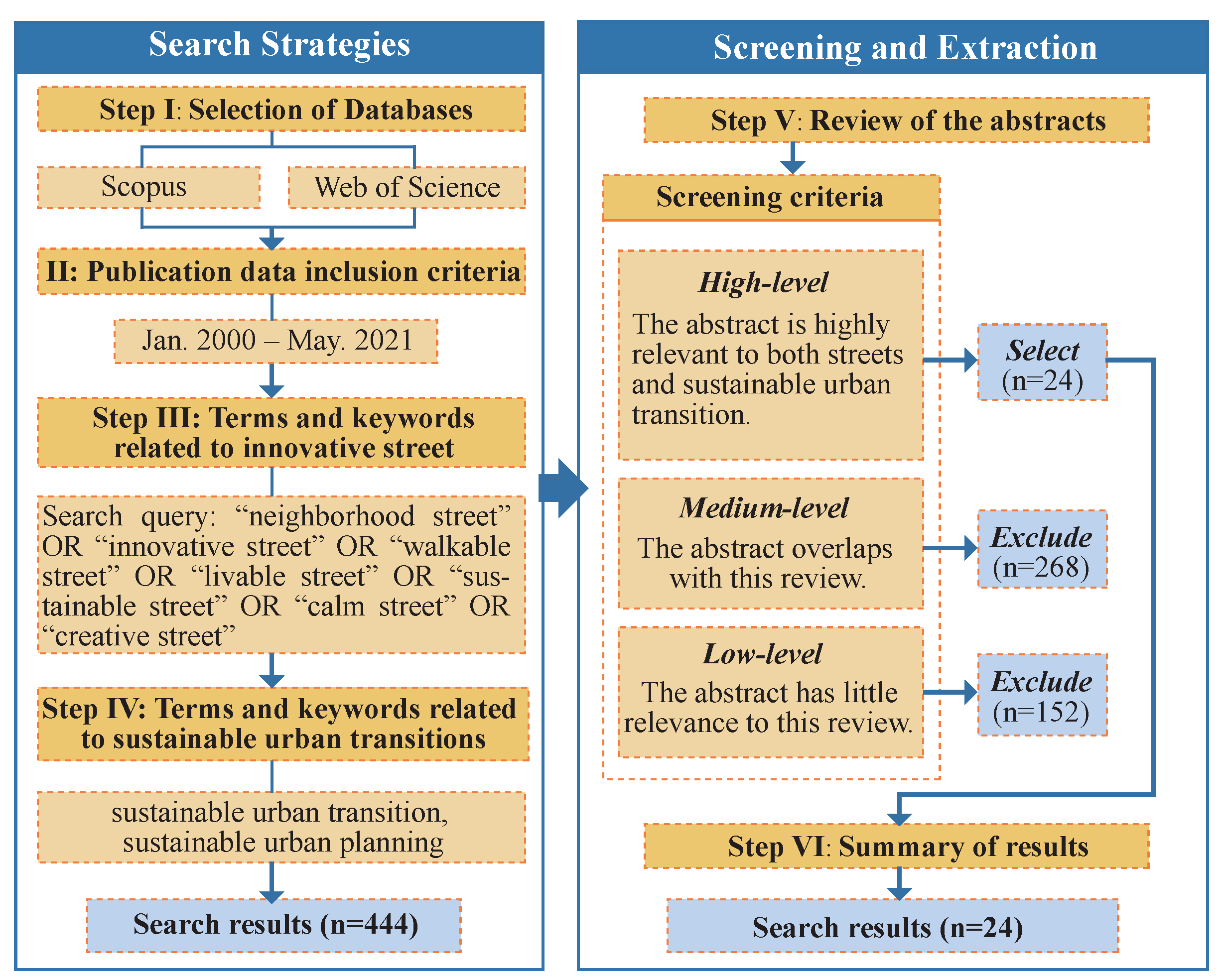
2.1. Research Scope and Search Strategy
2.2. Procedure and Data Extraction
- High level: the keywords, related terms/concepts, and conclusion of the article are highly relevant to both streets and sustainable urban transition. For instance, longitudinal research of neighborhood commercial streets in Boston has identified the relationship between physical street design, resident behavior, and urban livability [14]. Such publications contribute to the advancement of innovative streets.
- Medium level: the terms and concepts overlap with this review; however, there is sufficient content, such as case studies. Articles that examine design features for transportation or environmental purposes but do not consider street design as a means of increasing urban sustainability are considered to be of moderate relevance and are omitted.
- Low level: topics have little relevance to this review. Some papers concentrate on urban poverty and sewage management, with the street having a minimal role in the research. These articles are excluded.
3. Results
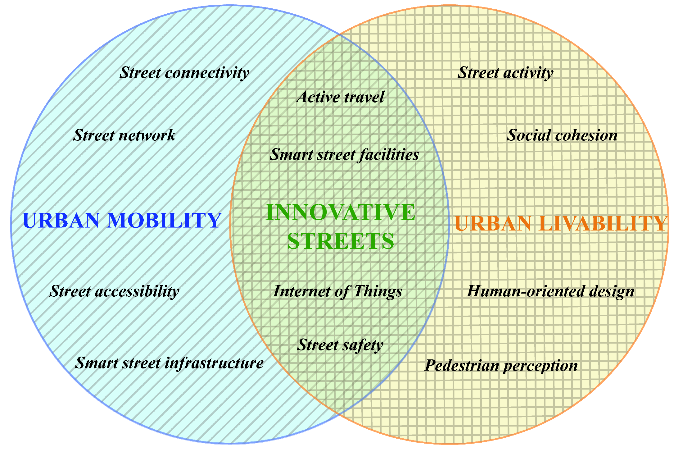
3.1. Urban Mobility
3.1.1. Smart Street Infrastructure
Street Parking
Street Charging Facilities
Smart Furniture
Smart Lighting

| I: Smart Street Infrastructure | |||
|---|---|---|---|
| Reference | Objectives | Factor(s) Examined | Results |
| [24] | To explore the technologies and projects implemented in NYC for building a smart city. |
|
|
| [17] | To grasp the full scope of on-street parking, involving demand model, land use, and environment. |
|
|
| [22] | Identify potential locations for the initial installation of residential on-street charging infrastructure for Plug-in Electric Vehicle in urban areas. |
|
|
| [18] | Introducing a street parking system to help manage on-street parking in high-density cities. |
|
|
| [19] | Using sensors organized through the wireless networks to inspire the infrastructure construction of the smart cities. |
|
|
| II: Hierarchical Street Network | |||
| Reference | Objectives | Factor(s) Examined | Results |
| [9] | To explore how urban streets can support urban resilience. |
|
|
| [25] | The aim is to examine the effects of physical environment variables on active travel and residential activities, including urban streets. |
|
|
| [26] | To clarify understanding of the different kinds of network representations and their hierarchical properties and to provide a way of capturing street network structure. |
|
|
| [12] | To assess the configuration and sustainability of street networks in China’s superblocks. |
|
|
| III: Safe Streets as a Guarantee of Access | |||
| Reference | Objectives | Factor(s) Examined | Results |
| [13] | To summarize the literature on the relationship between the built environment and traffic safety in the urban area. |
|
|
| [27] | To determine the effect of street built environment characteristics on pedestrian safety. |
|
|
| [28] | To assess the effect of street and street network characteristics on street safety. |
|
|
3.1.2. Hierarchical Street Network
3.1.3. Safe Streets as a Guarantee of Access
3.2. Urban Livability
3.2.1. Street Activities to Enhance Social Interaction
3.2.2. Human-Centered Street Environment Design
| IV: Street Activities to Enhance Social Interaction | |||
|---|---|---|---|
| Reference | Objectives | Factor(s) Examined | Results |
| [35] | To enhance the value of the urban street as a social place. |
|
|
| [37] | To understand whether streets designed to be more livable encourage more diverse street users and activities. |
|
|
| [34] | To discuss how street design and traffic affect social relations in urban neighborhoods. |
|
|
| [38] | To clarify the significance of mobility functions and public space in urban streets for sustainable urban transition. |
|
|
| V: Human-Centered Street Environment Design | |||
| Reference | Objectives | Factor(s) Examined | Results |
| [14,41] | These two studies address the relationship between social behavior and street environmental quality. |
|
|
| [40] | To analyze users’ behavior in the street space and the interaction with physical street settings. |
|
|
| [23] | To propose flexible design principles for improving the flexibility of street furniture. | Standardization, suitability, adaptation, management, and safety of street furniture |
|
| VI: Active Travel and Its Assessment Criteria | |||
| Reference | Objectives | Factor(s) Examined | Results |
| [42] | To summarize the relationship between cycling and built environment characteristics. |
|
|
| [43] | To offer visual assistance for identifying areas where modifications are required to enhance sustainable travel. |
|
|
| [44] | To outline a bicycle route choice model to advocate a better cycle-friendly street environment. |
|
|
| [15] | To evaluate walkability through GIS and street auditing indicators. |
|
|
3.2.3. Active Travel and Its Assessment Criteria
4. Discussion
4.1. Synergies and Potential Conflicts
- (1)
- Reducing the number and width of roadways for safer neighborhood intersections results in lower travel speeds, but also exacerbates traffic congestion. The compression of lane space leads to increased crossing times for drivers and waiting times for pedestrians, diminishing the efficiency of street mobility.
- (2)
- While low speeds in on-street parking can improve street safety, it can also contribute to urban congestion [40]. The presence of parking automobiles might interfere with moving vehicles and passing pedestrians by obstructing the view of each other from the driver and pedestrian [13,17,58]. Unexpected “dooring” during on-street parking threatens cyclists and pedestrians [13].
- (3)
- Physical separation improves street livability and accessibility by providing a comfortable passing experience for walkers and cyclists. Nevertheless, when high traffic volumes come, separated strips can decrease commuter efficiency as the space occupied by the separation could have been utilized for additional transportation lanes [58].
4.2. Recommendations for Designing Innovative Streets
4.2.1. Smart Street Infrastructure
4.2.2. Hierarchical Street Network
4.2.3. Safe Streets as a Guarantee of Access
4.2.4. Street Activities to Enhance Social Interaction
4.2.5. Human-Centered Street Environment Design
4.2.6. Active Travel Behavior
4.3. Principles for Further Research
4.4. Limitations
5. Conclusions and Further Directions
Author Contributions
Funding
Institutional Review Board Statement
Informed Consent Statement
Data Availability Statement
Acknowledgments
Conflicts of Interest
References
- Loorbach, D.; Wittmayer, J.M.; Shiroyama, H.; Fujino, J.; Mizuguchi, S. Governance of Urban Sustainability Transitions; Springer: Berlin/Heidelberg, Germany, 2016. [Google Scholar]
- McCormick, K.; Anderberg, S.; Coenen, L.; Neij, L. Advancing sustainable urban transformation. J. Clean. Prod. 2013, 50, 1–11. [Google Scholar] [CrossRef]
- Evans, J.; Karvonen, A.; Raven, R. The Experimental City: New Modes and Prospects of Urban Transformation. In The Experimental City; Routledge: New York, NY, USA, 2016; pp. 1–12. [Google Scholar]
- Engel, T.; Klindworth, K.; Knieling, J. Einflüsse von Pionieren auf gesellschaftliche Transformationsprozesse im Handlungsfeld Energie. In Soziale Innovationen Lokal Gestalten; Springer: Berlin/Heidelberg, Germany, 2018; pp. 215–231. [Google Scholar]
- Isaksson, K.; Heikkinen, S. Sustainability transitions at the frontline. Lock-in and potential for change in the local planning arena. Sustainability 2018, 10, 840. [Google Scholar] [CrossRef]
- Frantzeskaki, N.; Broto, V.C.; Coenen, L.; Loorbach, D. Urban Sustainability Transitions; Routledge: New York, NY, USA, 2017. [Google Scholar]
- Appleyard, D. Livable streets: Protected neighborhoods? ANNALS Am. Acad. Political Soc. Sci. 1980, 451, 106–117. [Google Scholar] [CrossRef]
- Jacobs, A.B. Great streets. ACCESS Mag. 1993, 1, 23–27. [Google Scholar]
- Sharifi, A. Resilient urban forms: A review of literature on streets and street networks. Build. Environ. 2019, 147, 171–187. [Google Scholar] [CrossRef]
- Hassen, N.; Kaufman, P. Examining the role of urban street design in enhancing community engagement: A literature review. Health Place 2016, 41, 119–132. [Google Scholar] [CrossRef]
- Yang, L.; Van Dam, K.H.; Majumdar, A.; Anvari, B.; Ochieng, W.Y.; Zhang, L. Integrated design of transport infrastructure and public spaces considering human behavior: A review of state-of-the-art methods and tools. Front. Archit. Res. 2019, 8, 429–453. [Google Scholar] [CrossRef]
- Ge, X.; Han, D. Sustainability-oriented configurational analysis of the street network of China’s superblocks: Beyond Marshall’s model. Front. Archit. Res. 2020, 9, 858–871. [Google Scholar] [CrossRef]
- Ewing, R.; Dumbaugh, E. The built environment and traffic safety: A review of empirical evidence. J. Plan. Lit. 2009, 23, 347–367. [Google Scholar] [CrossRef]
- Mehta, V.; Bosson, J. Revisiting lively streets: Social interactions in public space. J. Plan. Educ. Res. 2018, 41, 160–172. [Google Scholar] [CrossRef]
- Moura, F.; Cambra, P.; Gonçalves, A.B. Measuring walkability for distinct pedestrian groups with a participatory assessment method: A case study in Lisbon. Landsc. Urban Plan. 2017, 157, 282–296. [Google Scholar] [CrossRef]
- Cruz, S.; Paulino, S. Urban Commons in Active Mobility Experiences. Int. J. Commons 2020, 14, 539–552. [Google Scholar] [CrossRef]
- Marshall, W.E.; Garrick, N.W.; Hansen, G. Reassessing on-street parking. Transp. Res. Rec. 2008, 2046, 45–52. [Google Scholar] [CrossRef]
- Gu, J.; Zhang, Z.; Yu, F.; Liu, Q. Design and implementation of a street parking system using wireless sensor networks. In Proceedings of the IEEE 10th International Conference on Industrial Informatics, Beijing, China, 25–27 July 2012; IEEE: Piscataway, NJ, USA, 2012; pp. 1212–1217. [Google Scholar]
- Lv, Z.; Hu, B.; Lv, H. Infrastructure monitoring and operation for smart cities based on IoT system. IEEE Trans. Ind. Informatics 2019, 16, 1957–1962. [Google Scholar] [CrossRef]
- Chen, T.; Zhang, X.P.; Wang, J.; Li, J.; Wu, C.; Hu, M.; Bian, H. A review on electric vehicle charging infrastructure development in the UK. J. Mod. Power Syst. Clean Energy 2020, 8, 193–205. [Google Scholar] [CrossRef]
- He, S.Y.; Kuo, Y.H.; Wu, D. Incorporating institutional and spatial factors in the selection of the optimal locations of public electric vehicle charging facilities: A case study of Beijing, China. Transp. Res. Part C Emerg. Technol. 2016, 67, 131–148. [Google Scholar] [CrossRef]
- Grote, M.; Preston, J.; Cherrett, T.; Tuck, N. Locating residential on-street electric vehicle charging infrastructure: A practical methodology. Transp. Res. Part D Transp. Environ. 2019, 74, 15–27. [Google Scholar] [CrossRef]
- Siu, K.W.M.; Wong, K.S.L. Flexible design principles Street furniture design for transforming environments, diverse users, changing needs and dynamic interactions. Facilities 2015, 33, 588–621. [Google Scholar] [CrossRef]
- Shah, J.; Kothari, J.; Doshi, N. A survey of smart city infrastructure via case study on New York. Procedia Comput. Sci. 2019, 160, 702–705. [Google Scholar] [CrossRef]
- Saelens, B.E.; Sallis, J.F.; Frank, L.D. Environmental correlates of walking and cycling: Findings from the transportation, urban design, and planning literatures. Ann. Behav. Med. 2003, 25, 80–91. [Google Scholar] [CrossRef]
- Marshall, S. Line structure representation for road network analysis. J. Transp. Land Use 2016, 9, 29–64. [Google Scholar] [CrossRef]
- Congiu, T.; Sotgiu, G.; Castiglia, P.; Azara, A.; Piana, A.; Saderi, L.; Dettori, M. Built environment features and pedestrian accidents: An Italian retrospective study. Sustainability 2019, 11, 1064. [Google Scholar] [CrossRef]
- Marshall, W.E.; Garrick, N.W. Does street network design affect traffic safety? Accid. Anal. Prev. 2011, 43, 769–781. [Google Scholar] [CrossRef]
- Marshall, S. Streets and Patterns; Routledge: New York, NY, USA, 2004. [Google Scholar]
- Ewing, R.; Frank, L.D.; Chapman, J.; Kreutzer, R. Understanding the Relationship between Public Health and the Built Environment: A Report Prepared for the LEED-ND Core Committee. 2006. Available online: https://trid.trb.org/view/1447418 (accessed on 10 January 2022).
- Ivan, J.N.; Garrick, N.W.; Hanson, G. Designing Roads That Guide Drivers to Choose Safer Speeds. Report, 2009. Available online: https://trid.trb.org/view/908463 (accessed on 12 January 2022).
- Rifaat, S.M.; Tay, R. Effects of street patterns on injury risks in two-vehicle crashes. Transp. Res. Rec. 2009, 2102, 61–67. [Google Scholar] [CrossRef]
- Ladron de Guevara, F.; Washington, S.P.; Oh, J. Forecasting crashes at the planning level: Simultaneous negative binomial crash model applied in Tucson, Arizona. Transp. Res. Rec. 2004, 1897, 191–199. [Google Scholar] [CrossRef]
- Sauter, D.; Huettenmoser, M. Liveable streets and social inclusion. Urban Des. Int. 2008, 13, 67–79. [Google Scholar] [CrossRef]
- Brown, B.B.; Werner, C.M.; Amburgey, J.W.; Szalay, C. Walkable route perceptions and physical features: Converging evidence for en route walking experiences. Environ. Behav. 2007, 39, 34–61. [Google Scholar] [CrossRef]
- Gehl, J. Cities for People; Island Press: Washington, DC, USA, 2013. [Google Scholar]
- Biddulph, M. Radical streets? The impact of innovative street designs on liveability and activity in residential areas. Urban Des. Int. 2012, 17, 178–205. [Google Scholar] [CrossRef]
- Von Schönfeld, K.C.; Bertolini, L. Urban streets: Epitomes of planning challenges and opportunities at the interface of public space and mobility. Cities 2017, 68, 48–55. [Google Scholar] [CrossRef]
- Lynch, K. City Sense and City Design: Writings and Projects of Kevin Lynch; MIT Press: Cambridge, MA, USA, 1995. [Google Scholar]
- Do, D.T.; Mori, S.; Nomura, R. An Analysis of Relationship between the Environment and User’s Behavior on Unimproved Streets: A Case Study of Da Nang City, Vietnam. Sustainability 2019, 11, 83. [Google Scholar] [CrossRef]
- Mehta, V. Lively streets: Determining environmental characteristics to support social behavior. J. Plan. Educ. Res. 2007, 27, 165–187. [Google Scholar] [CrossRef]
- Yang, Y.; Wu, X.; Zhou, P.; Gou, Z.; Lu, Y. Towards a cycling-friendly city: An updated review of the associations between built environment and cycling behaviors (2007–2017). J. Transp. Health 2019, 14, 100613. [Google Scholar] [CrossRef]
- Winters, M.; Brauer, M.; Setton, E.M.; Teschke, K. Mapping bikeability: A spatial tool to support sustainable travel. Environ. Plan. B-Plan. Des. 2013, 40, 865–883. [Google Scholar] [CrossRef]
- Broach, J.; Dill, J.; Gliebe, J. Where do cyclists ride? A route choice model developed with revealed preference GPS data. Transp. Res. Part A Policy Pract. 2012, 46, 1730–1740. [Google Scholar] [CrossRef]
- Ewing, R.H.; Clemente, O.; Neckerman, K.M.; Purciel-Hill, M.; Quinn, J.W.; Rundle, A. Measuring Urban Design: Metrics for Livable Places; Springer: Berlin/Heidelberg, Germany, 2013; Volume 200. [Google Scholar] [CrossRef]
- Allan, P.; Bryant, M.; Wirsching, C.; Garcia, D.; Teresa Rodriguez, M. The influence of urban morphology on the resilience of cities following an earthquake. J. Urban Des. 2013, 18, 242–262. [Google Scholar] [CrossRef]
- Villagra, P.; Rojas, C.; Ohno, R.; Xue, M.; Gómez, K. A GIS-base exploration of the relationships between open space systems and urban form for the adaptive capacity of cities after an earthquake: The cases of two Chilean cities. Appl. Geogr. 2014, 48, 64–78. [Google Scholar] [CrossRef]
- Davis, J.; Uffer, S. Evolving Cities: Exploring the Relations between Urban form ‘Resilience’ and the Governance of Urban Form. 2013. Available online: https://orca.cardiff.ac.uk/id/eprint/89205/ (accessed on 13 January 2022).
- Apparicio, P.; Landry, S.; Lewnard, J. Disentangling the effects of urban form and socio-demographic context on street tree cover: A multi-level analysis from Montréal. Landsc. Urban Plan. 2017, 157, 422–433. [Google Scholar] [CrossRef]
- Whyte, W.H. The Social Life of Small Urban Spaces. 1980. Available online: https://trid.trb.org/view/521122 (accessed on 10 January 2022).
- Villani, C.; Talamini, G. Pedestrianised streets in the global neoliberal city: A battleground between hegemonic strategies of commodification and informal tactics of commoning. Cities 2021, 108, 102983. [Google Scholar] [CrossRef]
- Duany, A.; Plater-Zyberk, E.; Speck, J. Suburban Nation: The Rise of Sprawl and the Decline of the American Dream; Macmillan: London, UK, 2001. [Google Scholar]
- Sun, Q.; Macleod, T.; Both, A.; Hurley, J.; Butt, A.; Amati, M. A human-centred assessment framework to prioritise heat mitigation efforts for active travel at city scale. Sci. Total Environ. 2021, 763, 143033. [Google Scholar] [CrossRef]
- Cervero, R.; Kockelman, K. Travel demand and the 3Ds: Density, diversity, and design. Transp. Res. Part D Transp. Environ. 1997, 2, 199–219. [Google Scholar] [CrossRef]
- Ewing, R.; Cervero, R. Travel and the built environment: A meta-analysis. J. Am. Plan. Assoc. 2010, 76, 265–294. [Google Scholar] [CrossRef]
- Ewing, R.; Handy, S. Measuring the unmeasurable: Urban design qualities related to walkability. J. Urban Des. 2009, 14, 65–84. [Google Scholar] [CrossRef]
- Gardner, K.; Johnson, T.; Buchan, K.; Pharaoh, T. Developing a pedestrian strategy for London. In Proceedings of the Transport Policy and Its Implementation. Proceedings of Seminar B held at the 24th European Transport Forum, Brunel University, London, UK, 2–6 September 1996; Volume P402. [Google Scholar]
- Li, Z.; Wang, W.; Liu, P.; Ragland, D.R. Physical environments influencing bicyclists’ perception of comfort on separated and on-street bicycle facilities. Transp. Res. Part D Transp. Environ. 2012, 17, 256–261. [Google Scholar] [CrossRef]


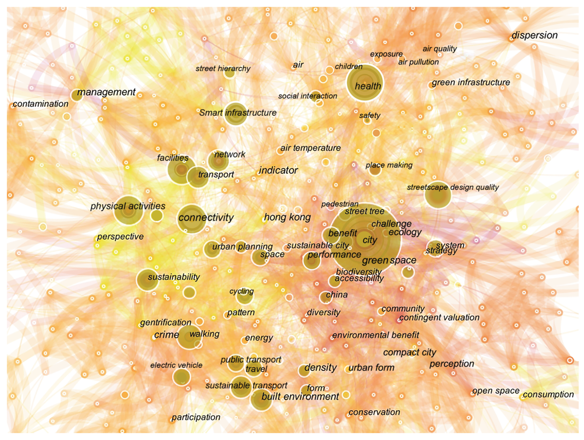
| Research Topic | Keyword Co-Occurrence Analysis | Sub-Themes |
|---|---|---|
| Smart infrastructure, facilities, management | Smart street infrastructure | |
| Urban mobility | Connectivity, accessibility, density, street hierarchy, street network | Hierarchical street network |
| Safety, children, accessibility | Safe streets as a guarantee of access | |
| Physical activities, social interaction, health, place making | Street activities to enhance social interaction | |
| Urban livability | Streetscape design quality, pedestrian, physical environment | Human-centered Street environment design |
| Walking, cycling, sustainable transport, public transport, travel, electric vehicle | Active travel and its assessment criteria |
| Elements | Theoretical Findings |
|---|---|
| Street width | |
| Sidewalk |
|
| Seats | |
| Railings |
|
| Curbs | |
| Street signage | |
| Street green |
Disclaimer/Publisher’s Note: The statements, opinions and data contained in all publications are solely those of the individual author(s) and contributor(s) and not of MDPI and/or the editor(s). MDPI and/or the editor(s) disclaim responsibility for any injury to people or property resulting from any ideas, methods, instructions or products referred to in the content. |
© 2023 by the authors. Licensee MDPI, Basel, Switzerland. This article is an open access article distributed under the terms and conditions of the Creative Commons Attribution (CC BY) license (https://creativecommons.org/licenses/by/4.0/).
Share and Cite
Rui, J.; Othengrafen, F. Examining the Role of Innovative Streets in Enhancing Urban Mobility and Livability for Sustainable Urban Transition: A Review. Sustainability 2023, 15, 5709. https://doi.org/10.3390/su15075709
Rui J, Othengrafen F. Examining the Role of Innovative Streets in Enhancing Urban Mobility and Livability for Sustainable Urban Transition: A Review. Sustainability. 2023; 15(7):5709. https://doi.org/10.3390/su15075709
Chicago/Turabian StyleRui, Jin, and Frank Othengrafen. 2023. "Examining the Role of Innovative Streets in Enhancing Urban Mobility and Livability for Sustainable Urban Transition: A Review" Sustainability 15, no. 7: 5709. https://doi.org/10.3390/su15075709