Communication

Annual Mangrove Vegetation Cover Changes (2014–2020) in Indian Sundarbans National Park Using Landsat 8 and Google Earth Engine

by
Gwendolyn Karsch
1,
Sharif A. Mukul
2,3,* and
Sanjeev Kumar Srivastava
2,*
1
Institute of Geography, University of Bonn, 53115 Bonn, Germany
2
School of Science, Technology and Engineering (SSTE), University of the Sunshine Coast, Maroochydore DC, QLD 4556, Australia
3
Department of Environment and Development Studies, United International University, Dhaka 1212, Bangladesh
*
Authors to whom correspondence should be addressed.
Sustainability 2023, 15(6), 5592; https://doi.org/10.3390/su15065592
Submission received: 28 January 2023 / Revised: 3 March 2023 / Accepted: 21 March 2023 / Published: 22 March 2023
(This article belongs to the Special Issue Frontiers in Wetland Ecology and Environmental Sustainability)

Abstract

:
Mangrove ecosystems have high ecological and economic value mainly because of their ability to sequester large amounts of carbon and protect shorelines. Monitoring such ecosystems with earth observation data analytics is necessary to achieve deeper insight and subsequent conservation strategies. The Sundarbans is the world’s largest contiguous mangrove forest, and Sundarbans National Park is a part of this world-famous mangrove forest in India. To examine vegetation change in this region, we used a planetary-scale tool, the Google Earth Engine. A time series of the surface reflectance product of Landsat 8 between 2014 and 2020 was analysed using annual median images. NDVI and dNDVI were derived to monitor vegetation cover change. While we noticed no major changes in the vegetation cover throughout the study area, the coastal regions, especially the southern end, showed significant changes. There were both mangrove vegetation gains due to land accretion and mangrove loss due to erosion and cyclone damage. This study will be useful for long-term monitoring of the imperiled Sundarbans ecosystem to measure any major changes.

1. Introduction

Mangrove forests are found in the tropical and subtropical intertidal coastal zone (roughly between 30° north and 30° south) and consist of salt-tolerant tree and shrub species [1,2,3]. Globally, they cover a relatively small area (about 0.1% of the total area) and occupy a small ecological niche, but in contrast have immense ecological and economic significance [4,5,6]. One of the key properties of mangroves is their ability to sequester large amounts of carbon in their biomass within a relatively short period which is becoming increasingly important under changing climatic scenarios and a warmer world [7,8]. Additionally, mangroves stabilise coastlines by protecting from natural hazards, especially cyclones [1,3,9]. Similar to many other tropical ecosystems, mangrove forests are under intense pressure from natural and anthropogenic factors [1,10,11,12]. Large areas of mangrove forests have already been lost worldwide, and the trend is continuing, if not accelerating [1,5].
The Sundarbans is the world’s largest contiguous mangrove forest shared between Bangladesh and India, covering an area of about 10,000 square kilometers [13,14]. Apart from many ecosystem services, the Sundarbans is critical for the livelihoods of about 7.2 million people in Bangladesh and India [4,15]. Past studies indicate that the mangrove ecosystem in the Sundarbans forest is dynamic, and patterns of change are complex [2,4,15,16]. Tropical cyclones are among the major natural factors influencing the structure and functioning of the Sundarbans mangrove forest [17]. Apart from cyclones, sea level rise, increases in salinity, vegetation loss, and erosion are also common in the Sundarbans [13,18]. Projected climatic change scenarios not only magnify the deleterious effects of cyclones but also affect the coastal area with sea-level rise and changes in precipitation patterns in the Sundarbans region [13,19]. The processes of accretion and erosion also influence the characteristics and extent of mangrove forests and, thus, their ability to provide key ecosystem services [4]. In addition to natural factors, humans also have a major impact on mangrove ecosystems through unplanned coastal infrastructure and other development [14]. Areas are lost, for example, due to overexploitation of timber and non-timber forest products (NTFPs), expansion and intensification of agriculture, aquaculture, deforestation, and pollution [4,20].
Due to the ecological and economic importance of Sundarbans mangrove forests, there is a necessity for continuous short- and long-term monitoring of the ecosystem [3,4]. Given the extent, remoteness, and inaccessibility of most parts of the Sundarbans forest, conducting field data over the entire ecosystem for monitoring is challenging [21]. Therefore, the use of earth observation (EO) data analytics is useful because such a method provides continuous future information as well as archived past information [4,22]. With EO data mangrove extent together with biophysical, parameters such as biomass can be estimated. Such information could then be linked to ecosystem processes such as carbon fluxes, which is a key piece of information for climate change mitigation potential. With EO data archives, it is much easier to perform change and time series analysis [22]. The EO offers a variety of data collected with optical, microwave (SAR), and LiDAR sensors that are utilised individually as well as in combination to address specific issues [3,4]. The optical EO data offers a huge archive of information available from the 1970s (e.g., Landsat series). The availability of this huge repository on cloud-based tools such as Google Earth Engine enables faster data analytics on the available data archive. Access to data archives enables the application of cloud masks and thereafter creates mean/median data (e.g., mean/median Normalised Difference Vegetation Index, NDVI) for a given period. In the present study, Sundarbans National Park within the Sundarbans mangrove forest in the Indian part was investigated using Landsat 8 data to study changes in vegetation between 2014 and 2020. Our study is an initial attempt to combine Landsat 8 and Google Earth Engine for the Sundarbans region and has wider implications for management, conservation, and informed decision-making for the Sundarbans forest and other forests in similar contexts.

2. Materials and Methods

2.1. The Study Area

The study was conducted in the Sundarbans National Park of the Indian Sundarbans region (Figure 1). Shared between Bangladesh and India, the Sundarbans is the world’s largest contiguous mangrove forest and has been enlisted as a UNESCO World Heritage Site [14]. The Sundarbans has an incredibly high ecological and economic value at global and regional scales [4,15]. This mangrove forest encompasses the region of the Ganges Delta formed by the three major rivers, the Ganges, Brahmaputra, and Meghna, and consists of a large system of smaller rivers and islands [2,4].
The climate of the Sundarbans is tropical and is significantly affected by the monsoon season and the occurrence of cyclones [2,4]. Therefore, the following seasons can be roughly defined: winter, which is mostly dry (from December to February); pre-monsoon/summer (from March to May); monsoon (from June to September); and post-monsoon (October to November) [4]. The elevation of most of the Sundarbans is very low, with a maximum of 2 m above mean sea level [13].
The entire Sundarbans is characterised by very high biodiversity, providing habitats for many different species of animals and plants [2,15]. Among others, species like the Bengal Tiger and Saltwater Crocodile can be found in the region [15]. In terms of flora, predominant mangrove species include Heritiera fomes, Excoecaria agallocha, and Ceriops decandra [2]. The Sundarbans mangrove forest is surrounded by populous communities that rely on its ecological resources [4,15].

2.2. Data Sets and Sources

For this study, we used surface reflectance data derived from Landsat 8 OLI sensor available on Google Earth Engine (GEE) that is available from 2013 onwards (LANDSAT/LC08/C02/T1_L2). The Google Earth Engine is a planetary-scale cloud-based platform where many earth observation data and data products can be accessed [23,24]. Surface reflectance refers to the image data where reflectance values are calibrated for the reflectance at the ground surface after atmospherically correcting raw image data. Such calibration enables the removal of aerosol effects and renders data sets much more suitable for temporal analysis (e.g., change in vegetation cover) [24,25]. All Landsat 8 OLI spectral bands are available on GEE, and for this study, we calculated the Normalised Difference Vegetation Index (NDVI) using Band 4 (red, 0.64–0.67 µm) and Band 5 (near-infrared, 0.85–0.88 µm) [24,26,27]. We used all data sets available between 2014 and 2020 and utilised the QA band of the product to mask clouds and cloud shadows [24].

2.3. Image Analysis and Interpretation
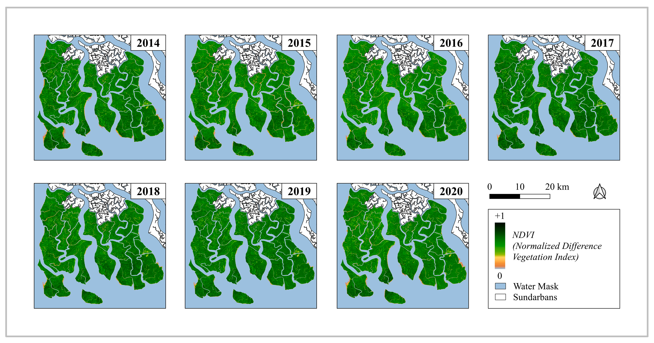
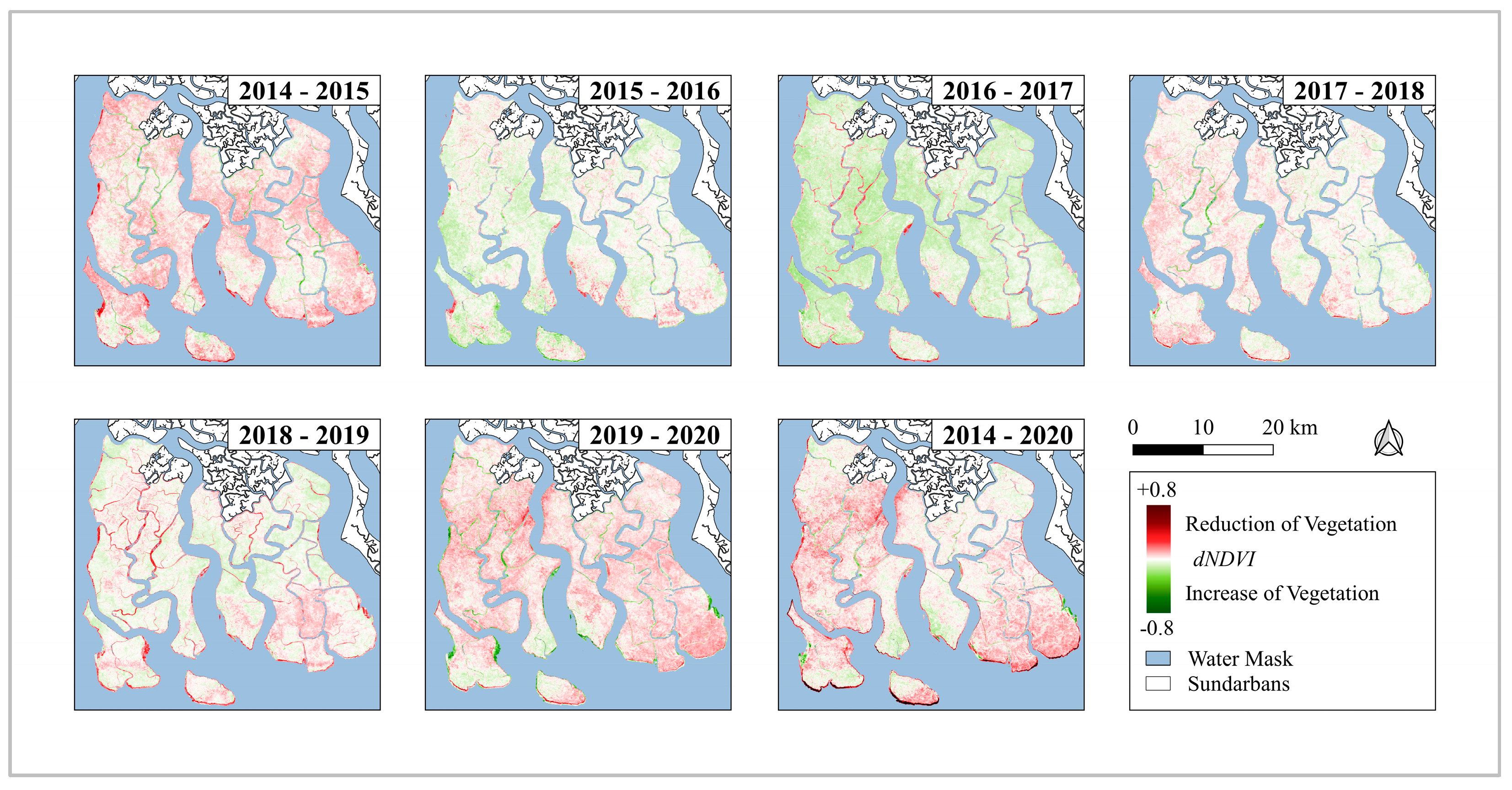
To analyse the change in vegetation condition of the study area between January 2014 and December 2020, a median image for each year was computed from all cloud and cloud shadow masked Landsat 8 surface reflectance data using the median() function available in Google Earth Engine. Thereafter, a vegetation index in that year was calculated by deriving NDVI using Equation (1) [9,28].
NDVI = N I R R E D N I R + R E D
The resulting value is between −1 and 1 and provides information about the land cover and its condition for each pixel. The higher the value, the healthier and denser the vegetation. Negative values indicate water [28,29]. The resulting images, therefore, represent the median vegetation condition of each year of the study period (2014–2020) and thus provide information about the type of land cover for each pixel of the study area. Finally, to determine the difference in vegetation condition, the delta-NDVI (dNDVI) was calculated for the time periods 2014–2015, 2015–2016, 2016–2017, 2017–2018, 2018–2019, 2019–2020, and finally 2014–2020 using the following formula:
dNDVI = N D V I p r e v i o u s N D V I p o s t
Using the results of the NDVI calculations, a land mask was then created in ArcGIS Pro to exclude water bodies by assigning them no data value [29]. This was done by estimating the maximum extent of vegetation together with land mass by reclassifying NDVI values. Polygons were then created from the resulting raster files using the appropriate function, considering only those values that represented vegetated areas. All resulting layers were then merged to obtain a final polygon encompassing the maximum extent of the vegetated area. This resulting layer was then used to crop out the areas of constant water from the NDVI images without losing areas that had varying NDVI values. In this way, only the changes in the vegetated areas were further analysed, and all effects of permanent water were removed. Finally, to estimate vegetation change, a visual interpretation of the mean NDVI and delta-NDVI maps was performed. In addition, the data were evaluated using descriptive statistics such as mean, maximum and minimum, and standard deviation.

3. Results

The results of the analysis performed in this study are presented below. Figure 2 shows the images for the mean NDVI for each year. Figure 3 shows the statistical results with minimum, maximum, mean, and standard deviation for each year of the study period.
The entire area generally has high NDVI values, indicating healthy and dense vegetation. Only in smaller areas are lower NDVI values observed. The spatial extent of these areas, however, varied slightly on the temporal scale. Relatively lower NDVI values were noticed in the eastern part of the study area. The summary of the statistical analysis is presented in Figure 3, which provides important insight and the trends for the entire period.
As can be seen in the upper left graph in Figure 3, the minimum NDVI values, which averaged about −0.5, decreased on average over the study period. The year 2019 recorded the lowest minimum NDVI value. The upper right graph shows the maximum NDVI values for each year during the study period. The average value was about 0.85. The calculated trend for the entire period shows that the maximum value decreased slightly on average, but the last value for 2020 was the second highest. Therefore, it is not possible to assume a clear trend. For the mean NDVI (see lower left graph), which averaged about 0.565, the calculated trend also indicates a very slight decreasing trend. With the exception of 2016, 2020 recorded the lowest mean NDVI value. Finally, the standard deviation (see the lower right graph in Figure 3), which averaged about 0.19, recorded an increase. The spatial changes were examined using the delta NDVI calculations presented in Figure 4, where the changes in the mean NDVI are visualised from year to year and for the entire study period.
In the periods between 2014 and 2015, 2017 and 2018, and 2019 and 2020, positive values, i.e., a decrease in vegetation, were recorded over large areas; only smaller regions, especially centrally located areas of the islands, registered no changes or negative values, representing an increase in vegetation. A decrease in vegetation was observed in the areas exposed to the coast, especially in the southern part of the study area. Increases in vegetation were recorded in larger areas during the periods between 2015 and 2016, 2016 and 2017, and 2018 and 2019. However, declines were also noted in many coastal areas. Finally, the last image, showing changes between 2014 and 2020, illustrates the long-term changes that occurred during the study period. Here, it is evident that southern islands in particular experienced declines in southern coastal vegetation. Overall, a decline in vegetation was observed in some (mainly southern) coastal sections. Other areas, for example on the east coast, recorded an increase. A large portion of the study area, especially in the northeast and central areas, also showed little change in their mean NDVI.

4. Discussion

Our results suggest that there were no significant changes in the mean NDVI in large parts of the Sundarbans National Park for the entire period. While the coastal sections in the southern part of the southernmost islands recorded significant changes in vegetation cover, mainly on the negative side, in some other regions, vegetation cover increased in coastal areas. Thus, the coastal areas as a whole, and especially in the southern part of the study area, show more dynamic changes, while in other areas, especially in those in the center of the island, there were no significant changes in vegetation cover.
In a study that focused on mapping long-term changes at the species level in the Sundarbans mangrove forest between 1977 and 2015, Ghosh et al. [4] found that dynamic changes occurred along the Sundarbans coastline, particularly in the regions where the most significant changes were also found in this study. This may primarily be attributed to coastal erosion and accretion [16]. This coastal retreat could increase the vulnerability of the Sundarbans mangrove forest where our study area is located [4]. In other studies, e.g., by Awty-Carroll et al. [2], cyclone events could be attributed to changes in land cover in the Sundarbans [30,31]. They also noted that changes in species composition occurred, which may also affect the results of NDVI analyses [2,31].
Google Earth Engine was very well suited for the purpose of this study and allowed for fast and efficient processing of the large dataset. The script and link to the respective code can be found in the Supplementary Material (see Supplementary Material S1). The method employed in this study, i.e., the use of the Normalised Difference Vegetation Index, was appropriate for illustrating general changes in vegetation cover. However, it cannot be used to identify changes at the species level or to analyse the causes of such changes. It only highlights areas where there has been a general increase or decrease in vegetation cover. It can be also used to identify potentially vulnerable areas where more dynamic changes have occurred. However, for further insight, it is necessary to relate various parameters to the results to identify possible reasons for these changes. In addition, NDVI analyses could be conducted before and after extreme weather events, such as cyclones, to determine the impact of such catastrophic events although cloud cover could be an issue. To illustrate small-scale changes, a detailed analysis of changes on an island-by-island basis may also be performed.

5. Conclusions

In light of climate change and anthropogenic disturbances, monitoring changes in highly ecologically valuable mangrove forests is extremely important. Not only do they provide livelihoods for many people but they also play an incomparably important role globally due to their ability to sequester large amounts of atmospheric carbon. As the largest contiguous mangrove forest in the world, this is particularly applicable to the Sundarbans mangrove forest and thus the Sundarbans National Park.
Our analyses using satellite imaging (i.e., Landsat 8) and Google Earth Engine revealed that while vegetation cover changed insignificantly from year to year and throughout the study period in most parts of the Sundarbans National Park, many coastal areas showed significant and large decreases (and some also showed increases) in vegetation cover. These areas can be classified as regions whose characteristics make them particularly susceptible to more dynamic changes than others. It is possible that processes such as erosion and accretion are responsible for these changes, but further research is needed to verify this. Because of its global importance, establishing a monitoring system to continuously monitor vegetation changes in the Sundarbans mangrove forests for early detection of potential threats is also crucial.

Supplementary Materials

The following supporting information can be downloaded at: https://www.mdpi.com/article/10.3390/su15065592/s1, Supplementary Material S1 (Google Earth Engine Script used in the study).

Author Contributions

Conceptualization, G.K., S.K.S., and S.A.M.; methodology, G.K. and S.K.S.; formal analysis, G.K. and S.K.S.; investigation, G.K.; data curation, G.K.; writing—original draft preparation, G.K.; writing—review and editing, S.K.S. and S.A.M.; supervision, S.K.S.; project administration, S.K.S.; funding acquisition, S.K.S. All authors have read and agreed to the published version of the manuscript.

Funding

This research was partly funded by “Asia-Pacific Network for Global Change Research (CRRP2020-08MY; https://doi.org/10.30852/p.13609)” and by the University of the Sunshine Coast to Sanjeev Srivastava. Gwendolyn Karsch’s visit to Australia was funded by the DAAD-RISE program.

Institutional Review Board Statement

Not applicable.

Informed Consent Statement

Not applicable.

Data Availability Statement

Relevant data will be made available upon request.

Acknowledgments

Gwendolyn Karsch was supported by Deutscher Akademischer Austauschdienst (DAAD, Germany) to visit the University of the Sunshine Coast (Australia). Sharif A. Mukul was supported by the British Ecological Society (UK), and National Geographic Society (USA). Finally, we are grateful to University of the Sunshine Coast (Australia) for providing office space to Gwendolyn Karsch and other necessary supports to Sanjeev Srivastava. The authors acknowledge the valuable comments and suggestions provided by 4 anonymous reviewers and the editor which substantially improved the quality of the manuscript.

Conflicts of Interest

The authors declare no conflict of interest.

References

  1. Giri, C. Observation and Monitoring of Mangrove Forests Using Remote Sensing: Opportunities and Challenges. Remote Sens. 2016, 8, 783. [Google Scholar] [CrossRef] [Green Version]
  2. Awty-Carroll, K.; Bunting, P.; Hardy, A.; Bell, G. Using Continuous Change Detection and Classification of Landsat Data to Investigate Long-Term Mangrove Dynamics in the Sundarbans Region. Remote Sens. 2019, 11, 2833. [Google Scholar] [CrossRef] [Green Version]
  3. Pham, T.D.; Yokoya, N.; Bui, D.T.; Yoshino, K.; Friess, D.A. Remote Sensing Approaches for Monitoring Mangrove Species, Structure, and Biomass: Opportunities and Challenges. Remote Sens. 2019, 11, 230. [Google Scholar] [CrossRef] [Green Version]
  4. Ghosh, M.K.; Kumar, L.; Roy, C. Mapping Long-Term Changes in Mangrove Species Composition and Distribution in the Sundarbans. Forests 2016, 7, 305. [Google Scholar] [CrossRef] [Green Version]
  5. Thomas, N.; Lucas, R.; Bunting, P.; Hardy, A.; Rosenqvist, A.; Simard, M. Distribution and drivers of global mangrove forest change, 1996–2010. PLoS ONE 2017, 12, e0179302. [Google Scholar] [CrossRef] [PubMed] [Green Version]
  6. Ho, Y.S.; Mukul, S.A. Publication performance and trends in mangrove forest: A bibliometric analysis. Sustainability 2021, 13, 12532. [Google Scholar] [CrossRef]
  7. Donato, D.C.; Kauffman, J.B.; Murdiyarso, D.; Kurnianto, S.; Stidham, M.; Kanninen, M. Mangroves among the most carbon-rich forests in the tropics. Nat. Geosci. 2011, 4, 293–297. [Google Scholar] [CrossRef]
  8. Alongi, D.M. Carbon sequestration in mangrove forests. Carbon Manag. 2012, 3, 313–322. [Google Scholar] [CrossRef]
  9. Chamberlain, D.A.; Phinn, S.R.; Possingham, H.P. Mangrove Forest Cover and Phenology with Landsat Dense Time Series in Central Queensland, Australia. Remote Sens. 2021, 13, 3032. [Google Scholar] [CrossRef]
  10. Goldberg, L.; Lagomasino, D.; Thomas, N.; Fatoyinbo, T. Global declines in human-driven mangrove loss. Global Change Biol. 2020, 26, 5844–5855. [Google Scholar] [CrossRef]
  11. Biswas, P.L.; Biswas, S.R. Mangrove Forests: Ecology, Management, and Threats. In Life on Land, Encyclopedia of the UN Sustainable Development Goals; Leal Filho, W., Azul, A., Brandli, L., Lange Salvia, A., Wall, T., Eds.; Springer: Cham, Switzerland, 2019; pp. 635–648. [Google Scholar] [CrossRef]
  12. Spalding, M.D.; Leal, M. (Eds.) The State of the World’s Mangroves; Global Mangrove Alliance: Arlington County, VA, USA, 2021. [Google Scholar]
  13. Mukul, S.A.; Alamgir, M.; Sohel, M.S.I.; Pert, P.L.; Turton, S.M.; Herbohn, J.; Khan, M.S.I.; Ali Reza, A.H.M.; Munim, S.A.; Laurance, W.F. Combined effects of climate change and sea-level rise project dramatic habitat loss of the globally endangered Bengal tiger in the Bangladesh Sundarbans. Sci. Total Environ. 2019, 663, 830–840. [Google Scholar] [CrossRef] [PubMed]
  14. Mukul, S.A.; Huq, S.; Herbohn, J.; Seddon, N.; Laurance, W.F. Saving the Sundarbans from development. Science 2020, 368, 1198. [Google Scholar] [CrossRef]
  15. Danda, A.A.; Sriskanthan, G.; Ghosh, A.; Bandyopadhyay, J.; Hazra, S. Indian Sundarbans Delta: A Vision; World Wide Fund (WWF) for Nature-India: New Delhi, India, 2011. [Google Scholar]
  16. Bhargava, R.; Friess, D.A. Previous shoreline dynamics determine future susceptibility to cyclone damage in the Sundarbans mangrove forest. Front. Mar. Sci. 2022, 9, 814577. [Google Scholar] [CrossRef]
  17. Halder, N.K.; Merchant, A.; Misbahuzzaman, K.; Wagner, S.; Mukul, S.A. Why some trees are more vulnerable during catastrophic cyclone events in the Sundarbans mangrove forest of Bangladesh? For. Ecol. Manag. 2021, 490, 119117. [Google Scholar] [CrossRef]
  18. Azad, M.S.; Kamruzzaman, M.; Osawa, A. The influences of cyclone on abundance, species diversity and floristic composition in mangrove ecosystem in the Sundarbans, Bangladesh. Regional Stud. Mar. Sci. 2019, 28, 100621. [Google Scholar] [CrossRef]
  19. Ward, R.D.; Friess, D.A.; Day, R.H.; MacKenzie, R.A. Impacts of climate change on mangrove ecosystems: A region by region overview. Ecosyst. Health Sust. 2016, 2, e01211. [Google Scholar] [CrossRef] [Green Version]
  20. Friess, D.A.; Rogers, K.; Lovelock, C.E.; Krauss, K.W.; Hamilton, S.E.; Lee, S.Y.; Lucas, R.; Primavera, J.; Rajkaran, A.; Shi, S. The state of the world’s mangrove forests: Past, present, and future. Annu. Rev. Environ. Resour. 2019, 44, 89–115. [Google Scholar] [CrossRef] [Green Version]
  21. Zhang, Z.; Ahmed, M.R.; Zhang, Q.; Li, Y.; Li, Y. Monitoring of 35-Year Mangrove Wetland Change Dynamics and Agents in the Sundarbans Using Temporal Consistency Checking. Remote Sens 2023, 15, 625. [Google Scholar] [CrossRef]
  22. Wang, L.; Jia, M.; Yin, D.; Tian, J. A review of remote sensing for mangrove forests: 1956–2018. Remote Sens. Environ. 2019, 231, 111223. [Google Scholar] [CrossRef]
  23. Gorelick, N.; Hancher, M.; Dixon, M.; Ilyushchenko, S.; Thau, D.; MOORE, R. Google Earth Engine: Planetary-scale geospatial analysis for everyone. Remote Sens. Environ. 2017, 202, 18–27. [Google Scholar] [CrossRef]
  24. Google Earth Engine. Earth Engine Catalog. USGS Landsat 8 Level 2, Collection 1, Tier 1. 2021. Available online: https://developers.google.com/earth-engine/datasets/catalog/LANDSAT_LC08_C02_T1_L2#description (accessed on 29 September 2021).
  25. United States Geological Survey. Landsat Collection 1 Surface Reflectance. 2021. Available online: https://www.usgs.gov/core-science-systems/nli/landsat/landsat-collection-1-surface-reflectance (accessed on 22 September 2021).
  26. United States Geological Survey. Landsat Missions. Landsat 8. 2021. Available online: https://www.usgs.gov/core-science-systems/nli/landsat/landsat-8?qt-science_support_page_related_con=0#qt-science_support_page_related_con (accessed on 30 September 2021).
  27. United States Geological Survey. Landsat Normalized Difference Vegetation Index. 2021. Available online: https://www.usgs.gov/core-science-systems/nli/landsat/landsat-normalized-difference-vegetation-index?qt-science_support_page_related_con=0#qt-science_support_page_related_con (accessed on 20 September 2021).
  28. United States Geological Survey. NDVI, the Foundation for Remote Sensing Phenology. 2021. Available online: https://www.usgs.gov/core-science-systems/eros/phenology/science/ndvi-foundation-remote-sensing-phenology?qt-science_center_objects=0#qt-science_center_objects (accessed on 23 September 2021).
  29. Macarof, P.; Statescu, F. Comparison of NDBI and NDVI as Indicators of Surface Urban Heat Island Effect in Landsat 8 Imagery: A Case Study of Iasi. Present Environ. Sust. Dev. 2017, 11, 141–150. [Google Scholar] [CrossRef] [Green Version]
  30. Dutta, D.; Das, P.K.; Paul, S.; Sharma, J.R.; Dadhwal, V.K. Assessment of ecological disturbance in the mangrove forest of Sundarbans caused by cyclones using MODIS time-series data (2001–2011). Nat. Hazards 2015, 79, 775–790. [Google Scholar] [CrossRef]
  31. Small, C.; Sousa, D. Spatiotemporal Characterization of Mangrove Phenology and Disturbance Response: The Bangladesh Sundarban. Remote Sens. 2019, 11, 2063. [Google Scholar] [CrossRef] [Green Version]
Figure 1. Geographical location of the Sundarbans across India and Bangladesh and the study area (dark color). This study uses part of the Indian Sundarbans that is subjected to cyclonic activities.
Sustainability 15 05592 g001
Figure 2. Mean NDVI maps of the study area for each year of the study period.
Sustainability 15 05592 g002
Figure 3. Results of statistical analysis (parameter: minimum, maximum, mean, and standard deviation) of the NDVI calculation for each year of the study period in the whole study area.
Sustainability 15 05592 g003
Figure 4. NDVI maps of the study area for each year of the study period (visually enhanced to show changes more clearly).
Sustainability 15 05592 g004
Disclaimer/Publisher’s Note: The statements, opinions and data contained in all publications are solely those of the individual author(s) and contributor(s) and not of MDPI and/or the editor(s). MDPI and/or the editor(s) disclaim responsibility for any injury to people or property resulting from any ideas, methods, instructions or products referred to in the content.

