
Shaping Public Space in Informal Settlements: A Case Study

School of Geography and Planning, Cardiff University, Cardiff CF10 3WA, UK
Sustainability 2023, 15(4), 3781; https://doi.org/10.3390/su15043781
Submission received: 12 January 2023
/
Revised: 9 February 2023
/
Accepted: 13 February 2023
/
Published: 18 February 2023
(This article belongs to the Section Sustainable Urban and Rural Development)
Abstract
:Informal settlement has become one of the critical ways of producing space and accessing affordable housing, particularly in the context of the global South. Much of the established literature on the shaping of public space focuses on cities of the global North, and little is known about how public spaces are being shaped in more congested and less formal cities of the global South. This paper engages with the challenge of understanding the shaping of public space in informal settlements with a focus on exploring the spatial structures and increments of change in a case study in Medellin (Colombia). This is primarily an urban design exploration, which deploys direct observation, extensive urban photography, and field notes as key research methods. This paper contributes a critical case study, which has experienced forms of informal and formal transformations. The spatial structures and increments of change are explored in the selected case study and further discussed in the context of the relevant literature. This paper argues that much of the shaping of public space in informal settlements can be considered as “unfinished” in the sense that their “incompleteness” enables a degree of flexibility for possible adaptations in relation to individual/collective needs and desires. The article also reflects on how producing mixed morphologies can be considered as an attempt that may possibly facilitate future forms of formalisation and/or upgrading by enabling a degree of visual resemblance with what is considered as the formal city. The findings of this study can inform the related upgrading practices by providing a better understanding of how public spaces are being shaped in informal settlements.
1. Introduction
Informal settlements accommodate about one billion people worldwide [1]. Devising solutions to the complex issues of housing quality, tenure security, proximity to work, and safety has been a challenge for the urban poor [2]. Nevertheless, informal settlements are also hubs of innovation and vibrant urbanism [3]. Scholars have pointed to a number of common myths and/or misconceptions concerning informal settlements [4,5]. Urban designers and architects can play a key role in steering the capacities of informal settlements to overturn the process of urban segregation [6]. While the morphological analyses of informal settlements are important as a basis for incremental upgrading efforts, the micro-scale morphologies and incremental adaptations of informal settlements have remained underexplored [7,8]. Using a case study research design and deploying non-participant direct observation, extensive urban photography, and field notes as primary methods, this study engages with the challenge of understanding the shaping of public space in informal settlements with a focus on Comuna Nororiental in Medellin, Colombia. The aim is to contribute to how the built environment professions can become more effectively involved with the processes of upgrading informal settlements by providing a better understanding of how public spaces are being shaped in informal settlements.
Informal processes of settlement may produce seemingly irregular and/or unfinished public spaces. Nonetheless, an informal settlement is certainly not less logical than what is considered as a formal city [9]. Ribeiro [10] sheds light on how movement patterns and access networks are interrelated in informal settlements. There is also emerging literature engaging with the typologies, morphologies, and incremental adaptations of informal settlements. Studies have put forward different typologies based on proximity to job concentrations [2], growth processes [7], and the relations between informal and formal morphologies [11]. Other typologies have also been developed in the context of informal settlements to explore their spatial visibility [12], public/private interfaces [13,14], and increments of change in relation to informal codes or rules [15,16,17]. Exploring the morphologies and incremental adaptations of informal settlements has become an emerging area of research [18,19,20]. The shaping of public space is closely associated with how urban morphologies and incremental adaptations work in informal settlements.
Informal settlements can be considered as laboratories to study incrementalism, as they have largely emerged and evolved through incremental processes of self-organisation and informal adaptation. Incrementalism entails a capacity to make use of what is available as a basis to diversify urban economies [21]. The incremental change incorporates a stepwise process of adaptation, which is often associated with spontaneity and improvisation [22,23]. Greene and Rojas [24] outline the following three phases of incremental housing in informal settlements: obtaining access to the land, constructing a basic shelter, and improving the housing condition. Rudlin and Hemani [25] (pp. 69–71) break the process of informal settlement into four stages, namely occupation, appropriation, transformation, and consolidation/saturation. Drawing on case study research in Jakarta, Yogyakarta, and Bandung in Indonesia, Suhartini and Jones [26] provide a better understanding of self-organisation in the context of urban kampungs. While there is also emerging literature on the morphogenesis of informal settlements [27,28,29], the shaping of public space has remained understudied in informal settlements.
Public space has been among the key areas of concern in urban design thinking, research, and practice. Public space has been considered as a key part of the public realm [30] (p. 320). Mehta and Palazzo [31] (p. 2) refer to public space “as a physical manifestation of the public realm and public sphere”. For Banerjee [32], public space is an integral part of the urban commons. Researching public space cuts across different disciplines. Studies by Jacobs [33], Whyte [34], Gehl [35], and Carr et al. [36] are among the key early contributions in this regard. Much of the established literature on public space focuses on cities of the global North, and little is known about how public spaces work in more congested and less formal cities of the global South. The significant role of public space as an arena of contestation has remained underexplored, particularly in the context of the global South [37]. There is only emerging research exploring informal settlements with a focus on public space [38,39]. Drawing on the definition of urban design as the “shaping of urban public space” by Dovey [40] (p. 7), this article explores the shaping of public space in informal settlements with a particular focus on their spatial structures and incremental adaptations.
Public space in the context of informal settlements is generally provisional and continuously in processes of adaptation through forms of appropriation. The network of access is often the primary public space in informal settlements. Lofland [41] refers to three realms, including private, parochial, and public. The access network in informal settlements can be appropriated in a variety of ways and depending on how control is exercised. Lynch [42] discusses five spatial rights, namely the rights of presence, use/action, appropriation, modification, and disposition. Public space can become dysfunctional in informal settlements due to excessive appropriations and/or escalations of incremental adaptations where implicit/informal processes of control fall short of preventing the emergence of slum conditions [16,22,29]. The appropriation of public space for more or less unplanned activities/uses is related to what has been referred to as “loose space” [43]. This is also related to the making of what is called “insurgent public space” [44]. Van Oostrum [45] explores public space appropriations in the context of urban villages in India and China. This article begins from the view that a better understanding of the shaping of public spaces in informal settlements can effectively inform the development of more spatially grounded, contextually responsive, and tailored design interventions in these settlements.
Building upon the emerging urban design research on informal settlements, this paper focuses on the challenge of understanding the shaping of public space in informal settlements by drawing on empirical research from a single case study in Medellin, Colombia. Following an exploration of the relevant literature as part of the introduction section and a discussion of the research design and methods, the selected case study is analysed by investigating its spatial structures with a focus on the access network, building density, functional and formal mix, public/private interface, and loose parts in relation to the shaping of public space. Informal adaptations are also explored as part of the case study analysis to identify the micro-scale increments of change in the study area. This paper concludes by outlining the key research findings, discussing them in the context of relevant literature, and pointing to the related implications, limitations, and future research directions.
2. Research Design and Methods
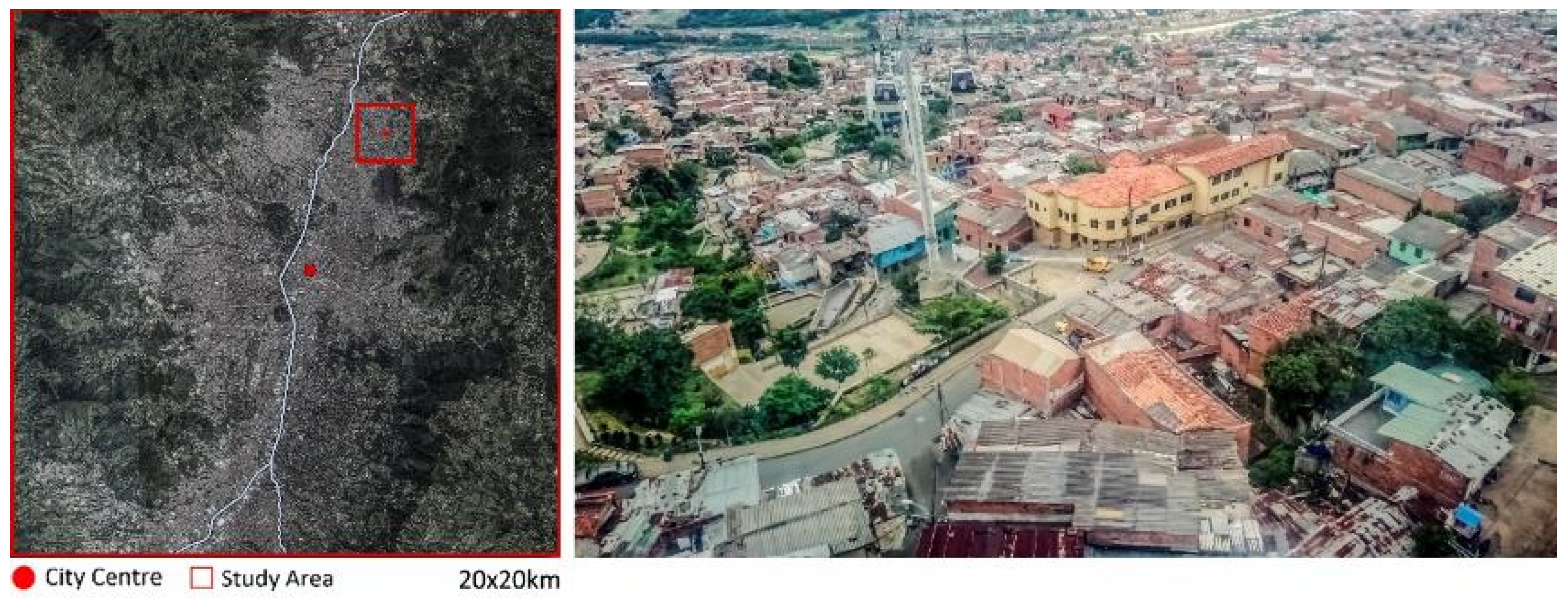
This study adopts a qualitative approach and focuses on a single case study in Medellin, which is the second-largest city in Colombia and the capital of the mountainous province of Antioquia. This study is part of broader research on the morphologies and incremental adaptations of informal settlements [46]. Data richness and accessibility to fieldwork were among the key criteria for the case study selection. Most pockets of informal morphologies in Medellin are located on the urban fringes along the eastern and western hillsides to the north, with only a few linear pockets located along the river [19]. Comuna Nororiental is located between the river and the escarpments in the northeast of the city. Figure 1 shows the location of the selected study area in Medellin.
Multiple research methods were deployed to explore the shaping of public space in the selected study area with a focus on spatial structures and incremental adaptations. Given that informal settlements are among the challenging urban environments to research, the attempt was to use unobtrusive methods during the fieldwork. The data on spatial structures and incremental adaptations were primarily collected through a mix of non-participant direct observation, extensive urban photography, and field notes. The selected study area was explored at two scales. The spatial structures were analysed at the neighbourhood scale with a focus on the urban morphologies, including access network, building density, and functional mix. The street-life density, public/private interface, and loose parts were explored at the street scale.
3. Case Study Analysis and Results
The city of Medellin has been transformed from the home of the Medellin Cartel in the 1980s and the homicide capital of the world in the 1990s to a booming city in the 21st century [47]. A rapid process of urbanisation since the 1950s has resulted in a fivefold growth of the population within about 3 decades [48] (p. 176). This has resulted in the emergence of large pockets of informal settlements on escarpments and peripheral lands through invasions and pirate developments [49]. Comuna Nororiental incorporates different forms of informality and accommodates one of the first core-plus housing projects in the 1960s, which started with the provision of 397 extendable units on the steep hillside in proximity to the river [50] (pp. 229–242). As Samper [51] (p. 78) argues, this project is particularly important as it shows the role of the state in initiating the urbanisation process in Comuna Nororiental and generating a path for the future.
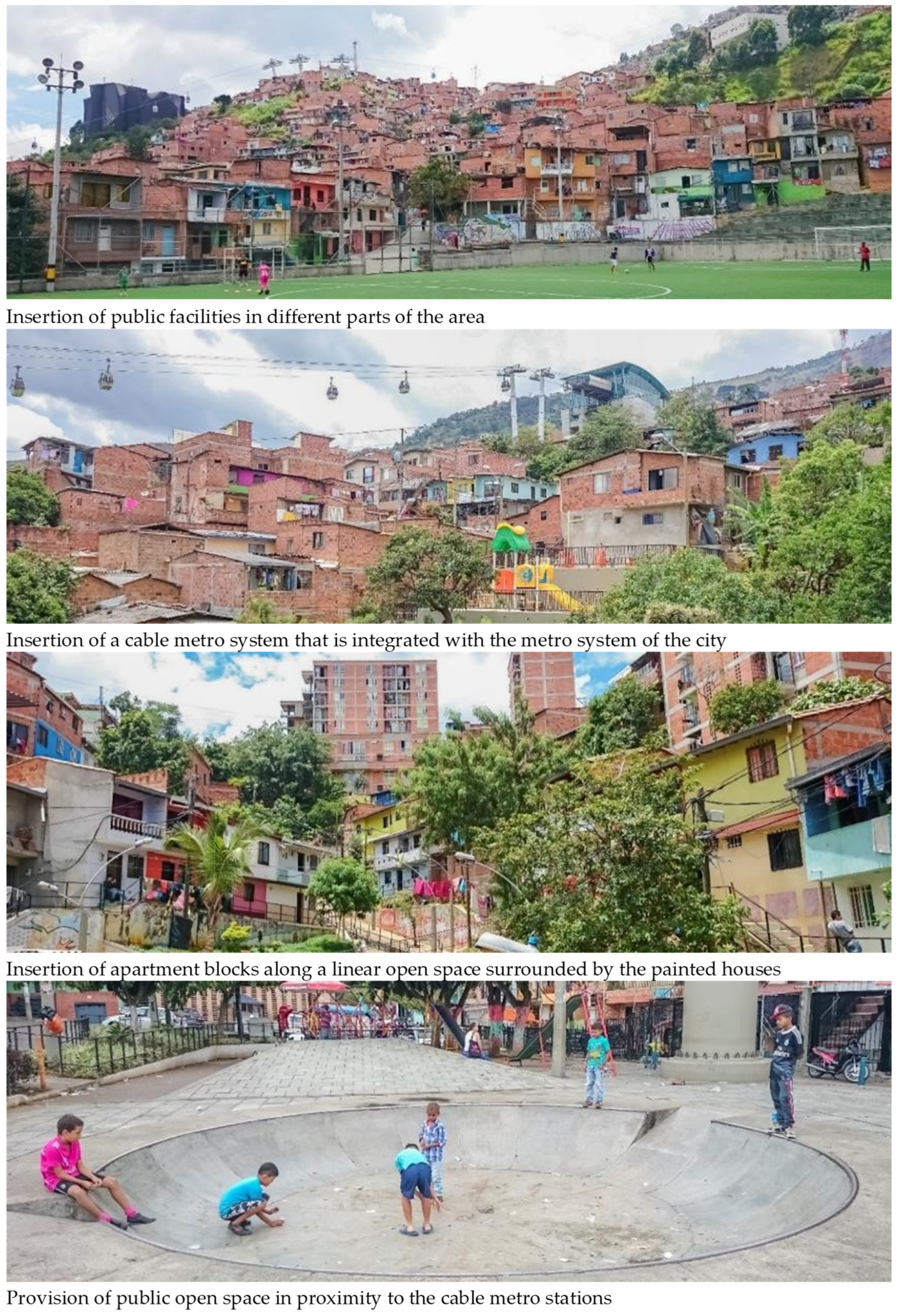
The city has experienced several place transformations since the mid-2000s by adopting an integral approach to the upgrading of informal settlements, development of urban infrastructures, and investments in public space, facilities, and education to address the challenges of socio-spatial inequality and violence. One of the key strategies known as “PUI” (Integral Urban Project) has been undertaken across disciplines, institutions, and scales. Comuna Nororiental has undergone through the PUI, incorporating public space, transportation, facilities, housing, and environmental improvements [52,53]. Figure 2 shows different aspects of this project in Comuna Nororiental. A cable metro was introduced in 2004 and integrated into the existing metro system to improve mobility within the reference area and connect the urban poor to the formal city [54] (p. 49). The cable metro has then become a key corridor along which the other projects were executed. The shaping of public space in the study area is further discussed with a particular focus on the spatial structures and increments of change.
3.1. Spatial Structures
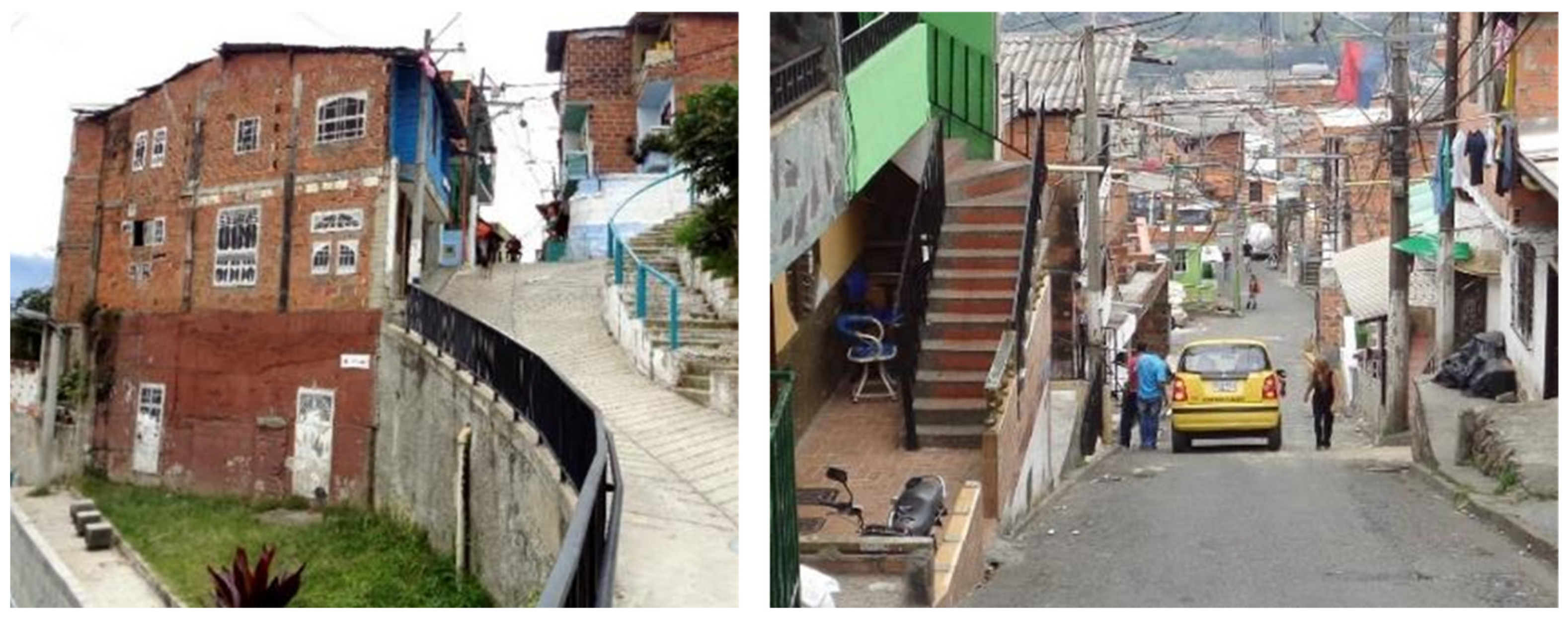
The coverage of the study area is about 60 percent, with a number of private open spaces located within plots. The building height mostly ranges from 2 to 3 storeys, with only a few one-storey buildings in the study area. The morphology produced through the process of semi-organised development incorporates several urban blocks ranging from about 70 × 70 m to 100 × 100 m, surrounded by a network of car access, forming an irregular grid. Lots are often loosely defined, with some narrow laneways providing access to the areas located deep within the urban blocks. Due to the steep topography of the area, multiple points of entry to certain buildings have become accessible at different levels (Figure 3, left). Most buildings incorporate setbacks, which work as a threshold between public and private territories (Figure 3, right). Setbacks generally vary in depth from about 0.5 m to 3 m.
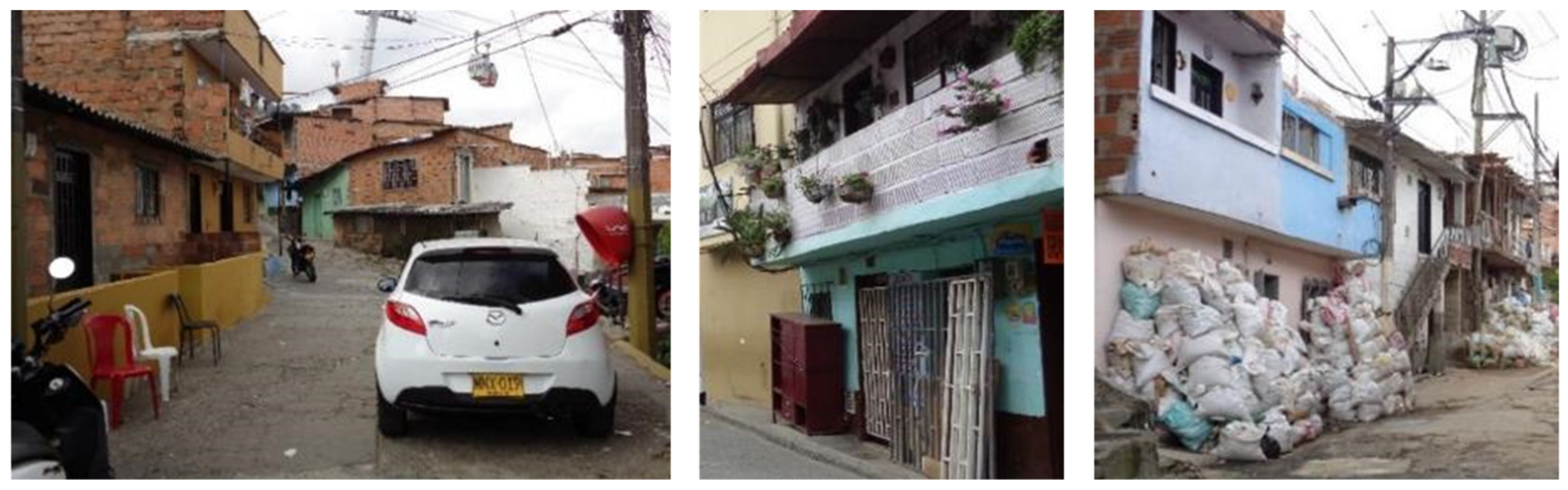
As Figure 4 (top) shows, the main streets are generally wide enough to accommodate cars as well as pedestrian flows. The access network incorporates a mix of a quasi-formal grid and a number of narrow laneways and dead ends. The area includes an average block perimeter of about 250 m. The lateral streets parallel to the contours are often busier than the uphill streets perpendicular to the contours, as the steep topography can constrain the flows of movement (Figure 4, top). The uphill laneways are often pedestrian-only. They connect lateral streets or form a dead-end providing access to residential units. The connecting laneways vary in width from about 1 m to 3 m (Figure 4, lower left, lower middle, and lower right). Physical traces of territorialisation associated with safety concerns and/or personalisation are often visible throughout the area, where many buildings have been fenced off from the public realm (Figure 5, left).
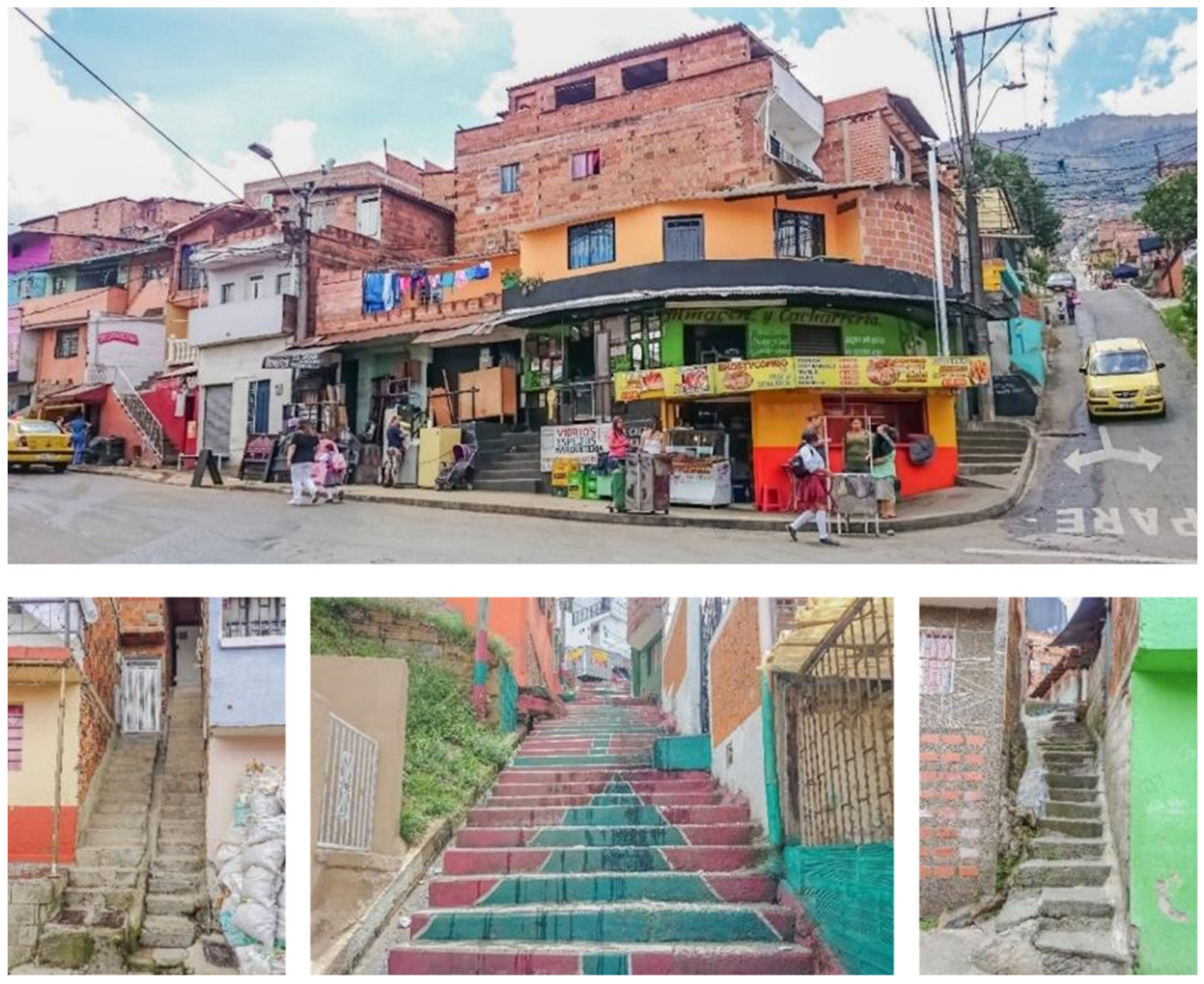
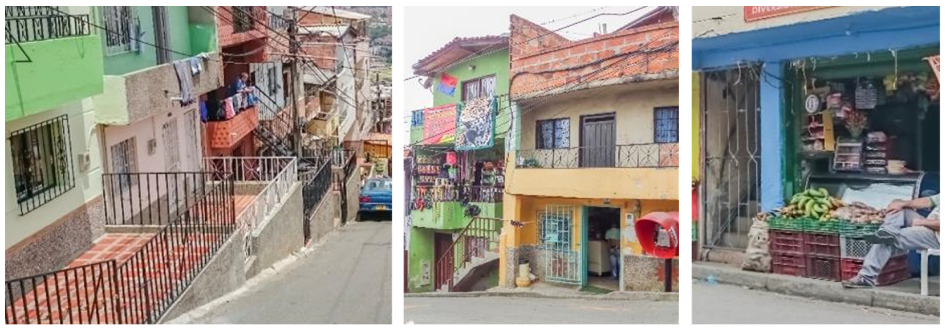
The study area is primarily residential, with several shops located in different parts of the settlement. Most of the shops are located along the lateral laneways where movement flows are usually more than the other parts of the settlement. The functional mix is mostly vertical in the buildings accommodating a mix of visit and live. The buildings located along the main streets consist of a ground-level shop and 1-2 upper-floor residential levels (Figure 5, middle). This is a particular form of vertical mix, which provides a socio-spatial possibility for enabling a direct connection between what can be considered as private and public territories through the ground-level shops as well as surveillance from the upper-floor residentials. The steep topography along the uphill streets has given rise to another variation, which includes a vertical mix of a first-floor shop, a residential unit at the ground level, and another residential unit on the second floor (Figure 5, middle). This enables somewhat convenient access to the residential unit located on the ground floor and more visibility for the shop located on the first floor.
The existing shops vary in terms of size and their relation to the public space and residential units. The shops located along the lateral streets often occupy the whole ground floor level, with residential units starting from the first floor (Figure 5, right). In this case, the residential units on the upper floors become physically accessible by means of internal/external staircases from the adjacent public space. Shops may also occupy the first floor of the buildings located along the uphill streets, accommodating pedestrian and vehicular movements (Figure 5, middle). Compared to the shops located at the ground level, the upper-floor shops are usually less accessible from the adjacent sidewalks. There are only a few stand-alone shops within the area.
The public/private urban interfaces vary along the laneways. Based on a typology of public/private interface in the context of informal settlements using the criteria of connectivity and proximity to the public space [13], most of the public/private interfaces in the study area can be considered as setbacks. There are also several impermeable and connected public/private interfaces. The impermeable interfaces are generally found at the ground level of corner buildings with blank walls (Figure 6, left). The public/private interfaces connected to the public space can be found at the ground level of residential units accessible from the public realm (Figure 6, middle). The porous public/private interfaces are not common within the settlement. An example of this type can only be found in some of the existing shops at the ground level (Figure 6, right). The setback condition works as a socio-spatial threshold accommodating loose parts and a diverse range of temporary activities, including storing, drying clothes, and parking vehicles, to name a few. A somewhat similar condition can also be found in some parts of the city where buildings incorporate a setback from the public space.
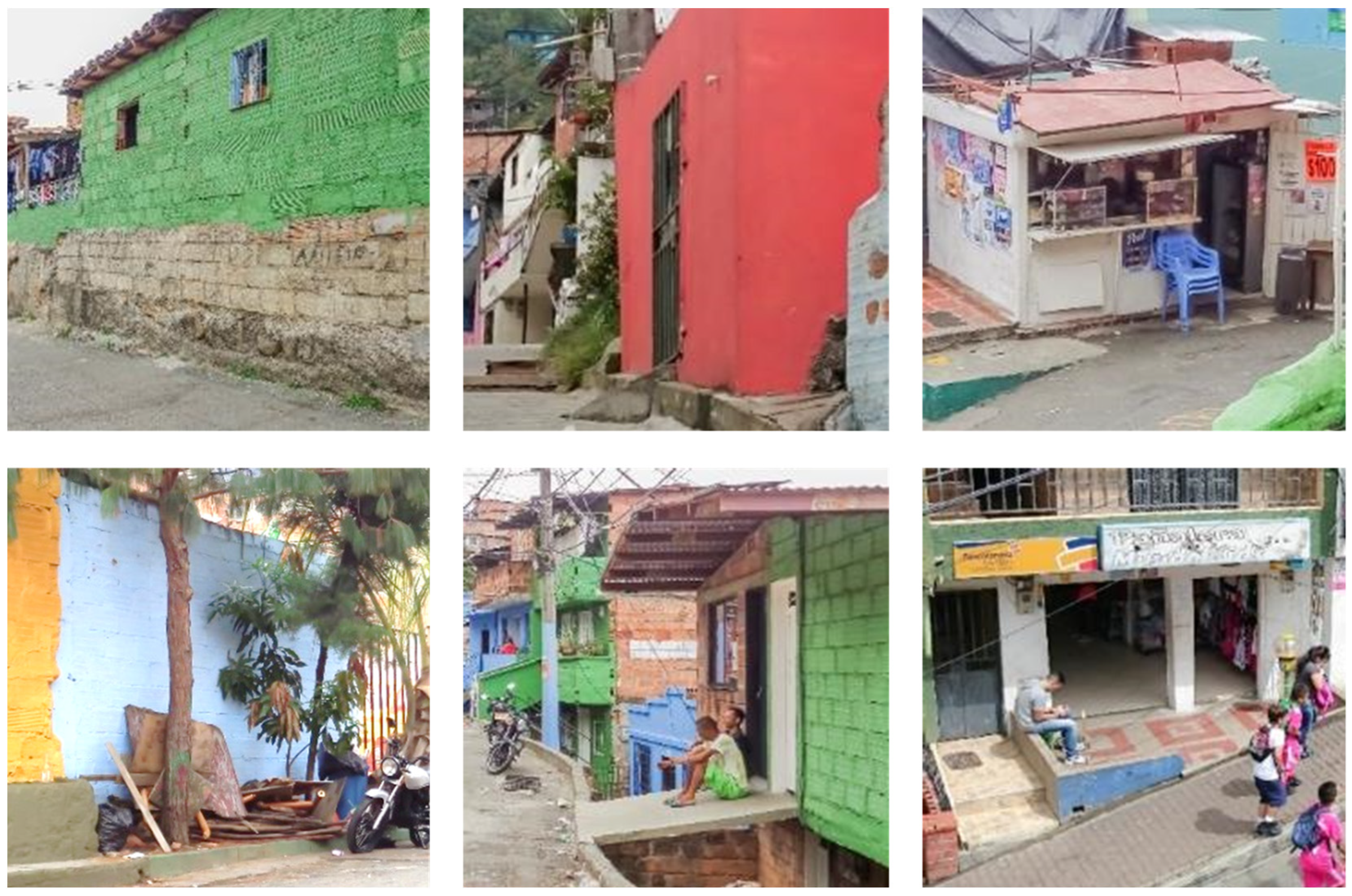
Various loose parts and activities take place along the edges of the public space within about 1m from building frontages (Figure 7). The loose parts in the context of the studied area mostly include parked vehicles, which temporarily occupy a part of the public realm in proximity to house fronts (Figure 7, left). The physical traces of home furniture are often visible in front of some of the houses located in proximity to local intersections (Figure 7, middle). The other prevailing loose parts in the study area are the stored materials and paraphernalia resulting in a temporal appropriation of public space (Figure 7, right). Stored materials are often less temporary than home furniture. Physical traces of certain activities, such as drying clothes, are not generally visible in the public space.
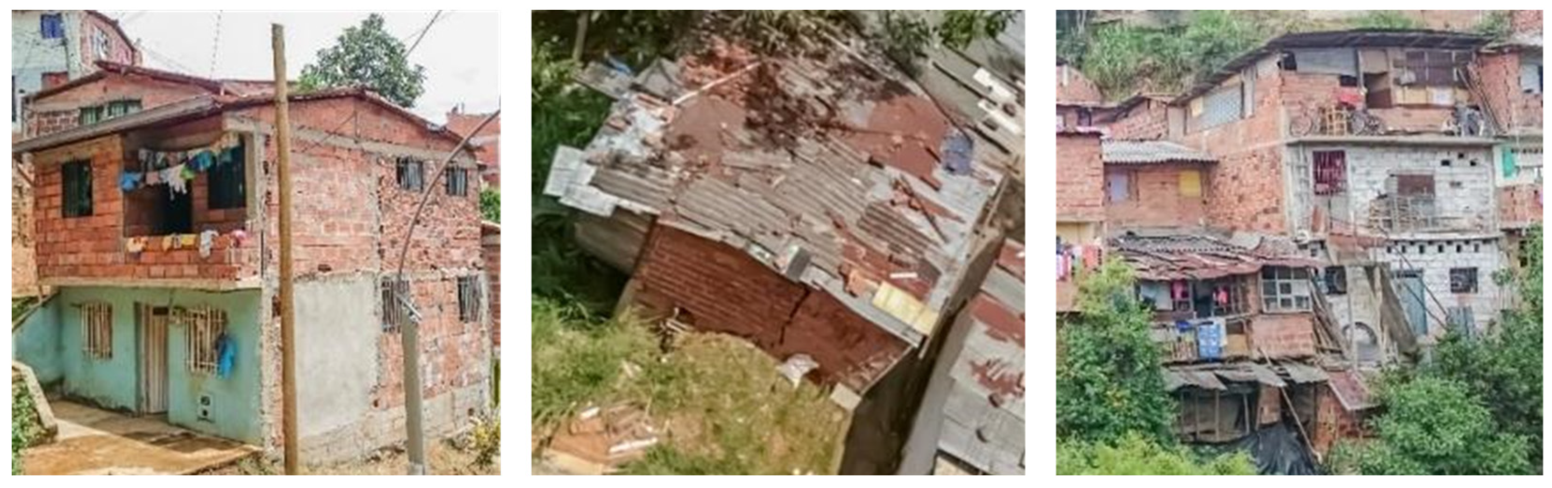
Building construction materials mostly include reinforced concrete, bricks, and cinder blocks (Figure 8, left). Temporary materials such as galvanised sheets and wood can also be found in a number of buildings located in proximity to steep creeks (Figure 8, middle). Figure 8 (right) shows the juxtaposition of a building with temporary materials next to another building, with a mix of relatively permanent materials at the lower levels and somewhat temporary construction materials on the upper floor. Buildings with relatively temporary materials often do not exceed more than 2 storeys (Figure 8, right).
3.2. Increments of Change
Adding multiple rooms is among the most common increments of change in Comuna Nororiental. It refers to the addition of multiple rooms in one go (Figure 9, left). The multiple-room addition often starts with relatively permanent materials from the beginning. It may also take place using temporary materials or a mix of both permanent and temporary materials. Construction materials generally need to be stored in locations close to the house before the commencement of the construction process. Physical traces of stored materials are often visible in different parts of the area where there is leftover space available in proximity to blank walls or under external staircases (Figure 9, upper right). The required construction materials are generally stored in proximity to the related house fronts (Figure 9, lower right).
Adding verandas, balconies, and/or roof terraces is a key increment of change. Verandas often appropriate parts of the public space to create a semi-private space (Figure 10, left). The added verandas are often located along the main streets. Most of the balconies providing the possibility of surveillance are also located along the streets (Figure 10, middle). Adding roof terraces is among the most common increments of change in Comuna Nororiental. Roof terraces are likely to be replaced by multiple rooms in the future as the required resources become available. Adding a roof terrace is about enclosing the existing rooftops to provide a horizontal enclosure by building half-walls and/or a vertical enclosure for an already horizontally enclosed roof terrace by adding a temporary roof with galvanised sheets (Figure 10, right). Verandas, balconies, and roof terraces provide possibilities for accommodating a diverse range of somewhat temporary activities, including storing materials and drying clothes, among others.
Adding external staircases is another increment of change, which may take place without adding multiple rooms to the existing buildings. This increment takes place where a single-unit building is divided into more than one unit with separate points of entry. This is an attempt to use the already available resources to generate more income, often through renting. A key investment here is to provide an external staircase and a separate entrance (Figure 11).
Another increment of change is about adding shops, which is a simultaneous change in terms of both functional mix and public/private urban interface (Figure 12, left). This increment of change takes place where the use of a building at the ground level changes from living to a mix of visiting and working. It can also transform the relations between private and public territories. This increment provides the possibility of generating more income through renting or creating jobs without transforming the overall building density. It can also contribute to street life by attracting pedestrian flows.
Changing from temporary materials to more permanent ones by replacing or repairing the construction materials is another increment (Figure 12, right). This increment of change can be followed by painting and/or rendering. It can also contribute to the construction quality and appearance of the buildings. The change from somewhat temporary to relatively permanent materials can also be considered as a form of informal upgrading.
4. Discussion
The spatial structures of the selected case study were analysed as part of this research. The materiality of place in Comuna Nororiental mainly includes a mix of informal buildings and quasi-formal access networks. The study area mostly includes 2-3 storey buildings. Vertical densification in informal settlements is by and large linked to the availability of the required resources as well as the extent to which the existing building structures can accommodate further additions [22]. The grain sizes in Comuna Nororiental are found to be generally larger than those in informal settlements elsewhere, such as the grain sizes in a case study in Pune, India [22]. Such differences are generally associated with the shaping of places over time. Comuna Nororiental has partly emerged through a process of semi-organised development with a loosely planned access network and a fairly limited mix of different grain sizes. Nevertheless, grain size does not necessarily predict building height. A comparison of the relations between building heights and grain sizes in the study area analysed in this paper and a case study in Pune, India [22] shows how the average building heights can relatively be close to each other in informal settlements with different grain sizes.
While the study area is primarily residential, a specific pattern of functional mix is found in proximity to the intersections and/or along the main laneways. The functional mix predominantly incorporates a mix of upper-floor residentials and ground-floor shops where greater exposure to pedestrian flows is more likely. The key point here is that informal settlements do not merely include residential units. This is in line with previous studies that documented how functional mix played out in informal settlements [18,19,55,56]. In addition to functional mix, certain practices such as painting building façades and/or personalising the public/private interfaces along the visible edges of buildings can lead to the emergence of formal mix, which is also associated with forms of expression along the edges of public space.
The access network accommodating the flows of movement, among others, primarily includes an irregular grid that emerged through a process of semi-organised development. This can be considered as an anticipatory process of shaping place and public space through which a quasi-formal network of access has been produced. In a study exploring the relations between formal and informal morphologies, Dovey and Kamalipour [11] illustrate how access networks may include informal and formal conditions across different contexts. While informal settlements may share some morphological similarities in a global context, different patterns of access network can be found across different informal settlements. For example, the access network in Comuna Nororiental is different from the access networks found in case studies in Pune, India [22] and Abuja, Nigeria [28]. The width of laneways also varies in relation to how the access networks have emerged and become consolidated. Comuna Nororiental incorporates a mix of wide streets accommodating cars and a number of narrow laneways. The width of the main streets can also be linked to an anticipatory process enabling car movement. The main laneways accommodating a high level of pedestrian flows are generally wider than the minor laneways permeating the urban blocks.
The access network is a primary public space in the study area. The way the access network works in informal settlements seems to be aligned with what Lofland [41] refers to as “parochial” realm since the public space in informal settlements can be characterised by a fairly strong sense of communality. It can also be considered as what Altman [57] calls “secondary” territory, which incorporates a degree of control by inhabitants. Drawing on case study research in Medellin, Colombia, Schwab [58] (p. 161) outlines that settlers are quite actively involved in the use and production of the comuna open spaces. The access networks in informal settlements are subject to a range of appropriations. While such appropriations can impact the performance of public space, the right of way is often protected in informal settlements [16]. The temporary appropriations of laneways are found as one of the key characteristics of public space in informal settlements [22]. Limited traces of excessive appropriations are found along the edges of the main streets in Comuna Nororiental. Loose parts in the study area generally take place in proximity to the edges of the public space. The extent to which the public space in formal settlements is subject to a range of appropriations can be linked to multiple factors, including the density, size, shape, and accessibility of the public open space.
The setback interface is found to be a common type of public/private interface along the main streets of the study area. The availability of a transitional space between the privacy of the inside and the publicity of the outside is particularly useful in informal settlements as it enables the accommodation of a range of loose parts and activities [13,55]. In compact informal settlements incorporating a mix of somewhat small grain sizes and narrow laneways, such transitional spaces are likely to appropriate parts of what is considered as the public space, particularly along its edges [22]. The setback types of public/private interface are more likely to take place where parts of the access network become wide enough to enable such spatial appropriations. This may explain the prevalence of the setback type of public/private interface with somewhat limited encroachments onto the public space in the study area where grain sizes are relatively larger, and streets are relatively wider than the other more compact case studies of informal settlements [19]. The prevalence of the setback type of public/private interface can also be linked to how the mixed morphologies might also resemble the image or the assumed appearance of what is considered as the formal city. Incorporating a transitional space between private and public territories is a characteristic that is often considered to be integral to certain housing developments in the context of the formal city.
While the public/private interfaces across the study area mostly enable a degree of connectivity between private and public territories, there are also some impermeable interfaces in Comuna Nororiental. The impermeable public/private interfaces are generally located along the laneways, accommodating a relatively low level of street life and/or on one side of corner buildings with limited access due to steep topography. The critical role of the public/private interface in enabling or constraining social and economic exchanges by controlling the degree to which private territories are connected to and/or close to the public space in informal settlements has been highlighted elsewhere [13]. Possibilities for economic and social exchanges can generally be enabled by accessible and/or porous public/private interfaces and constrained by impermeable interfaces. Buildings in the study area have an accessible public/private interface at least on one side to enable a degree of connectivity.
A mix of formal and informal processes is at play in the formation and transformation of informal settlements. As such, public spaces in informal settlements are continuously being shaped in relation to the needs, expectations, and desires of many, including the inhabitants. Certain increments of change, such as multiple-room addition, extension, spatial division, and material replacement, have been identified as informal adaptations in Comuna Nororiental. The increments of change are mediated by what is called “informal codes or rules” [16]. They also rely on an anticipatory process as they typically need to take place over a relatively short period. The selected case study has also been, in part, transformed through a cutting-edge and internationally recognised upgrading project focusing on public space, transport, and facilities, among others. Given that public spaces in informal settlements are being shaped through processes of formalisation and informalisation, one of the key lessons here is that even the implementation of major upgrading projects is unlikely to put an end to improvisation, adaptation, and self-organisation processes.
5. Conclusions
This paper has engaged with exploring the shaping of public space in the context of informal settlements by drawing on case study research in Medellin, Colombia. The attempt has been to provide a detailed account concerning the shaping of public space with a focus on exploring the spatial structures and increments of change in the selected study area. This paper also contributes a critical case study, which has experienced forms of informal and formal transformations. This section points to some of the key lessons and concludes by reflecting on the related implications.
One of the important lessons from Comuna Nororiental is about how adopting multiscale thinking can inform the upgrading and integration of informal settlements. The approach of the PUI includes the insertion of public facilities along with the development of public spaces in proximity to the cable metro. The related projects range from the micro scale, which includes the insertion of certain buildings such as library and school, to the meso scale, which involves the provision of a public open space network and environmental improvements, and to the macro scale, which includes the cable metro and its connectivity to the existing metro system. Adopting a multiscale approach is associated with understanding informal settlement as a way of shaping place and public space across multiple scales that cannot be effectively explored and addressed in isolation from the related contexts. Enabling connectivity between the cable metro and the existing metro system is particularly important as it has provided possibilities for forms of integration into the broader city. The development of public facilities and urban open spaces through a number of interrelated projects has also provided opportunities for chance encounter and social interaction in public spaces. A key point here is to think about developing a sophisticated approach to the upgrading and integration of informal settlements that works across different scales and goes beyond merely focusing on housing.
Producing mixed morphologies can be considered as an attempt to enable a degree of visual resemblance with what is considered as the formal city, which may possibly facilitate future forms of formalisation and/or upgrading. As Huchzermeyer et al. [59] argue, adherence to the patterns reflecting the layout of the formal city is related to the land availability and the expectation of a forthcoming upgrading. Medellin incorporates large pockets of informal, formal mix, and informal mix morphologies [19]. Informal morphologies are mostly located along the hillsides and close to the urban fringes. Pockets of mixed morphologies, to some extent, resemble the appearance of what is considered as the formal city. Such resemblances are, in part, related to how the constructed images of the formal city can be imitated through anticipatory processes of semi-organised development. Such morphological resemblances to the formal city may also provide possibilities for design interventions without wholesale demolition. It has been pointed out that introducing change is more challenging in more consolidated informal settlements [60] (p. 171). Possibilities for major urban transformations are likely to become more constrained as informal settlements become more consolidated.
Much of the shaping of place and public space in informal settlements can be considered as “unfinished” in the sense that their “incompleteness” enables a degree of flexibility for possible adaptations in relation to the individual and collective needs and desires of inhabitants. Incomplete forms or objects are considered as one of the key characteristics of what Sennett [61] calls “the open city”. Drawing on the progressive conceptualisation of place by Massey [62] and the notion of “place as assemblage” by Dovey [63], this article argues that public spaces in informal settlements are in states of becoming in the sense that they are in continuous processes of adaptation enabling them to maintain their openness, flexibility, and looseness, among others. As such, they are not static and do not have single identities. Becoming unfinished can be understood as a way of making, unmaking, and remaking places and public spaces in informal settlements. Their incompleteness can then be considered as an asset for managing a range of uncertainties associated with how forms of urban informality play out by enabling possibilities for change and sustaining resilience.
The identity of place and symbolic capital of informal settlements can change in the processes of urban transformation through which certain images are being made, unmade, and remade. In the case of Medellin, design interventions are particularly associated with the adaptations of place identity in relation to the constructed images of informal settlement. As Brand and Dávila [64] (p. 658) point out, the aesthetic experience provided by the cable metro entails a symbolic value, which also gives rise to a sense of integration into what is considered as the formal city. The area has partly been opened up to the gaze of international tourists as well as the formal city, which may contribute to the alteration of place identity and image, particularly along the corridor of the cable metro. A study by Kamalipour and Dovey [12] has shown how certain forms of visibility, such as public overview, emerged in relation to the development of the cable metro in Comuna Nororiental. Nevertheless, as Perlman [65] (p. 30) argues in the context of researching favelas, there is often little doubt regarding the distinctions between the informal settlements and other parts of the city even after extensive projects of upgrading as their visual markers are by and large unmistakable.
6. Limitations and Future Research
A number of limitations were identified in the process of data collection and analysis. Exploring private spaces and the seemingly impenetrable parts of the access network was avoided during the fieldwork. Since the interior spaces of buildings were not accessible, it was only possible to explore the functional mix where some physical traces indicating different uses were visible from the public space. Although the access network largely appeared to be permeable on aerial images, certain parts of the access network did not seem penetrable on the ground primarily due to a range of socio-spatial clues, which discouraged further explorations on the ground. While urban photography was quite useful in addressing the possible gaps of direct observation, it had limitations regarding how much could actually fit in the frame, particularly in certain parts of the study area, such as narrow laneways. This study is primarily based on empirical research for which international fieldwork was undertaken in 2015. It was not entirely possible for the researcher to access the related data before and/or after the fieldwork. Thus, the collected data are limited to the duration of the fieldwork. Undertaking a longitudinal exploration remains a limitation of this study and a task for future research. Future studies can investigate the relationship between the production of forms and meanings in relation to each other in the context of informal settlements. Comparative studies across different places can also explore various types of public space in informal settlements with a focus on how they are being shaped in a global context.
Funding
The author received APA, IPRS, and RTP scholarships for his study at the University of Melbourne.
Data Availability Statement
The relevant data are primarily contained within the article.
Acknowledgments
This paper is derived from a broader study by the author entitled Urban Informalogy: The Morphologies and Incremental Transformations of Informal Settlements at the University of Melbourne [46]. The author wishes to thank the reviewers for their time, incisive critique, and helpful suggestions.
Conflicts of Interest
The author declares no conflict of interest. The funders had no role in the design of the study; in the collection, analyses, or interpretation of data; in the writing of the manuscript, or in the decision to publish the results.
References
- UN-Habitat. The State of the World’s Cities Report 2006/7: The Millennium Development Goals and Urban Sustainability; Earthscan: London, UK, 2006. [Google Scholar]
- Davis, M. Planet of Slums; Verso: New York, NY, USA, 2006. [Google Scholar]
- Neuwirth, R. Shadow Cities: A Billion Squatters, a New Urban World; Routledge: New York, NY, USA, 2005. [Google Scholar]
- Arefi, M. Learning from Informal Settlements in Iran; Palgrave Macmillan: Cham, Switzerland, 2018. [Google Scholar]
- Perlman, J.E. Six Misconceptions about Squatter Settlements. Dev. Seeds Chang. 1986, 4, 40–44. [Google Scholar]
- McGuirk, J. Radical Cities: Across Latin America in Search of a New Architecture; Verso: London, UK, 2014. [Google Scholar]
- Dovey, K.; King, R. Forms of Informality: Morphology and Visibility of Informal Settlements. Built Environ. 2011, 37, 11–29. [Google Scholar] [CrossRef] [Green Version]
- Mukhija, V. Upgrading Housing Settlements in Developing Countries: The Impact of Existing Physical Conditions. Cities 2001, 18, 213–222. [Google Scholar] [CrossRef]
- Lara, F.L. The Form of the Informal: Investigating Brazilian Self-Built Housing Solutions. In Rethinking the Informal City: Critical Perspectives from Latin America; Hernández, F., Kellett, P., Allen, L.K., Eds.; Berghahn Books: New York, NY, USA, 2010; pp. 23–38. [Google Scholar]
- Ribeiro, G. An Ecological Approach to the Study of Urban Spaces: The Case of a Shantytown in Brasilia. J. Archit. Plan. Res. 1997, 14, 289–300. [Google Scholar]
- Dovey, K.; Kamalipour, H. Informal/Formal Morphologies. In Mapping Urbanities: Morphologies, Flows, Possibilities; Dovey, K., Pafka, E., Ristic, M., Eds.; Routledge: New York, NY, USA, 2018; pp. 223–248. [Google Scholar] [CrossRef]
- Kamalipour, H.; Dovey, K. Mapping the Visibility of Informal Settlements. Habitat Int. 2019, 85, 63–75. [Google Scholar] [CrossRef]
- Kamalipour, H. Mapping Urban Interfaces: A Typology of Public/Private Interfaces in Informal Settlements. Spaces Flows Int. J. Urban Extra Urban Stud. 2017, 8, 1–12. [Google Scholar] [CrossRef]
- Jones, P. Distance and Proximity Matters: Understanding Housing Transformation through Micro-Morphology in Informal Settlements. Int. J. Hous. Policy 2021, 21, 169–195. [Google Scholar] [CrossRef]
- Jones, P. The Shaping of Form and Structure in Informal Settlements: A Case Study of Order and Rules in Lebak Siliwangi, Bandung, Indonesia. J. Reg. City Plan. 2019, 30, 43–61. [Google Scholar] [CrossRef]
- Kamalipour, H.; Dovey, K. Incremental Production of Urban Space: A Typology of Informal Design. Habitat Int. 2020, 98, 102133. [Google Scholar] [CrossRef]
- Suhartini, N.; Jones, P. Better Understanding Self-Organizing Cities: A Typology of Order and Rules in Informal Settlements. J. Reg. City Plan. 2020, 31, 237–263. [Google Scholar] [CrossRef]
- Kamalipour, H. Forms of Informality and Adaptations in Informal Settlements. ArchNet-IJAR Int. J. Archit. Res. 2016, 10, 60–75. [Google Scholar] [CrossRef]
- Kamalipour, H.; Dovey, K. Incremental Urbanisms. In Mapping Urbanities: Morphologies, Flows, Possibilities; Dovey, K., Pafka, E., Ristic, M., Eds.; Routledge: New York, NY, USA, 2018; pp. 249–267. [Google Scholar] [CrossRef]
- Samper, J.; Shelby, J.A.; Behary, D. The Paradox of Informal Settlements Revealed in an ATLAS of Informality: Findings from Mapping Growth in the Most Common Yet Unmapped Forms of Urbanization. Sustainability 2020, 12, 9510. [Google Scholar] [CrossRef]
- Simone, A. Emergency Democracy and the “Governing Composite”. Soc. Text 2008, 26, 13–33. [Google Scholar] [CrossRef] [Green Version]
- Kamalipour, H. Improvising Places: The Fluidity of Space in Informal Settlements. Sustainability 2020, 12, 2293. [Google Scholar] [CrossRef] [Green Version]
- Hamdi, N. Small Change: About the Art of Practice and the Limits of Planning in Cities; Earthscan: London, UK, 2004. [Google Scholar]
- Greene, M.; Rojas, E. Incremental Construction: A Strategy to Facilitate Access to Housing. Environ. Urban. 2008, 20, 89–108. [Google Scholar] [CrossRef] [Green Version]
- Rudlin, D.; Hemani, S. Climax City: Masterplanning and the Complexity of Urban Growth; RIBA Publishing: London, UK, 2019. [Google Scholar]
- Suhartini, N.; Jones, P. Beyond the Informal: Understanding Self-Organized Kampungs in Indonesia; Springer: Cham, Switzerland, 2023. [Google Scholar]
- Dovey, K.; van Oostrum, M.; Chatterjee, I.; Shafique, T. Towards a Morphogenesis of Informal Settlements. Habitat Int. 2020, 104, 102240. [Google Scholar] [CrossRef]
- Kamalipour, H.; Iranmanesh, A. Morphogenesis of Emerging Settlements: Mapping Incremental Urbanism. Land 2021, 10, 89. [Google Scholar] [CrossRef]
- Thinh, N.K.; Kamalipour, H. The Morphogenesis of Villages-in-the-City: Mapping Incremental Urbanism in Hanoi City. Habitat Int. 2022, 130, 102706. [Google Scholar] [CrossRef]
- Carmona, M. Public Places Urban Spaces: The Dimensions of Urban Design, 3rd ed.; Routledge: New York, NY, USA, 2021. [Google Scholar]
- Mehta, V.; Palazzo, D. Introduction. In Companion to Public Space; Mehta, V., Palazzo, D., Eds.; Routledge: London, UK, 2020; pp. 1–3. [Google Scholar]
- Banerjee, T. The Idea of the Urban Commons: Challenges of Enclosure, Encroachment, and Exclusion. In Companion to Public Space; Mehta, V., Palazzo, D., Eds.; Routledge: London, UK, 2020; pp. 499–512. [Google Scholar]
- Jacobs, J. The Death and Life of Great American Cities; Random House: New York, NY, USA, 1961. [Google Scholar]
- Whyte, W.H. The Social Life of Small Urban Spaces; The Conservation Foundation: Washington, DC, USA, 1980. [Google Scholar]
- Gehl, J. Life between Buildings: Using Public Space; Van Nostrand Reinhold: New York, NY, USA, 1987. [Google Scholar]
- Carr, S.; Francis, M.; Rivlin, L.; Stone, A. Public Space; Cambridge University Press: Cambridge, UK, 1992. [Google Scholar]
- Brown, A. (Ed.) Contested Space: Street Trading, Public Space, and Livelihoods in Developing Cities; ITDG: London, UK, 2006. [Google Scholar]
- Calderon, C.; Hernández-García, J. Bottom-Up Public Space Design and Social Cohesion: The Case of a Self-Developed Park in an Informal Settlement of Bogotá. In Public Space Design and Social Cohesion; Aelbrecht, P., Stevens, Q., Eds.; Routledge: New York, NY, USA, 2019; pp. 140–157. [Google Scholar]
- Hernández-García, J. Public Space in Informal Settlements: The Barrios of Bogotá; Cambridge Scholars Publishing: Newcastle upon Tyne, UK, 2013. [Google Scholar]
- Dovey, K. Urban Design Thinking: A Conceptual Toolkit; Bloomsbury: New York, NY, USA, 2016. [Google Scholar]
- Lofland, L.H. The Public Realm: Exploring the City’s Quintessential Social Territory; Aldine de Gruyter: Hawthorne, NY, USA, 1998. [Google Scholar]
- Lynch, K. Good City Form; MIT Press: Cambridge, MA, USA, 1981. [Google Scholar]
- Franck, K.; Stevens, Q. (Eds.) Loose Space: Possibility and Diversity in Urban Life; Routledge: London, UK, 2007. [Google Scholar]
- Hou, J. (Ed.) Insurgent Public Space: Guerrilla Urbanism and the Remaking of Contemporary Cities; Routledge: New York, NY, USA, 2010. [Google Scholar]
- Van Oostrum, M. Appropriating Public Space: Transformations of Public Life and Loose Parts in Urban Villages. J. Urban. Int. Res. Placemaking Urban Sustain. 2022, 15, 84–105. [Google Scholar] [CrossRef]
- Kamalipour, H. Urban Informalogy: The Morphologies and Incremental Transformations of Informal Settlements. Ph.D. Dissertation, University of Melbourne, Melbourne, Australia, 2017. Available online: http://hdl.handle.net/11343/197684 (accessed on 12 February 2023).
- Hylton, F. Medellin’s Makeover. New Left Rev. 2007, 44, 71–89. [Google Scholar]
- Mendieta, E. Medellín and Bogotá: The Global Cities of the Other Globalization. City 2011, 15, 167–180. [Google Scholar] [CrossRef]
- Echeverri Restrepo, A.; Orsini, F.M. Informality and Social Urbanism in Medellin. In Medellin: Environment, Urbanism and Society; Hermelin, M., Echeverri Restrepo, A., Giraldo Ramirez, J., Eds.; Urbam-Universidad EAFIT: Medellin, Colombia, 2012; pp. 132–156. [Google Scholar]
- Caminos, H.; Turner, J.F.C.; Steffian, J.A. Urban Dwelling Environments: An Elementary Survey of Settlements for the Study of Design Determinants; MIT Press: Cambridge, MA, USA, 1969. [Google Scholar]
- Samper, J. The Politics of Peace Process in Cities in Conflict: The Medellin Case as a Best Practice. Master’s Thesis, Massachusetts Institute of Technology, Cambridge, MA, USA, 2010. Available online: http://hdl.handle.net/1721.1/59768 (accessed on 12 February 2023).
- Alcaldía de Medellín, E.D.U.; Urbam-Universidad EAFIT. Medellín Modelo de Transformación Urbana, Proyecto Urbano Integral—PUI—En La Zona Nororiental; Urbam-Universidad EAFIT: Medellín, Colombia, 2014. [Google Scholar]
- Blanco, C.; Kobayashi, H. Urban Transformation in Slum Districts through Public Space Generation and Cable Transportation at Northeastern Area: Medellin, Colombia. J. Int. Soc. Res. 2009, 2, 75–90. [Google Scholar]
- Bocarejo, J.P.; Portilla, I.J.; Velásquez, J.M.; Cruz, M.N.; Peña, A.; Oviedo, D.R. An Innovative Transit System and Its Impact on Low Income Users: The Case of the Metrocable in Medellín. J. Transp. Geogr. 2014, 39, 49–61. [Google Scholar] [CrossRef]
- Bhatt, V.; Rybczynski, W. How the Other Half Builds. In Time-Saver Standards in Urban Design; Watson, D., Plattus, A.J., Shibley, R.G., Eds.; McGraw-Hill: New York, NY, USA, 2003; pp. 1.3.1–1.3.12. [Google Scholar]
- Kellett, P.; Tipple, A.G. The Home as Workplace: A Study of Income-Generating Activities within the Domestic Setting. Environ. Urban. 2000, 12, 203–214. [Google Scholar] [CrossRef]
- Altman, I. The Environment and Social Behavior: Privacy, Personal Space, Territory, Crowding; Brooks/Cole: Monterey, CA, USA, 1975. [Google Scholar]
- Schwab, E. Spatial Justice and Informal Settlements: Integral Urban Projects in the Comunas of Medellín; Emerald Group Publishing: Bingley, UK, 2018. [Google Scholar]
- Huchzermeyer, M.; Karam, A.; Maina, M. Informal Settlements. In Changing Space, Changing City: Johannesburg after Apartheid; Harrison, P., Götz, G., Todes, A., Wray, C., Eds.; Wits University Press: Johannesburg, South Africa, 2014; pp. 154–175. [Google Scholar]
- Gouverneur, D. Making a Difference in the Predominantly Informal City. In Slums: How Informal Real Estate Markets Work; Birch, E.L., Chattaraj, S., Wachter, S.M., Eds.; University of Pennsylvania Press: Philadelphia, PA, USA, 2016; pp. 155–176. [Google Scholar]
- Sennett, R. The Open City. In In the Post-Urban World; Haas, T., Westlund, H., Eds.; Routledge: London, UK, 2017; pp. 97–106. [Google Scholar]
- Massey, D. Space, Place, and Gender; University of Minnesota Press: Minneapolis, MN, USA, 1994. [Google Scholar]
- Dovey, K. Becoming Places: Urbanism/Architecture/Identity/Power; Routledge: London, UK, 2010. [Google Scholar]
- Brand, P.; Dávila, J.D. Mobility Innovation at the Urban Margins. City 2011, 15, 647–661. [Google Scholar] [CrossRef]
- Perlman, J.E. Favela: Four Decades of Living on the Edge in Rio de Janeiro; Oxford University Press: Oxford, UK, 2010. [Google Scholar]
Figure 1.
The study area in Medellin, Colombia. Satellite image (left): Google Earth. Photo (right): Hesam Kamalipour.
Figure 1.
The study area in Medellin, Colombia. Satellite image (left): Google Earth. Photo (right): Hesam Kamalipour.

Figure 2.
The integration of public facilities, transport, housing, and public space in the PUI. Photos: Hesam Kamalipour.
Figure 2.
The integration of public facilities, transport, housing, and public space in the PUI. Photos: Hesam Kamalipour.

Figure 3.
Multiple entries at different levels (left); setbacks facing the streets accommodating vehicular and pedestrian flows (right). Photos: Hesam Kamalipour.
Figure 3.
Multiple entries at different levels (left); setbacks facing the streets accommodating vehicular and pedestrian flows (right). Photos: Hesam Kamalipour.

Figure 4.
Lateral streets are often busier than the uphill ones (top); the pedestrian-only parts of the access network, including dead-end laneways (lower left), wide pedestrian-only laneways connecting streets (lower middle), and narrow walk-up laneways (lower right). Photos: Hesam Kamalipour.
Figure 4.
Lateral streets are often busier than the uphill ones (top); the pedestrian-only parts of the access network, including dead-end laneways (lower left), wide pedestrian-only laneways connecting streets (lower middle), and narrow walk-up laneways (lower right). Photos: Hesam Kamalipour.

Figure 5.
Fenced-off buildings in relation to public space (left); a vertical mix including residential units and shops (middle); an upper-floor residential unit with an internal staircase (right). Photos: Hesam Kamalipour.
Figure 5.
Fenced-off buildings in relation to public space (left); a vertical mix including residential units and shops (middle); an upper-floor residential unit with an internal staircase (right). Photos: Hesam Kamalipour.

Figure 6.
Different types of public/private interfaces based on Kamalipour [13]: impermeable (left); accessible (middle); porous (right). Photos: Hesam Kamalipour.
Figure 6.
Different types of public/private interfaces based on Kamalipour [13]: impermeable (left); accessible (middle); porous (right). Photos: Hesam Kamalipour.

Figure 7.
Different loose parts include construction materials (right), furniture (middle and left), and parked vehicles (left). Photos: Hesam Kamalipour.
Figure 7.
Different loose parts include construction materials (right), furniture (middle and left), and parked vehicles (left). Photos: Hesam Kamalipour.

Figure 8.
Construction materials: a building with temporary materials next to a building with a vertical mix of temporary and permanent materials (right); an informal structure with temporary materials along a creek (middle); a house with durable construction materials (left). Photos: Hesam Kamalipour.

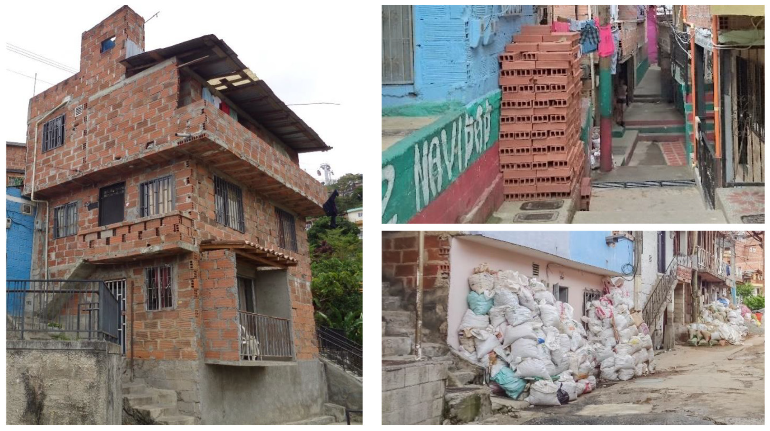
Figure 9.
Adding multiple rooms: adding permanent rooms (left); storing materials against a blank wall (upper right); storing material in front of a house (lower right). Photos: Hesam Kamalipour.
Figure 9.
Adding multiple rooms: adding permanent rooms (left); storing materials against a blank wall (upper right); storing material in front of a house (lower right). Photos: Hesam Kamalipour.

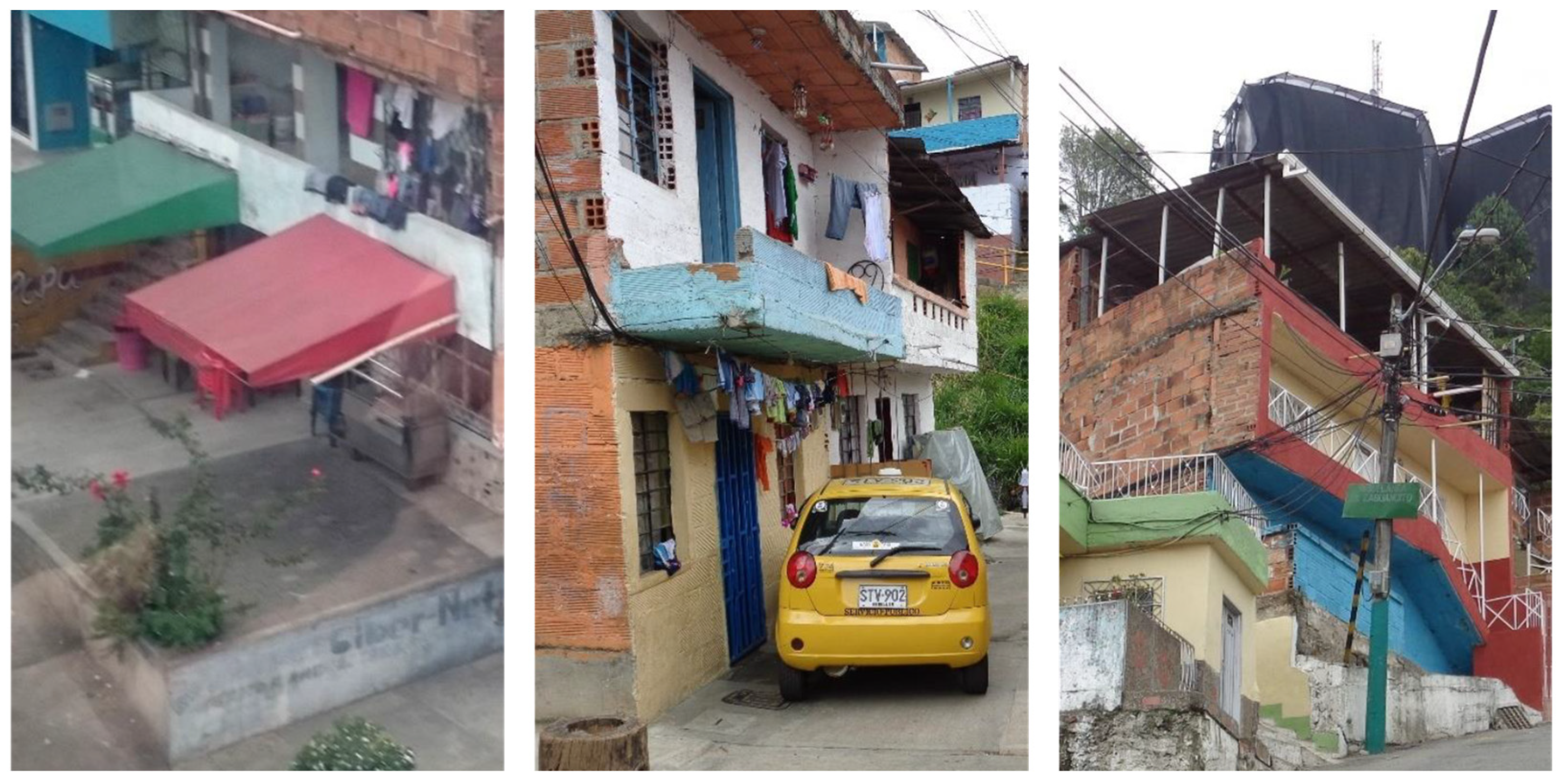
Figure 10.
Extending the existing structures by adding a roof terrace (right), a balcony (middle), or a veranda (left). Photos: Hesam Kamalipour.
Figure 10.
Extending the existing structures by adding a roof terrace (right), a balcony (middle), or a veranda (left). Photos: Hesam Kamalipour.

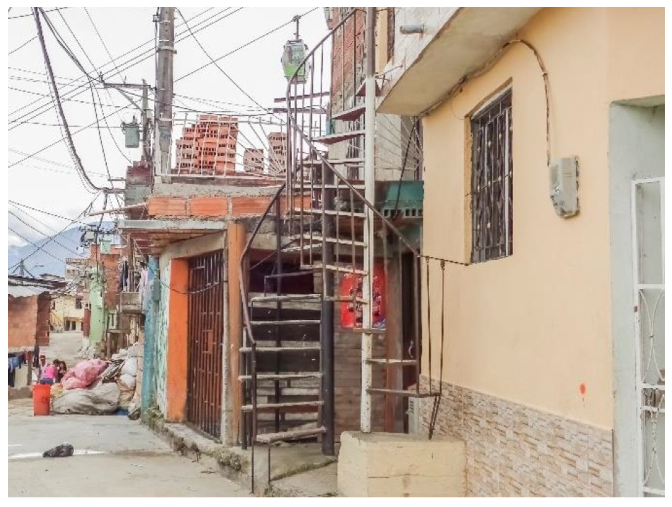
Figure 11.
Dividing units by adding external staircases. Photo: Hesam Kamalipour.

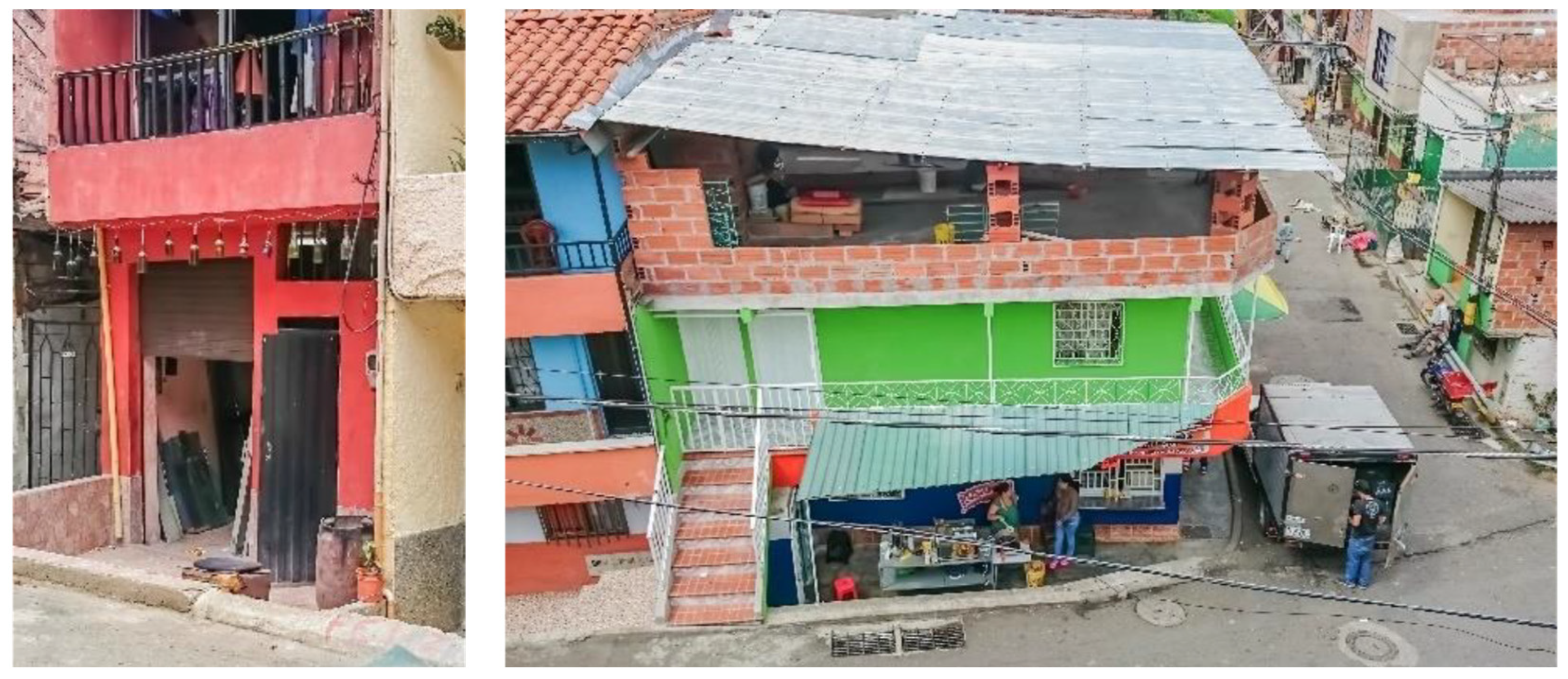
Figure 12.
Enabling a mix of living, visiting, and working (left); from somewhat temporary to relatively permanent construction materials (right). Photos: Hesam Kamalipour.
Figure 12.
Enabling a mix of living, visiting, and working (left); from somewhat temporary to relatively permanent construction materials (right). Photos: Hesam Kamalipour.

Disclaimer/Publisher’s Note: The statements, opinions and data contained in all publications are solely those of the individual author(s) and contributor(s) and not of MDPI and/or the editor(s). MDPI and/or the editor(s) disclaim responsibility for any injury to people or property resulting from any ideas, methods, instructions or products referred to in the content. |
© 2023 by the author. Licensee MDPI, Basel, Switzerland. This article is an open access article distributed under the terms and conditions of the Creative Commons Attribution (CC BY) license (https://creativecommons.org/licenses/by/4.0/).
Share and Cite
MDPI and ACS Style
Kamalipour, H. Shaping Public Space in Informal Settlements: A Case Study. Sustainability 2023, 15, 3781. https://doi.org/10.3390/su15043781
AMA Style
Kamalipour H. Shaping Public Space in Informal Settlements: A Case Study. Sustainability. 2023; 15(4):3781. https://doi.org/10.3390/su15043781
Chicago/Turabian StyleKamalipour, Hesam. 2023. "Shaping Public Space in Informal Settlements: A Case Study" Sustainability 15, no. 4: 3781. https://doi.org/10.3390/su15043781
Note that from the first issue of 2016, this journal uses article numbers instead of page numbers. See further details here.