Article

Use of Analytic Hierarchy Process Method to Identify Potential Rainwater Harvesting Sites: Design and Financial Strategies in Taxco de Alarcón, Southern Mexico

by
Blanca Itzany Rivera Vázquez
1,
Edith Rosalba Salcedo Sánchez
2,*,
Juan Manuel Esquivel Martínez
2,*,
Miguel Ángel Gómez Albores
3,
Felipe Gómez Noguez
4,
Carina Gutiérrez Flores
5 and
Oscar Talavera Mendoza
6
1
Maestría en Recursos Naturales y Ecología, Facultad de Ecología Marina, Universidad Autónoma de Guerrero, Av. Gran Vía Tropical 20, Fraccionamiento Las Playas, Acapulco 39390, Guerrero, Mexico
2
Consejo Nacional de Ciencia y Tecnología, Escuela Superior de Ciencias de la Tierra, Universidad Autónoma de Guerrero, Ex-Hacienda de San Juan Bautista s/n, Taxco el Viejo 40323, Guerrero, Mexico
3
Instituto Interamericano de Tecnología y Ciencias del Agua (IITCA), Universidad Autónoma del Estado de México, Ixtlahuaca de Rayón 110, Toluca de Lerdo 50110, Estado de Mexico, Mexico
4
Facultad de Ciencias Químico Biológicas, Universidad Autónoma de Guerrero, Lázaro Cárdenas, El Centenario, Chilpancingo de los Bravo 39086, Guerrero, Mexico
5
Consejo Nacional de Ciencia y Tecnología, Escuela Superior en Desarrollo Sustentable, Universidad Autónoma de Guerrero, Carretera Nacional Tecpan-Zihuatanejo, Col. Las Tunas, Tecpan de Galeana 40900, Guerrero, Mexico
6
Escuela Superior de Ciencias de la Tierra, Universidad Autónoma de Guerrero, Ex-Hacienda San Juan Bautista s/n, Taxco el Viejo 40323, Guerrero, Mexico
*
Authors to whom correspondence should be addressed.
Sustainability 2023, 15(10), 8220; https://doi.org/10.3390/su15108220
Submission received: 8 April 2023 / Revised: 3 May 2023 / Accepted: 15 May 2023 / Published: 18 May 2023
(This article belongs to the Topic Hydrology and Water Resources Management)

Abstract

:
Mexico is among the countries that are facing the greatest water stress, where factors such as climate change, contamination of surface water, groundwater sources, and inefficient management have limited the availability of water resources. Consequently, new supply sources need to be implemented. Rainwater harvesting systems (RHS) are viable and sustainable alternatives, the implementation of which primarily depends on identifying suitable sites and applying technologies that are appropriate for different users. This research used the Analytical Hierarchy Process (AHP) technique in a GIS environment to select the optimal sites for designing RHS, taking into account hydrological, biophysical, and socioeconomic criteria. After determining the ideal sites, the study presents proposals and costs for the design of an urban and rural RHS based on the characteristics of the region and the needs of the community. The findings show that implementing RHS in the study area can be a practical, economical, and efficient alternative for water resource management, since these projects are aimed at sustainability.

1. Introduction

Over recent years, water scarcity has become one of the main problems to be faced by many societies worldwide [1,2]. Factors such as urbanization, climate change, and pollution have resulted in water stress in many parts of the world [3]. Water demand for domestic and industrial use is estimated to increase by 50% to 80% over the next three decades [4]. In Mexico, one of 25 countries that are facing high water stress [5], various regions are suffering from a lack of water, due to exponential population growth in urban areas and problems resulting from poor water management [6] (Figure S1: World Bank urban population graph for Mexico), as well as factors that reduce the expectation of future water availability, such as drought [7,8]. Increasingly erratic weather patterns have caused seasonal changes that have resulted in fluctuations in the supply of water to society [9]. According to the drought monitor, 34.3% of the country is abnormally dry, 12.91% has moderate drought conditions, 1.81% has severe drought conditions, and 0.15% is experiencing extreme drought, mostly in northern and central Mexico [10]. (Figure S2: Drought Monitor in Mexico, 2022).
As a result, efficient water management alternatives are needed [11]. One viable alternative is rainwater harvesting [12,13]. Harvested rainwater plays a crucial role in increasing water security, and it can provide safe water to be used for various purposes [14,15]. The implementation of rainwater harvesting systems (RHS) has spread rapidly around the world [16,17,18], given that they contribute to the social well-being of the population, especially those with limited or no access to water. These systems generally do not consume electricity, and the water that is captured can be stored for long periods of time [19,20,21]. Nevertheless, their application primarily depends on precipitation at the site, they require occasional maintenance, and the initial costs can be high if the basic infrastructure is not available. In Mexico, rainwater harvesting systems are an option for supplementing the water supply. The national government launched initiatives (in 2016 and 2020) that use a more sustainable approach by installing RHS in public buildings and residential homes [22,23] and using that water for domestic activities, such as cleaning and watering gardens. However, despite RHS being a priority alternative, little research has been conducted on the different types of systems and design methods, particularly on methodologies to analyze the feasibility of their installation and ensure that they function by performing a comprehensive analysis to choose the ideal site.
The success of rainwater harvesting systems (RHS) depends primarily on identifying optimal sites and using technologies that are suitable for the needs of a particular population. Optimal selection can be made by integrating and analyzing hydrological data and biophysical and socioeconomic criteria [11,24,25]. Several studies have demonstrated that geographic information systems (GIS) in conjunction with multi-criteria evaluations are efficient and powerful tools for selecting optimal sites for rainwater harvesting [11,12,25]. These methods integrate multiple variables to identify the most suitable sites. One of the most widely-used multi-criteria evaluation techniques is the Analytical Hierarchical Process, better known as AHP. This technique weights various criteria according to the objectives of the project, for example, precipitation volume, soil texture, slope, vegetation use and cover, elevation, runoff potential, distance to points for transporting the collected water, road access, and evaporation [25,26,27,28,29]. In this way, the best sites for collecting rainwater are identified. The final results show the best areas for installing RHS, considering the needs of the population (urban and water pots), and also serve as a support for decision-making in order to improve the management of water and economic resources [28,29,30,31].
The relationships and importance of the various criteria need to take into account the collection method, water quality, type of system, type of use, the appropriate size of storage tanks, and cost [31,32,33]. An adequate and efficient design will consider these variables so that the system is highly functional and the costs are affordable for all types of populations and in different types of environments and regions to meet the demand for water [25,33,34,35].
The search for efficient and sustainable water supplies has led to analyzing optimal models for the implementation of RHS to address drought and scarcity conditions, which has become a task for decision-makers around the world. In Mexico, government initiatives and programs have implemented these systems, but not all cases have been successful because they have not taken into account the characteristics of the area, the suitability of structures, and the related costs. This work proposes integrating geographic information systems (GIS) with a multi-criteria evaluation to identify potential sites for RHS. It also proposes RHS designs and provides implementation costs. Decision-makers and planners will benefit from the proposed methodology since it will allow them to easily identify the best method for harvesting rainwater at a site, achieve the optimal use of water resources, and maximize economic resources.
Population growth in the municipality of Taxco de Alarcón, Guerrero, has led to increasing demand for water for domestic and productive activities. In this region, only 58.8% of the population has access to piped water [36], and surface water bodies have constantly been contaminated by the exploitation and transformation of precious metals by mining activities, which have been occurring since colonial times. These activities have posed a potential risk of harm to human health and the environment, making water resources unfit for human use and causing water stress in the municipality, especially in the urban area [37,38]. The objectives of this research include the following: (1) use the Analytical Hierarchical Process (AHP) in a GIS environment to select the optimal sites for installing HRS; (2) evaluate the quality of rainwater for domestic use; (3) propose HRS in accordance with the characteristics of the optimal sites; and (4) analyze the economic feasibility of installing two HRS in the study area.

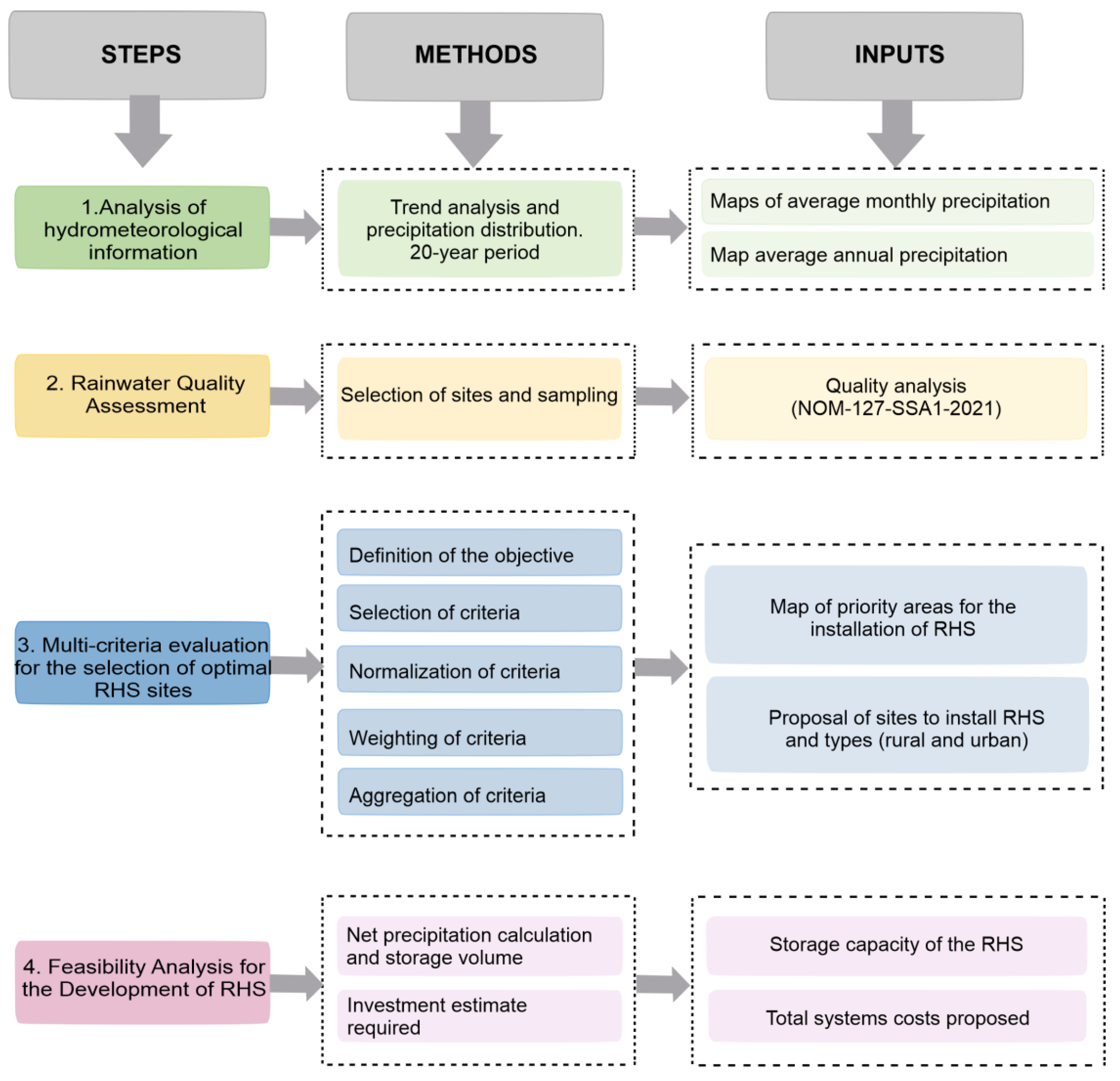
2. Materials and Methods
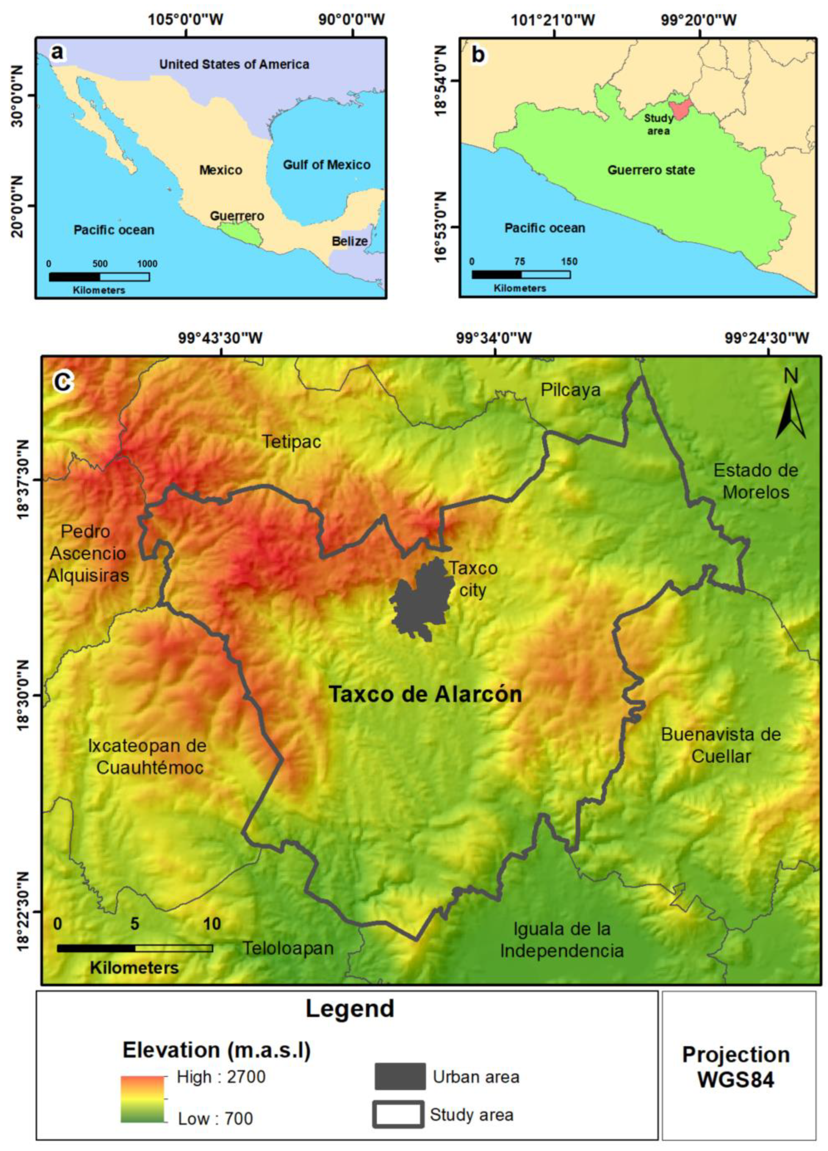
2.1. Study Area

The municipality of Taxco de Alarcón is located in the northern region of the state of Guerrero, Mexico (Figure 1). It measures approximately 651 km2, and its total population is 105,586 inhabitants. In the state of Guerrero, the gross domestic product is USD 3,341. The average annual growth rate of GDP in the last three years is negative, −3%, ranking 22 of 32 states in the country, which has resulted in thousands of people living in poverty [36]. At the municipal level, there is an unemployment rate of 10.5% [39].
The climate in the study area is defined as warm sub-humid (Cw), with a tendency towards sub-humid semi-warm in the mountainous areas. The average annual temperature is 18 °C in the mountains and over 20 °C in the plains. The hottest months are March, April, and May, and the coldest is December. Annual precipitation is approximately 1252 mm [40].
Taxco is recognized as an important tourist center and an international producer of handicrafts and precious metal jewelry, mainly silver [38]. Until 2009 it was known for mining exploitation, which began during pre-Hispanic times and has negatively affected natural resources such as water [37].
Over recent years, access to water for domestic and human use has become limited due to population growth in urban and semi-urban areas, with dug wells, springs, and the San Marcos dam system being unable to meet the population’s demand for water. In addition, the quality of the water resources in this region is not desirable, and the water is not viable for those uses [38,41].

2.2. Compilation of Cartographic, Hydrometeorological, and Socioeconomic Information

This study collected hydrometeorological (precipitation, temperature), cartographic (digital elevation model, land use and vegetation), and socioeconomic (population density, distance to localities) information. The data were downloaded from DAYMET (https://daymet.ornl.gov/ accessed on 3 March 2022) the United States Geological Survey (USGS), and the Mexican National Institute of Statistics, Geography, and Informatics (INEGI, in Spanish). Figure 2 shows the methodology adopted for this research.
The distribution and trends in the variability of precipitation in the municipality of Taxco were analyzed based on data obtained from NASA’s Daymet V4 portal, which is comprised of data from daily weather observations to produce gridded estimates of daily weather parameters. Raster data with a resolution of 1 km were obtained, which were collected monthly for a period of 20 years (2001 to 2021). TerrSet software was used to obtain average monthly precipitation by summing up the monthly precipitation over the 20-year period and calculating the average annual precipitation by analyzing the 12 resulting images.

2.3. Evaluation of Rainwater Quality

A pixel analysis of the average annual precipitation map was used to select sampling sites where the precipitation ranged from 900 mm to 1300 mm. A homogeneous distribution of the sites and easy access was sought (Figure 3). As a result of this project, six rainwater sampling stations were installed, whose characteristics are detailed in Table 1.
A total of 18 rainwater samples were collected during the months of June, August, and October. Using the event accumulation method and a simple conventional collector, the rainwater was taken directly from the sky without it touching any roof surfaces. The sampling was based on procedures established by Mexican guidelines NOM-230-SSA1-2002 [42]. To determine the chemical composition of the rainwater, physicochemical and microbiological parameters were analyzed. Three samples were taken to analyze anions, cations, and fecal coliforms. For the analysis of anions and cations, the samples were filtered through a 0.40–0.45 μm membrane and then transferred to 125-mL polyethylene bottles. In the case of the cation samples, these were acidified with HNO3 at a pH < 2. The fecal coliform samples were collected using sterile polyethylene containers and preserved at 4 °C until analysis in the laboratory. Fecal coliform analyses were performed in the laboratory based on the Most Probable Number (MPN) in multiple tubes, as stated in Mexican guideline NMX-AA-42-SCFI-2015 [43].
The anion and cation samples were analyzed at the Environmental Geochemistry Laboratory of the Geosciences Center at the National Autonomous University of Mexico (UNAM in Spanish), Mexico. Anion samples were analyzed using high-performance liquid chromatography (HPLC) with a Dionex ICS-1100 chromatograph. Cation samples were analyzed using inductively coupled plasma optical emission spectroscopy (ICP-OES) with a PerkinElmer ICAP 6500 Duo.

2.4. Multi-Criteria Evaluation for the Selection of Optimal RHS Sites

The multi-criteria methodology involved five steps: (1) defining the objective, (2) selecting the criteria, (3) standardizing, (4) weighting, and (5) aggregating the criteria. The methodological steps are described below.
1.
Objective:
To identify and select the optimal sites for implementing rainwater harvesting systems in the municipality of Taxco de Alarcón, Guerrero.
2.
Criteria selection:
The factors and constraints that affected the objective of the research were selected and are shown in Table 2.
2.1.
Factor correlation analysis
Pearson’s correlation analysis was conducted to determine the degree to which the selected factors were duplicated. This analysis was performed with TerrSet software using the PCA (principal component analysis) panel with a T-mode analysis, which generated a matrix representing the relationships among the images [47] (Table 3).
3.
Normalization
The factors were normalized to be comparable with each other (common scale bytes 0 to 255). This process used fuzzy logic normalization with the fuzzy module in the TerrSet software and increasing and decreasing sigmoid functions, as adapted to each factor. The increasing sigmoid function was used for precipitation, distance to localities, and population density, and the decreasing function was used for slope and evapotranspiration. The criteria were normalized according to Equation (1) [48]:
Xi = ( R i R m i n ) ( R m a x R m i n ) · S R
where Xi = new value, standardized per pixel; Ri = value of the factor, per pixel; Rmin = minimum value of the factor, per pixel; Rmax = maximum value of the factor, per pixel; and SR = maximum threshold of the range to be standardized (255).
The constraint (land use and vegetation) was converted into a Boolean map (0 and 1), with 0 representing areas where the implementation of RHS was not permitted and 1 representing those where it was permitted.
A value of 1 was given to urban and agricultural areas since RHS are designed to supply the population with water for domestic activities. A value of 0 was assigned to all vegetation areas where no human activities took place because they are difficult to access.
4.
Weighting
Weighting involved assigning a value of importance to one factor with respect to another. This process was performed with the collaboration of a group of experts in hydrology, climate, and geography. After defining the importance of each factor, the group weighted them using the Analytical Hierarchical Process (AHP) technique. This process used the TerrSet WEIGHT module, which performs a pairwise comparison in order to obtain the weights of the factors. The consistency ratio (CR) was also calculated, according to Saaty [49], where the weighting coefficients are acceptable when CR is less than 0.1. Consistency was defined as:
CR = C I R I
where RI = random index, and CI = consistency index. The consistency index is calculated as follows:
CI = λ m a x n n 1
where λmax = ∑λ I, where i = total; λ = weights per factor; and n = number of factors.
5.
Aggregation of criteria
The weighted linear combination (WLC) method, considered to be the most widely-used method for evaluating multiple criteria, was used for the aggregation of the criteria. With this process, each factor was multiplied by the assigned weights, followed by a second multiplication of the prior result with the constraint (Boolean map). This combination was performed according to Equation (4) [50]:
S = i = 1 n W i   X i · C j
where S = suitability; n = number of factors; Wi = weight of factor I; Xi = value of factor i; Cj = criterion score of constraint j; and Π = product of constraints (with j = 1 … n).
The overlapping of the three priority categories (MCE result) with the total population per locality made it possible to identify the most viable locations for the implementation of RHS, as well as the type of RHS that best suited the needs of those areas.

2.5. Feasibility Analysis for the Development of Rainwater Harvesting Systems (RHS)

A feasibility analysis was performed for the installation of two types of RHS: urban (residential) and rural (water pot). The amount of water for domestic use that was required per person was considered for each case. This data was taken from the technical guidelines for the installation of RHS established by Mexico’s National Water Commission (CONAGUA in Spanish) [22]. In addition, the amount of rainwater to be stored by the harvesting system to provide sufficient water to meet the population’s demand was estimated. The following equation was used to calculate net precipitation [47]:
NP = P × Hc × Rc
where NP = net design precipitation; P = precipitation; Hc = harvesting coefficient; and Rc = runoff coefficient.
Precipitation data were obtained from the average annual precipitation map that was generated (Figure 3).
An estimated harvesting coefficient of 0.85 [51] was used, which discounts losses due to factors such as splashing and wind speed. The runoff coefficient value took into account the type of material in the catchment area. The most common coefficients are 0.8 for concrete and metal sheets and 0.9 for PVC geomembranes and roof tiles [22].
The cistern volume required to ensure the supply of rainwater to the population was calculated based on the mass balance. Using this method, a balance of inflows (monthly rainfall) and outflows (monthly demand) was calculated, their accumulated differences were obtained, and the maximum value was taken as the minimum volume that the storage system required. This balance was used for both urban and rural RHS and was defined by the following equation.
Vi = Sci − Dci
whewhere Vi = storage volume for the month (m3); Sci = cumulative supply per month (m3); and Dci = cumulative demand per month (m3).
Subsequently, the investment required for the installation of an urban RHS was estimated, which was divided into total costs (gutter, downspout, leaf filter, and storage structure) and total costs without a storage structure (gutter, downspout, and leaf filter). The components of the system were designed in order to determine the costs of the system. For collection and drainage, PVC material with a 6-inch pipe diameter was proposed for sufficient flow to carry the water during maximum rainfall and in accordance with the measurements of the selected catchment area. The investment required for the installation of a rural RHS was also estimated, where total costs included land leveling, excavation, and placement of geomembranes. The optimal ground measurements, labor costs, and quantity of materials required were quantified based on the results obtained from the mass balance.
Last, the cost per cubic meter of rainwater was obtained to determine the economic feasibility of implementing HRS, which was calculated using the following equation [52]:
( $ m 3 ) = T o t a l   C o s t s ( $ ) V o l u m e   h a r v e s t e d ( m 3 y e a r )

3. Results and Discussion

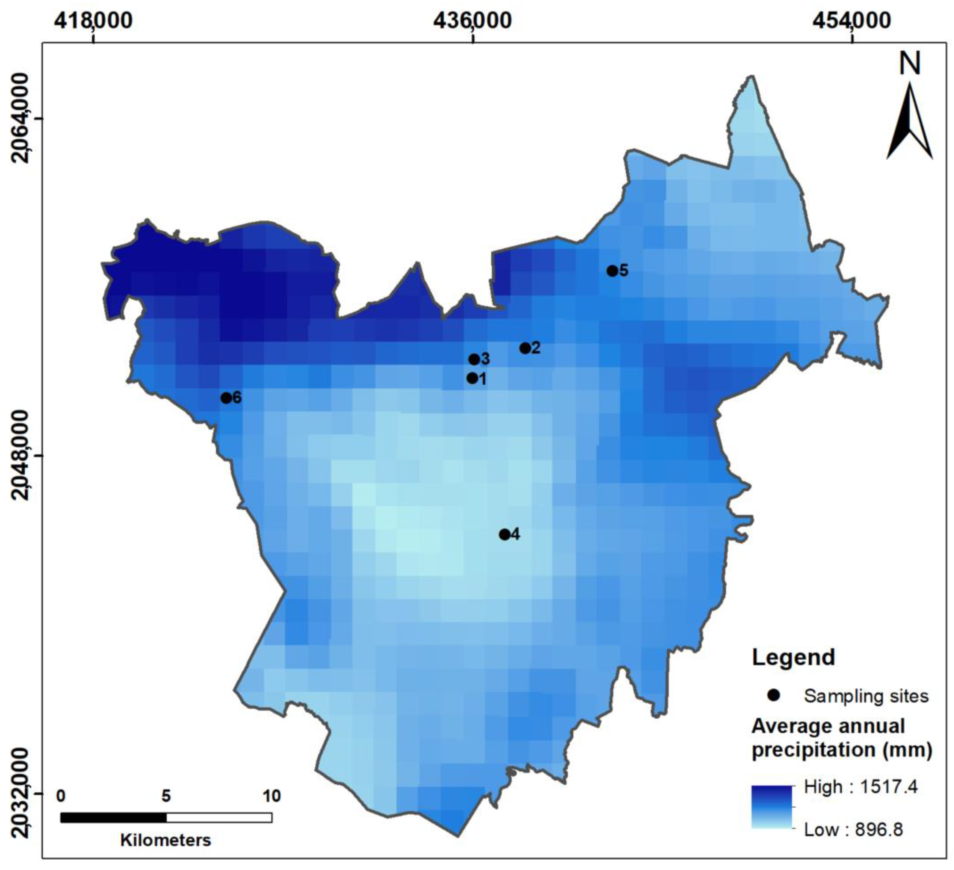
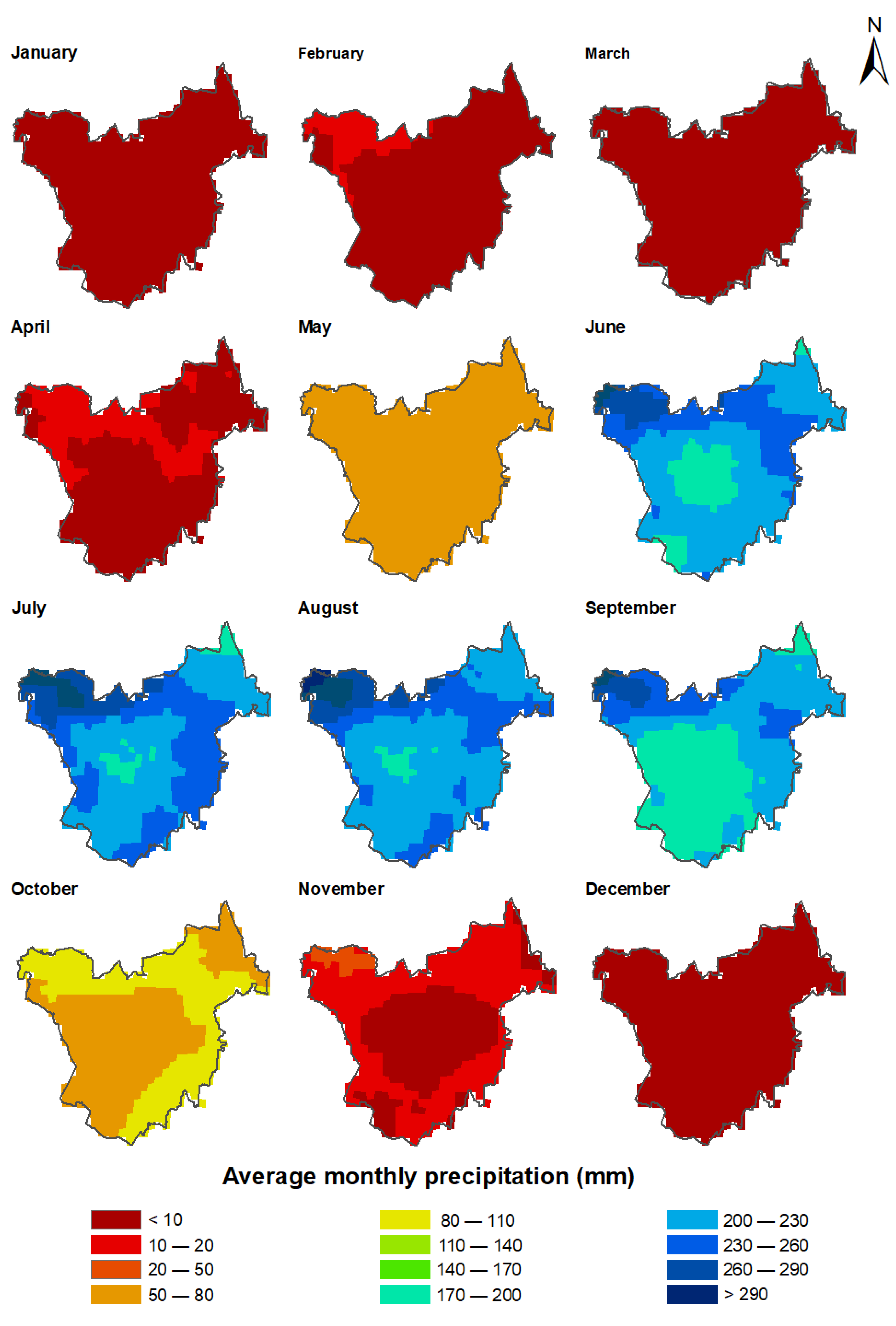
3.1. Analysis of Hydrometeorological Information

Figure 4 shows the results of the rainfall trends from 2001 through 2021. As can be seen, the most intense rainfall occurred during the summer season, with July being the rainiest month, followed by August, June, September, and October. Rainfall ranged from 50 mm to 290 mm or more during these months. Meanwhile, a significant decrease in rainfall was observed in November, with a range of less than 10 mm to 50 mm, a trend that continued until April. Last, May presented an increase in precipitation to between 50 and 80 mm. The northwestern portion of the municipality is at a higher altitude and received the most precipitation (as much as 300 mm in July), while in the center and southern areas of the municipality, precipitation was lower (between 170 and 200 mm in July). This variation in precipitation is attributed to differences in altitude.

3.2. Rainwater Quality Assessment

Rainwater quality was evaluated to identify whether it was feasible to use the water for domestic activities based on the maximum permissible limits stipulated by Mexican guidelines NOM-SSA-127-2021 for human use and consumption [48]. The results show that the rainwater met the criteria for human use and consumption and could therefore be used for domestic activities at nearly all of the sites. Only the Agua Blanca site presented iron that was slightly above the criterion of 0.3 mg/L, which occurred during the last sampling. Supplementary Table S1 shows the data that was obtained (Table S1: Physicochemical parameters (average, minimum, and maximum) measured at the sampling sites, evaluated in accordance with NOM-SSA-127-2021 [53]. pH: the potential of hydrogen in units. Fecal coliform: colony forming units (CFU/100 mL)).

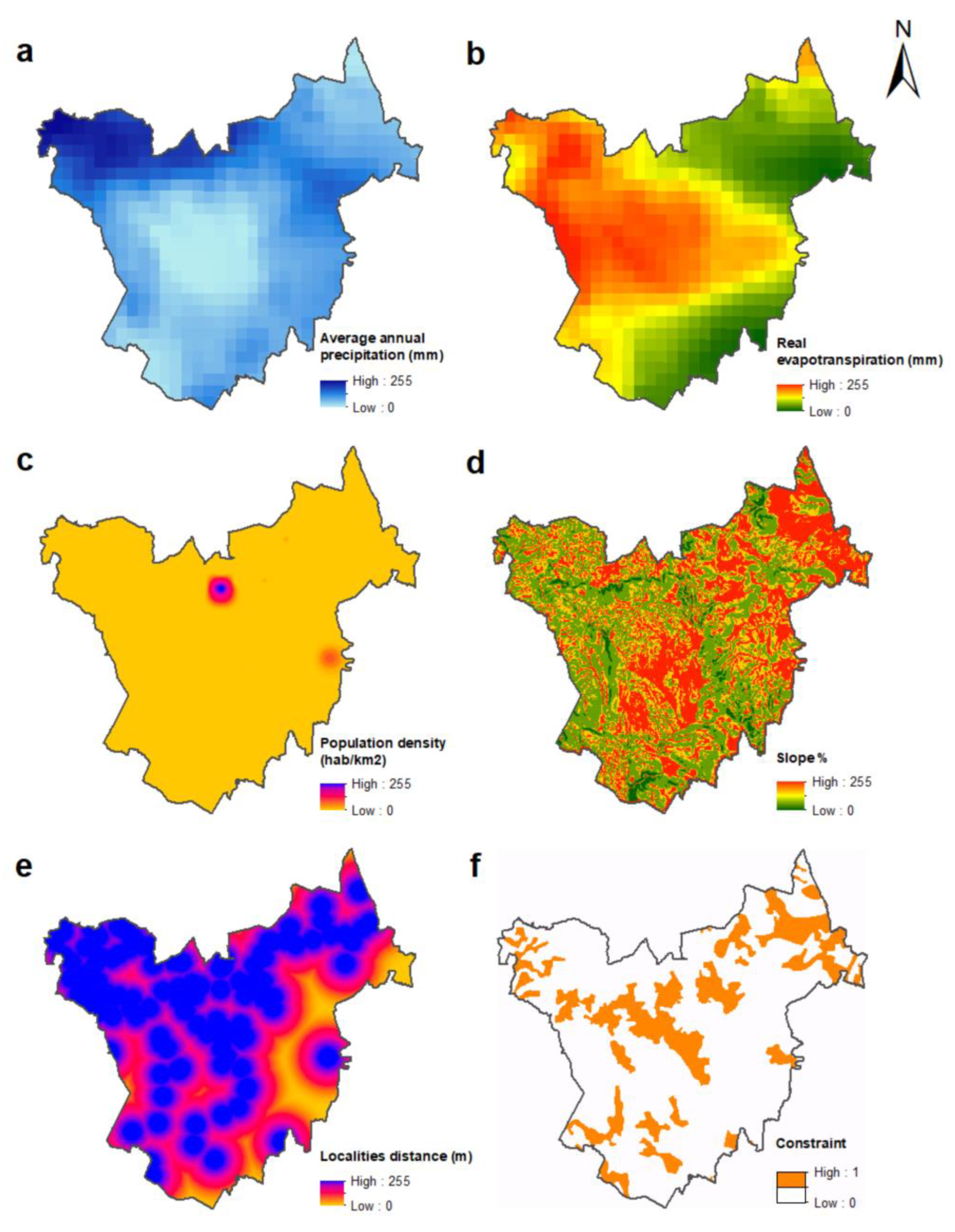
3.3. Multi-Criteria Evaluation for the Selection of Optimal RHS Sites

This study analyzed five factors and one constraint. The factors included were: average annual precipitation, slopes, distance to locations, population density, and annual real evapotranspiration. The constraint was agricultural use/urban and vegetation areas Pearson’s correlation analysis resulted in ranges from high negative to low positive correlations (−0.66 to 0.37) [54], indicating that there was no duplication of the factors analyzed. However, slope and population density presented a very high positive correlation (0.88). This density was due to the fact that the relief of the municipality of Taxco is rugged and the areas with a gentle slope (<15) had higher population density, for example, in the municipal capital and localities such as Taxco el Viejo and Acuitlapán.
The criteria analyzed were normalized on a common scale from not suitable (0) to very suitable (255) for the case of the factors, and the constraint was a Boolean image (0 = RHS implementation not permitted and 1 = RHS implementation permitted) (Figure 5).
After applying the AHP method, the weights of each factor were obtained taking into account the opinions of the group of experts. The results are as follows, in order of importance: 1. precipitation, 2. evapotranspiration, 3. population density, 4. slope, and 5. distance to localities. In addition, this function made it possible to calculate the consistency ratio (CR), which in this case was 0.07, indicating that the weighting was acceptable (Table 4).
A suitability map was generated as a result of the MCE. This map was classified into three priority categories (high, medium, and low) to identify sites that were suitable for implementing an HRS. High-priority areas were notable in the northwestern portion of the municipality of Taxco, which is consistent with the weight obtained from the precipitation factor. Low- and medium-priority areas were located in the municipal capital. In addition, areas with low priority were distributed throughout the northeastern, central, and southern parts of the municipality, most of which were in the southern region. These areas had lower precipitation and higher evapotranspiration (Figure 6).
Five rural localities, each with a population of less than 200 inhabitants, are located in northwestern Taxco where the high category was notable [36]. The installation of a water pot is recommended (a rural-type RHS) in these areas and is considered to be economically viable for the local population. The captured water is recommended for domestic use (washing clothes and bathroom), as well as for agriculture and livestock since the standards for the latter two are less stringent. The locality of Horconcito is proposed as its location (Table 5).
Two RHS are proposed for the medium-priority category, one of which is suggested for the urban area of the municipality of Taxco (municipal capital). While this region does not present water shortage problems, this site was considered due to its high population density, large number of tourists, and high water demand. An urban type of RHS is recommended for this region, where the water that is harvested can be used for domestic use (watering gardens, cleaning, washing clothes, and personal hygiene). The Pilita neighborhood is proposed for its installation. The second site that is suggested is in northwestern Taxco, at the elementary and secondary schools in the town of Santo Domingo (Table 5). The water that is collected is recommended for bathroom use.
For the low category, which is notable in the northeastern, central, and southern areas of the municipality, four RHS sites are suggested to mitigate both the present and future effects of water scarcity. This suggestion is supported by the Secretary of the Environment (SEDEMA in Spanish) (2020), which indicates a minimum of 400 mm annual precipitation for installing an RHS, whereas the minimum precipitation in the municipality of Taxco is 896 mm (Figure 3). Currently, the localities of Tlamacazapala and Acuitlapán present water shortage problems and have a high population density, with the second and fourth largest number of inhabitants in the municipality, respectively [36]. The installation of urban-type RHS is proposed for Tlamacazapa, Acuitlapán, Taxco el Viejo, and Huahuaxtla (Table 5). It is recommended that they be installed in the educational facilities in these localities and the water used for bathroom purposes. Figure 7 shows the sites proposed for the installation of the RHS.

3.4. Feasibility Analysis for the Development of Rainwater Harvesting Systems (RHS)

The feasibility analysis for installing urban and rural RHS included two of the seven proposed sites, based on a minimum consumption per person of 100 L for case urban and 50 L for case rural [22].
The rural RHS was calculated for 308 inhabitants with a net precipitation of 1234 mm. The urban RHS was calculated for an average 5-person single-family household in the municipal capital, the site where the sampling was conducted, and where net precipitation was 731.34 mm. Two conditions were considered to obtain the storage capacity: supplying the storage tank with water throughout the entire year and supplying water only during the rainy season. Table 6 presents the results of the two rainwater harvesting systems.
The total cost to install both types of RHS was estimated. This study did not consider the cost of energy for pumping the captured rainwater since, in this case, both the urban and rural RHS designs that are proposed do not require electricity, but rather, water is extracted by gravity or manual pumping.
Given that total costs are primarily affected by the cost of the storage structure, which requires a larger financial investment, the cost of each type of RHS was calculated for two storage capacity conditions: annual and the rainy season. In the case of the rural RHS, a total cost of USD 11,945 was obtained for the annual supply and USD 10,576 for the rainy season supply, with a cost per m3 of water captured of USD 4.8 and USD 4.7 dollars, respectively (Table 7). The total cost for the urban RHS was USD 2146.6 for the annual supply and USD 1176.6 for the rainy season supply, with USD 16.3 and USD 9.8 dollars per m3 of water captured, respectively. Total costs were also estimated without a storage structure since it is possible to use some type of storage that already exists in the homes where it is desirable to install the systems. In this case, the cost obtained was USD 206.6, with USD 1.6 per m3 of water captured for the annual supply and USD 1.7 for the rainy season supply. As can be seen, the costs per m3 of water captured for the urban systems are considerably lower when the cost of the storage structure is not included (Table 7).
The collection of water only during the rainy season is recommended when the annual system cannot be built for financial reasons. Since the initial investment is high due to the cost of the storage system, many cases result in an RHS not being feasible. However, this cost is compensated by the low cost per cubic meter of water for both systems. In Taxco de Alarcón, the annual cost per cubic meter of water for an average family of five is roughly USD 17 (based on municipal water fees). Since this cost is higher than the per cubic meter of captured water (Table 7), the initial investment of the RHS is justified. In addition, as shown, the installation of an urban RHS is more economically viable when using existing storage structures. It is crucial to invest in rainwater collection systems because they not only generate an economic return but also have environmental advantages. Namely, water is not extracted from a supply source (municipal networks) or from the subsoil, so RHS do not affect the environment. Thus, the use of RHS promotes more sustainable methods for managing water resources.
In many cases, the initial investment in an RHS is high. Therefore, it is imperative to know the different financial assistance programs that are available for implementing these systems at both the municipal and national levels. Some of the most relevant programs in Mexico that provide this kind of aid follow:
  • National Rainwater Harvesting Program and Ecotechnologies in Rural Areas (PROCAPTAR in Spanish) and National Water Commission (CONAGUA in Spanish) [55].
  • Financing for tourism projects that use sustainable technologies such as rainwater harvesting. National Tourism Development Fund (FONATUR in Spanish) [56].
  • Economic support for the use of sustainable technologies in rural housing, including rainwater harvesting systems. Ministry of Rural, Urban, and Land Development (SEDATU in Spanish) [57].
It is important to review each program’s requirements and calls for proposals to know which one is most suitable for a project.

4. Conclusions

The findings of the present study highlight a potential solution to managing water scarcity problems by improving water supply in the near future. The main conclusions derived from this research include the following:
Rainwater quality in the study area was found to be optimal for domestic activities. The anthropogenic influence is minimal, a finding that is contrary to what has been discussed by other studies [58] and in other parts of Mexico [59]. The presence of Fe in rainwater in Agua Blanca during the month of October could be related to the lithology of the site due to the erosion of the volcanic rocks in the Tilzapotla formation.
This multi-criteria evaluation analyzed and normalized five factors and one constraint. The factors included average annual precipitation, slopes, distance to localities, population density, and annual real evapotranspiration. The constraint was agricultural use/urban and vegetation areas. To weight the factors, the AHP method was applied in a GIS environment, followed by the aggregation of criteria using the weighted linear combination (WLC) method, which assumes medium risk for decision-making. The result was a prioritization map for the installation of RHS, which was classified according to three categories: high, medium, and low. This map was superimposed on the total population per locality at the municipal level, resulting in the selection of seven rural and urban sites that are viable for implementing RHS to enable optimizing the hydrometeorological and socioeconomic resources. Therefore, this study demonstrates that multi-criteria analysis is a useful tool, as has been indicated by innumerable studies involving rainwater harvesting.
Rainwater harvesting in the municipality only during the rainiest season (June-October) is advisable when it is not possible to build a rainwater harvesting system for annual storage due to financial reasons since the initial investment is high. The installation of an urban RHS is more economically viable when existing storage structures can be used since investment costs are reduced by not acquiring new structures, which are usually expensive. Furthermore, the initial investment in the implementation of urban and rural RHS is compensated by the low costs per m3 of water captured. These types of studies have been implemented in various parts of the world using different approaches [35,60,61]. Installing RHS is a practical, economical, and efficient alternative that can be implemented on a small scale to manage water resources in order to achieve sustainability for the population.
Despite the efforts that Mexico has already made to promote the implementation of rainwater harvesting systems, these alternatives must continue to be promoted in all areas and sectors. Rainwater harvesting represents a social challenge in terms of the revaluation of rainwater. Society needs to change its perception of the use of rainwater, and users must self-manage this water resource. Therefore, existing government programs should be ongoing and more inclusive.
Last, the methodology used can be replicated in other regions, where favorable results can be obtained depending on the available information.

Supplementary Materials

The following supporting information can be downloaded at: https://www.mdpi.com/article/10.3390/su15108220/s1, Figure S1: World Bank urban population graph for Mexico. Figure S2: Drought Monitor in Mexico, 2022; Table S1: Physicochemical parameters (average, minimum and maximum) measured at the sampling sites, evaluated in accordance with NOM-SSA-127-2021 [53]. pH: the potential of hydrogen in units. Fecal coliform: colony forming units (CFU/100 mL)).

Author Contributions

B.I.R.V.—sampling collection, data analysis, paper writing, and editing; E.R.S.S.—sampling collection, data analysis, paper writing, and editing; J.M.E.M.—sampling collection, map editing, paper writing, and editing; M.Á.G.A.—data analysis, review, and editing; F.G.N.—review and editing; C.G.F. —review and editing; O.T.M.—laboratory analysis and review and editing. All authors have read and agreed to the published version of the manuscript.

Funding

This research received no external funding.

Institutional Review Board Statement

Not applicable.

Informed Consent Statement

Not applicable.

Data Availability Statement

Not applicable.

Acknowledgments

We thank the support of Environmental Geochemistry Laboratory of the National Autonomous University of Mexico for the support of the rainwater analysis.

Conflicts of Interest

The authors declare no conflict of interest.

References

  1. Semaan, M.; Day, S.D.; Garvin, M.; Ramakrishnan, N.; Pearce, A. Optimal Sizing of Rainwater Harvesting Systems for Domestic Water Usages: A Systematic Literature Review. Resour. Conserv. Recycl. X 2020, 6, 100033. [Google Scholar] [CrossRef]
  2. He, C.; Liu, Z.; Wu, J.; Pan, X.; Fang, Z.; Li, J.; Bryan, B.A. Future Global Urban Water Scarcity and Potential Solutions. Nat. Commun. 2021, 12, 4667. [Google Scholar] [CrossRef]
  3. Yannopoulos, S.; Giannopoulou, I.; Kaiafa-Saropoulou, M. Investigation of the Current Situation and Prospects for the Development of Rainwater Harvesting as a Tool to Confront Water Scarcity Worldwide. Water 2019, 11, 2168. [Google Scholar] [CrossRef]
  4. Garrick, D.; De Stefano, L.; Yu, W.; Jorgensen, I.; O’Donnell, E.; Turley, L.; Aguilar-Barajas, I.; Dai, X.; de Souza Leão, R.; Punjabi, B. Rural water for thirsty cities: A systematic review of water reallocation from rural to urban regions. Environ. Res. Lett. 2019, 14, 043003. [Google Scholar] [CrossRef]
  5. WRI (World Resources Institute). Available online: https://www.wri.org/insights/17-countries-home-one-quarter-worlds-population-face-extremely-high-water-stress (accessed on 8 August 2022).
  6. World Bank. Urban Population (% of Total Population)—Mexico. 2022. Available online: https://data.worldbank.org/indicator/SP.URB.TOTL.IN.ZS?locations=MX (accessed on 27 April 2022).
  7. Panagoulia, D.; Dimou, G. Definitions and effects of droughts. In Proceedings of the Conference on Mediterranean Water Policy: Building on Existing Experience, Mediterranean Water Network, Valencia, Spain, 16–18 April 1998; Volume I. p. 11. [Google Scholar]
  8. Panagoulia, D. Sensitivity analysis of catchment hydrologic response to climate changes in NATO—Advanced Research Workshop. In Diachronic Climatic Impacts on Water Resources with Emphasis on Mediterranean Region; Springer: Berlin/Heidelberg, Germany, 1993; pp. 23–24. [Google Scholar]
  9. Arreguin-Cortes, F.I.; Saavedra-Horita, J.R.; Rodriguez-Varela, J.M.; Tzatchkov, V.G.; Cortez-Mejia, P.E.; Llaguno-Guilberto, O.J.; Sainos-Candelario, A. State Level Water Security Indices in Mexico. Sustain. Earth 2020, 3, 9. [Google Scholar] [CrossRef]
  10. CONAGUA (Comisión Nacional del Agua). Available online: https://smn.conagua.gob.mx/tools/DATA/Climatolog%C3%ADa/Sequ%C3%ADa/Monitor%20de%20sequ%C3%ADa%20en%20M%C3%A9xico/Seguimiento%20de%20Sequ%C3%ADa/MSM20221231.pdf (accessed on 28 April 2023).
  11. Matomela, N.; Li, T.; Ikhumhen, H.O. Siting of Rainwater Harvesting Potential Sites in Arid or Semi-Arid Watersheds Using GIS-Based Techniques. Environ. Process. 2020, 7, 631–652. [Google Scholar] [CrossRef]
  12. Musayev, S.; Burgess, E.; Mellor, J. A Global Performance Assessment of Rainwater Harvesting under Climate Change. Resour. Conserv. Recycl. 2018, 132, 62–70. [Google Scholar] [CrossRef]
  13. Zang, J.; Kumar, M.; Werner, D. Real-World Sustainability Analysis of an Innovative Decentralized Water System with Rainwater Harvesting and Wastewater Reclamation. J. Environ. Manag. 2021, 280, 111639. [Google Scholar] [CrossRef]
  14. Barbosa de Jesus, T.; Costa Kiperstok, A.; Borges Cohim, E. Life Cycle Assessment of Rainwater Harvesting Systems for Brazilian Semi-arid Households. Water Environ. J. 2020, 34, 322–330. [Google Scholar] [CrossRef]
  15. Sayl, K.; Adham, A.; Ritsema, C.J. A GIS-Based Multicriteria Analysis in Modeling Optimum Sites for Rainwater Harvesting. Hydrology 2020, 7, 51. [Google Scholar] [CrossRef]
  16. Freni, G.; Liuzzo, L. Effectiveness of Rainwater Harvesting Systems for Flood Reduction in Residential Urban Areas. Water 2019, 11, 1389. [Google Scholar] [CrossRef]
  17. Abdulla, F. Rainwater Harvesting in Jordan: Potential Water Saving, Optimal Tank Sizing and Economic Analysis. Urban Water J. 2020, 17, 446–456. [Google Scholar] [CrossRef]
  18. Zabidi, H.A.; Goh, H.W.; Chang, C.K.; Chan, N.W.; Zakaria, N.A. A Review of Roof and Pond Rainwater Harvesting Systems for Water Security: The Design, Performance and Way Forward. Water 2020, 12, 3163. [Google Scholar] [CrossRef]
  19. Lee, K.E.; Mokhtar, M.; Mohd Hanafiah, M.; Abdul Halim, A.; Badusah, J. Rainwater harvesting as an alternative water resource in Malaysia: Potential, policies and development. J. Clean. Prod. 2016, 126, 218–222. [Google Scholar] [CrossRef]
  20. Khanal, G.; Thapa, A.; Devkota, N.; Paudel, U.R. A Review on Harvesting and Harnessing Rainwater: An Alternative Strategy to Cope with Drinking Water Scarcity. Water Sci. Technol. Water Supply 2020, 20, 2951–2963. [Google Scholar] [CrossRef]
  21. Rajasekhar, M.; Gadhiraju, S.R.; Kadam, A.; Bhagat, V. Identification of Groundwater Recharge-Based Potential Rainwater Harvesting Sites for Sustainable Development of a Semiarid Region of Southern India Using Geospatial, AHP, and SCS-CN Approach. Arab. J. Geosci. 2020, 13, 24. [Google Scholar] [CrossRef]
  22. CONAGUA (Comisión Nacional del Agua). Lineamientos Técnicos: Sistema de Captación de Agua de Lluvia Con Fines de Abasto de Agua Potable a Nivel Vivienda. Gobierno de México. 2016. Available online: https://www.gob.mx/cms/uploads/attachment/file/152776/LINEAMIENTOS_CAPTACI_N_PLUVIAL.pdf (accessed on 3 August 2022).
  23. SEDEMA (Secretaría del Medio Ambiente de la Ciudad de México). Manual Para Instalar un Sistema de Captación Pluvial en tu Vivienda. Gobierno de México. 2020. Available online: https://www.sedema.cdmx.gob.mx/storage/app/media/DGCPCA/ManualCosecharLaLluvia.pdf (accessed on 25 April 2023).
  24. Kucukkaya, E.; Kelesoglu, A.; Gunaydin, H.; Kilic, G.A.; Unver, U. Design of a Passive Rainwater Harvesting System with Green Building Approach. Int. J. Sustain. Energy 2021, 40, 175–187. [Google Scholar] [CrossRef]
  25. Ammar, A.; Riksen, M.; Ouessar, M.; Ritsema, C. Identification of suitable sites for rainwater harvesting structures in arid and semi-arid regions: A review. Int. Soil Water Conserv. Res. 2016, 4, 108–120. [Google Scholar] [CrossRef]
  26. Shadeed, S.M.; Judeh, T.G.; Almasri, M.N. Developing GIS-Based Water Poverty and Rainwater Harvesting Suitability Maps for Domestic Use in the Dead Sea Region (West Bank, Palestine). Hydrol. Earth Syst. Sci. 2019, 23, 1581–1592. [Google Scholar] [CrossRef]
  27. Mbilinyi, B.P.; Tumbo, S.D.; Mahoo, H.F.; Mkiramwinyi, F.O. GIS-Based Decision Support System for Identifying Potential Sites for Rainwater Harvesting. Phys. Chem. Earth 2007, 32, 1074–1081. [Google Scholar] [CrossRef]
  28. Weerasinghe, H.; Schneider, U.A.; Löw, A. Water Harvest- and Storage- Location Assessment Model Using GIS and Remote Sensing. Hydrol. Earth Syst. Sci. Discuss. 2011, 8, 3353–3381. [Google Scholar] [CrossRef]
  29. Shalamzari, M.; Gholami, A.; Khalighi, S.; Alizadeh, A.; Arzani, H. Site selection for rainwater harvesting for wildlife using multi-criteria evaluation (MCE) technique and GIS in the Kavir National Park, Iran. J. Rangel. Sci. 2018, 8, 77–92. [Google Scholar]
  30. Mugo, G.M.; Odera, P.A. Site Selection for Rainwater Harvesting Structures in Kiambu County-Kenya. Egypt. J. Remote Sens. Space Sci. 2019, 22, 155–164. [Google Scholar] [CrossRef]
  31. Krois, J.; Schulte, A. GIS-based multi-criteria evaluation to identify potential sites for soil and water conservation techniques in the Ronquillo watershed, northern Peru. Appl. Geogr. 2014, 51, 131–142. [Google Scholar] [CrossRef]
  32. Mahmood, K.; Qaiser, A.; Farooq, S.; Nisa, M. un RS- and GIS-Based Modeling for Optimum Site Selection in Rain Water Harvesting System: An SCS-CN Approach. Acta Geophys. 2020, 68, 1175–1185. [Google Scholar] [CrossRef]
  33. Farooq, S.; Mahmood, K.; Faizi, F. Comparative Simulation of GIS-Based Rainwater Management Solutions. Water Resour. Manag. 2022, 36, 3049–3065. [Google Scholar] [CrossRef]
  34. Van Dijk, S.; Lounsbury, A.W.; Hoekstra, A.Y.; Wang, R. Strategic Design and Finance of Rainwater Harvesting to Cost-Effectively Meet Large-Scale Urban Water Infrastructure Needs. Water Res. 2020, 184, 116063. [Google Scholar] [CrossRef]
  35. Musz-Pomorska, A.; Widomski, M.K.; Gołębiowska, J. Financial Sustainability of Selected Rain Water Harvesting Systems for Single-Family House under Conditions of Eastern Poland. Sustainability 2020, 12, 4853. [Google Scholar] [CrossRef]
  36. INEGI (Instituto Nacional de Estadística y Geografía). Available online: https://www.inegi.org.mx/contenidos/productos/prod_serv/contenidos/espanol/bvinegi/productos/nueva_estruc/702825197858.pdf (accessed on 10 January 2022).
  37. Talavera Mendoza, O.; Ruiz, J.; Díaz Villaseñor, E.; Ramírez Guzmán, A.; Cortés, A.; Salgado Souto, S.A.; Dótor Almazán, A.; Rivera Bustos, R. Water-Rock-Tailings Interactions and Sources of Sulfur and Metals in the Subtropical Mining Region of Taxco, Guerrero (Southern Mexico): A Multi-Isotopic Approach. Appl. Geochem. 2016, 66, 73–81. [Google Scholar] [CrossRef]
  38. Salcedo Sánchez, E.R.; Martínez, J.M.E.; Morales, M.M.; Talavera Mendoza, O.; Alberich, M.V.E. Ecological and Health Risk Assessment of Potential Toxic Elements from a Mining Area (Water and Sediments): The San Juan-Taxco River System, Guerrero, Mexico. Water 2022, 14, 518. [Google Scholar] [CrossRef]
  39. Ayuntamiento de Taxco de Alarcón. Plan Municipal de Desarrollo 2021–2024. Available online: https://congresogro.gob.mx/63/ayuntamientos/plan-municipal/plan-municipal-taxco-de-alarcon.pdf (accessed on 29 April 2023).
  40. INEGI (Instituto Nacional de Estadística y Geografía). Available online: https://www.inegi.org.mx/app/biblioteca/ficha.html?upc=702825192242#:~:text=El%20Instituto%20Nacional%20de%20Estad%C3%ADstica,federativa%2C%20de%20utilidad%20para%20el (accessed on 15 January 2022).
  41. Dótor, A.A.; Armienta, M.A.; Arcega, F.; Talavera, M.O. Transport processes of arsenic and metals in surface waters in the mining district of Taxco, Mexico. Hidrobiológica 2014, 24, 256. [Google Scholar]
  42. DOF (Diario Oficial de la Federación). Norma Oficial Mexicana NOM-230-SSA1-2002, Salud Ambiental. Agua Para uso y Consumo Humano, Requisitos Sanitarios Que se Deben Cumplir en los Sistemas de Abastecimiento Públicos y Privados Durante el Manejo del Agua. Available online: https://dof.gob.mx/nota_detalle.php?codigo=2081772&fecha=12/07/2005#gsc.tab=0 (accessed on 2 June 2022).
  43. Norma Mexicana NMX-AA-042-SCFI-2015, Análisis de agua—Enumeración de Organismos Coliformes Totales, Organismos Coliformes Fecales (Termotolerantes) Y Escherichia coli—Método del Número Más Probable en Tubos Múltiples. Available online: https://www.gob.mx/cms/uploads/attachment/file/166147/nmx-aa-042-scfi-2015.pdf (accessed on 5 June 2022).
  44. DAYMET. Daily Surface Weather and Climatological Summaries. Available online: https://daymet.ornl.gov/ (accessed on 10 February 2022).
  45. USGS (United States Geological Survey). Available online: https://www.usgs.gov/ (accessed on 20 February 2022).
  46. INEGI (Instituto Nacional de Estadística y Geografía). Available online: https://www.inegi.org.mx/ (accessed on 12 February 2022).
  47. Eastman, J. Guide to GIS and Image Processing; Clark University: Whistler, BC, Canada, 2011; Volume 2, p. 33. [Google Scholar]
  48. Eastman, J. IDRISI TerrSet. Geospatial Monitoring and Modeling System; Clark University: Whistler, BC, Canada, 2016; p. 83. [Google Scholar]
  49. Saaty, T.L. How to Make a Decision: The Analytic Hierarchy Process. Eur. J. Oper. Res. 1990, 48, 9–26. [Google Scholar] [CrossRef]
  50. Marinoni, O. Implementation of the analytical hierarchy process with VBA in ArcGIS. Comput. Geosci. 2004, 30, 637–646. [Google Scholar] [CrossRef]
  51. Anaya, M.; Aurora Pérez Hernández, G.M.C.; Nuria, M.C.; López Hernández, A.; Inés, M.C.; Ponce, R.M. Manual Técnico: Sistemas de Captación de Agua de Lluvia (SCALL); Colegio de Postgraduados: Montecillo, Mexico, 2018; Available online: https://funcagua.org.gt/wp-content/uploads/2020/09/2018.-Manual-T%C3%A9cnico-Sistemas-de-captaci%C3%B3n-de-agua-de-lluvia.pdf (accessed on 4 July 2022).
  52. López Hernández, N.A.; Palacios-Vélez, O.L.; Anaya-Garduño, M.; Chávez-Morales, J.; Rubiños-Panta, J.E.; García-Carrillo, M. Diseño de sistemas de captación del agua de lluvia: Alternativa de abastecimiento hídrico. Rev. Mex. Cienc. Agric. 2017, 8, 1433–1439. [Google Scholar] [CrossRef]
  53. DOF (Diario Oficial de la Federación). Norma Oficial Mexicana NOM-127-SSA1-2021, Agua para uso y Consumo Humano. Límites Permisibles de la Calidad del Agua. Available online: https://www.dof.gob.mx/nota_detalle.php?codigo=5650705&fecha=02/05/2022#gsc.tab=0 (accessed on 2 November 2022).
  54. Moriasi, D.N.; Gitau, M.W.; Pai, N.; Daggupati, P. Hydrologic and water quality models: Performance measures and evaluation criteria. Trans. ASABE 2015, 58, 1763–1785. [Google Scholar] [CrossRef]
  55. CONAGUA (Comisión Nacional del Agua). Programa Nacional para Captación de Agua de Lluvia y Ecotecnias en Zonas Rurales (PROCAPTAR). Gobierno de México. 2017. Available online: https://www.gob.mx/conagua/acciones-y-programas/programa-nacional-para-captacion-de-agua-de-lluvia-y-ecotecnias-en-zonas-rurales-procaptar (accessed on 29 April 2022).
  56. FONATUR (Fondo Nacional de Fomento al Turismo). Gobierno de México. Available online: https://www.gob.mx/fonatur (accessed on 29 April 2022).
  57. SEDATU (Secretaría de Desarrollo Agrario, Territorial y Urbano). Gobierno de México. Available online: https://www.gob.mx/sedatu (accessed on 29 April 2022).
  58. Velázquez Ocampo, J.E. Detección de Metales y Metaloides en Agua de Lluvia en el Distrito Minero de Taxco, Guerrero. Master’s thesis, Universidad Nacional Autónoma de México, Mexico City, Mexico, November 2018. [Google Scholar]
  59. Gispert, M.; Hernández, M.; Climent, E.; Flores, M. Rainwater Harvesting as a Drinking Water Option for Mexico City. Sustainability 2018, 10, 3890. [Google Scholar] [CrossRef]
  60. Zhou, W.; Matsumoto, K.; Sawaki, M. Understanding the Traditional Wisdom of Harvesting Rainwater in Household Yards: Construction and Rainwater Usage Patterns of Settlement Water Cellars in Semi-Arid China. J. Asian Arch. Build. Eng. 2023, 22, 589–601. [Google Scholar] [CrossRef]
  61. Alene, A.; Yibeltal, M.; Abera, A.; Andualem, T.G.; Lee, S.S. Identifying Rainwater Harvesting Sites Using Integrated GIS and a Multi-Criteria Evaluation Approach in Semi-Arid Areas of Ethiopia. Appl. Water Sci. 2022, 12, 238. [Google Scholar] [CrossRef]
Figure 1. Location map. (a) Mexico, (b) the state of Guerrero, and (c) the study area.
Sustainability 15 08220 g001
Figure 2. Methodological strategy.
Sustainability 15 08220 g002
Figure 3. Average annual precipitation for the period 2001 to 2021 and sampling sites in the municipality of Taxco de Alarcón, Guerrero.
Sustainability 15 08220 g003
Figure 4. Monthly rainfall distribution and trends.
Sustainability 15 08220 g004
Figure 5. Normalized factors and constraint: (a) average annual precipitation, (b) real evapotranspiration, (c) population density, (d) slope, (e) distance to localities, and (f) constraint.
Sustainability 15 08220 g005
Figure 6. Priority areas for the installation of RHS.
Sustainability 15 08220 g006
Figure 7. Suitable sites for the installation of a rural and urban RHS.
Sustainability 15 08220 g007
Table 1. Rainwater sampling stations.
Rainwater Sampling Stations
Station idLocalityxyz (m.a.s.l)Installation date
1Pilita435,991.32,051,682.817612 June 2022
2Casallas438,5042,053,110.816703 June 2022
3Agua Blanca436,093.72,052,571.318692 June 2022
4Taxco el Viejo437,541.12,044,278.314613 June 2022
5Acuitlapán442,667.22,056,779.415323 June 2022
6Horconcito424,323.52,050,737.123763 June 2022
Table 2. Criteria and data sources for the multi-criteria evaluation.
FactorsSource
Precipitation:
period 2001 to 2021
Determined using monthly precipitation data obtained from Daymet [44].
SlopeDetermined with the digital elevation model obtained from the United States Geological Survey [45].
Distance to localities Determined using vector information obtained from the INEGI site [46].
Population densityDetermined from vector information obtained from the INEGI site [46].
Real evapotranspiration:
period 2001 to 2021
Determined based on monthly precipitation data and maximum and minimum temperatures obtained from Daymet [44].
ConstraintSource
Land use and vegetationObtained from INEGI site [46].
Table 3. Correlation matrix for the factors considered.
Correlation MatrixReal EvapotranspirationPopulation DensityDistance to Localities SlopePrecipitation
Real evapotranspiration1−0.180.37−0.190.01
Population density−0.181−0.660.88−0.09
Distance to localities 0.37−0.661−0.58−0.08
Slope−0.190.88−0.581−0.05
Precipitation0.01−0.09−0.08−0.051
Table 4. Pairwise comparison matrix.
FactorPopulation
Density
Distance to
Localities
Real EvapotranspirationSlopePrecipitationWeights
Population density1 0.1149
Distance to localities 1/51 0.0321
Real evapotranspiration371 0.2655
Slope1/331/71 0.0574
Precipitation793710.5300
Table 5. Sites proposed for RHS installation.
Sites Proposed for RHS Installation
IdLocalityxyz (m.a.s.l)
1Pilita435,991.32,051,682.81761
2Taxco el Viejo438,705.12,042,909.71221
3Acuitlapán443,050.82,056,778.71573
4Horconcito423,441.82,053,396.72376
5Santo Domingo420,971.52,052,984.82093
6Tlamacazapa446,861.12,045,361.41986
7Huahuaxtla433,789.92,036,210.91254
Table 6. Results of the design of the two RHS.
RHSPopulationNet Precipitation (mm)Annual Water Demand (m3)Catchment Area (m2)Storage Capacity
Annual (m3)Rainy Season (June–October) (m3)
Rural30812345621300018060
Urban5731.34182.51804010
Table 7. Costs of the RHS.
Rural RHSUrban RHS
Costs Annual Supply SystemRainy Season
Supply System
Annual Supply SystemRainy Season Supply System
Captured volume (m3/year)2469 m32234 m3131.5 m3119 m3
Storage volume (m3/year)180 m360 m340 m310 m3
Cost of gutters and downspouts (USD)not applicablenot applicableUSD 206.6USD 206.6
Total Cost (USD)USD 11,945USD 10,576USD 2146.6USD 1176.6
Cost (UDD/m3)USD 4.8USD 4.7USD 16.3USD 9.8
Cost annual without storage (USD/m3)not applicablenot applicableUSD 1.6USD 1.7
Disclaimer/Publisher’s Note: The statements, opinions and data contained in all publications are solely those of the individual author(s) and contributor(s) and not of MDPI and/or the editor(s). MDPI and/or the editor(s) disclaim responsibility for any injury to people or property resulting from any ideas, methods, instructions or products referred to in the content.

