Article

‘Sustainable’ Recording and Preservation of Zangniang Stupa and Sangzhou Lamasery in Qinghai, China with Heritage Building Information Model

1
Department of Architecture, School of Architecture, Tianjin University (TJU), Tianjing 300072, China
2
Department of Landscape Architecture, School of Architecture, Tianjin University (TJU), Tianjing 300072, China
*
Authors to whom correspondence should be addressed.
Sustainability 2022, 14(8), 4549; https://doi.org/10.3390/su14084549
Submission received: 28 January 2022 / Revised: 25 March 2022 / Accepted: 9 April 2022 / Published: 11 April 2022
(This article belongs to the Topic Virtual Reality, Digital Twins, the Metaverse)

Abstract

:
This paper research and discusses the ‘sustainable’ workflow and heritage recording method of historic building information modelling (HBIM) for Chinese Tibetan architecture and pagodas and explains the vital role of recording heritage information to protect cultural relics. Considering the Tibetan Buddhist Pagoda in Yushu, Qinghai, China, this paper explores the collaborative modelling mechanism and ideas between heritage surveying and scanning information and software, and the problems of these two methods. Through research, we have obtained successful cases of HBIM based on field scanning and mapping, online software collaborative modelling (Rhino, Bentley, Autodesk Computer-Aided Design), sustainable management, and display. It is an information model constructed according to construction logic and accurate information and one that realises sustainable and full-cycle recording functions by continuous recording, updating, and iterating. This method removes a limitation of HBIM in that it considers one-time information construction and delivery mode but does not consider and explore sustainable recording work. It will significantly promote more records on the heritage information of Tibetan architecture. The results will also directly serve the protection of architectural heritage in Qinghai Province, China and the ‘Silk Road (South Asia Section) Transnational Serial Application for World Heritage’ work.

1. Introduction

In 2009, Professor Murphy of the University of Dublin in Ireland, who has a background in heritage protection, first proposed using building information modelling (BIM) technology for heritage protection, coining the term historic building information modelling (HBIM) [1], which he defined as a system of cross-platform programmes for mapping parametric objects onto a point cloud and image survey data [2].
Murphy’s doctoral thesis, written in 2012, elaborated on the application and process of HBIM, which he divided into the following five parts: 3D laser scanning, point cloud data processing, parametric logic design, parametric modelling, and HBIM model evaluation and testing [3]. HBIM technology is a new method for sustainably recording the life-cycle information of, and protecting and managing, diverse types of heritage buildings; it is a valuable tool in the preventive conservation of historical architectural heritage [4,5]. Furthermore, in the process of various heritage protection, the HBIM method can cover all the current heritage information of historical buildings, which is very beneficial to the conservation and restoration of heritage historical information in the future. HBIM is a reverse and sustainable construction method from disorder to order. It can sustainably record and represent the different historical stages of heritage, restoration stages, or any historical traces that change with time and can also support a large number of various sources and different forms of professional data recording and management issues. In recent years, based on the original HBIM methodology, many scholars have proposed constructing an online platform of web-based HBIM data [6] through network data interactions or virtual reality (VR) and augmented reality (AR) [7] to facilitate remote access to information and assistance between people in different disciplines, which can expand the scope of HBIM’s applications. It will also significantly improve the efficiency of HBIM in future heritage archaeology and research, creating a more open and cooperative online intelligence, learning, research, and visualisation environment.
HBIM has reached relative maturity in industrial heritage applications [8], incorporation of library documents, and use in materials testing [9]. Sustainably recording digital information is now an essential step in understanding cultural heritage in the 21st century and a necessity for conservation and adaptive reuse activities.
In August 2021, Wang, Wu, and Que from the Institute of Architectural History of Tianjin University proposed a new parametric workflow based on a combination of Rhino, Grasshopper, Revit, and AECOsim Building Designer software, which established an information indexing framework that was influenced by the HBIM model [10]. They carried out a regularised rebuild using point cloud, mapping, survey photos, and documents. All heritage component parameter nodes could be visualised to quickly correct errors in modelling and update heritage information and appearance. This paper aims to explore the sustainable workflow of CAD, AECOsim Building Designer, Revit, Rhino, Office, Photo scan, Synology Drive Client (NAS), and other multi-software and multi-domain collaborations for the protection of Tibetan architectural heritage information.

2. Materials and Methods

2.1. Importance of Protecting Chinese Heritage Information

Since the 1920s and 1930s, although Chinese researchers and major architecture colleges have produced many surveying and mapping information achievements, they have always lacked systematic information management, causing many information resources to be shelved [11]. For example, Mingda failed to complete research on wood structure technology after the Southern Song Dynasty due to the lack of accurate measured map data and access channels [12]. In another example, Xinian lamented in his monograph that ‘in the 50 years since the founding of the People’s Republic of China, the cultural relics department, the construction department, the relevant institutions of higher learning and scientific research institutes have done much work in the investigation, research, protection and repair of ancient buildings, and have obtained rich experience and results, but limited by conditions, only a few are published as investigation reports, research papers, and monographs. Due to space limitations, most text data are as refined as possible. The accuracy of the drawings depends on the conditions of publication, which that causes a large number of heritage surveying and mapping work results and obtained materials in China to be buried in archives and notes, unable to play their role...’ [13]. The above situations all illustrate the problems in the preservation, transmission, use, and management of architectural-historical information in China, which has not only affected the academic research and development of ancient Chinese architecture but has also caused many drawings and documents for the protection and practical work of Chinese architectural heritage in the later period to be lost. The information sources are unreliable, unsystematic, untrue, incomplete, and unsustainable, and the information recording, mapping, and preservation of much contemporary historical architectural heritage have become a confused account, that has, in turn, led to the ‘authenticity’ and ‘integrity’ of the heritage being directly questioned.
Moreover, carelessness and deficiencies in recording historic building information have led some scholars and cultural conservation workers to misunderstand the value of authenticity and integrity when it comes to cultural relics, mistakenly believing that only heritage with material and aesthetic authenticity and integrity are genuinely valuable [14]. There is a lack of dialectical thinking regarding ‘authentic objects’ and ‘authentic traditions’ in heritage work, with the superimposed multi-temporal information of so-called fake heritage too often overlooked. Therefore, whether it is the academic development of ancient Chinese architecture or the protection of Chinese architectural heritage, there is an urgent need for digital and information technology for real-time and sustainable input, retrieval, display, and management of architectural and historical information. HBIM is also new technology and platform to address the improper recording and preservation of heritage information, the difficulty of information display and expression, and the unsystematic and unsustainable management and protection of information.
From the current Chinese and Western HBIM practices and achievements, HBIM’s technical characteristics and working models are in accordance with Article 2 of the Principles for the Conservation of Heritage Sites in China, which states, ‘The purpose of the Principles is the effective conservation of heritage sites. Conservation refers to all measures carried out to preserve a site, its setting, and associated elements. Conservation aims to preserve the authenticity and integrity of the site, its historical information, and values, using both technical and management measures.’ It also conforms with the essential requirements for recording heritage information in the ‘four legal prerequisites’ of cultural heritage work (demarcation of legal boundaries, display of an official plaque declaring protected status, creation of an archive of records, and designation of management by a dedicated person or organisation). HBIM discards the old recording method based on drawings with few photos, associations, or descriptions, and replaces it with a combination of text reports, statistical diagrams, photos, and pictures with digital acquisition and computer modelling, which are separate. Thus, we have moved past the ‘information island model’, which made referencing and associations inconvenient, and into a new era dominated by the multi-temporal, sustainable, and traceable HBIM method. Compared with the old paper- and graphic information-based management model, it has a more scientific system to deal with diverse heritage information and information sources, such as historical archive documents from different authors and perspectives, survey- and mapping-related drawings and data from different periods and teams, test data from other professions and disciplines, and conclusions from various scholars. It also accounts for the multi-dimensionality of complex heritage information such as the spatial location, dimensions, materials, structure, craftsmanship, and surface of heritage components and elements (Figure 1).
HBIM’s method of recording and managing architectural heritage information has the following seven features:
(1)
HBIM produces virtual simulated models that are true copies with vivid details and authentic heritage information;
(2)
HBIM produces logical, semantic, and parametric virtual models, with all units, parts, and systems within a building mutually restricting and referenced to meet heritage information recording and construction requirements;
(3)
HBIM is an ‘index framework’ of heritage information—that is, it is an index framework that reflects information on an item of architectural heritage;
(4)
HBIM is a time machine for travelling through history, as the historical information in the model can be superimposed, traceable, and multi-temporal. It is also a digital model for sustainable updating of architectural heritage information;
(5)
HBIM is a traceable and sustainable method of life-cycle information management, with a central database that allows easy retrieval, extraction, management, and use of various types of architectural heritage information, and it can display and manage the entire life cycle of a building.
HBIM also has its limitations in heritage information interaction. First, the realisation of HBIM mainly depends on powerful BIM software, and most BIM software does not have the functions of cloud storage, collaborative work, and sustainable update. It requires the combination of a variety of software to realise the complex information model of Chinese architectural heritage.

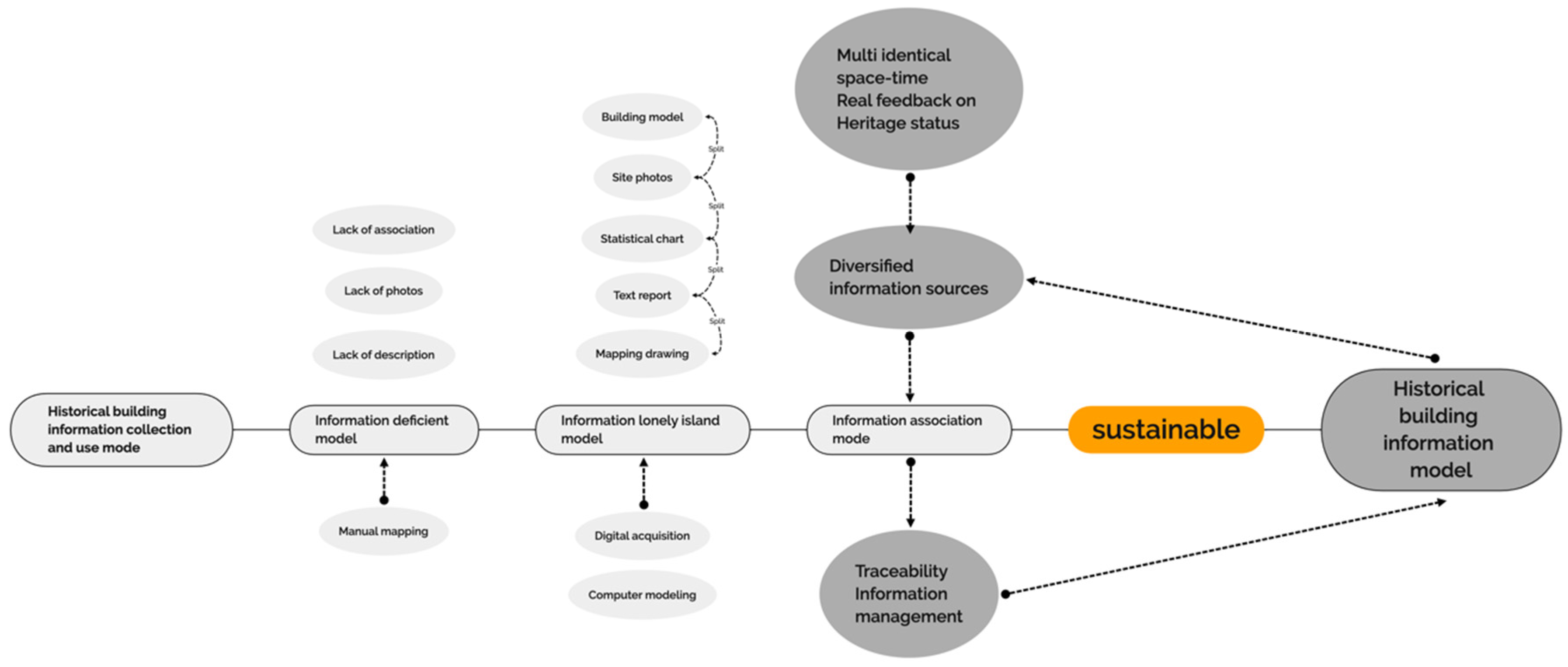
2.2. Methods for Recording Chinese Architectural Heritage Information

The conventional method is ‘real scene replication technology’ based on laser scanning instruments (triangulation, phase comparison, time of flight scanners) to collect heritage information data, that breaks through the conventional manual surveying and drawing recording methods, and realises the construction of architectural surveying and mapping information from a two-dimensional perspective with a revolutionary leap to three-dimensional, four-dimensional, and even multi-dimensional perspectives [15]. Using the point cloud data collected in this way, through data cleaning, resampling, optimising data, filling holes, correcting edges, and adding texture mapping, a mesh surface model recording the real historical building structure is generated, and the visualisation of heritage mapping data is realised. However, this set of methods has certain limitations. Its model maturity (maturity level to evaluate, including three levels: level 0 refers to manual surveying and mapping with a tape measure and level to obtain information, drawing it into a non-standard format CAD electronic document, and printing it as a paper drawing for delivery; level 1 refers to the use of an electronic distance meter (EDM—usually referred to as a total station) to acquire data and draw it into a standard format CAD electronic document (two-dimensional or three-dimensional); level 2 refers to obtaining three-dimensional data with a laser scanner, transmitting to multi-professional cooperation, standardised, parametric 3D modelling software for information modelling, but through standard exchange formats or tools, such as IFC format, to communicate and cooperate with other disciplines) is only level 2 and LOK100 (knowledge content (level of knowledge—LOK) evaluation model: the point cloud obtained by the laser scanner is regarded as LOK100; after the preliminary classification of components, the external database is linked to be regarded as LOK200; LOK300: further enriched depth of the model and information, including the results of in-depth research in different disciplines for diagnosis and monitoring; LOK400 includes conservation and intervention measures for built heritage, provides specific information on the standards and procedures; using HBIM processing for effective management, the different operation steps in the system’s registration scheme is regarded as LOK500) (level of knowledge) and cannot meet the delivery standards of building information models, similar to Dr Murphy’s thesis on 3D visualisation models and point cloud data. He regards the BIM information model only as a ‘supplement’ to photos and text reports and does not take advantage of the information management advantages of HBIM applications. This problem is mainly due to many practitioners’ lack of understanding and managing multi-temporal, diverse, and complex heritage information. This directly affects the development of HBIM towards sustainable records and management.

2.3. HBIM Sustainable Recording Method and Requirements

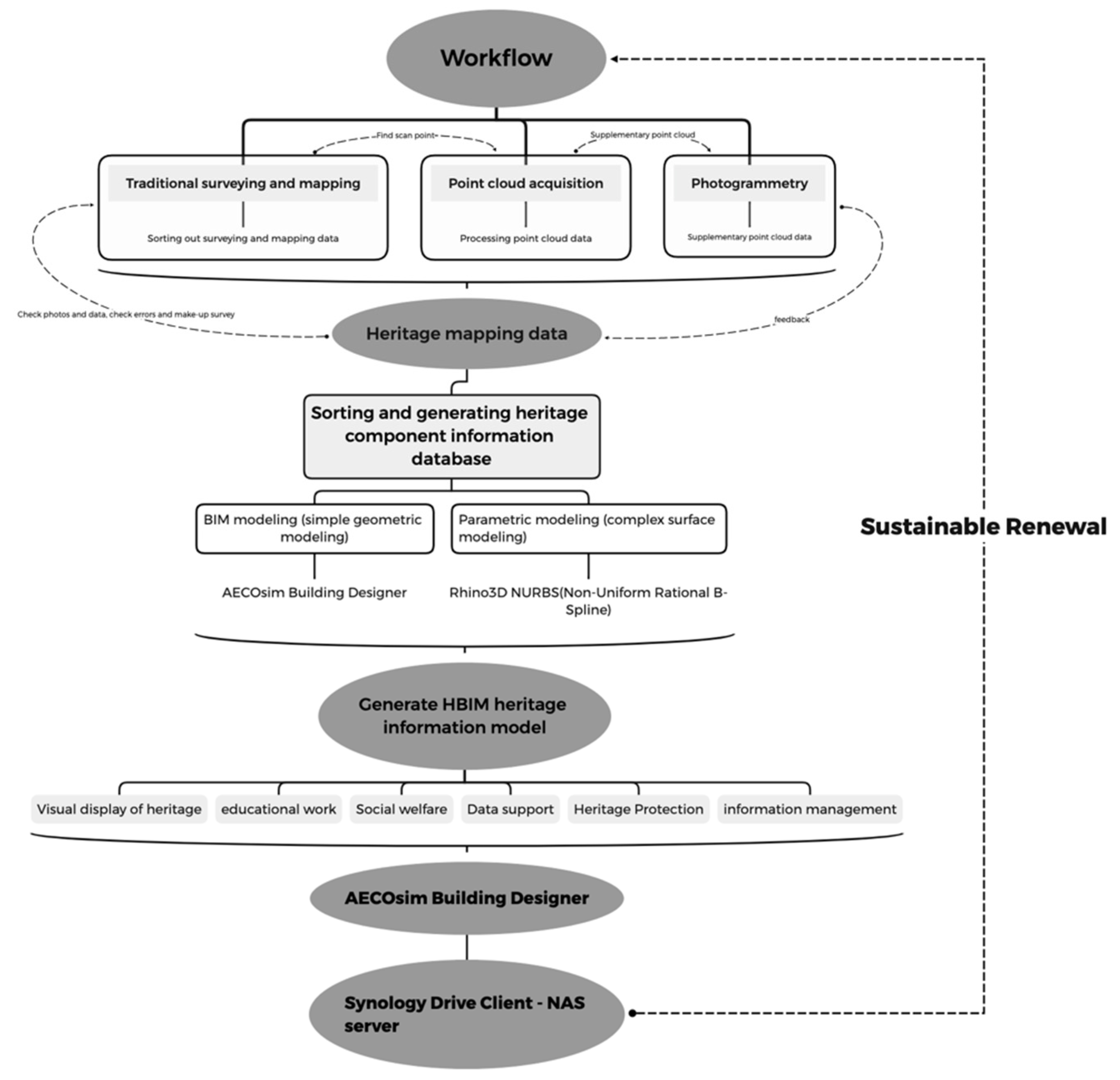
2.3.1. Surveying and Mapping Research and Data Acquisition

Firstly, use traditional surveying and mapping methods and photography to carry out on-site survey and drafting work, and use it as a compensation mechanism to make up for the detailed data and status of buildings that cannot be recorded in the work creation scanning instruments and equipment, and try to understand and sort out the space, structure, decoration of historical buildings, as well as construction logic, form features, distinctive features, and colour textures. These will help the later archival collation and HBIM model to overlap, as well as more complex heritage information sustainable input and update; secondly, with the help of the 3D laser scanning instrument, the point cloud scanning work is carried out along the set sequence, route and point position, and the final scanning results are classified into different categories through the editing method of cutting and interception, and different point cloud parts can be used as a reference to guide the construction of the HBIM information model. UAVs (unmanned aerial vehicles) can also be used to supplement the shooting of hidden parts of historical buildings and parts that are not accessible due to objective conditions, and use ‘photogrammetry software’ to generate point clouds to supplement the lack of laser scanner point cloud data. This step is carried out in conjunction with manual mapping work.

2.3.2. Construction and Transformation of Architectural Heritage Information

On this basis, the HBIM is constructed with the help of BIM software and the data obtained from the previous site surveys and mapping, literature research, and follow-up interviews, such as building form analysis, component disease investigation, historical documents, and photos in addition to maintenance project files, value assessment, and other data information. This information will be entered into the information model one by one and meet the requirements of the ‘Building Information Model Design and Delivery Standards’ (GB/T 51301-2018) level 3.0 model fineness (LOD3.0) (level 1.0 model precision (LOD1.0): project-level model unit (carrying project, sub-project or local building information); 2.0-level model precision (LOD2.0): function-level model unit (carrying complete functional modules or spatial information); level 3.0 model precision (LOD3.0): component-level model unit (carrying a single component or product information); 4.0-level model precision (LOD4.0): part-level model unit (carrying part information belonging to a component)), level 3 geometric expression accuracy (level 1 geometric expression accuracy (G1): geometric expression accuracy that meets the requirements of two-dimensional or symbolic identification; level 2 geometric expression accuracy (G2): geometric expression accuracy that meets rough identification requirements such as space occupation and main colours; level 3 geometric expression accuracy (G3): geometric expression accuracy that meets the needs of fine identification in construction and installation processes, procurement, etc.; level 4 geometric expression accuracy (G4): geometric expression accuracy that meets high-precision identification requirements such as high-precision rendering display, product management, and manufacturing and processing preparation), level 4 depth of information (level 1 information depth (N1): should include the identity description, project information, organisational role and other information of model units; level 2 information depth (N2): should include and supplement N1 level information, adding entity system relationships, compositions and materials, performance or attributes level 3 information depth (N3): should include and supplement N2 level information, increase production information and installation information; level 4 information depth (N4): should include and supplement N3 level information, increase asset information and maintenance information), and LOK500. Through light-weighting, the information model can also form data and other graphic data that conform to the IFC standard (Industry foundation class (IFC) produced an industry alliance with Autodesk in 1994 to define a unified and extensible data format for building information for interaction between building, engineering, and construction software applications. The IFC file format is determined by buildingSMART ® maintenance, which establishes international standards for importing and exporting building objects and their attributes, improves communication, productivity, and quality throughout the building life cycle, and reduces delivery time) and convert it into the BIM data management and results delivery system, giving full play to the information management and interaction advantages of HBIM.

2.3.3. Sustainable Information Recording and Protection Testing

Finally, different groups build a shared and sustainable interaction platform through the NAS server in the modelling process. The model data of each working platform is uploaded to the NAS server for storage, so the local data of each working platform is continuously updated synchronously with the NAS server. The model data between different working platforms can be checked, referenced, and displayed through the AECOM building designer (ABD) to realise the sustainable management and sharing of the heritage information model and give full play to the information management and interaction advantages of the HBIM model.

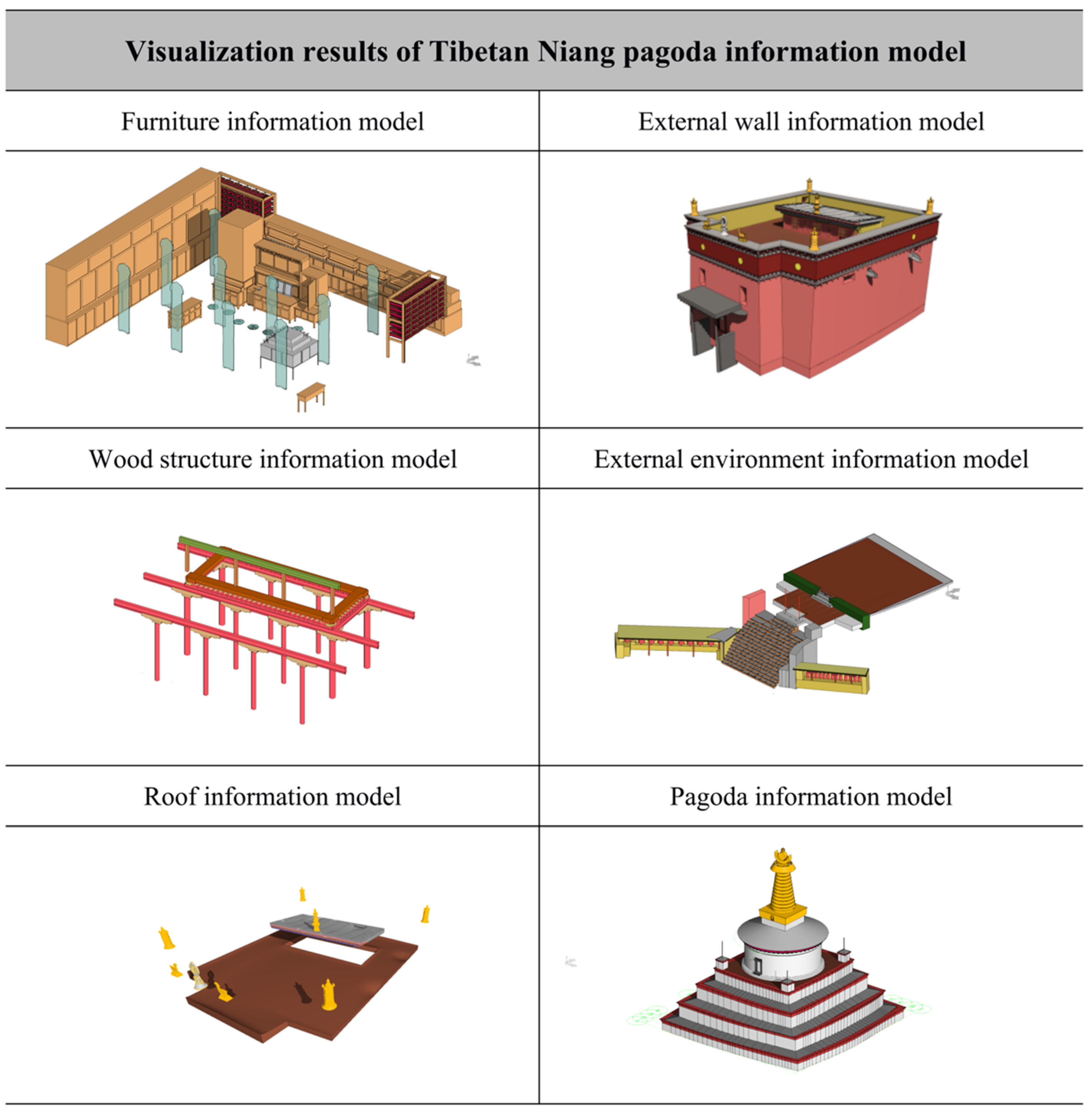
3. Construction Process of Information Model of Zangniang Stupa and Sutra Hall

The most significant advantage of the HBIM technique is that it can systematically archive, organise, and manage complex, diverse, and multi-temporal information of heritage elements. It emerged based on the traditional methods of surveying and mapping, which were characterised by inefficiency, poor coordination, and minimal sharing. It supports more systematic storage and management, more convenient analysis and querying, and more flexible and friendly sharing of information on architectural heritage. In addition, it can also use the ABD and NAS server to realise a sustainable collaborative work mode (Figure 2).

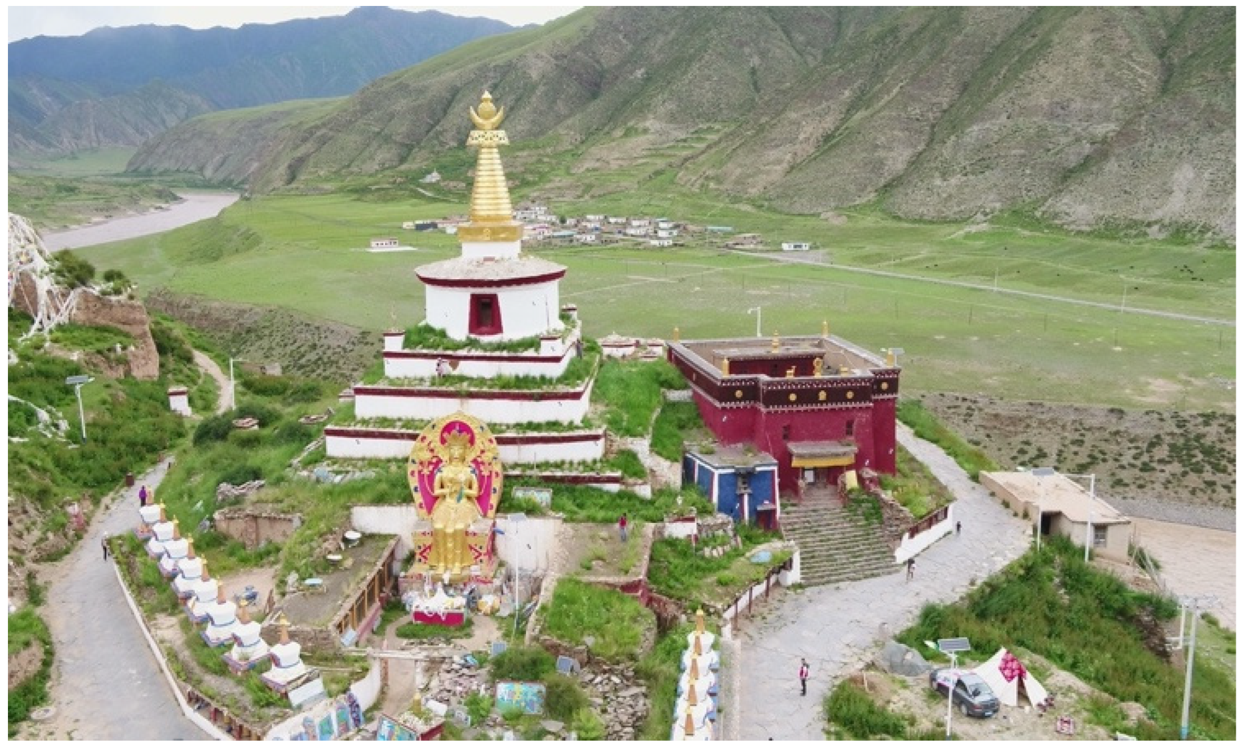
3.1. Field Surveying and Observation

In Tibetan, the name of the Zangniang Stupa means the ‘Zangniang Stupa of Shengde Mountain’ (Figure 3). It was built by the Indian master and missionary Pandita Smriti in the 12th century. The field survey and initial drawings of the Zangniang Stupa and Sanzhou Lamasery covered the wooden structure, roof, doors, and windows of the Sutra hall and the foundation, dome, spire, and pinnacle of the stupa. With the naked eye, we conducted observations and analysis of the construction logic and structural features, and the spatial relationship between and types of components, and recorded this as sketches, photographs, and a components list. Parts of the hidden building or whose location has limited accessibility due to objective conditions were rendered blank. The on-site drawings provided a general overview of the balance between preservation (differentiation) and the shape and construction logic (regularity) of the stupa and Sutra hall. We preliminarily mastered the shape characteristics of pagodas and Sutra halls and performed preliminary planning for the component library (family library) modelled by HBIM to facilitate the entry of essential data and information such as component name, size, and serial number in the future.

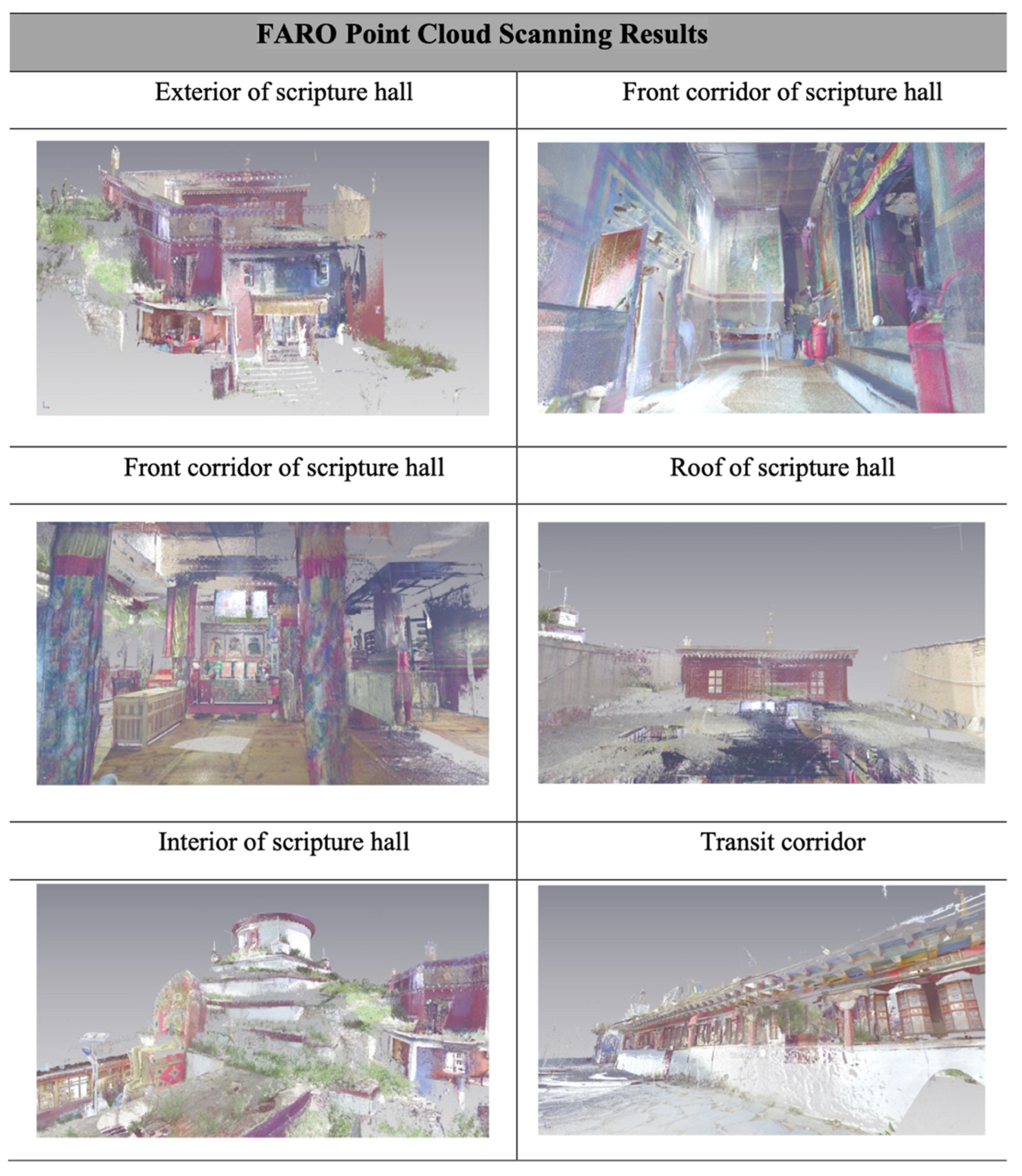
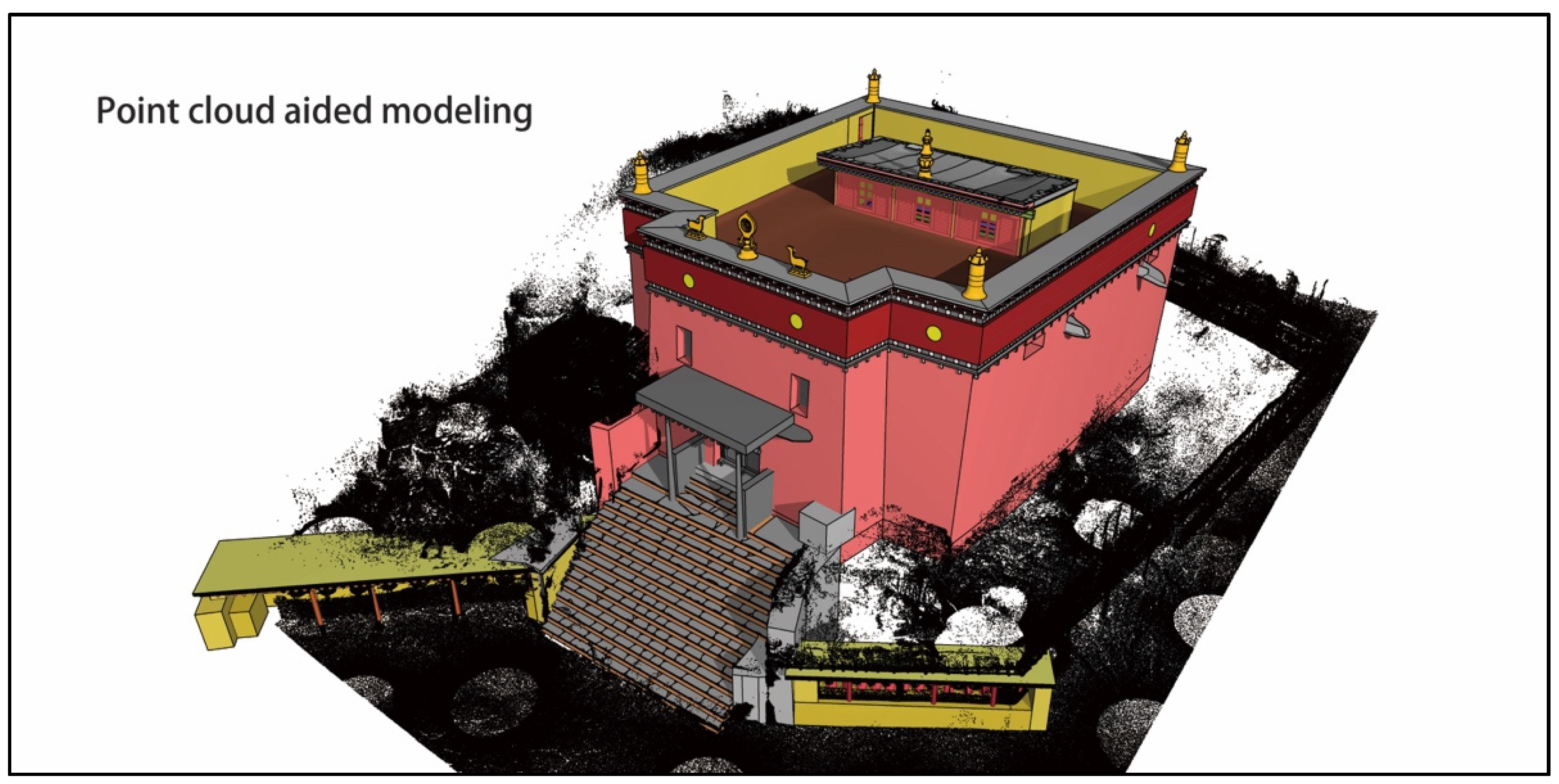
3.2. Point Cloud Scan and Adjustments

We selected appropriate scan positions and routes based on field surveys and observations, using a FARO portable 3D scanner (This instrument is capable of obtaining 976,000 points of the scanned object per second and can be operated simply and intuitively through a colour touch screen. The instrument also has a built-in coaxial high-resolution camera, which ensures no deviation between the colour image and the point cloud and increases the maximum scanning distance to 350 m. It has a 165-megapixel camera and, importantly, it stitches data in real-time at the scanning site) to scan 48 stations at the Zangniang Stupa and Sutra hall (Figure 4). However, this left some deficiencies. Due to the height of the stupa, it was decided to use drone photography to measure missing parts of the point cloud for the safety of the personnel. The point cloud needed to be systematically classified so that modellers could view it at any time. The point cloud was segmented according to the above-mentioned divisions of the individual buildings, with multiple people collaborating on the work.
During the HBIM work, the point cloud unit of measurement was generally set to millimetres. A point cloud can measure distance and elevation. The non-uniform rational basis spline (NURBS) model is used to capture curved surfaces, and a mesh is generated for complex surfaces, such as sculptures and fluctuating wall and ground surfaces. The point cloud can also generate an orthophotograph, that can be depicted as a corresponding two-dimensional line drawing—a standard CAD drawing; it can also assist in constructing the HBIM model. Standard point cloud data formats are .pts, .ptx, .pod, and .rcs, with .rcs used for Autodesk software, such as Revit and AutoCAD; .pod used for Bentley software, such as AECOsim Building Designer and Microstation, and .pts and .ptx commonly used as exchange formats.

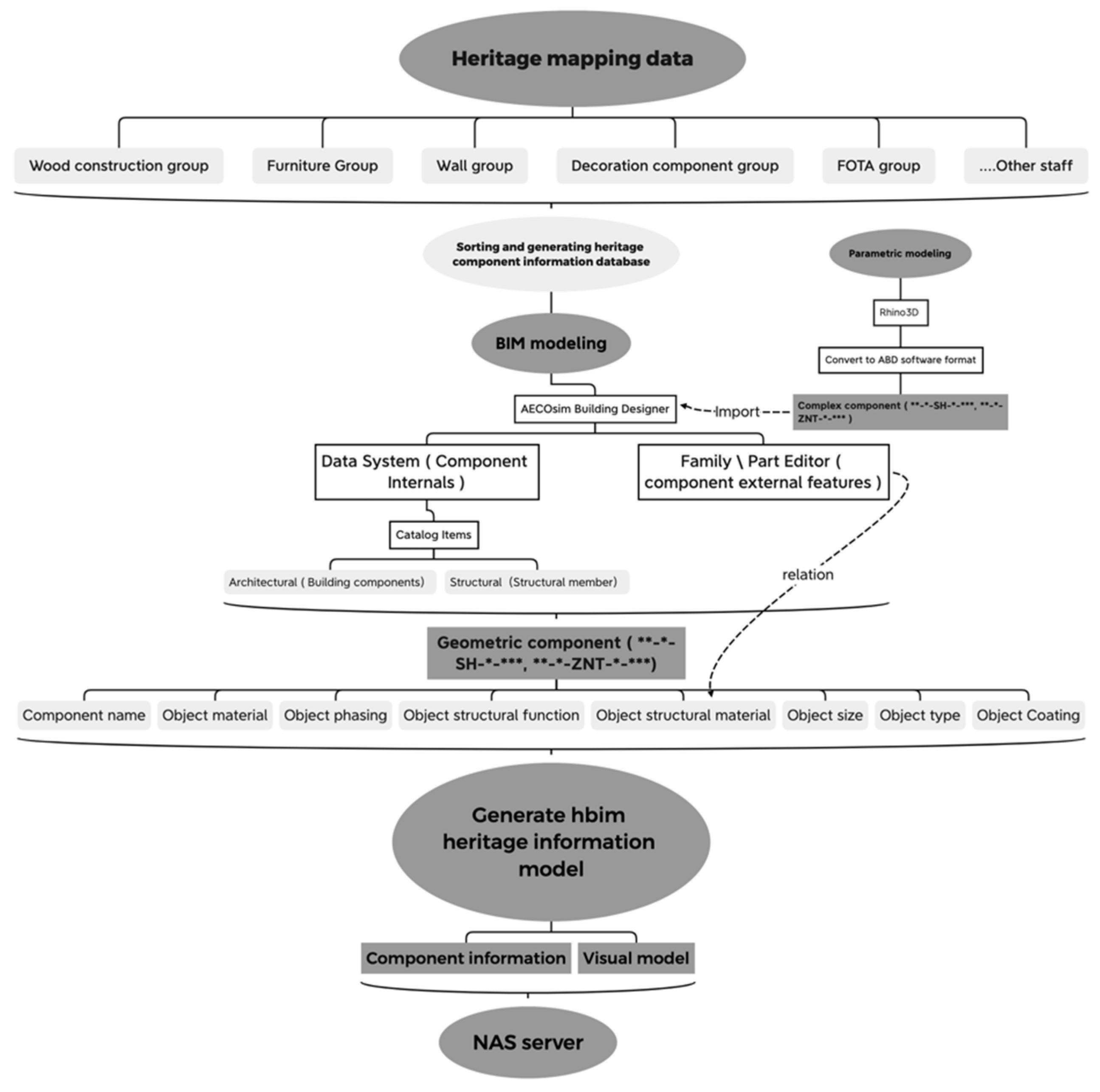
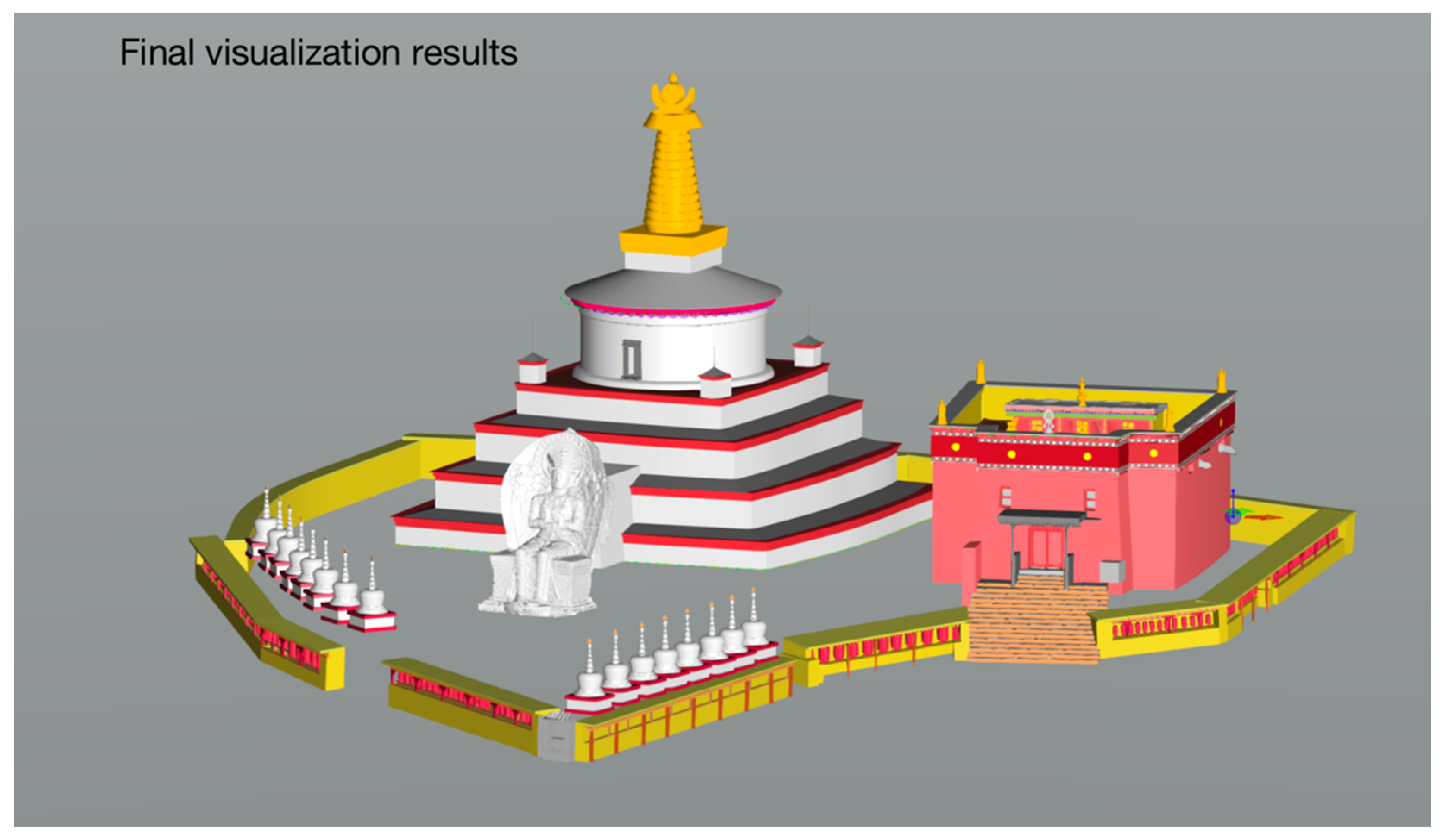
3.3. Build HBIM Sustainable Information Model

In the project of sustainable recording and protection of the architectural heritage information of the Zangniang Stupa and Sutra hall, we used a combination of the above platforms and software, including AECOsim Building Designer, Rhino, Synology Drive Client, Photoscan and Pointools (Figure 5). The specific work content and process are as follows:
(1)
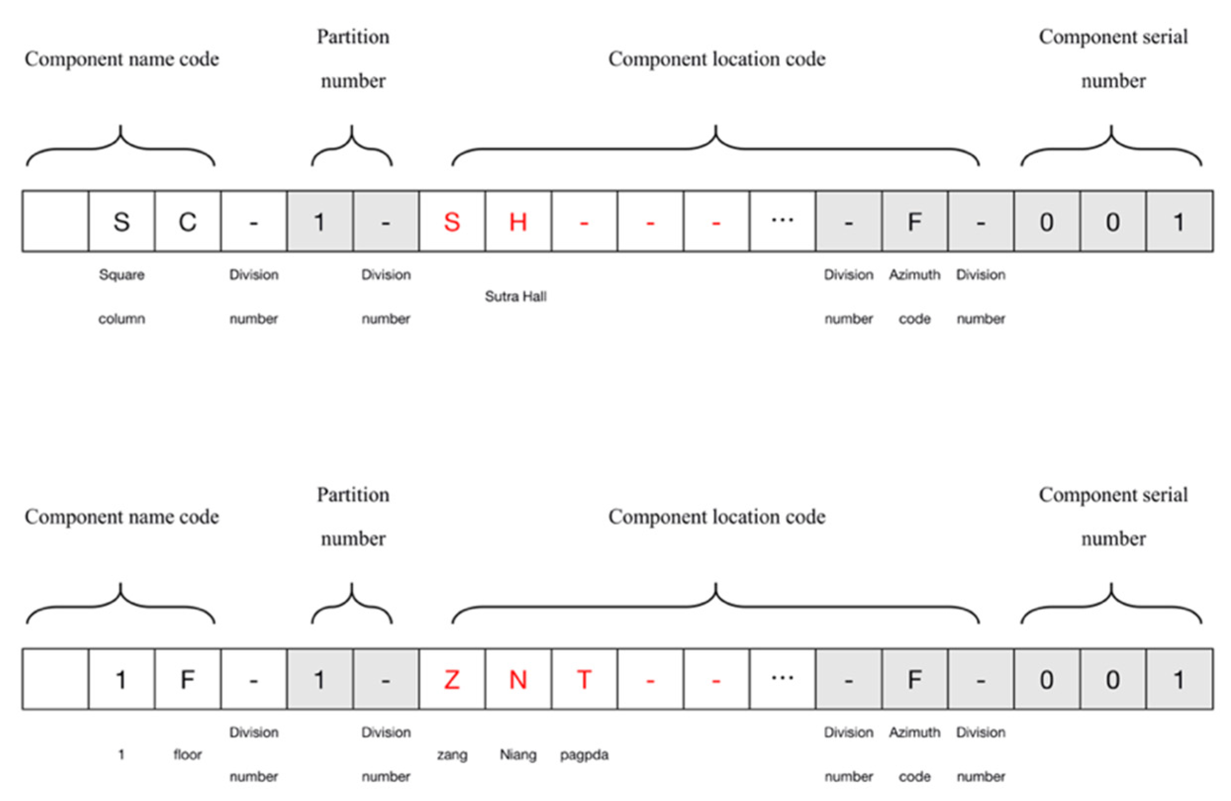
Step 1: Enter the component information database
Through classification and statistics, the building structure size data obtained by point cloud sectioning, field surveying, and mapping are filled into the Database Macro of the square ‘rectangular shape’ and circular ‘solid shape’ office in Excel. The naming method of each component is based on the initial letter of Chinese Pinyin, ‘Zang Niang Ta’ in uppercase, and the final naming format is “component name code-partition number-component location code (SH)-component serical number”, “component name code-partition number-component location code (ZNT)-component serical number” (Figure 6). Finally, the Database Macro file is entered into the information database of the AECOsim Building Designer, and the size data of each component in the library will directly support the HBIM information modelling and construction work.
(2)
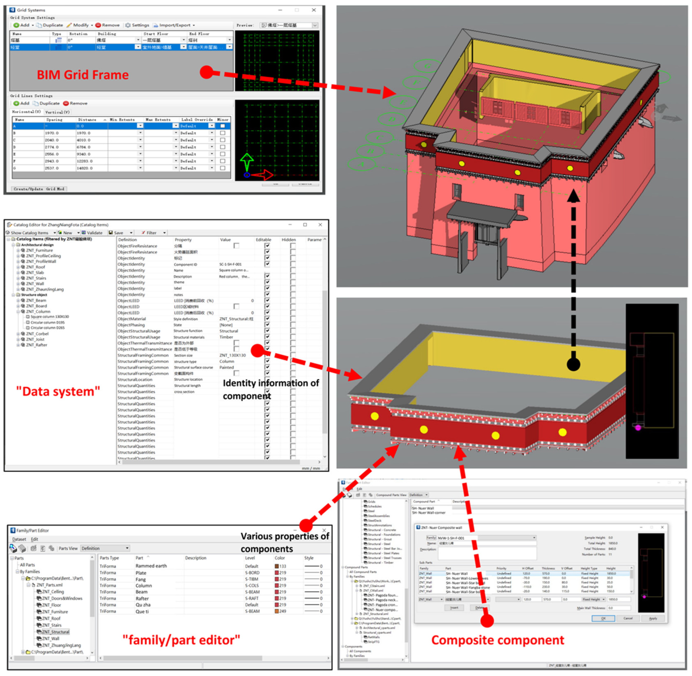
Step 2: Enter data system and family/part editor component information base
Enter the component database and the text information of the surveying and mapping site into the basic component information library of ‘data system’ and the component style library of ‘family/part editor’ (Figure 7). The ‘data system’ displays heritage information such as the name, size, surface, material, structural characteristics, and preservation status of building components. The ‘family/part editor’ displays the components’ colour, style, coating, and other information. In addition, with this command bar, you can also combine different parts with building complex building components, such as the temple building roof, and Bianma’s wall (earth wall), in this article. The different databases will become the main content and platform of sustainable information management in the first and second steps.
(3)
Step 3: Synology Drive client online collaboration
In the process of building an information model, ABD can be matched with Synology Drive client software, and each modeller can undertake its surveying and mapping on their local platform, and different modellers can also refer to each other’s modelling results, to reduce work errors and avoid repetitive work.
For example, the wall can be referred to as a wooden structure to determine the alignment relationship between them. Modellers will cooperate with detection equipment and early warning equipment to continuously update, replace, and edit component data information in future heritage protection work.
(4)
Step 4: Build the HBIM model
The ABD adheres to the workflow of building component processing and building assembly throughout the modelling process. Each component must be extracted from the professional component library based on the data system and family/part editor data information (Figure 8). Refer to point cloud, photogrammetry, and CAD drawings for precise movement and rotation sectioning, machining and splicing (Figure 9). During the entire modelling period, Rhino software can be used with ABD for some complex and curved components and completely different components (Figure 10), and can finally assemble them into the HBIM information model (Figure 11).
On a macro level, the modelling process allows us to understand each component’s functional role (load-bearing, overlap, properties, etc.) in the entire historical building and historical environment. On a micro level, we can fully understand each component’s meaning and deep logic (size, colour, material, etc.). In general, the construction of an information model is meaningful for the follow-up of sustainable management and protection.

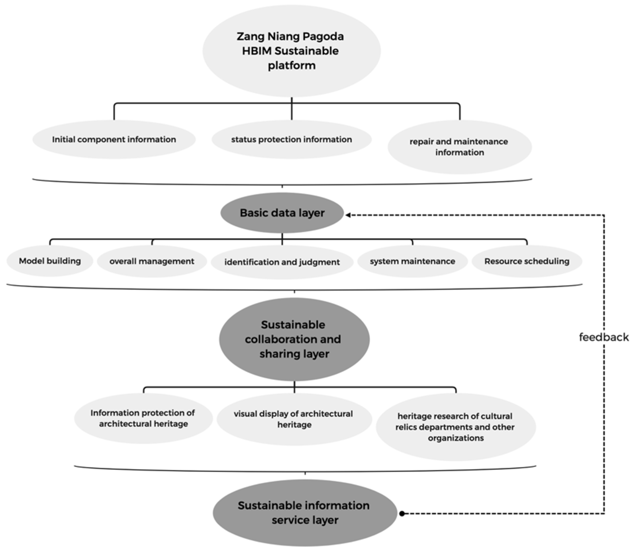
4. HBIM Sustainable Information Recording and Management Platform of the Zangniang Pagoda and Sutra Hall

According to the requirements of architectural heritage information protection and management, combined with the main functional requirements of the Zangniang pagoda and Sutra hall in the process of operation and maintenance management, the functional framework of the HBIM information management platform of these structures is preliminarily established, that is divided into three levels from bottom to top: basic data layer, sustainable collaboration and sharing layer, and sustainable information service layer (Figure 12). In addition, the current platform functions are still limited by BIM software technology and functions. The main reason for this problem is that BIM software technology is mainly aimed at the project management of ‘new’ buildings, not specifically developed for ‘architectural heritage’, so the current BIM software technology and functional modules cannot fully meet the needs of all heritage information types and protection and management. Nevertheless, in the heritage information input and management of the Zangniang pagoda and Sutra hall, this paper successfully built an HBIM information model in line with the delivery standard, using ABD, and successfully practised the ‘sustainable’ information management and protection combined with Synology Drive software, as well as the replacement of new and old heritage records. This method can not only realise the sustainable functions of information exchange, information query and resource sharing without being limited by location, time, capital, and personnel but also be widely popularised now and in the future.
(1)
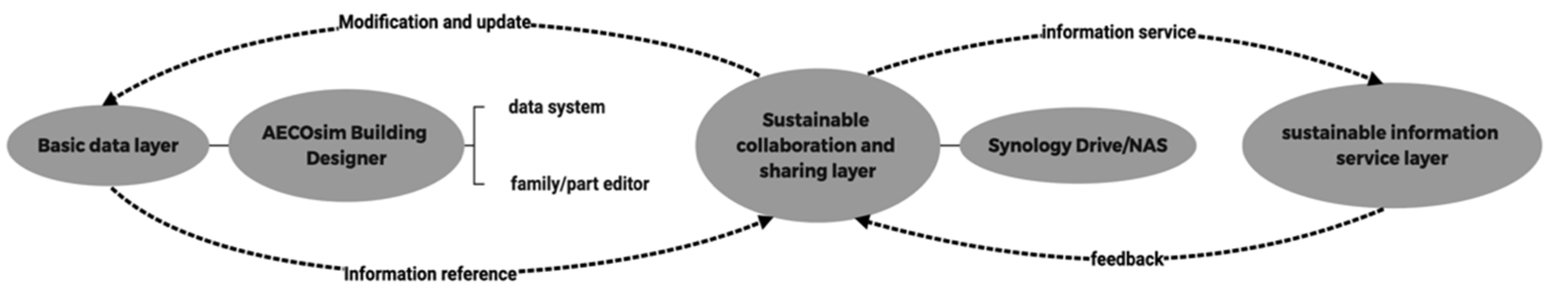
The basic data layer is mainly based on a ‘data system’ and ‘family/part editor ‘ that includes three parts: initial component information, current situation protection information, and repair and maintenance information of architectural heritage components. The initial component part needs to be input into ABD one by one in combination with the current component attributes of the current Zangniang pagoda and Sutra hall; for the status quo protection part, it is necessary to record the current status of all components, environmental status, other decorative components and the current damage of different parts as much as possible. The repair and maintenance part needs to be recorded into the system as much as possible in combination with the repair and protection records of different years. The above three parts are the basic data layer of the sustainable information protection and management platform of the Zangniang pagoda and Sutra hall.
(2)
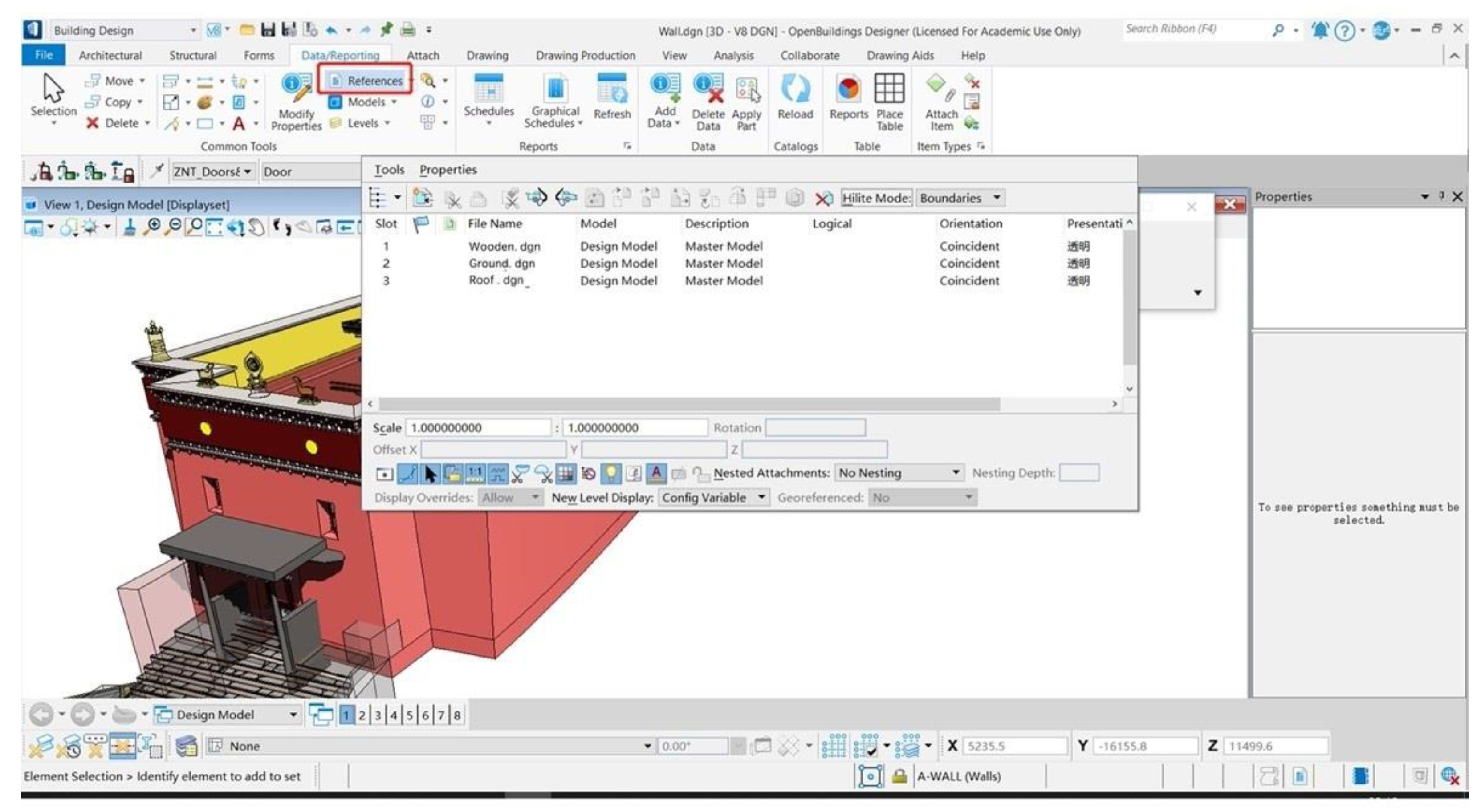
The sustainable collaborative sharing layer is the sustainable collaborative work layer (Figure 13), the platform jointly built by ABD and Synology Drive. It is the link between the database and sustainable information service layers and plays the role of overall management, identification and judgment, and system maintenance. After receiving the instructions from the sustainable information service layer in the future, the task status management, maintenance, and resource scheduling between different role groups can be implemented through the combined platform of ABD and Synology Drive, as well as the commands of data retrieval, import, and modification in ABD. Especially in the future, all groups can refer to the work achievements of different groups through ABD to reduce repetitive work (Figure 14).
(3)
Sustainable information service mainly provides data exchange in IFC format. Its data services are aimed at information protection of architectural heritage, visual display of architectural heritage, heritage research of cultural relics departments and other organisations, and so on. Of course, the feedback and instructions in the service process will also carry out the work of the basic data layer through the sustainable collaborative sharing layer. For example, the problems of component replacement and damage in the protection process of the cultural relics protection department will also be modified through the operation of the sustainable collaborative sharing layer.

4.1. Software Selection for HBIM Sustainable Recording and Management of the Zangniang Pagoda and Sutra Hall

This study primarily used AECOsim Building Designer software to build the model. This software is different from BIM software such as Revit and Rhino. Rhino has the advantages of parametric modelling and BIM function but does not have a BIM management function. Although Revit is a widely used software, it cannot be compared with AECOsim Building Designer in terms of internal storage architecture, software processing speed, software support format, software function module, creating special-shaped components, and compatibility of multiple files formats and so on. Revit software is not even well compatible with AutoCAD DWG format.
Of course, ABD is not software developed for ‘existing’ architectural heritage, but it has excellent file compatibility and supports almost all file exchange formats on the market. Its powerful modelling and management function can ensure the safety of our architectural heritage information model in the process of input, exchange and management.
The sustainable recording and management of AECOsim Building Designer mainly realises the model information file through the NAS server and automatically and seamlessly synchronises the model information file between multiple devices. Of course, establishing a NAS server is conducive to the transmission of a variety of files. Its combination with AECOsim Building Designer is also conducive to a remote office, discussion, modification, and management between different teams and different personnel.
At present, the NAS service market has been monopolised by Synology and QNAP. Synology is selected in this study because the software cannot only use Quick Connect Service to realise ‘Intranet penetration’, but also Synology Drive to realise the functions of automatic file synchronisation, seamless connection to cloud office, file multi-version protection (to prevent accidental deletion and modification), and real-time team editing of forms and documents.

4.2. HBIM Sustainable Recording and Synchronisation Method for the Zangniang Pagoda and Sutra Hall

AECOsim Building Designer software, as a platform for visual display of information model, sustainable information management, and seamless collaborative work, mainly relies on the two kernel files of ‘data system’ and ‘family/part editor’, which link all parts of visual model information. These two files are also stored in the ABD folder’s design (model style) and standard (model information) folders, respectively. Only by synchronising these two folders to different local working platforms with the help of Synology Drive can sustainable information management and collaborative work be realised (Figure 15). The file path is as follows: configuration/workspaces/ZnT/worksets/designs & standards.
The steps for setting the Synology Drive are as follows:
(1)
After installing the software, open it and select ‘synchronisation task’.
(2)
Link to the synchronisation NAS and start data synchronisation. In this step, you must enter the public IP address and enable SSL data transmission encryption.
(3)
After logging in, set local synchronised folders (different AECOsim Building Designer working platforms) and shared folders for team cooperation.
(4)
When enabled, synchronise according to team needs. You can select real-time synchronisation or on-demand synchronisation.
The HBIM sustainable information management and protection platform built with Synology Drive and AECOsim Building Designer are cheap, convenient, efficient, and easy to popularise to more people with limited funds or willing to carry out HBIM work, including many remote areas and schools.

4.3. A Sustainable Process for the Detection, Updating, and Delivery of HBIM for the Zangniang Pagoda and Sutra Hall

The HBIM sustainable information recording and management platform mainly has three functional frameworks, and the most important of these is the ‘basic data layer’ and ‘sustainable information service layer’, especially the basic data layer, which needs to detect, update and replace the information model. Only by ensuring the security and effectiveness of the basic data layer can we better deliver the sustainable information service layer and realise the sustainability of HBIM detection, update, and delivery.
The main methods and contents of heritage information model detection are as follows:
(1)
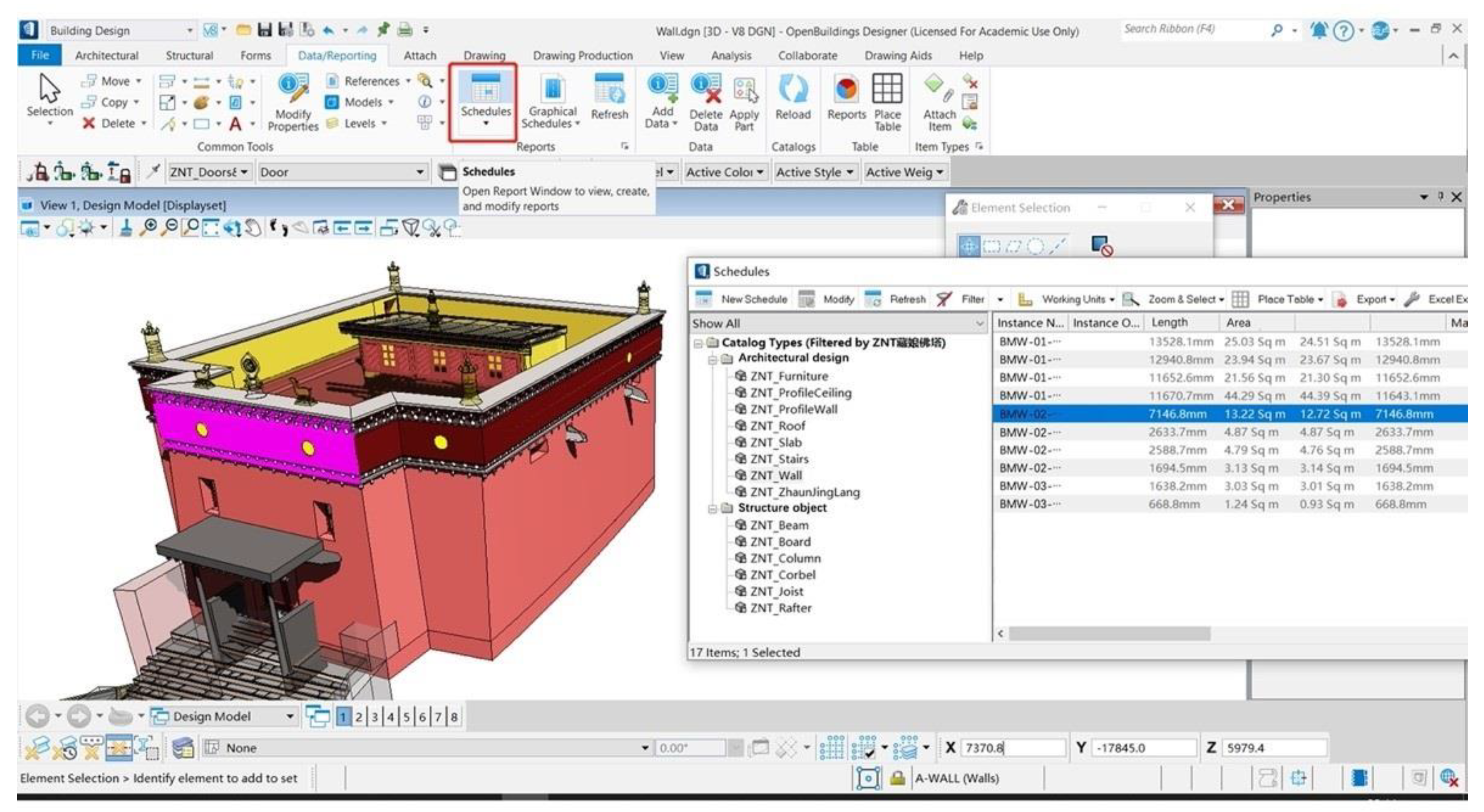
Check whether there are missing components, incorrect size, component overlap and other problems in the HBIM model by clicking on the three-dimensional model in ABD. The ‘schedule’ function interface also has the same function (Figure 16). For example, the actual number of columns is 20, while the ‘schedule’ function interface displays 21, so it is easy to find out.
(2)
Check whether the information contained in the HBIM model is accurate through the schedule function interface in ABD, including component history, component material, repair record, damage record, and other information.
The main methods and contents of heritage information model updating are as follows:
(1)
Based on the current situation and value evaluation standards of the Zangniang pagoda and Sutra hall, if it is required to update and modify HBIM model information, it is necessary to operate in the data management terminal in ABD, namely ‘data system’ and ‘style system’ (Figure 7).
(2)
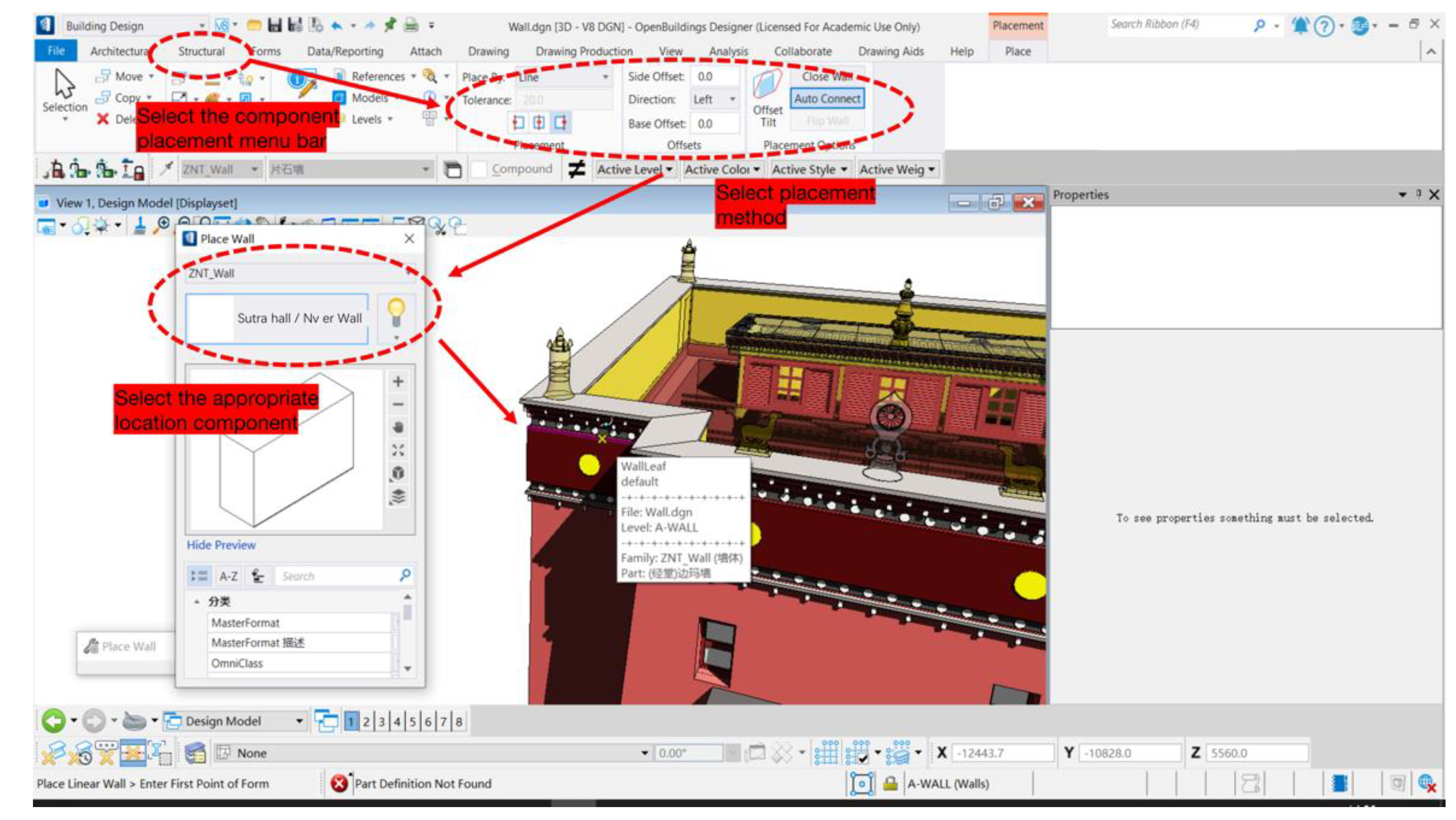
Based on the current situation and value evaluation criteria of the Zangniang pagoda and Sutra hall, if component information needs to be added, it can be assembled into the model based on the ‘architecture’ and ‘structure’ functional interfaces in the menu bar (Figure 8).
(3)
Through the ‘schedule’ function interface, find the components to be replaced according to the component information ID (name, orientation and number), and replace them into the model based on the ‘architecture’ and ‘structure’ function interfaces in the menu bar.
(4)
For components without component identity information, you must manually add and match information through the ‘data/report’ function interface in the menu bar. Of course, this method is also applicable to the sustainable input of future information on architectural heritage.
(5)
In the future protection process, we can use remote detection instruments to collect all-around information, such as fracture, moth-eaten, displacement, and decay of architectural heritage components. This information can also be entered with updated software and technology.
The main methods and contents of heritage information model delivery are as follows:
Once the HBIM model of the Zangniang pagoda and Sutra hall meets the standard of architectural information modelling design delivery standard (GB/T 51301-2018), it can provide information services for research and exhibition in other fields in a more compatible ‘IFC’ format through the ‘sustainable information service layer’.

4.4. Basic Requirements for HBIM Sustainable Recording and Management of the Zangniang Pagoda and Sutra Hall

(1)
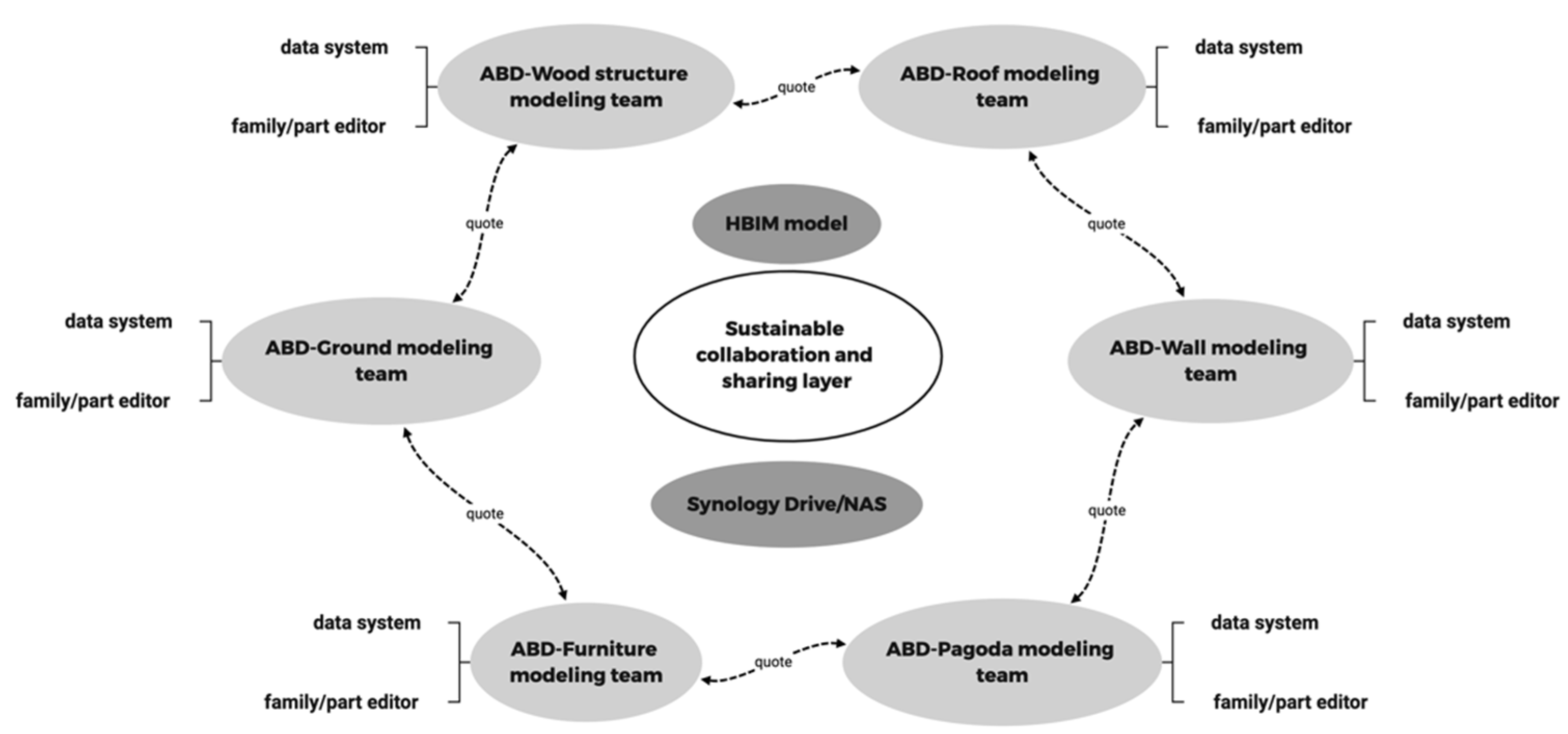
In the case of real-time synchronisation of information, everyone must strictly abide by the work assignment and progress. This is mainly due to the large amount of architectural heritage information collected, and the earlier that the ‘sustainable’ entry work is carried out, the better. The six groups must be in step in information modelling. Otherwise, the information interaction between different groups will be affected. For example, the wood construction team needs to quote the information model of the wall team and combine the point cloud to judge the exact location of the wood construction to avoid the ‘node dislocation’ of the model in the process of building the information model. The imbalance of work progress will affect the speed of making the whole information modelling.
(2)
When synchronising information on demand, everyone should save their model files and legacy information in time to avoid a power failure, network disconnection, software crash and other emergencies, and minimise data loss. It is not allowed to update the model information for long intervals to avoid occupying a large amount of network bandwidth due to too large files, this would affect the synchronisation work.
(3)
Anyone should carry out HBIM activities on the ABD platform in strict accordance with general logic, rules, and operations to avoid the problems that the position of model components cannot be joined, overlapped, and assembled, as well as the issues of model information mismatch and model information loss. In particular, many internal components and construction methods in the architectural heritage do not have standardised production and assembly procedures, which leads to different forms of many architectural structures and spaces. Therefore, if they are not operated according to the specified process, the subsequent detection, renewal, and delivery work will often be affected.

5. Summary

This paper realises AECOsim Building Designer and Synology Drive’s sustainable recording, preservation, and management of architectural heritage information. At the same time, we also put forward a new ‘collaborative’ working mode to realise the on-demand, real-time sharing and transmission of the heritage information model of the Zangniang pagoda and Sutra hall, effectively avoiding the repeated modelling and investigation work of different staff, and provide a feasible scheme for more government institutions and scientific research teams in remote areas to realise sustainable HBIM. However, we still found many problems in the research process that need to be further investigated in the future:
(1)
At present, HBIM is still limited by BIM software technology, and the BIM software and display platform specially developed for the characteristics of ‘architectural, cultural heritage’ has not been developed.
(2)
The BIM component library dedicated to architectural heritage has not yet materialised, which leads to the need for manual modelling and adding information to many ancient architectural component models. This would hinder the sustainable development and use of HBIM to a certain extent.
(3)
Architectural heritage has many diversified information categories and value elements. The types of information sources highlighting these elements are also diverse, including audio-visual, photos, drawings, reports, etc. Therefore, the current HBIM model cannot fully show all these elements.
However, this paper practices and tests the possibility of ABD and Synology Drive in HBIM sustainable information recording and management from the results and conclusions. This model ensures the real-time, open, visual, integrated and sustainable heritage information model of the Zangniang pagoda and Sutra hall, and also proves that ABD and Synology Drive is still one of the best ways for sustainable recording and management of HBIM architectural heritage information in terms of compatibility, operability, and stability.

Author Contributions

Validation, C.X. and Y.Z.; resources, C.W.; visualisation, C.X and Y.Z. All authors have read and agreed to the published version of the manuscript.

Funding

The research funding is come from National Natural Science Foundation Project ( grant number: E080102): Study on BIM-based technical framework for informatization ofarchitectural heritage documentation, Sponsor: Cong Wu.

Institutional Review Board Statement

Not applicable.

Informed Consent Statement

Not applicable.

Data Availability Statement

Not applicable.

Acknowledgments

Thanks to Zhao Yi for proofreading and providing suggestions on the English grammar in this article, Wu Cong for permission to use the survey data, and for suggestions on the structure and method of the paper.

Conflicts of Interest

The authors declare no conflict of interest.

References

  1. Murphy, M.; McGovern, E.; Pavia, S. Historic building information modelling (HBIM). Struct. Surv. 2009, 27, 311–327. [Google Scholar] [CrossRef] [Green Version]
  2. Zhang, W.J. Research on applying HBIM in Lifen architecture conservation. Master’s Thesis, Huazhong University of Science and Technology, Hongshan District, Wuhan, China, 2018. Available online: https://hfffgc1d129f57bb244a4sx09cp65f995969knfgfy.eds.tju.edu.cn/KCMS/detail/detail.aspx?dbname=CMFD201901&filename=1018785112.nh (accessed on 28 December 2021).
  3. Andriasyan, M.; Moyano, J.; Nieto-Julián, J.E.; Antón, D. From point cloud data to building information modelling: An automatic parametric workflow for heritage. Remote Sens. 2020, 12, 1094. [Google Scholar] [CrossRef] [Green Version]
  4. Mora, R.; Sánchez-Aparicio, L.; González, M.A.; García-Álvarez, J.; Sanchez-Aparicio, M.; González-Aguilera, D. An historical building information modelling approach for the preventive conservation of historical constructions: Application to the Historical Library of Salamanca. Autom. Constr. 2020, 121, 103449. [Google Scholar] [CrossRef]
  5. Angulo-Fornos, R.; Castellano-Román, M. HBIM as support of preventive conservation actions in heritage architecture. Experience of the renaissance quadrant façade of the Cathedral of Seville. Appl. Sci. 2020, 10, 2428. [Google Scholar] [CrossRef] [Green Version]
  6. Diara, F.; Rinaudo, F. 2021. ARK-BIM: Open-source cloud-based HBIM platform for archaeology. Appl. Sci. 2020, 11, 8770. [Google Scholar] [CrossRef]
  7. Banfi, F.; Mandelli, A. Interactive virtual objects (IVOs) for next generation of virtual museums: From static textured photogrammetric and HBIM models TO XR objects for VR-AR enabled gaming experiences. ISPRS (XLVI-M-1) 2021, XLVI-M-1-2021, 47–54. [Google Scholar] [CrossRef]
  8. Zaker, R.; Eghra, A.; Pahlavan, P. Documentation and HBIM of industrial heritage using drone images: Petroleum reservoir of Mashhad. ISPRS (XLVI-M-1) 2021, LVI-M-1-2021, 917–923. [Google Scholar] [CrossRef]
  9. Mol, A.; Cabaleiro, M.; Sousa, H.S.; Branco, J.M. HBIM for storing life-cycle data regarding decay and damage in existing timber structures. Autom. Constr. 2020, 117, 103262. [Google Scholar] [CrossRef]
  10. Wang, X.; Wu, C.; Que, R. Regularized rebuild workflow of HBIM for built heritage documentation. ISPRS (VIII-M-1) 2020, 8, 193–200. [Google Scholar] [CrossRef]
  11. Cong, W.; Zhe, L. Information management in surveying and mapping records of architectural heritage. J. Archit. 2007, 5, 12–14. [Google Scholar] [CrossRef]
  12. Mingda, C. Ancient Chinese Wooden Structure Building Technology (Warring States-Northern Song Dynasty); Beijing Cultural Relics Publishing House: Beijing, China, 1992. [Google Scholar]
  13. Xinian, F. Research on the Layout and Architectural Design Methods of Ancient Chinese Urban Planning Buildings; China Construction Industry Press: Beijing, China, 2001; p. 208. [Google Scholar]
  14. Wu, C.; Li, K.; Li, S.J.; Zhang, L.; Bai, C.J. From digitization to informationization: The application of information technology in the field of architectural heritage. China Cult. Herit. 2016, 2, 18–24. [Google Scholar]
  15. Chengjun, B.; Cong, W.; Long, Z. Application of a full range of 3D laser scanning technology in cultural relics and archaeological surveying and mapping. J. Tianjin Univ. 2021, 5, 436–439. [Google Scholar]
Figure 1. Historical building information collection and use mode.
Sustainability 14 04549 g001
Figure 2. The process of HBIM modelling.
Sustainability 14 04549 g002
Figure 3. Zangniang pagoda and Sangzhou temple.
Sustainability 14 04549 g003
Figure 4. Point cloud data.
Sustainability 14 04549 g004
Figure 5. Multi-software collaboration.
Sustainability 14 04549 g005
Figure 6. Classification codes and standards.
Sustainability 14 04549 g006
Figure 7. Component information base.
Sustainability 14 04549 g007
Figure 8. Extract information components and assemble models.
Sustainability 14 04549 g008
Figure 9. Final temple HBIM model.
Sustainability 14 04549 g009
Figure 10. Final assembly HBIM model.
Sustainability 14 04549 g010
Figure 11. Visual information model results.
Sustainability 14 04549 g011
Figure 12. HBIM sustainable information recording and management platform.
Sustainability 14 04549 g012
Figure 13. Collaborative workflow.
Sustainability 14 04549 g013
Figure 14. Function interface for different modelling teams to reference model information.
Sustainability 14 04549 g014
Figure 15. Coordination between functional frameworks in sustainable records and management.
Sustainability 14 04549 g015
Figure 16. Function of schedule interface.
Sustainability 14 04549 g016
Publisher’s Note: MDPI stays neutral with regard to jurisdictional claims in published maps and institutional affiliations.

