1. Introduction
Urbanization is an increasingly apparent fact since more than half of the world population lives in cities. Cities, with all their positive and negative characteristics, are considered the main engine for modern economic development. Urban planners and policymakers have the critical and challenging role of achieving sustainable urban, environmental, social, and economic development.
The World Bank stated that once cities are built, their urban form and land-use patterns are locked in for generations [
1]. Cities could grow and expand relatively fast, but the process of dealing with all their negative effects is complicated and costly, and it takes a relatively long time to yield results.
Urbanization and urban development strategies are considered the core of any future sustainable growth plans. In their way of seeking economic development, most cities pass through three major phenomena: high population growth rate, high rate of urbanization, and, as a result, urban sprawl. Urbanization and urban sprawl (which are the main focuses of this paper) are usually related. In most cases, it is difficult for any urban agglomeration to achieve notable economic development without significant population shifts to cities. Industries and services in most cases are concentrated in cities to benefit from economies of scale. These sectors grow more rapidly than any other sectors and they attract people seeking better living standards and quality of life to the city.
There are many urban planning studies discussing and debating urban sprawl phenomena on a global level, but it has become more critical and controversial in the case of developing countries, which are still in the initial phases of economic growth.
The growth of urban areas is one of the major issues that most local governments and authorities attempt to manage and control. Recently, there has been a lot of discussion about urban sprawl and its consequences, such as city center decline, increased dependence on private vehicles in transportation and the increasing cost of infrastructure.
The Kingdom of Saudi Arabia faced the problem of economic frog jumps due to the volatility of the oil markets (its main source of income) which was highly reflected in the urban and economic development of most major cities in the country. Jeddah is the second largest city in the Kingdom of Saudi Arabia after Riyadh (the capital city). It accommodates more than 3.5 million inhabitants. In the past, Jeddah’s urban expansion fluctuated depending on government investments and was highly linked to the overall economic status of the country, which led to a tremendous urban growth taking the city from 300 hectares in 1947 to about 200,000 hectares in 2021.
The purpose of this study is to review and evaluate the implementation of the compact city model in Jeddah as a policy and to find out if the implemented policy succeeded to limit the urban sprawl. There is a strong relation between urban sprawl and lifestyles and improvement in living standards but from a sustainability point of view, the compact city model could provide the same benefit if supported by efficient infrastructure and proper urban planning regulations.
The study will define urban sprawl and its characteristics in addition to the main factors that led to it. Three major anti-sprawling models (New Urbanism, smart growth, compact city) will be presented and discussed. The case study section presents a detailed historical background of Jeddah’s urban development and the current challenges facing the municipality and infrastructure sector by analyzing one of the districts for which Jeddah municipally implements new regulation. The discussion section analyzes the results and findings of the case study and compares the outcomes to what was expected by the municipality and to the original model. Finally, the conclusions section summarizes all the results and highlights the main findings of the study.
2. Literature Review
Urban growth and urbanization together have shaped the modern history of civilization. In the year 2000, the global urban population was estimated to be around 2.9 billion, four times the number in 1950 (0.73 billion). The average annual global urban population growth rate during the second half of the 20th century was around 2.72 percent, which meant the world urban population doubled every 25 years, whereas the world’s population average growth rate is around 1.76 percent annually (and doubled every 39 years). The differences between those two rates of growth demonstrate the rate of global urbanization [
2].
Since the Industrial Revolution, urban sprawl has been seen as a bright indicator of the strong economic development of nations. Low population density, bigger plot size, single land-use pattern and automobile-dependent development reflected a better quality of life and living standards. Even today, with all the discussion and debate regarding the sustainability of urban sprawl phenomena, it is still preferable, at least from an individual and end-user perspective.
Governments and planning authorities have attempted to control and regulate the development of their cities. Policies such as “New Urbanism” and “smart growth” were applied in North America, whereas ‘compact city’ and ‘multifunctional land use’ policies were applied in Europe. However, both parties have admitted that there are difficulties in applying these policies and in measuring its success.
In most developing countries, urban planning authorities are used to apply classical urban planning methods and tools to manage the development of their cities. A classical planning framework should normally include structural, master, and sometimes regional or subregional planning efforts. These planning requirements are becoming increasingly costly and time consuming, and in the case of developing countries, where urban development and demographical changes are rapidly changing, a lot of these plans would become absolute by the time they were delivered to local authorities for implementation.
2.1. Urban Sprawl
2.1.1. Definition, Characteristics, and Origin
Among the literature on urban planning, there is much debate about how exactly urban sprawl should be defined. After reviewing many urban planning studies, it is difficult to identify a certain urban form for urban sprawl. Nelson attempted a comprehensive definition [
3]:
“unplanned, uncontrolled, and uncoordinated single-use development that does not provide for a functional mix of uses and/or is not functionally related to surrounding land uses and which variously appears as low-density, ribbon or strip, scattered, leapfrog, or isolated development”.
On other hand, there is agreement about the major characteristics that are associated with the term “urban sprawl”. Gillham identifies four main characteristics of sprawl to reflect Nelson’s definition [
4]: leapfrog or scattered development, commercial strip development, low density, and large expanses of single-use development. Leapfrog or scattered development is a type of urban development where an isolated community or urban development is created outside the urban boundary and in most cases surrounded by undeveloped land, with a great need to build highways and other infrastructure to serve it. It is important to clarify that leapfrog development is not the same as “satellite towns”. Both types share such characteristics as low-density development and a great reliance on automobiles for transportation. However, leapfrog development is a haphazard patchwork, widely spread apart, and completely reliant on the city for its amenities and services (schools, medical care, etc.). Commercial strip development is characterized by wide roads surrounded by shopping centers, gas stations, restaurants, banks, and office buildings. According to Gillham, “strip development” is very low density and automobile-dependent, with retail buildings configured in long, low boxes or in small pavilions which are always surrounded by large parking lots. Trips between the different retail outlets are mostly made by car, due to the spread-out nature of the strip, and there is little, if any, emphasis on the needs of pedestrians [
4]. Low density (Density measured in different way and methods. The most widely used methods are population density or sometimes dwelling units per area. Another useful measure is the floor area ratio (FAR) which is the ratio of the buildup area to the total land area) is the third and most important aspect of urban sprawl. Sprawl development buildings normally comprise one or two-story residential units, surrounded by intervening parking lots and roadways. Another characteristic of urban sprawl is that, in most cases, it is a single-use development and heavily depends on vehicles for transportation. Most negative environmental, economic, and social effects are an outcome of this. The single-use development was seen as representing better economic wellbeing and, from the other side, a response to issues associated with industrialized cities. Zoning legislation has emphasized and encouraged this type of development. Large spatial separation between different facilities and urban typologies mean that the best method of transportation is the private car. According to Nozzi, modern cities are designed to keep traveling by automobile as a necessity [
5].
Urban sprawl is a complex phenomenon. In addition to Gillham’s four aspects, he highlighted that lack of public space is an outcome of more private space-oriented developments which, from his point of view, is the characteristic that could identify a “sprawled” community from one that is not. In most cases, urban sprawl accommodates residential and nonresidential development that consumes a large amount of farmland and natural areas [
6]. Urban sprawl is seen by many as a logical response to the overall improvement of urban dwellers’ living standards, whereas others are ambivalent about it. Malizia believes that the idea of a single-family home on a large lot in the suburbs is still preferred by most [
7]. Others, for example, Burchell, see that such a development is not conductive to good quality of life in urban areas [
8].
Urban sprawl itself is not a new phenomenon. Mumford argued that “the suburb becomes visible almost as early as the city itself” [
9]. It is obvious that the type and characteristics of the suburb that Mumford referred to are totally different. It was in the 19th century when the two major urban development constraints disappeared, namely, fortification and limitation of mobility (before that, most trips had to be made on foot). As a result, cities and urban development became functions of transportation technology. Sprawl has been a dominant characteristic of most major global urban areas during the past 50 years. It is seen as a result of many economic, social, and technological factors.
To understand the role that new technology has played in decentralizing cities, it is important to review the three main stages (or time periods) that have shaped the development of our cities [
10]. In the beginning, cities were characterized by a small, walled dense urban structure and were not more than several kilometers from one end to the other. All cities’ dimensions had to consider that all residents’ destinations needed to be within acceptable walking distance. Later, the inventions of new modes of transportation (trains and trams) in the latter part of the 19th century enabled cities to expand at a much higher rate. As a result, train stations generated sub-centers which had the same walking effect characteristics illustrated previously. On the other hand, cities were developed according to tram and train routes, which led to a linear, grid-based development [
10]. The central business district (CBD) appeared in this period. It represents the central area of the city where all rail lines met. The privilege of being highly connected gave these CBDs the ability to attract all sorts of business and activities. The effect of this change could be seen in many of Europe’s North America’s cities, where urban development was shaped by old train and tram routes and stations until the invention of the automobile. Historically, cars were invented and gained popularity before the Second World War, but their dominance started afterward. Automobiles became the major transport mode for many residents, whereas buses were the most suitable choice for others. Automobile ownership per capita began to increase dramatically. In 1920, there was one automobile for every 11 people in the US; by 1930, this had dramatically changed to one automobile for every 4.5 people [
11]. In 2002, there was a car for every 1.23 people in the US [
12].
Cities today can be developed in any direction. It starts by filling in between the train lines and then going out as far as 50 km [
10]. The result is what can readily be observed in most western and modern cities: a total disconnection in terms of urban spatial development between homes and workplaces.
It is a general belief that urban sprawl is a result of changing lifestyles and improvement in living standards. However, from the previous historical illustration, no one can ignore how closely and strongly the rise in automobile ownership and urban sprawl are linked to each other. Having better, fast, and low-cost transportation means more mobility for labor and goods. It is important to highlight that there are many other factors that support and facilitate urban sprawl. It is true that urban development grows in favor of cars, but that would not be possible without continuous financial governmental support in building highways. There are many policies that facilitate and encourage urban sprawl. For example, the Federal Housing Administration and U.S. Department of Veterans Affairs loan programs in the US after the Second World War provided mortgages for over 11 million new homes. Duany believes that this program discouraged the renovation of existing housing stock, and placed great emphasis on the construction of single-family, detached houses, the foundation of low-density development [
13]. Another example could be seen in the form of federal investment in a 41,000-mile interstate highway program, which was coupled with “federal and local subsidies for road improvement and the neglect of mass transit” [
13]. Zoning regulation, on the other hand, contributed to the creation of single-use developments and spatial separation for the last 80 years. A lot of town planning and zoning regulation such as building regulations, street widths, backyard sizes, and building heights, intentionally in some cases and not in others, encouraged the dismantling of urban structures in the form of land-use separation.
Zoning was created to bring back some order to the industrialized city. Its main goals were to improve street conditions by bringing light and air back to them and, at the same time, increase property values by providing assurance about what might be built nearby [
4]. Since 1961, in New York City (Zoning was first introduced in New York City in 1916 to bring a sense of order to the industrialized city), zoning plans have focused mainly on gradations of land use, usually promoting low-density development as a strategy to improve living standards. As a result, the main effect of zoning could be seen in how modern city land use was separated and sometimes even isolated from other types of land use. It is undeniable that it was considered a great achievement to confine factories and railyards to “industrial zones” and put houses and apartments in “residential zones”. Such separation improved residents’ living conditions and reduced their exposure to air pollution and led to better health indicators.
It is obvious that urban sprawl accommodates and generates so many negative effects for modern cities’ development patterns. At the same time, it is important to note that there are many positive aspects of urban sprawl, which have clearly contributed to its popularity.
2.1.2. The Positive Side of Urban Sprawl
The benefits of urban sprawl are: new residential areas; new opportunities for developers and other stakeholders; and sometimes, if planned and managed well, it could provide some social benefits through developing more affordable housing and utilizing the low cost of land [
14]. Gordon and Richardson studied urban sprawl and concluded that it is a consumer preference, and people prefer living in sprawl areas over a more compact and “crowded” urban environment [
15].
However, urban sprawl is now seen as a negative urban phenomenon in most of the literature on urban planning. The main undesirable aspect of sprawl is excessive land consumption due to undervaluation of open space, congestion due to increased commuting, and socioeconomic segregation due to exclusionary housing markets [
16]. Furthermore, sprawl is now considered responsible for the significant fiscal cost for infrastructure provider agencies from both public and private sectors [
17]. Sometimes, it is even considered responsible for unbalanced public health services [
18].
On the other hand, urban sprawl has helped many parts of the population access less expensive, single-family homes on large lots while giving residents greater freedom of movement, whereas highway systems have been expanded. Indeed, Burchell and Mukherji point out that at the individual level, there are many benefits of living in a “sprawled” community; for example, large houses, an exclusive neighborhood, and multiple automobiles are symbolic of success [
17].
On the other side, urban sprawl is attractive to developers because it is generally more profitable than inner-city redevelopments. For developers, working in sprawling sites means that they do not have to bear the costs of removing what was previously on the site or upgrade the surrounding infrastructure, as that is usually paid for by the public through rates and infrastructure costs [
16].
In general, as the negative effects of urban sprawl are appearing in other parts of the city, as illustrated before, developers and those living on the urban fringe have the best of both worlds: enjoying all the benefits of their large residences and socially homogenous neighborhoods while not having to deal with any of the negative effects that sprawl may cause [
19]. Arbury stated that, “while urban sprawl may be attractive to homeowners and developers at the individual level, it does incur severe economic, environmental, and social costs. However, because these costs are often borne by the whole community or individuals well away from the flash developments on the urban fringe, they are often hidden from view” [
19].
2.2. Anti-Sprawling Initiatives and Models
Urban sprawl is viewed by many city planners as a growing problem that comes with a lot of social and environmental costs. Concerns about these environmental and social costs increased in the 1960s and 1970s with the rise of the modern environmental movement [
20]. As a result, a wide range of urban planning regulations, policies, and models were introduced to manage undesirable urban growth. Most of these policies and planning methods were implemented at regional, state, and to some extent, national levels [
21]. However, with the increased public awareness of the effects of urbanization, local authorities started to adopt new methods and policies for their traditional urban planning models. The main objective was to achieve more sustainable urban development considering all local economic, environmental, and social factors.
Urban planning tools and regulations could be seen as a set of techniques by which governmental authorities wield their power in attempting to ensure support and effectiveness of social change or prevent it [
22]. As a response to urban sprawl consequences, many politicians, planners, and academics called for a government action to re-regulate urban development to avoid the undesirable results of urban sprawl. Major anti-sprawling initiatives started in developed countries where urban standards are sufficiently mature and the effects of urban development and migration on economic growth were minimized. In the United States, for example, the anti-urban sprawl movements that promote government action and regulation of urban growth are referred to as “New Urbanism” and “smart growth” [
23].
In Europe, where urban and city planning has a longer tradition than in the United States, “compact city policy” and “multifunctional land use” were introduced [
24]. It is important to clarify that the multifunctional land use concept is defined as the combination of different land use functions in the same area to create more economical synergy, save space, and be environmentally benign [
25]. The concept of multifunctional land use is thematically related to the compact city. It can be most easily observed in high-density urban environments, especially at nodes of high accessibility such as railway stations and metro stops [
26].
This paper will not discuss the multifunctional land use concept as it is strongly thematically related to the compact city model, which will be discussed in more detail later in this paper. Instead, it will illustrate the major characteristics and definitions of the main three urban planning approaches proposed during the last century as an urban planning model (themes) to avoid undesirable urban sprawl.
2.2.1. New Urbanism
New Urbanism originally started in the United States between 1980 and 1990. It was a result of a noticeable decline in urban centers and an increase in the number of scatter urban developments. In the late 1980s, many American urbanists discussed and represented several studies on the negative effects of urban sprawl and neglect of the human scale of urban development and the deterioration of the current urban centers which helped usher in the appearance of the New Urbanism movement.
The main aim of New Urbanism is to create an appropriate environment on a more humanistic scale [
27]. It built on the idea that most modern urban problems are the result of mechanically dependent urban development instead of humanistic dependence. The first big step in New Urbanism was the call for the first Congress for the New Urbanism (CNU) in 1993. The CNU was established by group of interested architects who were each creating buildings, quarters, and areas which provided good quality of life and protected the environment [
28]. The result was the first project designed according to a traditional approach with the goal of New Urbanism. In the Madison Project, mixed use was developed (residential, retail, administrative, and parks) with an emphasis on walking and making a livable, functional neighborhood [
29].
New Urbanism was developed around the idea of creating a friendly atmosphere for pedestrians. It is important to clarify that limiting but not removing the dependence on vehicles is one of the major goals of New Urbanism. It attempts to provide more security, comfort, satisfaction, and convenience for pedestrians. It normally provides various types of residential types to support different income classes. The connection between the development and the surrounding environment is very strong in New Urbanism. In most urban planning studies, New Urbanism is seen as a special urban development unit that provides major principles for planning, where walkability and livability are essential. In general, urban planners agree on some general principles that a New Urbanism development should deliver (
Table 1).
2.2.2. Smart Growth
Smart growth and New Urbanism as urban planning concepts are generally consistent but at the same time have different emphases and priorities. Both aim to increase the density around transit stops and reduce the dependence on vehicles to create walkable neighborhoods. The most obvious differences between them are their origins and tactics. While New Urbanism has an architectural background, smart growth has been promoted by urban planners rather than architects. As a result, New Urbanism gives more value to traditional urban design and the attractiveness of the development unit. Smart growth is a more quantitative and incentive policy-based movement. Smart growth is rooted in transit-oriented development that targets as much housing as possible around transit nodes. The whole concept relies on planning laws and regulations to ensure that the designs reach the construction stage. New Urbanism’s traditional concept of development around transit nodes is considered a form of smart growth. In general, both movements aim to move in the same direction, targeting the same goals and having the same issues. The differences are in the details and how they want to move in that direction to achieve their goals.
Smart growth emerged in the 1990s. The main goals were to encourage more efficient infrastructure investments, protecting open space, and increase the investment opportunities in leftover central city districts. Smart growth was a result of many alliances between different organizations. Most of these organizations were set up by the U.S. Environmental Protection Agency (EPA). Burchell identified two initiatives that helped smart growth movement to become firmly established [
8]. First, the combined efforts of the American Planning Association (APA), the U.S. Department of Housing and Urban Development (HUD), and the Henry M. Jackson Foundation sought to update local land use controls to place more emphasis on compact development patterns. This led to the APA’s “Growing Smarter” document, released in 1997. Second, there was a joint agreement between the Natural Resources Defense Council (NRDC) and the Surface Transportation Policy Project (STPP) to develop what they called the “Smart Growth Toolkit”, which aimed to assist local and state governments in producing walkable and transit-accessible developments.
Smart growth focuses mainly on four major domains: economy, community, environment, and public health. The main idea behind the smart growth movement is how to promote economic development while at the same time preserving open spaces, improve environmental living conditions (protecting water and air quality, reducing greenhouse gas emissions, etc.), and develop a livable sustainable community. Many urban planners believe that it is possible to meet these targets by following the major smart growth principles. Friedman believes that, in addition to the expected environmental, economic, social and health benefits, smart growth can ultimately provide significant energy savings [
30].
Smart growth development mainly focuses on how and where a new development or redevelopment should occur. It is important to understand that smart growth is a place-oriented policy. Its success and achievements are expected vary from community to community and from location to location. Many site-specific factors could affect such existing development patterns and infrastructure.
Improving transportation efficiency and reducing the dependence on private vehicles are an essential part of the 10 key principles of smart growth, as described in
Table 2.
2.2.3. Compact City Policy
Compact city is another urban planning policy concept developed to achieve sustainable development in urban areas and to limit the negative impacts of urban sprawl. There are many definitions of what the compact city is, but the most straightforward is what Burton frames as “a relatively high-density, mixed-use city, based on an efficient public transport system and dimensions that encourage walking and cycling” [
31]. As with the two abovementioned urban planning concepts, compact city policies have mainly been developed to overcome the dependence on use of private vehicles and to increase the efficiency of utilization of infrastructure investments. Williams argues that higher-density settlements are more likely to be socially sustainable because local facilities and services can be maintained, and, due to high population densities, accessibility to goods and services is more fairly distributed [
32].
There is still debate about how compact and dense a compact city should be. Scoffham and Vale believe that it is important to discuss and ask questions about what a compact city is like; whether buildings should be brought closer together; whether the number of people living in buildings should be increased; whether it is dwelling density or activity density that needs to be compacted; and what role a mix of urban uses has in a compact city [
33]. The literature on urban planning discusses how to measure urban compactness and the best process to achieve this. However, what is important for this paper is that three main aspects of compact cities have been identified: a high-density city, a mixed-use city, and an intensified city. Burton noted that the first two aspects are related to the form of the compact city, whereas the third focuses on the process of making the city more compact [
34].
Thus, compact city policy is not about building a new city that is designed from scratch to be compact. Simply put, creating compact cities is a process of making existing cities denser by encouraging people to live in higher-density developments. The model is based on increasing the current level of city density to reduce the negative impacts of urban sprawl. The main assumption is that most future urban growth should occur within the current urban boundaries. Different methods can be applied to intensify the city such as developing undeveloped land, redevelopment at higher densities, and many other methods that local municipalities have applied to limit the expansion of urban growth beyond the reference boundaries.
Intensification methods are not the main issue when applying the compact city policy model; rather, how to measure the level and the limit of urban intensification is key. There are different methods for measuring density. Some urban planners prefer to use net density, whereas others are comfortable with gross residential density. At the same time, some studies have investigated using overall town density as the best representative indicators to represent urban intensification. Such disagreement makes it difficult to determine the best intensification model and identify which types of intensification model are better and which ones should be avoided.
In the UK, other measurements are used to establish the optimum density of development that can reduce urban expansion and create more social and economic benefits. Measures such as dwellings per hectare, habitable rooms per hectare, or bed spaces per hectare have been used. For example, Ebenezer Howard’s Garden City was developed using a very low dwelling density, about 180 bed spaces per hectare, when it was first proposed [
34]. By comparison, in Britain during the Second World War, a standard of 120–150 bed spaces per hectare was adopted, and since the war, the density of most new towns has been calculated at around 68 bed spaces per hectare [
34]. Rydin argues that the optimum density for sustainable development is generally in the range of 150–180 bed spaces per hectare, whereas he believes that 200 bed spaces per hectare is considered a danger zone [
35]. He also believes that 100 bed spaces per hectare is the zone of unsustainable dispersed suburbia [
35]. The importance of urban density is that it could represent a very important indicator of urban sustainability as it supports local services which mainly rely on high residential densities.
Mixing urban uses is another aspect that compact city policy encourages to promote urban sustainability. Mixed-use development should reduce travel times by locating businesses among or at least close to residential areas, allowing more people to walk or cycle to work. By locating business opportunities in proximity to a greater number of people, mixed-use development increases economic sustainability for local businesses and improves social equity.
There are many methods and types of mixed-use development. Burton identifies two general types of mixed-use development, horizontal (where individual developments of different uses sit side-by-side) and vertical (a variety of use within the individual building) [
34]. As the case with urban densities, there is no common agreement on which is the best type of mixed-use development.
Since 1990, many urban planners have believed in the compact city model’s ability to provide urban sustainability. However, as is often the case with social sciences theories, some studies started to oppose the idea and showed that the predicted benefits were not as they should have been and claimed that the model does not satisfy economic demands, environmental sustainability, or social expectations [
36]. A lot of critiques appeared because of increased uncertainty surrounding the compact city concept. Breheny summarizes compact city critiques in three major streams: veracity (whether the model delivers the environmental, social, and economic benefits that it is supposed to); feasibility (whether the model complies with the market and can be properly implemented); and acceptability (whether the model will lead to a political backlash from residents) [
37].
Environmentally, the success of the compact city model in saving the countryside from urban expansion and the number of car/vehicle trips per person is questionable. Some researchers showed no significant reduction in car/vehicle use, and no clear relationship could be found [
32]. Traffic emissions may be reduced by the compact city, but there is still a chance for potential exposure to emissions as a result of higher population densities. The economic benefits of the compact city model have also been under discussion. Gordon and Richardson suggest that there is no empirical evidence to show that higher population densities lead to economic growth [
15]. Another study, of 283 metropolitan areas in the United States, showed that per capita spending on infrastructure declines at greater densities [
38]. Many urban studies claim that while the compact city concept is efficient regarding the cost-of-service provision, no clear direct connection can be easily drawn between economic growth and the intensification provided by the compact city model. From a social point of view, some health risks arise as a result of reduction in dwelling sizes due to increased densities and residential overcrowding. In some cases, a higher crime rate was observed.
In general, and despite all the critiques, compact city policy remains popular among urban planners as an efficient policy to maximize the use of land resource and protect open spaces either in the countryside or within urban areas.
3. Case Study
3.1. Historical Urban Growth in Jeddah
The Governorate of Jeddah is located within the Makkah region, on a narrow coastal plain called Tihama halfway along the western coast of Saudi Arabia. Jeddah is an important city of the Kingdom of Saudi Arabia. This is a result of its history, geographical location, and role as a major pilgrim’s reception center for the two holy Muslim cities of Makkah and Al-Madinah. Jeddah’s harbor has made the city a primary commercial, diplomatic, distribution, and service center for the whole kingdom [
39].
For centuries, the city was developed within protective walls which form the current downtown area and city center of modern Jeddah. The current historical downtown area of Jeddah constitutes the most outstanding traditional and heritage urban center in Saudi Arabia.
Jeddah was a small town (surrounded by a wall) of less than 300 hectares and some 35,000 inhabitants until 1947, when the fortified wall of Jeddah was removed. The demolition of the wall is considered the first major turning point in the modern phase of the city’s growth [
40]. In the following years, especially with the wave of domestic immigration and the massive growth of population, there was an increase in urban area throughout the city. Jeddah benefitted from the first oil boom in the country following the Second World War (post 1945). As the country started to receive its first oil revenue (about USD 10 million in 1946 and about USD 280 million in 1956), Jeddah was one of the major cities to benefit from this economic boom [
41].
As the main seaport of the country, where most of the country’s imports arrived, the city of Jeddah expanded at a very fast rate. The estimated population of the city in 1947 was about 35,000 and it expanded to 150,000 inhabitants in 1961 with an annual growth rate of 11%. In the next 10 years, the population growth rate fell slightly to 10.4%, resulting in 404,650 inhabitants in 1971, with a total increase in the built-up area to around 1700 hectares [
42].
The year 1973 was considered a starting point for a second economic boom for the country after several years of economic difficulties (starting with the closure of the Suez Canal in 1956). The population of Jeddah increased to 1,312,000 inhabitants in 1978 and the city was expanded to over 11,000 hectares in 1980 [
40].
Jeddah’s urban expansion fluctuated depending on governmental investments in infrastructure and land prices. For example, the growth of the city was encouraged by the development of many key projects such as Jeddah Islamic Port, which was built in 1976. Currently, Jeddah Islamic Port handles more than 65 percent of the traffic entering Saudi Arabia from the sea. In 1981, the new King Abdul-Aziz International Airport (KAIA) started operating and, according to the General Authority of Civil Aviation (GACA), had 20 million travelers in 2014.
Today, Jeddah accommodates more than 3.5 million inhabitants and occupies an overall surface area of approximately 200,000 hectares (
Table 3).
Jeddah’s urban growth, as clearly seen from
Table 3, is strongly linked to the economic performance of the country. Jeddah witnessed a highly urban and investment growth during what is called the first economic boom of the country (after 1945). Its fundamental location as a gateway to the holy city of Makkah, taking into consideration the increased inflow of pilgrims after the end of the Second World War, supported such growth. Government investments in projects such as roads, harbor, oil refinery, airport, and water supply facility accelerated the expansion and increased the attractiveness of Jeddah.
The existence of the city’s 1962 master plan paved the way for Jeddah to continue its growth once the economic crisis was over and the second boom started in 1973. As the economy began to recover, public investments started to flow into the city again. The first aerial city photographs and studies of the modern water desalination project were begun.
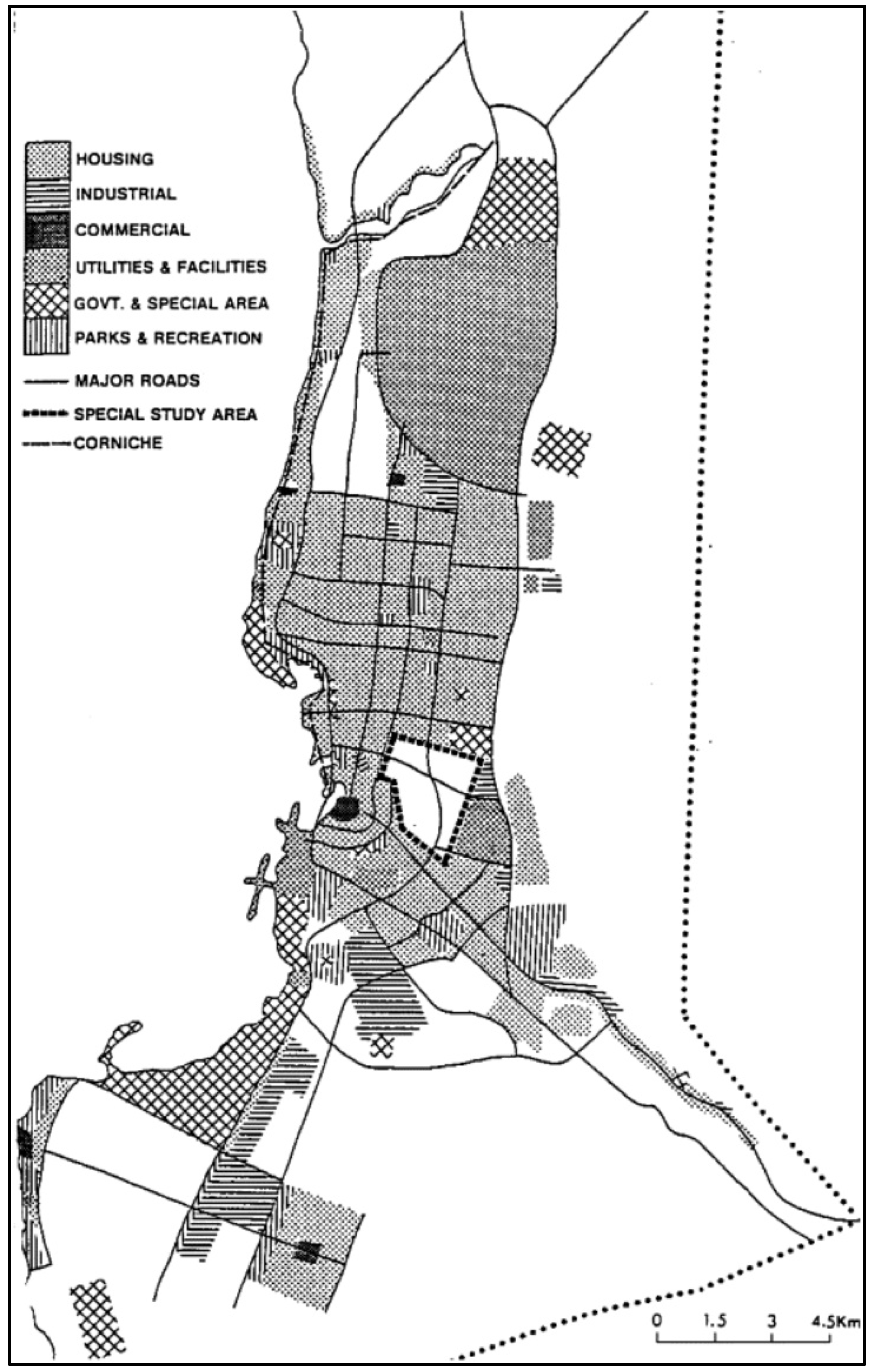
The first national development plan for the kingdom was issued in 1970. The plan not only discussed physical developments but also highlighted studies on, for example, population, transportation, regional planning, and socio-economic aspects. With the support of these studies, the second master plan for Jeddah was prepared in 1973 by an international consultancy consortium, Robert Matthew Johnson Marshall. The new Municipal System Act was approved in 1975, establishing the Ministry of Municipal and Rural Affairs (MOMRA). MOMRA started to fulfill its duty by reviewing previous master plans. The third master plan of Jeddah was announced in 1981 (Master Directive Plan). Prepared by Sert Jackson international consultants, the master plan focused on balancing the city’s urban growth and increasing and redistributing population density within the city, especially in the city center. The Sert Jackson master plan could be considered the first official efforts for regulating the city’s development [
43] (
Figure 1).
Despite MOMRA’s efforts to manage urban growth, Jeddah continued to expand. New infrastructure projects such as major roads and highways provided the necessary incentives for urban sprawl and the undesirable leapfrogging pattern of development [
44].
The urban planning authority realized the importance of adopting Urban Growth Boundary (UGB) studies to control and limit urban development in all major cities in Saudi Arabia. In response, the Saudi Council of Ministers ordered a two-year freeze on all urban expansion in the Kingdom in 1985. The main objective was to designate future phases of development every 10 years to limit the supply of land for residential development [
43].
Jeddah’s UGB study was started in 1985 and culminated in the announcement of the fourth master plan of the city in 1987. The fourth master plan was prepared by the Al-Soumat Engineering Services and (as requested by MOMRA) its main goal was to revise the previous Jeddah master plan and to prepare a comprehensive development plan that would guide the growth of the city until 2025 [
45]. The master plan encouraged the development in vacant land within the new urban growth boundary. In 1989, the Council of Ministers directed MOMRA to undertake the preparation of structural plans for Saudi cities to guide their long-term growth and approved the delineation of UGB for 100 Saudi urban centers, including Jeddah, for the next 50 years. The decision gives cities municipalities the right to not provide services to any residential subdivision that is located outside of its approved UGB [
44].
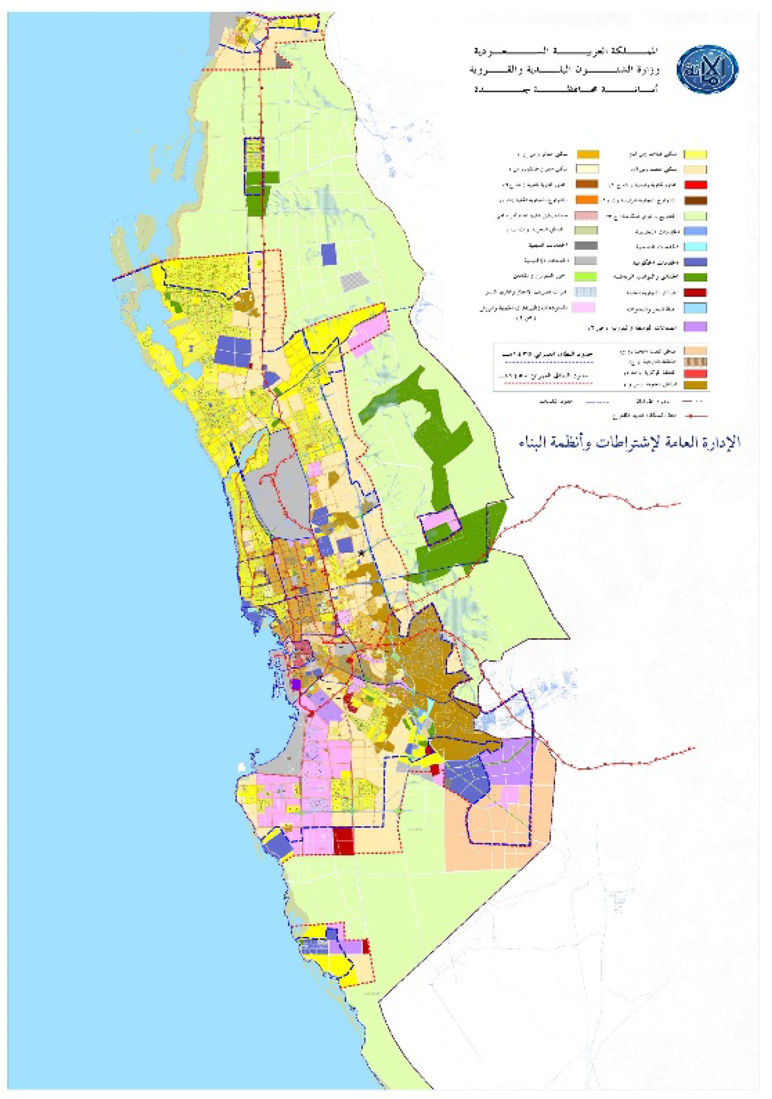
As a result of economic fluctuations and recessions experienced in the late 1980s and the subsequent effect of the Gulf War in the early 1990s, municipalities took advantage of the flexibility of the natural development process of the structure plan to redefine UGB to cover much larger areas. It took 17 years to finalize the new structure plan for Jeddah. In 2004, MOMRA announced Jeddah’s first metropolitan structure plan. The Al-Beeah consultancy office was appointed to prepare the structure plan for Jeddah Metropolitan and a detailed local plan to provide zoning regulations for selected areas at local level. The plan was mainly based on providing a broader spatial strategy for urban development until 2055 (
Figure 2).
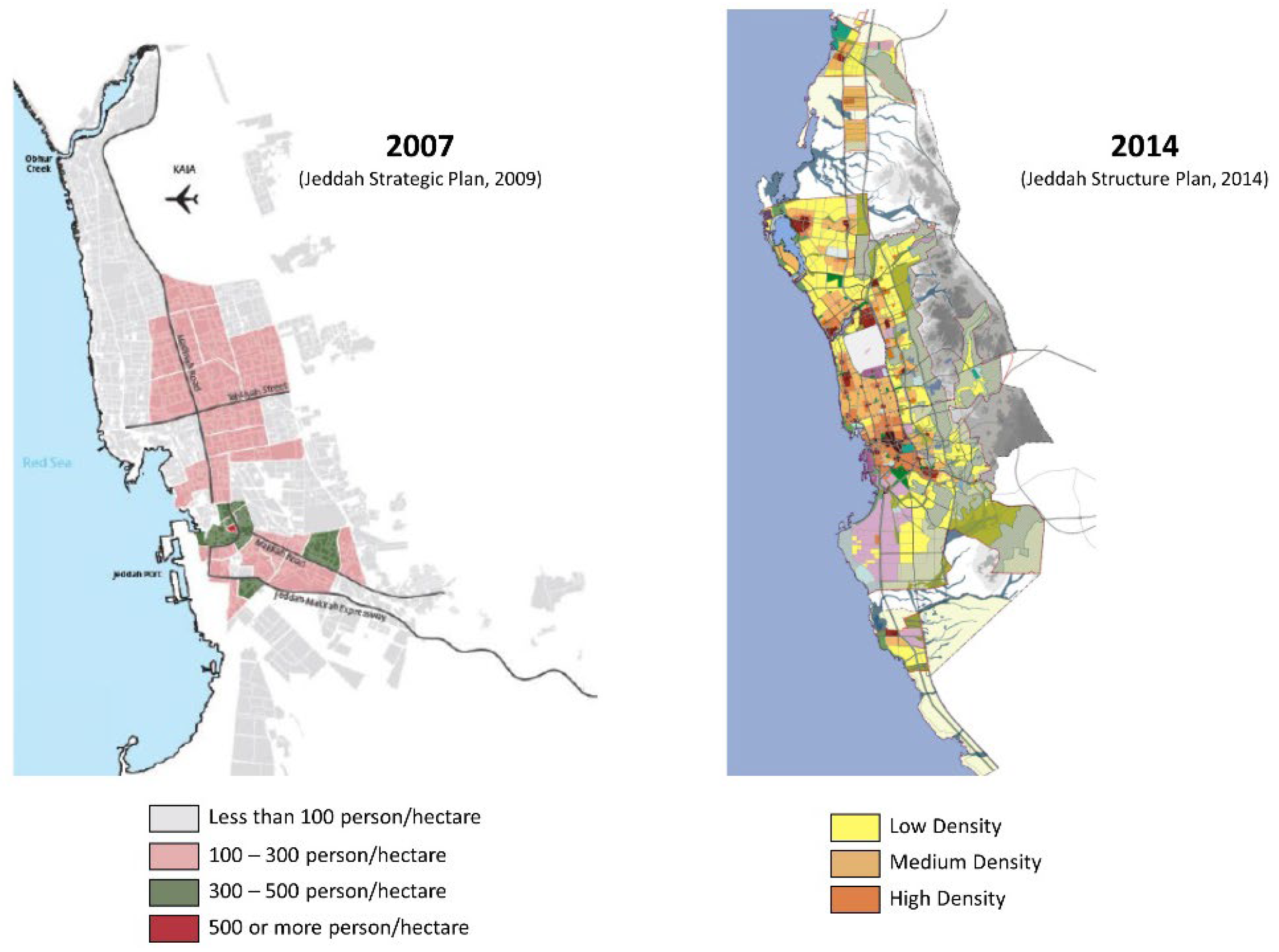
Jeddah’s 2004 structure plan could be considered unique for two reasons. First, it was the first structure plan for the city of Jeddah (Muhafazat Jeddah). The second factor is related to the local detail plan which attempted to utilize more fully vacant land within Jeddah’s UGB, and increase population density by increasing the height of existing multistory buildings in residential areas. The plan was to limit urban sprawl by defining the UGB and employing incentive policy to encourage urban fill.
Since 2004, the city of Jeddah has tried to restructure itself to cope with its huge urban area (176,500 ha). In 2007, Jeddah municipality announced a major management restructure and a new urban strategic plan for the city at the same time. The strategic plan focused on two pillars. The first was the redevelopment of unplanned urban districts, which account for 35% of the total urban area, and the second was to highlight the negative effects of urban sprawl on citizens’ quality of life and the limits of the municipality in controlling and providing residents with necessary services. As a result, the municipality of Jeddah announced the new city building regulations and controls policy in 2009, in which a compact city policy was mentioned for the first time. In 2014, Jeddah governance appointed AECOM’s engineering and consultancy office to update and develop Jeddah’s Metropolitan Structure Plan to increase the total area of the city to 741,400 ha.
3.2. Applying Compact City Model to Control Urban Sprawl in Jeddah
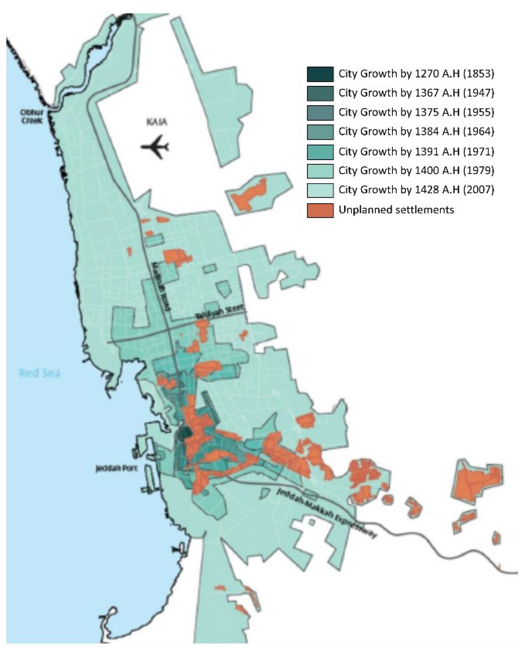
As a result of the tremendous urban growth witnessed in the city (
Figure 3), Jeddah Municipality began trying to establish an effective policy to help control the city’s exponential urban growth.
Jeddah’s urban sprawl, from the Municipality’s point of view, had many negative effects on the overall efficiency and performance of the city’s infrastructure. Perhaps the most significant effect is the inability of most governmental agencies responsible for providing public services and infrastructure (water supply, wastewater collection network, electricity, schools, and health services) to provide their services to most of the new urban areas which are normally located on the outskirts of the city. As a result, most of this sprawl appears in the north and east of the city. These new neighborhoods lacked services such as roads or water supply and a wastewater collection network, not to mention other services such as schools and basic health services (
Figure 4).
In parallel with Jeddah Municipality’s attempt to find a solution to the city’s sprawl problem, another problem arose at the national level. News of serious housing shortages in most of the Kingdom’s main cities became widespread. The Ministry of Housing pointed out that the shortage of suitable housing units was identified as one of the significant challenges facing the housing sector (Ministry of Housing, 2018). This shortage was attributable to many factors, most significantly high land cost and shortage of housing units [
46].
As a result of the limited supply of housing units and its inability to meet increasing demand, housing prices have increased dramatically for those who want to own and for tenants, especially within the urban boundaries of the main cities (Riyadh, Jeddah, Dammam). Many government reports have indicated that the real-estate market in the Kingdom needs 200,000 housing units annually, with a share for the city of Jeddah of about 20,000 units annually, whereas the market supply is, on average, 1500 units annually. Therefore, the directions from the Ministry of Municipal and Rural Affairs to local municipalities were designed to encourage them to develop and adopt new urban policies and reconsider the role that the municipalities can play in helping to solve the housing shortage.
In 2009, with the issuance of a new building regulations and urban controls policy document, it was announced that the new approach aims to manage urban expansion and sprawl, increase infrastructure efficiency, and improve the overall quality of life. Jeddah Municipality considered that the best solution lies in applying the compact city policy. Jeddah Municipality believes that amending and updating the old building regulations in some districts of the city and increasing population density in these districts from low to high densities will help increase the supply of housing units in the real-estate market, which should lead to a decrease in overall real-estate prices.
Jeddah Municipality announced the new update of the city building regulations and controls policy in 2009, through which the Municipality clarified its reliance on the compact city model (according to its point of view). The new regulations, as mentioned in the report of the Municipality, focused on an analysis of the current urban problems that the city suffers from, in addition to responding to the requests of citizens and the urgent planning issues in the city of Jeddah. The Municipality announced that the strategic foundations of the new policy and regulations are based on the desire to achieve sustainable urban development, controlling urban sprawl, and increasing population density in a manner that supports urban development and responds to the requirements of the residential and economic development of the city.
In a press conference to launch the new building regulations and controls policy document, the Department of Building Regulations in Jeddah Municipality (BRJM) confirmed that the most important goals of the policy lie in increasing the opportunities for real-estate investments through optimal use of lands within the city. Jeddah municipality expected that (according to BRJM) by implementing the new policy, the dependence on public transport and alternative means of transportation will increase, quality of urban design will be improved, and the needs of citizens, developers, and real-estate investors will be met.
The new policy and regulations document identified several goals and objectives:
Achieving sustainable urban development;
Controlling urban sprawl;
Increasing the population density in selective residential areas and on major commercial roads, to support urban development and meet the requirements of residential and economic development;
Increasing the efficiency of city zoning;
Increasing road network efficiency;
Increasing real-estate investment opportunities by encouraging the development of vacant lands within the city’s urban growth boundary;
Increasing the reliance on public transport;
Increasing the availability of car parking;
Adopting the principle of a Floor Area Ratio (FAR).
According to the scope of this paper, only the outcomes of applying the second objective will be discussed and analyzed.
4. Discussion
From everything mentioned above, it is clear that the importance of Jeddah and its dominance at both national and regional levels played an important role in making it an attractive urban center. However, the rapid urban growth was not supported by efficient urban administration. Since the launch of the first master plan for Jeddah in 1962, a high urban growth rate for the city was expected. The first master plan covered an area of 70,000 hectares, whereas the actual size of the city at that time did not exceed 2000 hectares, with the total number of inhabitants estimated to be 200,000 people.
Today, after 60 years, Jeddah’s structural plan covers a total area of 741,400 hectares, roughly 10 times the 1962 area. The expansion of the city in such a way and during a relatively short period reflects two major facts: first, the high rate of urban growth and expansion; second, the lack of efficient urban planning control tools and governance at both planning and management level.
As a developing country, the Kingdom of Saudi Arabia faced the problem of leapfrogging economics due to the volatility of the oil markets (the country’s main source of income), which was highly reflected in the urban and economic development in most major cities in the country. As a result, the main urban centers were growing and expanding, whether due to their attraction to local immigration from other less-developed regions or because of the volume of labor and foreign expertise that these cities needed to build their basic facilities and infrastructure at that time.
The Saudi government has passed through multiple stages of building and restructuring most of its sectors. The urban and city planning sector is no exception. Different governmental bodies and agencies were responsible for managing urban growth in the Kingdom through its early development stages.
The Ministry of Interior was the authority responsible for the first Jeddah plan in 1962, and then, from 1975, the responsibility was transferred to the Ministry of Municipal and Rural Affairs. Finally, the Emirate of Makkah Region (regional governor office) became the main body for managing the contract of the last structural plan for Jeddah in 2014, which was not officially approved until the date of preparing this study.
There was another urban planning governance issue. Different plans were prepared for the city in several stages. In the beginning, efforts were focused on producing local plans, and then there was a belief that such plans were not capable of responding to the rapid urban changes. Comprehensive plans were applied, followed by the structural plans for the flexibility that they could provide, taking into consideration the lack of local municipal resources needed for a city of that size.
With its limited financial resources, Jeddah Municipality tried at times to update and improve the city’s local plan. The city’s administrative boundary was changed in 2004 to cover an area of 741,400 hectares, according to the Jeddah Municipality website.
However, this was not the only problem encountered in trying to manage and control Jeddah’s urban growth. The central administration system and decision-making process followed in the Kingdom of Saudi Arabia reduced the effectiveness of coordination between all those governmental agencies responsible for providing services in the city. It is very challenging in such an administrative environment to coordinate and implement any comprehensive planning process. Each governmental agency has their own investment priorities and operation plan strategy which will affect the spatial development of the city differently.
As a result of all these interlocking challenges, the city of Jeddah has expanded sparsely and at the same time brings the percentage of vacant land areas within the urban area to 58% of the total city area, according to the Municipality’s 2009 report.
Therefore, Jeddah Municipality approached the compact city model to try to solve the urban sprawl problem and stimulate the redevelopment of vacant land within the city boundary. The Municipality believes that by applying the compact city model, the percentage of vacant lands within the urban boundary will decrease and the rate of sprawl development will slow down.
It is important to note that the study is not about evaluating the compact city model and its effectiveness in controlling urban sprawl, but is more about evaluating the compact city model adopted by Jeddah Municipality in 2009 to control urban sprawl and examine the extent of its success in achieving its objectives.
To answer this question, the study will discuss the topic from two main points of view. The first is an intellectual view and focuses on comparing the basic principles of the compact city model and that adopted by Jeddah Municipality to identify the differences between the two models. The second point of view is about studying the current situation in Jeddah after 12 years of implementing the policy by comparing two chosen criteria as follows:
4.1. Comparison between Compact City Policy and the Model Jeddah Municipality Applied
Compact city policies depend on three main pillars. First, encouraging people to live in high-density districts will reduce the rate of sprawl. The second concerns mixed-use development, through which mixed-use project areas are developed and help to reduce commuting times between home and work, noting that the theory even extends to the possibility of commuting by foot or bicycle. The third pillar is the availability and efficiency of public transportation, which is considered to be the backbone of the theory. It aims to reduce dependence on private vehicles and reduce daily commuting times.
The compact city theory was based on the desire to find solutions to the environmental, social, and economic problems of urban sprawl. Environmentally, this is achieved by reducing pollution resulting from reliance on private vehicles and long trips, in addition to the consumption of natural resources caused by urban sprawl encroaching on forests or agricultural areas on the outskirts of cities. Socially, it is achieved by reducing private plot size and increasing public spaces where people can meet regularly. The economic problems are mainly due to the high cost of providing infrastructure and social services to these outskirts’ neighborhoods.
Population densities: In the model applied by Jeddah Municipality, the new zoning and building regulations have succeeded in increasing the population densities in all the targeted neighborhoods (
Figure 5).
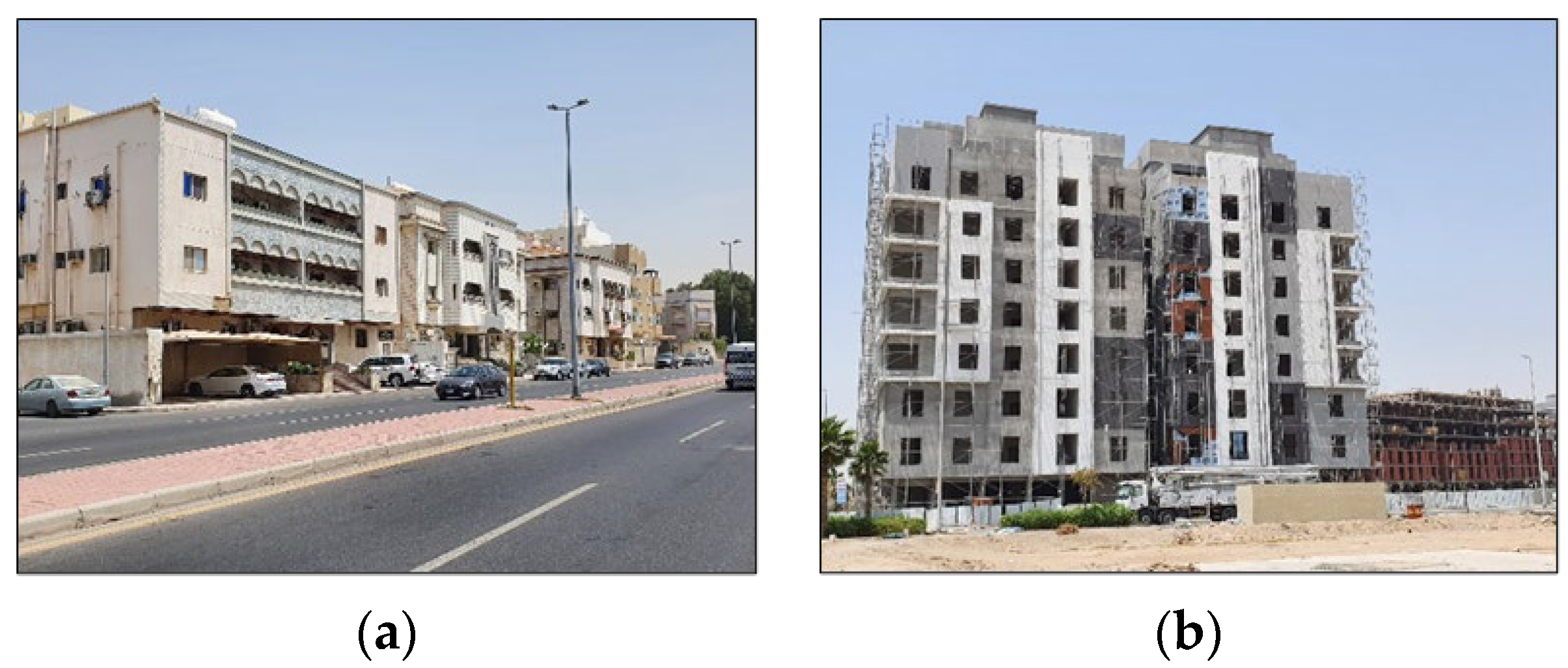
The new zoning regulation allowed the city to increase the number of floors for residential buildings from three to five (
Figure 6). As a result, residential buildings that used to contain a maximum of six residential units can now accommodate a minimum of nine units (it is possible to obtain twice this number by reducing the size of each unit).
High population densities have contributed to a noticeable increase in the effectiveness of the use of infrastructure in terms of number of users, but this was at the expense of the level and quality of services. Many neighborhoods experience frequent power outages during different periods of the year, especially summer. Many neighborhoods also witness sporadic problems regarding water supply (the system used in distributing water is not a continuous water supply system, but on the quota system, where water supplied according to a pre-scheduled time and for limited periods each week, which was greatly affected by the different densities and different rates of water consumption).
Another problem that arose because of the increased densities is the lack of sufficient parking spaces. The new policy implementation process does not consider the existing street size and parking demand within the targeted neighborhood (the original neighborhood design was developed to accommodate lower population density and less traffic than the new situation). As a result, residents start parking their vehicles randomly whenever there is an available space, which leads to decreased capacity of the internal streets and a lot of damage to street furniture (
Figure 7).
The new densification policy has led to many social problems. The most important is the lack of privacy. New buildings overlook the inner yard of the old ones, which leads to a lack of privacy for those buildings. New steel fencing starts appearing to provide privacy to the affected buildings (
Figure 8).
Mixed-use area: The announcement of the new policy was not aligned or supported by any strategic development plan to encourage the development of new mixed-use areas in Jeddah. Rather, the development of both commercial and office buildings has continued in the same regular striped pattern on the main roads. In fact, those areas where population densities have been modified became the least attractive to investments. Investments continued to flow where accessibility and services were available.
Public transportation: Despite the establishment of the first government public transport company in 2013, in Jeddah, there were no tangible actions on the ground. After announcing its public transportation master plan, the company faced a lot of financial difficulty which affected its ability to start the implementation phase, and construction works were also suspended. The performance of buses did not change and did not constitute any milestone in reducing reliance on private vehicles. Indeed, allowing women to drive for the first time in the Kingdom of Saudi Arabia put more pressure on road network performance and significantly increased car ownership.
4.2. Current Assessment
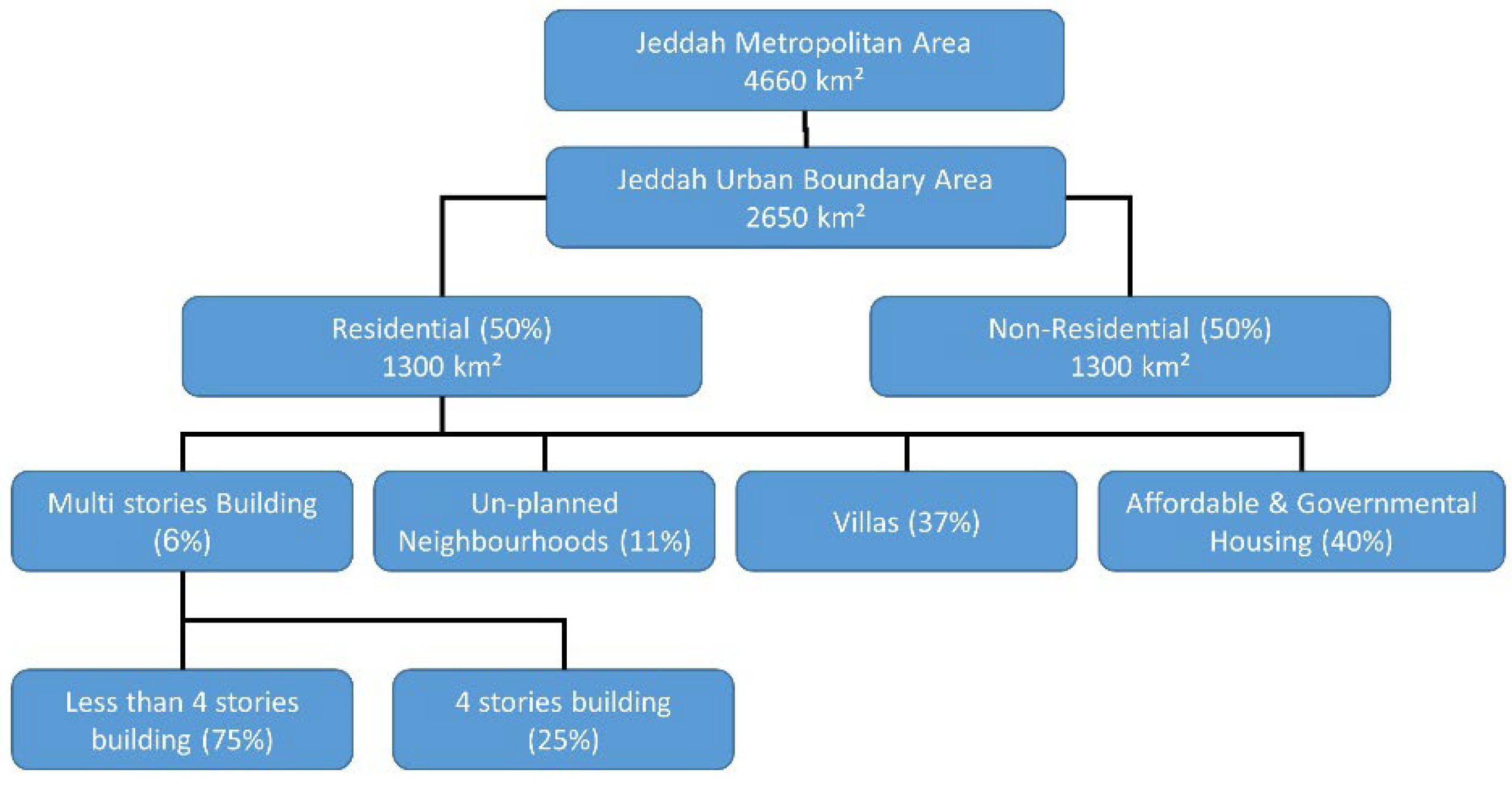
To complete the analysis and evaluation, this study reviewed one of the neighborhoods in which the building system has been modified and compared the current situation with the original design in terms of population density and traffic movement, parking, and infrastructure.
In 2009 (the announcement by Jeddah Municipality of the new city densification plan and building codes), the total urban area of Jeddah was 2650 square kilometers, of which the residential area is approximately 1300 square kilometers, which constitutes about 50% of the total area of the city. At that time, only 6% of these areas were designated for multistory buildings, as seen in
Figure 9.
The new building codes targeted 75% of these areas, according to a study prepared in 2009 by Jeddah Municipality.
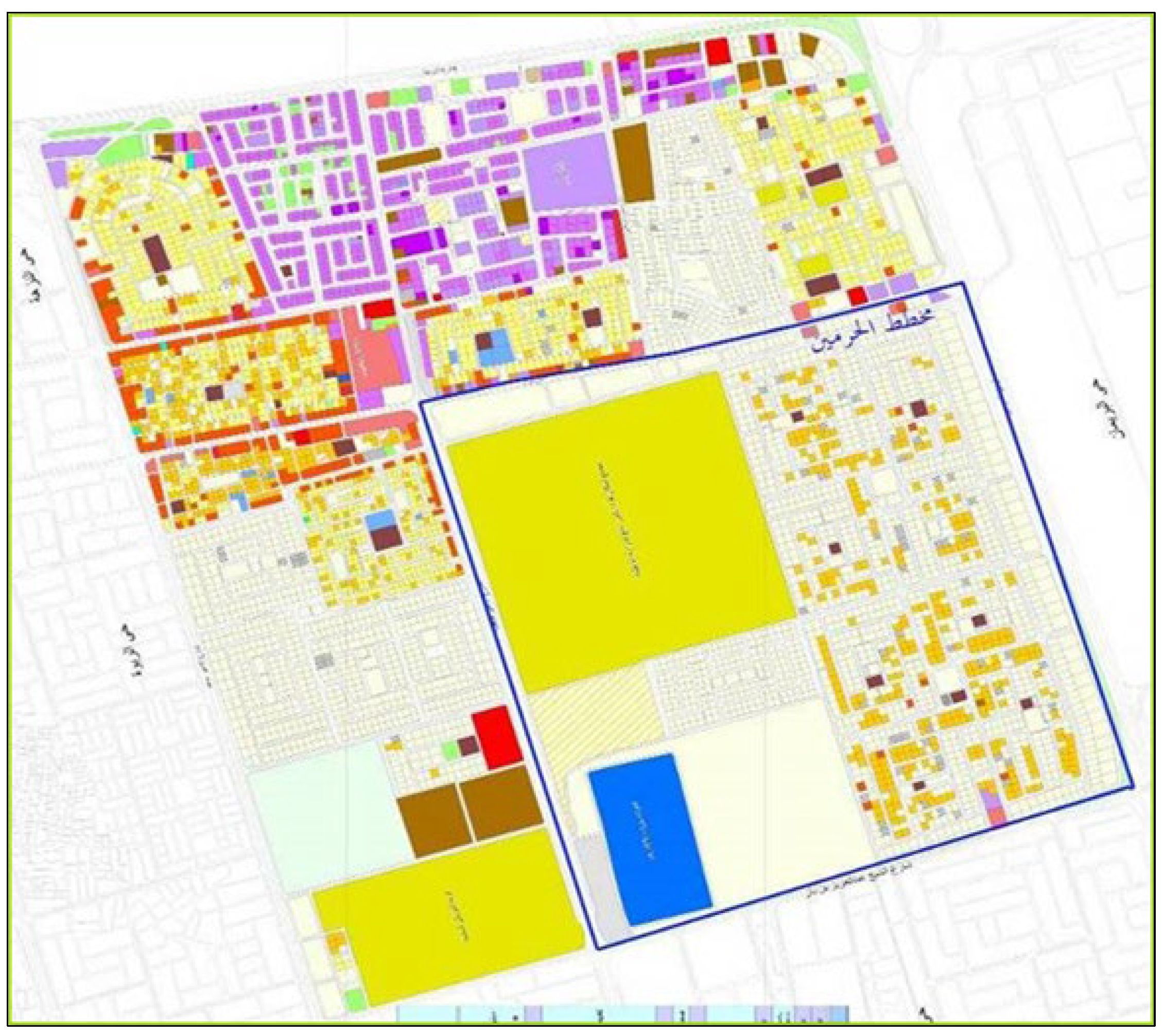
In most of these areas, the residential buildings comprised fewer than four stories. After applying the new codes, they became seven stories (a ground floor designated for car parking and four residential floors, with a roof villa consisting of two other floors). To study the impact of the new codes, Al-Marwah district was chosen as a case study.
The total area of Al-Marwah district is 1049 hectares, and the total population of the district is about 46,625 with an average density of 44 inhabitants per hectare (
Figure 10).
The old building codes stipulated two floors per building as a maximum.
Table 4 shows the effect of applying the new codes.
As a result of the densification policy implemented by the Municipality, population densities increased significantly in the affected neighborhoods and districts. The existing infrastructure networks were built to serve the original population density, which caused many problems such as frequent power cuts or an explosion of water pipes. The lack of sewage networks in these neighborhoods has exacerbated environmental problems and led to a rise in groundwater level in some areas to such an extent that they have become a dangerous to the structure of certain buildings.
An increase in population density in those neighborhoods also led to many social problems. Lack of privacy was the most important social issue, especially to those remaining units where owners did not want to redevelop according to the new codes.
Lack of car parking and road congestion have become the main characteristics of these districts. Most of these streets were originally designed narrow (less than 12 m); therefore, it is difficult for these streets to accommodate the additional traffic generated by the new population density.
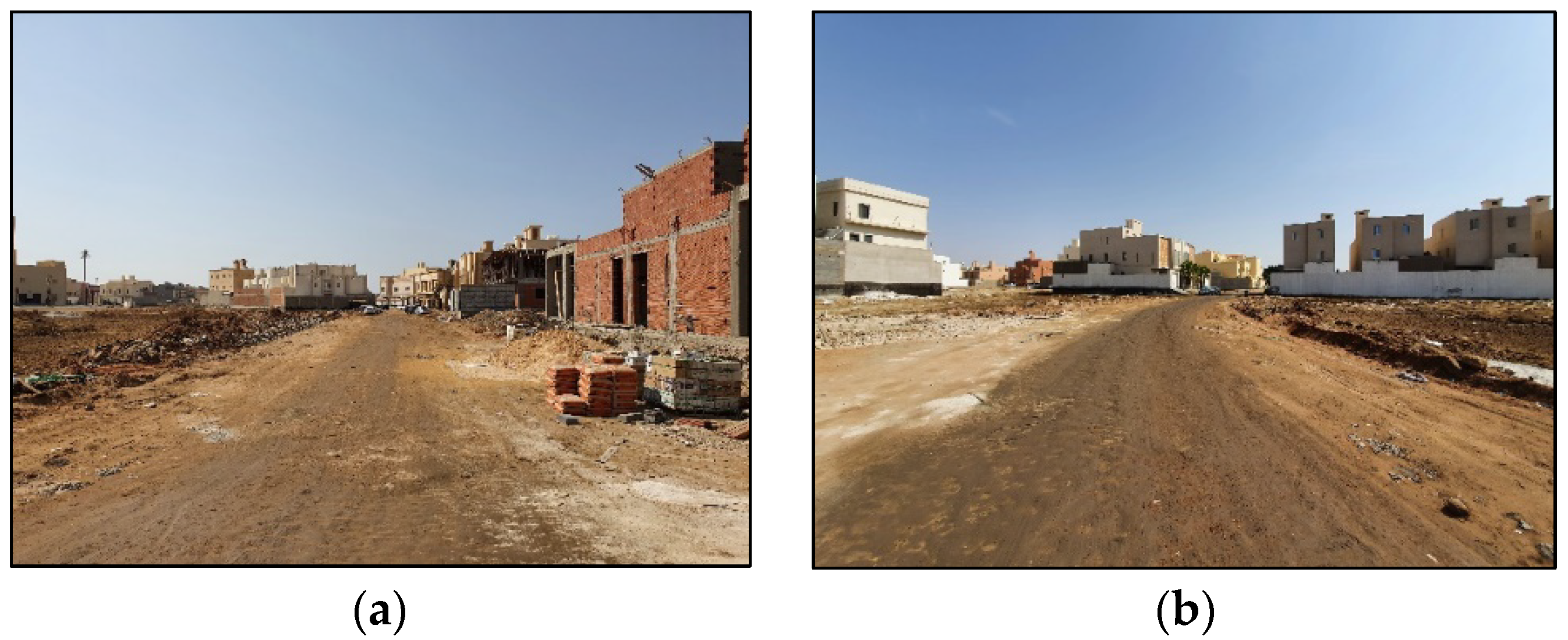
The main objective of applying the compact city model was to solve the urban sprawl problem and stimulate the redevelopment of vacant lands within the city boundary (as was clearly announced by the Municipality). In the absence of an accurate and integrated study that shows urban growth of the city annually or periodically, this research relies on aerial photographs to test the effect of the new policy in limiting urban growth on the outskirts of the city.
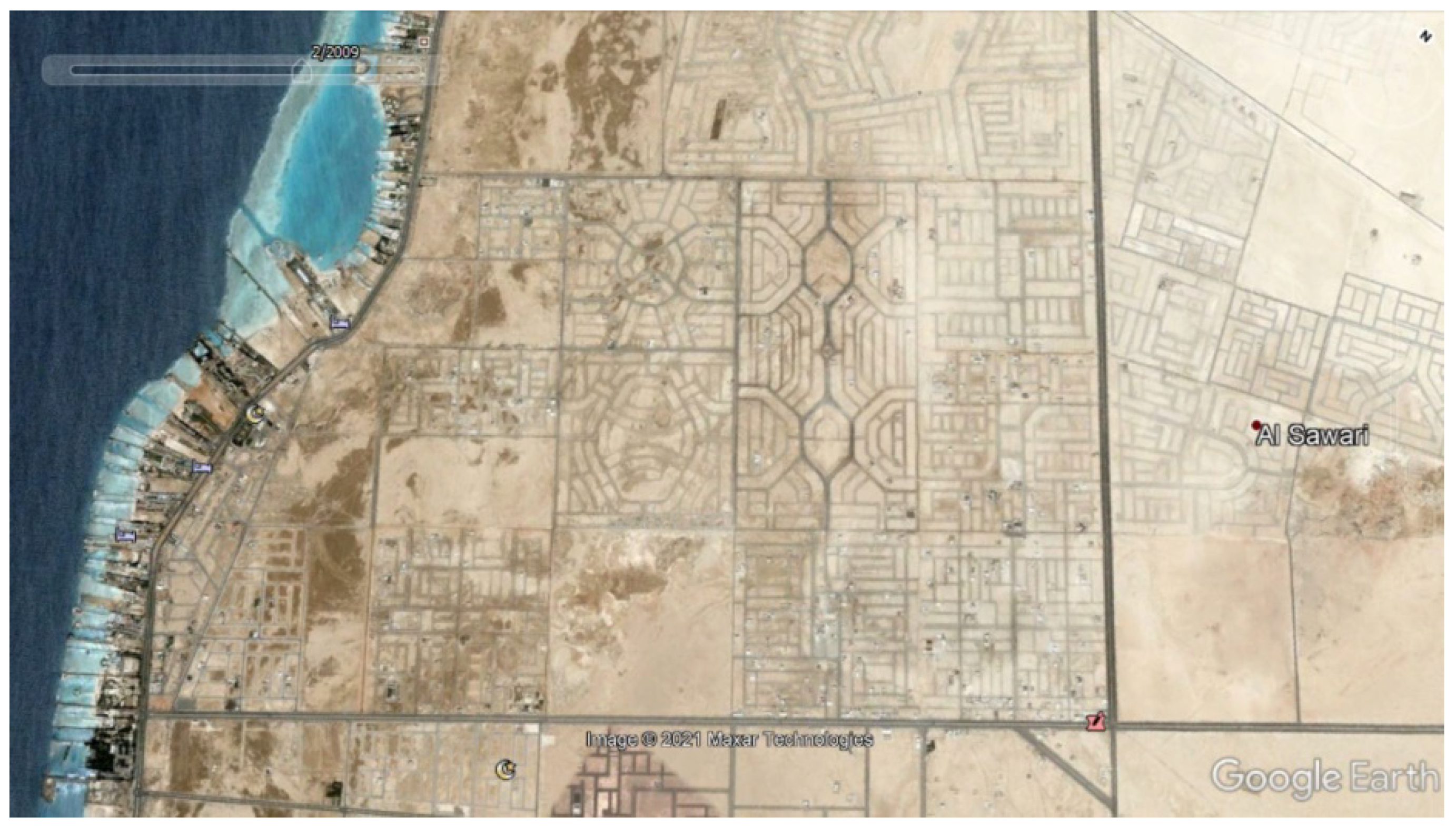
This research compares two aerial images for the north districts of Jeddah (the northernmost neighborhood in the city). It is assumed that, if the new policy was effective, these districts would be the first part of Jeddah to be affected. The area completely lacks most of the infrastructure networks and services (roads, water, sewerage, telephone) except for the electricity service, which is provided individually for each housing unit but not available throughout the whole district area.
The first aerial photo (
Figure 11) shows a district in north Jeddah back in 2009 (the year in which the new building policy was adopted). According to the comprehensive plan of Jeddah, the zoning regulation in these districts make them two-story residential villa zones (low-density area), and the average plot size in these districts ranges between 700 and 900 square meters per plot. In 2009, the whole district was empty and there was no development. The average price per square meter ranged from SAR 350 to SAR 500 per square meter (USD 95 to USD 135).
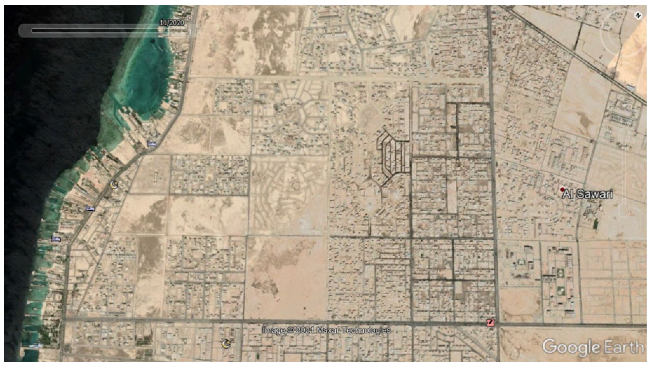
The second aerial photo (
Figure 12) shows the same area in 2021. It shows that 20% of the lands have been developed despite the lack of road and infrastructure (water and wastewater network) (In 2019 the government impose of value-added tax in the Kingdom (5%) for the first time in its history). It is important to highlight that, this development effected negatively by the imposing of the added value tax (5%) and the state of lockdown in 2020 because of COVID-19 crisis and later the increase in the value added tax rate to 15%.
The price of lands in those districts in 2021 ranges from SAR 1400 to 1600 per square meter (USD 380 to USD 485) with an increase of more than 300% of 2009 prices.
5. Conclusions
It has become clear that the process of achieving urban sustainability in the city of Jeddah by applying the compact city model and policy is not an easy task. Observations shows that there are some differences in the understanding of the overall compact city concept, and different perceptions of how such policies could be implemented. This disappointing result is not surprising, considering the highly varied social and economic characteristics of the population in Jeddah, on the one hand, and the formal centralized planning process and decision making, on the other.
To achieve noticeable sustainable urban development for a city such as Jeddah, the Municipality should have different policies that target flat urban development regulation to promote a more realistic and sustainable intensification process. A well-designed oriented approach to guide the future development providing functional open spaces to enhance the sense of community, reduce automobile dependency, and respect all local social, economic, and environmental aspects is an important consideration.
It appears to be more logical to rely on a consolidation process to achieve sustainable urban development in Jeddah. Jeddah has dispersed and sprawled development at a much faster rate than most other cities in the region. To respond to this, policymakers and urban planners should focus on the process of urban consolidation as part of a comprehensive package of urban planning framework strategies to achieve more sustainable multidisciplinary goals. The consolidation process should consider medium and high-density housing projects, building on current vacant lands, and encouraging new mixed-use development and mixed housing types such as townhouses, apartments, and terraced housing or any other housing type that could satisfy local social and economic needs.
It is important to focus on sustainable local urban community design parameters which will help create more human-scale urban developments and environmentally friendly communities that support and reflect local social parameters rather than just focusing on population density and land development assumptions.
It is impossible to transform the urban form and structure of an existing city overnight. In Jeddah, compact city policies were quickly developed and implemented, and as a result, many social, economic, and environmental problems arose. It led in some cases to increased cost of infrastructure development and maintenance. The central urban planning authority (MOMRA) started to become skeptical about the benefits of the whole compact city model implementation, feasibility, and sustainability.
Saudi city planning authorities need to address urban sprawl in a way that reflects local conditions and needs (economically, socially, environmentally, etc.) as a long-term solution for the future development of Jeddah. The study shows that compact city model characteristics somehow demand a radical shift in Saudi’s current urban and social culture, requiring careful comprehensive studies and a careful implementation process.


