
Generation of Potential Sites for Sustainable Water Harvesting Techniques in Oum Zessar Watershed, South East Tunisia


 , , , and
Abstract
:1. Introduction
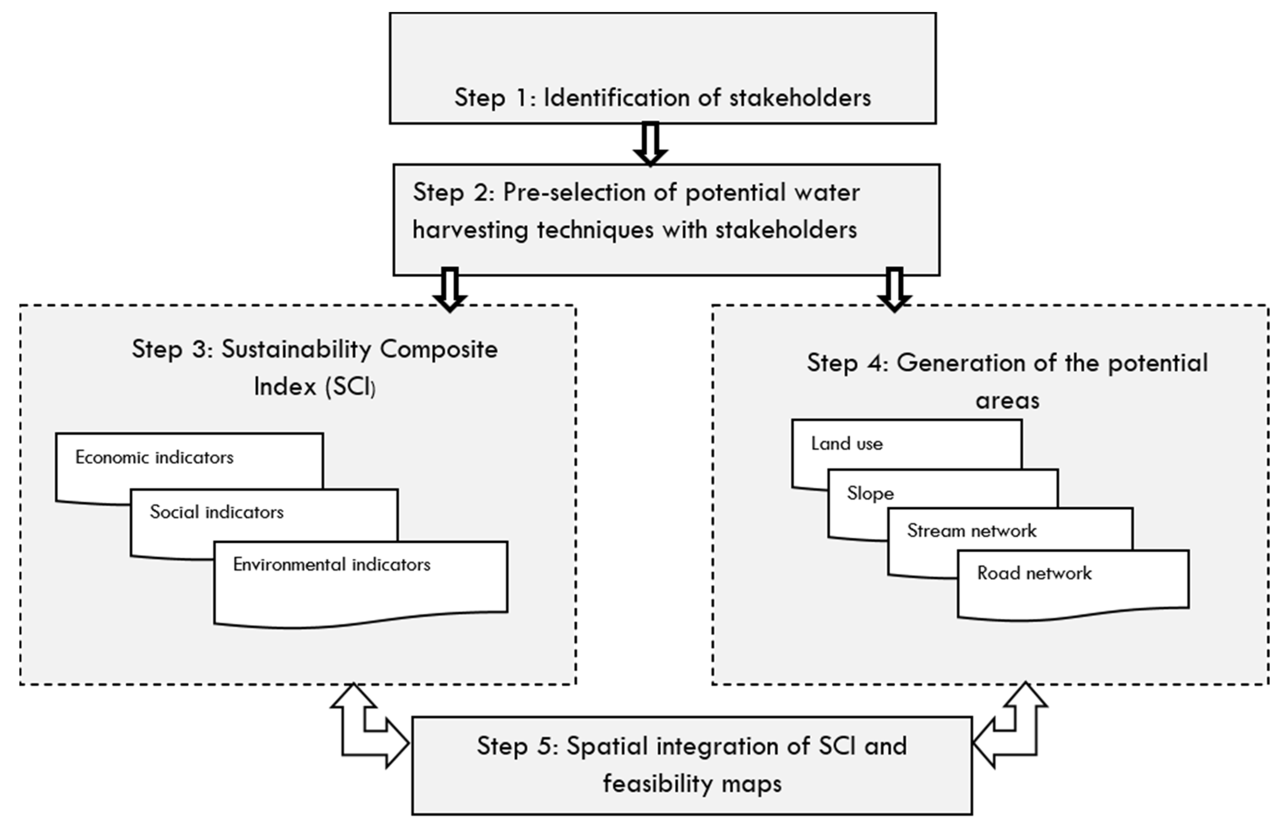
2. Materials and Methods
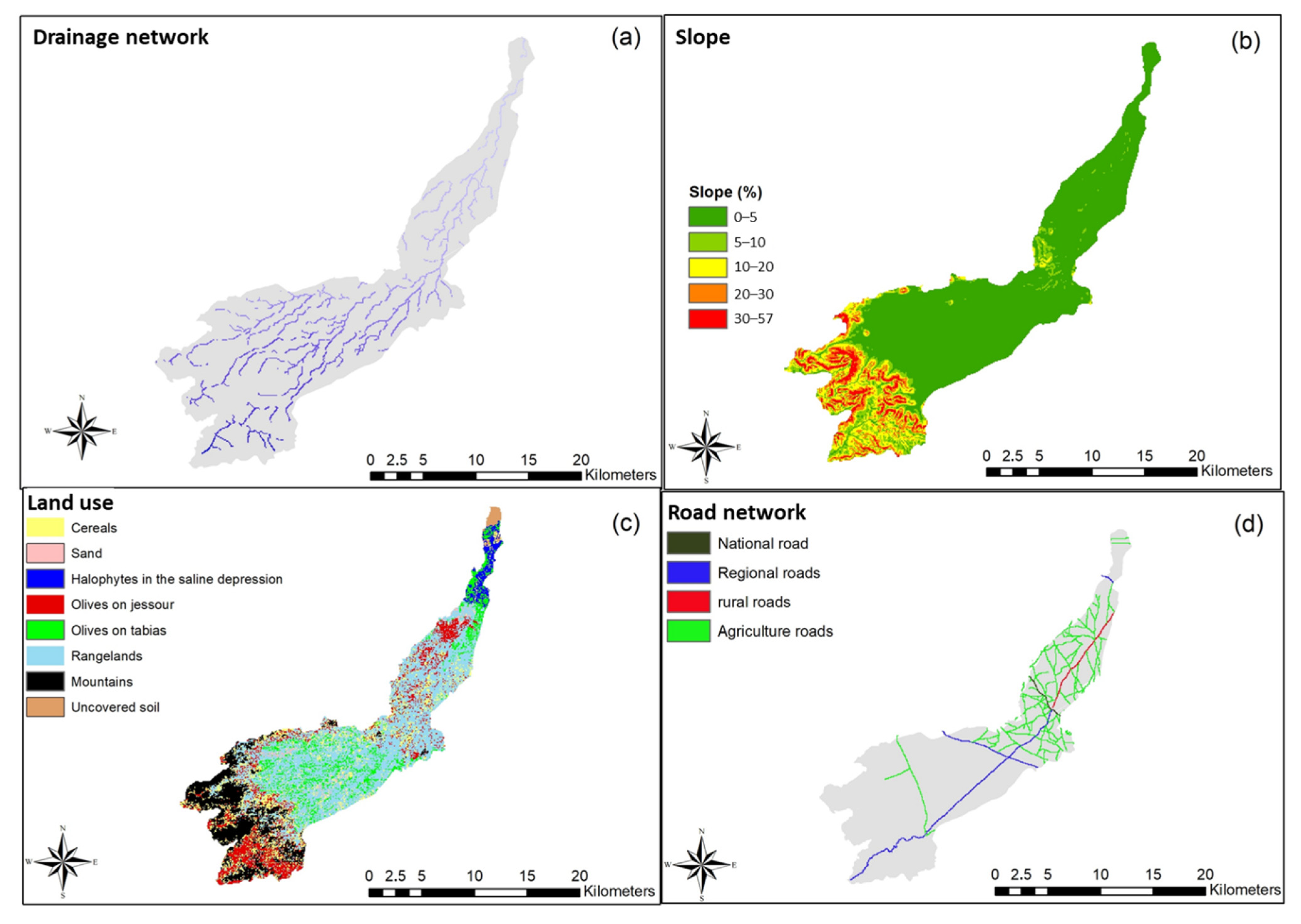
2.1. Study Area
2.2. Method
- Step 1:
- Identification of stakeholders
- Step 2:
- Pre-selection of potential water harvesting techniques
- Step 3:
- Calculation and interpolation of the sustainability index (SI)
- Step 4:
- Identification of potential area based on biophysical criteria
- Step 5:
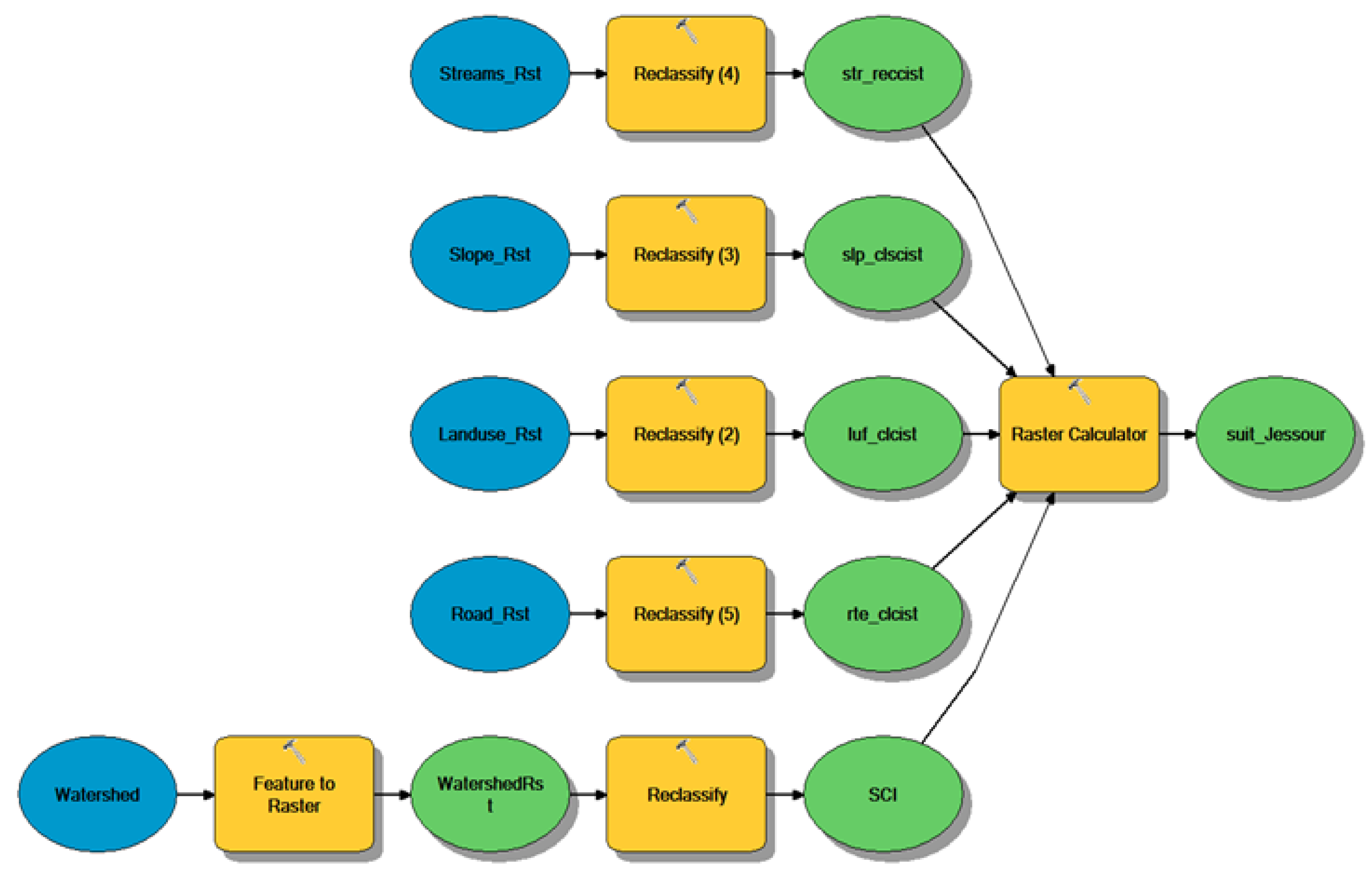
- Generation of suitability maps; spatial integration of SI and biophysical layers
3. Results
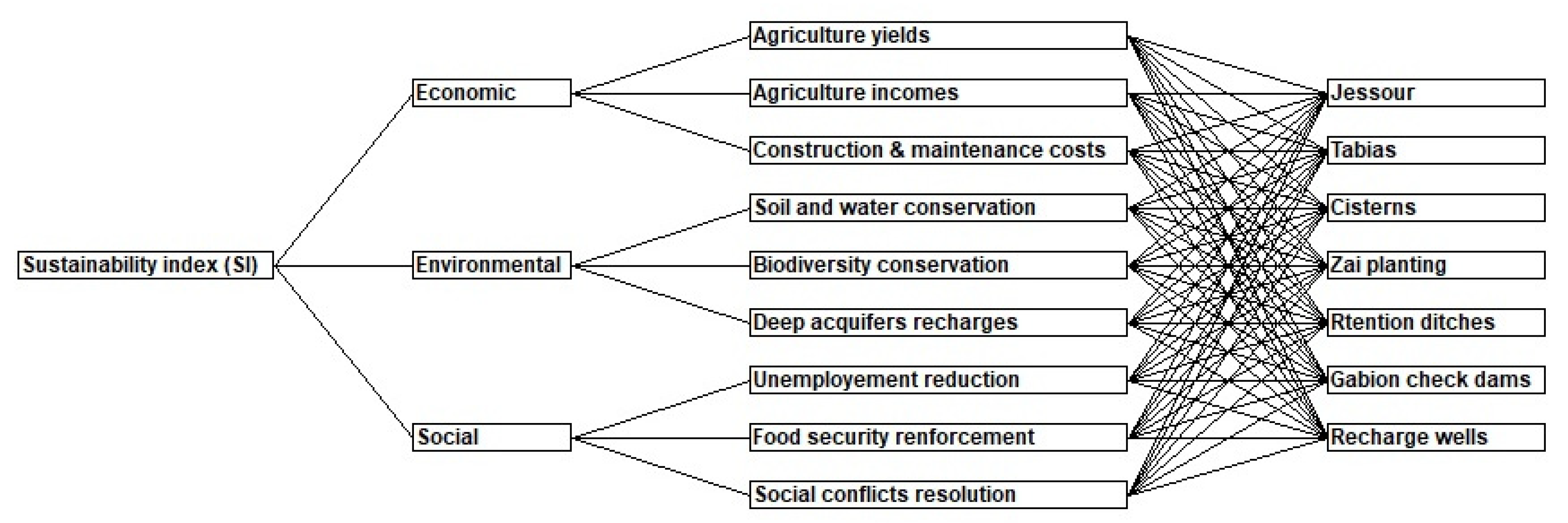
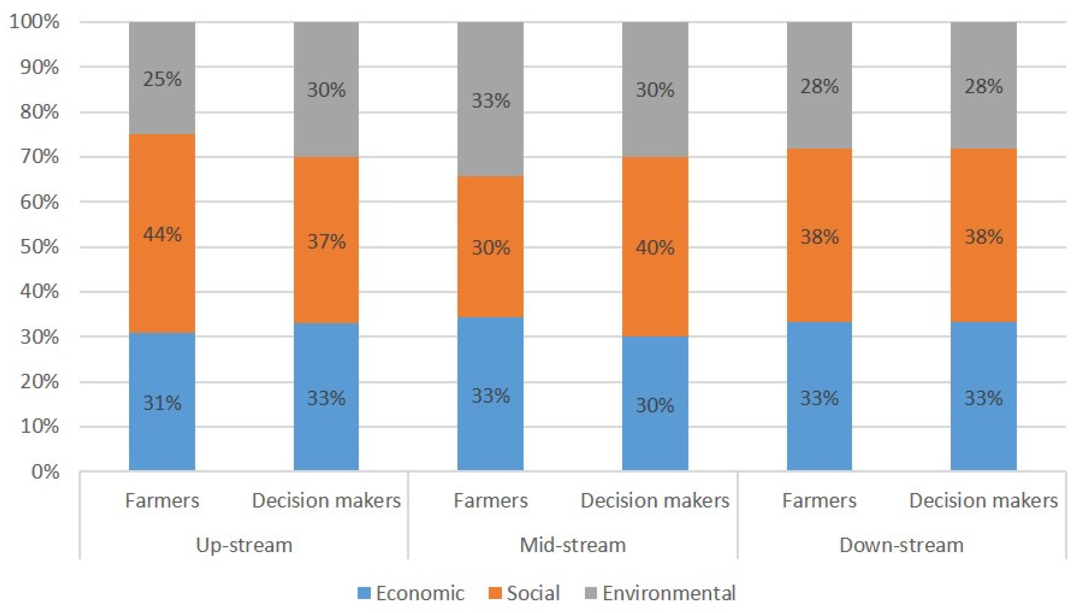
3.1. Sustainability of WHTs
3.2. Suitable Sites for WHTs
4. Discussion
5. Conclusions
Author Contributions
Funding
Institutional Review Board Statement
Informed Consent Statement
Data Availability Statement
Acknowledgments
Conflicts of Interest
References
- Ali, S.; Zhang, S.; Yue, T. Environmental and economic assessment of rainwater harvesting systems under five climatic conditions of Pakistan. J. Clean. Prod. 2020, 259, 120829. [Google Scholar] [CrossRef]
- Zhang, S.; Zhang, J.; Yue, T.; Jing, X. Impacts of climate change on urban rainwater harvesting systems. Sci. Total Environ. 2019, 665, 262–274. [Google Scholar] [CrossRef] [PubMed]
- Kahil, M.T.; Dinar, A.; Albiac, J. Modeling water scarcity and droughts for policy adaptation to climate change in arid and semiarid regions. J. Hydrol. 2015, 522, 95–109. [Google Scholar] [CrossRef] [Green Version]
- Kourtis, I.M.; Kotsifakis, K.G.; Feloni, E.G.; Baltas, E.A. Sustainable water resources management in small greek islands under changing climate. Water 2019, 11, 1694. [Google Scholar] [CrossRef] [Green Version]
- Markowska, J.; Szalińska, W.; Dąbrowska, J.; Brząkała, M. The concept of a participatory approach to water management on a reservoir in response to wicked problems. J. Environ. Manag. 2020, 259, 109626. [Google Scholar] [CrossRef] [PubMed]
- Ruso, M.; Akintuǧ, B.; Kentel, E. Optimum tank size for a rainwater harvesting system: Case study for Northern Cyprus. In Proceedings of the IOP Conference Series: Earth and Environmental Science, Helsinki, Finland, 22–24 May 2019. [Google Scholar]
- Haider, H.; Ghumman, A.R.; Al-Salamah, I.S.; Ghazaw, Y.; Abdel-Maguid, R.H. Sustainability Evaluation of Rainwater Harvesting-Based Flood Risk Management Strategies: A Multilevel Decision-Making Framework for Arid Environments. Arab. J. Sci. Eng. 2019, 44, 8465–8488. [Google Scholar] [CrossRef]
- Torres, M.N.; Fontecha, J.E.; Zhu, Z.; Walteros, J.L.; Rodríguez, J.P. A participatory approach based on stochastic optimization for the spatial allocation of Sustainable Urban Drainage Systems for rainwater harvesting. Environ. Model. Softw. 2020, 123, 104532. [Google Scholar] [CrossRef]
- Sayl, K.N.; Mohammed, A.S.; Ahmed, A.D. GIS-based approach for rainwater harvesting site selection. In IOP Conference Series: Materials Science and Engineering; IOP Publishing: Bristol, UK, 2020; Volume 737, p. 012246. [Google Scholar]
- Lozano, R. Envisioning sustainability three-dimensionally. J. Clean. Prod. 2008, 16, 1838–1846. [Google Scholar] [CrossRef]
- Lasage, R.; Verburg, P.H. Evaluation of small scale water harvesting techniques for semi-arid environments. J. Arid Environ. 2015, 118, 48–57. [Google Scholar] [CrossRef]
- Pachpute, J.S.; Tumbo, S.D.; Sally, H.; Mul, M.L. Sustainability of rainwater harvesting systems in rural catchment of Sub-Saharan Africa. Water Resour. Manag. 2009, 23, 2815–2839. [Google Scholar] [CrossRef]
- Díaz-Pereira, E.; Asunción Romero-Díaz, M.; de Vente, J. Environmental and socioeconomic benefits and limitations of water harvesting techniques in semiarid regions. In Proceedings of the EGU General Assembly Conference Abstracts, Vienna, Austria, 17–22 April 2016; p. EPSC2016-13505. [Google Scholar]
- Singto, C.; Fleskens, L.; Vos, J.; Quinn, C. Applying Bayesian belief networks (BBNs) with stakeholders to explore and codesign options for water resource interventions. Sustain. Water Resour. Manag. 2020, 6, 23. [Google Scholar] [CrossRef] [Green Version]
- Vohland, K.; Barry, B. A review of in situ rainwater harvesting (RWH) practices modifying landscape functions in African drylands. Agric. Ecosyst. Environ. 2009, 131, 119–127. [Google Scholar] [CrossRef]
- Ghimire, S.R.; Johnston, J.M. Sustainability assessment of agricultural rainwater harvesting: Evaluation of alternative crop types and irrigation practices. PLoS ONE 2019, 14, e0216452. [Google Scholar] [CrossRef] [PubMed]
- Moy, W.S.; Cohon, J.L.; ReVelle, C.S. A programming model for analysis of the reliability, resilience, and vulnerability of a water supply reservoir. Water Resour. Res. 1986, 22, 489–498. [Google Scholar] [CrossRef]
- Kundzewicz, Z.W.; Kindler, J. Multiple criteria for evaluation of reliability aspects of water resource systems. IAHS Publ. Ser. Proc. Rep. Intern. Assoc. Hydrol. Sci. 1995, 231, 217–224. [Google Scholar]
- Asefa, T.; Adams, A.; Kajtezovic-Blankenship, I. A tale of integrated regional water supply planning: Meshing socio-economic, policy, governance, and sustainability desires together. J. Hydrol. 2014, 519, 2632–2641. [Google Scholar] [CrossRef]
- Park, D.; Um, M.-J. Sustainability index evaluation of the rainwater harvesting system in six US urban cities. Sustainability 2018, 10, 280. [Google Scholar] [CrossRef] [Green Version]
- Biazin, B.; Sterk, G.; Temesgen, M.; Abdulkedir, A.; Stroosnijder, L. Rainwater harvesting and management in rainfed agricultural systems in sub-Saharan Africa—A review. Phys. Chem. Earth 2012, 47–48, 139–151. [Google Scholar] [CrossRef]
- Boelee, E.; Yohannes, M.; Poda, J.N.; McCartney, M.; Cecchi, P.; Kibret, S.; Hagos, F.; Laamrani, H. Options for water storage and rainwater harvesting to improve health and resilience against climate change in Africa. Reg. Environ. Chang. 2013, 13, 509–519. [Google Scholar] [CrossRef]
- Dile, Y.T.; Rockström, J.; Karlberg, L. Suitability of Water Harvesting in the Upper Blue Nile Basin, Ethiopia: A First Step towards a Mesoscale Hydrological Modeling Framework. Adv. Meteorol. 2016, 2016, 5935430. [Google Scholar] [CrossRef] [Green Version]
- Al-Adamat, R.; Diabat, A.; Shatnawi, G. Combining GIS with multicriteria decision making for siting water harvesting ponds in Northern Jordan. J. Arid Environ. 2010, 74, 1471–1477. [Google Scholar] [CrossRef]
- Chenini, I.; Mammou, A.B.; El May, M. Groundwater recharge zone mapping using GIS-based multi-criteria analysis: A case study in Central Tunisia (Maknassy Basin). Water Resour. Manag. 2010, 24, 921–939. [Google Scholar] [CrossRef]
- Mahmoud, S.H.; Alazba, A.A.; Adamowski, J.; El-Gindy, A.M. GIS methods for sustainable stormwater harvesting and storage using remote sensing for land cover data—Location assessment. Environ. Monit. Assess. 2015, 187, 598. [Google Scholar] [CrossRef] [PubMed]
- Adham, A.; Sayl, K.N.; Abed, R.; Abdeladhim, M.A.; Wesseling, J.G.; Riksen, M.; Fleskens, L.; Karim, U.; Ritsema, C.J. A GIS-based approach for identifying potential sites for harvesting rainwater in the Western Desert of Iraq. Int. Soil Water Conserv. Res. 2018, 6, 297–304. [Google Scholar] [CrossRef]
- Ibrahim, G.R.F.; Rasul, A.; Hamid, A.A.; Ali, Z.F.; Dewana, A.A. Suitable site selection for rainwater harvesting and storage case study using Dohuk governorate. Water 2019, 11, 864. [Google Scholar] [CrossRef] [Green Version]
- Shadeed, S.; Judeh, T.; Riksen, M. Rainwater harvesting for sustainable agriculture in high water-poor areas in the West Bank, Palestine. Water 2020, 12, 380. [Google Scholar] [CrossRef] [Green Version]
- Al-Abadi, A.M.; Shahid, S.; Ghalib, H.B.; Handhal, A.M. A GIS-Based Integrated Fuzzy Logic and Analytic Hierarchy Process Model for Assessing Water-Harvesting Zones in Northeastern Maysan Governorate, Iraq. Arab. J. Sci. Eng. 2017, 42, 2487–2499. [Google Scholar] [CrossRef]
- Shadmehri Toosi, A.; Ghasemi Tousi, E.; Ghassemi, S.A.; Cheshomi, A.; Alaghmand, S. A multi-criteria decision analysis approach towards efficient rainwater harvesting. J. Hydrol. 2020, 582, 124501. [Google Scholar] [CrossRef]
- Wu, R.S.; Molina, G.L.L.; Hussain, F. Optimal Sites Identification for Rainwater Harvesting in Northeastern Guatemala by Analytical Hierarchy Process. Water Resour. Manag. 2018, 32, 4139–4153. [Google Scholar] [CrossRef] [Green Version]
- Grum, B.; Hessel, R.; Kessler, A.; Woldearegay, K.; Yazew, E.; Ritsema, C.; Geissen, V. A decision support approach for the selection and implementation of water harvesting techniques in arid and semi-arid regions. Agric. Water Manag. 2016, 173, 35–47. [Google Scholar] [CrossRef]
- Adham, A.; Wesseling, J.G.; Riksen, M.; Ouessar, M.; Ritsema, C.J. A water harvesting model for optimizing rainwater harvesting in the wadi Oum Zessar watershed, Tunisia. Agric. Water Manag. 2016, 176, 191–202. [Google Scholar] [CrossRef]
- Adham, A.; Wesseling, J.G.; Abed, R.; Riksen, M.; Ouessar, M.; Ritsema, C.J. Assessing the impact of climate change on rainwater harvesting in the Oum Zessar watershed in Southeastern Tunisia. Agric. Water Manag. 2019, 221, 131–140. [Google Scholar] [CrossRef]
- Reinhardt, J.; Liersch, S.; Abdeladhim, M.A.; Diallo, M.; Dickens, C.; Fournet, S.; Hattermann, F.F.; Kabaseke, C.; Muhumuza, M.; Mul, M.L.; et al. Systematic evaluation of scenario assessments supporting sustainable integrated natural resources management: Evidence from four case studies in Africa. Ecol. Soc. 2018, 23, 5. [Google Scholar] [CrossRef] [Green Version]
- Ouessar, M. Hydrological Impacts of Rainwater Harvesting in Wadi Oum Zessar Watershed (Southern Tunisia); Ghent University: Ghent, Belgium, 2007. [Google Scholar]
- König, H.J.; Sghaier, M.; Schuler, J.; Abdeladhim, M.; Helming, K.; Tonneau, J.P.; Ounalli, N.; Imbernon, J.; Morris, J.; Wiggering, H. Participatory impact assessment of soil and water conservation scenarios in Oum Zessar watershed, Tunisia. Environ. Manag. 2012, 50, 153–165. [Google Scholar] [CrossRef] [PubMed]
- Jarray, H.; Zammouri, M.; Ouessar, M.; Hamzaoui-Azaza, F.; Barbieri, M.; Zerrim, A.; Soler, A.; Yahyaoui, H. Groundwater vulnerability based on GIS approach: Case study of Zeuss-Koutine aquifer, South-Eastern Tunisia. Geofísica Int. 2017, 56, 157–172. [Google Scholar] [CrossRef]
- Sghaier, M.; Arbi, A.M.; Tonneau, J.-P.; Ounalli, N.; Jeder, H.; Bonin, M. Land degradation in the arid Jeffara Region, Tunisia. In Land Use Policies for Sustainable Development; Edward Elgar Publishing: Cheltenham, UK, 2012. [Google Scholar]
- Ouessar, M.; Hessel, R.; Kirkby, M.; Sghaier, M.; Ritsema, C. D1.4 Report on the Assessment of Potential of Water Harvesting; WAHARA Report Number 10; Wageningen University: Wageningen, The Netherlands, 2013. [Google Scholar]
- Arbi, A.; Ouessar, M.; Sghaier, M. Procedure of Water Harvesting Technologies Evaluation and Selection. Oum Zessar Watershed Tunisia Case Study; WAHARA Report Number 14; Scientific Reports Series; Wageningen University: Wageningen, The Netherlands, 2013. [Google Scholar]
- Okpara, U.T.; Fleskens, L.; Stringer, L.C.; Hessel, R.; Bachmann, F.; Daliakopoulos, I.; Berglund, K.; Blanco Velazquez, F.J.; Ferro, N.D.; Keizer, J.; et al. Helping stakeholders select and apply appraisal tools to mitigate soil threats: Researchers’ experiences from across Europe. J. Environ. Manag. 2020, 257, 110005. [Google Scholar] [CrossRef]
- Prell, C.; Hubacek, K.; Reed, M. Stakeholder analysis and social network analysis in natural resource management. Soc. Nat. Resour. 2016, 22, 367–383. [Google Scholar] [CrossRef]
- Curșeu, P.L.; Schruijer, S.G. Stakeholder diversity and the comprehensiveness of sustainability decisions: The role of collaboration and conflict. Curr. Opin. Environ. Sustain. 2017, 28, 114–120. [Google Scholar] [CrossRef]
- Harrison, S.R.; Qureshi, M.E. Choice of stakeholder groups and members in multicriteria decision models. Nat. Res. Forum 2000, 24, 11–19. [Google Scholar] [CrossRef]
- Calianno, M.; Fallot, J.-M.; Ben Fraj, T.; Ben Ouezdou, H.; Reynard, E.; Milano, M.; Abbassi, M.; Ghram Messedi, A.; Adatte, T. Benefits of Water-Harvesting Systems (Jessour) on Soil Water Retention in Southeast Tunisia. Water 2020, 12, 295. [Google Scholar] [CrossRef] [Green Version]
- Ben Zaied, M.; Jomaa, S.; Ouessar, M. Soil Erosion Estimates in Arid Region: A Case Study of the Koutine Catchment, Southeastern Tunisia. Appl. Sci. 2021, 11, 6763. [Google Scholar] [CrossRef]
- Moussa, B.M.; Diouf, A.; Abdourahamane, S.I.; Axelsen, J.A.; Ambouta, K.J.; Mahamane, A. Combined traditional water harvesting (Zaï) and mulching techniques increase available Soil phosphorus content and millet yield. J. Agric. Sci. 2016, 8, 126. [Google Scholar] [CrossRef]
- Critchley, W.; Reij, C.; Willcocks, T. Indigenous soil and water conservation: A review of the state of knowledge and prospects for building on traditions. Land Degrad. Dev. 1994, 5, 293–314. [Google Scholar] [CrossRef]
- Konidari, P.; Mavrakis, D. A multi-criteria evaluation method for climate change mitigation policy instruments. Energy Policy 2007, 35, 6235–6257. [Google Scholar] [CrossRef]
- Danielson, M.; Ekenberg, L. The CAR method for using preference strength in multi-criteria decision making. Group Decis. Negot. 2016, 25, 775–797. [Google Scholar] [CrossRef] [Green Version]
- Lavik, M.S.; Hardaker, J.B.; Lien, G.; Berge, T.W. A multi-attribute decision analysis of pest management strategies for Norwegian crop farmers. Agric. Syst. 2020, 178, 102741. [Google Scholar] [CrossRef]
- Jafari Shalamzari, M.; Zhang, W.; Gholami, A.; Zhang, Z. Runoff Harvesting Site Suitability Analysis for Wildlife in Sub-Desert Regions. Water 2019, 11, 1944. [Google Scholar] [CrossRef] [Green Version]
- Jamali, A.A.; Ghorbani Kalkhajeh, R. Spatial modeling considering valley’s shape and rural satisfaction in check dams site selection and water harvesting in the watershed. Water Resour. Manag. 2020, 34, 3331–3344. [Google Scholar] [CrossRef]
- Balkhair, K.S.; Ur Rahman, K. Development and assessment of rainwater harvesting suitability map using analytical hierarchy process, GIS and RS techniques. Geocarto Int. 2021, 36, 421–448. [Google Scholar] [CrossRef]
- Jamali, A.A.; Randhir, T.O.; Nosrati, J. Site suitability analysis for subsurface dams using Boolean and fuzzy logic in arid watersheds. J. Water Resour. Plan. Manag. 2018, 144, 04018047. [Google Scholar] [CrossRef]
- Kahinda, J.M.; Lillie, E.S.B.; Taigbenu, A.E.; Taute, M.; Boroto, R.J. Developing suitability maps for rainwater harvesting in South Africa. Phys. Chem. Earth Parts A/B/C 2008, 33, 788–799. [Google Scholar] [CrossRef]
- Arianpour, M.; Jamali, A.A. Locating flood spreading suitable sites for groundwater recharging through multi criteria modeling in GIS (case study: Omidieh-Khuzestan). J. Biodiver. Environ. Sci. 2014, 5, 119–127. [Google Scholar]
- Ochir, A.; Boldbaatar, D.; Zorigt, M.; Tsetsgee, S.; van Genderen, J.L. Site selection for water harvesting ponds using spatial multi-criteria analysis in a region with fluctuating climate. Geocarto Int. 2018, 33, 699–712. [Google Scholar] [CrossRef]
- Mechlia, N.B.; Oweis, T.; Masmoudi, M.; Khatteli, H.; Ouessar, M.; Sghaier, N.; Anane, M.; Sghaier, M. Assessment of Supplemental Irrigation and Water Harvesting Potential: Methodologies and Case Studies from Tunisia; ICARDA: Beirut, Lebanon, 2009. [Google Scholar]
- Stringer, L.; Fleskens, L.; Reed, M.; de Vente, J.; Zengin, M. Participatory evaluation of monitoring and modeling of sustainable land management technologies in areas prone to land degradation. Environ. Manag. 2014, 54, 1022–1042. [Google Scholar] [CrossRef]


| Techniques | Origin | Definition/Comments |
|---|---|---|
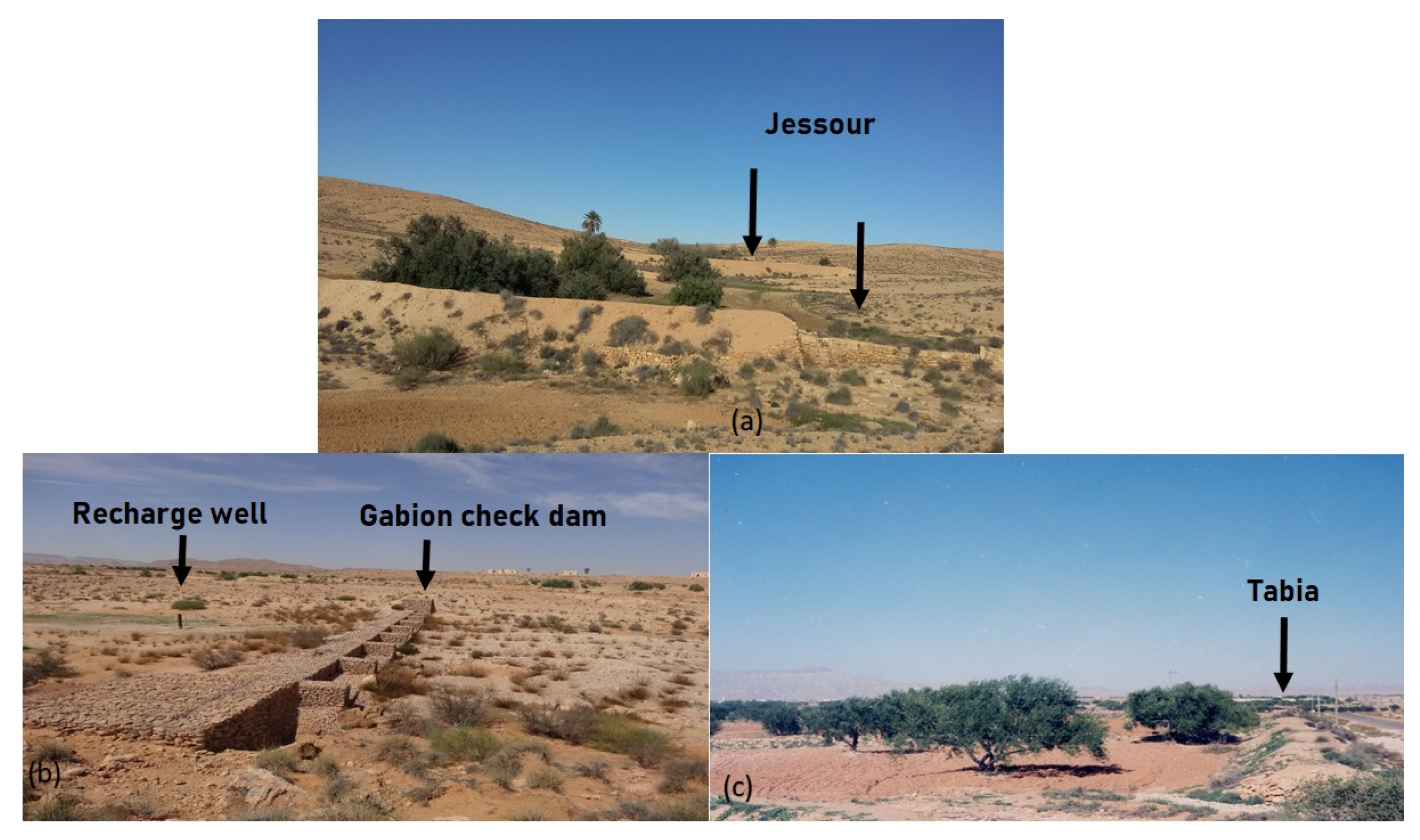
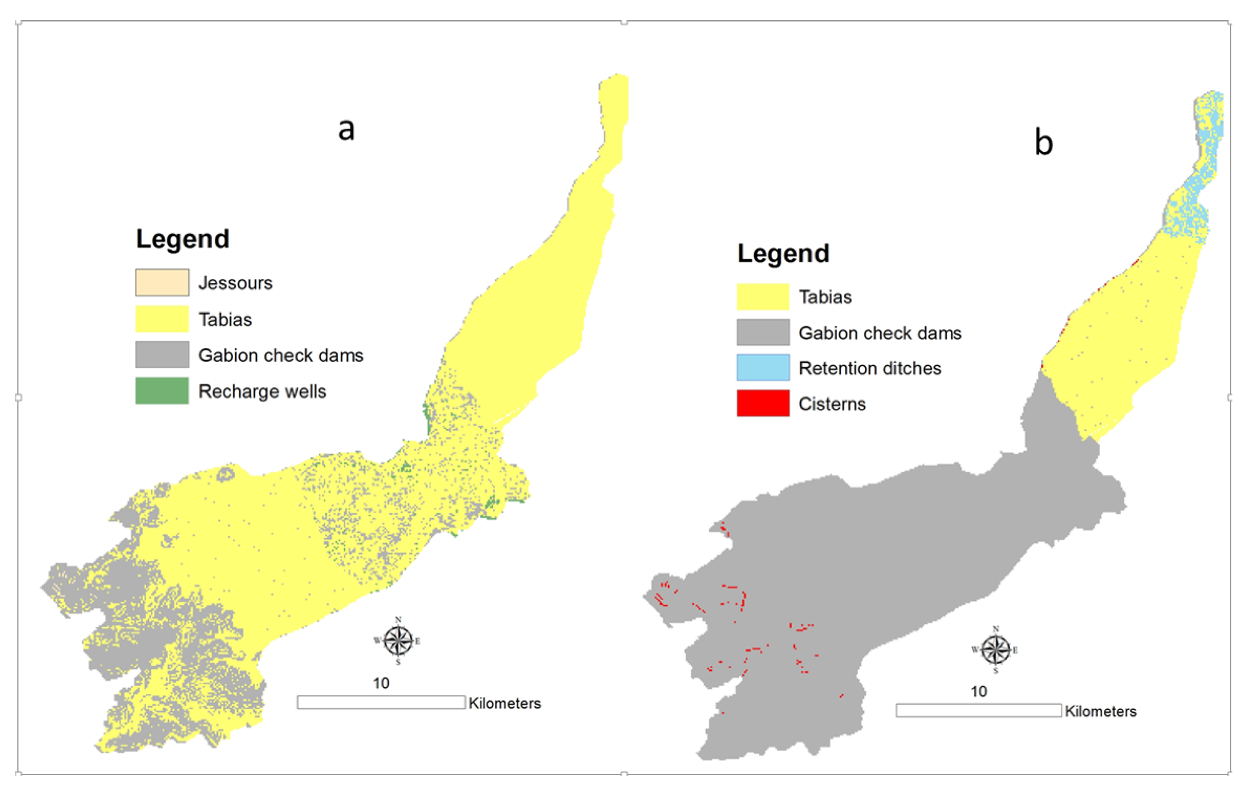
| Jessour | Indigenous | Jessour (plural of jesr) is an ancient runoff water harvesting technique widely practiced in the arid highlands in Tunisia (WOCAT Database). It consists of small dams built across wadis and gullies to intercept rainwater and sediments. A jesr is composed of three main components: a dike in the form of a small earth embankment with a spillway made of stones, a terrace that represents the cropping area and an impluvium [47,48]. (see Figure 3) |
| Tabias | Indigenous | The tabia earthen dyke is a water harvesting technique used in the foothill and piedmont areas. (WOCAT Database). Tabias (plural of tabia) are hydraulic units situated in the middle of a catchment on moderate slopes. A tabia is formed by an embankment along the contour with lateral bunds. It collects water from an impluvium or by the diversion of wadi runoff [48]. (see Figure 3) |
| Cisterns | Indigenous | Cisterns are reservoirs used for storing rainfall and runoff water for multiple purposes: drinking, animal watering and supplemental irrigation (WOCAT database). |
| Recharge wells | Indigenous | A recharge well comprises a drilled hole up to 30–40 m deep that reaches the water table, and a surrounding filter used to allow the direct injection of floodwater into the aquifer (WOCAT database). (see Figure 3) |
| Gabion check dams | Indigenous | The technology of a check dam is a technique consisting of binding different gabion cages filled with small stones together to form a complete flexible gabion unit (WOCAT database). (see Figure 3) |
| Zai planting holes | Introduced (Burkina Faso) | Zai is an ancestral planting pit developed in the Yatenga province, north-western Burkina Faso, where average rainfall is about 600 mm, with recurrent droughts and where soils are heavily encrusted [49]. |
| Retention ditches | Introduced (Ethiopia) | Retention ditches, also called infiltration ditches, are larger ditches designed to catch and retain all incoming runoff for infiltration into the soil [50]. |
| Sustainability Dimensions | Weight (1) | Criteria | Weight (2) | Overall Weight (1 × 2) | Average Score (3) | SCI (1 × 2 × 3) |
|---|---|---|---|---|---|---|
| Economic | 0.333 | Construction and maintenance costs | 0.262 | 0.087 | 0.60 | 0.0523 |
| Agriculture yields | 0.308 | 0.103 | 0.65 | 0.0667 | ||
| Agriculture incomes | 0.431 | 0.144 | 0.65 | 0.0933 | ||
| Environmental | 0.356 | Soil and water conservation | 0.362 | 0.129 | 0.80 | 0.1031 |
| Biodiversity conservation | 0.298 | 0.106 | 0.80 | 0.0849 | ||
| Deep aquifer recharge | 0.340 | 0.121 | 0.35 | 0.0424 | ||
| Social | 0.311 | Unemployment reduction | 0.418 | 0.130 | 0.55 | 0.0715 |
| Food security reinforcement | 0.328 | 0.102 | 0.65 | 0.0663 | ||
| Social conflicts resolution | 0.254 | 0.079 | 0.70 | 0.0553 | ||
| Total | 1 | 1 | 0.6357 |
| Parameters | Ratings | Score | References | ||||||
|---|---|---|---|---|---|---|---|---|---|
| Jessour | Tabias | Cisterns | Zai | Retention Ditches | Recharge Wells | Gabion Check Dams | |||
| Slope (%) | <5 | 4 | 8 | 4 | 8 | 8 | 6 | 6 | [54,55,56] |
| ≥5, <15 | 8 | 6 | 6 | 4 | 4 | 8 | 8 | ||
| ≥15, <20 | 6 | 4 | 8 | 0 | 0 | 2 | 2 | ||
| ≥20 | 2 | 0 | 6 | 0 | 0 | 0 | 0 | ||
| Land use | Cereals | 8 | 10 | 4 | 6 | 4 | 2 | 6 | [54,55] |
| Sand | 2 | 2 | 0 | 0 | 0 | 0 | 0 | ||
| Halophytes | 2 | 2 | 0 | 0 | 2 | 0 | 0 | ||
| Olive | 10 | 10 | 6 | 4 | 8 | 6 | 8 | ||
| Rangelands | 6 | 8 | 8 | 4 | 6 | 6 | 4 | ||
| Rocks | 0 | 0 | 4 | 0 | 0 | 0 | 0 | ||
| Bare soil | 0 | 2 | 0 | 0 | 0 | 0 | 0 | ||
| Distance to wadis (m) | <5000 | 8 | 8 | 8 | 4 | 4 | 10 | 10 | [57,58] |
| ≥5000, <10,000 | 6 | 6 | 6 | 2 | 6 | 8 | 8 | ||
| ≥10,000, <15,000 | 4 | 4 | 4 | 0 | 4 | 6 | 6 | ||
| ≥15,000 | 2 | 2 | 2 | 0 | 2 | 4 | 4 | ||
| Distance to road (m) | <5000 | 8 | 8 | 0 | 0 | 0 | 8 | 10 | [58,59,60] |
| ≥5000, <10,000 | 4 | 4 | 0 | 0 | 0 | 6 | 8 | ||
| ≥10,000, <15,000 | 6 | 6 | 0 | 0 | 0 | 4 | 6 | ||
| ≥15,000 | 2 | 2 | 0 | 0 | 0 | 2 | 2 | ||
| Stakeholders | Techniques | Percentage (%) | Area (km2) |
|---|---|---|---|
| Decision-makers | Tabias | 19.3 | 69.71 |
| Gabion check dams | 78.1 | 282.13 | |
| Retention ditches | 2.3 | 8.22 | |
| Cisterns | 0.3 | 1.26 | |
| Farmers | Jessour | 0.1 | 0.25 |
| Tabias | 75.4 | 272.28 | |
| Gabion check dams | 23.8 | 86.00 | |
| Recharge well | 0.8 | 2.78 | |
| Total area (km2) | 361.32 |
Publisher’s Note: MDPI stays neutral with regard to jurisdictional claims in published maps and institutional affiliations. |
© 2022 by the authors. Licensee MDPI, Basel, Switzerland. This article is an open access article distributed under the terms and conditions of the Creative Commons Attribution (CC BY) license (https://creativecommons.org/licenses/by/4.0/).
Share and Cite
Abdeladhim, M.A.; Fleskens, L.; Baartman, J.; Sghaier, M.; Ouessar, M.; Ritsema, C.J. Generation of Potential Sites for Sustainable Water Harvesting Techniques in Oum Zessar Watershed, South East Tunisia. Sustainability 2022, 14, 5754. https://doi.org/10.3390/su14105754
Abdeladhim MA, Fleskens L, Baartman J, Sghaier M, Ouessar M, Ritsema CJ. Generation of Potential Sites for Sustainable Water Harvesting Techniques in Oum Zessar Watershed, South East Tunisia. Sustainability. 2022; 14(10):5754. https://doi.org/10.3390/su14105754
Chicago/Turabian StyleAbdeladhim, Mohamed Arbi, Luuk Fleskens, Jantiene Baartman, Mongi Sghaier, Mohamed Ouessar, and Coen J. Ritsema. 2022. "Generation of Potential Sites for Sustainable Water Harvesting Techniques in Oum Zessar Watershed, South East Tunisia" Sustainability 14, no. 10: 5754. https://doi.org/10.3390/su14105754