


Recreation Potential Assessment at Tamarix Forest Reserves: A Method Based on Multicriteria Evaluation Approach and Landscape Metrics
 ,
,  , and
, and
Abstract
:1. Introduction
- Among the studied areas, which parts have the potential for outdoor recreation?
- Among the ecological factors examined in this research, which factor plays a more important role in evaluating the suitability of the area for outdoor recreation?
- What are the differences in the final output between the two methods: the multicriteria assessment and the landscape approach?
- Can the combination of two methods (the multicriteria evaluation and the landscape approach) be used as a suitable single method to evaluate the suitability of the area for outdoor recreation?
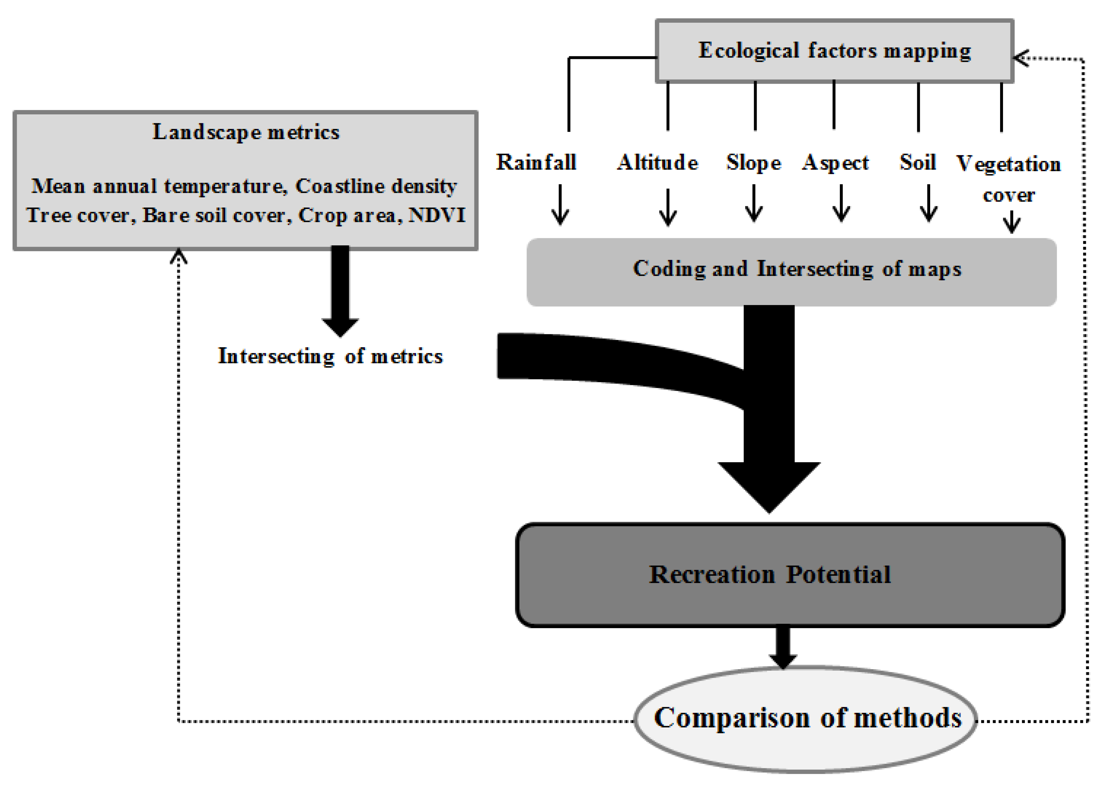
2. Materials and Methods
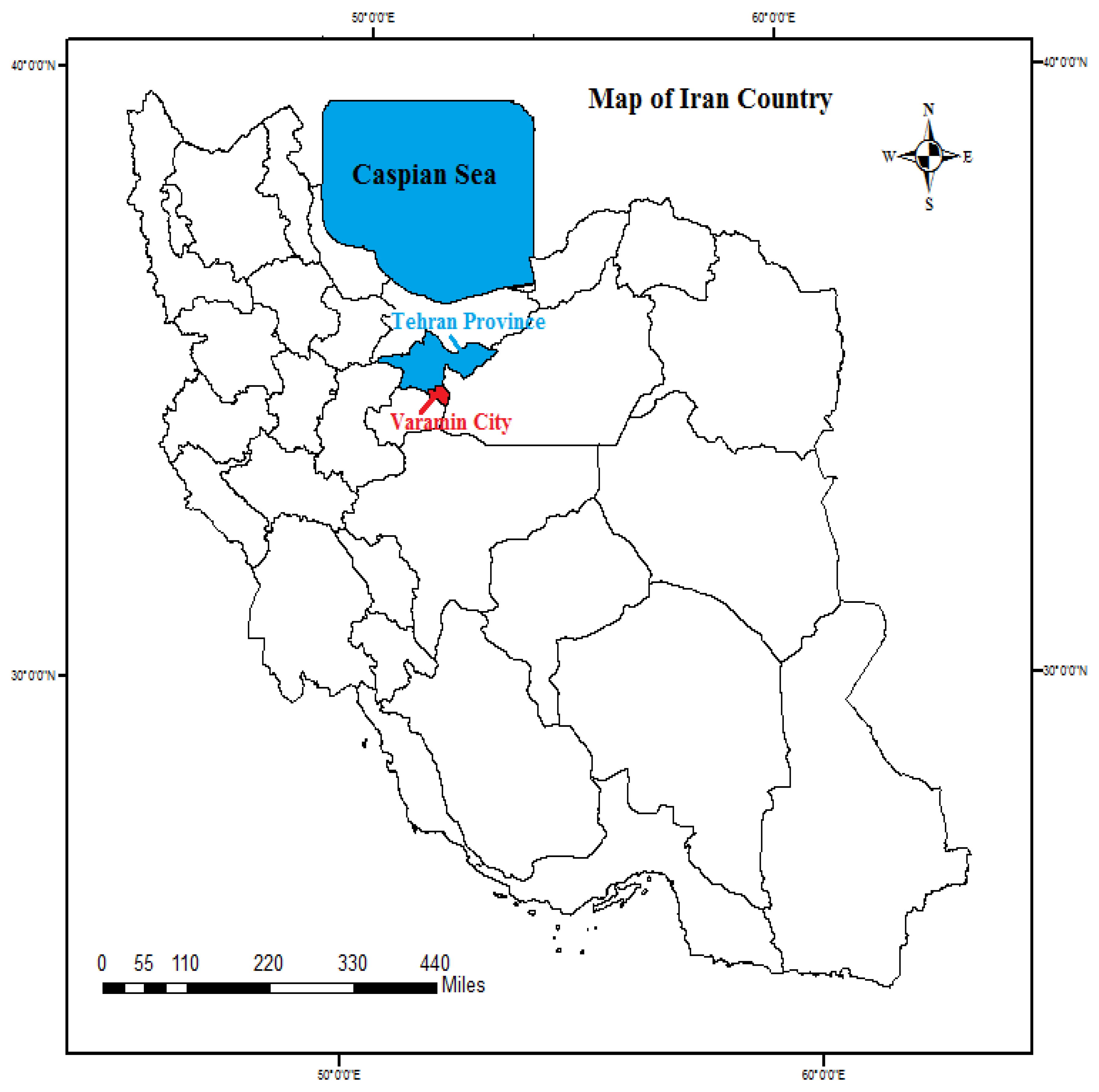
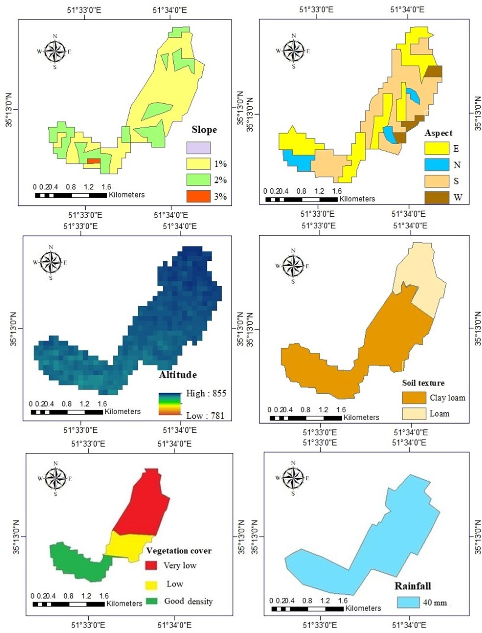
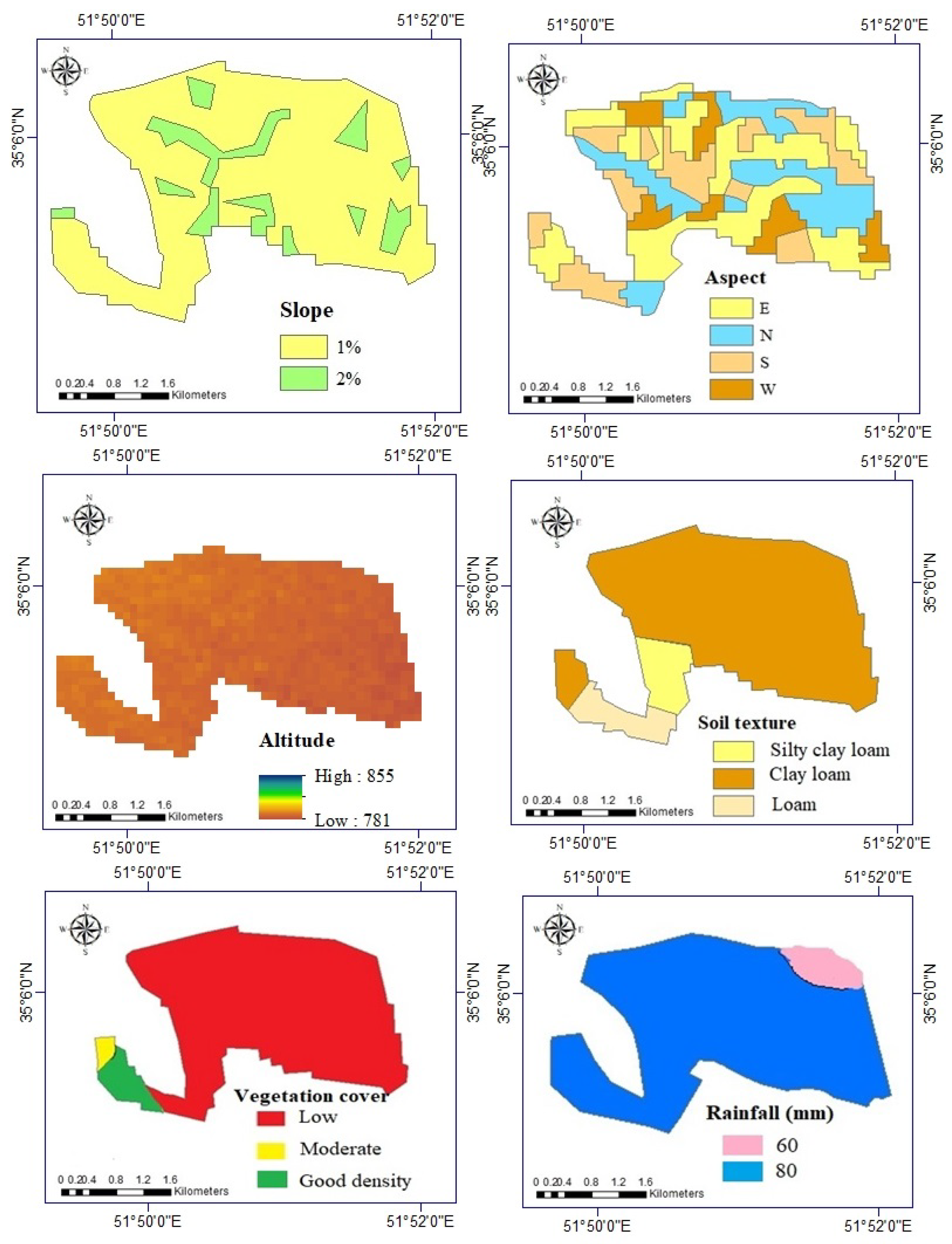
2.1. Study Area
- Elevation:
- 2.
- Slope:
- 3.
- Aspect:
- 4.
- Temperature and rainfall:
- 5.
- Vegetation density:
- 6.
- Soil:
2.2. Landscape Approach
3. Results
Landscape Approach
4. Discussion
5. Conclusions
Author Contributions
Funding
Institutional Review Board Statement
Informed Consent Statement
Data Availability Statement
Acknowledgments
Conflicts of Interest
References
- Li, X.; Zhang, X.; Jia, T. Humanization of nature: Testing the influences of urban park characteristics and psychological factors on collegers’ perceived restoration. Urban For. Urban Green. 2023, 79, 127806. [Google Scholar] [CrossRef]
- Zhao, L.; Du, M.; Du, W.; Guo, J.; Liao, Z.; Kang, X.; Liu, Q. Evaluation of the Carbon Sink Capacity of the Proposed Kunlun Mountain National Park. Int. J. Environ. Res. Public Health 2022, 19, 9887. [Google Scholar] [CrossRef] [PubMed]
- Xu, Y.; Zhang, Z. The role of forest culture in green construction and management of forest parks: Merging knowledge-attitude-practice and theory of planned behavior. J. For. Res. 2022, 1–12. [Google Scholar] [CrossRef]
- Herzberg, R.; Pham, T.G.; Kappas, M.; Wyss, D.; Tran, C.T.M. Multi-Criteria Decision Analysis for the Land Evaluation of Potential Agricultural Land Use Types in a Hilly Area of Central Vietnam. Land 2019, 8, 90. [Google Scholar] [CrossRef] [Green Version]
- Winter, P.L.; Selin, S.; Cerveny, L.; Bricker, K. Outdoor recreation, nature-based tourism, and sustainability. Sustainability 2019, 12, 81. [Google Scholar] [CrossRef] [Green Version]
- Liu, X.; Tong, D.; Huang, J.; Zheng, W.; Kong, M.; Zhou, G. What matters in the e-commerce era? Modelling and mapping shop rents in Guangzhou, China. Land Use Policy 2022, 123, 106430. [Google Scholar] [CrossRef]
- Shepard, R.B. Quantifying Environmental Impact Assessments Using Fuzzy Logic; Springer: Berlin/Heidelberg, Germany, 2005. [Google Scholar]
- Xu, L.; Liu, X.; Tong, D.; Liu, Z.; Yin, L.; Zheng, W. Forecasting urban land use change based on cellular automata and the PLUS model. Land 2022, 11, 652. [Google Scholar] [CrossRef]
- Tong, D.; Chu, J.; Han, Q.; Liu, X. How land finance drives urban expansion under fiscal pressure: Evidence from Chinese cities. Land 2022, 11, 253. [Google Scholar] [CrossRef]
- Kandari, A.M.; Kasim, S.; Limi, M.A.; Karim, J. Land suitability evaluation for plantation forest development based on multi-criteria approach. Journal Agriculture. For. Fish. 2015, 4, 228–238. [Google Scholar]
- Balmford, A.; Beresford, J.; Green, J.; Naidoo, R.; Walpole, M.; Manica, A. A global perspective on trends in nature-based tourism. PLoS Biol. 2009, 7, e1000144. [Google Scholar] [CrossRef] [Green Version]
- Wajchman-Świtalska, S.; Zajadacz, A.; Woźniak, M.; Jaszczak, R.; Beker, C. Recreational Evaluation of Forests in Urban Environments: Methodological and Practical Aspects. Sustainability 2022, 14, 15177. [Google Scholar] [CrossRef]
- Arriaza, M.; Cañas-Ortega, J.F.; Cañas-Madueño, J.A.; Ruiz-Aviles, P. Assessing the visual quality of rural landscapes. Landsc. Urban Plan. 2004, 69, 115–125. [Google Scholar] [CrossRef]
- Faggi, A.; Breuste, J.; Madanes, N.; Gropper, C.; Perelman, P. Water as an appreciated feature in the landscape: A comparison of residents’ and visitors’ preferences in Buenos Aires. J. Clean. Prod. 2013, 60, 182–187. [Google Scholar] [CrossRef]
- Goossen, M.; Langers, F. Assessing quality of rural areas in the Netherlands: Finding the most important indicators for recreation. Landsc. Urban Plan. 2000, 46, 241–251. [Google Scholar] [CrossRef]
- Fangyong, H. Evaluation of the ecotourism development potential for provinces in western China. J. Arid Land Resour. Environ. 2015, 4, 592–599. [Google Scholar]
- Choudhury, S.; Pant, R.M.; Chatterjee, S.; Nanding, A. Destination Branding of Ziro Through Potentiality of Bio-tourism. In Bioprospecting of Indigenous Bioresources of North-East India; Springer: Singapore, 2016; pp. 329–337. [Google Scholar]
- Weyland, F.; Laterra, P. Recreation potential assessment at large spatial scales: A method based in the ecosystem services approach and landscape metrics. Ecol. Indic. 2014, 39, 34–43. [Google Scholar] [CrossRef]
- García-Llorente, M.; Harrison, P.A.; Berry, P.; Palomo, I.; Gómez-Baggethun, E.; Iniesta-Arandia, I.; Montes, C.; García del Amo, D.; Martín-López, B. What can conservation strategies learn from the ecosystem services approach? Insights from ecosystem assessments in two Spanish protected areas. Biodivers. Conserv. 2018, 27, 1575–1597. [Google Scholar] [CrossRef] [Green Version]
- Herold, M.; Scepan, J.; Clarke, K.C. The use of remote sensing and landscape metrics to describe structures and changes in urban land uses. Environ. Plan. A 2002, 34, 1443–1458. [Google Scholar] [CrossRef] [Green Version]
- Masteali, S.H.; Bettinger, P.; Bayat, M.; Amiri, B.J.; Awan, H.U.M. Comparison between graph theory connectivity indices and landscape connectivity metrics for modeling river water quality in the southern Caspian sea basin. J. Environ. Manag. 2023, 328, 116965. [Google Scholar] [CrossRef]
- Dağıstanlı, C.; Turan, İ.D.; Dengiz, O. Evaluation of the suitability of sites for outdoor recreation using a multi-criteria assessment model. Arab. J. Geosci. 2018, 11, 492. [Google Scholar] [CrossRef]
- Zhang, J.-T.; Xiang, C.; Li, M. Effects of tourism and topography on vegetation diversity in the subalpine meadows of the Dongling Mountains of Beijing, China. Environ. Manag. 2012, 49, 403–411. [Google Scholar] [CrossRef] [PubMed]
- Brabyn, L.; Mark, D. Using viewsheds, GIS, and a landscape classification to tag landscape photographs. Appl. Geogr. 2011, 31, 1115–1122. [Google Scholar] [CrossRef]
- Clark, R.N.; Stankey, G.H. The Recreation Opportunity Spectrum: A Framework for Planning, Management, and Research; US Department of Agriculture, Forest Service, Pacific Northwest Forest and Research Station: Washington, DC, USA, 1979; Volume 98. [Google Scholar]
- Haas, G.; Aukerman, G.V.; Jackson, J. Water and Land Recreation Opportunity Spectrum Handbook; US Department of the Interior, Bureau of Reclamation, Program and Administration, Denver Federal Center: Denver, CO, USA, 2011; Volume 17, pp. 491–499. [Google Scholar]
- Merry, K.; Bettinger, P.; Siry, J.; Bowker, J.; Weaver, S.; Ucar, Z. Mapping potential motorised sightseeing recreation supply across broad privately-owned landscapes of the Southern United States. Landsc. Res. 2018, 43, 721–734. [Google Scholar] [CrossRef]
- Gül, A.; Örücü, M.K.; Karaca, Ö. An approach for recreation suitability analysis to recreation planning in Gölcük Nature Park. Environ. Manag. 2006, 37, 606–625. [Google Scholar] [CrossRef] [PubMed]
- Liu, D.; Kwan, M.-P.; Kan, Z. Analysis of urban green space accessibility and distribution inequity in the City of Chicago. Urban For. Urban Green. 2021, 59, 127029. [Google Scholar] [CrossRef]
- Bayat, M.; Bettinger, P.; Heidari, S.; Hamidi, S.K.; Jaafari, A. A combination of biotic and abiotic factors and diversity determine productivity in natural deciduous forests. Forests 2021, 12, 1450. [Google Scholar] [CrossRef]
- Bayat, M.; Knoke, T.; Heidari, S.; Hamidi, S.K.; Burkhart, H.; Jaafari, A. Modeling Tree Growth Responses to Climate Change: A Case Study in Natural Deciduous Mountain Forests. Forests 2022, 13, 1816. [Google Scholar] [CrossRef]
- Kliskey, A. Recreation terrain suitability mapping: A spatially explicit methodology for determining recreation potential for resource use assessment. Landsc. Urban Plan. 2000, 52, 33–43. [Google Scholar] [CrossRef]
- Brown, G.; Weber, D. Public Participation GIS: A new method for national park planning. Landsc. Urban Plan. 2011, 102, 1–15. [Google Scholar] [CrossRef]
- D’Antonio, A.; Monz, C.; Newman, P.; Lawson, S.; Taff, D. Enhancing the utility of visitor impact assessment in parks and protected areas: A combined social–ecological approach. J. Environ. Manag. 2013, 124, 72–81. [Google Scholar] [CrossRef]
- Chan, K.M.A.; Shaw, M.R.; Cameron, D.R.; Underwood, E.C.; Daily, G.C. Conservation planning for ecosystem services. PLoS Biol. 2006, 4, e379. [Google Scholar] [CrossRef] [PubMed] [Green Version]
- Salehnasab, A.; Bayat, M.; Namiranian, M.; Khaleghi, B.; Omid, M.; Masood Awan, H.U.; Al-Ansari, N.; Jaafari, A. Machine learning for the estimation of diameter increment in mixed and uneven-aged forests. Sustainability 2022, 14, 3386. [Google Scholar] [CrossRef]
- Bayat, M.; Burkhart, H.; Namiranian, M.; Hamidi, S.K.; Heidari, S.; Hassani, M. Assessing biotic and abiotic effects on biodiversity index using machine learning. Forests 2021, 12, 461. [Google Scholar] [CrossRef]
- Bayat, M.; Bettinger, P.; Hassani, M.; Heidari, S. Ten-year estimation of Oriental beech (Fagus orientalis Lipsky) volume increment in natural forests: A comparison of an artificial neural networks model, multiple linear regression and actual increment. For. Int. J. For. Res. 2021, 94, 598–609. [Google Scholar] [CrossRef]
- Li, J.; Wang, Z.; Wu, X.; Xu, C.-Y.; Guo, S.; Chen, X. Toward monitoring short-term droughts using a novel daily scale, standardized antecedent precipitation evapotranspiration index. J. Hydrometeorol. 2020, 21, 891–908. [Google Scholar] [CrossRef] [Green Version]
- Arbieu, U.; Grünewald, C.; Schleuning, M.; Böhning-Gaese, K. The importance of vegetation density for tourists’ wildlife viewing experience and satisfaction in African savannah ecosystems. PLoS ONE 2017, 12, e0185793. [Google Scholar] [CrossRef] [Green Version]
- Li, W.; Shi, Y.; Zhu, D.; Wang, W.; Liu, H.; Li, J.; Shi, N.; Ma, L.; Fu, S. Fine root biomass and morphology in a temperate forest are influenced more by the nitrogen treatment approach than the rate. Ecol. Indic. 2021, 130, 108031. [Google Scholar] [CrossRef]
- Cetin, M.; Zeren, I.; Sevik, H.; Cakir, C.; Akpinar, H. A study on the determination of the natural park’s sustainable tourism potential. Environ. Monit. Assess. 2018, 190, 167. [Google Scholar] [CrossRef]
- Yang, Y.; Chen, X.; Liu, L.; Li, T.; Dou, Y.; Qiao, J.; Wang, Y.; An, S.; Chang, S.X. Nitrogen fertilization weakens the linkage between soil carbon and microbial diversity: A global meta-analysis. Glob. Chang. Biol. 2022, 28, 6446–6461. [Google Scholar] [CrossRef]
- Wu, X.; Guo, S.; Qian, S.; Wang, Z.; Lai, C.; Li, J.; Liu, P. Long-range precipitation forecast based on multipole and preceding fluctuations of sea surface temperature. Int. J. Climatol. 2022, 42, 8024–8039. [Google Scholar] [CrossRef]
- Bettinger, P.; Merry, K.; Bayat, M.; Tomaštík, J. GNSS use in forestry—A multi-national survey from Iran, Slovakia and southern USA. Comput. Electron. Agric. 2019, 158, 369–383. [Google Scholar] [CrossRef]
- Yang, Y.; Li, T.; Pokharel, P.; Liu, L.; Qiao, J.; Wang, Y.; An, S.; Chang, S.X. Global effects on soil respiration and its temperature sensitivity depend on nitrogen addition rate. Soil Biol. Biochem. 2022, 174, 108814. [Google Scholar] [CrossRef]
- Yang, Y.; Dou, Y.; Wang, B.; Xue, Z.; Wang, Y.; An, S.; Chang, S.X. Deciphering factors driving soil microbial life-history strategies in restored grasslands. iMeta 2022, 2, e66. [Google Scholar] [CrossRef]
- Hamidi, S.K.; de Luis, M.; Bourque, C.P.-A.; Bayat, M.; Serrano-Notivoli, R. Projected biodiversity in the Hyrcanian Mountain Forest of Iran: An investigation based on two climate scenarios. Biodivers. Conserv. 2022, 1–18. [Google Scholar] [CrossRef]
- Booth, K.L.; Cessford, G.; McCool, S.; Espiner, S. Exploring visitor experiences, crowding perceptions and coping strategies on the Milford Track, New Zealand. Sci. Conserv. 2011, 313, 91. [Google Scholar]
- Sildoja, J.; Eagles, P.F. Campsite use levels compared to campsite attributes in Emily provincial park, Ontario. In Proceedings of the Making Ecosystem Based Management Work, Fifth International Conference on Science and Management of Protected Areas (SAMPAA Canada), Victoria, BC, Canada, 11–16 May 2003; pp. 11–16. [Google Scholar]
- Zhang, Q.; Ge, L.; Hensley, S.; Metternicht, G.I.; Liu, C.; Zhang, R. PolGAN: A deep-learning-based unsupervised forest height estimation based on the synergy of PolInSAR and LiDAR data. ISPRS J. Photogramm. Remote Sens. 2022, 186, 123–139. [Google Scholar] [CrossRef]
- Perren, J. La calidad ambiental en la Argentina: Análisis regional y departamental (C. 2010). Población Y Soc. 2014, 21, 146–148. [Google Scholar]
- Butowski, L. Tourism: From Empirical Research Towards Practical Application; BoD–Books on Demand: Norderstedt, Germany, 2016. [Google Scholar]
- Yan, Y.; Jarvie, S.; Liu, Q.; Zhang, Q. Effects of fragmentation on grassland plant diversity depend on the habitat specialization of species. Biol. Conserv. 2022, 275, 109773. [Google Scholar] [CrossRef]
- Zhensikbayeva, N.Z.; Saparov, K.T.; Chlachula, J.; Yegorina, A.V.; Uruzbayeva, N.A.; Wendt, J.A. Natural potential for tourism development in Southern Altai (Kazakhstan). GeoJ. Tour. Geosites 2018, 21, 200–212. [Google Scholar]
- Frank, S.; Fürst, C.; Koschke, L.; Witt, A.; Makeschin, F. Assessment of landscape aesthetics—Validation of a landscape metrics-based assessment by visual estimation of the scenic beauty. Ecol. Indic. 2013, 32, 222–231. [Google Scholar] [CrossRef]
- Van Zanten, B.T.; Zasada, I.; Koetse, M.J.; Ungaro, F.; Häfner, K.; Verburg, P.H. A comparative approach to assess the contribution of landscape features to aesthetic and recreational values in agricultural landscapes. Ecosyst. Serv. 2016, 17, 87–98. [Google Scholar] [CrossRef]
- Colson, V.; Garcia, S.; Rondeux, J.; Lejeune, P. Map and determinants of woodlands visiting in Wallonia. Urban For. Urban Green. 2010, 9, 83–91. [Google Scholar] [CrossRef]
- Plieninger, T.; Dijks, S.; Oteros-Rozas, E.; Bieling, C. Assessing, mapping, and quantifying cultural ecosystem services at community level. Land Use Policy 2013, 33, 118–129. [Google Scholar] [CrossRef] [Green Version]
- Eigenbrod, F.; Armsworth, P.R.; Anderson, B.J.; Heinemeyer, A.; Gillings, S.; Roy, D.B.; Thomas, C.D.; Gaston, K.J. The impact of proxy-based methods on mapping the distribution of ecosystem services. J. Appl. Ecol. 2010, 47, 377–385. [Google Scholar] [CrossRef]


| Variable | Source | Expected Effect on Recreation Potential |
|---|---|---|
| Elevation | The DEM map (year of 2020) was extracted from the https://urs.earthdata.nasa.gov/ site (accessed on 8 February 2020) | Elevation is an important feature in environmental studies because it has a direct effect on other ecological factors such as precipitation and temperature [36]. |
| Slope | DEM, along with ArcGIS 10.3 software, to develop a slope map. | The morphology and slope of the basin is one of the main parameters in environmental studies that, in addition to a direct effect on the intensity of water flow, also affects other physical characteristics of the basin [37]. |
| Aspect | DEM and the Aspect tool was used in the ArcMap environment, and after creating the aspect map and necessary corrections, such as removing very small directions and merging them with larger directions. | The aspect of the domain and its changes play an important role in changing its environment. The most important effect of the aspect of the slope manifests itself in the form of differences in weather conditions [38]. |
| Temperature and rainfall | The temperature and rainfall map was taken from the regional meteorological department; it included the isolines with ArcMap. | Climate is one of the most important geophysical factors that play an important role in the establishment or nonestablishment of human settlements. Therefore, the climate is an important criterion in the establishment of tourist centers [39]. |
| Vegetation density | Field visiting, report, and mapping by ArcMap. | The higher the vegetation density, the higher the tourism potential for this purpose [40,41]. |
| Soil | Field work, sampling with plots, lab analysis, and mapping by ArcMap. | Soil erosion is one of the most fundamental environmental, agricultural, and food production problems in the world that has devastating effects on all natural and fabricated ecosystems. Soil loss is, therefore, recognized as a serious environmental problem [42,43]. |
| Desirability Code | Geographical Aspect | Desirability Code | Slope (%) | Desirability Code | Elevation (m) |
|---|---|---|---|---|---|
| 1 | North | 0–2 | 1 | 1 | >1000 |
| 1 | Eastern | 2–5 | 2 | ||
| 2 | South | ||||
| 2 | Western |
| Desirability Code | Temperature (°C) | Desirability Code | Rainfall (mm) |
|---|---|---|---|
| 1 | 21–25 | 3 | >40 |
| 2 | 40–60 | ||
| 1 | More than 60 |
| Desirability Code | Vegetation Density (%) |
|---|---|
| 1 | More than 40 |
| 2 | 20–40 |
| 3 | 0–20 |
| Variable | Description | Expected Effect on Recreation Potential | Source |
|---|---|---|---|
| Mean annual temperature | The average annual temperature of each region was calculated and determined using isothermal lines. | Temperature plays an important role in outdoor recreation, as extreme temperatures restrict activities such as camping. [48,49]. | Information of meteorological stations in the region (map of isothermal lines of the region). |
| Coastline density | River, streams, lakes (km coastline/km2). | Rivers allow activities such as swimming and fishing [14]. | Hydrographic layer of study area. |
| Tree cover | Percent tree cover. | Vegetation percentage is one of the most important factors in outdoor recreation because this factor determines the shade percentage [50,51]. | Satellite images of the study area. |
| Bare soil cover | Percent bare soil. | If the proportion of bare soil in the area is high, it will cause problems for activities such as camping due to the lack of shade and harsh weather conditions [28]. | Satellite images of the study area. |
| Crop area | Percent herbaceous and shrub crops and forestations. | Human activities such as agriculture diminish scenic value and recreation activities [52]. | Satellite images of the study area. |
| NDVI | Normalized Difference Vegetation Index as an indicator of lush vegetation. | Landscapes with lush vegetation are preferred by recreationists [52]. | Satellite images of the study area. |
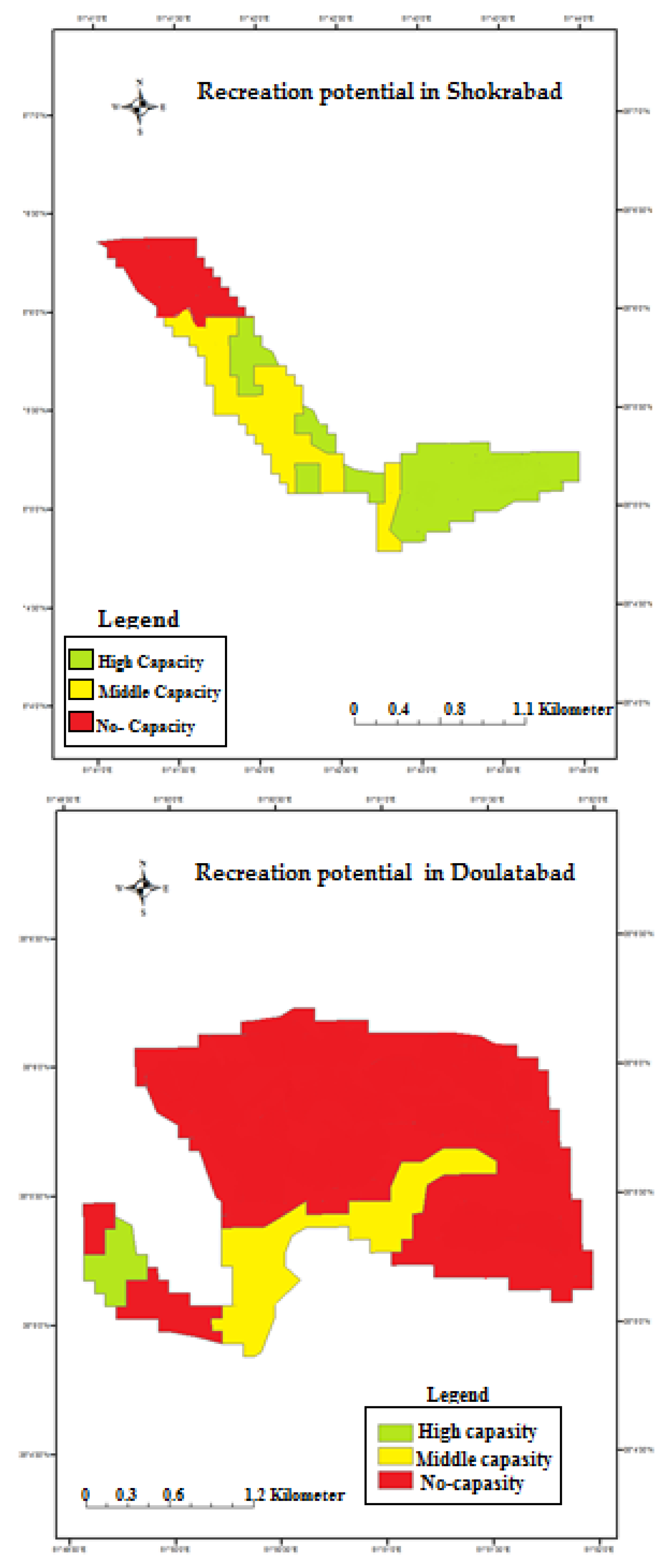
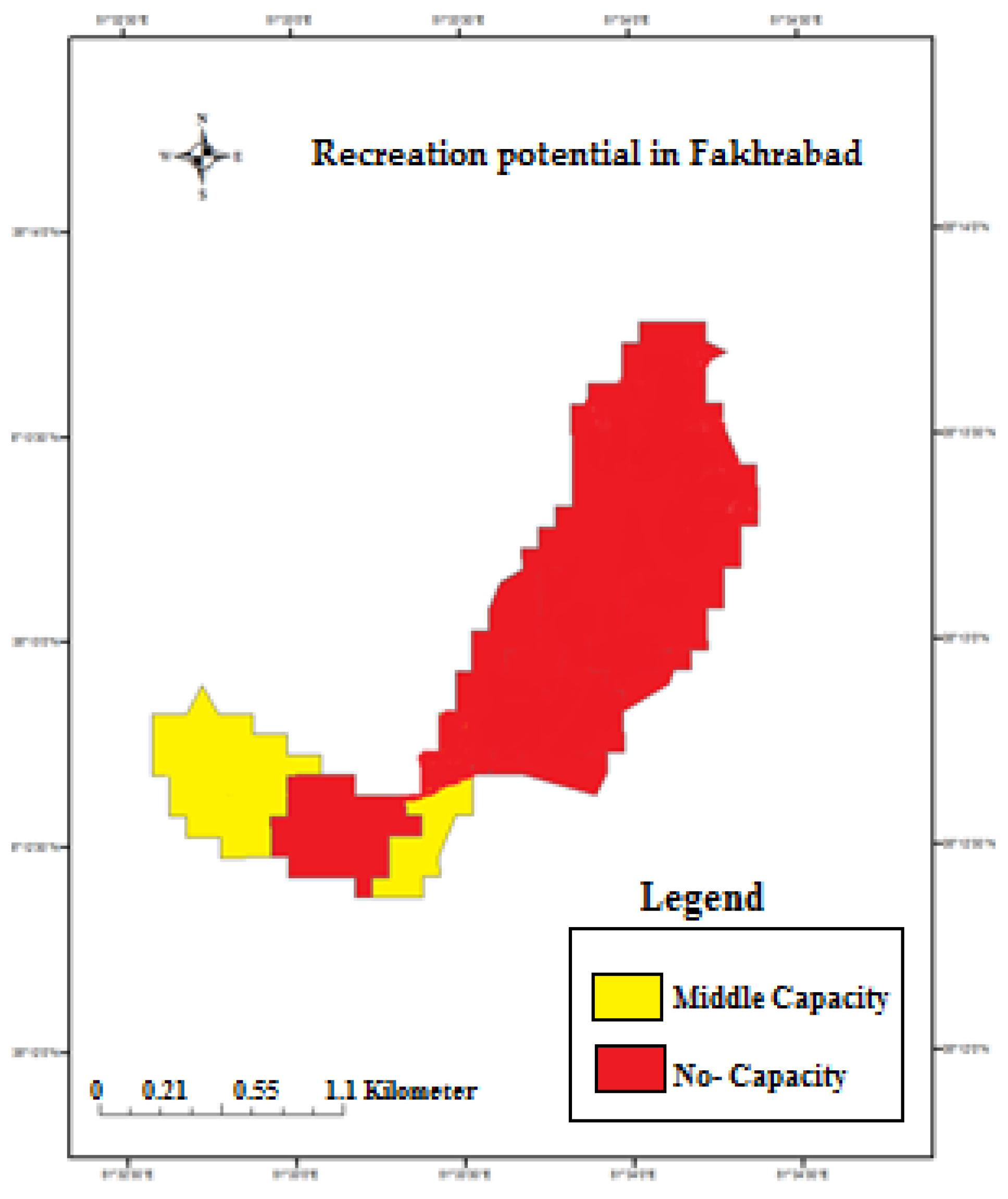
| Region | High Capacity | Middle Capacity | No Capacity |
|---|---|---|---|
| Shokrabad | 2.11 | 1.49 | 0.51 |
| Fakhrabad | 0 | 0.37 | 2.66 |
| Dolatabad | 0.05 | 0.44 | 5.78 |
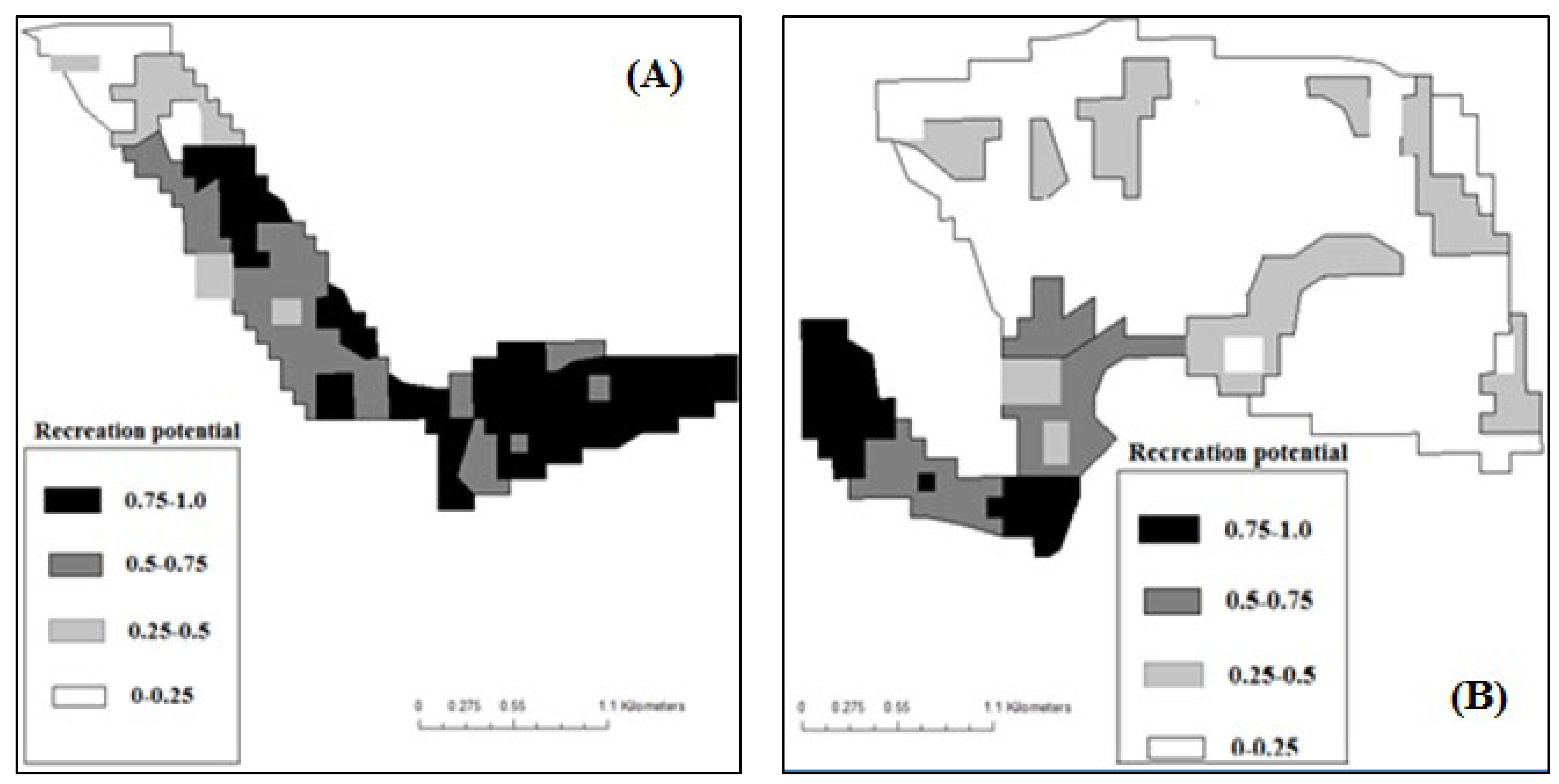
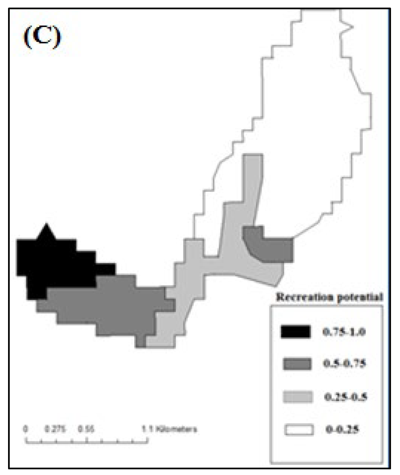
| Region | Class 1 (0.75–1) | Class 2 (0.75–0.5) | Class 3 (0.5–0.25) | Class 4 (0–0.25) |
|---|---|---|---|---|
| Shokrabad | 1.87 | 1.62 | 0.18 | 0.44 |
| Fakhrabad | 0.28 | 0.53 | 0.50 | 1.72 |
| Dolatabad | 0.30 | 0.1 | 0.75 | 5.12 |
Disclaimer/Publisher’s Note: The statements, opinions and data contained in all publications are solely those of the individual author(s) and contributor(s) and not of MDPI and/or the editor(s). MDPI and/or the editor(s) disclaim responsibility for any injury to people or property resulting from any ideas, methods, instructions or products referred to in the content. |
© 2023 by the authors. Licensee MDPI, Basel, Switzerland. This article is an open access article distributed under the terms and conditions of the Creative Commons Attribution (CC BY) license (https://creativecommons.org/licenses/by/4.0/).
Share and Cite
Bayat, M.; Bettinger, P.; Masteali, S.H.; Hamidi, S.K.; Masood Awan, H.U.; Abolhasani, A. Recreation Potential Assessment at Tamarix Forest Reserves: A Method Based on Multicriteria Evaluation Approach and Landscape Metrics. Forests 2023, 14, 705. https://doi.org/10.3390/f14040705
Bayat M, Bettinger P, Masteali SH, Hamidi SK, Masood Awan HU, Abolhasani A. Recreation Potential Assessment at Tamarix Forest Reserves: A Method Based on Multicriteria Evaluation Approach and Landscape Metrics. Forests. 2023; 14(4):705. https://doi.org/10.3390/f14040705
Chicago/Turabian StyleBayat, Mahmoud, Pete Bettinger, Sahar Heidari Masteali, Seyedeh Kosar Hamidi, Hafiz Umair Masood Awan, and Azam Abolhasani. 2023. "Recreation Potential Assessment at Tamarix Forest Reserves: A Method Based on Multicriteria Evaluation Approach and Landscape Metrics" Forests 14, no. 4: 705. https://doi.org/10.3390/f14040705