

Characterization of Forest Ecosystems in the Chure (Siwalik Hills) Landscape of Nepal Himalaya and Their Conservation Need
 , , ,
, , ,  ,
,  and
and
Abstract
:1. Introduction
2. Materials and Methods
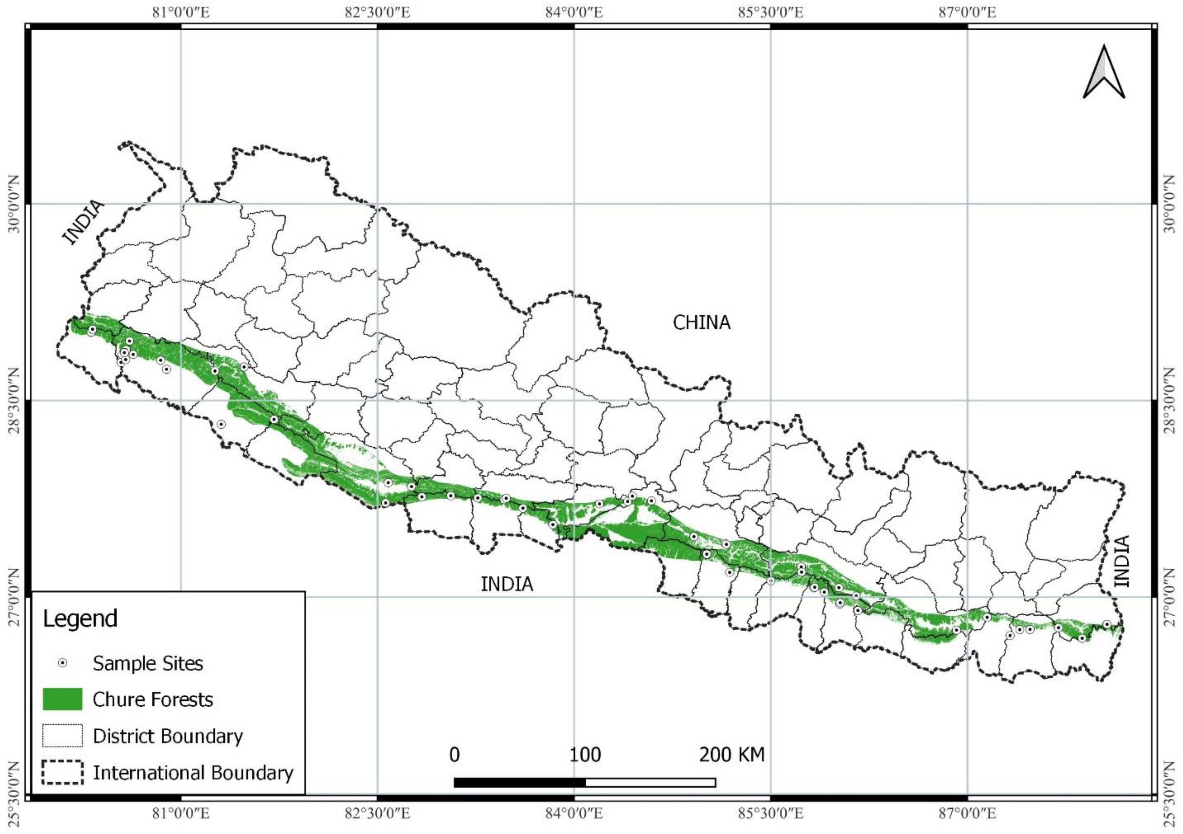
2.1. Study Area
2.2. Methods
2.2.1. Sampling Procedures
2.2.2. Assessment of Regeneration Status and Disturbances
2.2.3. Stakeholder Consultation
2.2.4. Plant Identification
3. Results and Discussion
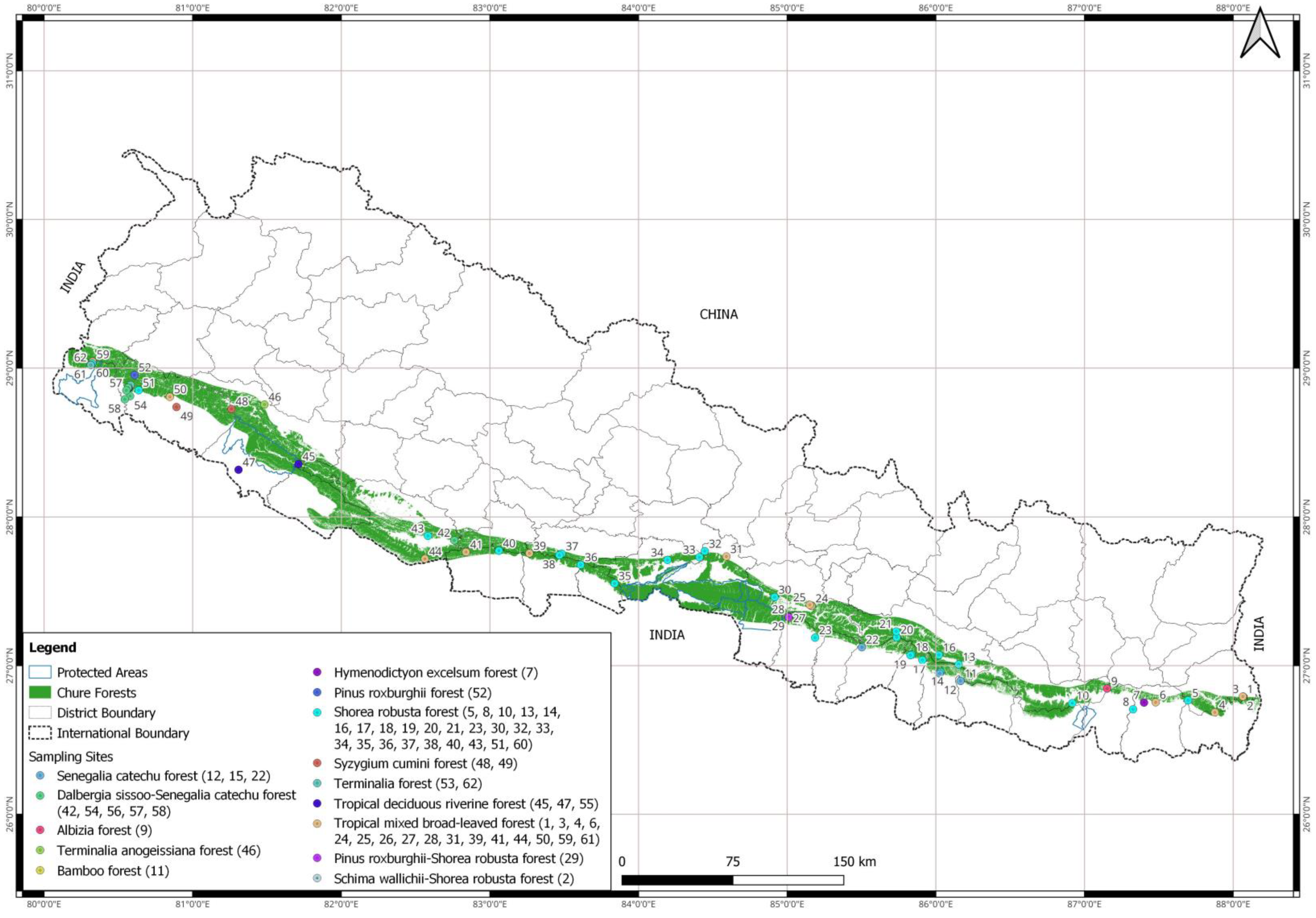
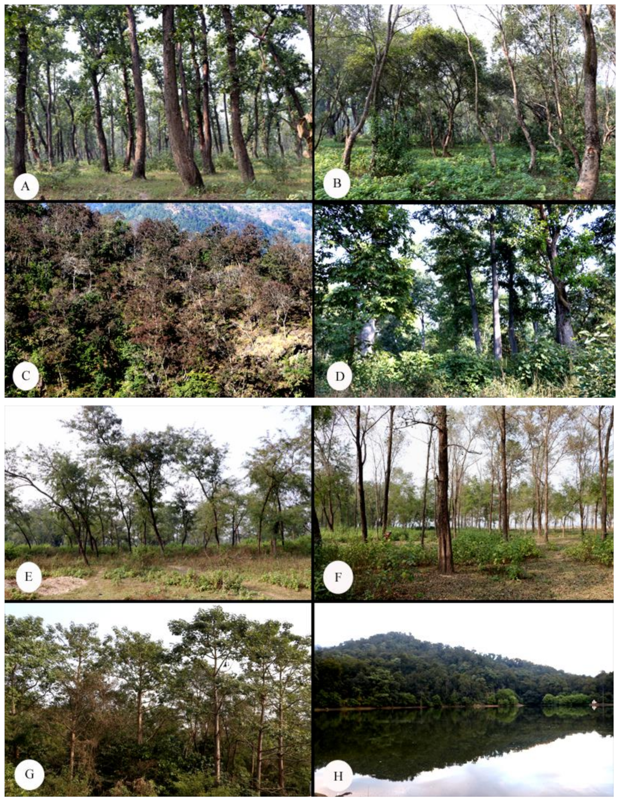
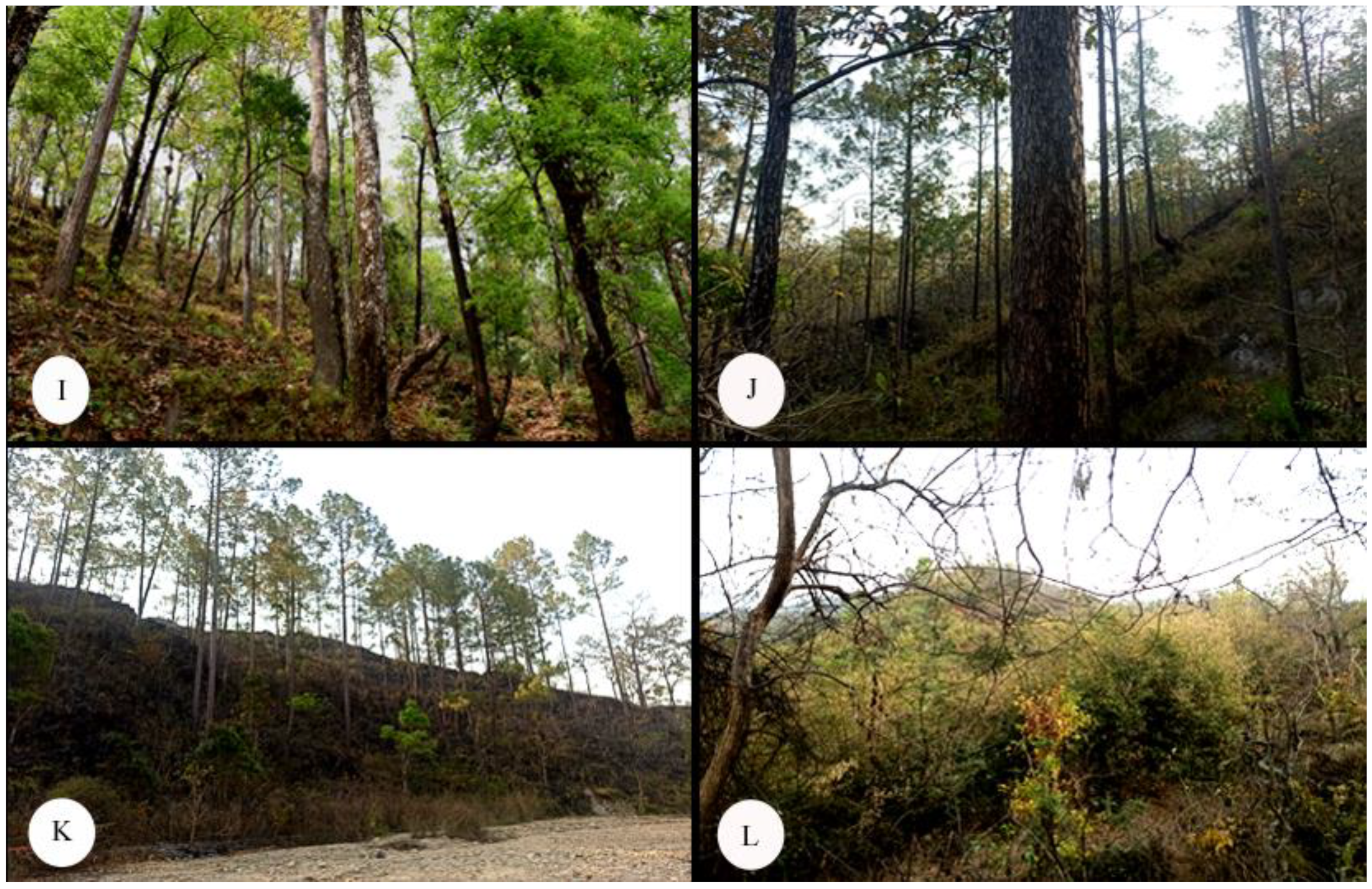
3.1. Forests and Ecosystems Types
3.2. Threats and Vulnerabilities
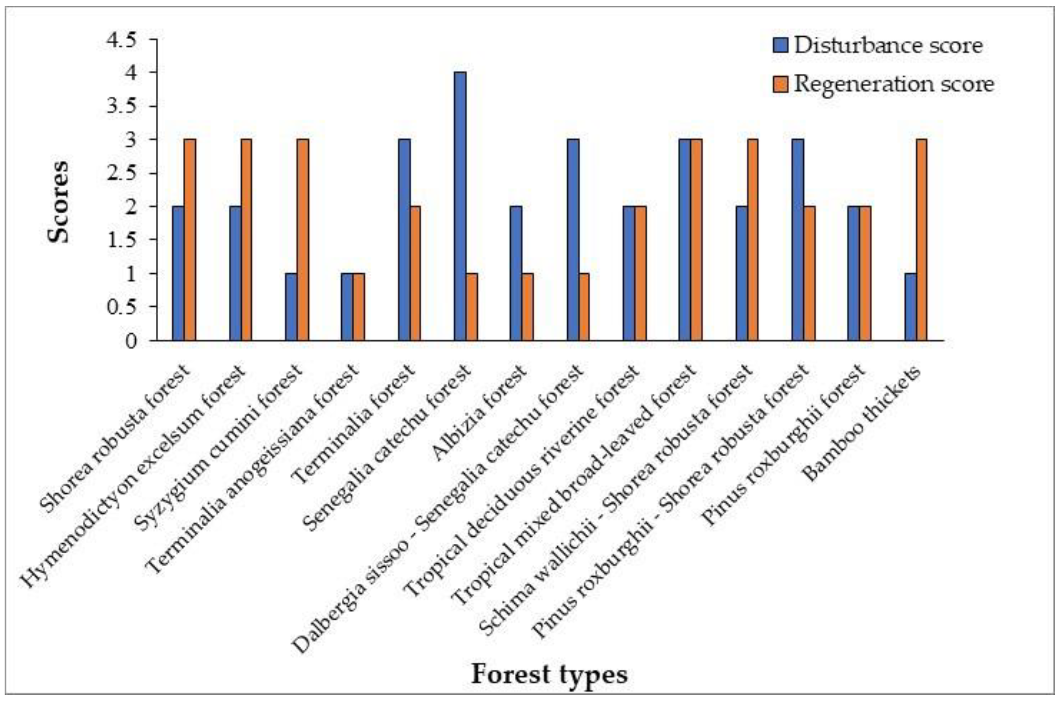
3.3. Forest Regeneration
3.4. Floral and Faunal Biodiversity of Chure
3.5. Biodiversity Hotspots
3.6. Threatened Plant Species
4. Conclusions and Recommendations
- Our study has identified biodiversity hotspots based on species richness and the occurrence of different plant species under different conservation categories. These areas should be given priority for conservation. Special status could be suggested for the conservation of such species, for example, the Andha Rajarani area in Ilam can be given the status of the park or botanical garden as it is one of the diverse areas for biodiversity.
- Some of the hotspots identified in this survey are in the community forests, so the local people can be informed about the conservation values of these ecosystems and they can make aware and educated. The CFs operational plan could be revised to incorporate the conservation values of these ecosystems.
- As ecosystems are dynamic in nature their existence could be of short-term as well. Therefore, long-term monitoring of vulnerable ecosystems such as Senegalia catechu, Dalbergia sissoo–Senegalia catechu, and Bamboo ecosystems is important. Rapidly changing land use patterns and climate change may put additional pressure on Chure ecosystems.
- Restoration of the degraded ecosystems such as Shorea robusta Forest Ecosystems, Senegalia catechu Forest Ecosystems, and Dalbergia sissoo–Senegalia catechu Forest Ecosystems should be given high priority. At present, the restoration activities are not ecosystem focused and there is no active participation of the communities. Local governments should be informed about the ecosystem types and their conservation values within their jurisdiction.
Supplementary Materials
Author Contributions
Funding
Data Availability Statement
Acknowledgments
Conflicts of Interest
References
- Spies, T.A. Forest structure: A key to the ecosystem. Northwest Sci. 1998, 72, 34–39. [Google Scholar]
- Pommerening, A. Evaluating structural indices by reversing forest structural analysis. For. Ecol. Manag. 2006, 224, 266–277. [Google Scholar] [CrossRef]
- Brown, C.; Law, R.; Illian, J.B.; Burslem, D.F.R. Linking ecological processes with spatial and non-spatial patterns in plant communities. J. Ecol. 2011, 99, 1402–1414. [Google Scholar] [CrossRef]
- Brian, J.E.; Geoffrey, B.W.; James, H.B. Extensions and evaluations of a general quantitative theory of forest structure and dynamics. Proc. Natl. Acad. Sci. USA 2009, 106, 7046–7051. [Google Scholar]
- Gamfeldt, L.; Snäll, T.; Bagchi, R.; Jonsson, M.; Gustafsson, L.; Kjellander, P.; Ruiz-Jaen, M.C.; Fröberg, M.; Stendahl, J.; Philipson, C.D.; et al. Higher levels of multiple ecosystem services are found in forests with more tree species. Nat. Commun. 2013, 4, 1340. [Google Scholar] [CrossRef] [PubMed] [Green Version]
- Pretzsch, H.; Zenner, E.K. Toward managing mixed-species stands: From parametrization to prescription. For. Ecosyst. 2017, 4, 19. [Google Scholar] [CrossRef] [Green Version]
- Perry, D. Forest Ecosystems; The Johns Hopkins University Press: Baltimore, MD, USA, 1994. [Google Scholar]
- FAO. Forest Resource Assessment; Food and Agriculture Organization of the United Nations: Rome, Italy, 2000. [Google Scholar]
- Comer, P.; Faber-Langendoen, D.; Evans, R.; Gawler, S.; Josse, C.; Kittel, G.; Menard, S.; Pyne, M.; Reid, M.; Schulz, K.; et al. Ecological Systems of the United States: A Working Classification of U.S. Terrestrial Systems; NatureServe: Arlington, VA, USA, 2003; 75 p. [Google Scholar]
- Kulhavý, J.; Suchomel, J.; Menšík, L. Forest Ecology; Mendel University in Brno: Brno, Czech Republic, 2013. [Google Scholar]
- Franklin, J.F.; Spies, T.A.; Van Pelt, R.; Carey, A.B.; Thornburgh, D.A.; Berg, D.R.; Lindenmayer, D.B.; Harmon, M.E.; Keeton, W.S.; Shaw, D.C.; et al. Disturbances and structural development of natural forest ecosystems with silvicultural implications, using Douglas-fir forests as an example. For. Ecol. Manag. 2002, 155, 399–423. [Google Scholar] [CrossRef]
- Keith, D.A.; Rodríguez, J.P.; Rodríguez-Clark, K.M.; Nicholson, E.; Aapala, K.; Alonso, A.; Asmussen, M.; Bachman, S.; Basset, A.; Barrow, E.G.; et al. Scientific Foundations for an IUCN Red List of Ecosystems. PLoS ONE 2013, 8, e62111. [Google Scholar] [CrossRef] [Green Version]
- Upreti, B.N. The Physiography and Geology of Nepal and Landslide Hazards. Landslide Problem Mitigation to the Hindukush-Himalayas; ICIMOD: Lalitpur, Nepal, 2001; Volume 312. [Google Scholar]
- Ghimire, S.K.; Higaki, D.; Bhattarai, T.P. Estimation of soil erosion rates and eroded sediment in a degraded catchment of the Siwalik Hills, Nepal. Land 2013, 2, 370–391. [Google Scholar] [CrossRef] [Green Version]
- Biodiversity Profiles Project (BPP). Biodiversity Profile of Terai and Siwalik Physiographic Zones; Biodiversity Profiles Project Publication No. 12; Department of National Parks and Wildlife Conservation, Ministry of Forests and Soil Conservation, His Majesty’s Government of Nepal: Kathmandu, Nepal, 1995.
- DFRS. Chure Forests of Nepal; Forest Resource Assessment (FRA), Department of Forest Research and Survey (DFRS), Ministry of Forest and Soil Conservation (MoFSC), Government of Nepal: Kathmandu, Nepal, 2014.
- PCTMCDB. President Chure-Terai Madhesh Conservation and Management Master Plan; President Chure-Terai Madhesh Conservation Development Board: Lalitpur, Nepal, 2017. [Google Scholar]
- Singh, B.K. Land tenure and conservation in Chure. J. For. Livelihood 2017, 15, 87–102. [Google Scholar] [CrossRef] [Green Version]
- Subedi, N.; Bhattarai, S.; Pandey, M.R.; Kadariya, R.; Thapa, S.K.; Gurung, A.; Prasai, A.; Lamichhane, S.; Regmi, R.; Dhungana, M.; et al. Report on Faunal Diversity in Chure Region of Nepal; President Chure-Terai Madhesh Conservation Development Board and National Trust for Nature Conservation: Kathmandu, Nepal, 2021. [Google Scholar]
- Jackson, J.K. Manual of Afforestation in Nepal. Volume 1; Forest Research and Survey Centre, Ministry of Forests and Soil Conservation: Kathmandu, Nepal, 1994.
- Schweik, C.M.; Adhikari, K.; Pandit, K.N. Land-cover change and forest institutions: A comparison of two sub-basins in the southern Siwalik hills of Nepal. Mt. Res. Dev. 1997, 17, 99–116. [Google Scholar] [CrossRef]
- Acharya, R.P.; Maraseni, T.N.; Cockfield, G. Local users and other stakeholders’ perceptions of the identification and prioritization of ecosystem services in fragile mountains: A case study of Chure Region of Nepal. Forests 2019, 10, 421. [Google Scholar] [CrossRef]
- NPC. The Fifteenth Plan; Government of Nepal, National Planning Commission: Kathmandu, Nepal, 2020.
- Bhuju, D.R. Nepal’s Last Hope for Landscape Level Conservation; Habitat Himalaya, a Resources Himalaya Factfile: Kathmandu, Nepal, 2000; Volume 7. [Google Scholar]
- Pokhrel, K.P. Conservation of Chure Forest in Nepal: Issues, Challenges and Options. Econ. J. Nepal 2012, 35, 262–278. [Google Scholar]
- FAO. Building a Resilient Chure Region in Nepal; A project document prepared by FAO; Nepal for Ministry of Forests and Environment: Kathmandu, Nepal, 2019.
- Bhuju, D.R.; Joshi, G.P. Records of Cyathea spinulosa Wallich ex Hooker (Cyatheaceae) and Cycas pectinata Griff. (Cycadaceae) from the Churiya hills of eastern Nepal. Nepal J. Sci. Technol. 2009, 10, 69–72. [Google Scholar] [CrossRef] [Green Version]
- Bhandari, P.; Mohan, K.C.; Shrestha, S.; Aryal, A.; Shrestha, U.B. Assessments of ecosystem service indicators and stakeholder’s willingness to pay for selected ecosystem services in the Chure region of Nepal. Appl. Geogr. 2016, 69, 25–34. [Google Scholar] [CrossRef]
- Chaudhary, R.P.; Subedi, C.K. Chure-Tarai Madhesh Landscape, Nepal from biodiversity research perspective. Plant Arch. 2019, 19, 351–359. [Google Scholar]
- Gurung, H.; Khanal, N. Landscape processes in the Chure range Central Nepal. Himal. Rev. 1986, 17–19, 1–39. [Google Scholar]
- Khadka, D.; Aryal, A.; Bhatta, K.P.; Dhakal, B.P.; Baral, H. Agroforestry systems and their contribution to supplying forest products to communities in the Chure range, Central Nepal. Forests 2021, 12, 358. [Google Scholar] [CrossRef]
- Biodiversity Profiles Project (BPP). An Assessment of the Representation of the Terrestrial Ecosystems within the Protected Areas System of Nepal; Biodiversity Profiles Project Publication No. 15; Department of National Parks and Wildlife Conservation, Ministry of Forests and Soil Conservation, His Majesty’s Government of Nepal: Kathmandu, Nepal, 1996.
- DFRS. District Forest Cover Maps of Nepal; Forest Resource Assessment (FRA), Department of Forest Research and Survey (DFRS), Ministry of Forest and Soil Conservation (MoFSC), Government of Nepal: Kathmandu, Nepal, 2015.
- Chaudhary, R.P.; Uprety, Y.; Devkota, S.; Adhikari, S.; Rai, S.K.; Joshi, S.P. Plant Biodiversity in Nepal: Status, Conservation Approaches, and Legal Instruments under New Federal Structure. In Plant Diversity in Nepal; Siwakoti, M., Jha, P.K., Rajbhandary, S., Rai, S.K., Eds.; Botanical Society of Nepal: Kathmandu, Nepal, 2020; pp. 167–206. [Google Scholar]
- MoFSC. Strategy and Action Plan 2015–2025, Terai Arc Landscape, Nepal; Ministry of Forests and Soil Conservation: Kathmandu, Nepal, 2015.
- MoFSC. Strategy and Action Plan 2016–2025, Chitwan-Annapurna Landscape, Nepal; Ministry of Forests and Soil Conservation: Kathmandu, Nepal, 2015.
- CBS. (Central Bureau of Statistics). Population Census of Nepal; National Planning Commission: Kathmandu, Nepal, 2021.
- Dobremez, J.F. Le Nepal. Ecologique et Biogeographie; CNRS: Paris, France, 1976. [Google Scholar]
- Miehe, G.; Pendry, C.A.; Chaudhary, R.P. Nepal: An Introduction to the Natural History, Ecology and Human Environment of the Himalayas; Royal Botanical Garden: Edinburgh, UK, 2015. [Google Scholar]
- FRTC. Vegetation Types of Nepal: A Report Based on Review of Literature and Expert Knowledge; EFTMP Technical Working Document, No. 2; Ecosystem and Forest Types Mapping Program (EFTMP), Forest Research and Training Centre (FRTC): Kathmandu, Nepal, 2021.
- Ballabha, R.; Tiwari, J.K.; Tiwari, P. Regeneration of tree species in the sub-tropical forest of Alaknanda Valley, Garhwal Himalaya, India. For. Sci. Pract. 2013, 15, 89–97. [Google Scholar] [CrossRef]
- Chaudhary, R.P.; Uprety, Y.; Rimal, S.K. Deforestation in Nepal: Causes, Consequences, and Responses. In Biological and Environmental Hazards, Risks, and Disasters; Shroder, J.F., Sivanpillai, R., Eds.; Elsevier: Amsterdam, The Netherlands, 2016; pp. 335–372. ISBN 978-0123-9-4847-2. [Google Scholar]
- Hara, H.; Charter, A.H.; Williams, L.J.H. An Enumeration of the Flowering Plants of Nepal (Vol. iii); British Natural History Museum: London, UK, 1982. [Google Scholar]
- Hara, H.; Williams, L.H.J. An Enumeration of the Flowering Plants of Nepal (Vol. ii); British Natural History Museum: London, UK, 1979. [Google Scholar]
- Polunin, O.; Stainton, A. Flowers of the Himalaya; Oxford University Press: New Delhi, India, 1984. [Google Scholar]
- Press, J.R.; Shrestha, K.K.; Sutton, D.A. Annotated Checklist of Flowering Plants of Nepal; British Natural History Museum: London, UK, 2000. [Google Scholar]
- Rajbhandari, K.R.; Thapa Magar, M.S.; Kandel, D.R.; Khanal, C. Plant Resources of Kailali, West Nepal; District Plant Resources Office Kailali: Dhangadhi, Nepal, 2016.
- Shrestha, K.; Bhandari, P.; Bhattarai, S. Plants of Nepal (Gymnosperms and Angiosperms); Heritage Publishers and Distributors Pvt. Ltd.: Kathmandu, Nepal, 2022. [Google Scholar]
- Jackson, J.K. Manual of Afforestation in Nepal. Volume 2; Forest Research and Survey Centre, Ministry of Forests and Soil Conservation: Kathmandu, Nepal, 1994.
- TISC. Forest and Vegetation Types of Nepal; TISC Document Series No. 105; Department of Forest, HMG/NARMSAP: Kathmandu, Nepal, 2002.
- Shrestha, T.B. Classification of Nepalese forests and their distribution in protected areas. Initiation 2008, 2, 1–9. [Google Scholar] [CrossRef]
- Smith, M.D.; Knapp, A.K.; Collins, S.L. A framework for assessing ecosystem dynamics in response to chronic resource alterations induced by global change. Ecology 2009, 12, 3279–3289. [Google Scholar] [CrossRef] [PubMed]
- Luo, Y.; Melillo, J.; Niu, S.; Beier, C.; Clark, J.S.; Classen, A.T.; Davidson, E.; Dukes, J.S.; Evans, R.D.; Field, C.B.; et al. Coordinated approaches to quantify long-term ecosystem dynamics in response to global change. Glob. Chang. Biol. 2011, 17, 843–854. [Google Scholar] [CrossRef] [Green Version]
- Haq, S.M.; Waheed, M.; Bussmann, R.W.; Arshad, F. Vegetation composition and ecological characteristics of the forest in the Shawilks Mountain Range from Western Himalayas. Acta Ecol. Sin. 2022; in press. [Google Scholar] [CrossRef]
- Rajbhandari, K.R.; Rai, S.K.; Joshi, M.D.; Khatri, S.; Bhatt, G.D.; Chhetri, R. Endemic Flowering Plants of Nepal: Status and Distribution. In Integrating Biological Resources for Prosperity; Siwakoti, M., Mandal, T.N., Rai, S.K., Rai, S.K., Gautam, T.P., Aryal, H.P., Limbu, K.P., Eds.; Botanical Society of Nepal: Kathmandu, Nepal; Nepal Biological Society: Biratnagar, Nepal; Department of Plant Resources: Kathmandu, Nepal, 2021. [Google Scholar]
- Tiwari, A.; Uprety, Y.; Rana, S.K. Plant endemism in the Nepal Himalayas and phytogeographical implications. Plant Divers. 2019, 41, 174–182. [Google Scholar] [CrossRef] [PubMed]
- Inskipp, C.; Baral, H.S. Important Bird Areas in Nepal: Key Sites for Bird Conservation; Bird Conservation Nepal: Kathmandu, Nepal, 2005. [Google Scholar]
- Hossain, M.K.; Hossain, M.A.; Hossain, S.; Rahman, M.R.; Hossain, M.I.; Nath, S.K.; Siddiqui, M.B.N. Status and conservation needs of Cycas pectinata Buch.-Ham. in its natural habitat at Baroiyadhala National Park, Bangladesh. J. Threate. Taxa 2021, 13, 19070–19078. [Google Scholar] [CrossRef]
- Bashyal, A.; Bhattarai, S.; Gautam, J.; Tamang, R.; Bhatta, B. Status, Distribution and Habitat Suitability Mapping of Cycas pectinata in Chure Range of Makawanpur, Central Nepal. J. Plant Resour. 2019, 18, 183–189. [Google Scholar]
- Hamilton, A.C.; Radford, E.A. Identification and Conservation of Important Plant Areas for Medicinal Plants in the Himalaya; Plantlife International: Salisbury, UK; Ethnobotanical Society of Nepal: Kathmandu, Nepal, 2007. [Google Scholar]
- Mikhama, K.; Sirisant, P. The Last and Largest of Cephalanthus tetrandra Freshwater Swamp Forest in Northeast Thailand: Natural Resource Appreciation and Management of Local Community. Int. J. Agric. Technol. 2016, 2, 429–438. [Google Scholar]
- Uprety, Y.; Asselin, H. Biocultural importance of the Chiuri [Diploknema butyracea (Roxb.) H. J. Lam] tree for the Chepang communities of Central Nepal. 2023; in preparation. [Google Scholar]
- Bhattarai, N.K.; Tandon, V.; Ved. D.K. Highlights and outcomes of the Conservation Assessment and Management Planning (CAMP) Workshop, Pokhara, Nepal. In Sharing Local and National Experience in Conservation of Medicinal and Aromatic Plants in South Asia; Bhattarai, N., Karki, M., Eds.; MAPPA/IDRC: New Delhi, India; MOFSC: Kathmandu, Nepal; IOF: Pokhara, Nepal, 2002; pp. 46–53. [Google Scholar]


| SN | Ecosystem Type and Threat Level # | Representative Location(s) in Chure | Characteristic Vegetation | Description |
|---|---|---|---|---|
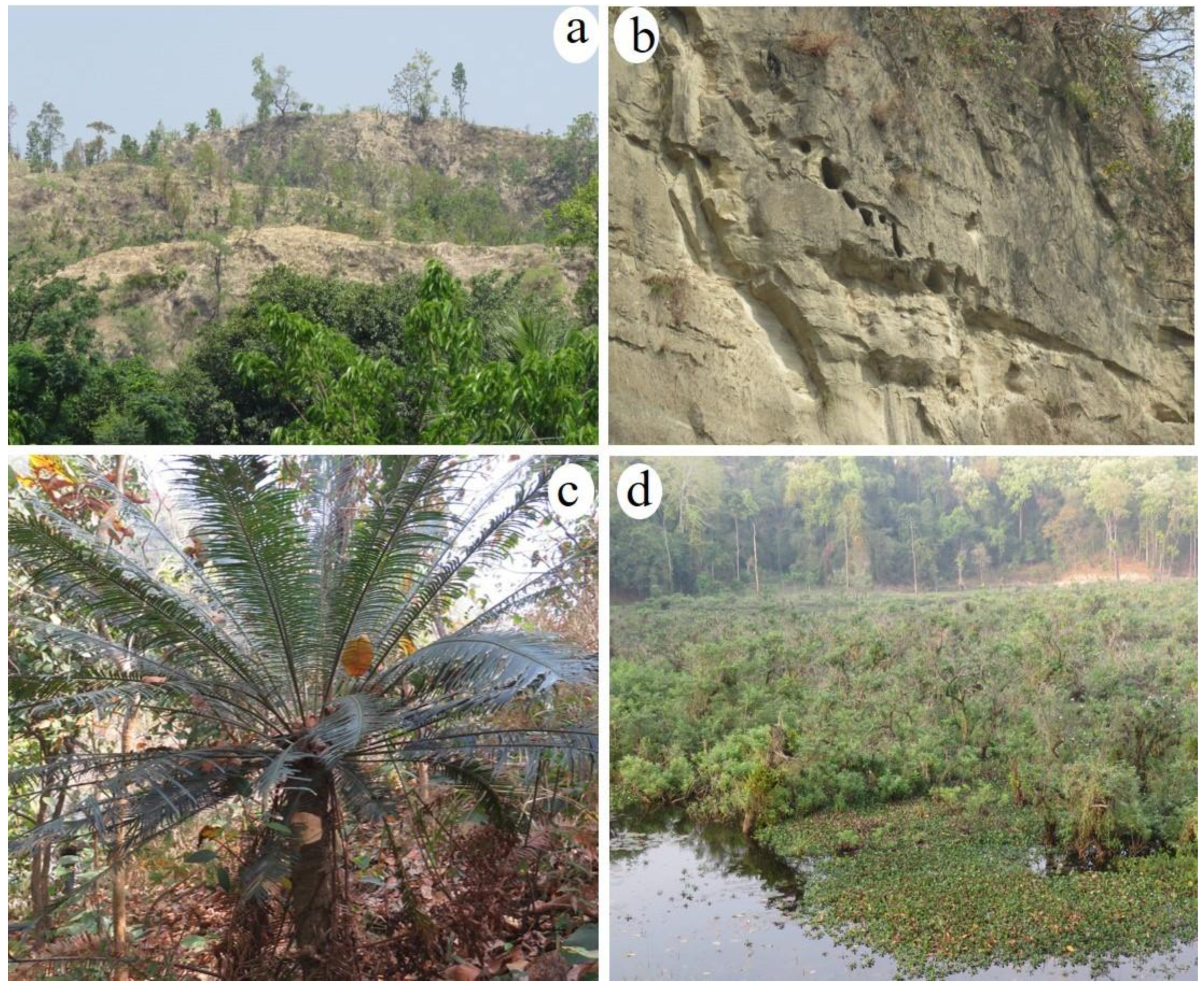
| 1 | Shorea robusta forest (Sal ban) (128–1110 m asl) ** | Kanchanpur (Daiji, Bedkot-1), Kailali (Syaule), Dang (Rapti, Bhalubang), Arghakhachi (Pirapani), Palpa (Bhutkhola, Dovan), Rupandehi (Debdaha), Nawalparasi (Daunee, Debchuli, Maulakalika), Tanahun (Pipaltar), Makwanpur (Jayasingh Manohari), Bara (Niggad), Sindhuli (Fulbari Marine Gaupalika, Maddovan, Marin, Ranibas, Kalapani), Mahottari (Tuteshor), Dhanusa (Bhatighari), Udayapur (Sundarpur), Sunsari (Latijoda), Ilam (Shikharkateri). | Trees: Shorea robusta, Terminalia alata, Aegle marmelos, Trewia nudiflora, Lagestroemia parviflora, Ziziphus mauritiana, Engelhardia spicata, Syzygium cumini, Mallotus philippensis Shrubs: Carissa carandas, Woodfordia fruticosa, Justicia adhatoda, Clerodendron viscosum, Cycas pectinata | Shorea robusta forms the pure forest at lower elevations and predominates the flat places from east to west, at 900 m to 1100 m elevations. Sal forest associates with Schima wallichii, another semi-deciduous species in Central and Eastern Nepal at around 1100 m. |
| 2 | Hymenodictyon excelsum forest (Latikarma ban) (270 m asl) ** | Morang | Trees: Hymenodictyon excelsum, Shorea robusta Shrubs: Murraya koenigii, Clerodendron viscosum | Pure stand of this species is found along the flood plains of Chure in eastern Nepal. |
| 3 | Syzygium cumini forest (Jamun ban) (186–237 m asl) * | Kailali (Masuriya), Karnali flood plain | Trees: Lagestroemia parviflora, Terminalia alata, Dalbergia sissoo Shrubs: Clerodendron viscosum, Colebrookea oppositifolia | Primary evergreen forest of Syzygium cumini is found in western Terai. It replaces Shorea robusta forest along the large riversides in moist and shady areas, Syzygium cumini is also one of the major associated species of other forest types- Shorea robusta forest, Terminalia forest, Terminalia anogeissiana forest. |
| 4 | Terminalia anogeissiana forest (Banjhi ban) (1073 m asl) * | Palpa (Majhuwa, Kanchakhola) Surkhet (Pokharikada) | Trees: Terminalia anogeissiana, Shorea robusta, Terminalia alata Shrubs: Woodfordia fruticosa, Maesa montana | The species occurs from Terai to about 1700 m, usually in Sal forest but it is also a common constituent of rather dry forest in the Chure, particularly in western Nepal, where it is sometimes dominant and form a distinct ecosystem. |
| 5 | Terminalia forest (Sajh ban) (386–468 m asl) *** | Kanchanpur (Salghad), Kailali (Godawari) | Trees: Terminalia alata, Terminalia chebula, Shorea robusta, Mallotus philippensis, Terminalia anogeissiana, Trichilla connaroides, Buchanania latifolia Shrubs: Woodfordia fruticosa, Justicia adhatoda, Colebrookea oppositifolia | These types of forests are often mixed with tropical Shorea robusta forest, but in some places they form the pure stand with more than 60 % coverage. Terminalia alata is the predominant species of this type. |
| 6 | Senegalia catechu forest (Khair ban) (134–185 m asl) **** | Sarlahi (Bagmati- 11, Lopchan Tol), Dhanusha (Bhatighari CF Puspabanpur), Siraha (Baba Tal, Bandipur-3) | Trees: Senegalia catechu, Albizia procera, Syzygium cumini, Mallotus philippensis, Azadirchata indica, Lagestroemia parviflora, Terminalia alata, Dalbergia latifolia, Bridelia retusa Shrubs: Murraya koenigii, Urena lobata | Mature secondary forest of these types is very much limited due to deforestation, however in some areas of eastern Nepal, primary forest of Senegalia catechu, can be observed associated with Dalbergia sissoo along the river banks. |
| 7 | Albizia forest (Siris ban) (144–700 m asl) ** | Sunsari (Chatara) | Trees: Albizia procera, Albizia lebbeck, Adina cordifolia, Cassia fistula, Alstonia scholaris, Wendlandia exserta Shrubs: Murraya koengii, Clerodendron viscosum | Albizia procera, a semi-deciduous tree and A. lebbeck occurs in dry open forest and at the Sal forest margins in Chure-Terai region of Central and Eastern Nepal. Albizia procera associates with Albizia julibrissin, Albizia chinensis and Erythrina stricta in south facing slopes of outer foothills at the edge of abandoned land terrace. |
| 8 | Dalbergia sissoo–Senegalia catechu forest (Sisoo–Khair ban) (195–346 m asl) *** | Dang (Lamahi), Kailali (Godawari, Malakheti, Geta, Shreepur) | Trees: Senegalia catechu, Terminalia alata, Dalbergia sissoo, Syzygium cumini, Aegle marmelos, Shorea robusta, Sapium insigne, Terminalia anogeissiana, Lagerstroemia parviflora Shrubs: Murraya koenigii, Randia spinosa, Urena lobata, Colebrookea oppositifolia | Forest as a discrete patch close to the river edge on newly formed gravels or midstream islands created by floods from Chure rivers. Forest types of Sisoo-Khair abundance of various heights, resulting in a discontinuous canopy with poor understory. |
| 9 | Tropical deciduous riverine forest (Usna Pradeshya Nadi Tatiye Pathjhar ban) (256–321 m asl) ** | Kailali (Godawori), Bardiya (Padanaha, Chepang), Ilam | Trees: Bombax ceiba, Tetrameles nudiflora, Sapium insigne, Holopetela integrifolia, Adina cordifolia, Terminalia alata, Dalbergia sissoo, Senegalia catechu. Shrubs: Murraya koengii, Colebrookea oppositifolia | It is found along the streams of Bhabar and Dun valleys. In west and central Nepal major component of this forest types are Bombax ceiba, Adina cordifolia and Sapium insigne, however in east Nepal the species composition is different, where the area is dominated by deciduous Tetrameles nudiflora and other associated species like Alangium salviifolium and Toona ciliata. |
| 10 | Tropical mixed broadleaved forest (Usna Pradeshiye Misrit Chaudapate ban) (151–1026 m asl) *** | Bara (3 no. Khola), Makawanpur (Gadhi), Morang (Thakaldada), Jhapa (Kankai), Ilam (Jorkalas), Kanchanpur (Daiji Bedkot, Libna), Kailali (Mohaniyal), Dang (Koilabash thulichaur, Suraikhola), Palpa (Majhuwa, Kanchakhola), Chitwan (Kuwapani, Shaktikhor) | Trees: Shorea robusta, Terminala alata, Terminalia chebula, Terminalia bellerica, Adina cordifolia, Semecarpus anacardium, Terminalia chebula, Cleistocalyx operculatus, Diploknema butyracea, Lagerstroemia parviflora, Litsea monopetala, Mallotus philippensis Shrubs: Murraya koengii, Woodfordia fruticosa, Phoenix humilis | These forest types are common from east to west where Sal alone cannot dominate the area entirely. This type of forest shows heterogeneous species distribution representing both tall and short trees with various canopy structures. They also offer a wide array of microhabitat conditions, therefore high species diversity and productivity in these forests are seen. |
| 11 | Schima wallichii–Shorea robusta forest (Chilaune-Sal ban) (665–730 m asl) ** | Ilam, Morang | Trees: Shorea robusta, Schima wallichii, Duabanga grandiflora, Terminalia alata, Lagestroemia parviflora, Syzygium cumini Shrubs: Woodfordia fruticosa, Colebrookea oppositifolia | Disturbed forest in the Chure region of Ilam, may Schima wallichii soon replace Shorea robusta if disturbances (mostly logging) continue. |
| 12 | Pinus roxburghii–Shorea robusta forest (Khote Sallo-Sal ban) (440 m asl) *** | Bara (3 no. Khola) | Trees: Shorea robusta, Pinus roxburghii, Semecarpus anacardium, Albizia lebbeck Shrubs: Woodfordia fruticosa, Inula cappa, Berberis asiatica | These types of associations are developing in Chure, Observed in Bara, and probably occurs also in Makwanpur. |
| 13 | Pinus roxburghii forest (Khote sallo ban) (435–1200 m asl) ** | Kailali (Khanidanda, Chure VDC), Kanchapur (Bedkot), Bara (3 no. Khola) Daldeldhura | Trees: Pinus roxburghii, Myrica esculenta, Quercus lanata, Semecarpus anacardium, Lagestroemia parviflora Shrubs: Rubus ellipticus Phoenix humilis, Berberis asiatica, Inula cappa | Pine forests are found in Chure region of western and Central Nepal in dry north facing slopes. It reduces the growth of other native tree species to its range by forming thick mat of fallen dwarf shoots on the ground. A Forest type is characterized by continuous canopy and very poor understory. |
| 14 | Bamboo thickets (Bans ban) (113 m asl) * | Siraha (Baba Tal) | Monospecific thickets; no other vegetation- ground is completely covered with the litter from the bamboos and there are no other shrubs, herbs, ferns or bryophytes. | Probably colonized after disturbance (landslide, forest fire); will be persisted for an unknown period until their dieback following flowering, which occurs at unknown intervals. |
| SN | Type of Ecosystem | Region | Reported in BPP Report (and Referred in Chure Master Plan) | Reported as New |
|---|---|---|---|---|
| 1 | Shorea robusta forest | East, Central, West | √ | |
| 2 | Hymenodictyon excelsum forest | East | √ | |
| 3 | Syzygium cumini forest | West | √ | |
| 4 | Terminalia anogeissiana forest | West | √ | |
| 5 | Terminalia forest | West | √ | |
| 6 | Senegalia catechu forest | East | √ | |
| 7 | Albizia forest | East | √ | |
| 8 | Dalbergia sissoo–Senegalia catechu forest | West | √ | |
| 9 | Tropical deciduous riverine forest | East and West | √ | |
| 10 | Tropical mixed broadleaved forest | East, Central, West | √ | |
| 11 | Schima wallichii–Shorea robusta forest | East | √ | |
| 12 | Pinus roxburghii–Shorea robusta forest | Central | √ | |
| 13 | Pinus roxburghii forest | Central, West | √ | |
| 14 | Bamboo thickets | East | √ |
| IPA Complex | Number of Site | District(s) |
|---|---|---|
| Lower Mahakali–Seti | 1 + 1 | Dadeldhura, Kanchanpur |
| Lower Bheri–Rapti | 2 | Salyan and Surkhet |
| Terai Arc Landscape | 8 | Kailali, Bardia, Banke, Dang, Palpa, Nawalparasi, Chitwan, Parsa |
| Rapti–Lumbini | 2 | Pyuthan and Argahkhanchi |
| Narayani | 2 | Makwanpur and Bara |
| Lower Janakpur | 2 + 1 | Sarlahi, Sindhuli, Dhanusa |
| Udayapur | 1 | Udayapur |
| Morang | 1 | Morang |
| Lower Kangchenjungha | 1 + 1 | Ilam, Jhapa |
| SN | Species | Category |
|---|---|---|
| 1 | Alstonia scholaris (L.) R.Br. | Rare (IUCN category) |
| 2 | Asparagus racemosus Willd. | Vulnerable (Conservation Assessment and Management Planning, CAMP *) |
| 3 | Bombax ceiba L. | Nationally protected (Under the National list of timber trees banned for felling, transportation or export) |
| 4 | Butea monosperma (Lam.) Kuntze | Endangered (IUCN category) |
| 5 | Choerospondias axillaris (Roxb.) B.L. Burtt & A.W. Hill | Rare (IUCN category) |
| 6 | Cinnamomum glaucescens (Nees.) B.L.Burtt & A.W.Hill | Protected |
| 7 | Crateva unilocularis Buch.-Ham. | Rare |
| 8 | Curculigo orchioides Gaertn. | Vulnerable (CAMP) |
| 9 | Cycas pectinata Griff. | CITES Appendix II; Endangered (IUCN category) |
| 10 | Dalbergia latifolia Roxb. | Nationally protected (Under the National list of timber trees banned for felling, transportation or export) |
| 11 | Dendrobium fimbriatum Hook. | CITES Appendix II |
| 12 | Dioscorea deltoidea Wall. Ex Griseb. | Commercially threatened |
| 13 | Magnolia champaca (L.) Baill. Ex Pierre | Endangered (IUCN category) |
| 14 | Gnetum montanum Markgr. | CITES Appendix III; Endangered (IUCN category) |
| 15 | Operculina turpethum (L.) Silva Manso | Endangered (CAMP) |
| 16 | Oroxylum indicum (L.) Kurz | Vulnerable (IUCN category) |
| 17 | Piper longum L. | Vulnerable (CAMP) |
| 18 | Pterocarpus marsupium Roxb. | Nationally protected (Under the National list of timber trees banned for felling, transportation or export) |
| 19 | Rauvolfia serpentina (L.) Benth. Ex Kurz | Endangered (IUCN category) |
| 20 | Rhynchostylis retusa (L.) Blume | CITES Appendix II |
| 21 | Rubia manjith Roxb. Ex Fleming | Vulnerable (CAMP) |
| 22 | Senegalia catechu (L.f.) Willd. | Threatened (IUCN category) |
| 23 | Shorea robusta Gaertn. | Nationally protected (Under the National list of timber trees banned for felling, transportation or export) |
| 24 | Swertia angustifolia Buch.-Ham. Ex D.Don | Endangered (CAMP) |
| 25 | Tinospora sinensis (Lour.) Merr. | Vulnerable (CAMP) |
| 26 | Vanda tessellata (Roxb.) Hook. ex G.Don | CITES Appendix II |
Disclaimer/Publisher’s Note: The statements, opinions and data contained in all publications are solely those of the individual author(s) and contributor(s) and not of MDPI and/or the editor(s). MDPI and/or the editor(s) disclaim responsibility for any injury to people or property resulting from any ideas, methods, instructions or products referred to in the content. |
© 2023 by the authors. Licensee MDPI, Basel, Switzerland. This article is an open access article distributed under the terms and conditions of the Creative Commons Attribution (CC BY) license (https://creativecommons.org/licenses/by/4.0/).
Share and Cite
Uprety, Y.; Tiwari, A.; Karki, S.; Chaudhary, A.; Yadav, R.K.P.; Giri, S.; Shrestha, S.; Paudyal, K.; Dhakal, M. Characterization of Forest Ecosystems in the Chure (Siwalik Hills) Landscape of Nepal Himalaya and Their Conservation Need. Forests 2023, 14, 100. https://doi.org/10.3390/f14010100
Uprety Y, Tiwari A, Karki S, Chaudhary A, Yadav RKP, Giri S, Shrestha S, Paudyal K, Dhakal M. Characterization of Forest Ecosystems in the Chure (Siwalik Hills) Landscape of Nepal Himalaya and Their Conservation Need. Forests. 2023; 14(1):100. https://doi.org/10.3390/f14010100
Chicago/Turabian StyleUprety, Yadav, Achyut Tiwari, Sangram Karki, Anil Chaudhary, Ram Kailash Prasad Yadav, Sushma Giri, Srijana Shrestha, Kiran Paudyal, and Maheshwar Dhakal. 2023. "Characterization of Forest Ecosystems in the Chure (Siwalik Hills) Landscape of Nepal Himalaya and Their Conservation Need" Forests 14, no. 1: 100. https://doi.org/10.3390/f14010100