
Integrating Ecosystem Services Valuation into Land Use Planning: Case of the Ukrainian Agricultural Landscapes


1
Department of Ecological Economics and Business, Ukrainian National Forestry University, Generala Chuprynky 103, 79057 Lviv, Ukraine
2
Department of Cadastre of Territory, Lviv Polytechnic National University, 79013 Lviv, Ukraine
3
Department of Land Management and Landscape Architecture, University of Agriculture in Krakow, ul. Balicka 253 C, 30-149 Kraków, Poland
4
Law and Engineering Company “Roxal”, Limited Liability Company, 21 Kleparivska Street, 79007 Lviv, Ukraine
*
Author to whom correspondence should be addressed.
Forests 2021, 12(11), 1465; https://doi.org/10.3390/f12111465
Submission received: 16 August 2021
/
Revised: 22 October 2021
/
Accepted: 23 October 2021
/
Published: 27 October 2021
(This article belongs to the Special Issue Political Ecology of Forests Ecosystem Services)
Abstract
:Modern agricultural landscapes produce multiple ecosystem services. Ecosystem services in agricultural landscapes have social, economic, and environmental value—providing a wide array of benefits to society. Absence of scientifically based and practically tested methodologies of identification, mapping, and evaluation of ecosystem services in agricultural landscapes hamper integration of its values in the current system of land use planning. The value of ecosystem services is calculated for the case study territory located within the administrative borders of Kolomak Territorial Community in Bohodukhiv district, Kharkiv region (Ukraine). The highest estimated value among non-market ecosystem services is carbon storage service, and among market services—food production. The baseline scenario of land use (business as usual) is compared with two alternative scenarios (Scenario 1. Land reclamation scenario; Scenario 2. Land protection and bioenergy production scenario). Designing of an integrated production system in the forest agro-landscape, which combines multiple ecosystem services, allows us to attain maximum results in terms of value. Amelioration of agricultural landscape through establishing a system of protective forest shelterbelts allows society to increase the total value of ecosystem services, and this is why it should be better integrated into land use planning and land management.
1. Introduction
Ecosystem services are defined as conditions and processes through which natural ecosystems and the species that make them up sustain and fulfill human life [1]. While informally judging ecosystem services can be useful in some situations, for its true potential as a tool for increasing long term sustainability they must be integrated into decision making in a systemic way [2]. It is critical that ES assessments reflect key decision-making levers and their consequences in the links between nature and people [3]. The biophysical models being used to quantify services from ecosystem, economic, and cultural models can be used to place value on the services—this information is then fed to institutions which then influence decisions through incentive provisions that provide feedback to the ecosystem [4].
Ecosystem services can be assessed from different perspectives. The first perspective determines the capacity of that ecosystem asset to produce ecosystem services and refers to the area of the land covered by an environmental asset (such as woodland). The second approach is to measure ecosystem assets in terms of expected ecosystem service flows. According to SEEA a particular combination, or ‘basket’, of ecosystem services will be generated at a particular point in time from a specific ecosystem asset. The aggregation of all future ecosystem services for a given basket provides, at a point in time, the estimated stock of expected ecosystem services flows [5]. An integrative approach is focused on the total asset value of the landscape (including both natural and human-made capital).
In recent years, knowledge of ecosystem services mainstream approaches to spatial planning has increased through research at different scales [6] and Geneletti et al. [7]. The adoption of an ES-based approach can overcome the traditional planning standards system [8].
As rates of deforestation and land degradation and losses of biodiversity and ecosystem services continue to rise globally, the international community is faced with the challenge of finding land use interventions that can mitigate or reduce the impact of these environmental issues. In particular, during the few last decades, there has been a growing interest in agroforestry because of its biodiversity and the ecosystem services it delivers [9].
In Ukrainian history, there is a wealth of experiences of afforestation, forest melioration of agricultural areas for reasons which we could consider nowadays as aimed at supporting the flow of multiple ecosystem services. The first afforestation activities in Ukraine date back to the 17th century when the Cossacks planted in Zaporizhska Sich forest land and also planted fruit trees on the Dnipro islands (Khortytsya, Monastyrskyy, and Demekoviy) and in other places [10]. They planted oaks for shipbuilding, as well as other trees along the lines of fortifications as a defense measure. Peasants and colonists during settling of the steppe regions also carried out afforestation. According to a government decree, tree planting was one of the obligations for everyone in a colonist community. Additionally, new settlers planted trees hoping to get building material and fuel wood in this almost non-forested region. For example, on the marginal lands of Myrgorod district, Poltava region, landlord I. Ya. Lomykovsky created (in 1809–1837) the whole system of shelterbelts, which ensured conditions for obtaining high and stable harvests [11].
After the Second World War (1945), afforestation operations were considerably intensified. Shelterbelt afforestation achieved a high scientific and technical level in the Ukraine after 1948, when the programs of the shelterbelts planting in the steppe were carried out on a large scale (the so-called Plan of Nature Remaking). Gradually, all the harvested areas were reforested and low-production agricultural lands were partially afforested to protect land from wind and water erosion. The highest level of afforestation was reached in 1971–1975 when 199 thousand ha of forest stands (at ravines, sands, etc.) and of 82 thousand ha of shelterbelts were planted [12]. During the following years, the planted areas slowly decreased because of hanging state priorities. Later, in the 1990s, they decreased further as a consequence of the land reforms in the framework of transitional processes in the economy.
At the same time, it is worth mentioning that a new ambitious program of afforestation, “The Green Country”, has been recently declared by the President of Ukraine and the government. The program aims to increase the country’s forested area by 1 million hectares over 10 years [13] which may create more favorable preconditions for protective forest amelioration of agricultural landscapes.
The main aims of this study were: (1) to estimate the value of market and non-market ecosystem services of the typical area of agricultural landscapes of the Forest Steppe zone in the conditions of Ukraine which integrate the system of forest shelterbelts; (2) to identify the challenges and prospects of ecosystem services value integration into current land–use decision-making processes.
2. Conceptual Framework
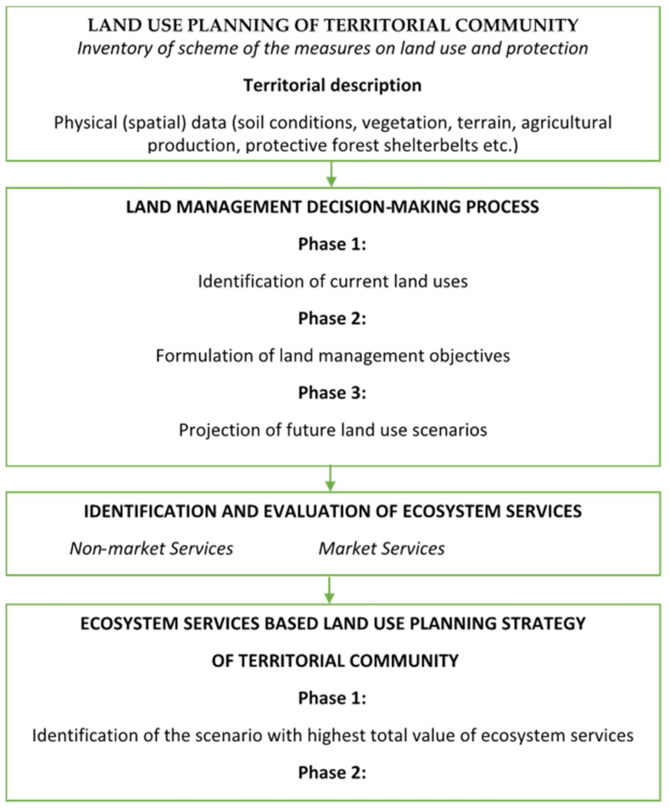
The scientific research describes the process of integrating ecosystem services values under alternative management scenarios in land use planning. The proposed algorithm includes four steps, containing one or more procedures in each step (Figure 1).
At the first stage, preparatory work is carried out—collection, systematization and analysis of materials characterizing the natural and socio-economic conditions of the object of study, as well as project decisions for future development of land resources and land protection.
Materials of the land inventory, data of field surveying of the territory, and the Public Cadaster Map of Ukraine were used as sources of information about land use and land cover conditions.
The collected data will be used to substantiate the land management decision, which will include calculations, descriptions, and drawings of technical solutions, the implementation of which is expected to be implemented under the working land management projects.
The next step is to assess the value of ecosystem services for non-market and market services. The information required to identify key ecosystem services is collected through a combination of literature review, data analysis, and expert consultation.
The final stage of the study is the identification of the scenario with the highest total value of ecosystem services as a direction for implementation of land use planning strategy of the territorial community.
3. Materials and Methods
3.1. Study Area
Kharkiv region has the biggest area and highest bio-productive potential of the land fund among the administrative regions of Ukraine. The share of agricultural lands exceeds 77% in the land fund structure. The share of arable land is almost 62% of the structure of agricultural lands [14].
The Kolomak community area is 329.5 km2, which makes 1.05% of the territory of Kharkiv region. The community is located in the forest steppe zone. The location is characterized by hills and lowlands, with slope to the south and is segmented by gullies and ravines. Kolomak community is rich in fertile black soils ‘chornozem’, clay, sand, gas deposits, and water resources.
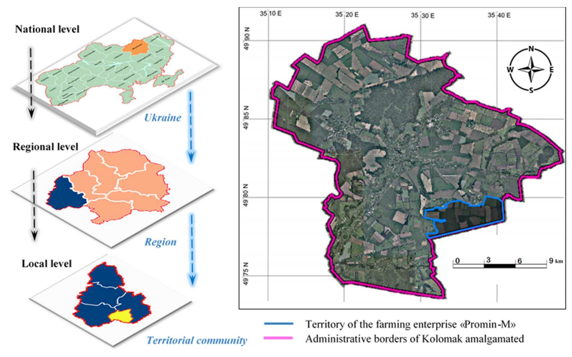
The territory of the farming enterprise ‘Promin-M’ that is located within the administrative borders of Kolomak Territorial Community in Bohodukhiv district, Kharkiv region (Ukraine) served as a case study (Figure 2).
Water and wind soil erosion is one of the main destabilizing factors causing reduction of the agricultural land productivity and aggravating the environmental situation in agricultural landscapes of the farming enterprise. Generally, in Ukraine, such problems are caused by land use, which does not contribute to the optimal parameters of ecological and social-economic functions of the territory, lack of system melioration, and anti-erosion measures on the arable lands [16]. The insufficiently supported land reform did not secure an adequate organizational and technological approach to employment of productive, low-productive, degraded, slope, and meliorated lands—resulting in negative effects on sustainability of agricultural landscapes. Consequently, soils have lost a considerable share of humus, the most fertile black land soils have been transformed into soils with medium fertility, and the process is getting worse [17].
The community’s economic development is based on agriculture: 76% of the community lands are used for agriculture, including the area of arable lands—22,045 ha (88.0%), grasslands 784 ha (3.1%), forest shelterbelts and other green areas—379 ha (1.5%).
The community territory provides opportunities for operation of some large agricultural producers and small farms that create a favorable competitive environment. The farming enterprise ‘Promin-M’ has been operating since 2000. It specializes in growing cereals (winter and spring wheat, winter rye, winter and spring barley), legumes, and oil seeds. The land resources of the enterprise include such main land use types as arable land—1338.6 ha, grassland—43.2 ha and forest shelterbelts—8.4 ha. The land use management based on such a structure of land use is considered in this study as a baseline scenario. Besides that, we considered and calculated the value of ecosystem services for two alternative scenarios:
- Scenario 1. Land reclamation scenario—transformation of arable land to meadows and forest shelterbelts
- Scenario 2. Land protection and bioenergy production scenario.
Both scenarios are described, analyzed, and compared with a baseline scenario in Results.
3.2. Methodology of Complex Land Use Planning
A complex plan of the spatial development of the territorial community area is also a city- planning documentation of the local level and documentation of land organization, which outlines the planning organization, functional use of the territory, main principles, and directions of formation of a common system of public servicing for the population, road network, engineering and transport infrastructure, engineering preparation and providing of public services and utilities, civil defense of the territory and population from dangerous natural and anthropogenic processes, land protection and other components of the natural environment, formation of ecological networks, protection of the cultural heritage and traditional character of the settlement environment, as well as a sequence of a projected solution, including phasing of the territory’s projected development [18].
The complex approach to regulation of the land relations at new territorial communities suggests development of the following planning and cartographic materials:
- Scheme of the modern land use;
- Scheme of the regime-forming objects and restrictions on land use;
- Scheme of the planned measures on rational use and protection of lands;
- Scheme of the prospective use of lands and organization of the community territory;
- Participative scheme of territory planning that includes involvement of the community authorities.
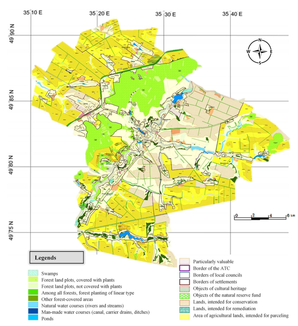
The complex plan provides a clear idea about the community resources, their distribution, and prospects for its future development. For the community, the most definite issue is to make a correct determination of its borders, as well as planning, use and protection of lands within the territory borders, particularly while delegating the authorities to manage land resources outside the settlements extending to the remaining communities. Within the Kolomak amalgamated territories community in Bohodukhiv district of Kharkiv region, the complex plan outlines the prospective use of lands and restrictions on their use, and specifies measures concerning rational use and protection of lands (Figure 3).
The complex spatial plan of the community territory identifies:
- Land area intended for remediation and conservation;
- Land plots, which cannot be used for arable farming because they are located on the slopes above 5°;
- Forest belts that actually perform the function of forest amelioration on the territory;
- Natural territories for creation of new objects of the natural reserve fund;
- Objects of cultural heritage.
Land restoration aimed at recovery of the appropriate conditions of agricultural lands on marginal degraded lands within the community borders is planned to be done by means of further meadows restoration and afforestation. On the slopes from 5° to 15° grade with the washed out soils, it is planned to introduce soils protecting crop rotations including perennial herbs, cereals, and a limited amount of inter-tilled crops (maize, potato, sunflower).
To protect biodiversity and ecosystem services, protected areas could be established as this is still one of the most effective mechanisms in the process of protection of the natural ecosystems, unique natural territories, landscapes, and rare species of plants and animals.
3.3. Methodology for Valuing Ecosystem Services
Ecosystem services could be identified and evaluated in terms of an integrated production system in the landscape as the supply of food, energy, and ecosystem services at the same time [20]. It has been well recognized that these services and benefits provided by agroforestry practices occur over a range of spatial and temporal scales (Table 1) [21]. In this study, the ecosystem services evaluation covered the levels of landscape, including farm, first of all those who are the most relevant for local community level.
We consider forest melioration as working in agricultural areas by creating a system of forest shelterbelts and other protective forest stands as a quite successful form of agroforestry system well adopted to forest steppe and steppe conditions of Ukraine. According to preliminary estimates, the total value of ecosystem services provided by protective forest belts in Ukraine is about 39.8 billion Ukrainian Hryvnia (UAH)/year [22]. Ecosystem functions of shelterbelts as components of agroecosystems are integral parts of the ecosystem processes that occur here and produce substantial list of ecosystem services: at least 23 ecosystem functions and 55 ecosystem services identified [23]. In particular, the value of oxygen emitted by forest shelterbelts is 16.7 billion UAH per year, impact on soil protection from degradation provides about 5.7 billion UAH/year, and the value of increasing agricultural production under shelterbelt protection is 17.3 billion UAH/year [22].
Our attempts were to evaluate the main ecosystem services at the local level of the study area, except for some of them, due to the lack of limited information. Each of the selected services were evaluated for four categories: arable land for crops, pastures, bioenergy plantations, and field protection forest shelterbelts.
Ecosystems provide a combination of services that are traded on markets such as timber or grain (market ecosystem services—ESmarket) as well as services that cannot be sold in markets (non-market ecosystem services—ESnon-market) such as nitrogen regulation or soil formation. The economic value of market ecosystem services is well known and is reflected in market prices whereas the economic value of non-market ecosystem services is not well known and research is often required to estimate their value [24].
The total economic value (EStotal) of the selected ecosystem services calculated by summing of all non-market (ESnon-market) and market (ESmarket) values for each category [25].
—total economic value of the selected ecosystem services;
ESnon-market—non-market ecosystem services;
ESmarket—market ecosystem services.
ESnon-market = ES1 + ES2 + ES3 + ES6 + ES7 + ES8,
ES1—biological control of pests service;
ES2—nitrogen (N) regulation service; ES3—soil formation service; ES6—carbon accumulation service; ES7—hydrological flow service; ES8—pollination service.
ESmarket = ES4 + ES5,
ES4—food and feed production service;
ES5—biomass raw material production service.
All calculations were performed on the basis of several data obtained from different sources. Economic value of each service was calculated in Ukrainian hryvnia UAH (average currency rate 1EUR ≈ 32 UAH [26]).
3.3.1. Biological Control of Pests Service (ES1)
The economic value of biological pest control service was evaluated using the method of unification of costs from the use of pesticides for agricultural land. Protective forest shelterbelts are the habitat of most common species of entomophagous organisms, which are able to limit the number of pests of agricultural crops. The population of insects at the forest belt edge is 31–48% higher than in the middle of the forest strip. Analysis of the distribution of entomofauna revealed 7-times more phytophages in the field compared to the number of these insects in the forest belt. At the same time, the number of entomophages was 1.7-times higher in the forest belt. Estimation of the ratio of phytophages and entomophages near the edge of the forest belt creates conditions for natural control over the number of pest populations and adjustment of chemical treatment of the field [23].
In the calculations, we assumed that 1 ha of protective forest belts, considering their current state (construction, assessment and forest reclamation indicators), provided protection for up to 15 ha of arable lands [27]. Based on this ratio, we calculated the area of agricultural land on which natural pest control takes place and the cost of this ecosystem service by avoiding the costs of chemical treatment. Based on the price of the most common pesticides in use in Ukraine (Actellic 500EC and Basudin 600 EC) and the consumption rates of these pesticides per hectare, the economic cost of this ecosystem service is calculated for each land use scenario.
3.3.2. Nitrogen (N) Regulation Service (ES2)
The method of economic evaluation of nitrogen regulation takes into account the assimilation of nitrogen compounds from the air, which uses microorganisms and plants [28].
Chemical elements, fixed in the leaves of trees and partly in the ground cover, are actively involved in the biological cycle. Thus, with leaves, due to metabolic processes and the activity of fauna, 4–40% of chemical elements are carried to the fields nearby. This return of chemical elements in the forest-steppe and steppe plantations is 340–580 kg ha−1 [23]. Complete fixation of nitrogen in microorganisms and plants is: on pastures—690 kg per 1 ha, arable land—345 kg per 1 ha, bioenergy plantations—24 kg per 1 ha of plantations [25]. In forest ecosystems (forest belts are projected in our both scenarios), complete fixation of nitrogen is an average of 10 kg of nitrogen per 1 ha per year [29].
This estimation assumes that, if there is no soil N, then we would have to provide this amount of N to maintain productivity [25].
The total economic value of this ecosystem service is calculated taking into account the average commercial price of UAH 17.5 per kilogram of nitrogen fertilizers in Ukraine [30].
3.3.3. Soil Formation (ES3)
Soil formation is considered to be closely related to the activity of earthworms, so it depends on the density of earthworms. The economic value of the role of earthworms in soil formation was calculated based on data that the average earthworm biomass is 0.2 g and that one ton of earthworms forms one ton of soil per hectare per year [25].
The average number of worms is: on pastures and bioenergy plantations—5 million per 1 ha; on agricultural lands—2 million per 1 ha [31]. Thus, worms produce 1000 kg of soil per hectare on pastures and 400 kg on agricultural lands. Taking chernozemic soil as a basis, its specific weight in 1 m3 [32] and the average commercial price of 350 UAH t−1, we can determine that the economic value of this non-market ecosystem service is 350 UAH ha−1 y−1 for pastures and bioenergy plantations, and 170 UAH ha−1 y−1 for agricultural crops.
Protective forest belts have a positive effect on the biotic factors of the soil cover which are adjacent to them directly. Thus, forest belts at a distance of up to 10 heights contribute to the formation of stronger soil horizons, increasing the humus content by 20–40% and soil porosity up to 9%. The increase of humus in the layer of 0–50 cm under 42-year-old protective forest belts is 14.79 t ha−1 [23].
3.3.4. Food and Feed Production (ES4)
This ecosystem service belongs to the market services, so its economic value depends and is calculated directly on the yield of a culture and market prices. Grain yield on agricultural land under the existing method of land use is 49.8 quintals per hectare [33]. With the implementation of the optimal area of protective forest belts for the study area, grain yield will increase by 15 percent [34] and will be 57.2 quintals per hectare.
According to data for July 2020, the average purchase price for wheat of the third class in Ukraine is 6516 UAH per 1 ton [35]. Thus, the total value of this market ecosystem service is UAH 32,449.68 ha−1. The average yield of meadow grasslands of the forest-steppe in Ukraine is 72.6 quintals per hectare [36]. According to the portal Agro-Ukraine data, the price for 1 ton of hay is on average UAH 2400. Thus, the economic value of this ecosystem service for pastures is 17,424 UAH ha−1.
Forest belts are also a producer of food such as mushrooms, berries, etc. However, given the specifics of our calculations and the lack of a clear methodology, the situation does not allow us to take into account these opportunities and quantify them in monetary terms.
3.3.5. Biomass Raw Material Production (ES5)
This type of service also refers to the market services, applies and is calculated exclusively for the area set for bioenergy plantations. According to an analytical study prepared by the Economic Development Agency PPV Knowledge Networks in 2018 under the European Union Technical Assistance Project “Biomass Energy: Transforming Natural Potential into Regional Partnerships”, to obtain 1 Gcal of heat you need to burn an average of 1.8–2.2 m3 of wood chips, depending on its humidity and outside temperature [37]. Compared to gas, it is about 40% cheaper. The yield of the most common energy crops such as willow, poplar and miscanthus averages 15 tons per hectare [38]. According to the UABIO portal (https://uabio.org/, accessed on 20 June 2021), the average price of biomass is UAH 1500 ton−1.
3.3.6. Carbon Accumulation (ES6)
The methodology for estimating this ecosystem service in general is to calculate the amount of carbon consumed by each type of land use and the cost of carbon emissions quotas on the world market.
Carbon fixation is the general name for a series of processes in which carbon dioxide CO2 is converted into organic compounds. For arable land and pastures, our study is based on the assertion that 40% of the mass of plant and root residues is carbon absorbed from the atmosphere [25]. According to the portal Agrobusiness Today, on average, the mass of plant and root residues of cereals is 2.5 t ha−1, the mass of root residues of perennial grasses of meadows and pastures is 5 t ha−1 [38]. Thus, the total amount of carbon fixation on agricultural lands and pastures is 1 t and 1.6 t per hectare, respectively.
As for bioenergy plantations, during the growing season bioenergy plants, such as paulownia, grow very quickly and have a significant area of carbon dioxide absorption of CO2 and oxygen release. One tree can absorb an average of 22 kg of carbon dioxide per hour, and one hectare of bioenergy plantation absorbs on average more than 200 tons of CO2 in three years (analytical study data prepared by the European Union Technical Assistance Project “Biomass energy: transformation of natural potential into regional partnerships”) [39].
In forest belts, mixed stands with developed undergrowth deposit on average 0.6–1.1 t ha−1 of carbon [23]. According to the Mind© internet portal (https://mind.ua/, accessed on 20 June 2021), carbon futures in the region in two years have doubled to more than 55 EUR with the expectations of stronger climate goals reforms.
Thus, the economic value of this ecosystem service in the study area will be: for agricultural land 1793 UAH t−1, for meadows and pastures 2868.80 UAH t−1, for bioenergy plantations 119,533.33 UAH t−1, and for forest belts 1524.05 UAH t−1.
3.3.7. Hydrological Flow (ES7)
The method of calculating this service takes into account the average annual rainfall in the region, the structure of the agricultural landscape, the impact of existing and planned protective forest belts on the natural soil moisture and estimated it by equating it to the cost of water for irrigation purchased by farmers [40].
Forest shelterbelts reduce water evaporation from the soil surface. In particular, the reduction of wind speed in the system with forest belts reduces moisture evaporation by 20–30%, and snow retention contributes to additional moisture of the forest-steppe soils by an average of 25–30 mm [41].
The average annual rainfall in the region with the study area is 540 mm. According to the Agravery News Agency [42], on average in Ukraine, farmers pay 1.2 UAH per cubic meter for water for irrigation.
Taking into account all the adjusted indicators of natural soil moisture, the cost of this ecosystem service is approximately UAH 9 million annually in the existing land use system and approximately UAH 14.5 million in our proposed scenarios using field protection forest belts.
3.3.8. Pollination (ES8)
The economic value of this ecosystem service was assessed using a method which avoids the direct cost of purchasing (renting) beehives/families for the pollination period [25]. This type of commercial cooperation between farmers and beekeepers is very popular all over the world. Well-pollinated crops give more products of better quality and more attractive to the consumer. From one to eight families of honey bees should be placed on one hectare of insect pollinating plants [43]. For example, one hectare of rapeseed rape needs four bee colonies or twice as many lone (wild) bees. To pollinate one hectare of garden, either two families (20–70 thousand individuals) of honey bees or 530 females of osmium (wild bee) are needed. If the area contributes to the habitat of a sufficient number of specialized wild pollinators, then there is no need for additional pollination by honey bees [43].
We consider the study area comprehensively as a combined system, which includes arable land, pastures, bioenergy plantations, and forest belts. The last three systems are the natural habitat of wild pollinators. Therefore, there is no need to separately purchase or rent honey bee hives. The cost of renting a bee family for the flowering period averaged UAH 550 [44]. Thus, the cost of this service is estimated based on the average number of wild pollinators, their productivity, and the relative cost of renting the appropriate quantity (average of five) of bee colonies per one hectare, which is 2750 UAH both for a hectare of pastures and for a hectare of bioenergy plantations and forest belts.
4. Results
4.1. Land Use Planning Scenarios
Whether considering traditional land use planning, or variations such as spatial planning, the challenge for land use planning is to ensure the efficient use of limited land resources, and to contribute to sustainable economic development (at the regional, national, and local levels), as well as to safeguard the balanced use of resources (e.g., soil, water, and biodiversity) [45].
In Ukraine, the priorities of sustainable land use at local level are implemented by developing complex plans of spatial development of the territorial community area and the projects of organization of the territory of land possessions and land uses.
Land management at the community level should, therefore, be closely integrated with spatial planning, environmental protection, agriculture, and social policy. It should also consider other factors which directly or indirectly affect the landscape [46].
Therefore, the complex plan of spatial planning of the community territory development is implemented step-by-step by completing the land management projects of organization of the territory of some land holdings and land uses that expects creation of forest planting, conservation of low-productive and degraded lands, remediation of the disturbed lands and other measures.
At the farming enterprise ‘Promin-M’, the expected plans can be achieved through the alternative scenarios of land use. The approved planning suggests development of several rational and the most probable variants of the land use development. However, implementation of the measures for land organization according to each scenario is impossible without consideration of the productive and territorial peculiarities of the land (soil fertility, humidity conditions, erosional features, and land clearance conditions).
The baseline (current) scenario of the enterprise land use on the community territory is characterized by the following structure, namely arable lands (barley, wheat)—1338. 9 ha (96.3%), grassland—43.2 ha (3.1%), forest protection planting—8.4 ha (0.6%).
It is confirmed that the current conditions of agricultural land use within the studied object do not meet the requirements of rational and ecologically substantiated use. Therefore, it is expedient to develop a complex of measures, focused on improvement of land conditions by using soil-protecting land transformations.
Analysis of the soil cover of the studied object confirms its diversity. According to the materials from soil observation, the dominating soils within the farming enterprise are presented by typical low-humus black soil and heavy-degraded loamy black soils (54.6%), a considerable share of the territory (22.7%) is presented by heavy-eroded soils. The land use topography is characterized by wavy lands, and slopes of ravines are short and up to 7°. Particular attention within the borders of the examined territory should be paid to the forest shelter plantings.
The land use planning for farming enterprises is based on the topographic and ecological approach that concerns the territory being sensitive to water and wind erosion and suggests scenarios of its use. The topographic and ecological planning is completed based on the map charts of steepness and length of the slopes of arable lands, and map charts of agro-productive groups of soils.
Using this information, different land use scenarios can be developed, and the best option selected, taking into account criteria of sustainable land use.
It is determined that having withdrawn the heavy-eroded soils from agricultural use, it is expedient to implement two scenarios of land use in the conditions of the farming enterprise ‘Promin-M’:
- Land reclamation scenario transformation of arable land to meadows and forest shelterbelts;
- Land protection and bioenergy production scenario.
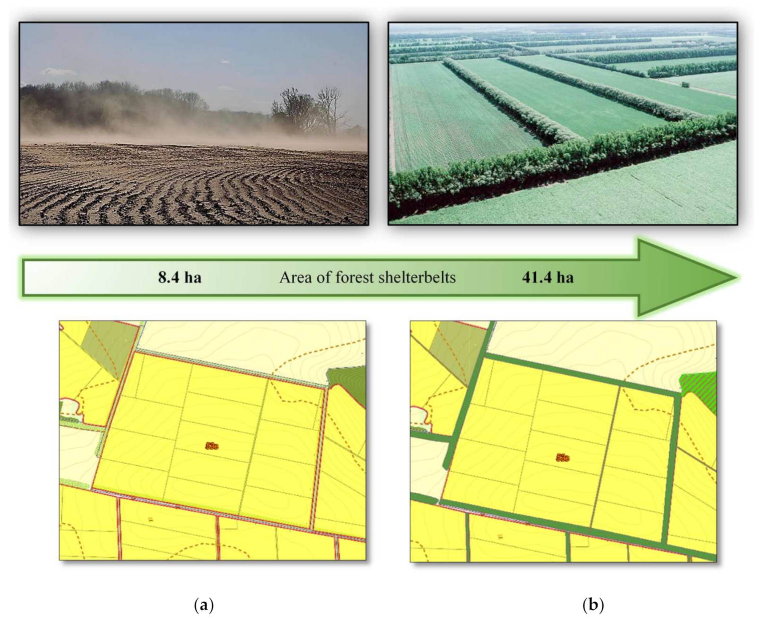
Both scenarios suggest projecting of forest shelterbelts that will secure economically efficient agroforestry regime of land use with protection of the ecological function (Figure 4).
The suggested system of forest shelterbelts will separate out the arable lands, performing the climate-regulating, soil-protecting, and water-protecting function. Moreover, such a solution will increase the yield of cereals by 15–20% [49].
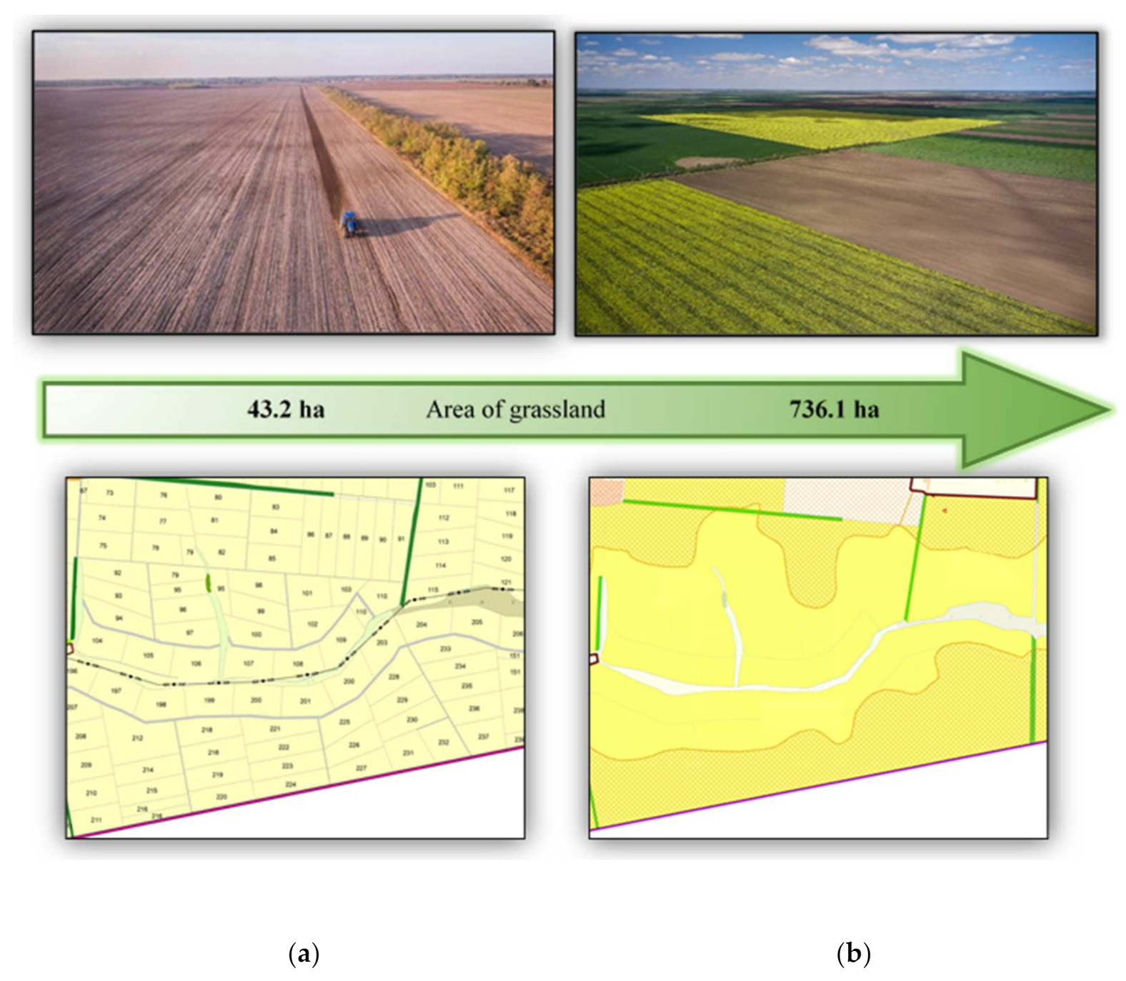
According to the first scenario, the degraded low-productive lands are planned to be used for grassing (Figure 5).
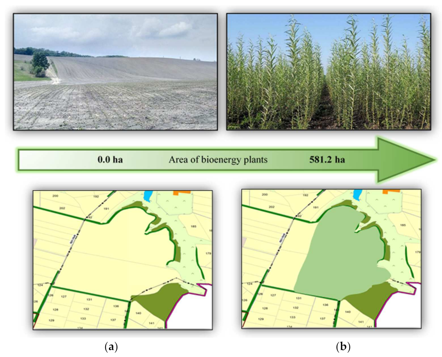
However, the second scenario of land protection and bioenergy production will provide the opportunity to use the territory for growing bioenergy plants (willow) (Figure 6).
The alternative scenarios include measures based on nature-based solutions (NBSs) which form a cost-effective long term solution for mitigating and restoring land affected by degradation processes. NBSs can be divided into two main groups: soil solutions and landscape solutions [50]. Proposed scenarios include soil solutions (soil health and soil functions will be supported by grasslands restoration instead of degraded arable lands) and landscape solutions (minimizing erosion problems and creating favorable microclimate conditions for big agricultural areas by creating the system of protective forest shelterbelts).
Table 2 demonstrates figures of the land area redistribution within the farming enterprise territory referring to the approved scenarios of land use.
4.2. Ecosystem Services Value under Alternative Scenarios
The summarized results of ecosystem services evaluation in the context of land use structure and proposed scenarios are presented in Table 3, Table 4 and Table 5.
Analysis of calculations and the share of each type of assessed ecosystem services in the total value of all selected services shows that non-market services, despite the imperfection and generalization of assessment methods, have the dominant share compared to market services. With the existing baseline scenario mainly focused on the arable land use, market services account for only about one-sixth of the cost of all services. In general, the value of market services (UAH 44,202.20) and non-market services (UAH 206,409.06) shows us the approximate ratio as being 1:5. Among non-market services, the dominant service is nitrogen fixation as one of the important biological processes in the biosphere, which is equated to photosynthesis and mineralization of organic residues, which play an important role in providing plants with nutrients.
The total economic value of the ecosystem services of the selected study area under the existing land use structure is a little more than UAH 250 million for a year.
Analysis of calculations according to a land reclamation scenario (increased area of pastures, meadows, and protective forest shelterbelts) shows that with a comprehensive approach to the land use planning of the study area (introduction of protective forest shelterbelts and conversion of agricultural lands to meadows and pastures) the value of ecosystem services significantly increases with a slight decrease in the cost of traditional market services from about UAH 44 million to UAH 33 million.
However, the cost of non-market ecosystem services increases from approximately UAH 206 million to nearly UAH 450 million—i.e., twice as much as the corresponding value of services of the existing land use structure.
At the same time, due to the increase in the area allotted for meadows and pastures, the cost of soil formation services increases, which together with the nitrogen fixation service occupies about 90% of the total cost of ecosystem services.
The results of calculations under a land protection and bioenergy production scenario, which also envisages a reduction of agricultural land compared to a land reclamation scenario, but the introduction of bioenergy plantations and protective forest belts, shows a slight difference in the total cost of ecosystem services—more than 438 million UAH. Under this structure of land use, again, a huge role in the provision of ecosystem services is played by the established forest shelterbelts. With such a structure of land use, there is also a slight decrease in the total value of market services and a significant increase, almost twice, from 206 million to 400 million UAH of the value of non-market ecosystem services.
Thus, due to balanced multifunctional land use an integrated production system in the forest agro-landscape, which combines food and feed supply, biomass energy, and other ecosystem services, this allows society to achieve the maximum ecological and economic effects at the same time.
5. Discussion
The understanding of agroforestry systems, that involve a greater diversity and complexity than conventional agricultural and forest systems, has become a research interest world-wide. Despite the great differences in social, economic and political situations throughout the world, fundamental aspects concerning the way agroforestry practices modify basic ecological and sociological processes are common in many land use systems [55].
In Ukraine, such agroforestry practice is represented by the process of forest amelioration of agricultural landscape through establishing the system of protective forest shelterbelts, mainly in Forest Steppe and Steppe zones. According to the data of the Research Institute of Forestry and Forest Melioration named after G. M. Vysotsky, nowadays there are almost 1.2 million ha of forest protective stands, including 440 thousand ha of forest shelterbelts inside the areas of agricultural enterprises in Ukraine. [56].
However, despite the reach of traditions of ameliorative afforestation and technological silvicultural achievements in this field during the last few decades, institutional gaps created a huge challenge for maintaining forest shelterbelts and other forest protective stands in agricultural areas. Parceling of land area as a consequence of land reform and the emergence of a great number of low-efficiency farms have brought about negative consequences in the system of land use [17].
The inconsistent land reform has resulted in total neglect of protection and reclamation of shelterbelts that has caused their destruction and loss of their protection function. Nowadays, all forest belts on the community territory do not have any legal status, and the functions of their maintenance and protection are performed by the community and land users. In some places, forest belts have become places for garbage dumps and landfills for waste of industrial and agricultural enterprises, a ground for weeds. With no legal owners, forest belts are largely logged by local population for personal needs, and suffer from fires when dry plants are burned on hayfields and grassland in spring and autumn periods. Lack of forest control for protection of plants causes their agroforestry functions and therefore, the yield of agricultural crops, to decline, and water and wind erosion of the field soil is aggravated.
Additionally, from the early 1990s until 2019, land plots intended for forest shelterbelts which were planned within development of the regional schemes and projects of land organization of collective agricultural enterprises were left without an owners, and consequently were illegally harvested and degraded causing extension of soil erosion and worsening of environmental conditions.
Some positive changes were accomplished in 2018 by introducing amendments to legislative acts. In particular, it was confirmed that land plots used as forest shelterbelts can be entrusted for permanent use by the state or public specialized enterprises, or for lease by physical and juridical persons with the mandatory specification in the lease agreement about what the conditions of maintenance and protection of such belts are and how the function of agroforestry melioration by them is fulfilled [57].
Therefore, new forest shelterbelts should be created or restored to complete the system of protection forest plantings on the corresponding territories according to the “Rules of forest reclamation” [58] by means of forest planting on:
- Degraded and marginal agricultural lands, which are submitted to conservation by means of reforestation;
- Lands which are unsuitable for agricultural use (gullies, ravines, steep slopes, rocky land, sand);
- Remediated lands, valleys, and wastelands;
- Lands of agricultural and other intended use, determined for forest plantings of a linear type (forest shelterbelts, belts along the river-sides, borders of canals, water bodies, railways, motor ways).
To implement the defined measures, some amendments were introduced to the Land Code of Ukraine and other legislative acts in July 2020 concerning land use planning, which identify new approaches to development of planning documentation of the territorial communities.
Increasing tree cover on agricultural land is a way to enhance ecosystem services through different strategies [59]. This idea can be better accepted by society if the value of the basket of ecosystem services is estimated and communicated with stakeholders.
6. Conclusions
We conclude that assessment of the set of ecosystem services provided by forest shelterbelts, bioenergy plantations, and agricultural lands is an important precondition for making sound decisions in the field of land use planning. The assessment of the forest shelterbelts benefits—in terms of their economic value—is of particular importance as the underestimation of the value of natural resources and ecosystem services in general is one of the causes of ecosystems and their services degradation and neglect. The establishment, maintenance, and operation of protective forest shelterbelts as an element of the system of protective ameliorative forest stands in the agro-landscape contributes to a wide range of ecosystem services delivered by the agro-landscape.
Ecosystem services assessment has become a highly topical research problem—including its identification, classification, mapping, and evaluation. The economic approach to ecosystem services may represent an effective tool to include conservation related issues in land-use planning [60]. However, institutional gaps and lack of information on ecosystem services values at a local level still restricts integrating ecosystem services into land use decision-making processes. Therefore, integrating future ecosystem services analysis into the spatial planning policies is critical [61,62]. The National Action Plan for Environmental Protection until 2025 includes point 64: “Introduction of modern methods of systematic informing of all segments of the population, and especially—territorial communities, about value of territories and objects of nature reserve fund, ecosystem services which they render” [63], but unfortunately it does not include the actions towards ecosystem services identification, mapping, and evaluation. Meanwhile, developing alternative land use scenarios with estimated value of ecosystem services is an important precondition for integrating the ecosystem services consideration into sustainable land use planning and land governance and management processes.
Finally, the limitations of this study are as follows: the first is the limitation of data, which is essential for such a study. We also lacked the data necessary to make evaluations of cultural services of landscape enriched with forest shelterbelts and other protective forest stands. Second, the classification of services as market and non-market is not always clear—it is changing as markets for some services do not yet exist or are just emerging. We believe that these limitations will be surmounted in future studies. Additionally, we think that development of the mechanisms of PES provided by forest shelterbelts looks to be a promising field of research as a device to strengthen the implementation of measures to combat desertification and climate change, but also to maintain the economic stability of the marginalized regions.
Even though monetary valuation is the most established method for ecosystem services evaluation [64] there are problems of dealing with services for which there are no functioning markets. However, including empirical measures of beneficiary preference when attempting to quantify overall provision of ecosystem services to human beneficiaries over time provides a plausible methodological alternative to economic valuation for aggregating multiple services [65]. Then, considering ecosystem services in the sense of this study benefit for the whole population of the territorial community can be considered as a limitation which can be rendered in more complex ways and overcome in future studies.
Author Contributions
Conceptualization, I.S. and R.K.; Methodology, N.K. and T.K.; Software, N.K.; Validation, N.K. and T.K.; Formal analysis, R.K.; Investigation, I.S., R.K.; N.K., and T.K.; Resources, N.K.; Data curation, T.K.; Writing—original draft preparation, I.S., R.K.; N.K. and T.K.; Writing—review and editing, I.S., R.K., J.H. and N.K.; Visualization, N.K.; Supervision, J.H.; Project administration, J.H.; Funding acquisition, J.H. All authors have read and agreed to the published version of the manuscript.
Funding
This study was financed by the Ministry of Science and Higher Education of the Republic of Poland under the project “Cultural heritage of small homelands”, No. PPI/APM/2018/1/00010/U/001, financed by the Polish National Agency for Academic Exchange as part of the International Academic Partnerships.
Institutional Review Board Statement
Not applicable.
Informed Consent Statement
Not applicable.
Data Availability Statement
Not applicable.
Conflicts of Interest
The authors declare no conflict of interest.
References
- Costanza, R.; d’Arge, R.; de Groot, R.; Farber, S.; Grasso, M.; Hannon, B.; Limburg, K.; Naeem, S.; O’Neill, R.V.; Paruelo, J.; et al. The value of the world’s ecosystem services and natural capital. Nature 1997, 387, 253–260. [Google Scholar] [CrossRef]
- Daily, G.C.; Polsky, S.; Goldstein, J.; Kareiva, P.M.; Mooney, H.; Pejchar, L.; Ricketts, T.H.; Salzman, J.; Shallemberger, R. Ecosystem services in decision making: Time to deliver. Front. Ecol. Environ. 2009, 7, 21–28. [Google Scholar] [CrossRef] [Green Version]
- Mandle, L.; Shields-Estrada, A.; Chaplin-Kramer, R.; Mitchell, M.G.E.; Bremer, L.L.; Gourevitch, J.D.; Hawthorne, P.; Johnson, J.A.; Robinson, B.E.; Smith, J.R.; et al. Increasing decision relevance of ecosystem service science. Nat. Sustain. 2021, 4, 161–169. [Google Scholar] [CrossRef]
- Campbell, E.T.; Tilley, D.R. Valuing ecosystem services from Maryland forests using environmental accounting. Ecosyst. Serv. 2014, 7, 141–151. [Google Scholar] [CrossRef]
- Jawed, K.; Greene, P.; Wei Hoo, K. Measuring UK Woodland Ecosystem Assets and Ecosystem Services. Available online: https://www.wavespartnership.org/sites/waves/files/documents/measuring_UK_woodland_ecosystem_assets_and_ecosystem_services.pdf (accessed on 1 June 2021).
- Von Haaren, C.; Lovett, A.A.; Albert, C. (Eds.) Landscape Planning with Ecosystem Services: Theories and Methods for Application in Europe; Springer: Cham, Switzerland, 2019. [Google Scholar]
- Geneletti, D.; Cortinovis, C.; Zardo, L.; Esmail, B.A. Planning for Ecosystem Services in Cities. In Briefs in Environmental Sciences; Springer: Berlin/Heidelberg, Germany, 2020. [Google Scholar] [CrossRef] [Green Version]
- Salata, S.; Ronchi, S.; Giaimo, C.; Arcidiacono, A.; Pantaloni, G.G. Performance-Based Planning to Reduce Flooding Vulnerability Insights from the Case of Turin (North-West Italy). Sustainability 2021, 13, 5697. [Google Scholar] [CrossRef]
- Leckson, K.M. (Ed.) Agroforestry for Biodiversity and Ecosystem Services—Science and Practice; IntechOpen: London, UK, 2012. [Google Scholar] [CrossRef]
- Gensiruk, S.A.; Bondar, V.S. Forest Resources of Ukraine, Its Conservation and Use; Naukova Dumka: Kiev, Ukraine, 1973. (In Ukrainian) [Google Scholar]
- Soloviy, I.P. Afforestation in Ukraine—Potential and Restrictions. EFI Proceedings No. 35. NEWFOR—New Forests for Europe: Afforestation at the Turn of the Century; Weber, N., Ed.; European Forest Institute: Joensuu, Finland, 2000; pp. 195–213. [Google Scholar]
- Gensiruk, S.A. The Complex Forest Management; The Board of Productive Forces of Ukraine of the National Academy of Sciences: Kiev, Ukraine, 1980; pp. 13–17. (In Ukrainian) [Google Scholar]
- About Some Measures for the Preservation and Reproduction of Forests. Decree of the President of Ukraine №228/2021. Adoption on 7 June 2021. Available online: https://www.president.gov.ua/documents/2282021-39089 (accessed on 8 June 2021). (In Ukrainian)
- State Service of Ukraine for Geodesy, Cartography and Cadastre, Official Site. Available online: http://land.gov.ua/ (accessed on 10 June 2021). (In Ukrainian)
- GEOPORTALUA. Available online: https://map.geoportalua.com/ua/otg/5324082701/ (accessed on 10 June 2021).
- On Approval of the Concept for the Development of Agroforestry in Ukraine. Order of the Cabinet of Ministers of Ukraine No 725-p, Adoption on 18 September 2013. Available online: https://zakon.rada.gov.ua/laws/show/725-2013-%D1%80#Text (accessed on 17 June 2021). (In Ukrainian)
- Kuryltsiv, R.; Hernik, J.; Kryshenyk, N. Impact of land reform on sustainable land management in Ukraine. Acta Sci. Pol. Form. Circumiectus 2018, 17, 105–115. [Google Scholar] [CrossRef]
- On Amendments to Some Legislative Acts of Ukraine on Land Use Planning. Law of Ukraine No 711-IX, Adoption on 17 June 2020. Available online: https://zakon.rada.gov.ua/go/711-20 (accessed on 13 June 2021). (In Ukrainian)
- Kolomak Amalgamated Territorial Community, Official Site. Available online: http://kolomak-rada.gov.ua/2019/07/29/vykorystannya-zemelnyh-resursiv-gromady/ (accessed on 10 June 2021).
- Wratten, S.D. Ecosystem Services in Agricultural and Urban Landscapes; John Wiley & Sons, Inc.: Chichester, UK, 2013. [Google Scholar]
- Izac, A.M.N. Economic aspects of soil fertility management and agroforestry practices. In Trees Crops and Soil Fertility: Concepts and Research Methods; Schroth, G., Sinclair, F., Eds.; CABI: Wallingford, UK, 2003. [Google Scholar]
- Vysotska, N.; Kalashnikov, A.; Sydorenko, S.; Sydorenko, S.; Yurchenko, V. Ecosystem services of shelterbelts as the basis of compensatory mechanisms of their creation and maintenance. In Proceedings of the Forestry Academy of Sciences of Ukraine: Collection of Research Papers, Lviv, Ukraine; Company “Manuscript”. 2021; Volume 22, pp. 199–209. (In Ukrainian). [Google Scholar]
- Petrovich, O. Field protective forest belts in the context of implementation of the concept of ecosystem services. Ecosyst. Optim. Prot. 2014, 11, 42–49. (In Ukrainian). Available online: http://nbuv.gov.ua/UJRN/ecooo_2014_11_6 (accessed on 8 June 2021).
- Garrod, G.; Willis, K.G. Economic Valuation of the Environment: Methods and Case Studies; Edward Elgar: Cheltenham, UK, 2001. [Google Scholar]
- Porter, J.; Costanza, R.; Sandhu, H.; Sigsgaard, L.; Wratten, S. The Value of Producing Food, Energy, and Ecosystem Services within an Agro-Ecosystem. Ambio 2009, 38, 186–193. [Google Scholar] [CrossRef]
- Weighted Average Exchange Rate in the Cash Foreign Exchange Market of Ukraine (According to the NBU). Available online: https://index.minfin.com.ua/ua/exchange/bank/nbu/ (accessed on 10 June 2021). (In Ukrainian).
- Sydorenko, S.; Sydorenko, S. Economic evaluation of ecological services of field protection plantations in the context of management decision-making. In Proceedings of the Second All-Ukrainian Scientific and Practical Conference “European Integration of Environmental Policy of Ukraine”, Odessa, Ukraine, 22 October 2020. (In Ukrainian). [Google Scholar]
- Bjorklund, J.; Limburg, K.E.; Rydberg, T. Impact of production intensity on the ability of the agricultural landscape to generate ecosystem services: An example from Sweden. Ecol. Econ. 1999, 29, 269–291. [Google Scholar] [CrossRef]
- Ammonium Nitrate Nitrogen of 20 kg of N 34.4%. Available online: https://rozetka.com.ua/ua/198066049/p198066049/ (accessed on 8 June 2021). (In Ukrainian).
- Fedorets, N.; Bakhmet, O. Ecological Features of Transformation of Carbon and Nitrogen Compounds in Forest Soils; Karelian Scientific Center of the Russian Academy of Sciences: Petrozavodsk, Russia, 2003. (In Russian) [Google Scholar]
- Posudin, Y. Environmental Monitoring with the Basics of Metrology. Available online: http://ekmair.ukma.edu.ua/handle/123456789/1568 (accessed on 1 June 2021). (In Ukrainian).
- Shkvaruk, M.; Delemenchuk, M. Pedology. Available online: https://collectedpapers.com.ua/category/soil_science (accessed on 1 June 2021). (In Ukrainian).
- State Statistics Service of Ukraine, Official Site. Available online: http://www.ukrstat.gov.ua/ (accessed on 13 June 2021). (In Ukrainian)
- Mikhin, V.; Chernodubov, A.; Mikhina, E.; Malyshev, V. Monitoring and polymorphism in forest-steppe plantations. IOP Conf. Series. Earth Environ. Sci. 2019, 226, 012002. [Google Scholar] [CrossRef]
- Prices of Wheat in Ukraine Falling for Three Consecutive Months. Available online: http://www.ukrstat.gov.ua/ (accessed on 13 June 2021).
- Yarmolyuk, M.; Kotyash, U.; Demchyshyn, N. Ecobiological and Agrotechnical Bases of Creation and Use of Grassy Phytocenoses; PAIS: Lviv, Ukraine, 2010. (In Ukrainian) [Google Scholar]
- Analytical Study of the Use of Biomass of Energy Crops in the Northern Regions of Ukraine. Available online: https://www.ppv.net.ua/uploads/work_attachments/Studies_of_Forest-based_and_Energy_Crops_Biomass-for-Energy_Use_in_Northern_Oblasts_of_Ukraine_PPV_2018_UA.pdf (accessed on 8 June 2021). (In Ukrainian).
- Information and Analytical Magazine “Agribusiness Today”. Available online: http://agro-business.com.ua/2017-09-17-13-25-07.html (accessed on 22 July 2021). (In Ukrainian).
- Gumentik, M.; Yagolnik, O. Recommendations for the Technology of Growing and Using Paulownia in the Forest-Steppe of Ukraine; Comprint: Kyiv, Ukraine, 2020. (In Ukrainian) [Google Scholar]
- Pimentel, D.; Houser, J.; Preiss, E.; White, O.; Fang, H.; Mesnick, L.; Barsky, T.; Tariche, S.; Schreck, J.; Alpert, S. Water resources: Agriculture, the environment, and society. Bioscience 1997, 47, 97–106. [Google Scholar] [CrossRef]
- Hladun, H.; Role of the Protective Forest Stands in Providing of Sustainable Development of the Agrolandscapes. Scientific Bulletin of NFUU 2005, 7. Available online: https://cyberleninka.ru/article/n/znachennya-zahisnih-lisovih-nasadzhen-dlya-zabezpechennya-stalogo-rozvitku-agrolandshaftiv (accessed on 22 July 2021). (In Ukrainian).
- They Turned on the Tap: How Much Will Irrigation Cost in the New Season. Available online: https://agravery.com/uk/posts/show/prikrutili-kran-skilki-kostuvatime-zrosenna-v-novomu-sezoni (accessed on 10 June 2021).
- Ilminskaya, L. Pollination of Plants by Insects. Ecosystem Services. Ukrainian Nature Conservation Group. 2020. Available online: https://uncg.org.ua/zapylennia-roslyn-komakhamy/ (accessed on 8 June 2021). (In Ukrainian).
- Karpenko, A. Beekeeping: How the Paid Pollination Market Works. 2019. Available online: https://pasika.pp.ua/multimedia/news-beekeeping/item/811-bee-colony-how-does-the-paid-pollination-market-work.html (accessed on 8 June 2021). (In Ukrainian).
- Brackhahn, B.; Kärkkäinen, R. Spatial Planning as an Instrument for Promoting Sustainable Development in the Nordic Countries. Action Programme for 2001–2004; Ministries Responsible for the Environment in the five Nordic countries: Denmark, Finland; Danish Ministry of Environment and Energy: Copenhagen, Denmark, 2001. [Google Scholar]
- Hernik, J. Protecting cultural landscapes in rural areas by economic means. Ann. Wars. Univ. Life Sci. SGGW Hortic. Landsc. Archit. 2012, 33, 105–112. [Google Scholar]
- Dust Storms Destroyed up to 10% of Sugar Beet Area in Ternopil Region. Available online: http://www.ukrsugar.com/en/post/dust-storms-destroyed-up-to-10-of-sugar-beet-area-in-ternopil-region (accessed on 13 June 2021).
- Windbreak. From Wikipedia, the Free Encyclopedia. Available online: https://en.wikipedia.org/wiki/Windbreak (accessed on 13 June 2021).
- FAO Farmer’s School: Forest Protection Systems and Criteria for Optimizing Them. Available online: https://www.youtube.com/watch?v=eWbX5syInEM (accessed on 13 June 2021). (In Ukrainian).
- Keesstra, S.; Nunes, J.; Novara, A.; Finger, D.; Avelar, D.; Kalantari, Z.; Cerdà, A. The superior effect of nature based solutions in land management for enhancing ecosystem services. Sci. Total Environ. 2018, 610–611, 997–1009. [Google Scholar] [CrossRef] [Green Version]
- Agroforestry and Conservation Agriculture in Ukraine, Food and Agriculture Organization of the United Nations. Available online: http://www.fao.org/gef/highlights/detail/en/c/1293651/ (accessed on 17 June 2021).
- OTG boundaries appeared on the Public Cadastral Map. Available online: https://lexinform.com.ua/v-ukraini/mezhi-otg-z-yavylysya-na-publichnij-kadastrovij-karti/ (accessed on 17 June 2021).
- Energy Willow: How to Grow and How Much you Can Earn From it They Know in Rivne Region. Available online: https://ecotechnica.com.ua/stati/708-energeticheskaya-verba-kak-vyrastit-i-skolko-na-etom-mozhno-zarabotat-znayut-na-rovenshchine.html (accessed on 17 June 2021).
- Land and Desert. Ukraine Can Lose Its Soil if it Does not Stop the Barbaric Plowing of Natural Areas. Available online: https://texty.org.ua/articles/96018/Zemla_i_pustela_Ukrajina_mozhe_vtratyty_svoji-96018/ (accessed on 17 June 2021).
- Auclair, D.; Dupraz, C. Agroforestry for Sustainable Land-Use Fundamental Research and Modelling with Emphasis on Temperate and Mediterranean Applications; Forestry Sciences; Springer: Cham, Switzerland, 1999. [Google Scholar] [CrossRef]
- Ukrainian Order “Sign of honour” Research Institute of Forestry and Forest Melioration Named after G. M. Vysotsky State Forest Resources Agency of Ukraine and the National Academy of Sciences of Ukraine, Official Site. Available online: https://uriffm.org.ua/en/ (accessed on 17 June 2021).
- About Modification of Some Legislative Acts of Ukraine Concerning the Decision of a Question of Collective Land Ownership, Improvement of Rules of Land Use in Massifs of the Lands of Agricultural Purpose, Prevention of Raiding and Stimulation of Irrigation in Ukraine. Law of Ukraine No 2498-VIII, Adoption on 10 July 2018. Available online: https://zakon.rada.gov.ua/laws/show/2498-19#Text (accessed on 15 June 2021). (In Ukrainian)
- On Approval of the Rules of Forest Reproduction. Order of the Cabinet of Ministers of Ukraine No 303, Adoption on 1 March 2007. Available online: https://ecotechnica.com.ua/stati/708-energeticheskaya-verba-kak-vyrastit-i-skolko-na-etom-mozhno-zarabotat-znayut-na-rovenshchine.html (accessed on 18 June 2021). (In Ukrainian).
- Hardaker, A.; Pagella, T.; Rayment, M. Ecosystem service and dis-service impacts of increasing tree cover on agricultural land by land-sparing and land-sharing in the Welsh uplands. Ecosyst. Serv. 2021, 48, 101253. [Google Scholar] [CrossRef]
- Grilli, G.; Paletto, A. Valuing and Mapping Ecosystem Services for Renewable Energy Planning. Available online: http://www.recharge-green.eu/wp-content/uploads/2015/02/04_Grilli_ESS2-Kopie.pdf (accessed on 8 June 2021).
- Gomes, E.; Inácio, M.; Bogdzevič, K.; Kalinauskas, M.; Karnauskaitė, D.; Pereira, P. Future land-use changes and its impacts on terrestrial ecosystem services: A review. Sci. Total Environ. 2021. [Google Scholar] [CrossRef]
- Prus, B.; Uruszczak, M.; Hernik, J. Arguments based on biocultural diversity to cease abandonment of traditional agricultural systems: Lessons from Poland. Biodivers. Conserv. 2021. [Google Scholar] [CrossRef]
- The National Action Plan for Environmental Protection until 2025. Order of the Cabinet of Ministers of Ukraine No 443-p, Adoption on 21 April 2021. Available online: https://zakon.rada.gov.ua/laws/show/303-2007-%D0%BF#Text (accessed on 10 July 2021). (In Ukrainian)
- Kumar, P. The Economics of Ecosystems and Biodiversity: Ecological and Economic Foundations; [TEEB: The Economics of Ecosystems and Biodiversity]; Routledge: London, UK, 2012. [Google Scholar]
- Caputo, J.; Beier, C.M.; Luzadis, V.A.; Groffman, P.M. Integrating beneficiaries into assessment of ecosystem services from managed forests at the Hubbard Brook Experimental Forest. For. Ecosyst. 2016, 3, 13. [Google Scholar] [CrossRef] [Green Version]
Figure 1.
Algorithm of valuation of ES under alternative management scenarios in land use planning.

Figure 2.
Study area—territory of the farming enterprise “Promin-M” in Kolomak amalgamated territorial community in Bohodukhiv district of Kharkiv region. Basemap source: Open e-Maps [15].
Figure 2.
Study area—territory of the farming enterprise “Promin-M” in Kolomak amalgamated territorial community in Bohodukhiv district of Kharkiv region. Basemap source: Open e-Maps [15].

Figure 3.
Scheme of the planned measures on rational use and protection of lands of Kolomak amalgamated territorial community. Basemap source: Open e-Maps [19].
Figure 3.
Scheme of the planned measures on rational use and protection of lands of Kolomak amalgamated territorial community. Basemap source: Open e-Maps [19].

Figure 4.
Projecting of forest shelterbelts within the territory of the farming enterprise according to the grass and bioenergy planning scenarios (photo: [47,48]: (a) Baseline scenario; (b) Land protection and bioenergy production scenario.

Figure 5.
Measures of grassing within the farming enterprise territory according to the land reclamation scenario (photo: [51,52]: (a) Baseline scenario; (b) Land reclamation scenario.

Figure 6.
Projecting of bioenergy planting (willow) within the farming enterprise territory according to the bioenergy production scenario (photo: [53,54]): (a) Baseline scenario; (b) Land protection and bioenergy production scenario.


Table 1.
Principal ecosystem services of agroforestry trees at different scales (Adapted with permission from Ref. [21]. 2021 CAB International).
Table 1.
Principal ecosystem services of agroforestry trees at different scales (Adapted with permission from Ref. [21]. 2021 CAB International).
| Scale | Ecosystem functions |
|---|---|
| Farm | Food and feed production Biomass raw material production Nitrogen (N) regulation service Soil formation hydrological flow Biological control of pests Microclimate regulation |
| Watershed/village/landscape | Erosion and sedimentation control Hydrological flow Pollination, biological control, and refugia (landscape patches) Carbon accumulation |
| Regional | Biodiversity Water cycle |
| Global/supraregional | Greenhouse gas regulation Climate regulation Biodiversity |
Table 2.
Redistribution of the land area within ‘Promin-M’ farming enterprise territory referring to the approved land use scenarios.
Table 2.
Redistribution of the land area within ‘Promin-M’ farming enterprise territory referring to the approved land use scenarios.
| Index | Baseline Scenario | Land Reclamation Scenario | Land Protection and Bioenergy Production Scenario |
|---|---|---|---|
| Total area, ha | 1390.6 | 1390.6 | 1390.6 |
| Area of arable land under cereals (barley, wheat, …), ha | 1338.9 | 613.1 | 613.1 |
| Area of grassland, ha | 43.3 | 736.1 | 154.8 |
| Area of bioenergy plant (willow…), ha | 0.0 | 0.0 | 581.2 |
| Forest shelterbelts | 8.4 | 41.4 | 41.4 |
Table 3.
Economic value of ecosystem services in baseline scenario, thousand Ukrainian Hryvnia (UAH) y−1.
Table 3.
Economic value of ecosystem services in baseline scenario, thousand Ukrainian Hryvnia (UAH) y−1.
| Ecosystem Services | Non-Market Services | Market Services | Total | ||||||
|---|---|---|---|---|---|---|---|---|---|
| Crops | Pastures | Biomass Belts | Forest Shelterbelts | Crops | Pastures | Biomass Belts | Forest Shelterbelts | ||
| ES1 | 405 | - | - | - | - | - | - | - | 405 |
| ES2 | 141,469 | 9139 | 0 | 26 | - | - | - | - | 150,634 |
| ES3 | 187 | 15 | 0 | 43,462 | - | - | - | - | 43,664 |
| ES4 | - | - | - | - | 43,449 | 754 | - | - | 44,202 |
| ES5 | - | - | - | - | - | - | 0 | - | 0 |
| ES6 | 2401 | 124 | 0 | 13 | - | - | - | - | 2538 |
| ES7 | 8676 | 280 | 0 | 69 | - | - | - | - | 9026 |
| ES8 | 0 | 119 | 0 | 23 | - | - | - | - | 142 |
| Sum | 153,139 | 9678 | 0 | 43,592 | 43,449 | 754 | 0 | 0 | 250,611 |
| Total | 206,409 | 44,202 | 250,611 | ||||||
Table 4.
Economic value of ecosystem services in land reclamation scenario, thousand UAH y−1.
| Ecosystem Services | Non-Market Services | Market Services | Total | ||||||
|---|---|---|---|---|---|---|---|---|---|
| Crops | Pastures | Biomass Belts | Forest Shelterbelts | Crops | Pastures | Biomass Belts | Forest Shelterbelts | ||
| ES1 | 2000 | - | - | - | - | - | - | - | 2000 |
| ES2 | 64,781 | 155,537 | 0 | 127 | - | - | - | - | 220,445 |
| ES3 | 86 | 258 | 0 | 214,397 | - | - | - | - | 214,740 |
| ES4 | - | - | - | - | 19,896 | 12,825 | - | - | 32,721 |
| ES5 | - | - | - | - | - | - | 0 | - | 0 |
| ES6 | 1099 | 1320 | 0 | 63 | - | - | - | - | 2482 |
| ES7 | 5033 | 6042 | 0 | 340 | - | - | - | - | 11,414 |
| ES8 | 0 | 2024 | 0 | 114 | - | - | - | - | 2138 |
| Sum | 72,999 | 165,180 | 0 | 215,040 | 19,896 | 12,825 | 0 | 0 | 485,940 |
| Total | 453,219 | 32,721 | 485,940 | ||||||
Table 5.
Economic value of ecosystem services in a land protection and bioenergy production scenario, thousand UAH y−1.
Table 5.
Economic value of ecosystem services in a land protection and bioenergy production scenario, thousand UAH y−1.
| Ecosystem Services | Non-Market Services | Market Services | Total | ||||||
|---|---|---|---|---|---|---|---|---|---|
| Crops | Pastures | Biomass Belts | Forest Shelterbelts | Crops | Pastures | Biomass Belts | Forest Shelterbelts | ||
| ES1 | 2000 | - | - | - | - | - | - | - | 2000 |
| ES2 | 64,781 | 32,722 | 4272 | 127 | - | - | - | - | 101,902 |
| ES3 | 85 | 54 | 203 | 214,397 | - | - | - | - | 214,740 |
| ES4 | - | - | - | - | 19,896 | 2698 | - | - | 22,594 |
| ES5 | - | - | - | - | - | - | 13,077 | - | 13,077 |
| ES6 | 1099 | 278 | 69,473 | 63 | - | - | - | - | 70,913 |
| ES7 | 5033 | 1271 | 4770 | 340 | - | - | - | - | 11,414 |
| ES8 | 0 | 426 | 1598 | 114 | - | - | - | - | 2138 |
| Sum | 72,999 | 34,751 | 80,317 | 215,040 | 19,896 | 2698 | 13,077 | 0 | 438,778 |
| Total | 403,107 | 35,671 | 438,778 | ||||||
Publisher’s Note: MDPI stays neutral with regard to jurisdictional claims in published maps and institutional affiliations. |
© 2021 by the authors. Licensee MDPI, Basel, Switzerland. This article is an open access article distributed under the terms and conditions of the Creative Commons Attribution (CC BY) license (https://creativecommons.org/licenses/by/4.0/).
Share and Cite
MDPI and ACS Style
Soloviy, I.; Kuryltsiv, R.; Hernik, J.; Kryshenyk, N.; Kuleshnyk, T. Integrating Ecosystem Services Valuation into Land Use Planning: Case of the Ukrainian Agricultural Landscapes. Forests 2021, 12, 1465. https://doi.org/10.3390/f12111465
AMA Style
Soloviy I, Kuryltsiv R, Hernik J, Kryshenyk N, Kuleshnyk T. Integrating Ecosystem Services Valuation into Land Use Planning: Case of the Ukrainian Agricultural Landscapes. Forests. 2021; 12(11):1465. https://doi.org/10.3390/f12111465
Chicago/Turabian StyleSoloviy, Ihor, Roman Kuryltsiv, Józef Hernik, Nadiia Kryshenyk, and Taras Kuleshnyk. 2021. "Integrating Ecosystem Services Valuation into Land Use Planning: Case of the Ukrainian Agricultural Landscapes" Forests 12, no. 11: 1465. https://doi.org/10.3390/f12111465
Note that from the first issue of 2016, this journal uses article numbers instead of page numbers. See further details here.