Article

Multi-Proxy Paleoecological Reconstruction of Peatland Initiation, Development and Restoration in an Urban Area (Moscow, Russia)

by
Yuri A. Mazei
1,2,3,
Andrey N. Tsyganov
1,*,
Ekaterina G. Ershova
1,
Natalia G. Mazei
1,4,
Valery E. Pimenov
1,
Elizaveta V. Kotlyarova
1,
Natalia V. Kuzmenkova
5,
Mikhail S. Paramonov
1,
Artemii D. Chulei
1,
Anastasiya D. Makarova
1,
Ivan A. Zhirov
1,
Anna A. Tsaregorodtseva
1,
Marina V. Zhuravleva
1,
Andrey V. Kitashov
1,2,
Ping Ding
6,7 and
Stepan N. Kalmykov
5
1
Faculty of Biology, Lomonosov Moscow State University, Leninskie Gory, Moscow 119991, Russia
2
Faculty of Biology, Shenzhen MSU-BIT University, Shenzhen 518100, China
3
A.N. Severtsov Institute of Ecology and Evolution, Russian Academy of Sciences, Leninskiy Ave. 33, Moscow 117071, Russia
4
Faculty of Geography, Lomonosov Moscow State University, Leninskie Gory, Moscow 119991, Russia
5
Faculty of Chemistry, Lomonosov Moscow State University, Leninskie Gory, Moscow 119991, Russia
6
State Key Laboratory of Isotope Geochemistry, Guangzhou Institute of Geochemistry, Chinese Academy of Sciences, Guangzhou 510640, China
7
CAS Center for Excellence in Deep Earth Science, Guangzhou 510640, China
*
Author to whom correspondence should be addressed.
Diversity 2023, 15(3), 448; https://doi.org/10.3390/d15030448
Submission received: 28 December 2022 / Revised: 6 March 2023 / Accepted: 12 March 2023 / Published: 17 March 2023

Abstract

:
Peatlands play an important role in the global carbon cycle but have been exploited over many centuries, which reduces their carbon storage capacity. To investigate peatland development during the late Holocene and their restoration after peat extraction, we applied a multi-proxy paleoecological (pollen, plant macrofossils, testate amoebae, loss on ignition, peat humification, etc.) approach to undisturbed and floating vegetation mat deposits of the Gorenki peatland (Meshchera Lowlands, East European Plain). Peatland development started around 2550 before the common era (BCE) as a waterlogged eutrophic birch forest (terrestrial paludification) surrounded by a broadleaf forest. Around 2400 BCE, the peatland turned into an open mire with Sphagnum mosses, sedges, and willows. During 900–800 BCE, the mire transformed into a wet mesotrophic peatland surrounded by a spruce forest. The first human settlements and deforestation around 300–400 CE coincided with oligotrophization of the mire. The growth of the Slavic population in the region in 14th century CE caused transformation of indigenous spruce–broadleaf forests into croplands, and the mire became drier and forested. Since peat extraction was abandoned in the beginning of 20th century CE, the mire has undergone self-restoration starting with the formation of a Sphagnum cuspidatum/obtusum quagmire on the floating peat remains. The Sphagnum mat stabilized during 1960–2000 CE. During the last twenty years, agricultural activity decreased and pine forests were restored in the adjacent area; the floating mat became drier and more oligotrophic, which can lead to the formation of a bog in the absence of considerable anthropogenic impact.

Graphical Abstract

1. Introduction

Peatlands are ecosystems with naturally accumulated layers of peat, which are sedimentary materials composed of at least 30% of dry mass of dead organic matter [1,2]. Due to long-term storage of undecomposed plant materials, peatland ecosystems play a crucial role in the carbon cycle and eventually can affect climate [3,4,5]. In addition, peatlands also regulate hydrological regimes at the regional scale [6] by altering the hydrology and pathways for water movement across and below the peat surface. Reconstruction of the long-term dynamics of peatlands is important for revealing the interrelations between vegetation, hydrology and climate for the management of ecosystem services [7]. The most comprehensive reconstruction of ecosystem and climate dynamics in the past can be obtained by a multi-proxy approach, which is based on various indicators or proxies (e.g., pollen, plant macrofossils, diatoms, chironomids, testate amoebae, crustaceans, etc.) that complement each other and allow the exploration of different aspects of environmental changes in paleoecological studies [2].
Pollen analysis has been widely used to reconstruct local and regional vegetation cover, climate dynamics, and human activities and their impacts on natural plant communities [8,9]. To reconstruct local fire frequency (fires within a radius of 1–3 km from the studied peatland), macrocharcoal analysis (i.e., charcoal particles larger than 120–150 µm) is used [10,11,12]. A combined application of pollen and macrocharcoal analyses, as well as historical data for the region, makes it possible to distinguish natural fires from anthropogenic ones [13]. Plant macrofossil (undecomposed leaves, stems, roots, seeds, etc.) analysis is used to assess the changes in local peatland vegetation, water regime, peatland type, anthropogenic and fire impacts [14,15,16]. An application of testate amoeba (a polyphyletic group of unicellular eukaryotes whose cell cytoplasm is located in the rigid shell) analysis provides valuable information on the dynamics of the surface wetness of mire ecosystems [17,18]. The inferences about surface wetness can be further strengthened by peat humification analysis [19]. Overall, the degree of peat humification indicates the decomposition of organic matter, which increases in warm and dry conditions and decreases in cool and wet environments. A simultaneous application of different approaches reduces the limitations specific to each separate method and allows for more precise reconstruction of peatland development and environmental dynamics.
Peatland development in relation to climatic changes has been studied in the central part of the East European plain by a multi-proxy approach in a number of studies [20,21,22,23,24,25,26,27,28]. Peat inception in the region started around 12.0 ka BP (before present), but the most active phases of peatland initiation took place during the periods 8.5–7.5, 7.0–6.0, 5.3–5.8, 4.0–3.5 and 1.7–1.2 ka BP [29]. Except for rapid peat growth during the early Holocene, peatland initiation mostly coincided with a warmer climate and increased fire frequency [29]. The increasing anthropogenic impact on the ecosystems was detected in the study region by vegetation changes and increased fire frequency from 1.4 ka BP [30]. However, further studies on the peat deposits formed in the regions with intensive human activity might provide new insights for our understanding of anthropogenic impacts on peatland development.
Mires were used for peat extraction in Russia starting from the end of 17th century [31]. By the early 19th century, the use of peat as fuel and soil fertilizer was widespread in central European Russia. In the middle of the 19th century, mechanical peat extraction started to be implemented and the industry rapidly developed. In 1914, peat was used almost everywhere in industry [31]. In 1931, the Soviet Big Peat Program was developed and led to a considerable increase in peat extraction until 1941 [32]. Maximum levels of peat extraction in Russia were reached in the 1960s–1980s and then sharply decreased in the early 1990s [32]. As a result, from the middle of 19th century to the end of 20th century, a large number of peatlands have been modified or destroyed in central Russia by drainage, peat extraction and burning. These transformations considerably affected the structure and functioning of peatland ecosystems and landscapes and led to changes in hydrological regimes, biodiversity, fire regimes and local climate [31].
During the last decades, peatland restoration has received considerable attention [33,34,35]. Many countries are developing national peatland strategies to promote mire restoration and ensure their continued existence and functionality into the future [34,36]. Systematic restoration projects started to be implemented from the 1980s [34,36]. In Russia, the first large scale peatland restoration activities were undertaken in Meshchera National Park (Vladimir region), where large areas of degrading, drained, excavated and burned peatlands were subjected to rewetting and conservation [31]. However, many peatlands were affected by open-pit mining extraction techniques (mostly implemented before the 1950s) which did not require intensive drainage and had fewer impacts on mire hydrology. In many cases, these open-pit extraction sites were partly disturbed and have currently reached various stages of natural regeneration [31], mostly through re-establishing of the mire vegetation on peat remains or through the formation of floating vegetation mats over water filled pits. Paleoecological studies on various types of peat deposits in such mires might provide valuable long-term data on peatland recovery after mining.
The aim of this study is to reconstruct the development and restoration of a mire based on multi-proxy paleoecological analysis of undisturbed peat deposits and deposits from floating vegetation mats formed after peat mining. The Gorenki mire is located in the outskirts of Moscow, the largest city in Russia, and was used for peat excavation starting from the mid-19th century. Since the beginning of the 20th century, it has been undergoing natural restoration. Using the deposits from the undisturbed and floating vegetation mat we focus on the reconstruction of (1) peatland initiation and development as well as the vegetation dynamics and human activity in the area surrounding the peatland during the Late Holocene and (2) the processes of peatland restoration after peat extraction.

2. Materials and Methods

2.1. Study Region

The Gorenki mire is located in the subtaiga forest zone at the eastern border of Moscow (the Meshchera Lowlands in the central part of the East European Plain) (Figure 1a,b). The area represents a vast lowland (150–180 m a.s.l.) characterized by a temperate and moderately continental climate with relatively cold winters (mean January temperature −6.2 °C) and warm summers (mean July temperature 19.6 °C) (Moscow VDNH weather station, 15 km west of the study site, 1991–2020; http://www.meteo.ru, accessed on 9 December 2022). The mean annual temperature is +6.3 °C, and the mean annual precipitation is approximately 710 mm. Being located in one of the most urbanized areas in Russia, the territory is subject to considerable anthropogenic impacts (i.e., recreational, residential and industrial). The vegetation is mostly formed by mixed forests dominated by Pinus sylvestris L., Betula spp. and Populus tremula L. with Corylus avellana (L.) H.Karst. in the understory [37]. The native forests (with a predominance of Picea abies (L.) H.Karst.) disappeared in the 15–16th centuries as a result of human activity in the region.

2.2. Study Site

The Gorenki mire is a medium-sized peatland (250 × 350 m) (55.8174509° N, 37.9202342° E) located in the central part of the Gorensky Forest Park (Figure 1c). The peatland is part of the Mazurinsky lake–mire complex (Moscow River basin) and can be classified as the Central-Russian peatland type according to the classification of Sirin et al. [31]. The park is named after the Gorenka River which originates and flows through its territory to the Pekhorka River (as a right tributary), and the latter then drains into the Moscow River. The most ancient but minimal traces of human settlement in the study area are dated to the Bronze Age (2750–2500 BCE) [38]. The first Slavic settlements within 1–2 km from the mire are known from the 12th century CE, but the most active colonization of the area took place in the 14th–15th centuries CE. Since that time, agricultural fields of the nearest large village Pehra were established with their boundaries passing 0.5 km north of the mire. In the 14th–15th centuries CE, several small villages with pastures existed directly next to the mire, but they were abandoned [39,40] by the end of the 16th century CE. For the first time, the river Gorenka was mentioned in 1623–1624 CE in relation to an eponymous village located on its right bank in the 17th century CE [38,39]. In the early 18th century CE, these lands belonged to the family of Prince Dolgoruky, and by the end of the century passed to Count Razumovsky’s family, who built the Gorenka estate on the eastern bank of the river, laid out a park with a cascade of ponds and created one of the first Russian botanic gardens [40]. At the same time, the studied mire and the surrounding forests remained the royal property and were used only for hunting. Until the middle of the 19th century CE “…this area remained a bear corner located only 20 versts from the Kremlin” [41]. In 1843 the territory was acquired by the merchant Sergei Mazurin together with the Reutov paper mill. In 1856 CE, large-scale (innovative for that time) peat mining was started in two peatbogs located in the adjacent area [39]. Peat was used as fuel for the factory, thanks to which the small settlements of Bloshino and Reutovo became rapidly growing industrial towns. By the end of the 19th and beginning of the 20th century CE, peat deposits had been excavated from most of the peatlands (Figure 1e). After the termination of peat extraction in the 1900s CE, the large, fully excavated, mire (Mazurinskoe lake; Figure 1c) was filled with water and from the 1930s CE, was used as one of the sources of Moscow’s water supply. The second, smaller, mire (Gorenki peatland) was only partially excavated, mostly on the edges, which now consist of a floating mat, whereas the central part remained unaffected by peat extraction (Figure 1d). In 1962, the forest area adjacent to the lake–mire system received the status of a recreation area and pine trees were planted [41].
The current vegetation cover in the part of the peatland which was not affected by peat extraction is formed by Pinus sylvestris L. and Betula pubescens Ehrh. (height up to 10 m) with Salix caprea L. in the understory. Among the herbs, Eriophorum vaginatum L., Vaccinium myrtillus L., V. uliginosum L., Carex rostrata Stokes, Scheuchzeria palustris L., and Chamaedaphne calyculata (L.) Moench dominate. The moss cover is formed by Polytrichum commune Hedw., Dicranum scoparium Hedw., D. polysetum Sw., Aulacomnium palustre (Hedw.) Schwägr, Sphagnum fallax (H.Klinggr.) H.Klinggr., Sphagnum fimbriatum Wilson and Sphagnum squarrosum Crome. The floating mat is occupied by sparse trees of P. sylvestris L. and B. pubescens Ehrh. that are up to 5 m high. Among the herbs, Eriophorum vaginatum L., Oxycoccus palustris L. and Carex canescens L. predominate. The moss layer is formed by Sphagnum divinum Flatberg and K. Hassel and Sphagnum fallax (H.Klinggr.) H.Klinggr. The surrounding vegetation is generally represented by mixed coniferous–broadleaf forest.

2.3. Peat Coring and Sampling

The peat deposits were extracted from the central part of the peatland which was not affected by peat excavation (i.e., undisturbed deposits) and from the floating vegetation mat at the edge recovering after peat extraction (Figure 1d) on 11 September 2021 with a Russian D-corer (50 cm length, 5 cm diameter) [42]. In the part of the peatland unaffected by peat extraction (55.817591° N, 37.919632° E), the peat deposits were sampled to a depth of 174–189 cm (depending on the coring site location) where they were underlain by clay (Figure 2a). In the floating mat (55.817355° N, 37.920244° E), cores with an extra 50 cm depth were sampled to reconstruct the development of the mire after the extraction of peat deposits (Figure 2b). The cores were described in the field, photographed, wrapped in plastic film and aluminum foil, packed into rigid cases for transportation and stored at +4 °C until arrival at the lab. In the laboratory, the cores were subsampled for a multi-proxy palaeoecological analysis that included loss on ignition (LOI), peat humification, plant macrofossils, pollen, testate amoebae and macrocharcoal.

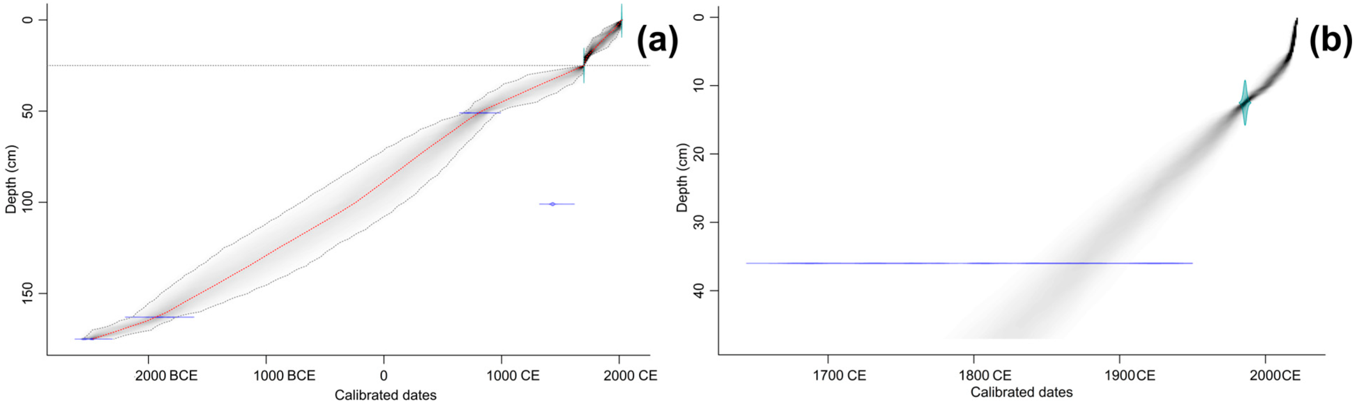
2.4. Chronology of the Peat Deposits

Chronology of the undisturbed peat deposits was determined by Accelerator Mass Spectrometer radiocarbon dating (AMS 14C) of four samples (Table 1). The analysis was performed at the A. E. Lalonde AMS Laboratory (University of Ottawa, Ottawa, ON, Canada). The radiocarbon ages were calibrated (Table 1) with the IntCal20 [43] calibration curve in the package ‘clam’ [44]. The age-depth model (Table S1) was developed using the Bayesian-based package ‘rbacon’ [45]. A boundary was introduced at a depth 25 cm to account for an abrupt change in peat stratigraphy as a result of peat extraction. The model priors for accumulation rates were set to 20 and 5 years cm−1 for the top and the bottom sections, respectively. The age at the surface was set to 2021 CE.
The age of the deposits of the floating mat was determined by measuring the activities of excess 210Pb (210Pbex) and 137Cs in a combination of AMS 14C of a sample from a depth of 36 cm (Table 1). The AMS 14C dating was performed at the State Key Laboratory of Isotope Geochemistry, Guangzhou Institute of Geochemistry (Chinese Academy of Sciences, Guangzhou, China). The radiocarbon date was calibrated with the IntCal20 [43] calibration curve in the package ‘clam’ [44]. The activities of 210Pbex and 137Cs were measured for contiguous 5 cm thick samples (1.2–12 g) at the Radiochemistry Department of Lomonosov Moscow State University (Russia) using a high-purity germanium (HPGe) detector (GEM-C5060P4-B; ORTEC, Atlanta, GA, USA) with a beryllium window (relative efficiency 20%). The 210Pbex activity of the peat samples was determined by subtracting the 226Ra activity from total 210Pb activity. The activity of 226Ra was estimated by two lines, one belonging to radium itself (186 keV), and the other to its daughter 214Bi (609 keV). The activity of 137Cs was estimated by line 661 keV. The obtained spectra were processed using Spectraline software that considers the density self-adsorption of an examined sample which is crucial for the registration of gamma-quants of low energy produced by 210Pb (46.3 keV). The exposition time was not less than 60,000 s. The uncertainties included sampling uncertainty (3%), sample preparation uncertainty (2%) and measurement uncertainty (2%), and in total did not exceed 8%. The age-depth model (Table S1) was built using the ‘rplum’ package [46]. All dates are quoted in the text as 2σ cal yr Before Common Era/Common Era (BCE/CE).

2.5. Loss on Ignition (LOI) and Peat Humification

LOI of peat was determined according to Heiri et al. [47]. Peat samples (1 cm3) were taken at 1–2 cm resolution and placed in a crucible. The samples were dried at 95 °C for 10–14 h, cooled to room temperature for 25–30 min and weighed to obtain a dry weight (DW). The crucibles with dry samples were placed in a muffle furnace and ignited at 550 °C for 4 h. Then, the crucibles were cooled to room temperature for 30–40 min and weighed to determine the ignition weight (IW). The remained material was discarded and the empty crucibles were weighed to obtain the crucible weight (CW). LOI was calculated as (DW − IW − CW)/(DW − CW) × 100%.
Peat humification was measured following the protocols suggested by Chambers et al. [19]. The samples were dried at a temperature of 50 °C until the weight was stable and then ground in an agate mortar. A 0.2 g sample of the ground material was then placed in a beaker and mixed with 100 mL of 8% NaOH. The beakers were heated at a temperature of 95 °C for 1 h with occasional stirring. The content of each beaker was poured into volumetric flasks and topped up to 200 mL with distilled water. Each sample was filtered (Whatman No. 1) into 50 mL volumetric flasks. The filtrate was diluted to 100 mL with distilled water. The light absorbance of the filtrate was measured with a spectrophotometer at a wavelength of 540 nm.

2.6. Plant Macrofossil Analysis

Every second sample of the 2 cm thick slices (2 cm3) was used for plant macrofossil analysis. The samples were washed with warm water using a sieve with 125 μm mesh size. The sieving residue was collected and examined using a ZEISS Primo Star microscope. Plant residues (leaves, roots and epidermis) were identified following Katz et al. [48] and were expressed in absolute numbers. Plant residues with a content of less than 5% of the total counts per sample were not determined to the species level and marked as “Other herbs” on the diagrams. The percentage of taxonomic groups of Sphagnum was estimated using the branch leaves, which were examined under a microscope at magnification ×100. Species identification of Sphagnum was carried out separately using stem leaves following Ignatov [49] and Laine et al. [50].

2.7. Pollen Analysis

For the pollen analysis, samples (1 cm3) were collected at 1–2 cm intervals. Each sample was treated with 10% KOH, mixed in a vortex and heated in a water bath for 10 min. The samples from the depths of 160 cm and lower contained a considerable proportion of mineral fraction and were prepared according to the protocol “Preparation of organic sediments for pollen analysis” [51]. After heating in a water bath, each sample was washed with distilled water (5–7 cycles) to restore neutral pH. Then, 3–5 mL of a heavy liquid (a sodium polytungstate solution; density of 2 g cm−3) was added. The samples were centrifuged (10 min, 3500 rpm) and rinsed with distilled water. The spores and pollen were counted and identified on glycerin temporary slides at a magnification of ×400 under a light microscope. The total pollen count included 450 pollen grains which were identified following Moore et al. [52], Faegri et al. [53] and an electronic MSU database (“Information system of identification of plant objects on the basis of carpological, palynological and anatomical data”; http://botany-collection.bio.msu.ru/pollen-speciment accessed on 6 March 2022). Pollen counts were converted to percentages by dividing the number of pollen grains of taxa by the total counts of pollen grains. The proportion of spores were calculated by dividing the number of spores by the total sum of identified pollen grains and spores.

2.8. Testate Amoeba Analysis

Samples for testate amoeba analysis were prepared according to the standard protocol based on filtration and concentration of water suspensions [54]. Three grams of peat were mixed with water, left to soak and shaken on a flask shaker for 10 min. After that, the samples were left to settle for a day. At the next stage, they were concentrated by sedimentation for several hours to 10 mL, and the obtained samples were fixed using 1 mL of formalin. Species identification and tailing of testate amoebae was carried out by direct light microscopy of a suspension using a binocular microscope (Biomed, Moscow, Russia) at ×200–×400 magnification using high taxonomic resolution approach [55].

2.9. Macrocharcoal Analysis

Macrocharcoal analysis of the peat samples was conducted following the methods suggested by Mooney and Winner [56]. The undisturbed peat deposits were continuously subsampled (volume of 1 cm3) with a resolution of 1 cm. The samples were left in 100 mL of 10% aqueous NaOCl solution for at least three days to lighten organic matter that was not exposed to elevated temperatures. Then the samples were washed through a sieve with a mesh size of 125 μm and the residue was placed into a Petri dish. Tallying of macrocharcoal was carried out at ×40 magnification using a dissecting microscope. The obtained data were analyzed using the ‘tapas’ package [57] to identify peaks which were interpreted as fire episodes and fire return intervals. The analysis involved interpolating CHAR values to a constant sampling resolution (the median sample resolution age of 25 years), decomposing that record into background and peak components using a moving median (500 years smoothing-window width), and evaluating the peak samples using both the 95th percentile of the modelled noise distribution obtained with a local 2-component Gaussian mixture model and a peak-screening test. The interval between charcoal peaks was interpreted as the fire return interval.

2.10. Data Analyses

The data were visualized and analyzed using the R language environment [58] with the packages ‘analogue’ [59] and ‘rioja’ [60]. Statistically significant stratigraphic zones were defined by the constrained incremental sum of squares cluster analysis [61] and a broken-stick model [62]. The main trends in pollen and plant macrofossil composition were visualized with Principal Component Analysis (PCA).

3. Results

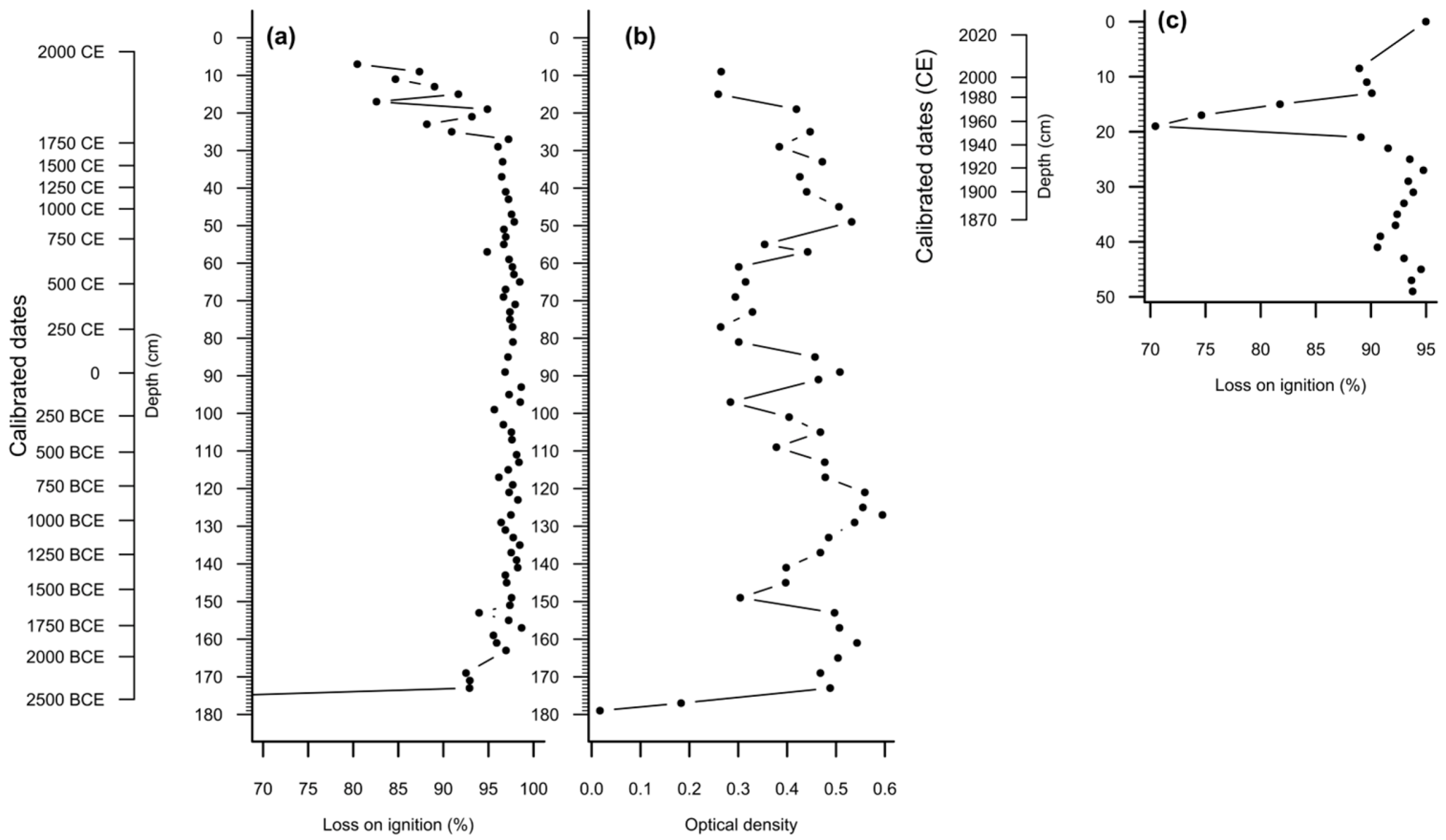
3.1. Peat Stratigraphy, Chronology and Properties

The deposits at the bottom (189–176 cm) of the undisturbed peat were formed of grey-brown coarse sand with some organic matter, i.e., peaty soil (Figure 2a), which was dated as 2585–2302 BCE (Table 1, Figure 3a). The overlying layers were moderately or highly decomposed peat (Figure 2a) with an average sedimentation time of 26.6 years cm−1 (based on the basal date). The date at the depth of 101 cm (1412–1451 CE) is considered as an outlier (younger than expected) by the Bayesian modelling approach (Figure 3a) and could be a result of contamination with the corer tip. (Other possible explanations for this outlier such as peat extraction activities, a change in the peatland surface level or invasion of the new vegetation might be largely excluded due to preservation of the stratigraphy in the other layers and relatively deep position of this sample). The top 25–0 cm of the deposits was represented by moist, highly decomposed, dark-brown loose peat mixed with soil and numerous remains of roots, birch bark and large woody fragments (Figure 2a) that presumably formed after peat extraction during the period of extensive anthropogenic impacts (Figure 3a). There is a possibility that under this 25 cm top layer, a small part of the peat was removed during intensive peat extraction in the second half of the 19th century, which is reflected in a sharp increase in the peat accumulation rate in the age-depth model (Figure 3a). The floating mat deposits were formed from slightly decomposed remains of Sphagnum mosses in the top 30 cm underlaid by sedge peat (Figure 2b). According to the radiometric dating based on 210Pbex (Figure 3b), the deposits at the depth of 30 cm were formed around 1915 CE, whereas the lower layers belong to the older peat deposits left from the peat extraction in the second half of 19th century.
LOI was the lowest at the bottom of undisturbed peat deposits (2.3–6.6% at depths of 189–176 cm; 2585–2490 BCE) (Figure 4a, the lowest values are not shown to improve readability; see Table S2 for the full data set) and then sharply increased to 65.5% at depths of 176–174 cm (2490 BCE). Further, LOI values increased to 92.5–92.9% at the depths of 174–168 cm (2490–2156 BCE) (Figure 3a) and remained at the highest levels (95.6–98.6%) within the depth range 168–25 cm (1850 CE) with two insignificant drops at the depths of 154–152 cm (94.0%) and 58–56 cm (94.9%). A considerable decrease in LOI (80.5–94.9%) was observed in the top layers (25–0 cm) (Figure 4a). The LOI values at the bottom deposits of the floating vegetation mat (Figure 4c) were relatively high and stable (90.5–94.5%) to the depth of 30 cm (1915 CE). After that, LOI values became variable and sharply dropped to 70% at the depth of 19 cm (1956 CE) but then rose again.
Peat humification of the undisturbed core was the lowest at the bottom (180–174 cm) due to the high content of the mineral fraction (Figure 4b; Table S2). After that, peat humification was high at the depths of 174–150 cm (2490–1590 CBE), 140–98 cm (1315–185 CBE), 96–86 cm (140 BCE–71 CE) and 54–25 cm (740–1850 CE). The periods of low peat humification values were observed at the depths of 150–140 cm (1590–1315 BCE), 98–96 cm (185–140 BCE), 86–54 cm (71–740 CE) and 25–0 cm (1850 CE–present day).

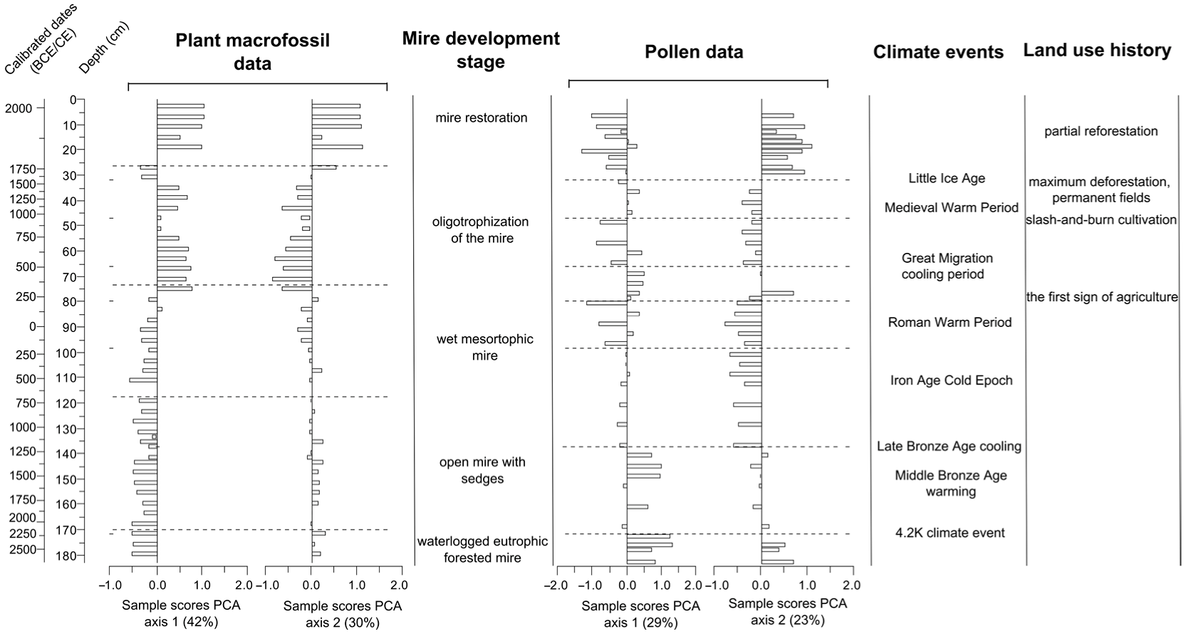
3.2. Plant Macrofossils

Based on the results of the constrained cluster analysis of plant macrofossil composition (PMF), four zones can be distinguished in the undisturbed peat core (Figure 5a; Table S3).
Zone PMF1.1 (175–117 cm; 2490–685 BCE) was dominated by Carex spp. (including Carex lasiocarpa, Carex rostrata, Carex cespetosa and Carex vesicaria) and Scirpus with less abundant remains of Salix sp., Carex acuta and other herbs. Menyanthes trifoliata was observed at the beginning of the zone. Overall, this zone reflects the initial stage of peatland formation which originated from a waterlogged eutrophic forested mire which transformed to an open mire with sedges, willow bushes and the presence of Sphagnum by 1700 BCE.
Zone PMF1.2 (117–72 cm; 685 BCE–450 CE) was characterized by the dominance of the same Carex species (except for Carex cespetosa), Scirpus and other herbs with a greater diversity of Sphagnum mosses. This indicates a formation of a wet mesotrophic peatland.
In Zone PMF1.3 (72–25 cm; 450–1850 CE), the dominance of sedges macrofossils remained with the complete disappearance of Carex spp., Carex vesicaria, Scirpus and other herbs, which were replaced by Phragmites australis and Eriophorum spp. At the beginning of the zone, Carex lasiocarpa was replaced by Carex rostrata and a newly appeared species, Carex limosa. By the end of the zone, Carex limosa had disappeared again, whereas Carex lasiocarpa and Carex acuta had become more abundant. Overall, these changes might indicate oligotrophization of the mire.
Zone PMF1.4 (25–0 cm; 1850 CE–present days) was characterized by high abundances of Pinus sylvestris and Eriophorum spp., decreasing diversity and abundance of Carex spp. These layers were formed after the peat extraction and correspond to the period of mire restoration.
The plant macrofossil composition in the peat core from the floating vegetation mat could be subdivided in four zones (Figure 5b; Table S3).
Zone PMF2.1 (50–36 cm; undetermined age–1872 CE) was dominated by the remains of sedges (Carex lasiocarpa, Carex vesicaria, Carex omskiana and Carex rostrata) with Eriophorum spp. and Phragmites australis. This zone corresponds well to sedge peat observed in the undisturbed deposits (Zone PMF1.2).
Zone PMF2.2 (36–24 cm; 1872–1932 CE) was dominated by hydrophilic Sphagnum obtusum, Sphagnum cuspidatum with the presence Carex spp. and Eriophorum spp. reflecting the end of the initial stage of the Sphagnum quagmire formation.
Zone PMF2.3 (24–10 cm; 1932–2001 CE) was characterized by the disappearance of Sphagnum obtusum and the appearance of Sphagnum fallax, periderm of Pinus, various species of Carex and increasing abundance of green mosses. This indicates stabilization of the floating Sphagnum mat and a gradual decrease in surface wetness.
Zone PMF2.4 (10–0 cm; 2001—2021 CE) was characterized by a further decrease in wetness (the presence of Eriophorum vaginatum) and oligotrophization of the mire (the appearance of Sphagnum majus, Sphagnum divinum and a further development of Sphagnum fallax and Sphagnum balticum).

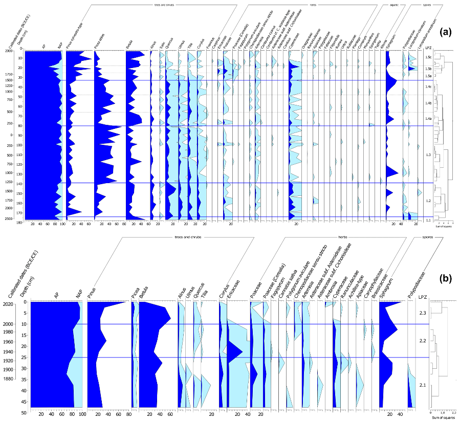
3.3. Pollen Analysis

Five zones were distinguished based on the result of pollen analysis of the undisturbed peat core (Figure 6a; Table S4).
In Zone LPZ1.1 (184–175 cm; 2585–2490 BCE), arboreal pollen (AP) contributed up to 98% of the pollen spectrum, which was dominated by Betula (40–45%), Alnus (15%) and Tilia (15–18%). There were also numerous spores of Lycopodium clavatum. The upper border of the zone is marked by a sharp drop in Betula and an increase in the Cyperaceae and Sphagnum curves. The zone reflects the initial period of mire formation as a result of terrestrial paludification.
In Zone LPZ1.2 (175–140 cm; 2490–1316 BCE), arboreal pollen contributed up to 80–95% and was represented primarily by Alnus (up to 20%) and taxa typical of broadleaf forests, such as Quercus (up to 30%), Tilia (10%), Ulmus (up to 10%) and Corylus (up to 10%). The Betula pollen decreased to 10–20%, in contrast to the previous zone. There were also Picea and Pinus (about 20%) in the pollen spectra. Herbaceous plants reached up to 15% and were represented by Cyperaceae (up to 12%), Poaceae and Artemisia (1–2% each). Sphagnum spores reached 20% of the total counts. In the layer 160–162 cm (1850 BCE), a few pollen grains of cultivated cereals (Cerealia type) were detected, but other indicators of agriculture were not observed. These pollen spectra might indicate an open mire with sedges and Sphagnum mosses in local vegetation, surrounded by a broadleaf forest with an admixture of alder and spruce.
In Zone LPZ1.3 (140–80 cm; 1316 BCE–200 CE), the contribution of arboreal pollen was maximal compared with the other zones (95–99%). Picea dominated during this period (about 50%), whereas broadleaf species were still present in lower amounts (about 20%). Pollen of Carpinus was detected at minor levels. The contribution of herbaceous plants was less than 5%. The overall species diversity was low and was mainly represented by taxa common for mires: Cyperaceae, Filipendula, Comarum, Alisma and Menyanthes (less than 3% in total). The participation of Sphagnum mosses did not exceed a few percent.
In Zone LPZ1.4 (80–32 cm; 200–1581 CE), the proportion of arboreal pollen ranged from 82 to 98% of the total pollen spectrum and was dominated by Betula (Subzone 1.4a), Picea (Subzone 1.4b) or both (Subzone 1.4c). Broadleaf forest taxa were also constantly present, reaching 10 to 30% of the total arboreal pollen. In addition, pollen of Salix was also detected. The herbal pollen spectra were formed by herbs typical for mires (Cyperaceae, Sparganium, Comarum and Filipendula) and by the indicators of agriculture and cattle breeding (Cerealia-type, Centaurea cyanus, Urtica, Ranunculus, Apiaceae and Polygala). Sphagnum mosses increased their abundances.
In Zone LPZ1.5 (32–0 cm; 1581 CE–present days), arboreal pollen sharply decreased, reaching a minimum of 61% at the depth of 20 cm. The presence Pinus (up to 60%) and Betula (up to 40%) sharply increased. The relative abundance of Picea pollen was reduced, broadleaf trees and Corylus almost disappeared. The proportion of herbs (up to 39%) and their taxonomic diversity increased. Cyperaceae, wild and cultivated grasses (Triticum and Secale) dominated among herbs (Subzones 1.5a and 1.5b). This reflects a period of intensive agriculture in the area surrounding the mire. Ruderal (Artemisia, Chenopodium, Fagopyrum, Polygonum aviculare, Carduus, Asteroideae and Cichorioideae) and meadow taxa (Apiaceae, Fabaceae, Galium, Rumex and Filipendula) were also detected. Sphagnum mosses contributed up to 35% of the total pollen counts at the beginning of the zone.
The pollen diagram of the floating mat can be subdivided into three zones based on the constrained cluster analysis (Figure 6b, Table S4). Throughout the deposits, trees contribute 70–90% of the overall pollen spectrum.
Zone LPZ 2.1 (50–25 cm; undetermined age–1927 CE) was dominated by Betula and Pinus with a relatively high contribution of broadleaf species. The proportion of herbaceous plants reached 30%, with the predominance of wild and cultivated cereals. Cyperaceae, Artemisia and agricultural indicators (Polygonum aviculare, Asteraceae, Ranunculaceae and Apiaceae) were also detected. The proportion of Sphagnum spores increased by the end of the zone.
Zone LPZ2.2 (25–10 cm; 1927–2000 CE) was characterized by a decrease in the proportion of broadleaf trees, by a sharp and short-term peak of Ericaceae and a drop in Sphagnum spores with a subsequent rise to 40%. Poaceae (including Cerealia), Cyperaceae and Artemisia were the same as in the previous zone. Among herbs, rare occurrences of Brassicaceae, Caryophyllaceae, Polygonum aviculare were detected. The short-term peak of Ericaceae and the subsequent increase in Sphagnum mosses might indicate drainage of one part of the mire and flooding of another. Agriculture and forest usage of the area remained at the same levels as in the previous period.
In Zone LPZ2.3 (10–0 cm; 2000–2021 CE), pine dominated (75%), whereas the abundance and diversity of herbs, indicators of agricultural activity, were reduced. This reflects current state of the vegetation surrounding the mire that generally consists of pine forest with spruce in the undergrowth. The upper pine peak (65%) probably reflects the formation of a pine forest as a result of plantations in the 1960s.

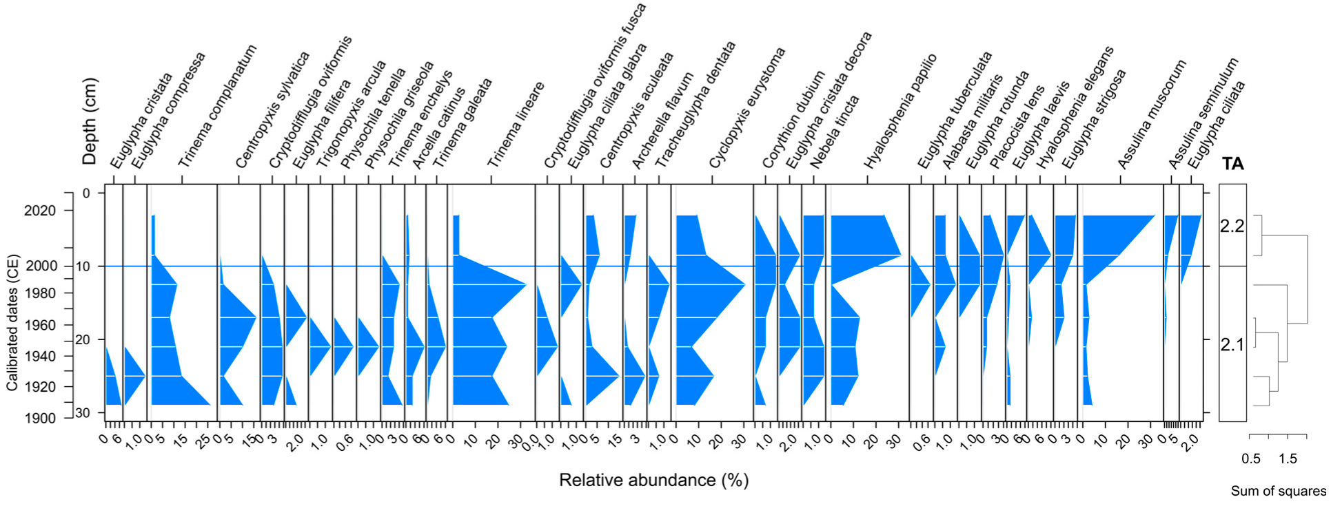
3.4. Testate Amoeba Analysis

Testate amoebae were observed in sufficient abundances only in the core extracted from the floating mat (Figure 7; Table S5), whereas in the undisturbed peat deposits, they were encountered sporadically and in low abundances. The low abundances of the testate amoebae in the undisturbed deposits might be explained by unfavorable conditions for their preservation in eutrophic and mesotrophic peats. In the short core, two zones could be distinguished based on the species composition of testate amoeba assemblages: TA1 (30–10 cm, 1915–2000 CE); and TA2 (10–0 cm, 2000–2021 CE). The lower zone was dominated by Trinema lineare (23%, here and also to the total number of counted shells per zone), Cyclopyxis eurystoma (16%), Trinema complanatum (14%), Centropyxis sylvatica (8%) and Hyalosphenia papilio (8%). In the top zone, a hydrophilic Sphagnum-dwelling taxon Hyalosphenia papilio (27%) became the most abundant and dominated together with xerophilic Assulina muscorum (24%). The other species typical for Zone TA2 were Cyclopyxis eurystoma (11%), Hyalosphenia elegans (6%), Centropyxis aculeata (5%), Assulina seminulum (4%), Euglypha laevis (4%) and Euglypha strigosa (4%). Overall, the changes in species composition of testate amoeba assemblages indicate an increasing proportion of specific Sphagnum-dwelling taxa in the top layer and the co-dominance of both hydrophilic and xerophilic taxa that might be related to unstable hydrological conditions.

3.5. Macrocharcoal Analysis

Macroscopic charcoal concentration values ranged between 0 and 287 (median:  3 pieces cm−3) (Table S6). The interpolated values charcoal accumulation rate (charAR) varied from 0 to 10.5 pieces cm−2 yr−1 (Figure 8a). At the early stages of peat formation (until 2500 BCE), charAR was characterized by two periods of relatively high charcoal accumulation with the maximal values reaching 1.4 pieces cm−2 yr−1. However, only one fire event was determined during that period. After that, for the most of the deposits, the charcoal accumulation rate was relatively low (<1 piece cm−2 yr−1), with the fire return interval ranging from 100 to 400 yrs fire−1 (Figure 8b). The charcoal accumulation rate sharply increased at the top of the deposits (starting from 1700 CE), varying from 2 to 10 pieces cm−2 yr−1, which was associated with frequent fire events and a constant supply of charcoal from the immediate surrounding area strongly affected by human activity.

4. Discussion

The results obtained during this study allowed us to reconstruct the peatland initiation, development and restoration in an area located near a large metropolis, Moscow city, using a multi-proxy approach with age constraints based on 14C, 137Cs and 210Pbex dating.

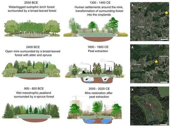
4.1. Peatland Initiation

According to the radiocarbon dating, paludification and peat deposition at the site began around 2550 BCE, and was probably associated with a sharp cooling, changes in moisture and groundwater levels (4.2 Ka event) (Figure 9). Overall, the 4.2 Ka event is not particularly noticeable in the pollen spectra, but these findings correspond well with the results of the previous studies which showed an increased river flow in the European part of Russia [63], including a drastic increase in water level of the river Moscow and its main tributaries during 2550–2150 BCE [64]. As a result, the hydrological regime of the area changed significantly, leading to the formation of mires in many depressions, e.g., Aksininskoe, Vozdvizhenske and Zabolotie mires which initiated around 2500 BCE [65,66]. However, in the study region (the Polesie landscape belt, European Russia), this period was not considered as the most active phase of peatland initiation [29] as it generally coincided with a warm climate and increased fire frequency. Our results on the macrocharcoal analysis indicate a relatively high fire intensity which together with the above-mentioned changes in hydrological regime of the area could promote the peatland development at the study site. It has been previously shown that fires might increase surface water run-off (mostly due to reduced evapo-transpiration after local deforestation), which results in greater levels and fluctuations of the ground water mire [67,68]. Peatland development started via terrestrial paludification as a waterlogged eutrophic birch forest surrounded by a broadleaf forest, as indicated by the dominance of Betula in pollen spectra and Carex spp., Scirpus, Menyanthes trifoliata and other herbs in plant macrofossils remains. The study region was characterized by a wide distribution of broadleaf forests during this period [20] and a relatively high intensity of fires which were not generally related to anthropogenic activity [30].

4.2. Development of the Peatland and the Surrounding Landscape

Around 1700 BCE, the swampy forest transformed into an open mire (with sedges, willow bushes and the presence of Sphagnum mosses) surrounded by a broadleaf forest with an admixture of alder and spruce (Figure 9). After that (around 1300 BCE), a sharp rise in Picea in the pollen spectra was detected and it was probably associated with the Iron Age Cold Epoch, which promoted the distribution of Picea on watersheds in the Moscow region [69]. A similar rise in the spruce curve was also detected in the peat deposits of a mire located in Losiny Ostrov around 850–950 BCE [70] and in other sites in the Moscow region [71,72]. The expansion of the spruce forests was also detected in the neighboring territories [20] starting from 550 BCE. However, broadleaf forests did not disappear completely and remained in some areas [20,21].
Starting from 250 CE, a sharp decline in Picea pollen counts was detected along with the rise in the Betula curve and the emergence of agricultural indicators. In the Losiny Ostrov deposits [70], a similar episode (the fall in Picea and the rise in Betula with subsequent fluctuations, and the appearance of charcoal and indicators of agricultural activity) was dated at around 250–350 CE. All of this obviously reflects the beginning of the human settlement around the mire and deforestation for agriculture (Figure 9). Although the presence of cultivated cereals pollen was not detected in this zone, the sharp rise in Betula with the simultaneous appearance of agricultural indicators (Centaurea cyanus) reflects reduction of primary spruce–broadleaf forests and the subsequent overgrowth of croplands with secondary birch forests. Our results of macrocharcoal analysis demonstrate a slight increase in fire activity. This combination of features can be interpreted as a reflection of the slash-and-burn agriculture. According to the plant macrofossils data, high diversity and abundance of Carex spp. together with the appearance of Eriophorum spp. indicate oligotrophization of the mire.
Since the beginning of the Common Era, pollen indicators of anthropogenic disturbances appear in the Moscow region, during which broadleaf forests were reduced and abandoned fields were transformed to the secondary pine or birch forests [21,73,74]. At least two early episodes of deforestation for agriculture (around 200 and 830 CE) separated by a period of restoration of spruce forests were distinguished in this study. The first episode can be attributed to the distribution of the late Dyakovo culture in the region [38]. The settlements of this period were observed in the valley of the Moscow River and might possibly occur in the basin of the Pekhorka River [38]. The second episode is obviously associated with the early Slavic colonization because several archaeological sites of the 10–12th centuries are known in the Pekhorka River valley (one of them is located less than 1 km from the studied area) [40]. In both periods, the slash-and-burn agriculture were also detected in other studies [9,30,75].
Starting from 1350 CE, decreases in the Picea and broadleaf tree curves together with rises in the Pinus curve and the proportion of wild and cultivated grasses (including ruderal and meadow taxa) were detected in the pollen spectra. These changes reflect the transformation of indigenous spruce–broadleaf forests into croplands (Figure 9). In the Moscow region, it was associated with the Slavic development at watersheds in the 14–16th centuries, the so-called internal colonization of the Moscow principality [39,40,76]. In the peat deposits from Losiny Ostrov, this period is dated as the 14th century CE [70]. Numerous settlements of this time are known in the territory of Losiny Ostrov and the valley of the Pekhorka River [40]. This was associated with a deforestation of the primary forests and their replacement with fields and meadows. By the end of the 16th century CE, the agricultural land clearance became more permanent, which resulted in a complete replacement of Quercus and Tilia by Betula and Pinus. The increased proportions of Betula and Pinus might be related to the abandonment of some fields as a result of the political crisis during 1598–1613 CE (Smuta) with the subsequent development of birch–pine forests. The distribution of agricultural landscapes and deforestation were widespread in the mid-eastern European territory over the past 600 years [22,23,24]. Due to the short time intervals between events of deforestation, primary forests did not regenerate [20]. The plant macrofossil analysis indicated that the Gorenki mire gradually became drier and transformed into a forested peatland by the mid-19th century CE when it was used for peat excavation.
The macrocharcoal analysis indicates that the charcoal accumulation rate during the mire development was relatively low except for the period starting from 1700 CE when human activity considerably increased. Previous studies showed that the impact of fires on vegetation in the region was especially high after 550 CE due to human influence [30]. However, prior to the human settlement in the area, the frequency of natural fires was relatively high and was generally driven by climatic conditions. The low macrocharcoal accumulation and fire frequency at the study site despite its close location to the oldest center of Slavic colonization can be explained by high local wetness.

4.3. Peatland Restoration

The analysis of the peat deposits of the floating vegetation mat indicates a successful restoration of the mire vegetation after peat extraction. The deposits at the bottom of the floating mat (Zone PMF 2.1) were represented by the remains of pioneer mat-forming species Carex lasiocarpa, Menyanthes trifoliata, Scirpus sp. and Phragmites australis [77,78]. The structure of the plant remains corresponds well with that of Zone PMF 1.2 in the undisturbed peat core. The upper layers were most likely removed by peat extraction, and the underlying peat floated to the surface, serving as the basis for the formation of the quagmire. The shoots, roots and rhizomes of these species contain specialized aerenchyma tissue [79] which makes them less dense than water. It has been previously shown that floating peat deposits might provide the substrate for Sphagnum colonization and formation of a floating vegetation mat during the natural terrestrialization of lakes [80]. Smolders et al. [81] showed that floating vegetation raft formation may occur if adequate substrate becomes buoyant after deep inundation of the remnant depression. Thus, peat remains composed of pioneer mat-forming species with aerenchyma tissues may favor restoration of floating mats in rewetted mires.
The floating mat was firstly colonized by Sphagnum cuspidatum and Sphagnum obtusum (Zone PMF 2.2), the remains of which were abundant in the deposits above the peat layer. These species can grow in various environments, from mesotrophic to eutrophic, in wet mires and pools, along streams and on lake margins [50]. Paleoecological data indicate [82] that Sphagnum obtusum prefers moderately wet habitats, and it was observed in a transitional phase between a fen that developed on lake sediments and a bog. It often dominates and is accompanied by vascular plants such as Scheuchzeria palustris, Carex rostrata, Comarum palustre and Oxycoccus palustris. In addition to the Sphagnum obtusum remains, the deposits of the floating mat contained remains of Sphagnum fallax and Sphagnum cuspidatum which are commonly observed as dominating species on floating rafts during mire restoration [81]. These species became the main peat forming plants after 1940 CE when a trend in decreasing surface wetness was observed based on the plant macrofossils. The testate amoebae results reflect unstable hydrological conditions as both hydrophilic Hyalosphenia papilio and xerophilic Assulina muscorum co-dominated in the top layers. The mixotrophic testate amoeba Hyalosphenia papilio, which contains symbiotic algae and normally dominates in the upper insolated layers of Sphagnum plants [83], is one of the most characteristic species indicating maturation of Sphagnum-dominated mires [84,85].
The pollen spectrum for the last 60 years showed a decrease in agricultural activity and forest restoration. The peak of Pinus abundance in pollen spectra in the 1960s corresponds with the pine tree plantation started in 1962 when the forest area adjacent to the Gorenki mire received the status of a recreation territory [41]. Other anthropogenic factors associated with reclamation work in the area surrounding the mire could also contribute to the further maintenance of pine forests, which is not typical for the zonal vegetation (i.e., mixed spruce–broadleaf forests) of the region [86]. Overall, these data indicate that the reduced anthropogenic impact and site protection may lead to bog restoration.

5. Conclusions

Restoration of mire ecosystems after peat extraction becomes increasingly important in the context of global climate change due to their considerable role in the maintenance of local diversity and contribution to atmospheric carbon sequestration and storage. This especially applies to the mires located in the areas affected by anthropogenic activities in the close vicinity of large cities. Using a multi-proxy paleoecological approach, this study investigates the long-term (during the Late Holocene) development and self-restoration (for more than 100 years) of Gorenki mire, which is located in the urban area of Moscow and was subjected to peat extraction during the second half of the 19th century. The analysis of undisturbed peat deposits shows that development of the mire and the surrounding vegetation underwent several stages related to climatic fluctuations and human impacts. Peat accumulation at the site started around 2550 BCE as a result of terrestrial paludification in response to numerous fire events and climate cooling that led to the formation of a waterlogged eutrophic birch forest. By 2400 BCE, the swampy forest had transformed into an open mire with Sphagnum mosses, sedges and willow bushes surrounded by a broadleaf forest with an admixture of alder and spruce. During 900–800 BCE, the mire was wet and mesotrophic and was surrounded by a spruce forest. Indicators of first human settlement around the mire and deforestation for agriculture were detected around 300–400 CE. This coincided with oligotrophization of the mire and a reduction in the primary spruce–broadleaf forests and was followed by the subsequent overgrowth of croplands by secondary birch forests. The population growth in the Moscow region during 14th century caused complete transformation of spruce–broadleaf forests into croplands; the mire became drier and turned into a forested peatland. Analysis of the floating vegetation mat deposits formed after peat extraction shows that self-restoration of the mire started from a Sphagnum cuspidatum/obtusum quagmire on floating peat remains. During 1960–2000, the Sphagnum mat was stabilized and exhibited a gradual decrease in surface wetness. After that, the agricultural activity in the area substantially decreased and pine forests were restored, while the floating vegetation mat became drier and more oligotrophic. These results suggest that mire ecosystems are very sensitive to climatic and anthropogenic impacts and undergo relatively rapid transformations in their state at the time scale of centuries. The time scale of mire self-restoration after peat extraction is comparable in duration to the historical transformations but might considerably depend on the successful re-introduction of mire vegetation on the disturbed sites.

Supplementary Materials

The following supporting information can be downloaded at: https://www.mdpi.com/article/10.3390/d15030448/s1, Table S1: Age-depth model data for the peat deposits in the Gorenki mire; Table S2: Loss on ignition and peat humification (as light absorbance of an alkali extract) of the peat deposits in the Gorenki mire; Table S3: Plant macrofossil composition (%) of the peat deposits in the Gorenki mire; Table S4: Pollen and spore composition (%) of the peat deposits in the Gorenki mire; Table S5: Testate amoebae composition (%) of the floating mat deposits in the Gorenki mire; Table S6. Macrocharcoal data for the undisturbed peat deposits of the Gorinki mire.

Author Contributions

Conceptualization and methodology, Y.A.M., A.N.T., E.G.E. and N.G.M.; pollen analysis, E.G.E., V.E.P., E.V.K. and I.A.Z.; plant macrofossils analysis, N.G.M. and A.D.M.; testate amoeba analysis, A.N.T. and A.D.C.; macrocharcoal analysis, N.G.M. and M.S.P.; loss on ignition analysis, E.G.E. and A.A.T.; peat humification, A.N.T., M.V.Z. and A.D.M.; lead dating, S.N.K. and N.V.K.; radiocarbon analysis, P.D.; original draft preparation, Y.A.M.; review and editing, Y.A.M., A.N.T., E.G.E., N.G.M., V.E.P., E.V.K., A.V.K. and P.D.; visualization, A.N.T., V.E.P., E.V.K. and M.S.P.; project administration and funding acquisition, Y.A.M. and A.V.K. All authors have read and agreed to the published version of the manuscript.

Funding

This research was funded by Russian Science Foundation, grant number 19-14-00102. This research was performed according to the Development Program of the Interdisciplinary Scientific and Educational School of Lomonosov Moscow State University “The future of the planet and global environmental change”. The study of 210Pbex and 137Cs was supported by a state assignment to Lomonosov Moscow State University “Solving of problems of nuclear energy and environmental safety problems, as well as diagnostics of materials using ionizing radiation” (Project Reg. No. 122030200324-1).

Institutional Review Board Statement

Not applicable.

Data Availability Statement

The data presented in this study are available in the Supplementary Materials.

Acknowledgments

We gratefully acknowledge four anonymous reviewers, whose critical notes sufficiently improved our manuscript. This work was carried out as part of the academic course “Historical Ecology”, which was taught to first-year master’s students of the Faculty of Biology of Lomonosov Moscow State University in the 2021/2022 academic year. During the course, all the work was conducted by students (V.E.P., E.V.K., M.S.P., A.D.C., A.D.M., I.A.Z., A.A.T. and M.V.Z.) under the guidance of teachers (Y.A.M., A.N.T., E.G.E. and N.G.M.). Lead dating was carried out in the Radiochemistry Department, Faculty of Chemistry, Lomonosov Moscow State University (S.N.K. and N.V.K.).

Conflicts of Interest

The authors declare no conflict of interest. The funders had no role in the design of the study; in the collection, analyses, or interpretation of data; in the writing of the manuscript; or in the decision to publish the results.

References

  1. Montanarella, L.; Jones, R.J.A.; Hiederer, R. The Distribution of Peatland in Europe. Mires Peat 2006, 1, 1. [Google Scholar]
  2. Rydin, H.; Jeglum, J.K.; Bennett, K.D. The Biology of Peatlands, 2nd ed.; OUP: Oxford, UK, 2013; ISBN 978-0-19-960299-5. [Google Scholar]
  3. Gorham, E. Northern Peatlands: Role in the Carbon Cycle and Probable Responses to Climatic Warming. Ecol. Appl. 1991, 1, 182–195. [Google Scholar] [CrossRef] [PubMed]
  4. Blodau, C. Carbon Cycling in Peatlands: A Review of Processes and Controls. Environ. Rev. 2002, 10, 111–134. [Google Scholar] [CrossRef]
  5. Frolking, S.; Talbot, J.; Jones, M.C.; Treat, C.C.; Kauffman, J.B.; Tuittila, E.-S.; Roulet, N. Peatlands in the Earth’s 21st Century Climate System. Environ. Rev. 2011, 19, 371–396. [Google Scholar] [CrossRef]
  6. Holden, J. Peatland Hydrology and Carbon Release: Why Small-Scale Process Matters. Philos. Trans. R. Soc. Math. Phys. Eng. Sci. 2005, 363, 2891–2913. [Google Scholar] [CrossRef] [Green Version]
  7. Janse, J.H.; van Dam, A.A.; Hes, E.M.A.; de Klein, J.J.M.; Finlayson, C.M.; Janssen, A.B.G.; van Wijk, D.; Mooij, W.M.; Verhoeven, J.T.A. Towards a Global Model for Wetlands Ecosystem Services. Curr. Opin. Environ. Sustain. 2019, 36, 11–19. [Google Scholar] [CrossRef]
  8. Prentice, C. Records of Vegetation in Time and Space: The Principles of Pollen Analysis. In Vegetation History; Handbook of Vegetation Science; Huntley, B., Webb, T., Eds.; Springer: Dordrecht, Netherlands, 1988; pp. 17–42. ISBN 978-94-009-3081-0. [Google Scholar]
  9. Ponomarenko, E.V.; Ershova, E.G.; Krenke, N.A.; Bakumenko, V.O. Traces of Iron Age slash-and-burn agriculture under the Slavic kurgans at the MSU Zvenigorod Biological Station. Brief Commun. Inst. Archaeol. 2021, 263, 60–73. [Google Scholar] [CrossRef]
  10. Whitlock, C.; Bartlein, P.J. Holocene Fire Activity as a Record of Past Environmental Change. In Developments in Quaternary Sciences; The Quaternary Period in the United States; Elsevier: Amsterdam, Netherlands, 2003; Volume 1, pp. 479–490. [Google Scholar]
  11. Higuera, P.E.; Peters, M.E.; Brubaker, L.B.; Gavin, D.G. Understanding the Origin and Analysis of Sediment-Charcoal Records with a Simulation Model. Quat. Sci. Rev. 2007, 26, 1790–1809. [Google Scholar] [CrossRef]
  12. Whitlock, C.; Higuera, P.E.; McWethy, D.B.; Briles, C.E. Paleoecological Perspectives on Fire Ecology: Revisiting the Fire-Regime Concept. Open Ecol. J. 2010, 3, 6–23. [Google Scholar] [CrossRef] [Green Version]
  13. Vannière, B.; Colombaroli, D.; Chapron, E.; Leroux, A.; Tinner, W.; Magny, M. Climate versus Human-Driven Fire Regimes in Mediterranean Landscapes: The Holocene Record of Lago Dell’Accesa (Tuscany, Italy). Quat. Sci. Rev. 2008, 27, 1181–1196. [Google Scholar] [CrossRef] [Green Version]
  14. Birks, H.H. Plant Macrofossil Introduction. Encycl. Quat. Sci. 2007, 3, 2266–2288. [Google Scholar]
  15. Mauquoy, D.; Hughes, P.; Van Geel, B. A Protocol for Plant Macrofossil Analysis of Peat Deposits. Mires Peat 2010, 7, 6. [Google Scholar]
  16. Hughes, P.D.M.; Barber, K.E. Contrasting Pathways to Ombrotrophy in Three Raised Bogs from Ireland and Cumbria, England. Holocene 2004, 14, 65–77. [Google Scholar] [CrossRef]
  17. Charman, D.J. Biostratigraphic and Palaeoenvironmental Applications of Testate Amoebae. Quat. Sci. Rev. 2001, 20, 1753–1764. [Google Scholar] [CrossRef]
  18. Mitchell, E.A.D.; Charman, D.J.; Warner, B.G. Testate Amoebae Analysis in Ecological and Paleoecological Studies of Wetlands: Past, Present and Future. Biodivers. Conserv. 2008, 17, 2115–2137. [Google Scholar] [CrossRef] [Green Version]
  19. Chambers, F.M.; Beilman, D.W.; Yu, Z. Methods for Determining Peat Humification and for Quantifying Peat Bulk Density, Organic Matter and Carbon Content for Palaeostudies of Climate and Peatland Carbon Dynamics. Mires Peat 2010, 7, 7. [Google Scholar]
  20. Novenko, E.Y.; Tsyganov, A.N.; Volkova, E.M.; Kupriyanov, D.A.; Mironenko, I.V.; Babeshko, K.V.; Utkina, A.S.; Viktor, P.; Mazei, Y.A. Mid- and Late Holocene Vegetation Dynamics and Fire History in the Boreal Forest of European Russia: A Case Study from Meshchera Lowlands. Palaeogeogr. Palaeoclimatol. Palaeoecol. 2016, 459, 570–584. [Google Scholar] [CrossRef]
  21. Rudenko, O.V.; Volkova, E.M.; Babeshko, K.V.; Tsyganov, A.N.; Mazei, Y.A.; Novenko, E.Y. Late Holocene Vegetation Dynamics and Human Impact in the Catchment Basin of the Upper Oka River (Mid-Russian Uplands): A Case Study from the Orlovskoye Polesye National Park. Quat. Int. 2019, 504, 118–127. [Google Scholar] [CrossRef]
  22. Novenko, E.Y.; Zyuganova, I.S.; Volkova, E.M.; Dyuzhova, K.V. A 7000-Year Pollen and Plant Macrofossil Record from the Mid-Russian Upland, European Russia: Vegetation History and Human Impact. Quat. Int. 2019, 504, 70–79. [Google Scholar] [CrossRef]
  23. Novenko, E.Y.; Eremeeva, A.P.; Chepurnaya, A.A. Reconstruction of Holocene Vegetation, Tree Cover Dynamics and Human Disturbances in Central European Russia, Using Pollen and Satellite Data Sets. Veg. Hist. Archaeobotany 2014, 23, 109–119. [Google Scholar] [CrossRef]
  24. Novenko, E.Y.; Volkova, E.; Glasko, M.; Zuganova, I. Palaeoecological Evidence for the Middle and Late Holocene Vegetation, Climate and Land Use in the Upper Don River Basin (Russia). Veg. Hist. Archaeobotany 2012, 21, 337–352. [Google Scholar] [CrossRef]
  25. Payne, R.J.; Malysheva, E.; Tsyganov, A.N.; Pampura, T.; Novenko, E.Y.; Volkova, E.M.; Babeshko, K.V.; Mazei, Y.A. A Multi-Proxy Record of Holocene Environmental Change, Peatland Development and Carbon Accumulation from Staroselsky Moch Peatland, Russia. Holocene 2016, 26, 314–326. [Google Scholar] [CrossRef]
  26. Nosova, M.; Severova, E.; Volkova, O. A 6500-Year Pollen Record from the Polistovo-Lovatskaya Mire System (Northwest European Russia). Vegetation Dynamics and Signs of Human Impact. Grana 2017, 56, 410–423. [Google Scholar] [CrossRef]
  27. Tsyganov, A.N.; Kupriyanov, D.A.; Babeshko, K.V.; Borisova, T.V.; Chernyshov, V.A.; Volkova, E.M.; Chekova, D.A.; Mazei, Y.A.; Novenko, E.Y. Autogenic and Allogenic Factors Affecting Development of a Floating Sphagnum-Dominated Peat Mat in a Karst Pond Basin. Holocene 2019, 29, 120–129. [Google Scholar] [CrossRef]
  28. Mazei, Y.A.; Tsyganov, A.N.; Bobrovsky, M.V.; Mazei, N.G.; Kupriyanov, D.A.; Gałka, M.; Rostanets, D.V.; Khazanova, K.P.; Stoiko, T.G.; Pastukhova, Y.A.; et al. Peatland Development, Vegetation History, Climate Change and Human Activity in Valdai Uplands (Central European Russia) during the Holocene: A Multi-Proxy Palaeoecological Study. Diversity 2020, 12, 462. [Google Scholar] [CrossRef]
  29. Novenko, E.Y.; Mazei, N.G.; Kupriyanov, D.A.; Kusilman, M.V.; Olchev, A.V. Peatland Initiation in Central European Russia during the Holocene: Effect of Climate Conditions and Fires. Holocene 2021, 31, 545–555. [Google Scholar] [CrossRef]
  30. Kupriyanov, D.A.; Novenko, E.Y. Reconstruction of the Holocene Dynamics of Forest Fires in the Central Part of Meshcherskaya Lowlands According to Antracological Analysis. Contemp. Probl. Ecol. 2019, 12, 204–212. [Google Scholar] [CrossRef]
  31. Sirin, A.; Minayeva, T.; Yurkovskaya, T.; Kuznetsov, O.; Smagin, V.; Fedotov, Y. Russian Federation (European Part). In Mires and Peatlands of Europe: Status, Distribution and Conservation; Schweizerbart Science Publishers: Stuttgart, Germany, 2017; p. 780. [Google Scholar]
  32. Tcvetkov, P. The History, Present Status and Future Prospects of the Russian Fuel Peat Industry. Mires Peat 2017, 19, 14. [Google Scholar] [CrossRef]
  33. Wheeler, B.D.; Shaw, S.C.; Fojt, W.J.; Robertson, R.A. Restoration of Temperate Wetlands, 1st ed.; Wiley: Hoboken, NJ, USA, 1995; ISBN 978-0-471-95105-6. [Google Scholar]
  34. Andersen, R.; Farrell, C.; Graf, M.; Muller, F.; Calvar, E.; Frankard, P.; Caporn, S.; Anderson, P. An Overview of the Progress and Challenges of Peatland Restoration in Western Europe. Restor. Ecol. 2017, 25, 271–282. [Google Scholar] [CrossRef]
  35. Gorham, E.; Rochefort, L. Peatland Restoration: A Brief Assessment with Special Reference to Sphagnum Bogs. Wetl. Ecol. Manag. 2003, 11, 109–119. [Google Scholar] [CrossRef]
  36. Chimner, R.A.; Cooper, D.J.; Wurster, F.C.; Rochefort, L. An Overview of Peatland Restoration in North America: Where Are We after 25 Years? Restor. Ecol. 2017, 25, 283–292. [Google Scholar] [CrossRef]
  37. Aleksandrova, V.D.; Yurkovskaya, T.K. Geobotanical Zoning of the Non-Chernozem Region of the European Part of the RSFSR; Nauka: St. Petersburg, Russia, 1989; ISBN 5-02-026546-2. (In Russian) [Google Scholar]
  38. Krenke, A.N. Antiquities of the Moskva River Basin from the Neolithic to the Middle Ages: Stages of Cultural Development, the Formation of a Productive Economy and An Anthropogenic Landscape; Svitok: Smolensk, Russia, 2019; 392p. (In Russian) [Google Scholar]
  39. Chernov, S.Z. Rural settlements and landscapes on Pekhorka: The riddle of economic recovery in Meshchora under the first Moscow Princes. In Culture of Medieval Moscow. Historical Landscapes; Nauka: Moscow, Russia, 2005; Volume 1, pp. 126–188. (In Russian) [Google Scholar]
  40. Chernov, S.Z. Domain of Moscow dukes in urban camps. 1271–1505 years (Acts of Moscow Rus. Micro-regional studies. Volume 2). In Culture of Medieval Moscow. Historical Landscapes; Nauka: Moscow, Russia, 2005; Volume 2, pp. 51–55. [Google Scholar]
  41. Galanin, A.E. Balashikha in Persons and Biographies: Encyclopedic Dictionary (to the 175th Anniversary of Balashikha); Delta: Moscow, Russia, 2005; ISBN 5-902370-29-9. (In Russian) [Google Scholar]
  42. Vleeschouwer, F.; Chambers, F.; Swindles, G. Coring and Sub-Sampling of Peatlands for Palaeoenvironmental Research. Mires Peat 2010, 7, 1. [Google Scholar]
  43. Reimer, P.J.; Austin, W.E.N.; Bard, E.; Bayliss, A.; Blackwell, P.G.; Ramsey, C.B.; Butzin, M.; Cheng, H.; Edwards, R.L.; Friedrich, M.; et al. The IntCal20 Northern Hemisphere Radiocarbon Age Calibration Curve (0–55 Cal KBP). Radiocarbon 2020, 62, 725–757. [Google Scholar] [CrossRef]
  44. Blaauw, M.; Christen, J.A.; Vazquez, J.E.; Goring, S. clam: Classical Age-Depth Modelling of Cores from Deposits 2022. R Package Version 2.5.0. Available online: https://CRAN.R-project.org/package=clam (accessed on 27 December 2022).
  45. Blaauw, M.; Christen, J.A. Flexible Paleoclimate Age-Depth Models Using an Autoregressive Gamma Process. Bayesian Anal. 2011, 6, 457–474. [Google Scholar] [CrossRef]
  46. Blaauw, M.; Christen, J.; Aquino-Lopez, M. rplum: Bayesian Age-Depth Modelling of Cores Dated by Pb-210, R Package Version 0.2.2, 2021. Available online: https://cran.r-project.org/package=rplum (accessed on 27 December 2022).
  47. Heiri, O.; Lotter, A.F.; Lemcke, G. Loss on Ignition as a Method for Estimating Organic and Carbonate Content in Sediments: Reproducibility and Comparability of Results. J. Paleolimnol. 2001, 25, 101–110. [Google Scholar] [CrossRef]
  48. Katz, N.Y.; Katz, S.V.; Skobeeva, E.I. Atlas of Plant Residues in Peats; UDK: 553.97.06 (084.4); Nedra: Moscow, Russia, 1977. (In Russian) [Google Scholar]
  49. Ignatov, M.S.; Ignatova, E.A. Flora of Mosses in the Middle part of European Russia. T. 1: Sphagnaceae-Hedwiigiaceae; KMK: Moscow, Russia, 2003; Volume 1, ISBN 5-87317-104-1. (In Russian) [Google Scholar]
  50. Laine, J.; Harju, P.; Timonen, T.; Laine, A.; Tuittila, E.-S.; Minkkinen, K.; Vasander, H. The Intricate Beauty of Sphagnum Mosses-A Finnish Guide to Identification; University of Helsinki, Department of Forest Ecology: Helsinki, Finland, 2009; ISBN 978-952-10-5617-8. [Google Scholar]
  51. Gajewski, K. Preparation of Organic Sediments for Pollen Analysis. Available online: http://www.lpc.uottawa.ca/resources/pollen.html (accessed on 23 November 2009).
  52. Moore, P.D.; Webb, J.A.; Collison, M.E. Pollen Analysis, 2nd ed.; Blackwell: Oxford, UK, 1991; ISBN 9780865428959. [Google Scholar]
  53. Faegri, K.; Kaland, P.E.; Krzywinski, K. Textbook of Pollen Analysis, 4th ed.; John Wiley & Sons Ltd.: Chichester, UK, 1989; ISBN 0-471-92178-5. [Google Scholar]
  54. Mazei, Y.A.; Chernyshov, V.A. Testate Amoebae Communities in the Southern Tundra and Forest-Tundra of Western Siberia. Biol. Bull. 2011, 38, 789–796. [Google Scholar] [CrossRef]
  55. Mitchell, E.A.D.; Lamentowicz, M.; Payne, R.J.; Mazei, Y. Effect of Taxonomic Resolution on Ecological and Palaeoecological Inference-A Test Using Testate Amoeba Water Table Depth Transfer Functions. Quat. Sci. Rev. 2014, 91, 62–69. [Google Scholar] [CrossRef] [Green Version]
  56. Mooney, S.D.; Tinner, W. The Analysis of Charcoal in Peat and Organic Sediments. Mires Peat 2010, 7, 9. [Google Scholar]
  57. Finsinger, W.; Bonnici, I. Tapas: An R Package to Perform Trend and Peaks Analysis. Zenodo. Available online: https://hal.inria.fr/hal-03607000/ (accessed on 27 December 2022).
  58. R Core Team. R: A Language and Environment for Statistical Computing, Version 4.2.2; R Foundation for Statistical Computing: Vienna, Austria, 2022. Available online: http://www.r-project.org/index.html(accessed on 27 December 2022).
  59. Simpson, G.L.; Oksanen, J. analogue: Analogue Matching and Modern Analogue Technique Transfer Function Models. (R Package Version 0.17-6). Available online: https://cran.r-project.org/package=analogue (accessed on 27 December 2022).
  60. Juggins, S. rioja: Analysis of Quaternary Science Data, R Package Version (1.0-5). Available online: https://cran.r-project.org/package=rioj (accessed on 27 December 2022).
  61. Grimm, E.C. CONISS: A FORTRAN 77 Program for Stratigraphically Constrained Cluster Analysis by the Method of Incremental Sum of Squares. Comput. Geosci. 1987, 13, 13–35. [Google Scholar] [CrossRef]
  62. Bennett, K.D. Determination of the Number of Zones in a Biostratigraphical Sequence. New Phytol. 1996, 132, 155–170. [Google Scholar] [CrossRef]
  63. Panin, A.; Fuzeina, Y.; Karevskaya, I.; Sheremetskaya, E. Mid-Holocene Gullying Indicating Extreme Hydroclimatic Events in the Centre of the Russian Plain. Geogr. Pol. 2011, 84, 95–115. [Google Scholar] [CrossRef] [Green Version]
  64. Alexandrovskiy, A.; Ershova, E.; Ponomarenko, E.; Krenke, N.; Skripkin, V. Floodplain Paleosols of Moskva River Basin: Chronology and Paleoenvironment. Radiocarbon 2018, 60, 1169–1184. [Google Scholar] [CrossRef]
  65. Ershova, E.G.; Alexandrovskiy, A.L.; Krenke, N.A.; Korkishko, D.V. New Pollen Data from Paleosols in the Moskva River Floodplain (Nikolina Gora): Natural and Anthropogenic Environmental Changes during the Holocene. Quat. Int. 2016, 420, 294–305. [Google Scholar] [CrossRef]
  66. Lozovskaya, O. (Ed.) Site Zamostje 2 and Landscape Evolution in the Volga-Oka Region during the Holocene; IHMC RAS: St. Petersburg, Russia, 2018. [Google Scholar]
  67. Marcisz, K.; Tinner, W.; Colombaroli, D.; Kołaczek, P.; Słowiński, M.; Fiałkiewicz-Kozieł, B.; Łokas, E.; Lamentowicz, M. Long-Term Hydrological Dynamics and Fire History over the Last 2000 Years in CE Europe Reconstructed from a High-Resolution Peat Archive. Quat. Sci. Rev. 2015, 112, 138–152. [Google Scholar] [CrossRef]
  68. Sillasoo, Ü.; Väliranta, M.; Tuittila, E.-S. Fire History and Vegetation Recovery in Two Raised Bogs at the Baltic Sea: Fire History and Vegetation Recovery in Bogs. J. Veg. Sci. 2011, 22, 1084–1093. [Google Scholar] [CrossRef]
  69. Khotinsky, N. Holocene of the Northern Eurasia; Nauka: Moscow, Russia, 1977; 198p. (In Russian) [Google Scholar]
  70. Miagkaia, A.; Ershova, E. A 10,000-Year Pollen and Plant Macrofossil Record from the Losiny Ostrov National Park (Moscow, Russia). In IOP Conference Series: Earth and Environmental Science; IOP Publishing: Bristol, UK, 2020; Volume 438, p. 012018. [Google Scholar]
  71. Borisova, O. Environmental and climatic conditions of human occupation in the central East European Plain during the Middle Holocene: Reconstruction from palaeofloristic data. Quat. Int. 2018, 516, 42–57. [Google Scholar] [CrossRef]
  72. Ershova, E.G.; Lozovskaya, O.M. Paleoenvrionemt of Mesolithic and Neolithic settlements at Zamostje 2 according to botanical and pollen analysis. In Site Zamostje 2 and Landscape Evolution in the Volga-Oka Region during the Holocene; IHMC RAS: St. Petersburg, Russia, 2018; pp. 31–40. [Google Scholar]
  73. Khotinsky, N.A. Athropogenic Changes in the Landscapes of the Russian Plain during the Holocene. Grana 1993, 32, 70–74. [Google Scholar] [CrossRef] [Green Version]
  74. Kremenetskii, K.V.; Klimanov, V.A.; Boettgher, T.; Junge, F. The Climate of the Middle Volga Region in the Late Glaciation and Holocene. Dokl. Earth Sci. 2000, 370, 139–142. [Google Scholar]
  75. Bobrovsky, M.V.; Kupriaynov, D.A.; Khanina, L.G. Anthracological and Morphological Analysis of Soils for the Reconstruction of the Forest Ecosystem History (Meshchera Lowlands, Russia). Quat. Int. 2019, 516, 70–82. [Google Scholar] [CrossRef]
  76. Chernov, S.Z.; Ershova, E.G. Internal colonization in Russia during the 13th and 14th centuries: Three hamlets of the pre-manorial period. In Hierarchies in Rural Settlements; Klápštš, J., Ed.; Brepols: Turnhout, Belgium, 2013; pp. 387–406. [Google Scholar]
  77. Swan, J.; Gill, A. The Origins, Spread, and Consolidation of a Floating Bog in Harvard Pond, Petersham, Massachusetts. Ecology 1970, 51, 829–840. [Google Scholar] [CrossRef] [Green Version]
  78. Abramova, L.I. Formation of Vegetation on Excavated Mires. Ph.D. Thesis, Lomonosov Moscow State University, Moscow, Russia, 1970. (In Russian). [Google Scholar]
  79. Kausch, A.P.; Seago, J.L., Jr.; Marsh, L.C. Changes in Starch Distribution in the Overwintering Organs of Typha latifolia (Typhaceae). Am. J. Bot. 1981, 68, 877–880. [Google Scholar] [CrossRef]
  80. Wilcox, D.A.; Simonin, H.A. The Stratigraphy and Development of a Floating Peatland, Pinhook Bog, Indiana. Wetlands 1988, 8, 75–91. [Google Scholar] [CrossRef]
  81. Smolders, A.J.P.; Tomassen, H.B.M.; van Mullekom, M.; Lamers, L.P.M.; Roelofs, J.G.M. Mechanisms Involved in the Re-Establishment of Sphagnum-dominated Vegetation in Rewetted Bog Remnants. Wetl. Ecol. Manag. 2003, 11, 403–418. [Google Scholar] [CrossRef]
  82. Gałka, M.; Lamentowicz, Ł.; Lamentowicz, M. Palaeoecology of Sphagnum obtusum in NE Poland. Bryologist 2013, 116, 238–247. [Google Scholar] [CrossRef]
  83. Mazei, Y.A.; Tsyganov, A.N. Species Composition, Spatial Distribution and Seasonal Dynamics of Testate Amoebae Community in Sphagnum Bog (Middle Volga Region, Russia). Protistology 2007, 5, 156–206. [Google Scholar]
  84. Heger, T.J.; Mitchell, E.A.D.; Leander, B.S. Holarctic Phylogeography of the Testate Amoeba Hyalosphenia papilio (Amoebozoa: Arcellinida) Reveals Extensive Genetic Diversity Explained More by Environment than Dispersal Limitation. Mol. Ecol. 2013, 22, 5172–5184. [Google Scholar] [CrossRef]
  85. Weiner, A.K.M.; Cullison, B.; Date, S.V.; Tyml, T.; Volland, J.-M.; Woyke, T.; Katz, L.A.; Sleith, R.S. Examining the Relationship Between the Testate Amoeba Hyalosphenia papilio (Arcellinida, Amoebozoa) and Its Associated Intracellular Microalgae Using Molecular and Microscopic Methods. Protist 2022, 173, 125853. [Google Scholar] [CrossRef]
  86. Borzenok, L.I. Dynamics of Vegetation Cover of Mires in Moscow Region Meshchora during Anthopogenesis. Ph.D. Thesis, MOPU, Moscow, Russia, 2005. (In Russian). [Google Scholar]
Figure 1. Map of the study region (a) with the location of the Gorenki mire within the territory of the Meshchera Lowlands (marked by a star) (b) and within the Gorensky Forest Park (pink dotted line marks the Gorenki mire, green dotted line marks Mazurinskoe lake) (c). The historical map (d) of the study site in 1838 CE (pink arrow indicates Gorenki mire before peat extraction; green arrow indicates Mazurinskoe mire before peat extraction). The map of the Gorenki mire (e) with the location of coring sites (1—the part unaffected by peat extraction, 2—floating mat recovering after peat extraction; the yellow line is an outline of the peatland, the blue line is an outline of the undisturbed deposits).
Diversity 15 00448 g001
Figure 2. Images of (a) the undisturbed peat core and (b) the floating mat deposits (the top part of fresh and loose Sphagnum stems was sampled with scissors) from the Gorenki mire.
Diversity 15 00448 g002
Figure 3. The age-depth model for the peat deposits of the Gorenki mire: (a) the undisturbed peat (the calibrated 14C dates are shown in blue, darker greys indicate more likely ages, grey dashed lines show 95% confidence intervals, the red curve shows the single ‘best’ model based on the mean age for each sampling depth and the dashed horizontal line marks the boundary introduced by peat extraction); and (b) the floating mat based on 210Pbex, 137Cs and 14C dating (the green star marks a peak of 137Cs corresponding to 1986 CE). BCE—Before Common Era, CE—Common Era.
Diversity 15 00448 g003
Figure 4. Loss on ignition (a) and peat humification as optical density of alkaline extraction (b) in the undisturbed peat deposits and loss on ignition in the floating mat deposits (c) in the Gorenki mire. BCE—Before Common Era, CE—Common Era.
Diversity 15 00448 g004
Figure 5. Plant macrofossil composition of the undisturbed (a) and floating mat (b) peat deposits in the Gorenki mire. Zones (PMF1.1–PMF1.4 and PMF2.1–PMF2.4) with homogeneous compositions of plant macrofossils were distinguished based on the constrained incremental sum of squares. BCE—Before Common Era, CE—Common Era.
Diversity 15 00448 g005
Figure 6. Pollen diagram of the peat core from deposits in the Gorenki mire in the undisturbed deposits (a) and in the floating mat (b). Zones (LPZ1.1–LPZ 1.4 and PMF2.0–PMF2.3) with homogeneous composition of pollen spectra were distinguished based on the constrained incremental sum of squares. The participation of pollen taxa is presented as a percentage of the pollen sum, and spore taxa as a percentage of the pollen and spore sum (the light blue polygons are percentages ×10). BCE—Before Common Era, CE—Common Era.
Diversity 15 00448 g006
Figure 7. The species composition of testate amoeba assemblages in the peat deposits of floating mat in the Gorenki mire. Zones TA2.1–TA2.2 with a homogeneous composition were distinguished based on the constrained incremental sum of squares. The participation of pollen taxa is presented as a percentage of the pollen sum, and spore taxa as a percentage of the pollen and spore sum. CE—Common Era.
Diversity 15 00448 g007
Figure 8. (a) Macroscopic charcoal accumulation rate (charAR, pieces cm−2 yr−1) interpolated to 25 years (grey bars), charcoal background modelled using a 500-year smoothing window (grey line), and final positive threshold values for peaks identification (red lines). Identified CHAR peaks are marked with “+” symbols; non-significant CHAR peaks marked with grey circles. (b) Fire return interval (yrs fire−1) values. BCE—Before Common Era, CE—Common Era.
Diversity 15 00448 g008
Figure 9. The results of Principal Component Analysis (PCA) of plant macrofossil and pollen data with the main periods of mire, climate and landscape dynamics. BCE—Before Common Era, CE—Common Era.
Diversity 15 00448 g009
Table 1. Radiocarbon dates of the undisturbed peat deposits and the floating vegetation mat from the Gorenki mire. BP—before present.
Laboratory CodeDepth, cmMaterialAge (14C yr BP)Calibrated Dates, BCE/CE (95% Confidence Interval)
Undisturbed peat deposits
UOC-1687551peat1246 ± 36675–752 CE (44.8%)
757–775 CE (7.7%)
754–878 (42.3%)
UOC-16874101peat477 ± 261412–1451 CE (94.4%)
UOC-16873163sapropel3548 ± 451979–1750 BCE (4.9%)
2019–1996 BCE (90.1%)
UOC-18280175sapropel3984 ± 182498–2466 BCE (41.7%)
2569–2521 BCE (53.1%)
Floating vegetation mat
GZ-1024036peat145 ± 251670–1710 CE (15.6%)
1719–1780 CE (23.9%)
1797–1824 CE (10.5%)
1832–1892 CE (26.4%)
1905–1945 CE (18.4%)
Disclaimer/Publisher’s Note: The statements, opinions and data contained in all publications are solely those of the individual author(s) and contributor(s) and not of MDPI and/or the editor(s). MDPI and/or the editor(s) disclaim responsibility for any injury to people or property resulting from any ideas, methods, instructions or products referred to in the content.

