
Hotspots and Season Related to Wildlife Roadkill in the Amazonia–Cerrado Transition


Abstract
:1. Introduction
2. Materials and Methods
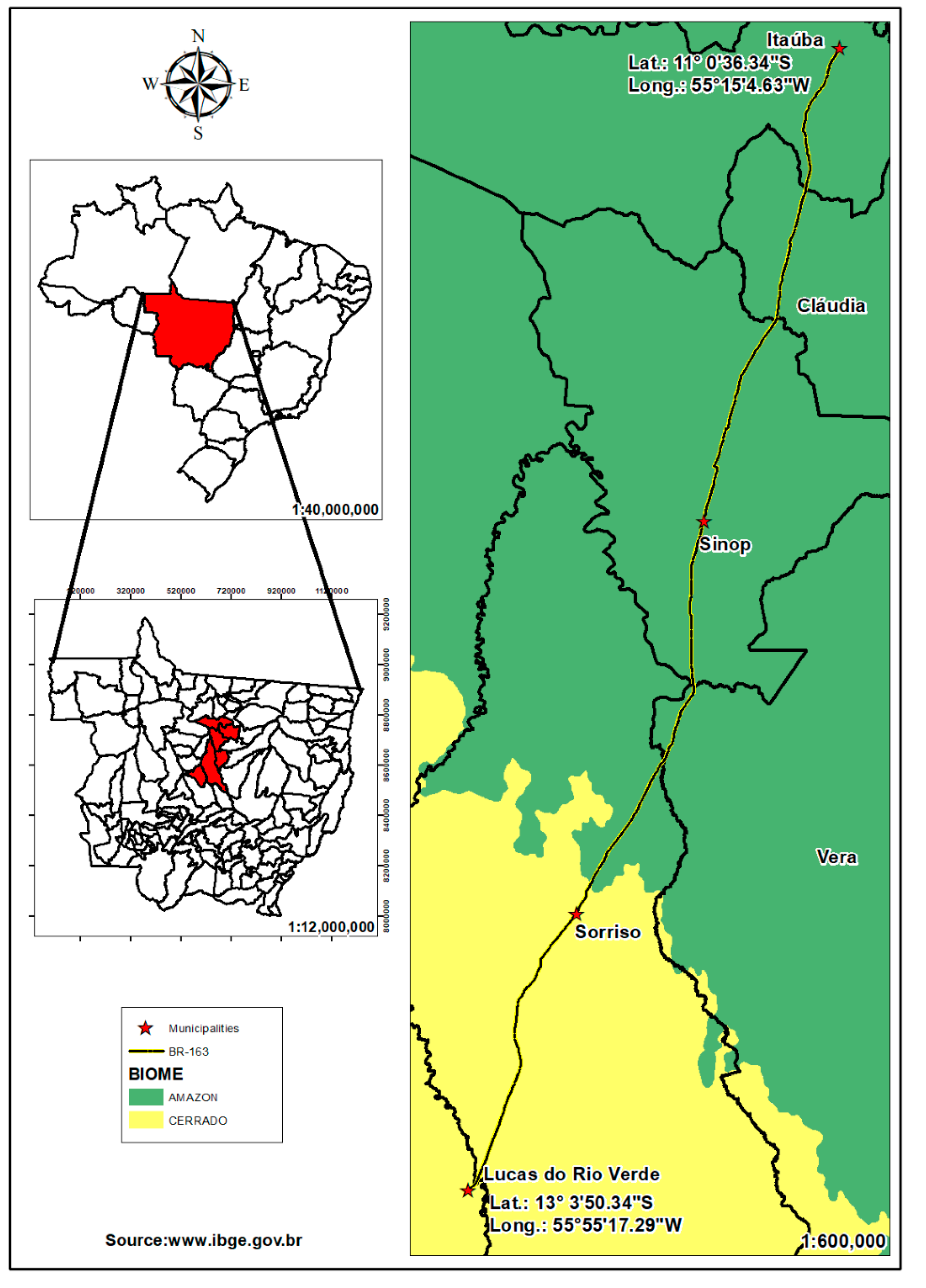
2.1. Study Area
2.2. Data Collection
2.3. Data Analysis
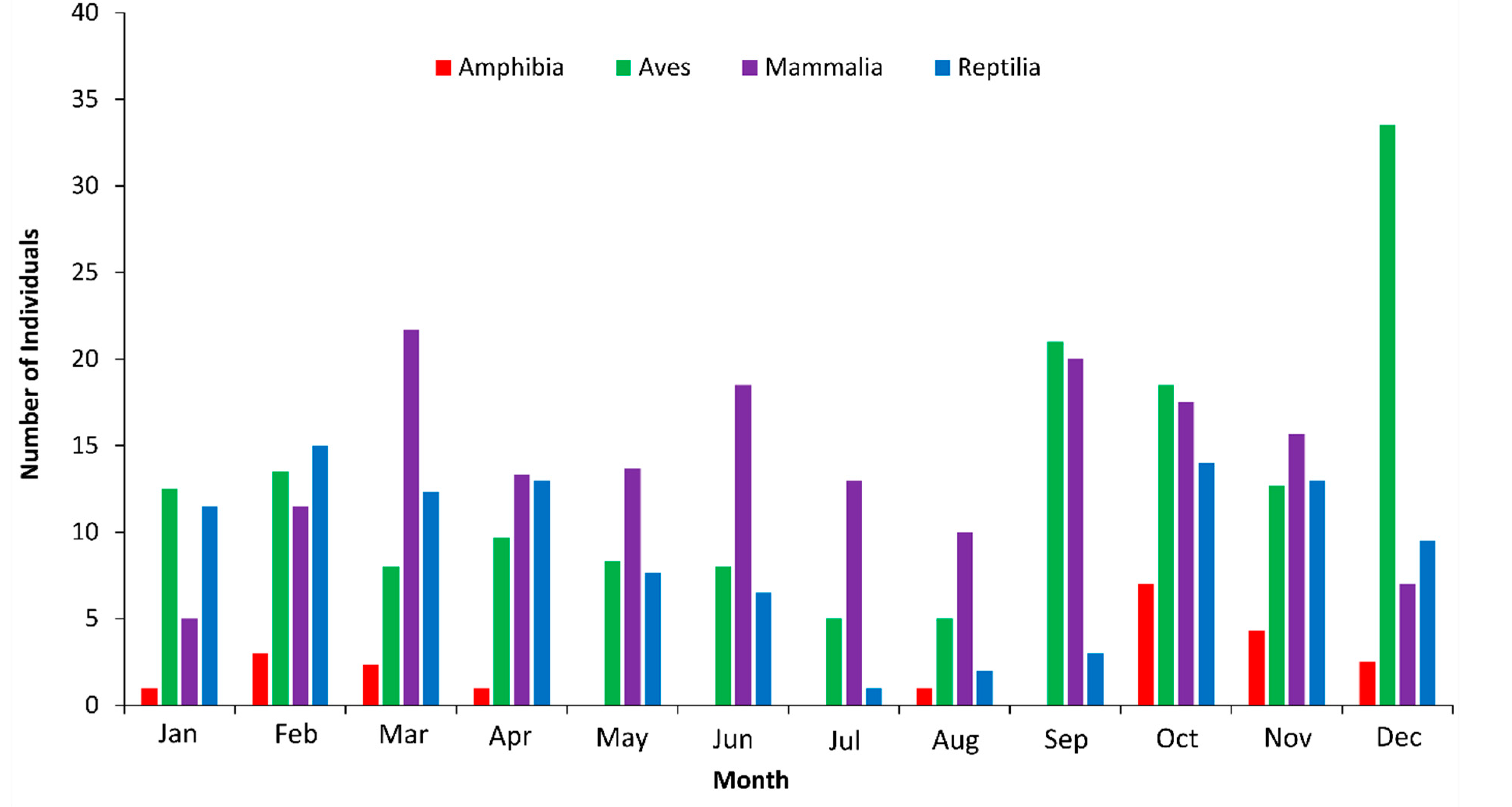
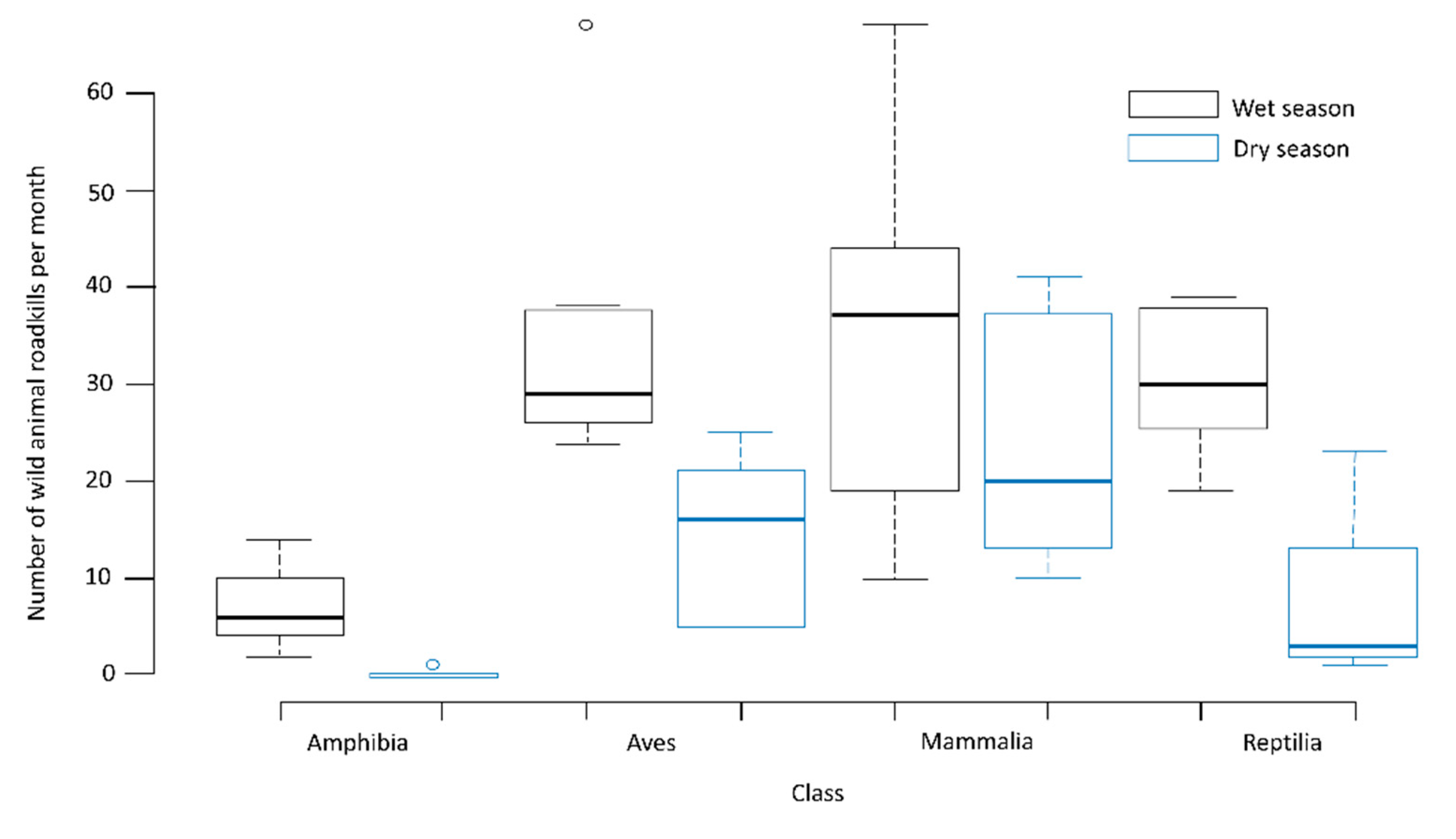
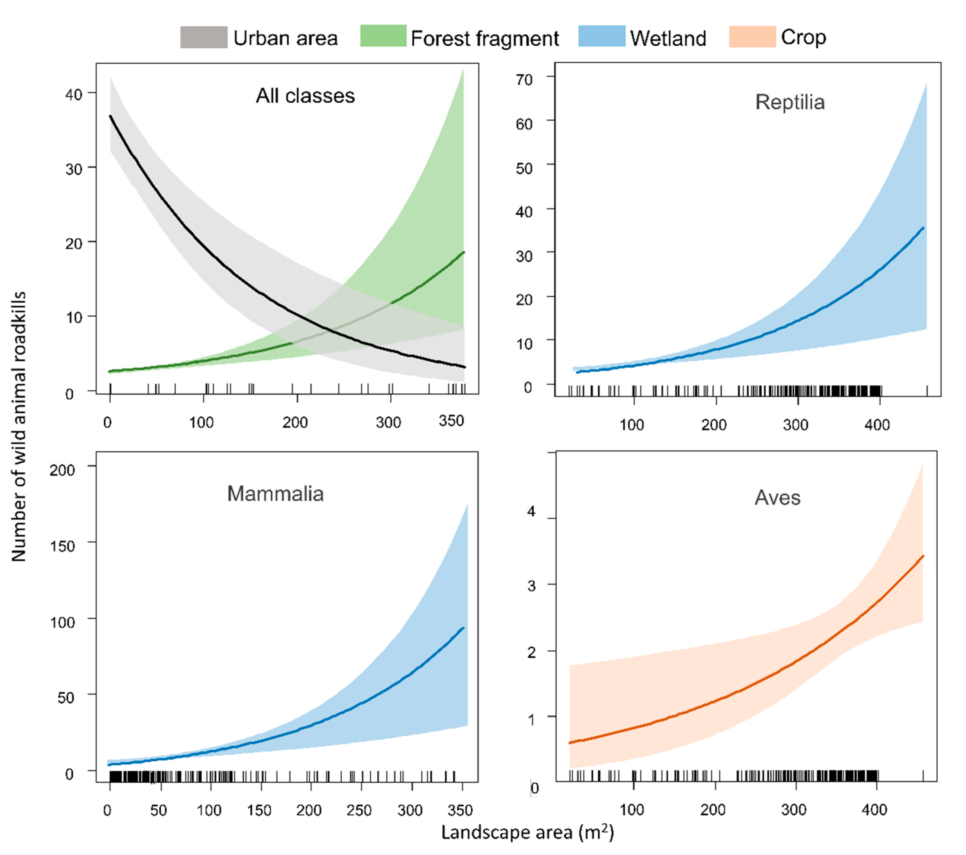
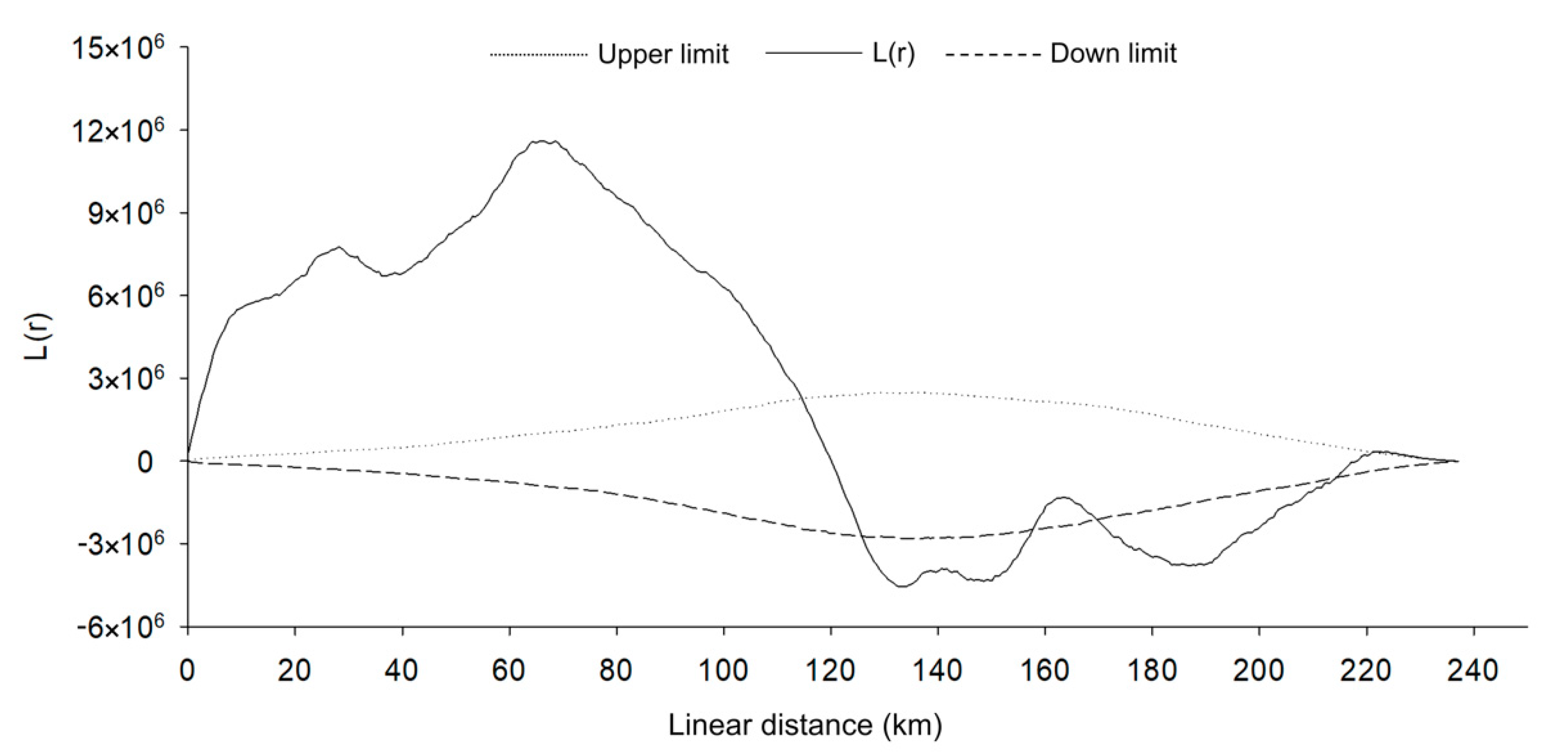
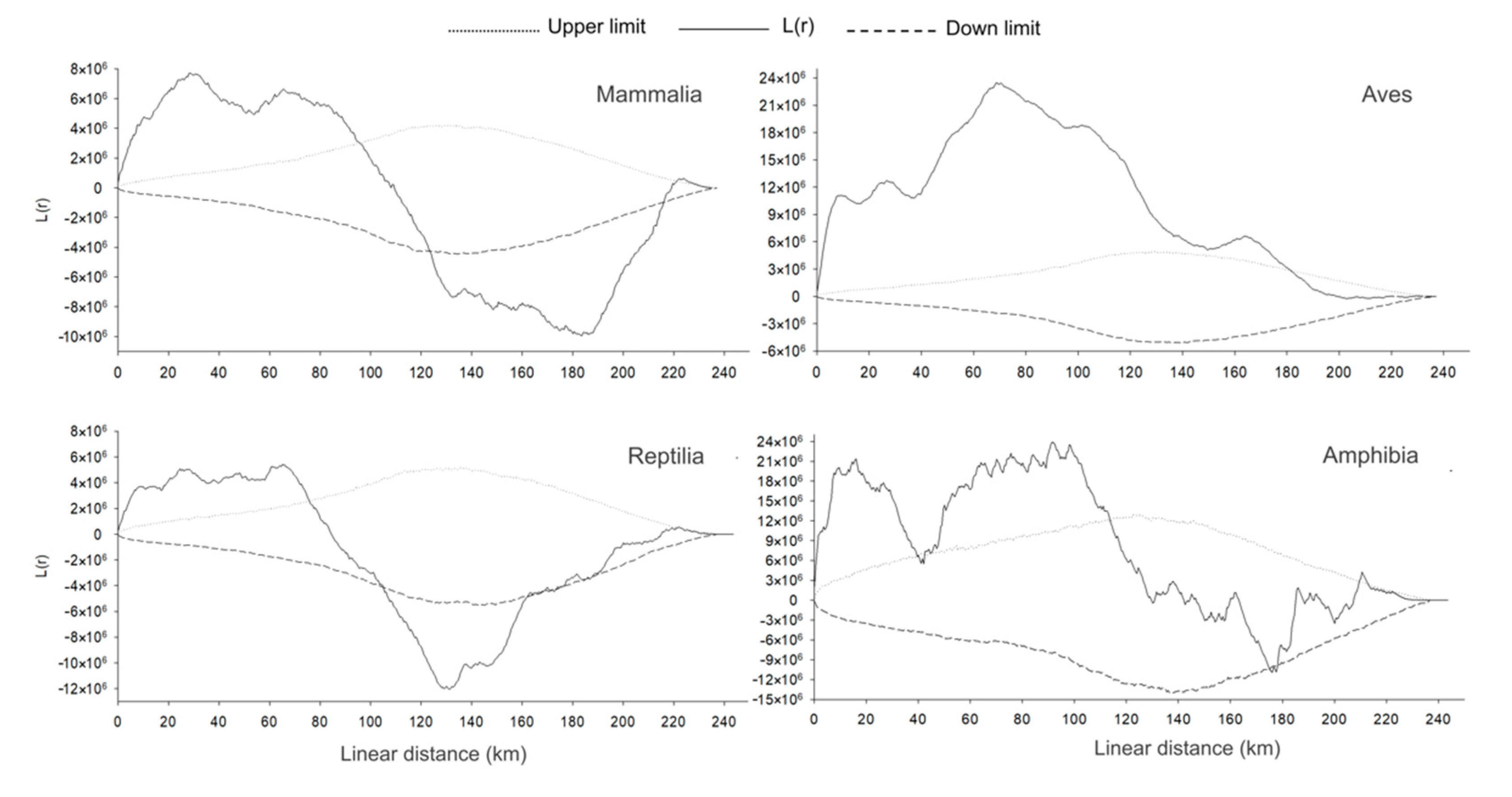
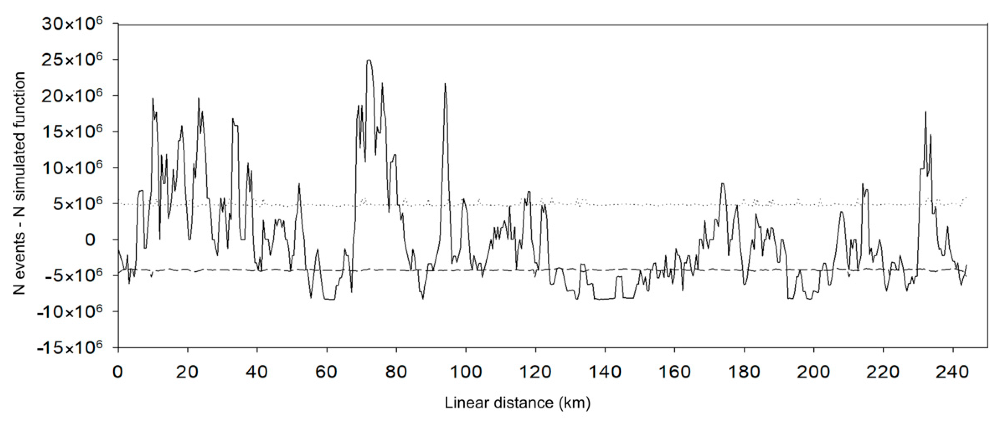
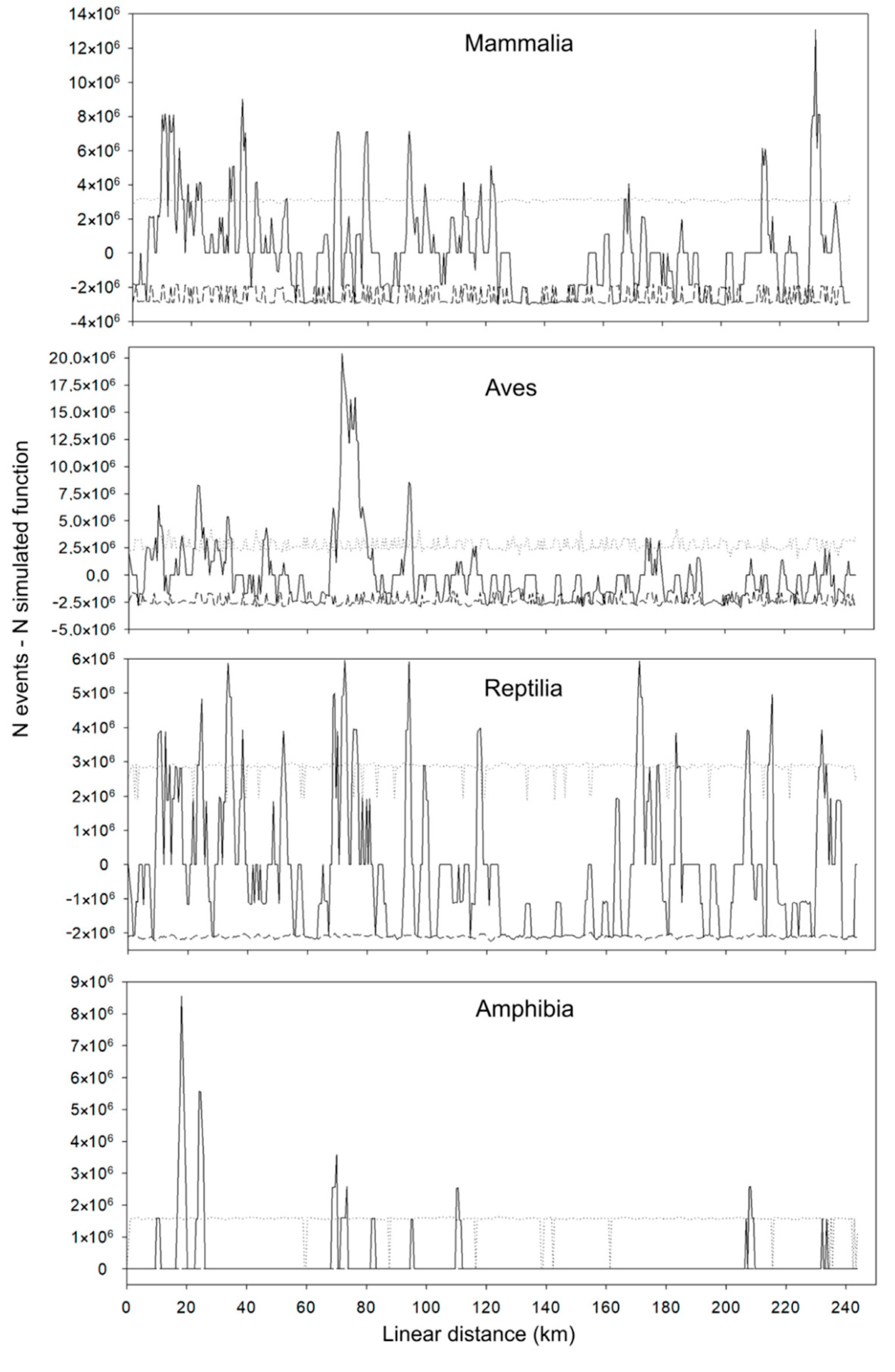
3. Results
4. Discussion
Author Contributions
Funding
Institutional Review Board Statement
Data Availability Statement
Acknowledgments
Conflicts of Interest
References
- Marengo, J.A.; Jimenez, J.C.; Espinoza, J.-C.; Cunha, A.P.; Aragão, L.E.O. Increased climate pressure on the agricultural frontier in the Eastern Amazonia–Cerrado transition zone. Sci. Rep. 2022, 12, 457. [Google Scholar] [CrossRef] [PubMed]
- Marques, E.Q.; Marimon-Junior, B.H.; Marimon, B.S.; Matricardi, E.A.T.; Mews, H.A.; Colli, G.R. Redefining the Cerrado–Amazonia transition: Implications for conservation. Biodivers. Conserv. 2020, 29, 1501–1517. [Google Scholar] [CrossRef]
- INPE-Projeto Prodes: Monitoramento da Floresta Amazônica Brasileira por Satélite. Available online: http://www.obt.inpe.br/OBT/assuntos/programas/amazonia/prodes (accessed on 6 June 2022).
- Rossi, F.S.; Santos, G.A.A.; Maria, L.S.; Lourenconi, T.; Pelissari, T.D.; Della-Silva, J.L.; Oliveira-Junior, J.W.; Silva, A.A.; Lima, M.G.; Teodoro, P.E.; et al. Carbon dioxide spatial variability and dynamics for contrasting land uses in central brazil agricultural frontier from remote sensing data. J. S. Am. Earth Sci. 2022, 116, 103809. [Google Scholar] [CrossRef]
- Arvor, D.; Margareth, M.; Dubreuil, V.; Bégué, A.; Shimabukuro, Y.E. Analysing the agricultural transition in Mato Grosso, Brazil, using satellite-derived indices. Appl. Geogr. 2012, 32, 702–713. [Google Scholar] [CrossRef]
- Macedo, M.N.; Fries, R.S.; Morton, D.C.; Stickler, C.M.; Galford, G.L.; Shimabukuro, Y.E. Decoupling of deforestation and soy production in the southern Amazon during the late 2000. Proc. Natl. Acad. Sci. USA 2012, 109, 1341–1346. [Google Scholar] [CrossRef]
- Ikeda, V.Y.; Adami, A.C.O.; Barros, G.S.C. Impact of soy exports from the North on market integration: The case of Paranaguá and Sorriso. Braz. J. Develop. 2020, 6, 79834–79855. [Google Scholar] [CrossRef]
- Margarit, E. The process of space occupation along the BR-163: A reading from the amazon’s strategic regional planningduring the military government. Geogr. Em Questão 2013, 6, 12–31. (In Portuguese) [Google Scholar] [CrossRef]
- Fearnside, P. Deforestation soars in the Amazon. Nature 2015, 521, 423. [Google Scholar] [CrossRef]
- Sivrikaya, F.; Günay, Ç.; Akay, A.E. Factors of land use/cover change: A case study from Turkey. Sci. Res. Essays 2011, 6, 3684–3696. [Google Scholar] [CrossRef]
- Domingues, M.S.; Bermann, C.; Sidneide, M. Soy production in Brazil and its relationship with deforestation in the Amazon. RPGeo 2014, 1, 32–47. (In Portuguese) [Google Scholar]
- Prada, C.S. Running over Wild Vertebrates in a Fragmented Region of the Northeast of the State of São Paulo: Quantification of the Impact and Analysis of Factors Involved. Master’s Dissertation, Universidade Federal de São Carlos, São Paulo, Brazil, 2004. (In Portuguese). [Google Scholar]
- Dulac, J. Global Land Transport Infrastructure Requirements: Estimating Road and Railway Infrastructure Capacity and Costs to 2050, 1st ed.; OECD/International Energy Agency: Paris, France, 2013; pp. 1–54. [Google Scholar]
- Ascensão, F.; Grilo, C.; LaPoint, S.; Tracey, J.; Clevenger, A.P.; Santos-Reis, M. Interindividual variability of Stone Marten behavioral responses to a highway. PLoS ONE 2014, 9, e103544. [Google Scholar] [CrossRef]
- Poessel, S.A.; Burdett, C.L.; Boydston, E.E.; Lyren, L.M.; Alonso, R.S.; Fisher, R.N.; Crooks, K.R. Roads influence movement and home ranges of a fragmentation-sensitive carnivore, the bobcat, in an urban landscape. Biol. Conserv. 2014, 180, 224–232. [Google Scholar] [CrossRef]
- Schwartz, A.L.W.; Shilling, F.M.; Perkins, S.E. The value of monitoring wildlife roadkill. Eur. J. Wildl. Res. 2020, 66, 18. [Google Scholar] [CrossRef]
- Laurance, W.F.; Croes, B.M.; Guissouegou, N.; Buij, R.; Dethier, M.; Alonso, A. Impacts of roads, hunting, and habitat alteration on nocturnal mammals in African rainforests. Conserv. Biol. 2008, 22, 721–732. [Google Scholar] [CrossRef] [PubMed]
- Laurance, W.F.; Goosem, M.; Laurance, S. Impacts of roads and linear clearings on tropical forests. Trends Ecol. Evol. 2009, 24, 659–669. [Google Scholar] [CrossRef] [PubMed]
- Avelar, E.R.; Silva, R.; Baptista, L.A.M.L. Threats to Wild Animal Survival in the State of Goiás. Uniciências 2015, 19, 132–140. (In Portuguese) [Google Scholar]
- Miranda, J.E.S.; Umetsu, R.K.; Melo, F.R.; Melo, F.C.S.A.; Kleber Fernando Pereira, K.F.; Oliveira, S.R. Roadkill in the Brazilian cerrado savanna: Comparing five highways in southwestern Goiás. Oecol. Aust. 2017, 21, 337–349. [Google Scholar] [CrossRef]
- Grilo, C.; Coimbra, M.R.; Cerqueira, R.C.; Barbosa, P.; Dornas, R.; Gonçalves, L.O.; Teixeira, F.Z.; Coelho, I.P.; Schmidt, B.R.; Pacheco, D.L.K.; et al. Brazil Road-kill: A data set of wildlife terrestrial vertebrate road kills. Ecology 2018, 99, 2625. [Google Scholar] [CrossRef] [PubMed]
- CBEE—Centro Brasileiro de Estudos em Ecologia de Estradas. Atropelômetro. Available online: http://cbee.ufla.br/portal/index.php (accessed on 2 July 2020).
- Cunha, H.F.; Moreira, F.G.A.; Silva, S. Roadkill of wild vertebrates along the GO-060 road between Goiânia and Iporá, Goiás State, Brazil. Acta Sci. Biol. Sci. 2010, 32, 257–263. [Google Scholar] [CrossRef]
- Grilo, C.; Bissonette, J.A.; Cramer, P.C. Mitigation measures to reduce impacts on biodiversity. In Highways: Constructions, Management and Maintenance; Jones, R.S., Ed.; Nova Science Publishers, Inc.: New York, NY, USA, 2010; pp. 73–114. [Google Scholar]
- Souza, V.E.; Somavilla, J.P.; Oliveira, J.S.; Schallemberger, L.F.; Buriol, G.A.; Domingues, A.L. Animais atropelados em um trecho da rodovia br-158, região central do Rio Grande do Sul. Discip. Sci. 2017, 18, 265–276. [Google Scholar]
- Jaeger, J.A.G.; Fahrig, L. Effects of Road fencing on population persistence. Conserv. Biol. 2004, 18, 1652–1657. [Google Scholar] [CrossRef]
- McGregor, R.L.; Bender, D.J.; Fahrig, L. Do small mammals avoid roads because of the traffic? J. Appl. Ecol. 2008, 45, 117–123. [Google Scholar] [CrossRef]
- Eigenbrod, F.; Hecnar, S.J.; Fahrig, L. Quantifying the road-effect zone: Threshold effects of a motorway on anuran populations in Ontario, Canada. Ecol. Soc. 2009, 14, 24. [Google Scholar] [CrossRef]
- Atwood, T.C.; Young, J.K.; Beckmann, J.P.; Breck, S.W.; Fike, J.; Rhodes-Jr, O.E.; Bristow, K.D. Modelling connectivity of black bears in a desert sky island archipelago. Biol. Conserv. 2011, 144, 2851–2862. [Google Scholar] [CrossRef]
- Pracucci, A.; Rosa, C.A.; Bager, A. Seasonal variation of the wildlife fauna run over on the road MG 354, Southern Minas Gerais —Brazil. Biotemas 2012, 25, 73–79. (In Portuguese) [Google Scholar] [CrossRef]
- Gumier-Costa, F.; Sperber, C.F. Roadkills of vertebrates in Carajas National Forest, Para, Brazil. Acta Amaz. 2009, 39, 459–466. (In Portuguese) [Google Scholar] [CrossRef]
- Freitas, C.H. Vertebrates Roadkills on Highways MG-428 and SP-334 with Analysis of Conditioning Factors and Economic Valuation of the Fauna. Ph.D. Thesis, Universidade Estadual Paulista, Rio Claro, Brazil, 2009. (In Portuguese). [Google Scholar]
- Cáceres, N.C.; Casella, J.; Goulart, C.S. Variação espacial e sazonal atropelamentos de mamíferos no bioma Cerrado, rodovia BR 262, Sudoeste do Brasil. Mastozool. Neotrop. 2012, 19, 21–33. [Google Scholar]
- Carvalho, C.F. Atropelamento de Vertebrados, Hotspots de Atropelamentos e Parâmetros Associados, BR-050, Trecho Uberlândia-Uberaba. Master’s Thesis, Universidade Federal de Uberlândia, Uberlândia, Brazil, 2014. [Google Scholar]
- Melo, E.S.; Santos-Filho, M. Effects of the BR-070 in the Serrana Province of Cáceres, Mato Grosso, on the wild vertebrate community. Rev. Bras. Zoociências 2007, 9, 185–192. (In Portuguese) [Google Scholar]
- Turci, L.C.B.; Bernande, P.S. Vertebrate roadkills on State Highway 383, Rondônia, Brazil. Biotemas 2009, 22, 121–127. (In Portuguese) [Google Scholar] [CrossRef]
- Pinheiro, B.F.; Turci, L.C.B. Roadkilled vertebrate on Variante highway (BR-307), Cruzeiro do Sul, Acre, Brazil. Nat. Line 2013, 11, 68–78. (In Portuguese) [Google Scholar]
- Bager, A.; Rosa, C.A. Influence of sampling effort on the estimated richness of road-killed vertebrate wildlife. Environ. Manag. 2011, 47, 851–858. [Google Scholar] [CrossRef]
- Coelho, I.P.; Kindel, A.; Coelho, A.V.P. Roadkills of vertebrate species on two highways through the Atlantic Forest Biosphere Reserve, southern Brazil. Eur J. Wildl. Res. 2008, 54, 689–699. [Google Scholar] [CrossRef]
- Teixeira, F.Z.; Coelho, I.P.; Esperandio, I.B.; Oliveira, N.R.; Peter, F.P.; Dorneles, S.S.; Delazeri, N.R.; Tavares, M.; Martins, M.B.; Kindel, A. Are road-kill hotspots coincident among different vertebrate groups? Oecol. Aust. 2013, 17, 36–47. [Google Scholar] [CrossRef]
- Glista, D.J.; DeVault, T.L.; DeWoody, J.A. A review of mitigation measures for reducing wildlife mortality on roadways. Landsc. Urban Plan. 2009, 91, 1–7. [Google Scholar] [CrossRef]
- Fischer, W.A. Effects of the BR-262 Highway on Wild Vertebrate Mortality: Naturalistic Synthesis for the Conservation of the Pantanal Region, MS. Master’s Dissertation, Universidade Federal de Mato Grosso do Sul, Campo Grande, Brazil, 1997. (In Portuguese). [Google Scholar]
- Hengemuhle, A.E.; Cademartori, C.V. Levantamento de Mortes de vertebrados silvestres devido a atropelamento em um trecho da estrada do mar (RS-389). Biodivers. Pampeana. 2008, 6, 4–10. [Google Scholar]
- Alvares, C.A.; Stape, J.L.; Sentelhas, P.C.; Moraes, G.; Leonardo, J.; Sparovek, G. Köppen’s climate classification map for Brazil. Meteorol. Z. 2013, 22, 711–728. [Google Scholar] [CrossRef]
- Souza, A.P.; Mota, L.L.; Zamadei, T.; Martin, C.C.; Almeida, F.T.; Paulino, J. Classificação climática e balanço hídrico climatológico no estado de Mato Grosso. Nativa 2013, 1, 34–43. [Google Scholar] [CrossRef]
- IME—Instituto Militar de Engenharia. Convênio IME/DNIT. Estudo de Viabilidade Técnico-Economica Concernentes à Construção da BR-163/MT/PA—Trecho: Guarantã do Norte-Santarém/PA. Relatório Do Estud. 2005, 1, 1–88. [Google Scholar]
- Lewinsohn, T.M.; Prado, P.I. How many species are there in Brazil? Megadiversidade 2005, 1, 36–42. (In Portuguese) [Google Scholar] [CrossRef]
- Hamada, N.; Nessimian, J.L.; Querino, R.B. Insetos Aquáticos na Amazônia Brasileira: Taxonomia, Biologia e Ecologia; Editora do INPA: Manaus, Brazil, 2014. [Google Scholar]
- Myers, N.; Mittermeier, R.; Mittermeier, C.G.; Fonseca, G.A.B.; Kent, J. Biodiversity hotspots for conservation priorities. Nature 2000, 403, 853–858. [Google Scholar] [CrossRef]
- Silva, J.M.C.; Bates, J.M. Biogeographic patterns andconservation in the South American Cerrado: A tropicalsavanna hotspot. Bio Sci. 2002, 52, 225–233. [Google Scholar] [CrossRef]
- Araújo, A.R.; Costa, R.B.; Felfili, J.M.; Gonçalvez, K.I.; Sousa, R.A.T.M.; Dorval, A. Floristics and structure of a forest fragment at a transitional zone at the Amazon in Mato Grosso State, Municipality of Sinop. Acta Amaz. 2009, 39, 865–877. [Google Scholar] [CrossRef]
- MapBiomas-Projeto MapBiomas—Coleção 6.0 da Série Anual de Mapas de Uso e Cobertura da Terra do Brasil. Available online: https://plataforma.brasil.mapbiomas.org (accessed on 11 May 2022).
- Marinho, H.M.; Candido, L.M.; Candido, A.S.; Daltro, O.; Jaudi, L.M.R.; Camargo, E.J.; Yoshida, P.S. Análise econômica da evolução do agronegócio em Mato Grosso no período de 1990 a 2010. Rev. Faipe 2016, 6, 13–24. [Google Scholar]
- Wang, Y.; Ziv, G.; Adami, M.; Mitchard, E.; Batterman, S.A.; Buermann, W.; Marimon, B.S.; Junior, B.H.M.; Reis, S.M.; Rodrigues, D.; et al. Mapping tropical disturbed forests using multi-decadal 30 m optical satellite imagery. Remote Sens. Environ. 2018, 221, 474–488. [Google Scholar] [CrossRef]
- Biudes, M.S.; Voulitis, G.L.; Machado, N.G.; Arruda, P.H.Z.; Neves, G.A.R.; Lobo, F.A.; Neale, C.M.U.; Nogueira, J.S. Patterns of energy exchange for tropical ecosystems across a climate gradient in Mato Grosso, Brazil. Agric. For. Meteorol. 2015, 202, 112–124. [Google Scholar] [CrossRef]
- Nogueira, E.M.; Fearnside, P.M.; Nelson, B.W.; França, M.B. Wood density in forests of Brazil’s ‘arc of deforestation’: Implications for biomass and flux of carbon from land-use change in Amazonia. For. Ecol. Manag. 2007, 248, 119–135. [Google Scholar] [CrossRef]
- Sigrist, T. Avifauna Brasileira: Pranchas e Mapas; São Paulo: Avis Brasilis, Brazil, 2009. [Google Scholar]
- Reis, N.R.; Peracchi, A.L.; Fregonezi, M.N.; Rossaneis, B.K. Mamíferos do Brasil-guia de Identificação; Technical Books Editora: Rio de Janeiro, Brazil, 2010. [Google Scholar]
- Costa, H.C.; Bérnils, R.S. Répteis do Brasil e suas Unidades Federativas: Lista de espécies. Herpetol. Bras. 2018, 7, 11–57. [Google Scholar]
- Segalla, M.; Berneck, B.; Canedo, C.; Caramaschi, U.; Cruz, C.A.G.; Garcia, P.C.A.; Grant, T.; Haddad, C.F.B.; Lourenço, A.; Mangia, S.; et al. Lista de Anfíbios do Brasil. Herpetol. Bras. 2021, 10, 122–226. [Google Scholar] [CrossRef]
- R Core Team. A Language and Environment for Statistical Computing; R Foundation for Statistical Computing: Vienna, Austria, 2021; Available online: http://www.R-project.org/ (accessed on 11 March 2022).
- Venables, W.N.; Ripley, B.D. Modern Applied Statistics with S, 4th ed.; Springer: New York, NY, USA, 2002. [Google Scholar]
- Burnham, K.P.; Anderson, D.R. Model Selection and Multimodel Inference: A Practical Information-Theoretic Approach, 2nd ed.; Springer: New York, NY, USA, 2002. [Google Scholar]
- Coelho, A.V.P.; Coelho, I.P.; Teixeira, F.T.; Kindel, A. Siriema: Road Mortality Software. Manual do Usuário V. 2.0; NERF; UFRGS: Porto Alegre, Brazil, 2014. [Google Scholar]
- Ripley, B.D. Spatial Statistics; John Wiley Sons: New York, NY, USA, 1981. [Google Scholar]
- Levine, N. CrimeStat III: A Spatial Statistics Program for the Analysis of Crime Incident Locations; Ned Levine & Associates: Houston, TX, USA; The National Institute of Justice: Washington, DC, USA, 2004. [Google Scholar]
- Clevenger, A.P.; Chruszcz, B.; Gunson, K.E. Spatial patterns and factors influencing small vertebrate fauna road-kill aggregations. Biol. Conserv. 2003, 109, 15–26. [Google Scholar] [CrossRef]
- Junior, R.O.; Lima, J.P.; Santos, A.L.W.; Aride, P.H.R. Caracterização da fauna de vertebrados atropelada na rodovia BR 174, Amazonas, Brasil. Rev. Colomb. Cienc. Anim. 2012, 4, 291–307. [Google Scholar] [CrossRef]
- Gunson, K.E.; Mountrakis, G.; Quackenbush, L.J. Spatial wildlife-vehicle collision models: A review of current work and its application to transportation mitigation projects. J. Environ. Manag. 2011, 92, 1074–1082. [Google Scholar] [CrossRef] [PubMed]
- Freitas, L.E. The Influence of Landscape Patterns on Fauna Roadkill: The Case of BR-040. Ph.D. Thesis, Universidade Federal do Rio de Janeiro, Rio de Janeiro, Brazil, 2012. (In Portuguese). [Google Scholar]
- Brum, T.R.; Santos-Filho, M.; Canale, G.R.; Ignácio, A.R.A. Effects of roads on the vertebrate’s diversity of the Indigenous Territory Paresi and its surrounding. Braz. J. Biol. 2018, 78, 125–132. [Google Scholar] [CrossRef] [PubMed]
- Cravo, A.P.B. Dos Impactos à Conservação de Fauna: A Implantação do Campus Lagoa do Sino e na Incidência de Atropelamentos de Animais Silvestres. Master’s Dissertation, Universidade Federal de São Carlos, São Carlos, Brazil, 2018. [Google Scholar]
- Prado, T.R.; Ferreira, A.A.; Guimarães, Z.F.S. Effect of the implantation of roads in the brazilian cerrado on the fauna of vertebrates. Acta Sci. Biol. Sci. 2006, 28, 237–241. [Google Scholar] [CrossRef]
- Azevedo, F.C.; Lemos, F.G.; Almeida, L.B.; Campos, C.B.; Beisiegel, B.M.; Paula, R.C.; Junior, R.G.C.; Ferraz, K.M.P.M.B.; Oliveira, T.G. Avaliação do risco de extinção da Onça-parda Puma concolor (Linnaeus, 1771) no Brasil. Biodivers. Bras. 2013, 1, 107–121. [Google Scholar]
- Pinowski, J. Roadkills of Vertebrates in Venezuela. Rev. Bras. Zool. 2005, 22, 191–196. [Google Scholar] [CrossRef]
- Roe, J.H.; Gibson, J.; Kingsbury, B.A. Beyond the wetland border: Estimating the impact of roads for two species of water snakes. Biol. Conserv. 2006, 130, 161–168. [Google Scholar] [CrossRef]
- Hartmann, P.A.; Hartmann, M.T.; Martins, M. Snake road mortality in a protected area in the Atlantic Forest of southeastern Brazil. South. Am. J. Herpetol. 2011, 6, 35–42. [Google Scholar] [CrossRef]
- Rosa, C.A.; Bager, A. Seasonality and habitat types affect roadkill of neotropical birds. J. Environ. Manag. 2012, 97, 1–5. [Google Scholar] [CrossRef] [PubMed]
- Forman, R.T.T.; Alexander, L.E. Roads and their major ecological effects. Annu. Rev. Ecol. Syst. 1998, 29, 207–231. [Google Scholar] [CrossRef]
- Fahrig, L.; Rytwinski, T. Effects of Roads on Animal Abundance: An Empirical Review. Ecol. Soc. 2009, 14, 21. [Google Scholar] [CrossRef]
- Casella, J. Influência da BR-262 no Desflorestamento e na Perda da Fauna Silvestre Por Atropelamentos no Sudoeste do Brasil, MS. Ph.D. Thesis, Universidade Federal de Mato Grosso do Sul, Campo Grande, Brazil, 2010. [Google Scholar]
- Frey, J.K.; Conover, M.R. Habitat use by meso-predators in a corridor environment. J. Wildl. Manag. 2006, 70, 1111–1118. [Google Scholar] [CrossRef]
- Dhindsa, M.S.; Sandhu, J.S.; Sandhu, P.S.; Toor, H.S. Roadside birds in Punjab (India): Relation to mortality from vehicles. Environ. Conserv. 1988, 15, 303–310. [Google Scholar] [CrossRef]
- Novelli, R.; Takase, E.; Castro, V. Estudo das aves mortas por atropelamento em um trecho da rodovia BR-471, entre os distritos da Quinta e Taim, Rio Grande do Sul, Brasil. Rev. Bras. Zool. 1988, 5, 441–454. [Google Scholar] [CrossRef]
- Milli, M.S.; Passamani, M. The impact of the Josil Espíndula Agostini Road (ES-249) on the mortality of wild animals (Vertebrata) by running over. Nat. Line 2006, 4, 40–46. [Google Scholar]
- Secco, H.K.C.; Ratton, P.; Castro, E.; Lucas, P.S.; Bager, A. Intentional snake road-kill: A case study using fake snakes on a Brazilian road introduction. Trop. Conserv. Sci. 2014, 7, 561–571. [Google Scholar] [CrossRef]
- Sullivan, B.K. Observed differences in body temperature and associated behaviour of four snake species. J. Herpetol. 1981, 15, 245–246. [Google Scholar] [CrossRef]
- Rosa, C.A.; Cardo, T.R.; Teixeira, F.Z.; Bager, A. Atropelamento de fauna selvagem: Amostragem e análise de dados em ecologia de estradas. In Ecologia de Estradas: Tendências e Pesquisas, 1st ed.; Bager, A., Ed.; Editora Lavras: Lavras, Brazil, 2012; pp. 79–99. [Google Scholar]
- Teixeira, F.Z.; Coelho, A.V.P.; Esperandio, I.B.; Kindel, A. Vertebrate road mortality estimates: Effects of sampling methods and carcass removal. Biol. Conserv. 2013, 157, 317–323. [Google Scholar] [CrossRef]


| Class | Family | Scientific Name | Number of Individuals | Roadkill Rate Ind./km/day | Status |
|---|---|---|---|---|---|
| Amphibia | Bufonidae | Rhinella marina (Linnaeus, 1758) | 17 | 0.0028 | LC |
| Leptodactylidae | Leptodactylus labyrinthicus (Spix, 1824) | 32 | 0.0052 | LC | |
| Ampibian n.i | Amphibian N.I. | 2 | 0.0003 | - | |
| Aves | Anatidae | Anas sp. | 1 | 0.0002 | - |
| Ardeidae | Butorides striata (Linnaeus, 1758) | 1 | 0.0002 | LC | |
| Cathartidae | Coragyps atratus (Bechstein, 1793) | 2 | 0.0003 | LC | |
| Charadriidae | Vanellus chilensis (Molina, 1782) | 1 | 0.0002 | LC | |
| Columbidae | Columbina talpacoti (Temminck, 1810) | 10 | 0.0016 | LC | |
| Patagioenas picazuro (Temminck, 1813) | 3 | 0.0005 | LC | ||
| Cuculidae | Crotophaga ani (Linnaeus, 1758) | 29 | 0.0048 | LC | |
| Guira guira (Gmelin, 1788) | 8 | 0.0013 | LC | ||
| Falconidae | Caracara plancus (Miller, 1777) | 3 | 0.0005 | LC | |
| Passeridae | Passer domesticus (Linnaeus, 1758) | 5 | 0.0008 | LC | |
| Psittacidae | Eupsittula aurea (Gmelin, 1788) | 6 | 0.0010 | LC | |
| Ramphastidae | Pteroglossus viridis(Linnaeus, 1766) | 1 | 0.0002 | LC | |
| Rheidae | Rhea americana (Linnaeus, 1758) | 5 | 0.0008 | NT | |
| Strigidae | Athene cunicularia (Molina, 1782) | 36 | 0.0059 | LC | |
| Thraupidae | Tangara cayana (Linnaeus, 1766) | 2 | 0.0003 | LC | |
| Volatinia jacarina (Linnaeus, 1766) | 13 | 0.0021 | LC | ||
| Tinamidae | Crypturellus sp. | 3 | 0.0005 | - | |
| Rhynchotus rufescens (Temminck, 1815) | 42 | 0.0069 | LC | ||
| Tyrannidae | Pitangus sulphuratus (Linnaeus, 1766) | 2 | 0.0003 | LC | |
| Tytonidae | Tyto furcata (Temminck,1827) | 83 | 0.0136 | LC | |
| Bird N.I. | Bird N.I. | 63 | 0.0103 | - | |
| Mammalia | Atelidae | Ateles marginatus (É. Geoffroy, 1809) * | 1 | 0.0002 | EN |
| Canidae | Cerdocyon thous (Linnaeus, 1766) | 95 | 0.0156 | LC | |
| Chrysocyon brachyurus (Illiger, 1815) * | 2 | 0.0003 | VU | ||
| Speothos venaticus (Lund, 1842) * | 1 | 0.0002 | VU | ||
| Caviidae | Cavia aperea Erxleben, 1777 | 2 | 0.0003 | LC | |
| Hydrochoerus hydrochaeris (Linnaeus, 1766) | 38 | 0.0062 | LC | ||
| Cebidae | Sapajus apella (Linnaeus, 1758) | 4 | 0.0007 | LC | |
| Chiroptera | Bats N.I. | 9 | 0.0015 | - | |
| Cricetidae | Bolomys sp. | 3 | 0.0005 | - | |
| Cuniculidae | Cuniculus paca (Linnaeus, 1766) | 2 | 0.0003 | LC | |
| Dasypodidae | Priodontes maximus (Kerr, 1792) * | 2 | 0.0003 | VU | |
| Dasypus novemcinctus Linnaeus, 1758 | 28 | 0.0046 | LC | ||
| Euphractus sexcinctus (Linnaeus, 1758) | 58 | 0.0095 | LC | ||
| Dasypodidae | Armadillo N.I. | 12 | 0.0020 | - | |
| Didelphidae | Didelphis sp. | 14 | 0.0023 | - | |
| Erethizontidae | Coendou prehensilis (Linnaeus, 1758) | 15 | 0.0025 | LC | |
| Felidae | Leopardus pardalis (Linnaeus, 1758) | 2 | 0.0003 | LC | |
| Puma concolor (Linnaeus, 1771) | 1 | 0.0002 | LC | ||
| Mustelidae | Eira barbara (Linnaeus, 1758) | 1 | 0.0002 | LC | |
| Lontra longicaudis (Olfers, 1818) | 1 | 0.0002 | NT | ||
| Pteronura brasiliensis (Zimmermann, 1780) * | 1 | 0.0002 | EN | ||
| Myrmecophagidae | Myrmecophaga tridactyla Linnaeus, 1758 * | 6 | 0.0010 | VU | |
| Tamandua tetradactyla (Linnaeus, 1758) | 32 | 0.0052 | LC | ||
| Procyonidae | Nasua nasua (Linnaeus, 1766) | 2 | 0.0003 | LC | |
| Procyon cancrivorus (G. Cuvier, 1798) | 2 | 0.0003 | LC | ||
| Tapiridae | Tapirus terrestris (Linnaeus, 1758)* | 2 | 0.0003 | VU | |
| Mammalia N.I. | Mammalia N.I. | 19 | 0.0031 | - | |
| Reptilia | Alligatoridae | Paleosuchus sp. | 6 | 0.0010 | - |
| Amphisbaenidae | Amphisbaena alba Linnaeus, 1758 | 4 | 0.0007 | LC | |
| Boidae | Boa constrictor constrictor (Linnaeus, 1758) | 58 | 0.0095 | LC | |
| Epicrates cenchria (Linnaeus, 1758) | 12 | 0.0020 | LC | ||
| Eunectes murinus (Linnaeus, 1758) | 9 | 0.0015 | LC | ||
| Colubridae | Clelia plúmbea (Wied, 1820) | 1 | 0.0002 | LC | |
| Oxyrrophus sp. | 3 | 0.0005 | - | ||
| Philodryas olfersii (Lichtenstein, 1823) | 7 | 0.0011 | LC | ||
| Spilotes pullatus (Linnaeus, 1758) | 8 | 0.0013 | LC | ||
| Elapidae | Micrurus sp. | 4 | 0.0007 | - | |
| Iguanidae | Iguana iguana (Linnaeus, 1758) | 1 | 0.0002 | LC | |
| Teiidae | Ameiva ameiva (Linnaeus, 1758) | 3 | 0.0005 | LC | |
| Tupinambis sp. | 6 | 0.0010 | - | ||
| Testudinidae | Chelonoidis carbonarius (Spix, 1824) | 2 | 0.0003 | NE | |
| Viperidae | Bothrops atrox (Linnaeus, 1758) | 2 | 0.0003 | LC | |
| Bothrops moojeni Hoge, 1966 | 7 | 0.0011 | LC | ||
| Crotalus durissus Linnaeus, 1758 | 1 | 0.0002 | LC | ||
| Reptilia N.I | Snake | 123 | 0.0202 | - | |
| N.I. | N.I. | N.I. | 23 | 0.0038 | - |
| Total | 1005 | 0.1648 |
Publisher’s Note: MDPI stays neutral with regard to jurisdictional claims in published maps and institutional affiliations. |
© 2022 by the authors. Licensee MDPI, Basel, Switzerland. This article is an open access article distributed under the terms and conditions of the Creative Commons Attribution (CC BY) license (https://creativecommons.org/licenses/by/4.0/).
Share and Cite
Santos, E.; Cordova, M.; Rosa, C.; Rodrigues, D. Hotspots and Season Related to Wildlife Roadkill in the Amazonia–Cerrado Transition. Diversity 2022, 14, 657. https://doi.org/10.3390/d14080657
Santos E, Cordova M, Rosa C, Rodrigues D. Hotspots and Season Related to Wildlife Roadkill in the Amazonia–Cerrado Transition. Diversity. 2022; 14(8):657. https://doi.org/10.3390/d14080657
Chicago/Turabian StyleSantos, Evandro, Milton Cordova, Clarissa Rosa, and Domingos Rodrigues. 2022. "Hotspots and Season Related to Wildlife Roadkill in the Amazonia–Cerrado Transition" Diversity 14, no. 8: 657. https://doi.org/10.3390/d14080657