Natural Regeneration of the Mangrove Vegetation on Abandoned Salt Ponds in Ceará, in the Semi-Arid Region of Northeastern Brazil

 , and
, and 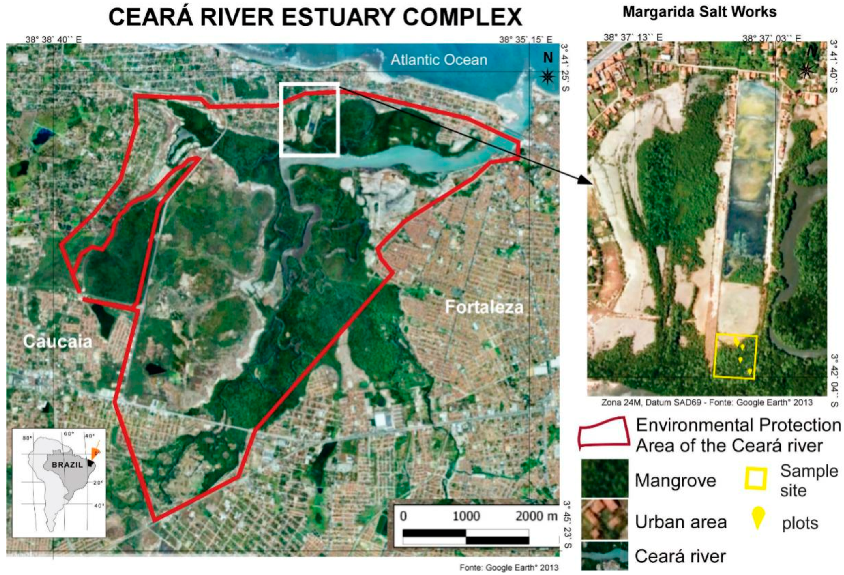
Abstract
:1. Introduction
2. Location of the Study Area and Methods
2.1. Remote Sensing and Mangrove Vegetation Structure
2.2. Analysis of the State Legislation
3. Results and Discussion
3.1. Analysis of the Spatiotemporal Evolution of the Mangroves of the Ceará River
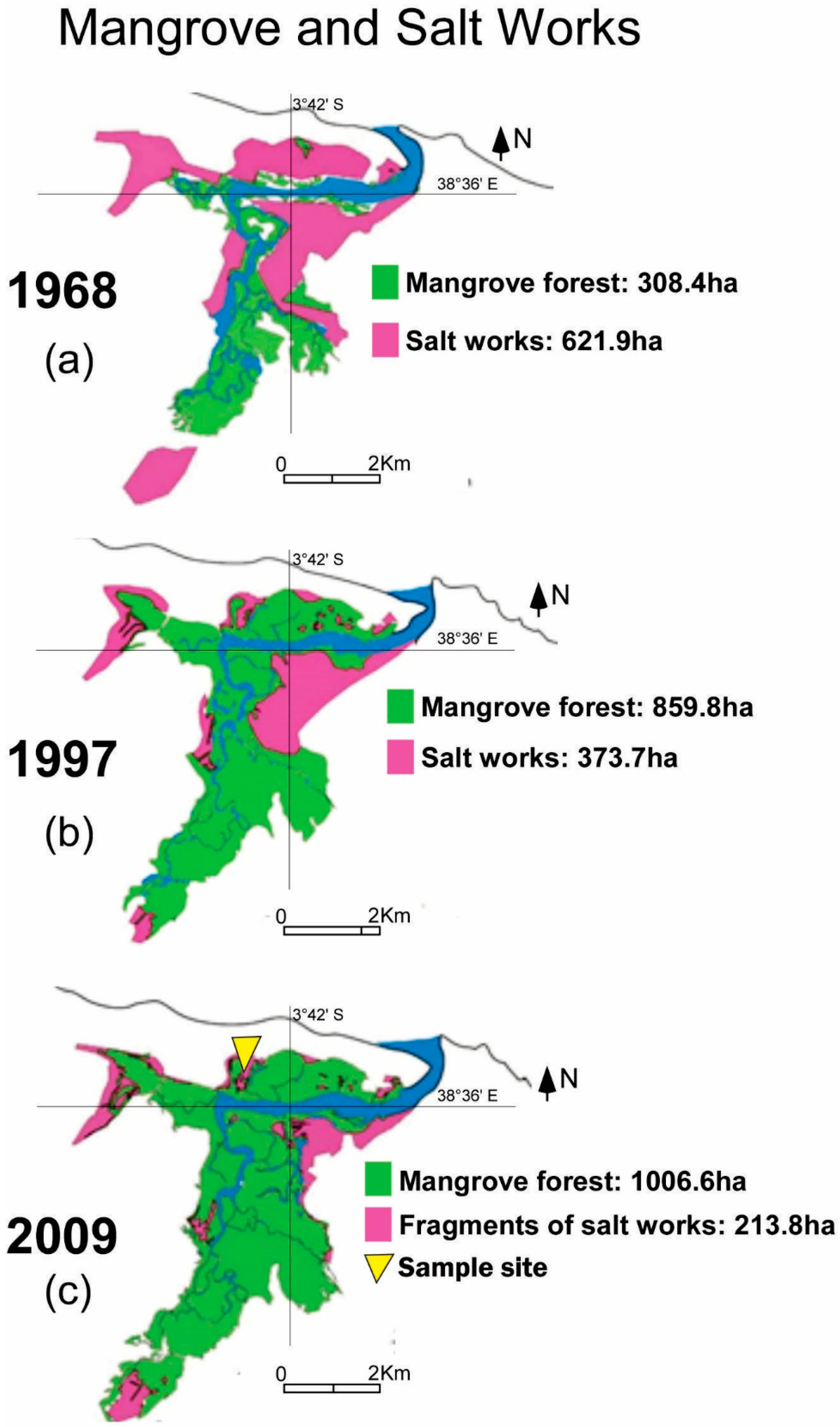
3.1.1. Period I: 1968–1997
3.1.2. Period II: 1997–2009
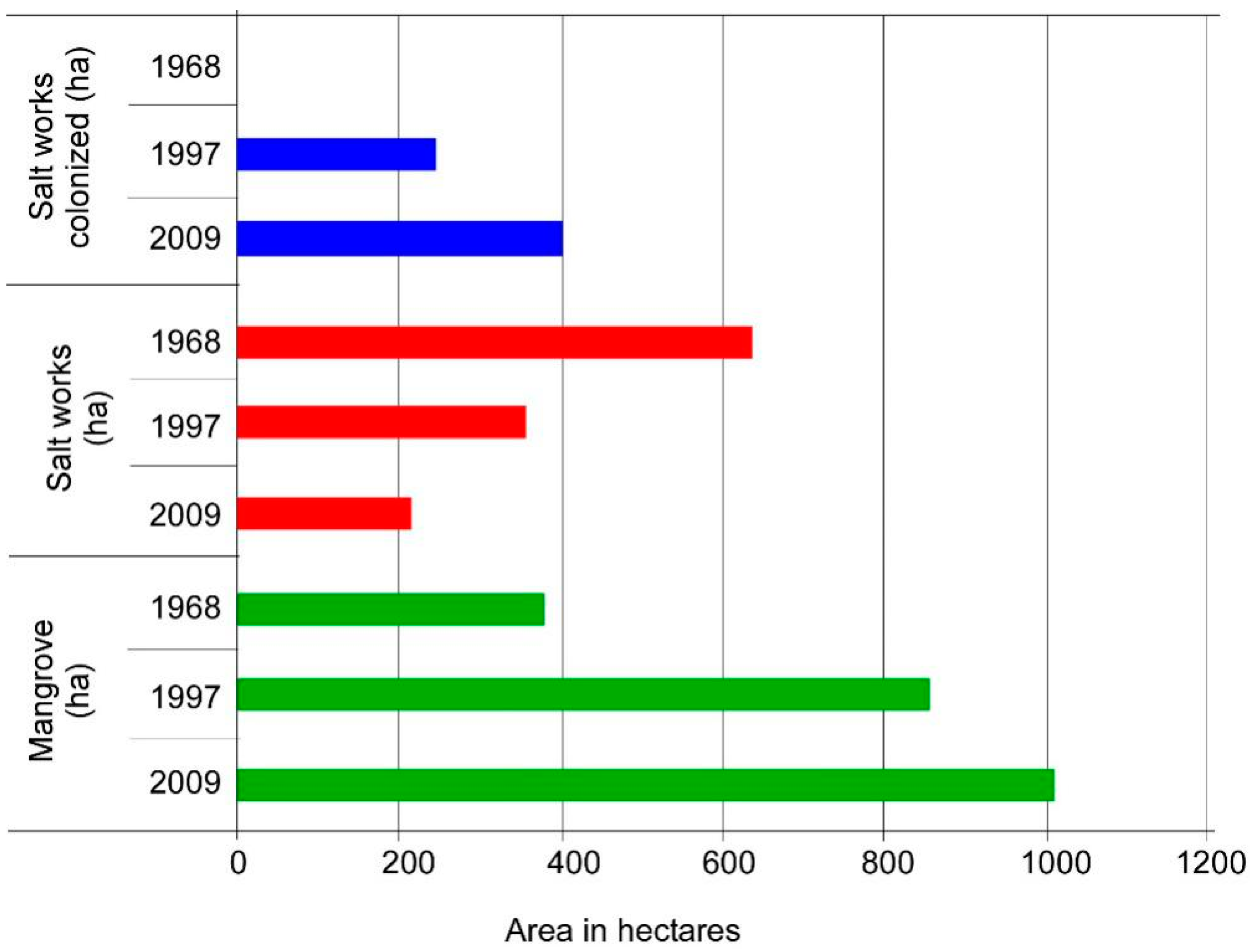
3.1.3. Comparative analysis of periods I (1968–1997) and II (1997–2009)
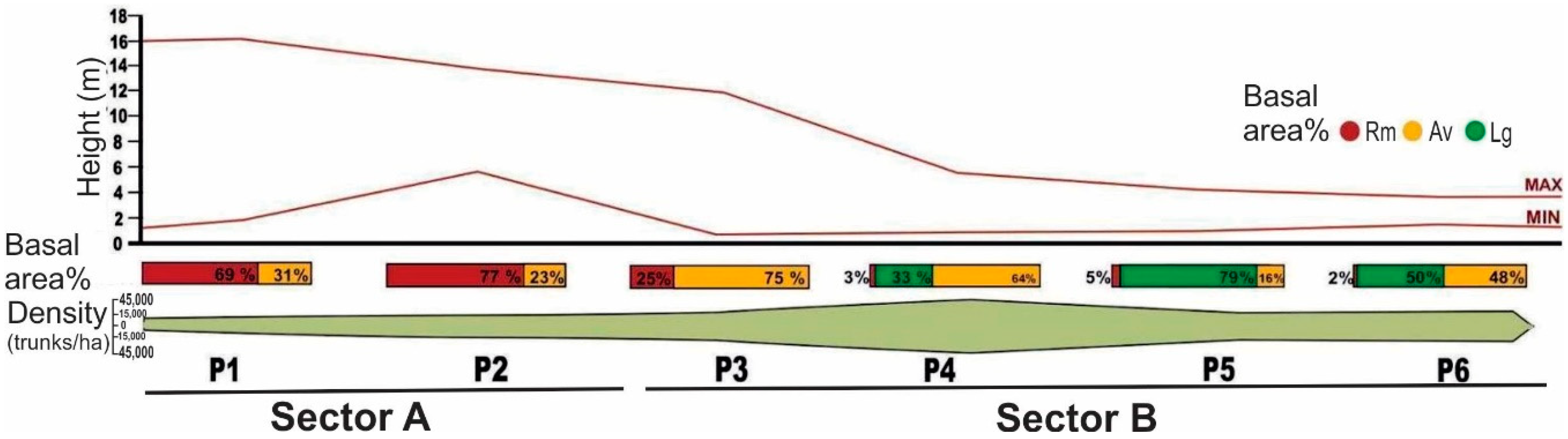
3.2. Dynamics of the Mangrove Forest in the Area of the Margarida Saltworks
3.3. Brazilian Environmental Legislation and the Mangrove
4. Conclusions
Author Contributions
Funding
Acknowledgments
Conflicts of Interest
References
- Giri, C.; Ochieng, E.; Tieszen, L.L.; Zhu, Z.; Singh, A.; Loveland, T.; Masek, J.; Duke, N. Status and distribution of mangrove forests of the world using earth observation satellite data. Glob. Ecol. Biogeogr. 2011, 20, 154–159. [Google Scholar] [CrossRef]
- Feller, I.C.; Lovelock, C.E.; Berger, U.; Mckee, K.L.; Joye, S.B.; Ball, M.C. Biocomplexity in Mangrove Ecosystem. Annu. Rev. Mar. Sci. 2010, 2, 395–417. [Google Scholar] [CrossRef] [PubMed]
- Schaeffer-Novelli, Y.; Cintrón-Molero, G.; Molero, G.; Soares, M.L.; De-Rosa, M.M.P.T. Brazilian mangroves. Aquat. Ecosyst. Health Manag. 2000, 3, 561–570. [Google Scholar] [CrossRef]
- Jablonski, S.; Filet, M. Coastal management in Brazil—A political riddle. Ocean Coast Manag. 2008, 51, 536–543. [Google Scholar] [CrossRef]
- ICMBio. Atlas dos Manguezais Brasileiros; ICMBio: Brasília, Brasil, 2018; p. 176.
- Schaeffer-Novelli, Y.; Cintrón-Molero, G.; Camargo, R.R.A.T.M. Variability of Mangrove Ecosystem along the Brazilian Coast. Estuar. Res. Fed. 1990, 13, 204–218. [Google Scholar] [CrossRef]
- Rocha, R.M.; Da Silva, C.D.F.; De Lucena, F.M.A.; Bezerra, R.M.; De Medeiros, D.H.M.; Da Silva, A.M.A.; De Araújo, C.N.; Xavier-Filho, L. Tropical solar saltworks–influence and challenges in the coexistence with traditional population in the Brazilian northeast region. In Proceedings of the 9th International Symposium on Salt, Beijing, China, 4–7 September 2009; p. 4-1. [Google Scholar]
- Maia, M.T.A. Circuito Espacial de Produção de Sal: O uso do Território do Município de Macau/RN Pelas Indústrias Salineiras. Master’s Thesis, Universidade Federal do Rio Grande do Norte, Natal, Brazil, 2011; p. 161.
- Da Silva Costa, D.F.; Adailson da Silva, A.; Miranda Medeiros, D.H.; Araújo Lucena Filho, M.; De Medeiros Rocha, R.; Lillebo, A.I.; Soares, A.M. Breve revisão sobre a evolução histórica da atividade salineira no Estado do Rio Grande do Norte (Brasil). Soc. Nat. 2013, 25, 21–34. [Google Scholar] [CrossRef]
- Resolução do Conselho Estadual do Meio Ambiente (COEMA). Resolução n° 02/2002. Estabelece as Normas Regulamentadoras dos Procedimentos de Licenciamento Environmental para Empreendimentos de Carcinicultura Terrestre; Publicada em Diário Oficial (DOE): Fortaleza, CE, Brazil, 2002.
- Lacerda, L.D.; Menezes, M.O.T.; Molisani, M.M. Changes in mangrove extension at the Pacoti River estuary, Ce, NE Brazil due to regional environmental changes between 1958 and 2004. Biota Neotrop. 2007, 7, 67–72. [Google Scholar] [CrossRef]
- Meireles, A.J.A.; Silva, E.V.; Thiers, P.R.L.T. Impactos Ambientais das atividades de carcinicultura no ecossistema Manguezal do Estado do Ceará, Nordeste do Brasil. Rev. Gest. Costeira Integr. 2010, 2, 1–11. [Google Scholar]
- Reis-Neto, A.S.; Cunha-Lignon, M.; Arruda-Reis, M.C.C.; Meireles, A.J.A. The Ceara River Mangrove’s landscape (northeast Brazil): Comparative analyses of 1968 and 2009. J. Coast. Res. 2011, 2, 1802–1805. [Google Scholar]
- Reis-Neto, A.S.; Meireles, A.J.A.; Cunha-Lignon, M. Analyses of the mangrove´s rehabilitation process in abandoned saltwork area, in the Ceará river, Northeast Brazil. Int. J. Appl. Nat. Sci. 2013, 2, 27–35. [Google Scholar]
- Constanza, R.; D’arge, R.; De Groot, R.S.; Farber, S.; Grasso, M.; Hannon, B.; Limburg, K.; Naeem, S.; O’neill, R.V.; Paruelo, J.; et al. The value of the world’s ecosystem services and natural capital. Nature 1997, 387, 253–260. [Google Scholar] [CrossRef]
- Queiroz, L.S.; Rossi, S.; Calvet-Mir, L.; Ruiz-Mallen, I.; Garcia-Betorz, S.; Salva-Prat, J.; Meireles, A.J.A. Neglected ecosystem services: Highlighting the socio-cultural perception of mangroves in decision-making processes. Ecosyst. Serv. 2017, 26, 137–145. [Google Scholar] [CrossRef]
- Molisani, M.M.; Cruz, A.L.V.; Maia, L.P. Estimativa da descarga fluvial para os estuários do Estado do Ceará. Bras. Arq. Ciênc. Mar 2006, 39, 53–60. [Google Scholar]
- Funceme-Fundação Cearense de Meteorologia e Recursos Hidricos. Previsão de Afluências. Available online: http://www.funceme.br/index.php/29-produtos-e-servicos/previs%C3%A3o/hidrol%C3%B3gico/419-previsao-sazonal-de-afluencias (accessed on 21 July 2012).
- Martins, E.S.P.R.; Vasconcelos Júnior, S.C. O clima da Região Nordeste entre 2009 e 2017: Monitoramento e previsão. Parcer. Estratég. 2017, 22, 63–80. [Google Scholar]
- Guedes, R.L.; Andreoli, R.V.; Kayano, M.T.; Oyama, M.D.; Alves, M.A.S. Série Temporal de precipitação mensalt em Fortaleza, Brasil: Comparação entre observações e dados de reanalysis do NCEP/NCAR. Rev. Bras. Metereol. 2005, 20, 83–92. [Google Scholar]
- de Andrade Meireles, A.J.; Campos, A.A. Componentes Geomorfológicos, Funções e Serviços Environmental de Complexos Estuarinos no Nordeste do Brasil. Rev. Assoc. Nac. Pós-Grad. Pesqui. Geogr. 2010, 4, 89–107. [Google Scholar]
- Heumann, B.W. Satellite remote sensing of mangrove forest: Recent advances and future opportunities. Prog. Phys. Geogr. 2011, 35, 87–108. [Google Scholar] [CrossRef]
- Freitas, D.M.; Tagliani, P.R.A. The use of GIS for the integration of traditional and scientific knowledge in supporting artisanal fisheries management in Southern Brazil. J. Environ. Manag. 2009, 90, 2071–2080. [Google Scholar] [CrossRef] [PubMed]
- Jensen, J.R. Remote Sensing of the Environment: An Earth Resource Perspective, 2nd ed.; Pearson: Boulder, CO, USA, 2007. [Google Scholar]
- Cunha-Lignon, M.; Menghini, R.P.; Santos, L.C.M.; Niemeyer-Dinóla, C.; Scharffer-Novelli, Y. Estudos de caso nos manguezais do Estado de São Paulo (Brasil): Aplicação de Ferramentas com diferentes escalas Espaçotemporais. Rev. Gest. Costeira 2009, 9, 79–91. [Google Scholar] [CrossRef]
- Schaeffer-Novelli, Y.; Vale, C.C.; Cintrón, G. Monitoramento do Ecossistema Manguezal: Estrutura e características funcionais. In Protocolos de Campo para o Monitoramento de Habitats Bentônicos Costeiros: Rede de Monitoramento de Habitats Bentônicos Costeiros—ReBentos; Turra, A., Dedanai, M.R., Eds.; IOUSP: São Paulo, SP, Brazil, 2015; Chapter 4; pp. 65–83. 255p. [Google Scholar]
- Meireles, A.J.A.; Cassola, R.S.; Tupinambá, S.V.; de Queroz, L.S. Impactos environmental decorrentes das atividades da carcinicultura ao longo do litoral cearense, nordeste do Brasil. Rev. Mercat. 2007, 1, 83–106. [Google Scholar]
- Elster, C.; Perdomo, L. Rooting and vegetative propagation in Laguncularia racemosa. Aquat. Bot. 1999, l63, 83–93. [Google Scholar] [CrossRef]
- Rovai, A.S.; Soriano-Sierra, E.J.; Pagliosa, P.R.; Cintrón, G.; Schaeffer-Novelli, Y.; Menghini, R.P.; Coelho, C., Jr.; Horta, P.A.; Lewis, R.R., III; Simonassi, J.C.; et al. Secondary sucession impairment in restored mangroves. Wetl. Ecol. Manag. 2012, 20, 447–459. [Google Scholar] [CrossRef]
- Field, C.B.; Osborn, J.G.; Hoffman, L.L.; Polsenberg, J.F.; Ackerly, D.D.; Berry, J.A.; Björkman, O.; Held, A.; Matson, P.A.; Mooney, H.A. Mangrove biodiversity and ecosystem function. Glob. Ecol. Biogeogr. Lett. 1998, 7, 3–14. [Google Scholar] [CrossRef]
- BRASIL. Lei Federal no 4.771, de 15 de Setembro de 1965, que Institui o Código Florestal Brasileiro; Publicada no Diário Oficial da União: Brasília, DF, Brasil, 1965.
- BRASIL. Lei Federal no 7.661, de 16 de Maio de 1988, que Institui o Plano Nacional de Gerenciamento da Zona Costeira (PNGC); Publicada no Diário Oficial da União: Brasília, DF, Brasil, 1988.
- BRASIL. Lei Federal no 12.651, de 25 de Maio de 2012, que Institui o Código Florestal Brasileiro; Publicada no Diário Oficial da União: Brasília, DF, Brasil, 2012.
- FAO. The World’s Mangroves 1980–2005; FAO Forestry Paper 153; FAO: Rome, Italy, 2007; 78p. [Google Scholar]
- Kumar, P. The Economics of Ecosystems and Biodiversity: Ecological and Economic Foundations; An output of TEEB: The Economics of Ecosystems and Biodiversity; Earthscan: London, UK, 2010; 410p. [Google Scholar]
- Queiroz, L.S.; Rossi, S.; Meireles, A.J.A.; Coelho, C. Shrimp aquaculture in the federal state of Ceará, 1970–2012: Trends after mangrove forest privatization in Brazil. Ocean Coast. Manag. 2013, 73, 54–62. [Google Scholar] [CrossRef]
- IBAMA—Instituto Brasileiro do Meio Ambiente e Recursos Renováveis. Diagnóstico da Carcinicultura no Estado do Ceará, Relatório Final; Diretoria de Proteção Environmental (DIPRO), Diretoria de Licenciamento e Qualidade Environmental (DILIQ) e Gerência Executiva do Ceará (GEREX-CE): Fortaleza, CE, Brasil, 2005; Volume I, 177p.
- Albuquerque, A.G.B.M.; Ferreira, T.O.; Nóbrega, G.N.; Romero, R.E.; Júnior, V.S.; Meireles, A.J.A.; Otero, X.L. Soil genesis on hypersaline tidal flats (apicum ecosystem) in a tropical semi-arid estuary (Ceará, Brazil). Soil Res. 2014, 52, 140–154. [Google Scholar] [CrossRef]
- Barbier, E.B.; Strand, I. Valuing mangrove fishery linkages: A case study of Campeche, Mexico. Environ. Resour. Econ. 1998, 12, 151–166. [Google Scholar] [CrossRef]
- Mäler, K.G.; Aniyar, S.; Jansson, A. Accounting for ecosystem services as a way to understand the requirements for sustainable development. Proc. Natl. Acad. Sci. USA 2008, 105, 9501–9506. [Google Scholar] [CrossRef] [PubMed] [Green Version]


© 2019 by the authors. Licensee MDPI, Basel, Switzerland. This article is an open access article distributed under the terms and conditions of the Creative Commons Attribution (CC BY) license (http://creativecommons.org/licenses/by/4.0/).
Share and Cite
Reis-Neto, A.S.d.; Meireles, A.J.d.A.; Cunha-Lignon, M. Natural Regeneration of the Mangrove Vegetation on Abandoned Salt Ponds in Ceará, in the Semi-Arid Region of Northeastern Brazil. Diversity 2019, 11, 27. https://doi.org/10.3390/d11020027
Reis-Neto ASd, Meireles AJdA, Cunha-Lignon M. Natural Regeneration of the Mangrove Vegetation on Abandoned Salt Ponds in Ceará, in the Semi-Arid Region of Northeastern Brazil. Diversity. 2019; 11(2):27. https://doi.org/10.3390/d11020027
Chicago/Turabian StyleReis-Neto, Armando Soares dos, Antonio Jeovah de Andrade Meireles, and Marília Cunha-Lignon. 2019. "Natural Regeneration of the Mangrove Vegetation on Abandoned Salt Ponds in Ceará, in the Semi-Arid Region of Northeastern Brazil" Diversity 11, no. 2: 27. https://doi.org/10.3390/d11020027