1. Introduction
By definition, biomes are regions of the planet that can be distinguished by their geography, climate, and associated flora and fauna. They are classified according to the predominant vegetation and characterized by the particular adaptations of the organisms to the climatic features [
1].
Brazil is considered a megadiverse country possessing six terrestrial biomes—Amazonia, Atlantic Forest, Caatinga, Cerrado, Pantanal and Pampa (
Figure 1a). The Amazonia biome comprises about 49.29% of the Brazilian territory occupying an approximate area of 4,196,943 km
2. This biome is considered one of the most important areas on earth. It represents half of the world’s rainforest and is home of one third of the Earth’s species. Moreover, the Amazonia biome is a critical global storehouse of carbon [
2]. Estimates indicate that a typical forest of the region contains, on average, 460 tons of biomass per hectare, which corresponds to 230 tons of carbon fixed in plant tissues [
2]. For those reasons, the Brazilian Amazon is one of the most studied and important biomes in the world. The Cerrado is the second biggest Brazilian biome and encompasses 2,036,448 km
2, accounting for about 23.92% of the country’s land area. This biome is a vast savanna ecoregion, dry and hot, but far from lifeless, comprising a wide range of plant and animal biodiversity, described as the richest savanna of the world by the World Wildlife Fund. Over the past 35 years, more than half of the Cerrado’s original area has been converted to agriculture, which represents a dramatic change in Brazilian land use. The Atlantic Forest stretches along Brazil’s Atlantic Coast, occupying 1,110,182 km
2 of the total area and representing about 13.04% of the national territory. The Atlantic Forest has shrunk to only 7% of its original range, due to the encroachment of anthropogenic activities. The Caatinga biome consists primarily of xeric shrubland and thorn forest, and covers the northeast portion of Brazil and occupies 9.92% of the country’s area (844,453 km
2). In terms of the country’s land area, the Pantanal biome and the Pampa biome are the smallest in Brazil. The Pantanal consists of a tropical wetland in which periods of inundation and desiccation alternate annually. In spite of this, the area supports both a rich agricultural and ecotourism economy. It occupies about 150,355 km
2, which represents 1.76% of the national territory. The Brazilian Pampa biome is slightly larger, occupying an area of 176,496 km
2, representing about 2.07% of the national territory.
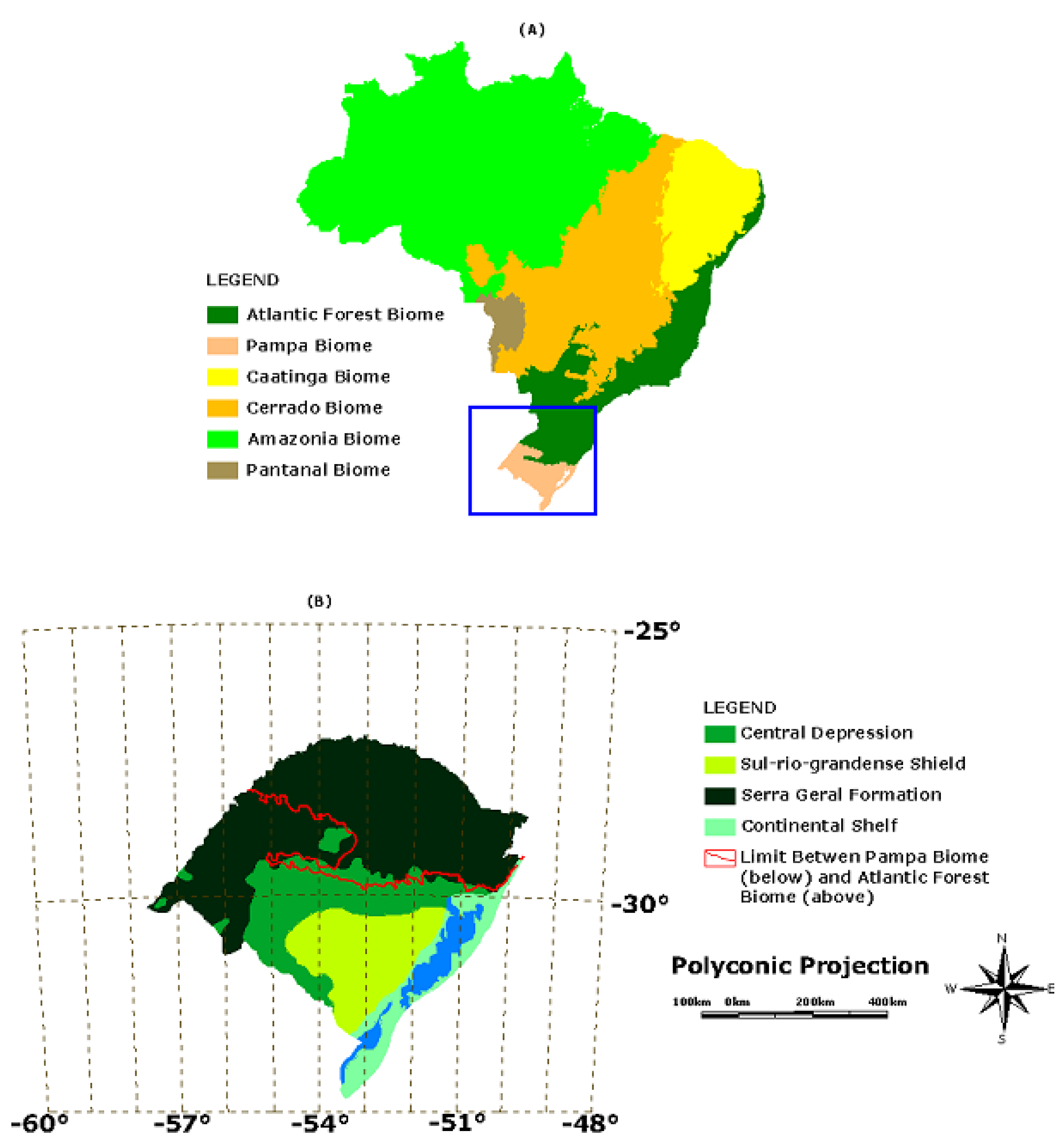
The Brazilian Pampa is located between latitudes 28º00’ S and 34º00’ S and longitudes 49º30’ W and 58º00’ W [
12], occupying an area of 63% of the Rio Grande do Sul State (
Figure 1b). The biome lies within the South Temperate Zone and has both subtropical and temperate climates with four well-characterized seasons. Grasslands, with sparse shrub and tree formations, are the dominant vegetation. [
3]. Because of the natural grasslands, livestock production is one of the main economic activities; they are a source of forage for around 18 million animals—mainly cattle and sheep [
4]. However, the soil, in much of the region, has an extremely sandy texture due to its sedimentary rock origin. The geologic material makes the soils fragile—they are highly sensitive to water and wind erosion. The natural fragility of the soil, combined with the climatic conditions means that inappropriate human activities have led to intense soil degradation. This in turn has contributed to a socio-economic fragility as evidenced by the low Social Development Index of the region [
5]. The region has experienced losses of both biodiversity and socio-economic opportunities.
Figure 1.
(a) The six terrestrial biomes according to the official Brazilian classification [
12]. (b) Map of Rio Grande do Sul State showing the four geological provinces and the limit of the Brazilian Pampa vicinity.
Figure 1.
(a) The six terrestrial biomes according to the official Brazilian classification [
12]. (b) Map of Rio Grande do Sul State showing the four geological provinces and the limit of the Brazilian Pampa vicinity.
In this review we discuss the diversity and the major biological and cultural aspects that shape this region. Our aim is to contribute toward a better understanding of the current status of this special biome and to describe how the interaction between human activities and environment affects the region, highlighting the fragility of the Brazilian Pampa.
2. Soil Diversity: Description and Conservation Status
The use of soil properties as indicator of environmental quality and sustainability has been suggested. [
6,
7]. The soil system is not just a vital precursor for crops, forage and other vegetation, it is also responsible for the regulation of the hydrologic cycle, the control of greenhouse gas emissions, the attenuation, buffering and remediation of contaminants, and the control of water and air quality. An awareness of the characteristics, potential and limitations of the soil types occurring in the Pampa biome is key to the success of primary production systems. Such knowledge is required for appropriate soil use and adoption of required conservation management practices, which are crucial for environmental, and therefore socioeconomic, sustainability.
The Brazilian Pampa is located under the Paraná Basin and comprises four geological formations, also called geological provinces (
Figure 1b) [
8,
9]: (a) Sul-rio-grandense Shield; (b) Central Depression; (c) Serra Geral Formation; (d) Continental Shelf. The Sul-rio-grandense Shield is the most ancient province where Precambrian crystalline igneous rocks (mainly granite) are the dominant parent material. The Central Depression was formed by the subsidence of a huge area composed by crystalline igneous rocks, after the Permian, generating sedimentary rocks mainly composed by arenite, siltite, and argillite. The sedimentary rocks have a diverse mineralogical composition but sandy soils dominate this province [
10]. At the end of the Cretaceous, the fragmentation of the Pangea continent suspended the sedimentation in the Paraná Basin. Subsequently, several magmatic extrusions occurred in the cracks between South America and Africa that then covered most of the sedimentary rocks. Such extrusions generated the Serra Geral Formation, located in the Northwestern portion of the Pampa biome, where basalt is the dominant parent material. The youngest parent material in the biome is located in the Southeastern portion (Coastal Plain), where recent sediments are predominant. The soil properties found in the region are closely related to the geological provinces, resulting in a great variety of soil classes (
Table 1) in the Brazilian Pampa that contribute to the biodiversity of this biome.
In the Northwestern portion of the Brazilian Pampa (Serra Geral Formation), some of the most common soils are the Orthents (classified as Neossolo Litólico and Neossolo Regolítico in the Brazilian Soil Taxonomy; see
Table 1). These soils have a low tolerance to water erosion and this characteristic places serious restrictions on the annual crops that can be grown. [
11]. They generally occur on strongly undulating slopes, on uplands and backslopes where outcrop rocks are common, and are also associated with Udoll soils (Chernossolos) on the footslopes and toeslopes. When their profile has A-C horizon sequences on saprolite, and they are present on low slopes (<15%), agriculture can be adopted if accompanied by intensive conservation practices (no tillage, terracing and permanent plant cover, among others). On greater slopes (>15%) and/or when A-R horizon sequences are present, fruit tree cultivation and forestation/reforestation is more appropriate. In more extreme cases, only natural vegetation can be sustained, constituting a permanent preservation area. Associated with the Orthent soil, the Uderts (Vertissolos) occur in the lowest parts of the slope. Due to the presence of expansive clays, they are very rigid when dried and very sticky when wet.
Table 1.
Predominant soil classes found in the Brazilian Pampa biome and its respective natural fragility. Adapted from Tornquist
et al. [
13].
Table 1.
Predominant soil classes found in the Brazilian Pampa biome and its respective natural fragility. Adapted from Tornquist et al. [13].
| U.S. Soil Taxonomy | Brazilian Soil Classification | Natural Fragility a |
|---|
| Udult | Argissolo * | | A, B |
| Udoll | Chernossolo | | A, B |
| Fluvent | Gleissolo | | B |
| Udalf | Luvissolo | | A |
| Fluvent | Neossolo Flúvico | | B, C |
| Orthent | Neossolo Litólico e Neossolo Regolítico * | | C |
| Aquent | Neossolo Quartzarênico hidromórfico | | B, C |
| Psamment | Neossolo Quartzarênico órtico | | B, C |
| Udox | Nitossolo | | A |
| Hemist | Organossolo Tiomórfico | | C |
| Aquult | Planossolo * | | A |
| Udult | Plintossolo | | B |
| Udert | Vertissolo | | A |
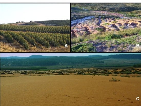
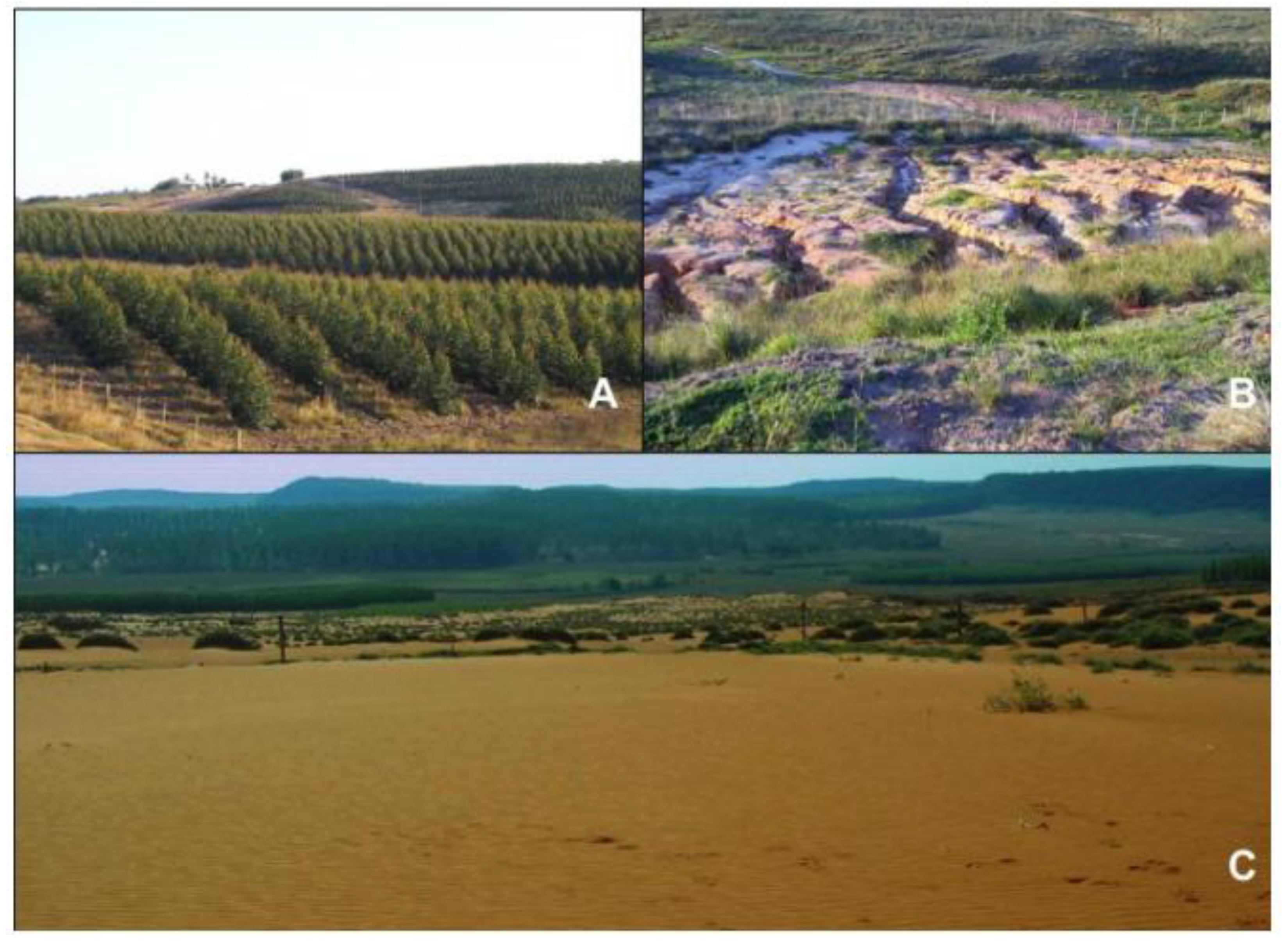
In some parts of the Northwestern region it is possible to find spots of arenite outcrops, mainly of the Botucatu formation, characterized by an extreme sandy texture. Psamment soils (Neossolos Quartzarenicos) are found here, in areas that were not covered by the magmatic extrusion or where the cover of basalt has weathered [
14]. The fragility of these soils facilitates their degradation. Intensive losses of clay, silt and organic matter are seen, concomitant with the accumulation of sand particles. In addition, the degradation has been exacerbated by agricultural and overgrazing activities (
Figure 2b,c). After the natural vegetation is lost soil organic matter becomes depleted, and the chemical, physical and biological properties of the soil become severely degraded, mainly due to the nutrient loss by leaching (cation exchange capacity from mineral particles is negligible) and the loss of soil cohesion (leading to low aggregate content of the soil). Such areas are characterized by extensive sand patches formed over unconsolidated arenitic substrates of Mesozoic origin. The degradation is very difficult to reverse. Once established, the degraded area tends to enlarge due to the intense eolic erosion common in the region. In 1995, there were about 16.75 km
2 of degraded lands caused by this process [
15]. This sequence of events, known as “sandification”, originates with the high mobility of soil sediments and the intense water and wind action. This process differs from desertification, which happens in areas of very low precipitation. The annual precipitation in the Pampean region is around 1,200–1,600 mm but nonetheless, the re-establishment of plants is very difficult (see
Figure 2c). As a consequence, the “sandification” areas expand in a positive feed-back cycle, since there are no plants to counter the erosive effects of the wind and water.
Figure 2.
Specific sites found in the Brazilian Pampa highlighting the conversion of native areas to commercial forest plantations and the fragility of the soils. (a) Commercial forest plantation of exotic tree species (Eucalyptus sp.). (b) Spots of arenite outcrops, mainly of the Botucatu formation, where extremely sandy soils exhibit damaging losses of clay, silt and organic matter. (c) The result of the “sandification” process (see text).
According to Rovedder
et al. [
16,
17], the best way to recover such soils is revegetation, but few species of plants are able to establish and thrive there. Although the Brazilian Pampa is predominantly a natural grassland region, studies have suggested that afforestation might be the most successful strategy to stop the spread of the degradation. The use of exotic fast growing plant species (e.g.,
Eucalyptus sp and
Pinus sp) has been proposed, as they are thought to be more advantageous due to their resistance [
18]. However, this idea is controversial and many researchers argue that native plants are a better choice [
19] (see discussion on item 3. Fauna and Flora: characteristics, fragility and conservation). Regardless of the species chosen for revegetation, the adoption of agriculture or grazing in such soils is strongly discouraged.
The Central Depression is primarily formed from the arenitic substrate and makes up about 14,000 km
2 in the Rio Grande do Sul State [
20]. Most soils of the region have clay content lower than 300 g kg
–1 of soil [
10] and soil organic matter content <12 g kg
–1 [
13] in the A horizon. The Central portion of this geologic province has a typical soil sequence over the landscape with a large area formed by sandy Udults (Argissolos) on the uplands, shoulders and backslopes. In the downlands, Aquults (Planossolos) are found. The Udult soils are generally well drained, with a textural gradient in their profiles. Such soils are very susceptible to water erosion and have chemical constraints due to their naturally poor fertility, with some soils having high levels of exchangeable aluminum and low base saturation. The Southwestern portion of Central Depression is predominantly formed by soft slopes where Aquults, Udolls (Chernossolos), Udalfs (Luvissolos) and Uderts (Vertissolos) are the main soil types. Therefore, in most of the area the soils are poor drained and, consequently, are generally used for flooded rice crops and grazing. Such a region is regionally called Campanha Gaúcha where the typical grassland vegetation of the Brazilian Pampa biome is found.
In the Sul-rio-grandense Shield, the Orthents (Neossolos Litólicos and Neossolos Regolíticos), and outcrop rocks are dominant. The high level of consolidation in the crystalline igneous rocks and the slopes in the region (a predominance of moderate to strong sloping) are responsible for these occurrences. The Orthent and outcrop rocks create a strong limitation on the use of the soil for crops and grazing in a vast area of the region, primarily because of the difficulties associated with the practical use of mechanical equipment.
In this context, the inherent fragility of soils in the Brazilian Pampa and its limitations on agrosilvopastoral systems are surely a key determinant of the biological potential. It exacerbates the disparity of the social and economic status of the Northern and Southern portions of the Rio Grande do Sul State. This fragility is the main feature of the soils of the Central Depression, and to the large Orthent dominated area in the Northwestern and Southern portions of the Brazilian Pampa biome, characterized by the rocky outcrops of the Sul-rio-grandense Shield.
3. Flora and Fauna: Characteristics, Fragility and Conservation
According to the classification of the Brazilian National Institute of Geography and Statistics [
12], the Brazilian Pampa is formed by a vegetation coastal belt (see
Figure 3) and by the savanna environment that dominates the whole western part of the biome. At the present time, the Pampa biome represents a climate typical for the development of forest ecosystems [
21]. However, dense forest formations are not common in the Pampa biome and grasslands dominate for reasons explored below. The main forest formations are found at the northern limit of the biome, in the transition area to Atlantic Rain Forest. In other regions, plant formations with trees are found mainly as gallery forests, “capões” (islands of trees within the grassland) and “shrub forests” [
22].
Figure 3.
Physiographic regions of the Pampa biome, based on the distribution of trees. Adapted from UFSM/SEMA-RS [
33]).
Figure 3.
Physiographic regions of the Pampa biome, based on the distribution of trees. Adapted from UFSM/SEMA-RS [
33]).
The persistence of a grassland-dominated environment in a region with climatic conditions suitable for forest development has puzzled researchers. Palynological studies demonstrated that the climatic conditions since the Last Glacial Maximum, until around 3,000 years ago were proper for a treeless ecosystem [
23,
24]. The current wetter and warmer climatic conditions allowed the expansion of forests into areas previously covered by grasses in southern and southeastern Brazilian highlands. The changes in environmental conditions were very important in shaping the actual genetic structure of some important forest species of the highlands, like
Araucaria angustifolia (for details see [
25] and references therein). A palynological study performed in a peat bog in the southern Brazilian lowland (29°35’ S, 55°13’ W) revealed the predominance of grassland pollen since the Last Glacial Maximum, around 22,150 calibrated years before the present (cal yr BP) with 95% of grassland pollen, until the present time (80 to 90% of grassland pollen), with dominance of Poaceae [
25]. As result of a too cold and relatively dry climate, gallery forests were absent in the studied region during full- and late-glacial periods, with presence of a small number of isolated trees and shrubs along the rivers [
24]. The transition from the glacial period to the Holocene reflected a change from dry and cold to a dry and warmer climate, with consequent alteration in the pollen composition of the area. Since the mid Holocene (about 5,100 cal yr BP) pollen from tree species became more frequent and abundant, reflecting the development of gallery forests along rivers. During the late Holocene (after 1550 cal yr BP), large areas of gallery forests along the rivers and some patches of forest in river valleys were formed [
24]. In spite of these changes, the Brazilian Pampa remains a mainly grass covered biome. It is generally agreed that human induced activities such grazing, and burning are most important factors hindering the expansion of forest formations over these grasslands (see e.g., [
26]).
Due to the warm and somewhat dry environment combined with the poor soil fertility, many of the plants in the Pampa biome display the characteristics typical of xerophytes [
27]. Xerophytes are plants that have adaptations for the reduction of transpiration and consequent dehydration. Among these are: hairy leaves (e.g., species from the genera
Macrosiphonia, Eupatorium, Vernolia, Lucilia, Pterocaulom, Achyrocline and
Lupinus), reduction in leaf size (e.g.,
Verbena sp and
Lippia sp,
Baccharis trimera,
Colletia cruciata and
Discaria longispina), the presence of underground structures for water and nutrient storage (e.g., Liliaceae, Iridaceae and Amarilidaceae), and the presence of tight inflorescences and presence of hard leaves (e.g., species from genera
Baccharis and
Eupatorium). Adaptations for dry climates, such as thick and hard trunks and reduced leaf area are also seen in some tree species of the Pampa (e.g.,
Prosopis algarrobilla, P. alba, Acacia caven, Parkinsonia aculeata and
Aspidosperma quebracho-blanco).
The anthropogenic use of the land—started around 9,000 cal yr BP [
24]—has changed the natural structure of the plant/animal communities, through introduction of exotic grass species and conversion of native areas to agricultural lands, grazing areas and more recently through the establishment of forest plantations (
Figure 2a). These changes mean that 48.7% of the Brazilian Pampa is now comprised of vegetation under human management [
28].
Including Pampas and Plateaus grasslands, around 3,000 to 4,000 grassland species are estimated to exist in the Southern Brazilian grassland environment. Since the Rio Grande do Sul State holds around 75% of this environment [
29], it should be a good estimation of the grassland species occurring in the Pampa biome. In spite of this high diversity, studies on plant diversity and distribution within the Brazilian Pampa indicate a typical pattern of high species richness but with low relative abundance [
22,
30,
31]. The main botanical families found in the grasslands of the Brazilian Pampa are Poaceae, Asteraceae, Cyperacea, Fabaceae, Apiacea, Oxalidaceae, Verbanaceae, and Iridaceae [
22,
29]. At least nine grassland species are endemic to the Brazilian Pampa:
Eleocharis dunensis Kük. (Cyperaceae),
Adesmia araujoi Burkart,
Adesmia bicolor (Poir.) DC.,
Arachis burkartii Handro,
Trifolioum polymorphum Poir. (Fabaceae),
Bouteloua megapotamica (Spreng.) O. Kuntze,
Melica rigida Cav.,
Stipa filifolia Nees and
Stipa philippii Steud. (Poacae) [
29]. However, according to a census made by the Brazilian Institute of Geography and Statistics [
12], from 1970 to 2006 the area occupied by grassland decreased from 14 to 8.9 millions of hectares corresponding to a conversion of grassland into other uses of about 36%. Such reduction of native grassland areas may lead to a sensitive loss of biodiversity.
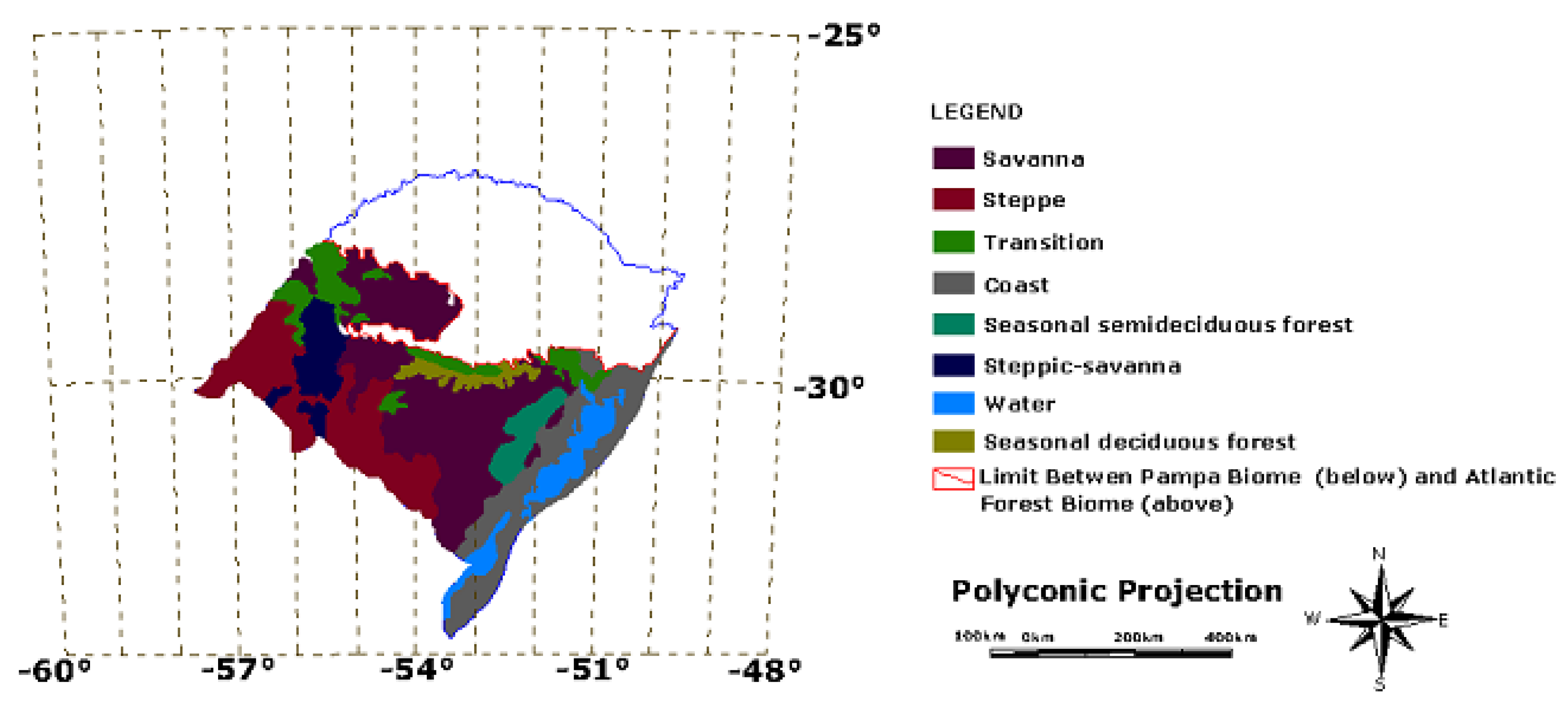
Although the Pampa biome is frequently interpreted as a pure grassland environment, it comprises at least seven different physiographic formations: savanna, steppe, steppic-savanna, coast, transition areas and patches of seasonal deciduous and semideciduous forests (
Figure 3). The main region of grassland formation (almost treeless), situated mainly at the southwestern region of the biome is called “Campanha Gaúcha”, but patches of forest can be found in many regions of the biome. The terms steppe and savanna seem to be improperly applied to the physiographic formations of the Brazilian Pampa. While steppes are typically considered to be semi-arid grasslands with a cool temperate climate (as for instance the tall and short grass prairie in North America and the Eurasian grasslands), savannas are generally defined as vegetation types with a combination of woody and herbaceous plants in distinct strata, that occur in tropical regions with clearly seasonal precipitation [
29]. Bredenkamp
et al. [
32] consider the South America Pampas similar to Eastern European steppes, in contrast to tropical grasslands. Overbeck
et al. [
29] judge the description of the pampean grasslands as savannas and steppes to be out of line with the accepted international use of these terms and suggest that the southern Brazilian grasslands should be referred to simply as “Campos”, although without classificatory justification. This reflects the biological uniqueness of the area.
Aiming for a classificatory analysis of the pampean environments (i.e., just following official documents), we divided the Pampa biome lato sensu in five main domains: (i) the coastal environment; (ii) the savanna environment; (iii) the steppe environment; (iv) the steppic-savanna environment; and (v) the Espinilho Park.
The Espinilho Park is a particular steppic-savanna environment with characteristic occurrence of
Prosopis algarobilla Gris.,
Prosopis affinis Spreng. and
Acacia caven Mol., situated within the longitudes 57° W and 58° W and latitudes 30° S and 31° S at the Brazilian border with Argentina. These three species impart a particular vegetative physiognomy to the park that is relatively rare in the other four pampean environments (see
Table 2). While differing from the other environments within the Brazilian Pampa, the Espinilho Park exhibits similarities to the Chaco vegetation in Argentina, the largest South American seasonally dry forest, which is a mosaic of xerophytic forests, woodlands, shrubs, savannas and grasslands [
34]. The dominant vegetation in the Chaco lowlands is formed by
Aspidosperma quebracho-blanco and
Schinopsis lorentzii xerophytic forests, alternating with patches of secondary woodlands and shrubs [
35].
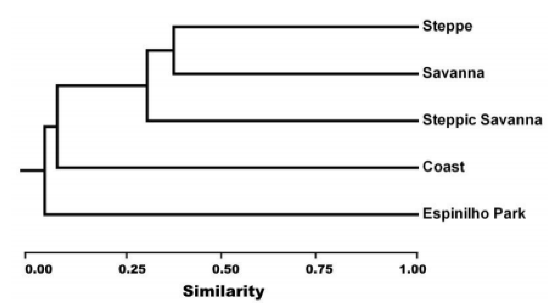
Based on 53 trees species of economic importance (
Table 2), the Espinilho Park is the most divergent among the five ecosystems considered here (just five out of 53 species shared with at least one of the other ecosystems and six species exclusively found in this environment). The steppe and savanna ecosystems are the most similar, with 41% similarity, having 11 species shared between them and five species particular to each (
Figure 4). This differentiation based on the occurrence of tree species suggests that the use of native species for reforestation—the most appropriate use of the soil in some regions (see
Table 1)—should consider those environmental differences. Based on the differences revealed in the
Figure 4 and
Table 2, it is clear that species common in the Espinilho Park are not necessarily the best choice for the reforestation of other environments within the Brazilian Pampa. Species shared in the steppe and savanna environments are better candidates. Targetting biome conservation, the use of indigenous species for reforestation is likely to meet with more success than the use of exotic ones. Information on the genetic diversity, management needs and ecological preferences of candidate reforestation species should be a priority for the selection of native tree species with high potential for forest establishment for commercial or conservation purposes.
Table 2.
Tree species of economic importance (
N = 53) found in the five main environments of the Pampa biome. Adapted from UFSM/SEMA-RS [
33].
1 X = presence of the species; - = absence of the species.
Table 2.
Tree species of economic importance (N = 53) found in the five main environments of the Pampa biome. Adapted from UFSM/SEMA-RS [33]. 1 X = presence of the species; - = absence of the species.
| Species | Steppe1 | Steppic-Savanna | Coast | Espinilho Park | Savanna |
|---|
| Acacia caven | - | - | - | X | - |
| Alchornea triplinervia | - | - | X | - | - |
| Allophylus edulis | X | X | X | - | X |
| Araucaria angustifolia | - | - | - | - | X |
| Aspidosperma quebracho-blanco | - | - | - | X | - |
| Blepharocalyx salicifolius | X | - | X | - | X |
| Casearia sylvestris | - | - | - | - | X |
| Celtis iguanaea | X | - | - | - | - |
| Celtis spinosa | - | X | - | - | - |
| Chrysophyllum marginatum | - | - | X | - | - |
| Cordia trichotoma | - | X | - | - | - |
| Coussapoa microcarpa | - | - | X | - | - |
| Cupania vernalis | - | X | - | - | X |
| Erythrina cristagalli | - | X | - | X | - |
| Erythroxylum argentinum | - | - | X | - | - |
| Esenbeckia grandiflora | - | - | X | - | - |
| Eugenia uniflora | X | X | - | - | X |
| Ficus organensis | - | - | X | - | - |
| Guapira opposita | - | - | X | - | - |
| Lithraea brasiliensis | X | - | X | - | X |
| Lithraea molleoides | X | X | - | X | X |
| Luehea divaricata | X | X | X | - | X |
| Matayba elaeagnoides | - | - | X | - | X |
| Myrcia brasiliensis | - | - | X | X | - |
| Myrcianthes cisplatensis | - | X | - | X | - |
| Myrcianthes pungens | - | X | - | - | - |
| Myrciaria tenella | - | X | - | - | - |
| Myrrhinium atropurpureum | - | X | - | - | - |
| Myrsine laetevirens | X | X | - | - | - |
| Myrsine umbellata | - | - | X | - | - |
| Nectandra megapotamica | - | - | - | - | X |
| Ocotea acutifolia | X | - | - | - | - |
| Ocotea pulchella | - | X | - | - | X |
| Parapiptadenia rigida | X | - | - | - | X |
| Parkinsonia aculeata | - | - | - | X | - |
| Patagonula americana | X | X | - | - | X |
| Podocarpus lambertii | - | - | - | - | X |
| Pouteria gardneriana | X | X | - | - | - |
| Pouteria salicifolia | - | - | - | X | - |
| Prosopis affinis | - | - | - | X | - |
| Prosopis nigra | - | - | - | X | - |
| Quillaja brasiliensis | X | - | - | - | X |
| Ruprechtia laxiflora | X | X | - | - | - |
| Schinus lentiscifolius | X | - | - | - | - |
| Scutia buxifolia | X | X | - | X | X |
| Sebastiania brasiliensis | X | - | - | - | - |
| Sebastiania commersoniana | X | X | - | - | X |
| Sideroxylum obtusifolium | - | - | X | - | - |
| Styrax leprosus | X | - | - | - | - |
| Syagrus romanzoffiana | - | - | X | - | - |
| Trichilia claussenii | - | - | X | - | - |
| Vitex megapotamica | - | - | - | - | X |
| Zanthoxylum fagara | - | - | X | - | - |
| Number of species | 19 | 19 | 18 | 11 | 19 |
Figure 4.
Relationship among five environments of the Pampa biome based on occurrence of economically important tree species. The dendrogram was drawn based on Jaccard`s Index of similarity [J (A,B) = (A∩B)/(AUB)] and the unweighted pair group method with arithmetic mean (UPGMA) algorithm.
Figure 4.
Relationship among five environments of the Pampa biome based on occurrence of economically important tree species. The dendrogram was drawn based on Jaccard`s Index of similarity [J (A,B) = (A∩B)/(AUB)] and the unweighted pair group method with arithmetic mean (UPGMA) algorithm.
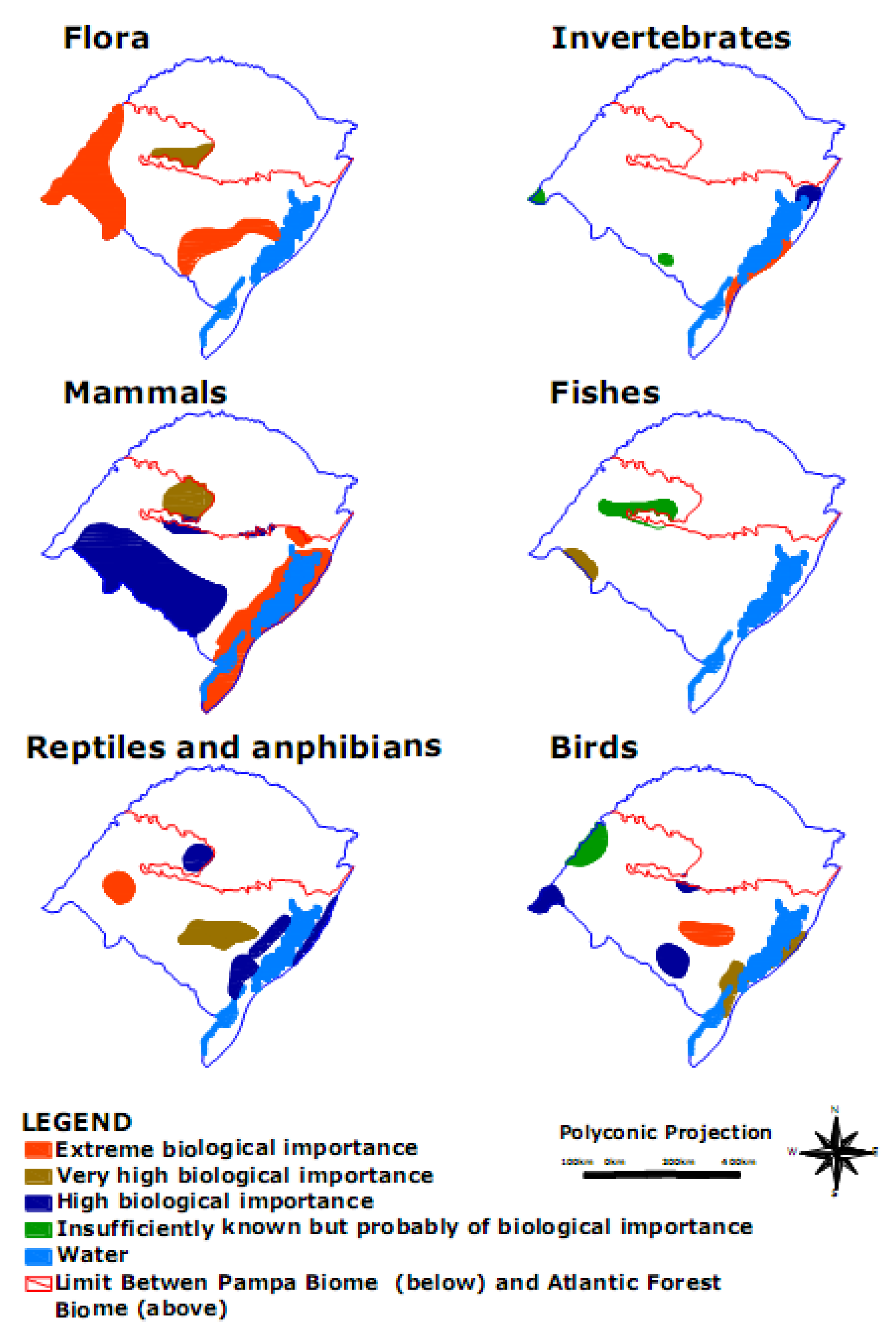
The natural pampa biome is being eroded by ongoing conversions to cropland, grazing and exotic species forest plantations, and there is a need to identify areas for conservation. [
36]. A broad study executed through the Project of Conservation and Sustainable Use of the Biological Diversity—ProBio of the Brazilian Ministry of Environment [
37], identified areas of biological importance for the conservation of the flora and fauna biodiversity in the Pampa biome. A most recent document from ProBio [
38] corroborated the results earlier published.
Figure 5.
Areas of importance for conservation of the flora and fauna biodiversity in the Pampa biome. Adapted from MMA [
37].
Figure 5.
Areas of importance for conservation of the flora and fauna biodiversity in the Pampa biome. Adapted from MMA [
37].
Priority areas for the conservation of the flora of the Brazilian Pampa must take into consideration the fact that the natural plant communities are both highly fragmented and probably quite divergent (unique). From this perspective, prioritization attempted to include the full geographic scope of the remnants of these ecosystems (
Figure 5).
Priority areas for the conservation of the faunal diversity, including both vertebrate and invertebrate taxa, encompass some areas in common with plant priority areas. These high priority faunal areas are somewhat more dispersed and smaller, with the exception of some areas chosen for mammal conservation (see
Figure 5). The process of identifying priority areas for the conservation of invertebrates in the Pampa revealed a severe scarcity of knowledge about these animals, even when studying the better-known groups of invertebrates—ants, butterflies, opilionids and spiders—
i.e., species of recognized importance for ecosystem management, poisonous species and species useful as environmental indicators. Regarding fish species, the Brazilian Pampa is considered to be extremely heterogeneous due to the geomorphological distinctiveness of the drainage basins in this biome. These watersheds have a long history of isolation, and therefore served as the basis for the establishment of priority areas for conservation. The identification of priority areas for the conservation of reptile biodiversity in the Brazilian Pampa revealed some endemics and also threatened species, like the endangered species
Anisolepis undulatus, Bothrops jararacussu, and
Siphlophis longicaudatus [
39]. Amphibians have a limited capacity to move between the humid environments where they must live, and accordingly a high rate of endemism is found within this group of vertebrates. Areas of importance for conservation of reptilian and amphibian fauna in the Brazilian Pampa include the Espinilho Park in the southwestern region of the Pampa, savannas in the central part of the biome and coastal environments. The diversity of birds is one of the more studied aspects of Brazilian fauna. Inventories have revealed a number of threatened Brazilian bird species: Birds threatened in the Pampa (e.g.,
Culicivora caudacuta,
Spartonoica maluroides,
Tyngites subruficollis,
Geranoaetus melanoleucus,
Circus cinereus,
Sporophila cinnamomea,
Gubernatrix cristata,
Xanthopsar flaws) [
39] are the basis for planning conservation efforts and recovery strategies. At least six areas of biological importance with respect to bird diversity can be delimited within the Brazilian Pampa. Among the mammals of the Brazilian Pampa some endemic species are found, like the rodent
Ctenomys flamarioni, native of the coastal environment, while some species of mammals are threatened (e.g.,
Crhysocyon brachyurus,
Oncifelis colocolo,
Ozotoceros bezoarticus; [
39], as a consequence of non-sustainable use of the land. For the mammals of the Brazilian Pampa, two large areas are considered of high importance for biological conservation of species, one in the savanna region and one in the coastal region.
5. Cultural Diversity and Socioeconomic Status
People act according to the condition of the economy, their social situation, politics and the history of their surroundings. Since the regional characteristics are the result of the interactions between human and nature, the alterations in the biome will in turn cause alterations in the behavior of the human beings who live in the region, ultimately affecting their cultural identity. The actual economic model of the Brazilian Pampa is based on agriculture and livestock production.
It is important to highlight that the region where the Brazilian Pampa exists played a central role in the cultural and economic history of the last decade. Large farms have become dominant and they account for the majority of recent investments in crop production. The residents of the South American Pampas called “Gaúchos” developed a strong tradition based on the livestock in association with crop rotation using rice, soybeans, corn and wheat, which is reflected in the different habits, costumes and daily practices of various communities. This incorporation of nature in culture was strongly influenced by the countries in the vicinity, mainly Uruguay and Argentina. The people living in the Brazilian Pampa implemented an extractive system essentially based on natural resources, mainly the natural grasslands. The system was based upon intuition and common sense methodologies from previous knowledge brought by immigrants or from the daily in the field. After a short period of time (couple of decades) this system started to decline (e.g., due to sandification—see discussion on item 2. Soil Diversity: description and conservation status) and new challenges emerged. The scenario has been strongly altered in the last four decades causing crisis in the agricultural sector. In the last demographic census, the Brazilian Institute of Geography and Statistics [
12] registered a high level of population mobility mainly caused by the crisis and by need for labor in the large urban centers. A comparison between the cities in the northern region of the Rio Grande do Sul State, which are located outside of the Pampa biome, and the cities of the southern region, which are located within the Pampa biome, reveals large differences in the Social Development Index (SDI), which derives from data on education, households, labor and income. The northern region presents high Social Development indices while the indices vary from medium to low in the cities located in the Pampa biome. The cost of transporting goods to consumption centers and the lack of added value contributes to the discrepancies in SDIs.
The differences between northern and southern regions of Rio Grande do Sul are not only geographical but also related to the process of colonization and the history. Most of the colonizers of the Brazilian Pampa were from Spanish or Portuguese origin, while the northern region was markedly influenced by people with diverse origins mainly from Germany, Italy and Poland, among others. The poor economic and social conditions of the native people from the Brazilian Pampa are closely related to their history and the resources available for exploitation. The colonization process was fundamentally based on the natural resources of the region. In XVIII century, the major objective was the enrichment of the metropolis without concern for the development of the colony. Due to the necessity to occupy the land quickly, Portugal and Spain established an economy based on monoculture and livestock. The Grassdominated vegetation and the extractive mind set were the most prevalent factors that determined land use in the Pampas. Leather was the first most profitable product of the region and together with the “erva-mate” (
Ilex paraguariensis), most popular tea in the South American region, made up the basis for the economy at that time [
40].
After the 60’s, the Rio Grande do Sul State found new ways to diversify the economy. This change required an intensification of agricultural activity. Such intensification brought an uncontrolled and accelerated expansion of the agricultural frontiers. The fragile biome did not support the intense use of the natural resources. The demographic expansion and attendant consumption outpaced the rate of renewal of the biotic resources, and it led, and is still leading, the environmental degradation. Soil, water and air are being contaminated by organic and inorganic pollutants and the soil productivity is being lost. The unsustainable production rate, the mechanization, the introduction of exotic species and the cultivation of monocultures, among others factors, have contributed to the degradation of this unique Biome, but more informed uses can make its continued existence possible.

 ,
, 


